City of Del Mar Staff Report
←
→
Page content transcription
If your browser does not render page correctly, please read the page content below
City of Del Mar
                           Staff Report
PLANNING COMMISSION
STAFF REPORT
January 12, 2021

APPLICATION: Proposed Housing Element Implementation Overlay Zone and Implementation of
Programs 2E (North Commercial) and 2G (two vacant parcels at the corner of Jimmy Durante
Boulevard/San Dieguito Drive) in the North Commercial Zone (5th Cycle Housing Element) – Local
Coastal Program Amendment (LCPA 20-003), General Plan Amendment (GPA 20-004), Zone Code
Amendment (ZA 20-003), and Rezone (RP 20-001)

REQUEST: This is a request for the Planning Commission to review and consider the project’s
proposed actions and provide a recommendation to the City Council to timely approve all actions
for compliance with State law (including applicable California Environmental Quality Act, Housing
Element, and Coastal Act laws) prior to April 15, 2021, to minimize or avoid State enforcement
penalties including fines, Housing Element decertification, and referral to the Attorney General’s
office. The proposed actions for compliance with the 5th Cycle Housing Element and State
Housing law (California Government Code Sections 65583.2(h) and (i)) include:

    1) Local Coastal Program Amendment (LCPA 20-003) to reflect a new Housing Element
    Implementation Overlay Zone to implement Government Code §65583.2(h) and (i) and
    change the land use designation and zoning for North Commercial to demonstrate compliance
    with Housing law and the Coastal Act;

    2) General Plan Amendment (GPA 20-004) to amend the North Commercial land use
    designation per Housing Element Programs 2E and 2G in accordance with State law (see
    Exhibit A);

    3) Zone Code Amendment (ZA 20-003) to create and implement a new Housing Element
    Implementation Overlay Zone per Housing Element Program 2G in accordance with State
    law (see Exhibit B); and

    4) Rezone (RP 20-001) per Housing Element Program 2G to apply the new Housing Element
    Implementation Overlay Zone to real property identified as APNs 299-100-47 and 299-100-
    48 located in the North Commercial Zone.

APPLICANT: City of Del Mar

STAFF CONTACTS: Amanda Lee, Principal Planner
                Joseph D. Smith, AICP, Planning & Community Development Director

LOCATION: The proposed Community Plan Amendment would apply to all property in the North
Commercial Zone that is subject to the North Commercial land use designation (with certain
development restrictions on properties adjacent to the San Dieguito River and Lagoon) and the
PLANNING COMMISSION
STAFF REPORT:
5th Cycle Housing Element Programs 2E and 2G
January 12, 2021
Page 2
proposed Rezone action would apply specifically to two vacant parcels located at the south corner of
Jimmy Durante Boulevard/San Dieguito Drive identified as APNs 299-100-47 and 299-100-48
located in the North Commercial Zone.
ENVIRONMENTAL STATUS: Pursuant to the California Environmental Quality Act (CEQA), the
proposed actions on Program 2G have been analyzed and determined to be Statutorily Exempt
pursuant to CEQA Guidelines Section 15265 because the proposed action constitutes an amendment
to the City’s certified Local Coastal Program (LCP) and CEQA does not apply to activities or
approvals by a local government as necessary for the preparation and adoption of a LCP amendment
for review and certification by the California Coastal Commission (CCC) as set forth in Section
21080.9 of the Public Resources Code. Accordingly, the certified City of Del Mar LCP constitutes a
plan for use in the CCC’s regulatory program as certified under Section 21080.5 of the Public
Resources Code. The proposed actions on Program 2G include corollary amendments to the City’s
Community Plan (General Plan) and Municipal Code (Zoning). Notwithstanding the applicability of
the Statutory Exemption, future development of the two parcels included in Program 2G for multiple
dwelling residential use as affected by the proposed actions, as well as the proposed action on Program
2E have been the subject of prior environmental analysis including the Final Program Environmental
Impact Report (PEIR) for the Professional Commercial and North Commercial Zoning Code
Amendment (SCH #2019029058) certified by the City Council on September 8, 2020 (Resolution
2020-47) and the 6th Cycle Housing Element Update Final PEIR (SCH No. 2020029064) certified
by the City Council on October 5, 2020 (Resolution 2020-52). Anticipated impacts for the proposed
actions have been disclosed in these prior environmental documents and the proposed Housing
Element Implementation (HEI) Overlay Zone incorporates standard Mitigation Monitoring and
Reporting protocols (see proposed Section 30.92.050) to ensure impacts are minimized consistent
with prior environmental documents. No new or substantially greater impacts would result from
implementation of Programs 2G and 2E, including the HEI Overlay Zone. As such, pursuant to CEQA
Guidelines Sections 15162 and 15163, and based on the review of the entire record, including without
limitation, the Final PEIRs referenced above, the proposed actions do not require further
environmental review. Pursuant to CEQA Guidelines Section 15162(b), no further analysis or
environmental documentation is necessary. Accordingly and notwithstanding the applicability of the
Statutory Exemption referenced above, the proposed actions are merely a step in furtherance of the
original programs for which environmental review was performed, no supplemental or subsequent
CEQA has been triggered, and no further environmental review is required. See Exhibit C for
supplemental environmental documentation prepared by Recon.
Final 6th Cycle PEIR: www.delmar.ca.us/DocumentCenter/View/7171/Final-PEIR-91020
Final NC/PC PEIR: www.delmar.ca.us/Archive.aspx?ADID=1428
BACKGROUND:
The Housing Element is a State-mandated policy document within the Del Mar Community Plan,
which is the General Plan for the City of Del Mar. On October 5, 2020, the City Council approved
the draft 6th Cycle Housing Element Update (HEU) for years 2021-2029, which is under review
and comment by the State Department of Housing and Community Development (HCD). State
certification of the 6th Cycle HEU is dependent upon completion of 5th Cycle Housing Element
requirements that require the City to have created adequate sites at sufficient density (sites that
allow at least 20 dwelling units per acre) to support development of housing affordable to lower
PLANNING COMMISSION
STAFF REPORT:
5th Cycle Housing Element Programs 2E and 2G
January 12, 2021
Page 3
income households. An “affordable” unit is considered a unit that is made available to “extremely
low,” “very-low,” and “low” income households who earn an annual household income no greater
than a given percentage of the area median income (AMI) for the San Diego County region
($92,700 in 2020).
More information on the percentages of AMI based on family size is available here:
www.sandiegocounty.gov/content/sdc/sdhcd/rental-assistance/income-limits-ami.html
The City’s current Housing Element is for the 5th Cycle, which covers years 2013-2021. The City
is still in process of completing the required actions for three 5th Cycle housing programs: Program
2E (North Commercial allowance for 20 dwelling units per acre), Program 2F (Professional
Commercial allowance for 20 dwelling units per acre), and Program 2G (Rezone of two vacant
parcels in the North Commercial zone to allow housing “by-right” at 20-25 dwelling units per
acre). The 5th Cycle Program 2G is specifically tied to APNs 299-100-47 and 299-100-48, which
are vacant lots that were identified by the City as “adequate sites” to support the development of
affordable housing. The City is required to complete Programs 2E, 2F, and 2G or otherwise must
process approval of an equivalent replacement that creates sites with sufficient density (allowing
at least 20 dwelling units per acre).
During the 5th Cycle, a “Watermark Specific Plan” was in process via a private development
application that would have satisfied the 5th Cycle Program 2G rezone requirement had it been
implemented. However, following the City Council votes on September 8 and October 5, 2020,
which failed to pass approval of a Community Plan Amendment to allow multiple dwelling unit
housing in North Commercial, the applicant decided to withdraw their Specific Plan application
and pursue a permit application pursuant to Senate Bill 330 for “by-right” processing of a multiple
dwelling unit project with units that will be reserved for lower income households consistent with
Program 2G. However, it is still the City’s obligation to take action to modify its zoning to create
adequate sites at sufficient density for lower income housing per Programs 2E, 2F, and 2G in
preparation for the 6th Cycle. The 5th Cycle programs must be completed by April 15, 2021, which
marks the end of the 5th Cycle planning period and beginning of the 6th Cycle planning period, at
which time the City is expected by the HCD to have adequate sites available and a certified 6th
Cycle Housing Element in place to cover the next planning period for years 2021-2029.
The City currently does not have any “adequate sites” at sufficient density or any affordable
housing units available for rent to lower income households. However, the City is in process of
creating adequate sites to meet State Housing law. On September 21, 2020, the City Council
adopted a Resolution and Ordinance to implement the 5th Cycle Housing Element Program 2F to
create adequate sites in the Professional Commercial (PC) by amending the land use designation
and zone to allow residential up to 20 du/ac. Certification by the Coastal Commission is needed
for the Ordinance to take effect. The City Council also adopted an Ordinance on October 19, 2020
to implement 5th Cycle Housing Element Program 2E to create adequate sites in the North
Commercial (NC) by amending the zone to allow residential up to 20 du/ac. The City Council did
not amend the North Commercial land use designation at that time and still must amend the
Community Plan per Program 2E. The Program 2E and 2F LCPA applications were both submitted
to the Coastal Commission on November 4, 2020 for final certification.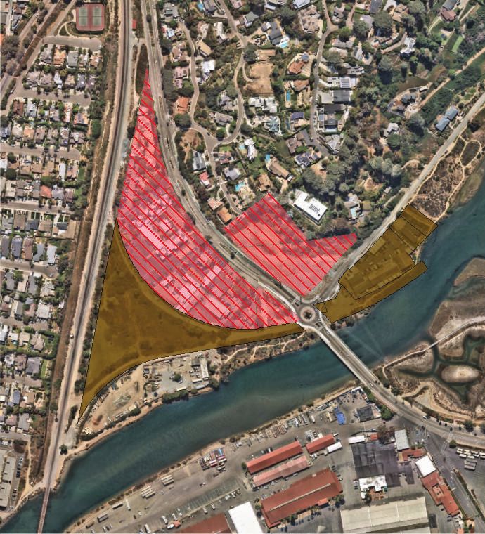
PLANNING COMMISSION
STAFF REPORT:
5th Cycle Housing Element Programs 2E and 2G
January 12, 2021
Page 4

The proposed actions outlined in this report would effectively address the remaining 5th Cycle
Programs 2E component and 2G, including processing of General Plan Amendment 20-004 to
incorporate an amended North Commercial land use designation and map to allow multiple
dwelling unit housing on specified parcels within the NC land use designation per 5th Cycle
Program 2E and explicitly identify the two parcels per 5th Cycle Program 2G that allow a higher
density of “by-right” residential development at 20-25 dwelling units per acre.

City Council approval of the proposed 2E and 2G implementation actions is needed as soon as
possible so that the City can demonstrate to HCD its progress towards completion of the required
5th Cycle Housing Element Programs before April 15, 2021. Any further delay will put the City
at risk of decertification of its existing Housing Element, referral to the Attorney General, penalties
including fines, a requirement for more frequent Housing Element update cycles every 4 years
(instead of every 8 years), and imposition of additional by-right housing development in the North
Commercial zone for the 6th Cycle due to the City’s failure to timely create adequate sites. See
Exhibit D for the penalties applicable to cities that do not comply with State Housing law.

ANALYSIS:
The Planning Commission is asked to provide a recommendation to the City Council on whether
to approve the Local Coastal Program Amendment, General Plan Amendment, Zone Code
Amendment, and Rezone actions. The following analysis identifies the effect of the proposed
actions to amend the North Commercial land use designation, create the Housing Element
Implementation Overlay Zone, and rezone the two vacant parcels per 5th Cycle Program 2G.

Amendment to North Commercial Land Use Designation in the Del Mar Community Plan
The existing North Commercial land use designation in the Community Development Section of
the Del Mar Community Plan is proposed to be amended to implement 5th Cycle Housing Element
Programs 2E and 2G. The North Commercial designation applies to parcels located in the “Valley
District” and “North Hills District” areas of the community. The Community Plan “Valley
District” is the area of the community that applies to non-residential properties in the Fairgrounds,
Floodway (subject to flooding from the San Dieguito River and Lagoon), or North Commercial
zones. Most of North Commercial (14 of 16 total lots) is located within the Valley District. The
remaining two lots in North Commercial are located within the Community Plan “North Hills
District”, which primarily applies to residential properties in the R1-40 and R1-10 zones that are
located on the hill to the southeast and generally at a higher elevation than North Commercial.

The existing land use designation specifies that North Commercial is intended to allow activities
that provide a service to the community, including “a range of commercial and light industrial
uses”. The North Commercial land use designation would be amended to also allow multiple
dwelling unit residential at 20 du/ac. There would be no change to the existing development
standards (i.e., height, floor area ratio, lot coverage, parking), which is in keeping with the intent
of North Commercial to maintain development “of low intensity and profile, offering substantial
open space”.
PLANNING COMMISSION
STAFF REPORT:
5th Cycle Housing Element Programs 2E and 2G
January 12, 2021
Page 5
In order to clarify the North Commercial locations where multiple dwelling unit residential would
be allowed, a new land use map Figure would be included with the amended land use designation
(see Exhibit A). To assure priority for coastal-dependent and coastal-related development that
avoids impacts to sensitive wetland habitat, the following locations would continue to prohibit
multiple dwelling unit housing: NCTD-owned wye property (APN 299-071-02-00) located west
of Jimmy Durante Boulevard and five parcels (299-100-32-00, 299-100-33-00, 299-100-34-00,
299-100-35-00, 299-100-36-00) located north of San Dieguito Drive on the east side of Jimmy
Durante Boulevard. This equates to 6.78 acres being identified as prohibited for multiple dwelling
unit use out of the approximately 16 acres total in North Commercial.

Multiple dwelling unit use would be allowed on the remaining parcels located away and inland
from the San Dieguito Lagoon within an existing developed context where there is suitable access
and development potential. These parcels are immediately adjacent to Jimmy Durante Blvd. The
proposed amendment would also clarify that the two vacant North Commercial parcels (APNs
299-100-47-00 and 299-100-48-00) in the North Hills District will allow “by-right” multiple
dwelling units at a density of 20-25 dwelling units per acre per 5th Cycle Housing Element Program
2G and the California Government Code §65583.2(h) and (i).

Following is a Table showing the sixteen parcels in the NC zone and the maximum potential
number of multiple dwelling units that could be yielded per lot at a density of 20 du/ac under the
proposed Community Plan Amendment:

                                                                       Acreage        Potential # of
         APN              Owner                   Address
                                                                                          Units
1    299-071-02-00        NCTD                      N/A                  4.44              0
2    299-100-50-00    City of Del Mar               N/A                  0.02               0
3    299-100-49-00      Marten, RT        2236 Jimmy Durante Blvd.       0.42               8
4    299-100-30-00    Matthews, Erin      2148 Jimmy Durante Blvd.       0.38               8
5    299-100-28-00   Read Family LLC      2126 Jimmy Durante Blvd.       0.51              10
6    299-100-29-00   Stonebreaker Trust   2132 Jimmy Durante Blvd.       0.51              10
7    299-100-27-00   Knorr, Donna Trust   2120 Jimmy Durante Blvd.       0.90              18
8    299-071-06-00    Bungalows LLC       2010 Jimmy Durante Blvd.       2.12              42
9    299-071-07-00    Westech Realty      2002 Jimmy Durante Blvd.       1.42              28
10   299-100-48-00     Watermark LP                 N/A                  1.55              31
11   299-100-47-00     Watermark LP                 N/A                  1.13              23
12   299-100-32-00    City of Del Mar               N/A                  0.04               0
13   299-100-33-00        NCTD                      N/A                  0.68               0
14   299-100-34-00   2201 Del Mar LLC     2201 San Dieguito Drive        1.13               0
15   299-100-35-00     Scarab Group       2195 San Dieguito Drive        0.26               0
16   299-100-36-00      S.C. Edison                 N/A                  0.23               0
                                                                                       178 Total
                                                                                     Potential Units
PLANNING COMMISSION STAFF REPORT: 5th Cycle Housing Element Programs 2E and 2G January 12, 2021 Page 6 As compared to the previous versions of the amendment considered by the City Council on September 8 and October 5 and 19, 2020, the proposed/revised Community Plan Amendment language for Program 2E would now explicitly prohibit the potential for multiple dwelling use on 6.78 acres in the NC zone. This translates to a significant reduction in the potential number of units (removal of 6 lots and 136 potential units) when considering the assumptions initially analyzed in the NC/PC PEIR for the worst case scenario, which assumed maximum build out of housing on all parcels in the NC zone. The significant reduction in potential units per the modified proposal was accomplished by clustering all potential for multiple dwelling unit residential development on parcels located along Jimmy Durante Boulevard and inland/away from the lagoon and riverbank edge. While it had previously been explained that existing environmental and coastal-related policies and regulations in the City’s Community Plan and certified Local Coastal Program would not have allowed a worst case scenario build out of multiple dwelling unit housing on all parcels in the NC Zone, the proposed NC Community Plan land use designation has since been modified to more realistically reflect that only interior parcel locations away from the Lagoon could prospectively be developed with multiple dwelling units to meet the City’s housing obligations. This change is intended to address the community concerns over this program that have been expressed and heard. As a result of the revised implementation approach, the maximum housing development potential has been lowered by 43% from 314 potential units to 178 potential units under this revised Community Plan Amendment. Also, as part of additional study that has been conducted for this area for the 6th Cycle Housing Element Update, the City is aware that realistically even fewer housing units are likely to be developed over the next housing cycle (2021-2029) due to existing specialized uses (i.e., free flight bird sanctuary and the veterinary clinic) that are not likely to be redeveloped and replaced with housing. The proposed Community Plan amendment is consistent with the requirements per State Housing law and the City’s certified Local Coastal Program. Per the Coastal Act, housing is not a priority use in commercial zones, particularly in locations adjacent to the Floodway Zone or substantially constrained by environmentally sensitive habitat. In accordance with the City’s certified LCP, priority will continue to be given to coastal-dependent and coastal-related uses in such locations where consistent with the provisions of the Lagoon Overlay Zone. As proposed, the Community Plan Amendment will effectively address the City’s obligation to amend the North Commercial land use designation per 5th Cycle Housing Element Programs 2E and 2G. (City Council action on the Community Plan Amendment is not subject to certification by the Coastal Commission.) Creation of Housing Element Implementation Overlay Zone A new Housing Element Implementation (HEI) Overlay Zone is proposed to facilitate implementation of required housing-related rezone programs where required for compliance with State Housing Element law. Once created, the HEI Overlay Zone could be applied to parcels throughout the City via rezone actions in the future as necessary to implement the City’s Housing Element. The proposed HEI Overlay Zone would be located in Del Mar Municipal Code (DMMC) Chapter 30.92 and would identify the areas of applicability. Initially, via the proposed rezone action the HEI Overlay Zone will apply only to the two vacant parcels in North Commercial that are currently owned by Watermark LP.
PLANNING COMMISSION
STAFF REPORT:
5th Cycle Housing Element Programs 2E and 2G
January 12, 2021
Page 7

The HEI Overlay Zone identifies the process for permit approval, development standards, and
mitigation, monitoring, and reporting requirements that are required of all new development within
the HEI Overlay Zone. Pursuant to State law, rezone programs in the HEI Overlay Zone will be
subject to an administrative level ministerial approval process where submitted development
applications will be reviewed for compliance with the published development standards and
mitigation, monitoring, and reporting criteria. Due to the allowances in State Housing law, an
administrative Coastal Development Permit (CDP) shall be required for proposed development. This
means that the Planning Director will approve the CDP application if the proposed housing
development is consistent with the requirements of the certified Local Coastal Program. A clarifying
amendment is proposed in DMMC Section 30.75.080(E) to clarify that the Planning Director is the
Issuing Authority for this type of permit, which is similar to the process for Accessory Dwelling Unit
(ADU) permitting. DMMC Section 30.75.140 states the required findings for permit approval. No
local public hearing can be required. Once a final decision is made it must be reported to the Executive
Director of the Coastal Commission and to any interested parties who request notice in writing. Public
notice will be provided in accordance with DMMC Section 30.75.120. Within the appealable area of
the coastal zone (property located between the first public road and the sea, within 300 feet of a beach
or the mean high tide line, or within 100 feet of a wetland or stream), the Planning Director’s decision
is appealable to the Coastal Commission within 10 calendar days per DMMC Section 30.75.110.
Once an administrative CDP is approved, the applicant may apply for an administrative level approval
of Construction Permits per DMMC Chapter 23.05.

The development standards applicable to proposed development in the HEI Overlay Zone shall be in
accordance with the applicable base zone and overlay zones, unless otherwise indicated. In addition,
the applicant must demonstrate compliance with all of the objective standard protocols for mitigation,
monitoring, and reporting as identified in the HEI Overlay Zone. The purpose of the standards is to
provide predictability for applicants to demonstrate how their proposed project has avoided a
significant effect to the environment in accordance with applicable State and Federal laws. The
standards cover cultural resources including historic resources, offer for Native American
consultation, archaeological surveys, and monitoring; biological resources including identification of
sensitive biological resources, delineation of wetlands, provision of wetland buffers, and avoidance
of impacts to environmentally sensitive habitat areas; construction noise reduction measures and on-
site noise reduction; paleontological resources including standard protocols and monitoring;
protection of public views per the certified LCP; protection of steep slopes per the certified LCP; and
protection of the public health and safety from wildfire risk per State Fire and Building Codes. The
requirements for offers to consult with and monitor projects in coordination with California Native
American tribes are consistent with the technical advisory bulletin published by the Governor’s Office
of Planning and Research regarding required implementation of Assembly Bill 168 and guidance to
lead agencies regarding required procedures that took effect September 2020.

Rezone of Watermark Parcels in the North Commercial Zone
Consistent with 5th Cycle Housing Element Program 2G, the two parcels in North Commercial
(APNs 299-100-47-00 and 299-100-48-00) that are designated to allow multiple dwelling unit “by-
right” residential at a density of 20-25 dwelling units per acre would be subject to a rezone action
to apply the new HEI Overlay Zone. The rezone action is proposed to apply a new Overlay Zone
PLANNING COMMISSION
STAFF REPORT:
5th Cycle Housing Element Programs 2E and 2G
January 12, 2021
Page 8
instead of changing the base zone because all of the use allowances and development standards of
the underlying base zone (NC) will continue to apply to these parcels with the exception of the
density. The Overlay Zone specifies the right of these parcels to increased density in the range of
20-25 dwelling units per acre per 5th Cycle Program 2G and applicable Housing Element law.

The current property owner of APNs 299-100-47-00 and 299-100-48-00 (Watermark LP)
submitted a Preliminary Development Application (PDA20-001) for a “by-right” multiple
dwelling unit housing development project (submitted November 24, 2020) pursuant to Senate
Bill 330, which locked in the development standards for their proposed project. This means that
the new regulations in process to implement Program 2G technically will not be applicable to the
Watermark permit application in process. The Watermark development project is being processed
entirely separate from the proposed actions described in this report and should not be considered
by the Planning Commission as a part of its recommendation to City Council on the proposed
actions. However, it should be noted that the proposed objective standards that would be published
in the HEI Overlay Zone are intended to reflect the standard criteria and protocols that are expected
of any such housing project that is required to be processed through an administrative level
ministerial process instead of the City’s typical discretionary permit process.

RECOMMENDATION:
Staff recommends that the Planning Commission take the following actions:

   1.   Recommend that the City Council adopt the Local Coastal Program Amendment
   2.   Recommend that the City Council adopt the General Plan Amendment
   3.   Recommend that the City Council adopt the Zone Code Amendment
   4.   Recommend that the City Council adopt the Rezone

Respectfully submitted,

Amanda Lee
Principal Planner

Attachments:
Exhibit A – Draft Community Plan Amendment
Exhibit B – Draft Housing Element Implementation Overlay Zone
Exhibit C – Environmental Documentation
Exhibit D – Penalties for Non-Compliance with State Housing Law
Exhibit A

12.21.2020

             Draft Language Amending the Community Plan Relating to North Commercial

   Amend the North Commercial land use category section in the Del Mar Community Plan Community
   Development per 5th Cycle Housing Element Programs 2-E and 2-G to read as follows:

   North Commercial
   This land use classification is intended to allow commercial and professional activities that provide
   a service to the community, including a range of commercial and light industrial uses, and
   residential uses. Development should be of low intensity and profile, offering substantial open
   space. Multiple dwelling unit residential at a density of 20 dwelling units per acre is an allowed use
   on parcels as shown on the Figure below. To assure priority for coastal-dependent and coastal-
   related development that avoids impacts to sensitive wetland habitat and the San Dieguito River
   and Lagoon, multiple dwelling unit residential use should be prohibited in the Community Plan
   Valley District on the North County Transit District (NCTD)-owned wye property (APN 299-071-02-
   00) located on the west side of Jimmy Durante Boulevard and parcels located north of San
   Dieguito Drive on the east side of Jimmy Durante Boulevard (299-100-32-00, 299-100-33-00, 299-
   100-34-00, 299-100-35-00, 299-100-36-00).

   Pursuant to 5th Cycle Housing Element Program 2-G, which is required by California Government
   Code Sections 65583(c)(1)(A) and 65583.2(h) and (i), two parcels in North Commercial (APNs 299-
   100-47-00 and 299-100-48-00) located south of the corner at Jimmy Durante Boulevard and San
   Dieguito Drive in the Community Plan North Hills District are designated to allow “by-right” multiple
   dwelling unit residential at a density of 20-25 dwelling units per acre.
12.21.2020
Exhibit B

DRAFT 12.21.2020

                   Proposed Housing Element Implementation Overlay Zone
Issue: The City is required to adopt a rezone in accordance with 5th Cycle Housing Element
Program 2-G pursuant to Government Code §65583.2(h) and (i). In future housing cycles, the
City may need to implement similar rezone programs on other property. An overlay zone is
proposed to implement Program 2-G and facilitate implementation of such rezones as needed.
Proposed Overlay Zone:
                 Chapter 30.92 Housing Element Implementation Overlay Zone
30.92.010     Purpose
The purpose and intent of the Housing Element Implementation Overlay Zone is to facilitate
housing opportunities within the community via implementation of required rezone programs
pursuant to the City of Del Mar’s adopted Housing Element where required for compliance with
State Housing Element law.
30.92.020     Areas of Applicability
The areas of applicability for the Housing Element Implementation Overlay Zone shall include
the following properties:

 APN Location      Housing Element Program Description                      Base Zone
 299-100-47-00     5th Cycle Program 2-G – Two Parcels further described    North Commercial
 299-100-48-00     in DMMC Section 30.92.030(E)                             (NC)

30.92.030     Process for Permit Approval
A.     Notwithstanding the standard permit process provisions of the Del Mar Municipal Code,
       permit approvals for proposed multiple dwelling unit housing development within the
       Housing Element Implementation Overlay Zone shall be issued in accordance with an
       administrative level ministerial approval process where the proposed development is
       consistent with the applicable Housing Element program indicated in Section 30.92.020
       and development standards in Section 30.92.040.
B.     Proposed development on property in the Housing Element Implementation Overlay
       Zone that does not meet the criteria stated in Section 30.92.030(A) shall be subject to
       the standard procedures for permit approval pursuant to the Del Mar Municipal Code.
C.     An administrative Coastal Development Permit (CDP) shall be required for proposed
       development.

                                               1
DRAFT 12.21.2020
(1) The administrative CDP shall be obtained in accordance with Section
30.75.080(E).
(2) The Planning Director shall prepare written findings of fact in accordance with
Section 30.75.140 as necessary to support any decision to grant permit approval.
(3) No public hearing shall be required.
(4) Public notice shall be required in accordance with Section 30.75.120.
(5) Once a final decision of approval, conditional approval, or denial is issued by the
Planning Director, the notice of final action shall be provided within seven
calendar days to the Executive Director of the Coastal Commission and to any
interested parties who requested notice in writing in accordance with Section
30.75.100.
(6) Within the appealable area of the coastal zone (Section 30603 of the Coastal Act
and as generally shown on the City Post Certification Map) property that is
located between the first public road and the sea, within 300 feet of a beach or
the mean high tide line, and all areas within 100 feet of wetlands and streams),
the Planning Director’s decision to approve an Administrative CDP in the Housing
Element Implementation Overlay Zone may be appealed to the Coastal
Commission within 10 calendar days in accordance with Section 30.75.110.
Proposed development in the Housing Element Implementation Overlay Zone
that is located outside of the coastal zone appealable area is not appealable to
the Coastal Commission.
D. Upon issuance of an administrative CDP, the applicant may apply for an administrative
level approval of Construction Permits as applicable in accordance with DMMC Chapter
23.05 (Construction Permits).
E. 5th Cycle Housing Element – Housing Program 2-G
Pursuant to Government Code Sections 65583(c)(1)(A) and 65583.2(h) and (i), the City
will rezone two adjacent vacant parcels at the south corner of Jimmy Durante Boulevard
and San Dieguito Drive, roughly 2.3 acres in size in the NC Zone, to allow, “by right”,
residential development of the properties at a density of 20-25 du/ac with such density
allowance to include a requirement for a percentage of the residential units to be
available, long-term, at affordable rates, either through dedication to a non-profit
housing advocacy organization or through deed restrictions for no less than the
minimum duration required under state housing law applicable to affordable dwelling
units.
2DRAFT 12.21.2020
30.92.040 Development Standards
The development standards applicable to proposed development in the Housing Element
Implementation Overlay Zone shall be in accordance with the applicable base zone and overlay
zones, unless otherwise indicated.
30.92.050 Mitigation, Monitoring, and Reporting
All proposed multiple dwelling unit housing development within the Housing Element
Implementation Overlay Zone shall be subject to the following objective standard protocols for
mitigation, monitoring, and reporting as necessary to avoid a significant impact to the
environment in accordance with applicable State and Federal laws.
A. Cultural Resources
(1) Historic Resources
a. Where development would involve the alteration or demolition of a
structure greater than 50 years old, a historic evaluation by a Secretary of
Interior's Standards for Architectural Historian or Historic Architect shall
be provided to determine if the resource meets the definition of a
Historic Resource as defined in CEQA Guidelines Section 15064.5. If the
structure is determined to be a Historic Resource, any proposed
alteration shall follow mitigation guidelines contained in CEQA Guidelines
Section 15126.4(b). Mitigation standards may include, but are not limited
to avoidance and preservation, conducting alterations in a manner
consistent with the Secretary of the Interior’s Standards for the
Treatment of Historic Properties (including as applicable, standards for
Preservation, Rehabilitation, Restoration and Reconstruction), and
documenting resources. The approach to comply with these standards
shall be prepared by an Architectural Historian or Historic Architect and
provided to the City.
b. Demolition and/or significant diminution of designated historic
landmarks shall be prohibited.
(2) Native American Consultation
Upon receipt of a development proponent’s preliminary application, the City
shall request consultation regarding the proposed development with any
California Native American Tribe that is traditionally and culturally affiliated with
the geographic area, as described in Section 21080.3.1 of the Public Resources
Code, and contact the Native American Heritage Commission for assistance in
identifying any California Native American Tribe. The City shall provide formal
notice for each Tribe traditionally and culturally affiliated with the geographic
3DRAFT 12.21.2020
area of the project site including the location and a description of the proposed
development, and an invitation to engage in scoping consultation. Each Tribe
that receives this notice has 30 calendar days to accept the invitation to engage
in consultation. The local government must initiate consultation within 30
calendar days of a Tribe’s acceptance of the invitation to engage in consultation.
Consultation occurs between the City and the tribe(s) and must comply with the
confidentiality requirements. Tribal consultation concludes either 1) upon
documentation of an enforceable agreement regarding the treatment of tribal
resources at the project site (Government Code §65913.4(b)(2)(D)(i)), or 2) one
or more parties to the consultation, acting in good faith and after a reasonable
effort, conclude that a mutual agreement cannot be achieved (Government Code
§65913.4(b)(2)(D)(ii)).
(3) Archaeological Survey
a. Where a site has been disturbed from prior development or grading
activities, eliminating the possibility of surface archaeological resources
to be encountered, an archaeological survey shall not be required.
b. For all other sites, an archaeological survey report shall be submitted by a
Registered Professional Archaeologist.
i. The survey report shall include a record search of known
archaeological resources and document results of the field survey
including any resources encountered.
ii. If the surveys find the potential for significant resources, the
Registered Professional Archaeologist shall develop and
implement an archaeological testing program. The testing
program shall be adequate to allow a determination of
significance pursuant to CEQA Guidelines Section 15064.5(b) and
shall include a Native American monitor. Should the testing find
significant resources are present, a mitigation program shall be
implemented consistent with CEQA Guidelines Section
15126.4(b)(3). Mitigation may include, but is not limited to,
conservation and protection of the site in perpetuity,
implementation of a data recovery plan, or other on-site
preservation methods such as capping.
iii. A Native American monitor shall be consulted regarding the proposed mitigation plan. If
there is disagreement regarding the culturally affiliated tribal government, the Native American
Heritage Commission shall be consulted. All reports, methods, testing programs, curation, and
other aspects of the archaeological investigation shall follow the Secretary of the Interior’s
Guidelines for Archaeological Documentation.
4DRAFT 12.21.2020
(4) Archaeological and Native American Monitoring
a. Archaeological monitoring is required in accordance with Section
30.92.050(A)(3)(b), unless a Registered Professional Archaeologist and
Native American Monitor provide written recommendation that
monitoring is not recommended.
b. Prior to the start of any ground-disturbing activity, an archaeological and
Native American monitor shall be retained to monitor ground-disturbing
activities including, but not limited to, grading, excavation, brush
clearance, and grubbing. The archaeological monitor shall conduct
preconstruction cultural resources worker sensitivity training to bring
awareness to personnel of actions to be taken in the event of a cultural
resources discovery.
c. The duration and timing of monitoring shall be determined by the
qualified archaeologist in consultation with the City and the Native
American Monitor. Initially, all ground-disturbing activities shall be
monitored. However, the qualified archaeologist, based on observations
of soil stratigraphy or other factors, and in consultation with the City and
the Native American Monitor, may reduce the level of monitoring as
warranted.
d. In the event that archaeological resources are accidently discovered or
unearthed during construction activities, all earth-disturbing work within
a 25-meter radius shall be temporarily suspended or redirected until the
qualified archaeologist has identified and evaluated the nature and
significance of the find, in compliance with CEQA Guidelines Section
15064.5(f). Construction activities shall be redirected to other work areas
until the archaeologist determines that work can resume in the vicinity of
the find. If the artifact that is accidentally discovered or unearthed is of
Native American origin, the certified archaeologist and a culturally
affiliated Native American with knowledge of cultural resources shall be
consulted for identification and evaluation. If the discovery is determined
significant, a data recovery program or other treatment method
determined in consultation with the City and Native American with
knowledge of the cultural resources, if applicable, shall be implemented
in order to mitigate impacts to the resource.
e. In the event that human remains are discovered or unearthed during
construction activities, all earth-disturbing work within a 25-meter radius
of the human remains shall be temporarily suspended or redirected and
the county coroner must be contacted as required by California Health
5DRAFT 12.21.2020
and Safety Code Section 7050.5. If the remains are determined by the
coroner to be Native American in origin, the coroner is responsible for
contacting the Native American Heritage Commission (NAHC) within 24
hours. California PRC Sections 5097.94 and 5097.98 require consultation
with the NAHC, protection of Native American remains, and notification
of most likely descendants to ensure the appropriate and dignified
treatment of Native American human remains and any associated grave
goods.
B. Biological Resources
(1) The applicant shall provide information with the development application
detailing the biological resources present on-site including identification of
jurisdictional resources such as State or Federal wetland, environmentally
sensitive habitat area (as defined in DMMC Section 30.75.030). If wetlands are
present as defined in DMMC Section 30.53.030, a jurisdictional wetland
delineation shall be provided. If there is a potential for sensitive plant or wildlife
species to be present, applicable protocol surveys shall be conducted.
(2) If wetlands are present on-site the project design shall ensure wetlands are
preserved and where appropriate restored, along with a minimum 100-foot
wetland buffer. If wetlands are located off-site, a 100-foot wetland buffer shall
be provided from the edge of the off-site wetland to the edge of the
development footprint. The wetland buffer may be reduced to no less than 50-
feet with written concurrence from the California Department of Fish and
Wildlife (CDFW). Permitted uses in wetlands are specified in DMMC Section
30.53.080. Wetland buffers shall be consistent with DMMC Section 30.53.090.
Public access to wetlands and wetland buffer areas shall be restricted as
necessary to maintain the biological productivity of the wetland. This may be
accomplished by landscape berms, fencing, or other suitable barriers.
(3) Sensitive habitat areas (including wetlands and wetland buffers) shall be
retained or restored to their natural state to ensure the future protection of the
designated area(s) from encroachment, disturbance, or degradation. Prior to the
issuance of Certificate(s) of Occupancy, protected habitat areas shall be
preserved through recordation of an open space deed restriction, conservation
easement, or open space easement over the protected area(s) to ensure their
protection and to serve notice to the property owner, subsequent owners or
interested parties of the restrictions in effect on such property.
(4) Impacts to Environmentally Sensitive Habitat Areas shall be avoided to the
maximum extent feasible. Where impacts cannot be avoided, the applicant shall
6DRAFT 12.21.2020
identify and implement the mechanism(s) proposed to offset impacts, which
may include one or more of the following:
a. Implementation of on-site restoration, including a monitoring and long-
term management component.
b. Conservation of habitat on-site.
c. Purchase of habitat credits at an off-site mitigation bank if onsite
restoration and/or conservation of habitat on-site is deemed not suitable
by a qualified biologist due to site constraints and/or vegetation.
(5) Removal of protected trees as defined in DMMC Section 23.50.020(E) shall be
replaced consistent with the ratios provided in DMMC Section 23.50.090 or
through payment into the City’s Tree Mitigation Fund if on-site replacement is
deemed not suitable by a qualified arborist due to site constraints and/or
vegetation.
(6) The clearing and grading of trees and shrubs shall occur outside of the avian and
raptor breeding season of January 1 through August 31 to avoid damage to nests
and nesting birds consistent with the Migratory Bird Treaty Act. If clearing and
grading during the avian breeding season is proposed, then a focused nest
survey shall be conducted by a qualified biologist 72 hours prior to the
vegetation removal. If active nests are discovered during the nest survey, those
nests shall be avoided until the young have fledged. The qualified biologist shall
recommend appropriate nest setback distances to be implemented during
construction that are based on the species of bird and applicability of noise
attenuation measures, the topography between the nest and the proposed
disturbance activity, and the surrounding vegetation.
(7) Where habitat for California gnatcatcher is present within or adjacent to the
project site, breeding season avoidance measures shall be implemented. If
project-related work is to occur during the breeding season for California
gnatcatcher (February 15 through August 31), pre-construction protocol-level
surveys for California gnatcatcher shall be performed to determine the status of
breeding California gnatcatchers on site and within 500 feet of the site. If a
nesting California gnatcatcher pair is detected on site or within 500 feet of the
site, noise attenuation measures shall be implemented to ensure that ambient
noise levels are equal to or less than 60 decibels at the nest. Nest monitoring by
an individual holding a Section 10(a) U.S. Fish and Wildlife Service recovery
permit for California gnatcatcher shall be conducted to ensure that the nesting
California gnatcatchers remain undisturbed by construction.
7DRAFT 12.21.2020
(8) Where landscaping or revegetation is proposed in proximity to native vegetation
on- or off-site, the landscaping and/or revegetation plan shall not include any
invasive plant species listed on the California Invasive Plant Council’s Invasive
Plant Inventory Database.
C. Noise
(1) Construction Noise. The applicant shall provide a construction noise mitigation
program to the City that demonstrates how construction activities will comply
with DMMC Section 9.20.050. Construction noise reduction measures may
include, but are not limited to the following:
a. Temporary sound barriers/shielding adjacent to sensitive receivers. The
required location, height, and materials of the barrier shall be specified.
b. Siting of staging areas, stationary noise sources, and other noise
generators away from sensitive receivers.
c. Reduction of construction equipment idling time and fitting of
construction equipment with noise reducing devices.
d. Resident notification of construction schedule.
(2) On-site Noise.
a. Project designs shall ensure all outdoor noise generating equipment is
shielded to provide noise attenuation to achieve noise level limits at the
nearest property line consistent with DMMC Section 9.20.040 - Sound
Level Limits.
b. Project outdoor use areas shall be shielded from roadway noise through
building attenuation or other methods.
D. Paleontological Resources
(1) Applicants shall be required to provide the following supporting information as
part of a development application to determine applicability of this section:
a. The types and depth of geological formations present.
b. The paleontological sensitivity of each geologic formation.
c. Proposed grading depths into each formation.
(2) Any project that requires disturbance into high or moderate sensitivity
paleontological formations shall be required to provide a paleontological
monitor during ground disturbing activities. The requirement shall be as follows:
8DRAFT 12.21.2020
a. A qualified paleontologist (an individual with an MS or PhD in
paleontology or geology who is familiar with paleontological procedures
and techniques, who is knowledgeable in the geology and paleontology
of San Diego County, and who has worked as a paleontological mitigation
project supervisor in the County for a least one year) shall attend the
preconstruction meeting to consult with the grading and excavation
contractors concerning excavation schedules, paleontological field
techniques, and safety issues.
b. A paleontological monitor (an individual who has experience in the
collection and salvage of fossil materials, working under the direction of a
qualified paleontologist) shall be on site on a full-time basis during the
original cutting of previously undisturbed deposits of high paleontological
resource potential to inspect exposures for contained fossils.
c. Grading activities in previously undisturbed deposits of moderate
paleontological resource potential shall be monitored on a part-time
basis. In the event that paleontological resources are discovered or
unearthed during project subsurface activities, all earth-disturbing work
within a 100-meter radius shall be temporarily suspended or redirected
until a certified paleontologist has recovered, identified, and/or
evaluated the nature and significance of the find, in compliance with
CEQA Guidelines Section 15064.5(f). After the find has been appropriately
mitigated, work in the area may resume.
d. During the monitoring and recovery phases of the mitigation program,
the qualified paleontologist and/or the paleontological monitor shall
routinely collect stratigraphic data (e.g., lithology, vertical thickness,
lateral extent of strata, nature of upper and lower contacts, and
taphonomic character of exposed strata). Collection of such data is
critical for providing a stratigraphic context for any recovered fossils.
e. Fossil remains collected during monitoring and salvage shall be cleaned
(removal of extraneous enclosing sedimentary rock material), repaired
(consolidation of fragile fossils and gluing together broken pieces), sorted
(separating fossils of the different species), and cataloged (scientific
identification of species, assignment of inventory tracking numbers, and
recording of these numbers in a computerized collection database) as
part of the mitigation program. Prepared fossils, along with copies of all
pertinent field notes, photos, and maps, shall be deposited (as a
donation) in a scientific institution with permanent paleontological
collections such as the San Diego Natural History Museum. Donation of
the fossils shall be accompanied by financial support for preparation,
9DRAFT 12.21.2020
curation, and initial specimen storage, if this work has not already been
completed.
f. A final summary report shall be completed that outlines the results of the
mitigation program. This report shall include discussions of the methods
used, stratigraphic section(s) exposed, fossils collected, and significance
of recovered fossils.
E. Public Views
Projects shall be designed to ensure that no primary scenic views or scenic views from
public streets, roads or pedestrian trails are obstructed, unless there is no feasible
alternative siting which eliminates or significantly reduces the obstruction, and that the
bulk and scale of the proposed structure have been minimized to the greatest extent
feasible commensurate with preserving the physical characteristics of the site.
Protection of public views will be evaluated based on consistency with public view
protection policies IV-22 through IV-27 of the City of Del Mar Local Coastal Program
(LCP) Land Use Plan.
F. Steep Slopes
Construction, grading, or other encroachment of any kind on substantial steep slopes
exceeding 25 percent grade, or within 20 feet of the top or 10 feet of the bottom of
substantial steep slopes exceeding 25 percent grade, or the construction of structures
which overhang such steep slopes or steep slope setbacks, shall be prohibited except as
specified in DMMC Section 30.52.060(A).
G. Wildfire
To ensure protection of the public health and safety from wildfire, all development
within or adjacent to a “Very High” or “High” Fire Hazard Severity Zone shall be required
to incorporate enhanced fire safety measures consistent with the State Fire Code and
Building Code to the satisfaction of the Fire Marshall and Building Official.
Ancillary clean up amendment:
30.75.080 Coastal Development Permits Issued by the City – Issuing Authority, Public Hearing
Required
A. through D. [No change]
E. The Director of Planning and Community Development shall serve as the Issuing Authority to
render a determination on applications for Coastal Development Permits for the following:
1. through 3. [No change]
4. Applications for by-right multiple dwelling unit development in accordance with the
Housing Element Implementation Overlay Zone pursuant to Chapter 30.92.
10Exhibit C Environmental Documentation for the City of Del Mar’s Proposed New Housing Element Implementation Overlay Zone and Implementation of Programs 2-E and 2-G in the North Commercial Zone (5th Cycle Housing Element) Prepared for City of Del Mar 1050 Camino del Mar Del Mar, CA 92014-2604 Prepared by RECON Environmental, Inc. 3111 Camino del Rio North, Suite 600 San Diego, CA 92108-5726 P 619.308.9333 RECON Number 9348-1 December 21, 2020
Environmental Documentation

TABLE OF CONTENTS

1.0   Background....................................................................................................... 1
2.0   Project Description ......................................................................................... 3
      2.1       Housing Element Implementation Overlay Zone ..............................................3
      2.2       Community (General) Plan Amendment ...........................................................4
      2.3       Project Location ..................................................................................................4
      2.4       Existing Plan and Zone ......................................................................................5
      2.5       Surrounding Land Use(s) and Project Setting...................................................5
      2.6       Other Required Agency Approvals or Permits Required................................. 10
3.0   Environmental Determination ................................................................... 10
4.0   Document Purpose ........................................................................................ 11
5.0   Supporting Environmental Documentation ........................................... 11
      5.1       Prior Environmental Analysis .........................................................................11
      5.2       Environmental Analysis ...................................................................................12
6.0   Sources Consulted ......................................................................................... 35

FIGURES

1:    Regional Location.......................................................................................................... 6
2:    Project Location on USGS Map .................................................................................... 7
3:    Project Location on Aerial Photograph......................................................................... 8
4:    North Commercial Parcels Subject to Community (General) Plan Amendment ........ 9

ATTACHMENTS (Available at City offices and/or online at:
            https://www.delmar.ca.us/829/Implementation-Overlay-Zone---5th-Cycle-)

1:    Riverview Office Project Final EIR (April 2008)
2:    Watermark Draft EIR (2017)
3:    Professional Commercial (PC) and NC Zoning Code Amendment Final EIR
       (September 2020)
4:    Housing Element Final EIR (October 2020)
Environmental Documentation
1.0 Background
California Government Code §65863 requires each city ensure that its Housing Element
inventory, including any Housing Element Programs required to create sufficient inventory,
can accommodate its remaining unmet share of the regional housing need at all times
through the housing cycle. The City of Del Mar’s (City) existing Housing Element for the 5th
Cycle planning period (2013-2021) was certified by the State of California (State) with three
housing programs that were required to create sufficient adequate sites for dwelling units to
accommodate 22 lower income households as necessary to meet the City’s assigned regional
housing needs allocation (RHNA) and address the City’s “unaccommodated need” due to its
prior failure to make available sufficient adequate sites with appropriate densities during
the 4th Cycle Housing Element planning period per California Government Code §65584.09.
The three required 5th Cycle Housing Element programs include:
• 5th Cycle Program 2-G is a requirement for the City to modify the land use designation
and zoning for two parcels located in the North Commercial (NC) zone at the
intersection of Jimmy Durante Boulevard and San Dieguito Drive (Assessor Parcel
Numbers [APNs] 299-100-47 and 299-100-48) totaling approximately 2.3 acres, where
the result of the amendments will allow housing by-right at a density of 20-25 dwelling
units per acre. These sites are known as the 5th Cycle Program 2-G Sites or
“Watermark” sites since they are currently owned by Watermark LP. Program 2-G
was required by the State to address the unaccommodated need from the 4th Cycle.
Per State law, it was required to be completed in the first year of the planning period
by 2014; however, the State has afforded additional time and clarified that the
program must be completed by April 2021 to avoid various penalties, including threat
of revocation of the City’s Housing Element certification status.
• 5th Cycle Program 2-E is a requirement for the City to modify the land use designation
and zoning for the NC zone to allow at least 20 dwelling units per acre. The program
was required to address the City’s shortfall of adequate sites at sufficient densities to
meet the City’s assigned 5th Cycle RHNA. Per State law it was required to be
completed in the first three years of the planning period by 2016; however, the State
has afforded additional time and clarified that the program must be completed by
April 2021 to avoid various penalties, including a requirement to carryover the
shortfall of adequate sites from the 5th Cycle into the 6th Cycle Housing Element in
addition to the 6th Cycle RHNA and potential requirement to allow the NC zone sites
to be developed with housing by-right. The City Council adopted Ordinance 973 on
October 19, 2020; and submitted the required Local Coastal Program Amendment
(LCPA) to the California Coastal Commission on November 6, 2020 for certification
as necessary in order for the Ordinance to become effective. On November 17, 2020,
a referendum of Ordinance 973 was submitted to the City for processing.
• 5th Cycle Program 2-F is a requirement for the City to modify the land use designation
and zoning for the Professional Commercial (PC) zone to allow at least 20 dwelling
units per acre. The program was required to address the City’s shortfall of adequate
sites at sufficient densities to meet the City’s assigned 5th Cycle RHNA. Per State law,
Page 1You can also read