AREA DISEASE MANAGEMENT PLAN - SOUTHERN SOUTH ISLAND - OSPRI
←
→
Page content transcription
If your browser does not render page correctly, please read the page content below
AREA DISEASE
MANAGEMENT
PLAN
SOUTHERN SOUTH ISLAND
2016-2055 NATIONAL BOVINE TUBERCULOSIS PEST MANAGEMENT PLAN

Version 1.0

                                                              12 December 2016 | Page 1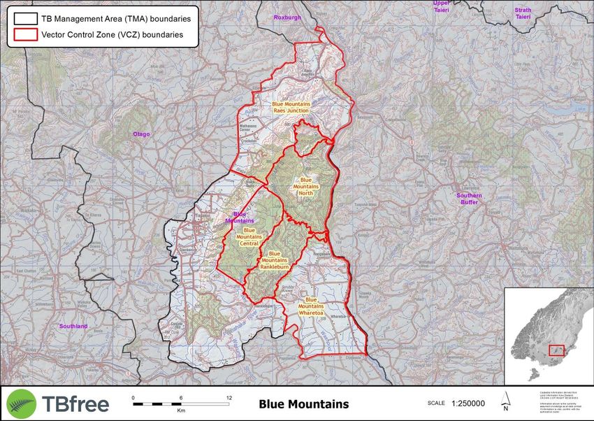
VERSION CONTROL

Version   Date         Details             Author

  1.0     30/11/2016   Final for release   Mark Lynch

                                           12 December 2016 | Page 2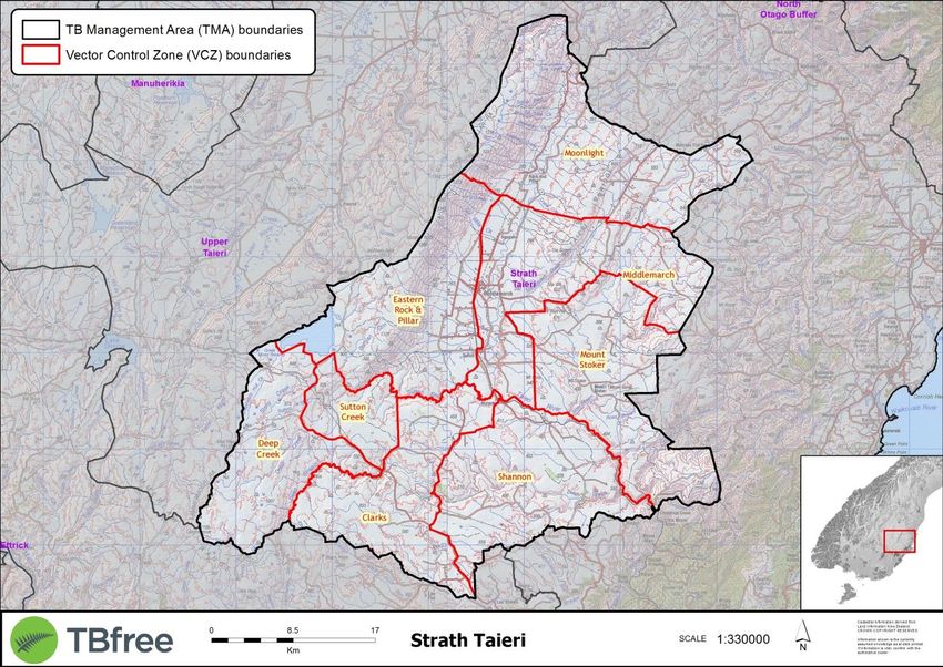
Contents
1 INTRODUCTION ............................................................................................................................................................ 4
2 DESCRIPTION OF VECTOR RISK AREAS .......................................................................................................................... 5
3 PLAN OBJECTIVES AND TARGETS .................................................................................................................................. 7
4 RISK MANAGEMENT ................................................................................................................................................... 10
5 TB MANAGEMENT AREA PLANS ................................................................................................................................. 11
5.1 Blue Mountains ........................................................................................................................................................ 13
5.2 Catlins ....................................................................................................................................................................... 15
5.3 Hokonui .................................................................................................................................................................... 17
5.4 Nevis ......................................................................................................................................................................... 19
5.5 Akatore - Tokomairiro .............................................................................................................................................. 21
5.6 Lindis ........................................................................................................................................................................ 23
5.7 Manuherikia ............................................................................................................................................................. 25
5.8 Morven-Bendigo....................................................................................................................................................... 27
5.9 North Otago Buffer................................................................................................................................................... 29
5.10 Upper Taieri.............................................................................................................................................................. 31
5.11 Timaru Creek ............................................................................................................................................................ 33
5.12 Wanaka-Hawea ........................................................................................................................................................ 35
5.13 Strath Taieri .............................................................................................................................................................. 37
5.14 East Otago ................................................................................................................................................................ 39
5.15 Southern Buffer ........................................................................................................................................................ 41
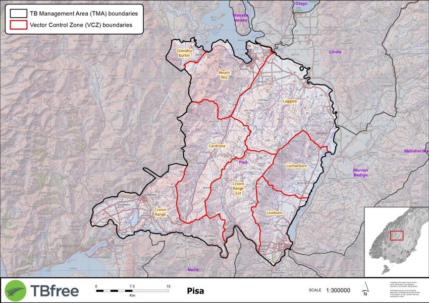
5.16 Pisa ........................................................................................................................................................................... 43
5.17 Roxburgh .................................................................................................................................................................. 45
5.18 South Canterbury South ........................................................................................................................................... 47
5.19 South Canterbury Core ............................................................................................................................................. 49
5.20 South Canterbury High Country ............................................................................................................................... 51
5.21 Western Southland................................................................................................................................................... 53
APPENDIX 1: GLOSSARY OF TERMS .............................................................................................................................. 55
12 December 2016 | Page 3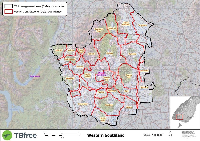
1     INTRODUCTION

Bovine tuberculosis (TB) is a disease of farmed cattle and deer in New Zealand which, if left to spread would lead to
production losses and animal health issues. This disease can also affect humans. Managing TB supports New Zealand’s
pastoral industries to increase productivity and access foreign markets – key elements of Government and industry
strategies. A healthy farming sector is a vital component of New Zealand’s economic wellbeing.

This document is the Area Disease Management Plan (ADMP) for the Southern South Island. The document provides details
on how the objectives that have been instructed as part of the National Operational Plan (NOP) will be met, and detailed
measurements that will be reported on to confirm TB freedom from livestock in New Zealand by 2026.

Area Disease Management Plans (ADMPs) are key components of the NPMP and the National Operational Plan (NOP), and
provide the operational planning framework for disease and pest management activities to be implemented at a regional
level.

The 2015 NPMP review found that TB can be eradicated from both farmed cattle and deer herds, and from wildlife species
(principally possums) that act as a reservoir and vector of the disease, and determined that eradication of TB from New
Zealand should be the overall long term objective of the National Pest Management Plan (NPMP).

The diagram below details the Statutory and Operational Hierarchy of the National Pest Management Plan, and highlights
that the ADMP is part of the Non Regulatory Framework of Operational Planning.

Figure 1: The Statutory and Operational hierarchy of the National Pest Management Plan.

                                                                                              12 December 2016 | Page 4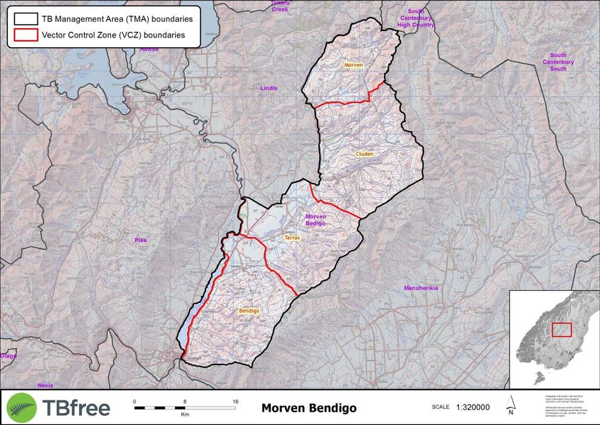
2    DESCRIPTION OF VECTOR RISK AREAS

There are 9 Vector Risk Areas (VRAs) contained within the Southern South Island which make up the area that will be
targeted for possum TB freedom as part of this Area Disease Management Plan’s objective:

Blue Mountains VRA (43,082ha)             Centred around the Blue Mountains in South Otago and lies immediately to the
                                          west of the Clutha River near Beaumont. This is the home of a nationally recognised
                                          fallow deer herd and is gazetted as a Recreational Hunting Area (RHA). The hills are
                                          moderate to rolling and covered in extensive stands of native or exotic forestry.
                                          The surrounding improved land is intensively farmed.

Catlins VRA (230,194ha)                   Situated near the south-eastern corner of the South Island, spanning both the Otago
                                          and Southland regions. The landscape is low to moderate rolling hill country with
                                          very significant stands of lowland native forest together with large areas of exotic
                                          forestry, scrub and improved farmland. This TMA can be considered as having a
                                          central core comprised of the Catlins and Chaslands forests and contiguous VCZ’s,
                                          and then an outer ring of VCZ’s that contain variable amounts of improved farmland,
                                          scrub and bush.

Hokonui Hills VRA (93,383ha)              Centred around the Hokonui Hills in Central Southland. It is comprised of large areas
                                          of native and exotic forestry surrounded by intensively farmed improved country.
                                          Possum habitat is plentiful and some is quite difficult to access.

Nevis VRA (77,319ha)                      Centred around the Nevis River catchment and extends the entire length of the Nevis
                                          valley. The landscape varies from flat to mountainous and is comprised of a mixture
                                          of tussock and scrub together with vast areas of little habitat in the upper reaches.

Otago VRA (1,469,717ha)                   The Otago VRA extends from Lakes Wanaka and Hawea in the north through to the
                                          east Otago coast, bounded to the south by the Clutha River system and to the north
                                          by the Kakanui Mountains. It is comprised of high country river valleys with a mixture
                                          of high country tussock, rock, scree and scrub in the Central Otago uplands and lakes
                                          districts, extensive farming through the Central Otago and Maniototo districts, and
                                          the more improved and intensively farmed areas in the Clutha Valley, East Otago and
                                          coastal Otago areas to the north.

Pisa VRA (126,703ha)                      Encompasses the Pisa and Criffel mountains that extend from Queenstown in the
                                          south through to Wanaka and Mt Roy in the northeast. The landscape is a mixture of
                                          high country tussock and scrub together with lowland improved farmland and
                                          supports a mixture of intensive and extensive farming.

Roxburgh VRA (6,595ha)                    Situated on the true right bank of the Clutha River and is centred adjacent to the
                                          Roxburgh hydro power station that spans the river. The landscape is comprised of a
                                          mixture of high country tussock and scrub together with areas of improved and
                                          intensively farmed land.

South Canterbury VRA (799,315ha)          Extends from the main divide in the north through to the south side of the Waitaki
                                          River system. It is comprised of high country river valleys with a mixture of high
                                          country tussock, rock, scree and scrub, extensive native forest ecosystems in some
                                          major valley systems, and a mixture of extensive farming and more improved and
                                          intensively farmed flats.

Western Southland VRA (144,492ha)         Centred around the southern Takitimu Mountains. There is a central core of rugged
                                          mountainous peaks with river valleys and extensive tracts of exotic and native bush.
                                          Outside of these areas there is a concentration of intensive farming on highly
                                          developed and improved land.

                                                                                                 12 December 2016 | Page 5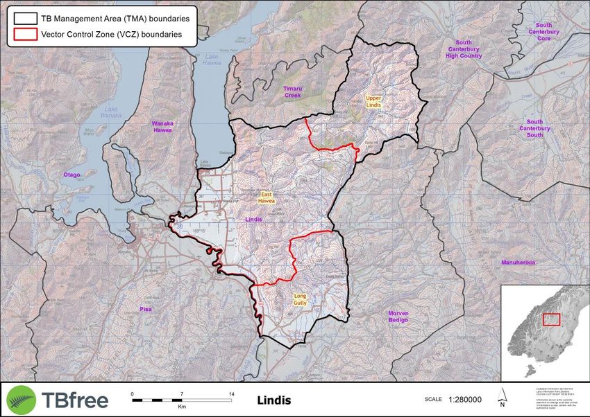
The Vector Risk Areas (VRAs) have been divided into TB Management Areas (TMAs).

Each TMA has an operational plan and objectives for TB freedom in livestock (if applicable) by 2026, possum TB freedom in
VRA by 2040 and biological eradication of TB from all livestock and wildlife by 2055.

The TMA structure enables possum control and disease surveillance to be contracted in an efficient manner utilising scales
of economy, while still maintaining areas at a manageable size in relation to the disease; i.e. similar methods of control and
surveillance can be used in an area. TMA therefore are contiguous areas with similar epidemiological and geographical
characteristics.

A TMA’s operational needs are such that the areas have an approximate planned target date for its eradication. When the
last TMA within the VRA reaches possum TB freedom, the VRA will have reached possum TB freedom.

                                                                                                  12 December 2016 | Page 6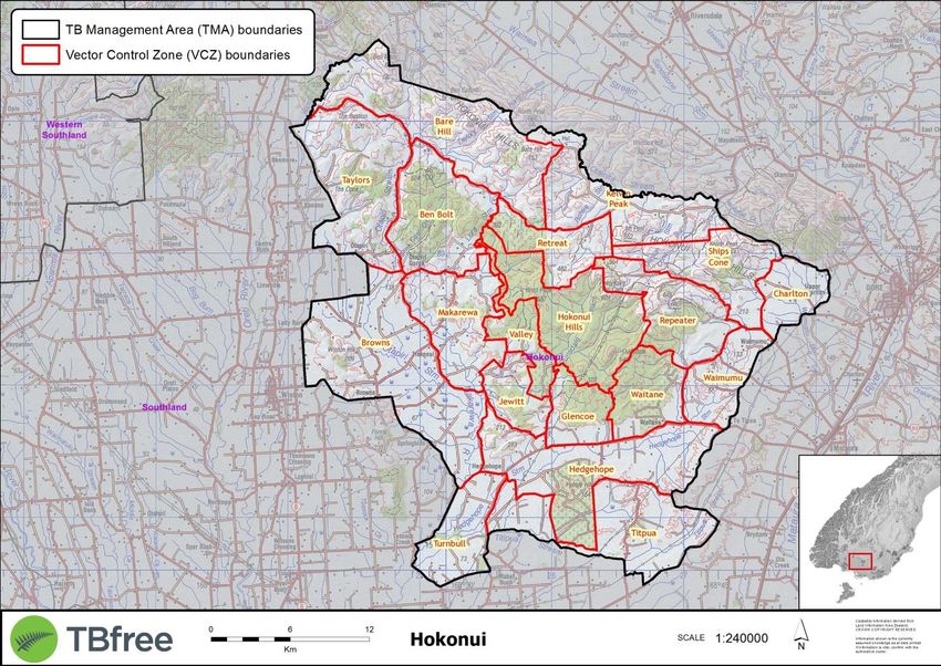
3     PLAN OBJECTIVES AND TARGETS

TB FREEDOM IN LIVESTOCK BY 2026

The first National Pest Management Plan (NPMP) primary objective milestone is to achieve TB freedom in domestic livestock
populations by 2026. While the term TB freedom is defined under clause 5(1A) of the Biosecurity (National Bovine
Tuberculosis Pest Management) Plan Order 1998, a proxy measure of the number of infected status herds will be used to
assess progress toward this milestone. The objectives for the infected herd reduction for the Southern South Island are
shown in Table 1.
Number of infected
                            2016        2017       2018       2019       2020       2021       2022       2023       2024     2025   2026
herds

Southern South Island         13         10         7           6          5          4          4          4             1    1      0

Table 1: Planned reduction of infected herds for the period 2016-2026, calculated at the commencement of the plan year.

TB FREEDOM IN POSSUMS BY 2040

The second primary objective milestone is to achieve TB freedom in possums by 2040. While the term TB freedom is
defined under clause 5(1A) of the (National Bovine Tuberculosis Pest Management) Plan Order 1998, a proxy measure of the
number of VRA hectares will be used for the second milestone. The objectives for VRA hectares reduction for the Southern
South Island are shown in Table 2.
Total VRA
(M hectares)                2016        2018       2020       2022       2024       2026       2028       2030       2032     2034   2036

Southern South Island        2.95       2.92       2.92     2.92         1.86       1.86       1.86       0.53        0.53    0.53   0.00

Table 2: Expected VRA reduction over the plan period 2016-2036, calculated at the commencement of the plan year.

                                                                                                                 12 December 2016 | Page 7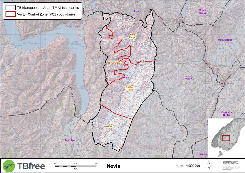
Map 1: Southern South Island Vector Risk Area/TB Management Area and planned timeframes for possum TB freedom 2016-2035

                                                                                                        12 December 2016 | Page 8
The table below shows the planned possum TB freedom timeframes for Southern South Island VRAs and associated TB
  Management Areas (TMAs).

  Each TMA will have a milestone date for the achievement of possum TB freedom.

  When the last TMA within the VRA reaches possum TB freedom, the VRA will have reached possum TB freedom.

           VRA Name              VRA Total Hectares               TMA Name                 TMA             TMA TB            VRA TB
                                                                                          Hectares        Freedom           Freedom
                                                                                            VRA             Date              Date
Blue Mountains                          43,084           Blue Mountains                    43,084            2026             2026

Catlins                                230,197           Catlins Southland                 60,557            2026             2026

                                                         Catlins Otago                     169,640           2026

Hokonui Hills                           27,184           Hokonui Hills                     27,184            2018             2018

Nevis                                   61,795           Nevis                             61,795            2026             2026

Otago                                 1,522,833          Lindis                            67,040            2026             2035

                                                         Akatore-Tokomairiro               63,082            2026

                                                         Manuherikia                       257,997           2030

                                                         Morven Bendigo                    81,660            2026

                                                         North Otago Buffer                44,152            2026

                                                         Upper Taieri                      268,279           2030

                                                         Timaru Creek                      11,907            2026

                                                         Wanaka-Hawea                      23,871            2026

                                                         Strath Taieri                     175,176           2030

                                                         East Otago                        180,894           2035

                                                         Southern Buffer                   348,775           2035

Pisa                                   126,704           Pisa                              126,704           2026             2026

Roxburgh                                 6,594           Roxburgh                           6,594            2024             2024

South Canterbury                       797,317           South Canterbury South            165,895           2024             2030

                                                         South Canterbury Core             399,380           2030

                                                         South Canterbury High
                                                                                           232,042           2030
                                                         Country

Western Southland                      131,494           Western Southland                 131,494           2026             2026

  Table 3: Planned possum TB freedom timeframes for Southern South Island Vector Risk Areas and associated TB management Areas.

                                                                                                              12 December 2016 | Page 9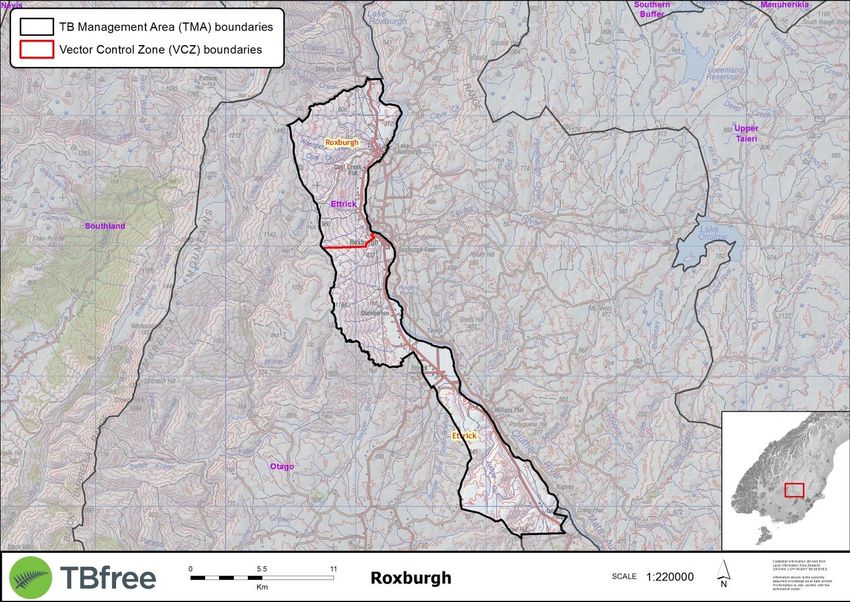
4 RISK MANAGEMENT
RISKS AT TB MANAGEMENT AREA LEVEL
Localised risks which could impact individual operations the Southern South Island include:
Landowner access issues due to 1080 – areas where individual landowners are potentially denying use of aerial
application of 1080 on their land and there are no other cost-effective means of controlling possums
Concerns from hunting groups - areas where there is a risk of non-target by-kill impacting on recreational activity
Geographical complexity– areas which due to their habitat/topography cause difficulties in the implementation of even
possum population reduction
Ferrets as a TB maintenance host- areas where ferrets can potentially self-sustain TB for extensive periods in the absence
of concurrent possum infection.
Specific details of relevant risks are contained within the individual TMA Plans, and a national risk profile can be viewed in
the National Operational Plan document.
Map 2: Southern South Island areas of localised risk.
12 December 2016 | Page 105 TB MANAGEMENT AREA PLANS
The Vector Risk Areas (VRAs) are made up of one or more TB Management Areas (TMAs).
Each TMA has an operational plan and objectives for TB freedom in livestock (if applicable), Tb freedom in possums, and the
total area of VRA reduction in hectares.
TMAs are areas with similar epidemiological and geographical characteristics which can enable wildlife control and disease
surveillance activities to be contracted in an efficient and cost effective manner. This allows utilising scales of economy
while still maintaining areas at a manageable size in relation to the disease, i.e. similar methods of control and surveillance
can be used in an area.
When the last TMA within the VRA achieves possum TB freedom, the VRA will have achieved VRA TB freedom.
TMAs themselves are made up of one of more Vector Control Zones (VCZs). Each VCZ will have a milestone date when
possum TB freedom is declared. This date will be determined when a predetermined probability-of-freedom (POF) from TB
in possums is reached for that VCZ.
When the last VCZ within a TMA achieves possum TB freedom, the TMA will have achieved VRA TB freedom.
The order of the TB Management Areas in this document follows the order that is shown in Table 3 on page 9. This allows
the reader to be able see the TMAs grouped within their respective Vector Risk Areas.
12 December 2016 | Page 11This page has been left blank intentionally
12 December 2016 | Page 125.1 BLUE MOUNTAINS
TB MANAGEMENT AREA OBJECTIVES
Possum TB freedom date: 2026
Herd TB freedom date: 2026
Total area of VRA reduction (hectares): 43,084
VCZ Name Hectares (VRA) Planned year of TB
freedom
Carsons 1,131 2026
Central 5,221 2026
North 6,617 2026
Raes Junction 14,583 2026
Rankleburn 4,715 2026
Wharetoa 10,817 2026
Total 43,084
DESCRIPTION OF TB MANAGEMENT AREA
The Blue Mountains TMA is centred around the Blue Mountains in South Otago and lie immediately to the west of the
Clutha River near Beaumont. This is the home of a nationally recognised fallow deer herd and is gazetted as a Recreational
Hunting Area (RHA). The hills are moderate to rolling and covered in extensive stands of native or exotic forestry. The
surrounding improved land is intensively farmed.
12 December 2016 | Page 13SUMMARY OF DISEASE AND VECTOR CONTROL HISTORY
TB was firmly established in wildlife in this area. Intensive aerial and ground based possum control was initiated in the
known infected areas from the late 1990’s and continued intermittently through until 2016. There are large areas that have
received relatively little possum control. Herds were infected near Beaumont, Raes Junction and at the southern end near
Rankleburn. There is no evidence that TB ever established on the west side near Tapanui.
PLANNED VECTOR RISK AREA REDUCTION
Blue Mountains 2016 2018 2020 2022 2024 2026 2028 2030 2032 2034 2036
Hectares 43,084 43,084 43,084 43,084 43,084 0 0 0 0 0 0
SUMMARY OF ACTIVITIES
Infected herd activities
There have been no infected herds for more than 5 years.
Summary of Operations Planned
Wildlife surveillance utilising feral pigs and ferrets will commence from 2016/17. It is planned to continue this activity for up
to 3 years (to achieve 95% POF) or until wildlife TB is detected. It is probable that TB still persists somewhere in this TMA and
for this reason possum TB freedom over the whole TMA is not expected before 2026. Targeted possum control will be
required to eradicate TB from any residual hotspots and follow-up wildlife surveillance required to confirm freedom. If TB
proves to be widespread, aerial control operations will be required.
Innovations, Initiatives and Research and Development
The Blue Mountains hunter liaison group was established more than 10 years ago. This has proven to be a very useful vehicle
for developing trust and cooperation between hunter groups and TBfree NZ over the years. It will remain an essential tool
whilst we work toward TB eradication.
RISK MANAGEMENT
Initial surveys in the early 2000’s indicated a very low prevalence of TB in fallow deer captured from the areas where the
highest numbers of TB possums were recovered. No TB infected deer have been reported since, even though the annual
hunter harvest is in the region of thousands of animals. It is not anticipated that deer will need to be targeted but this does
remain as a lower quadrant risk. Wildlife surveillance is expected to detect some TB areas representing residual TB in
possums and the use of deer repellent for any aerial operations will be essential to mitigate and placate the hunters.
SURVEILLANCE ACTIVITY 2040-2055 TO ACHIEVE BIOLOGICAL ERADICATION OF TB
Periodic pig and ferret surveys should be carried out post-TB freedom to confirm biological eradication.
12 December 2016 | Page 145.2 CATLINS
TB MANAGEMENT AREA OBJECTIVES
Possum TB freedom date: 2026
Herd TB freedom date: 2026
Total area of VRA reduction (hectares): 230,196
VCZ Name Hectares (VRA) Planned year of TB VCZ Name Hectares (VRA) Planned year of TB
freedom freedom
Catlins 24,542 2026 Owaka 1 14,898 2026
Chaslands 20,721 2026 Owaka 2 10,777 2022
Flamborough 3,449 2022 Progress Valley 7,559 2026
Glenham 7,562 2022 Redan 9,993 2022
Glenoamaru 8,363 2022 Romahapa 16,966 2022
Hina Hina 12,542 2026 Slopedown North 10,724 2022
Kaihiku 22,541 2022 Slopedown South 19,884 2026
Mimihau 2,991 2022 Tahakopa 7,682 2026
Mokoreta 6,525 2022 Venlaw 12,553 2022
Mouseback 5,531 2026 Waikawa 4,393 2026
Total 230,196
12 December 2016 | Page 15DESCRIPTION OF TB MANAGEMENT AREA
The Catlins TMA is situated near the south-eastern corner of the South Island, spanning both the Otago and Southland
regions. The landscape is low to moderate rolling hill country with very significant stands of lowland native forest together
with large areas of exotic forestry, scrub and improved farmland. This TMA can be considered as having a central core
comprised of the Catlins and Chaslands forests and contiguous VCZ’s, and then an outer ring of VCZ’s that contain variable
amounts of improved farmland, scrub and bush.
SUMMARY OF DISEASE AND VECTOR CONTROL HISTORY
TB was established in wildlife through many parts of this TMA for many years. Intensive aerial and ground based possum
control was initiated in the known infected areas from the late 1990’s and continued intermittently through until 2016. At
the peak there were up to 100 infected herds in this TMA at one time.
PLANNED VECTOR RISK AREA REDUCTION
Catlins 2016 2018 2020 2022 2024 2026 2028 2030 2032 2034 2036
Hectares 230,196 230,196 230,196 117,752 117,752 0 0 0 0 0 0
SUMMARY OF ACTIVITIES
Infected herd activities
There have been no infected herds for more than 5 years.
Summary of Operations Planned
In the central core region (Chaslands and Catlins forests), a “survey then control” (STC) aerial operation, along the lines of
that completed in the Hokonui Hills, is planned for 2017/18. Following the STC operation, wildlife surveillance utilising feral
pigs will commence in 2018/19 for two years. TBfree sentinel pigs may be used depending on the success of this technique
in the Hokonui Hills. Proof of freedom pig and/or ferret surveys will be carried out concurrently in the outer VCZ’s of the
TMA from 2016/17 for two years. Output-based possum control will continue in the inner VCZs adjacent to the aerial blocks
for up to three years from 2016/17, including surveying possums from the historical hotspot areas. It is planned to continue
with wildlife surveillance for up to 5 years (to achieve 95% POF) or until wildlife TB is detected. It is probable that TB still
persists somewhere in this TMA and for this reason possum TB freedom over the whole TMA is not expected before 2026.
Innovations, Initiatives and Research and Development
There will be one further aerial operation using the “survey then control” methodology. TBfree sentinel pigs may be used for
post control surveillance if the technique proves successful in the Hokonui Hills.
RISK MANAGEMENT
This TMA is very large and contains extensive areas of remote prime possum habitat. This was one of the most badly
infected areas in New Zealand as recently as 15 years ago. There is a moderate risk of TB persistence even after the planned
“STC” aerial operation and associated ground control. However the target of zero infected herds is not seriously at risk but
rather the projected date for freedom in possums of 2026.
SURVEILLANCE ACTIVITY 2040-2055 TO ACHIEVE BIOLOGICAL ERADICATION OF TB
Periodic pig and ferret surveys should be carried out post-TB freedom to confirm biological eradication.
12 December 2016 | Page 165.3 HOKONUI HILLS
TB MANAGEMENT AREA OBJECTIVES
Possum TB freedom date: 2018
Herd TB freedom date: 2016
Total area of VRA reduction (hectares): 27,184
VCZ Name Hectares (VRA) Planned year of
TB freedom
Ben Bolt 5,663 2018
Glencoe 2,314 2018
Hokonui Hills 6,567 2018
Repeater 4,520 2018
Retreat 2,933 2018
Valley 2,088 2018
Waitane 3,099 2018
Total 27,184
DESCRIPTION OF TB MANAGEMENT AREA
The Hokonui TMA is centred around the Hokonui Hills in Central Southland. It is comprised of large areas of native and exotic
forestry surrounded by intensively farmed improved country. Possum habitat is plentiful and some is quite difficult to
access.
12 December 2016 | Page 17SUMMARY OF DISEASE AND VECTOR CONTROL HISTORY
TB was established in wildlife throughout this TMA for many years. Possum control was intermittent during the period
1980-2000. Beginning in 2002 intensive aerial and ground based possum control commenced and has continued through
until 2016. The final wildlife surveillance phase will be completed by 2018 using TBfree sentinel pigs and resident pigs. It is
expected that this TMA will be declared free by 2018.
PLANNED VECTOR RISK AREA REDUCTION
Hokonui 2016 2018 2020 2022 2024 2026 2028 2030 2032 2034 2036
Hectares 27,184 0 0 0 0 0 0 0 0 0 0
SUMMARY OF ACTIVITIES
Infected Herd Activities
There are currently no infected herds in this TMA.
Summary of Operations Planned
Final POF wildlife surveillance commenced during 2015/16 using TB free sentinel pigs. This is expected to continue through
until 2017/18 and local pigs will also be surveyed in the latter stages.
Innovations, Initiatives and Research and Development
TBfree sentinel pig programme.
RISK MANAGEMENT
This TMA has a very long history of wildlife associated TB. Final POF is likely to be in the order of 95% probability so there is a
low, but manageable, risk of residual infection still being present in wildlife.
SURVEILLANCE ACTIVITY 2040-2055 TO ACHIEVE BIOLOGICAL ERADICATION OF TB
Post-TB freedom wildlife surveillance should be undertaken at 5 year intervals for at least 10 years after possum TB freedom
is declared.
12 December 2016 | Page 185.4 NEVIS
TB MANAGEMENT AREA OBJECTIVES
Possum TB freedom date: 2026
Herd TB freedom date: 2026
Total area of VRA reduction (hectares): 61,795
VCZ Name Hectares (VRA) Planned year of
TB freedom
Horn Range 22,920 2026
Remarkables 12,021 2026
Southern Nevis 26,854 2026
Total 61,795
DESCRIPTION OF TB MANAGEMENT AREA
The Nevis TMA is centred around the Nevis River catchment and extends the entire length of the Nevis valley. The landscape
varies from flat to mountainous and is comprised of a mixture of tussock and scrub together with vast areas of little habitat
in the upper reaches.
SUMMARY OF DISEASE AND VECTOR CONTROL HISTORY
TB was established in wildlife in the lower reaches of the Nevis Valley and the Gibbston Flats for many years and still is.
Ferrets inhabit this area and infection was previously common. There are few herds but infection did occur sporadically.
12 December 2016 | Page 19PLANNED VECTOR RISK AREA REDUCTION
Nevis 2016 2018 2020 2022 2024 2026 2028 2030 2032 2034 2036
Hectares 61,795 61,795 61,795 61,795 61,795 0 0 0 0 0 0
SUMMARY OF ACTIVITIES
Infected Herd Activities
There are currently no infected herds in this TMA.
Summary of Operations Planned
Further output-based possum control is required in the Horn Range VCZ for at least the next three years (2016/17-2018/19).
In the Southern Nevis and Remarkables VCZs, wildlife surveillance using ferrets and possums (commencing in 2017/18) will
be used to help identify areas where TB may be persisting in possums. Data gathered will be progressively analysed using
the POF modelling software until 95% confidence of possum TB freedom is reached or until TB is detected in wildlife. Should
TB be detected and considered to represent ongoing TB infection in possums further intensive and targeted possum control
will be required.
Innovations, Initiatives and Research and Development
Use of broad scale wildlife surveys to assist in residual TB possum hotspot detection.
RISK MANAGEMENT
The SSI is embarking on large-scale ferret and pig surveillance programme throughout virtually all of the drylands from South
Canterbury to Central Otago. These areas have received variable amounts of possum control over the years and TB will be
well suppressed in many areas and may well be eradicated from others. It is now appropriate to seek out residual possum
hotspots so that any future control can be targeted as broad scale control can no longer be justified. Given the size of the
areas involved, their chronic history of wildlife infection and the sporadic nature of possum control, it is certain that TB will
be detected in the wildlife surveys. If infection is widespread, the cost of future possum control through to eradication will
be substantial. It is estimated that at least 50% of the area included in the drylands wildlife surveillance programme will
require further targeted possum control of some sort. This is manageable within projected budgets.
There is also the risk that TB is discovered to be self-sustaining within high-density ferret populations within the TMA,
necessitating ferret control to be undertaken at some stage within the first 10 years of the NPMP.
SURVEILLANCE ACTIVITY 2040-2055 TO ACHIEVE BIOLOGICAL ERADICATION OF TB
Post-TB freedom wildlife surveillance should be undertaken 5 years after possum TB Freedom is declared but this should be
focussed on the historical hotspots of Gibbston and the lower Nevis Valley.
12 December 2016 | Page 205.5 AKATORE - TOKOMAIRIRO
TB MANAGEMENT AREA OBJECTIVES
VRA TB freedom date: 2026
Herd TB freedom date: 2026
Total area of VRA reduction (hectares): 63,082
VCZ Name Hectares (VRA) Planned year of
TB freedom
Akatore 27,457 2026
Brighton 13,793 2026
Lake Tuakitoto 3,766 2018
Toko – Kai 18,066 2026
Total 63,082
DESCRIPTION OF TB MANAGEMENT AREA
The Akatore-Tokomairiro TMA is the eastern coastal section of the Otago VRA and extends from the Clutha River in the
south to Dunedin City in the north. The landscape is predominantly rolling hill country with a mixture of significant exotic
forestry stands, broken native bush remnants, cleared and improved farmland and lifestyle blocks.
12 December 2016 | Page 21SUMMARY OF DISEASE AND VECTOR CONTROL HISTORY
TB was firmly established in wildlife in this area. Intensive aerial and ground based possum control was initiated from the
late 1990’s and continued intermittently through until 2011. Many herds were infected during the 1990-2000 period.
PLANNED VECTOR RISK AREA REDUCTION
Akatore-
2016 2018 2020 2022 2024 2026 2028 2030 2032 2034 2036
Tokomairiro
Hectares 63,082 59,316 59,316 59,316 59,316 0 0 0 0 0 0
SUMMARY OF ACTIVITIES
Infected Herd Activities
There have been no infected herds for more than 5 years.
Summary of Operations Planned
Wildlife surveillance utilising feral pigs and/or ferrets commences early in 2016/17. It is planned to continue this activity for
up to 3 years (to achieve 95% POF) or until wildlife TB is detected. It is probable that TB still persists somewhere in some
parts of this TMA and for this reason possum TB freedom over the whole TMA is not expected before 2026. Targeted
possum control will be required to eradicate TB from any residual hotspots and follow-up wildlife surveillance required to
confirm freedom.
Innovations, Initiatives and Research and Development
Not required.
RISK MANAGEMENT
A feral horse herd is known to exist within the TMA which may create complications for any proposed control and/or
surveillance activity.
SURVEILLANCE ACTIVITY 2040-2055 TO ACHIEVE BIOLOGICAL ERADICATION OF TB
Periodic pig and ferret surveys should be carried out post-TB freedom in possums to confirm biological eradication.
12 December 2016 | Page 225.6 LINDIS
TB MANAGEMENT AREA OBJECTIVES
Possum TB freedom date: 2026
Herd TB freedom date: 2026
Total area of VRA reduction (hectares): 67,040
VCZ Name Hectares (VRA) Planned year of
TB freedom
Easy Hawea 35,280 2026
Long Gully 14,226 2026
Upper Lindis 17,534 2026
Total 67,040
DESCRIPTION OF TB MANAGEMENT AREA
The Lindis TMA extends from Lake Hawea and Tarras in the south to the top of the Lindis Pass in the north. The landscape
varies from flat to mountainous and contains a mixture of tussock and scrub together with improved farmland that supports
intensive and extensive farming.
SUMMARY OF DISEASE AND VECTOR CONTROL HISTORY
TB was established in wildlife throughout this TMA for many years. Ferrets and feral pigs are widely distributed and
infection was previously common. Herds were also frequently infected.
12 December 2016 | Page 23PLANNED VECTOR RISK AREA REDUCTION
Lindis 2016 2018 2020 2022 2024 2026 2028 2030 2032 2034 2036
Hectares 67,040 67,040 67,040 67,040 67,040 0 0 0 0 0 0
SUMMARY OF ACTIVITIES
Infected Herds Activity
There are currently no infected herds in this TMA.
Summary of Operations Planned
Wildlife surveillance using ferrets and/or feral pigs will be used over at least the next three years (2016/17-2018/19) to help
identify areas where TB may be persisting in possums. Data gathered will be progressively analysed using the POF modelling
software until 95% confidence of possum TB freedom is reached or until TB is detected in wildlife. Should TB be detected
and considered to represent ongoing TB infection in possums further intensive and targeted possum control will be
required.
INNOVATIONS, INITIATIVES AND RESEARCH AND DEVELOPMENT
Use of broad scale wildlife surveys to assist in residual TB possum hotspot detection.
RISK MANAGEMENT
The SSI is embarking on large-scale ferret and pig surveillance programme throughout virtually all of the drylands from South
Canterbury to Central Otago. These areas have received variable amounts of possum control over the years and TB will be
well suppressed in many areas and may well be eradicated from others. It is now appropriate to seek out residual possum
hotspots so that any future control can be targeted as broad scale control can no longer be justified. Given the size of the
areas involved, their chronic history of wildlife infection and the sporadic nature of possum control, it is certain that TB will
be detected in the wildlife surveys. If infection is widespread, the cost of future possum control through to eradication will
be substantial. It is estimated that at least 50% of the area included in the drylands wildlife surveillance programme will
require further targeted possum control of some sort. This is manageable within projected budgets.
There is also the risk that TB is discovered to be self-sustaining within high-density ferret populations within the TMA,
necessitating ferret control to be undertaken at some stage within the first 10 years of the NPMP.
SURVEILLANCE ACTIVITY 2040-2055 TO ACHIEVE BIOLOGICAL ERADICATION OF TB
Post TB-freedom wildlife surveillance should be undertaken 5 years after possum TB freedom is declared.
12 December 2016 | Page 245.7 MANUHERIKIA
TB MANAGEMENT AREA OBJECTIVES
Possum TB freedom date: 2030
Herd TB freedom date: 2026
Total area of VRA reduction (hectares): 257,997
VCZ Name Hectares (VRA) Planned year of TB VCZ Name Hectares (VRA) Planned of TB
freedom freedom
Chatto Creek 15,514 2030 Pennyweight Hills 20,891 2030
Clare Hills 11,173 2030 Poolburn 20,639 2030
Dunstan Creek 12,250 2030 Raggedy 27,090 2030
Ida Valley 24,193 2030 Rocky Peak 18,864 2030
Leaning Rock 12,542 2030 St Bathans 25,034 2030
Moa Creek 17,783 2030 Thompsons Gorge 18,242 2030
North Rough Ridge 12,474 2030 Upper 21,308 2030
Manuherikia
Total 257,997
DESCRIPTION OF TB MANAGEMENT AREA
12 December 2016 | Page 25The Manuherikia TMA includes the Manuherikia River catchment from its source in the St Bathans mountains to its junction
with the Clutha River at Alexandra and the adjacent Ida Valley. It varies from flat to mountainous and is comprised of a
mixture of tussock and scrub together with improved farmland that supports intensive and extensive farming.
SUMMARY OF DISEASE AND VECTOR CONTROL HISTORY
TB was established in wildlife throughout this TMA for many years. Ferrets and feral pigs are widely distributed and
infection was previously common. Herds were also frequently infected.
PLANNED VECTOR RISK AREA REDUCTION
Manuherikia 2016 2018 2020 2022 2024 2026 2028 2030 2032 2034 2036
Hectares 257,997 257,997 257,997 257,997 257,997 257,997 257,997 0 0 0 0
SUMMARY OF ACTIVITIES
Infected Herd Activity
There are currently no infected herds in this TMA.
Summary of Operations Planned
Wildlife surveillance using ferrets and feral pigs will be used over at least the next three years (2016/17-2018/19) to help
identify areas where TB may be persisting in possums. Data gathered will be progressively analysed using the POF modelling
software until 95% confidence of possum TB freedom is reached or until TB is detected in wildlife. Should TB be detected
and considered to represent ongoing TB infection in possums further intensive and targeted possum control will be
required.
Innovations, Initiatives and Research and Development
Use of broad scale wildlife surveys to assist in residual TB possum hotspot detection.
RISK MANAGEMENT
The SSI is embarking on large-scale ferret and pig surveillance programme throughout virtually all of the drylands from South
Canterbury to Central Otago. These areas have received variable amounts of possum control over the years and TB will be
well suppressed in many areas and may well be eradicated from others. It is now appropriate to seek out residual possum
hotspots so that any future control can be targeted as broad scale control can no longer be justified. Given the size of the
areas involved, their chronic history of wildlife infection and the sporadic nature of possum control, it is certain that TB will
be detected in the wildlife surveys. If infection is widespread, the cost of future possum control through to eradication will
be substantial. It is estimated that at least 50% of the area included in the drylands wildlife surveillance programme will
require further targeted possum control of some sort. This is manageable within projected budgets.
There is also the risk that TB is discovered to be self-sustaining within high-density ferret populations within the TMA,
necessitating ferret control to be undertaken at some stage within the first 10 years of the NPMP.
SURVEILLANCE ACTIVITY 2040-2055 TO ACHIEVE BIOLOGICAL ERADICATION OF TB
Post-TB freedom wildlife surveillance should be undertaken 5 years after possum TB freedom is declared.
12 December 2016 | Page 265.8 MORVEN-BENDIGO
TB MANAGEMENT AREA OBJECTIVES
Possum TB freedom date: 2026
Herd TB freedom date: 2026
Total area of VRA reduction (hectares): 81,660
VCZ Name Hectares (VRA) Planned year of
TB freedom
Bendigo 22,281 2026
Cluden 25,643 2026
Morven 13,578 2026
Tarras 20,158 2026
Total 81,660
DESCRIPTION OF TB MANAGEMENT AREA
The Morven-Bendigo TMA includes the western faces of the Dunstan Mountains near Cromwell and extends up the eastern
side of the Lindis Pass highway to the Lindis Pass summit. It is comprised of a mixture of tussock and scrub together with
improved farmland that supports both intensive and extensive farming.
SUMMARY OF DISEASE AND VECTOR CONTROL HISTORY
TB was established in wildlife throughout this TMA for many years. Ferrets and feral pigs are widely distributed and
infection was previously common. Herds were also frequently infected.
12 December 2016 | Page 27PLANNED VECTOR RISK AREA REDUCTION
Morven-
2016 2018 2020 2022 2024 2026 2028 2030 2032 2034 2036
Bendigo
Hectares 81,660 81,660 81,660 81,660 81,660 0 0 0 0 0 0
SUMMARY OF ACTIVITIES
Infected Herd Activities
There are currently no infected herds in this TMA.
Summary of Operations Planned
Wildlife surveillance using ferrets and feral pigs will be used over at least the next three years (2016/17-2018/19) to help
identify areas where TB may be persisting in possums. Data gathered will be progressively analysed using the POF modelling
software until 95% confidence of possum TB freedom is reached or until TB is detected in wildlife. Should TB be detected
and considered to represent ongoing TB infection in possums further intensive and targeted possum control will be
required.
Innovations, Initiatives and Research and Development
Use of broad scale wildlife surveys to assist in residual TB possum hotspot detection.
RISK MANAGEMENT
The SSI is embarking on large-scale ferret and pig surveillance programme throughout virtually all of the drylands from South
Canterbury to Central Otago. These areas have received variable amounts of possum control over the years and TB will be
well suppressed in many areas and may well be eradicated from others. It is now appropriate to seek out residual possum
hotspots so that any future control can be targeted as broad scale control can no longer be justified. Given the size of the
areas involved, their chronic history of wildlife infection and the sporadic nature of possum control, it is certain that TB will
be detected in the wildlife surveys. If infection is widespread, the cost of future possum control through to eradication will
be substantial. It is estimated that at least 50% of the area included in the drylands wildlife surveillance programme will
require further targeted possum control of some sort. This is manageable within projected budgets.
There is also the risk that TB is discovered to be self-sustaining within high-density ferret populations within the TMA,
necessitating ferret control to be undertaken at some stage within the first 10 years of the NPMP.
SURVEILLANCE ACTIVITY 2040-2055 TO ACHIEVE BIOLOGICAL ERADICATION OF TB
Post-TB freedom wildlife surveillance should be undertaken 5 years after possum TB freedom is declared.
12 December 2016 | Page 285.9 NORTH OTAGO BUFFER
TB MANAGEMENT AREA OBJECTIVES
Possum TB freedom date: 2026
Herd TB freedom date: 2026
Total area of VRA reduction (hectares): 44,152
VCZ Name Hectares (VRA) Planned year of
TB freedom
Hampden 3,343 2026
Moeraki 15,008 2026
Mt Stalker 25,801 2026
Total 44,152
DESCRIPTION OF TB MANAGEMENT AREA
The North Otago Buffer TMA is the last line of defence between the Otago VRA and the vector free areas to the north and
northeast. It extends from the coast near Moeraki and along the eastern flank of the Kakanui Mountains towards Danseys
Pass. The landscape varies from flat to mountainous and the habitat ranges from improved and intensively farmed through
to extensive tussock and large areas of native and exotic forest.
SUMMARY OF DISEASE AND VECTOR CONTROL HISTORY
TB was established in this TMA in the 1990’s. Possum control started in the adjacent VFA early in the 2000’s to prevent TB
spreading further and the VRA VCZ’s were controlled for possums in subsequent years as funding allowed. Control has been
frequent including repeat aerial operations. There has been the occasional infected herd.
12 December 2016 | Page 29PLANNED VECTOR RISK AREA REDUCTION
North Otago
2016 2018 2020 2022 2024 2026 2028 2030 2032 2034 2036
Buffer
Hectares 44,152 44,152 44,152 44,152 44,152 0 0 0 0 0 0
SUMMARY OF ACTIVITIES
Infected Herd Activities
There are currently no infected herds in this TMA.
Summary of Operations Planned
This TMA is strategically important as a buffer between the TB VRA and the intensively farmed VFA towards the Waitaki
River to the north. The ground strata associated with Mt Stalker, Hampden and Moeraki VCZ’s are programmed for output-
based possum control for 2017/18, 2018/19 and 2019/20. The Mt Stalker aerial strata has control programmed for winter
2017 and the aerial strata of Moeraki is programmed for control in the winter of 2019.
A recent pig survey from Danseys to Mt Stalker provided reassurance that TB was not established in the VFA to the north.
Given the importance of this buffer being effective, ferret and/or pig surveys will be repeated in the adjacent VFA in 2016/17
and, depending on the results, may be repeated in 2018/19.
Innovations, Initiatives and Research and Development
Nothing specific to this VCZ.
RISK MANAGEMENT
This TMA is strategically important as a buffer between the TB VRA and the intensively farmed VFA to the north. There is an
ongoing risk that TB possums could spread north into the VFA section of this TMA until the internal VRA is sustainably
controlled. This would trigger repetitive possum control over very large areas of difficult terrain. Emphasis is being placed on
providing sustained control in the core to mitigate this risk as soon as possible. In addition, pig surveys have, and will, be
conducted to check for any possible spread as the herd testing surveillance is low.
SURVEILLANCE ACTIVITY 2040-2055 TO ACHIEVE BIOLOGICAL ERADICATION OF TB
Post-TB freedom wildlife surveillance should be undertaken 5 and 10 years after possum TB freedom is declared.
12 December 2016 | Page 305.10 UPPER TAIERI
TB MANAGEMENT AREA OBJECTIVES
VRA TB freedom date: 2030
Herd TB freedom date: 2026
Total area of VRA reduction (hectares): 268,279
VCZ Name Hectares (VRA) Planned year of VCZ Name Hectares (VRA) Planned year of
TB freedom TB freedom
Gimmerburn 28,964 2030 Patearoa 20,961 2030
Greenland 23,847 2022 Ranfurly 19,494 2030
Hogburn 13,905 2030 Styx 20,359 2030
Houndburn 20,311 2030 Upper Taieri 14,230 2022
Lake Onslow 16,384 2022 Wedderburn 14,236 2030
Loganburn 16,217 2030 West Kaknui 21,081 2030
Naseby 20,447 2030 W. Rock and Pillar 17,843 2030
Total 268,279
DESCRIPTION OF TB MANAGEMENT AREA
The Upper Taieri TMA encompasses the Taieri River catchment from its source in the Lammerlaw Range through to the top
of the Pigroot. It is comprised of a mixture of high country tussock and scrub together with improved farmland and supports
a mixture of intensive and extensive farming.
12 December 2016 | Page 31SUMMARY OF DISEASE AND VECTOR CONTROL HISTORY
TB was established in wildlife throughout this TMA for many years and still is. Ferrets and feral pigs are widely distributed
and infection was previously common. Herds were also frequently infected.
PLANNED VECTOR RISK AREA REDUCTION
Upper Taieri 2016 2018 2020 2022 2024 2026 2028 2030 2032 2034 2036
Hectares 268,279 268,279 268,279 213,818 213,818 213,818 213,818 0 0 0 0
SUMMARY OF ACTIVITIES
Infected Herd Activities
There is currently 1 infected herd in this TMA and infection is due to local wildlife. Standard management techniques are
expected to clear this herd in the short term.
Summary of Operations Planned
Wildlife surveillance using ferrets and feral pigs will be used over at least the next three years (2016/17-2018/19) to help
identify areas where TB may be persisting in possums. Data gathered will be progressively analysed using the POF modelling
software until 95% confidence of possum TB freedom is reached or until TB is detected in wildlife. Should TB be detected
and considered to represent ongoing TB infection in possums further intensive and targeted possum control will be
required.
Innovations, Initiatives and Research and Development
Use of broad scale wildlife surveys to assist in residual TB possum hotspot detection.
RISK MANAGEMENT
The SSI is embarking on large-scale ferret and pig surveillance programme throughout virtually all of the drylands from South
Canterbury to Central Otago. These areas have received variable amounts of possum control over the years and TB will be
well suppressed in many areas and may well be eradicated from others. It is now appropriate to seek out residual possum
hotspots so that any future control can be targeted as broad scale control can no longer be justified. Given the size of the
areas involved, their chronic history of wildlife infection and the sporadic nature of possum control, it is certain that TB will
be detected in the wildlife surveys. If infection is widespread, the cost of future possum control through to eradication will
be substantial. It is estimated that at least 50% of the area included in the drylands wildlife surveillance programme will
require further targeted possum control of some sort. This is manageable within projected budgets.
There is also the risk that TB is discovered to be self-sustaining within high-density ferret populations within the TMA,
necessitating ferret control to be undertaken at some stage within the first 10 years of the NPMP.
SURVEILLANCE ACTIVITY 2040-2055 TO ACHIEVE BIOLOGICAL ERADICATION OF TB
Post-TB freedom wildlife surveillance should be undertaken 5 years after possum TB freedom is declared.
12 December 2016 | Page 325.11 TIMARU CREEK
TB MANAGEMENT AREA OBJECTIVES
VRA TB freedom date: 2026
Herd TB freedom date: 2026
Total area of VRA reduction (hectares): 11,907
VCZ Name Hectares (VRA) Planned year of
TB freedom
Timaru Creek 3,377 2026
Upper Timaru Creek 8,530 2026
Total 11,907
DESCRIPTION OF TB MANAGEMENT AREA
The Timaru Creek TMA is situated on the north eastern shore of Lake Hawea and is centred around the Timaru Creek
catchment. It is the last line of defence between the Otago VRA and the VFA. It is a tight mountainous river valley with
extensive habitat throughout much of its length.
SUMMARY OF DISEASE AND VECTOR CONTROL HISTORY
TB was well established in this TMA and still is. While there is little stock grazing available, the cattle herds on either side of
Timaru Creek have been infected. TB ferrets and pigs have recently been detected on the south eastern side.
12 December 2016 | Page 33PLANNED VECTOR RISK AREA REDUCTION
Timaru
2016 2018 2020 2022 2024 2026 2028 2030 2032 2034 2036
Creek
Hectares 11,907 11,907 11,907 11,907 11,907 0 0 0 0 0 0
SUMMARY OF ACTIVITIES
Infected Herd Activities
There are currently no infected herds in this TMA.
Summary of Operations Planned
Further output-based possum control is required in the Timaru Creek VCZ for at least the next three years (2016/17-
2018/19). Targeted and trickle aerial control completed in the last two years covers only part of the area now identified as
being at risk. An aerial operation will be needed in the Timaru Creek VCZ within the next three years. Ferret and pig surveys
will be undertaken in the Upper Timaru Creek VCZ for at least the next three years (2016/17-2018/19). Ferret surveys in the
adjacent VFA from Timaru Creek to the Dingleburn will be undertaken every two years.
Innovations, Initiatives and Research and Development
Nothing specific to this VCZ.
RISK MANAGEMENT
TB wild animals still persist in this TMA and it is the last line of defence between the VRA and the VFA at this point. Further
intensive possum control, including a possible aerial operation, is planned and the VFA ferret survey from Timaru Creek to
the Dingleburn will be regularly repeated.
SURVEILLANCE ACTIVITY 2040-2055 TO ACHIEVE BIOLOGICAL ERADICATION OF TB
Post-TB freedom wildlife surveillance should be undertaken 5 and 10 years after possum TB freedom is declared.
12 December 2016 | Page 345.12 WANAKA-HAWEA
TB MANAGEMENT AREA OBJECTIVES
VRA TB freedom date: 2026
Herd TB freedom date: 2026
Total area of VRA reduction (hectares): 23,871
VCZ Name Hectares (VRA) Planned year of
TB freedom
Hawea Neck 3,218 2026
Wanaka Hawea 20,653 2026
Total 23,871
DESCRIPTION OF TB MANAGEMENT AREA
The Wanaka-Hawea TMA is situated between Lake Wanaka and Lake Hawea. TB was established here and several cattle and
deer herds were infected. The habitat is extensive, rough and high with vegetation of most types from scrub through to
extensive native beech stands. There is also a significant amount of improved pasture that is intensively farmed.
SUMMARY OF DISEASE AND VECTOR CONTROL HISTORY
TB probably never established in possums in the Hawea Neck VCZ but it was certainly close by in the much larger and
rougher Wanaka-Hawea VCZ. Vector control has been intensive and sustained in this TMA for many years due to its
proximity to the VFA of Makarora and Mt Aspiring National Park to the northwest.
12 December 2016 | Page 35PLANNED VECTOR RISK AREA REDUCTION
Wanaka-
2016 2018 2020 2022 2024 2026 2028 2030 2032 2034 2036
Hawea
Hectares 23,871 23,871 23,871 23,871 23,871 0 0 0 0 0 0
SUMMARY OF ACTIVITIES
Infected Herd Activities
There are currently no infected herds in this TMA.
Summary of Operations Planned
Wildlife surveillance using ferrets and feral pigs will be undertaken in the Wanaka Hawea VCZ for at least the next three
years (2016/17-2018/19) to help identify areas where TB may be persisting in possums. Data gathered will be progressively
analysed using the POF modelling software until 95% confidence of TB freedom is reached or until TB is detected in wildlife.
Should TB be detected and considered to represent ongoing TB infection in possums further intensive and targeted possum
control, possibly aerial, will be required. Further output-based possum control is required in the Hawea Neck VCZ for at least
the next three years (2016/17-2018/19), as a buffering strategy, until there is confidence of TB freedom in possums in the
Wanaka Hawea VCZ.
Innovations, Initiatives and Research and Development
Nothing specific to this VCZ.
RISK MANAGEMENT
This is the last line of defence between the VRA and the VFA at this point. The buffer strategy will need to be maintained
until there is confidence of TB freedom in possums within the TMA.
SURVEILLANCE ACTIVITY 2040-2055 TO ACHIEVE BIOLOGICAL ERADICATION OF TB
Post-TB freedom wildlife surveillance should be undertaken 5 and 10 years after possum TB freedom is declared and just
limited to the Wanaka-Hawea VCZ.
12 December 2016 | Page 365.13 STRATH TAIERI
TB MANAGEMENT AREA OBJECTIVES
VRA TB freedom date: 2030
Herd TB freedom date: 2026
Total area of VRA reduction (hectares): 175,176
VCZ Name Hectares (VRA) Planned year of TB
freedom
Clarks 19,942 2030
Deep Creek 17,780 2030
E. Rock and Pillar 25,723 2030
Middlemarch 24,945 2030
Moonlight 31,319 2030
Mt Stoker 24,973 2030
Shannon 23,564 2030
Sutton 6,930 2030
Total 175,176
12 December 2016 | Page 37DESCRIPTION OF TB MANAGEMENT AREA
The Strath Taieri TMA covers the drylands inland from Dunedin, around Middlemarch and the eastern faces of the Rock and
Pillar Ranges through towards the Pigroot in the northeast. It is comprised of a mixture of tussock and scrub together with
improved farmland and supports a mixture of intensive and extensive farming.
SUMMARY OF DISEASE AND VECTOR CONTROL HISTORY
TB was established in wildlife throughout this TMA for many years and still is. Ferrets and feral pigs are widely distributed
and infection was previously common. Herds were also frequently infected.
PLANNED VECTOR RISK AREA REDUCTION
Strath Taieri 2016 2018 2020 2022 2024 2026 2028 2030 2032 2034 2036
Hectares 175,176 175,176 175,176 175,176 175,176 175,176 175,176 0 0 0 0
SUMMARY OF ACTIVITIES
Infected Herd Activities
There are currently three infected herds in this TMA all due to local wildlife infection. Standard management techniques are
expected to clear these herds in the short term.
Summary of Operations Planned
Wildlife surveillance using ferrets and feral pigs will be used over at least the next three years (2016/17-2018/19) to help
identify areas where TB may be persisting in possums. Data gathered will be progressively analysed using the POF modelling
software until 95% confidence of possum TB freedom is reached or until TB is detected in wildlife. Should TB be detected
and considered to represent ongoing TB infection in possums further intensive and targeted possum control will be
required.
Innovations, Initiatives and Research and Development
Use of broad scale wildlife surveys to assist in residual TB possum hotspot detection.
RISK MANAGEMENT
The SSI is embarking on large-scale ferret and pig surveillance programme throughout virtually all of the drylands from South
Canterbury to Central Otago. These areas have received variable amounts of possum control over the years and TB will be
well suppressed in many areas and may well be eradicated from others. It is now appropriate to seek out residual possum
hotspots so that any future control can be targeted as broad scale control can no longer be justified. Given the size of the
areas involved, their chronic history of wildlife infection and the sporadic nature of possum control, it is certain that TB will
be detected in the wildlife surveys. If infection is widespread, the cost of future possum control through to eradication will
be substantial. It is estimated that at least 50% of the area included in the drylands wildlife surveillance programme will
require further targeted possum control of some sort. This is manageable within projected budgets.
There is also the risk that TB is discovered to be self-sustaining within high-density ferret populations within the TMA,
necessitating ferret control to be undertaken at some stage within the first 10 years of the NPMP.
SURVEILLANCE ACTIVITY 2040-2055 TO ACHIEVE BIOLOGICAL ERADICATION OF TB
Post-TB freedom wildlife surveillance should be undertaken 5 years after possum TB freedom is declared.
12 December 2016 | Page 38You can also read