Byfi eld Area Management Plan 2010 - Queensland Parks and ...
←
→
Page content transcription
If your browser does not render page correctly, please read the page content below
Byfield Area
      Management Plan
      2010

Queensland Parks and Wildlife Service
Department of Environment and Resource Management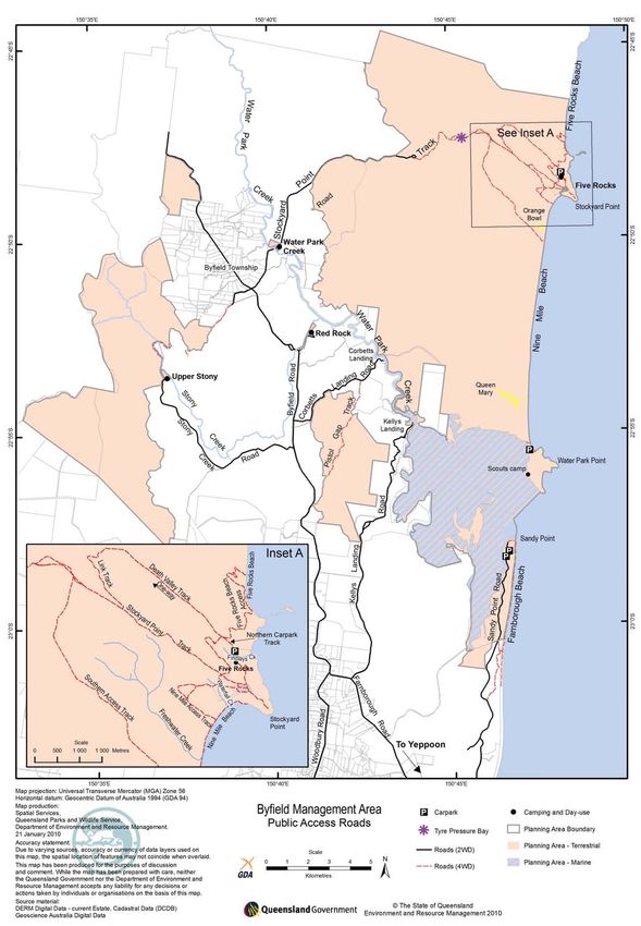
Central Queensland Coast Bioregion

Prepared by:
Planning Services Unit
Department of Environment and Resource Management

© State of Queensland (Department of Environment and Resource Management) 2010.

Copyright protects this publication. Except for purposes permitted by the Copyright Act 1968, reproduction
by whatever means is prohibited without the prior written permission of the Department of Environment
and Resource Management. Enquiries should be addressed to:

Department of Environment and Resource Management
GPO Box 2454, Brisbane Qld 4001.

Disclaimer
This document has been prepared with all due diligence and care, based on the best available information
at the time of publication. The department holds no responsibility for any errors or omissions within this
document. Any decisions made by other parties based on this document are solely the responsibility of
those parties. Information contained in this document is from a number of sources and, as such, does not
necessarily represent government or departmental policy.

This management plan has been prepared in accordance with the Nature Conservation Act 1992, Marine
Parks Act 2004, Forestry Act 1959 and the Land Act 1994.

This management plan does not intend to affect, diminish or extinguish Native Title or associated rights.

Note that implementing some management strategies might need to be phased in according to resource
availability.

For information on protected area management plans, visit www.derm.qld.gov.au.

Front cover photographs: Corio Bay, Photo:DERM
Byfield fern Bowenia serrulata, Five Rocks and Water Park Creek, Photos: Matt Kayes

May 2010

ISSN 1037-4698

Recycled paper saves energy and resources.

#29123

MP003

    ii       Byfield Area – management plan 2010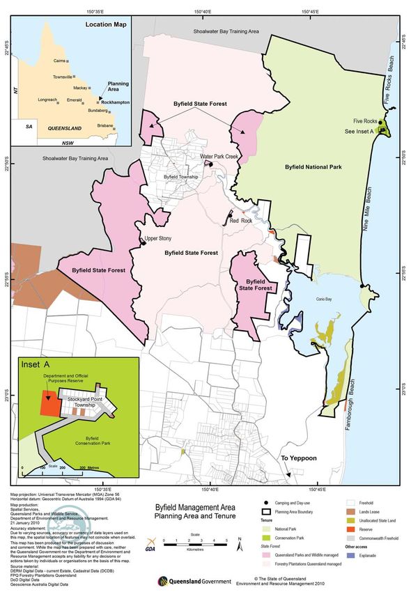
Vision
Future visitors to the Byfield Area will be presented, as they are today, with spectacular scenery of tall forests,
picturesque mountain ranges, clean flowing creeks and waterways, coastal dunes covered in an array of coastal
vegetation, with colourful wildflowers in spring.

The values of the Central Queensland Coast Bioregion are conserved, and plant communities and animal species of
conservation significance will be protected.

The community appreciates that the area protects the Byfield fern Bowenia serrulata and Byfield grevillea Grevillea
venusta along with extensive and diverse coastal heath communities, and species of flora and fauna threatened
nationally or in the State. Volunteers, neighbours and visitors actively cooperate and participate in controlling
threats such as pest plants and animals, and ensuring recreation activities have minimal impact on the area’s
natural and cultural values.

The Yeppoon – Rockhampton community appreciates and respects Byfield as an important area for Indigenous
people, and supports the reflection of Traditional Owners’ knowledge, interests, rights in and aspirations for the
area in all aspects of planning and management.

The community enjoys the aesthetic and environmental values of the area and demonstrates this in the respect they
show to the area and to other visitors.

Visitors to the management area enjoy nature-based recreation opportunities in a range of settings, from picnicking
in well-developed day-use areas to remote beach camping. Visitors enjoy these activities without impacting on the
area’s natural and cultural values.

Queensland Parks and Wildlife Service (QPWS) works in partnership with Traditional Owners, community groups,
businesses, local government and government agencies, and involves them in resolving the area’s management
issues in ways that foster pride, commitment and a sense of custodianship that supports the continuing
preservation of the area’s values for future generations.

             View from Mount Ganter, Byfield State Forest
             Photo: Matt Kayes, QPWS

                                                            Byfield Area – management plan 2010                  iii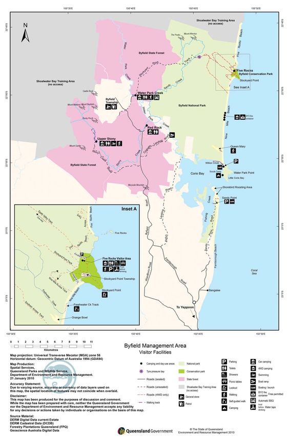
Contents
1.0 Management intent . . . . . . . . . . . . . . . . . . . . . . . . . . . . . . . . . . . . . . . . . . . . . . . . . . . . . . . . . . . . . . . . . . . . . . . . . . 1

2.0 Basis for management . . . . . . . . . . . . . . . . . . . . . . . . . . . . . . . . . . . . . . . . . . . . . . . . . . . . . . . . . . . . . . . . . . . . . . . 1

3.0 Location and regional context . . . . . . . . . . . . . . . . . . . . . . . . . . . . . . . . . . . . . . . . . . . . . . . . . . . . . . . . . . . . . . . . . . 2

4.0 Protecting and presenting the park values . . . . . . . . . . . . . . . . . . . . . . . . . . . . . . . . . . . . . . . . . . . . . . . . . . . . . . . 3

      4.1 Landscape . . . . . . . . . . . . . . . . . . . . . . . . . . . . . . . . . . . . . . . . . . . . . . . . . . . . . . . . . . . . . . . . . . . . . . . . . . . . . . 3

      4.2 Native plants and animals . . . . . . . . . . . . . . . . . . . . . . . . . . . . . . . . . . . . . . . . . . . . . . . . . . . . . . . . . . . . . . . . . 9

      4.3 Indigenous culture . . . . . . . . . . . . . . . . . . . . . . . . . . . . . . . . . . . . . . . . . . . . . . . . . . . . . . . . . . . . . . . . . . . . . . 12

      4.4 Shared-history culture . . . . . . . . . . . . . . . . . . . . . . . . . . . . . . . . . . . . . . . . . . . . . . . . . . . . . . . . . . . . . . . . . . . 13

      4.5 Visitor opportunities . . . . . . . . . . . . . . . . . . . . . . . . . . . . . . . . . . . . . . . . . . . . . . . . . . . . . . . . . . . . . . . . . . . . . 14

      4.6 Education and science . . . . . . . . . . . . . . . . . . . . . . . . . . . . . . . . . . . . . . . . . . . . . . . . . . . . . . . . . . . . . . . . . . . 32

      4.7 Partnerships . . . . . . . . . . . . . . . . . . . . . . . . . . . . . . . . . . . . . . . . . . . . . . . . . . . . . . . . . . . . . . . . . . . . . . . . . . . 33

5.0 Other key issues and responses . . . . . . . . . . . . . . . . . . . . . . . . . . . . . . . . . . . . . . . . . . . . . . . . . . . . . . . . . . . . . . . 35

      5.1 Pest plants and animals . . . . . . . . . . . . . . . . . . . . . . . . . . . . . . . . . . . . . . . . . . . . . . . . . . . . . . . . . . . . . . . . . . 35

      5.2 Fire management . . . . . . . . . . . . . . . . . . . . . . . . . . . . . . . . . . . . . . . . . . . . . . . . . . . . . . . . . . . . . . . . . . . . . . . . 36

      5.3 Climate change . . . . . . . . . . . . . . . . . . . . . . . . . . . . . . . . . . . . . . . . . . . . . . . . . . . . . . . . . . . . . . . . . . . . . . . . . 37

      5.4 Commercial resource activities . . . . . . . . . . . . . . . . . . . . . . . . . . . . . . . . . . . . . . . . . . . . . . . . . . . . . . . . . . . . 38

6.0 References . . . . . . . . . . . . . . . . . . . . . . . . . . . . . . . . . . . . . . . . . . . . . . . . . . . . . . . . . . . . . . . . . . . . . . . . . . . . . . . . 39

7.0 Hyperlinks . . . . . . . . . . . . . . . . . . . . . . . . . . . . . . . . . . . . . . . . . . . . . . . . . . . . . . . . . . . . . . . . . . . . . . . . . . . . . . . . 40

8.0 Appendixes . . . . . . . . . . . . . . . . . . . . . . . . . . . . . . . . . . . . . . . . . . . . . . . . . . . . . . . . . . . . . . . . . . . . . . . . . . . . . . . 41

Appendix A – Maps . . . . . . . . . . . . . . . . . . . . . . . . . . . . . . . . . . . . . . . . . . . . . . . . . . . . . . . . . . . . . . . . . . . . . . . . . . . . 41

Appendix B – Definitions and Acronyms . . . . . . . . . . . . . . . . . . . . . . . . . . . . . . . . . . . . . . . . . . . . . . . . . . . . . . . . . . . 51

Appendix C – Zones and Special Management Areas . . . . . . . . . . . . . . . . . . . . . . . . . . . . . . . . . . . . . . . . . . . . . . . . . 53

Appendix D - Tables . . . . . . . . . . . . . . . . . . . . . . . . . . . . . . . . . . . . . . . . . . . . . . . . . . . . . . . . . . . . . . . . . . . . . . . . . . . . 57

 Coastal Range view from Queen Mary Sandblow, Byfield National Park, Photo: Matt Kayes, QPWS

      iv          Byfield Area – management plan 2010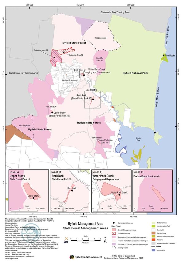
1.0 Management intent 2.0 Basis for management
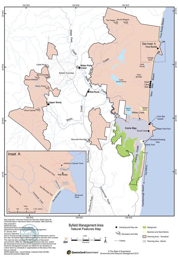
The Byfield Area management plan includes Byfield QPWS is responsible for the day-to-day management
National Park, Byfield Conservation Park, Byfield State of Byfield National Park and conservation park in
Forest managed by QPWS, the Departmental and accordance with the Nature Conservation Act 1992 and
Official Purposes Reserve at Stockyard Point, Corio Regulations. Byfield National Park covers 14,650ha
Bay and beaches of the State marine park, adjacent of the management area. Section 17 of the Nature
to these areas (Appendix A, Map 1). A multi-tenured Conservation Act specifies the management principles
planning approach provides an opportunity to plan for national parks. Byfield Conservation Park covers
and implement recreation, commercial and nature an area of 90ha adjacent to the township of Stockyard
conservation activities across the broader Byfield Point. Section 20 of the Nature Conservation Act
landscape. specifies the management principles for conservation
parks. The precautionary principle will apply to all
The primary purpose of management will be to:
aspects of the area’s management.
• conserve the diversity and distribution of native
plants and animals, particularly those species of QPWS is also responsible for the day-to-day on-ground
conservation significance management of designated recreation areas in Byfield
State Forest in accordance with the Forestry Act 1959.
• recognise the implications or likely impact of climate
QPWS manages approximately 8608ha of the State
change on the area, and manage the ecosystems to
forest area. Forestry Plantations Queensland manages
maximise resilience, and in so doing, contribute to
the remaining 15,460ha of State plantation forest.
biodiversity conservation
Areas managed by Forestry Plantations Queensland
• manage, where possible, pest plants and animals, are excluded from the management area. There are
with control methods having no, or minimal, adverse currently five specialised management areas declared
impacts on the natural values of the area under the Forestry Act in Byfield State Forest (Appendix
• reflect Traditional Owners’ knowledge and interests A, Map 2). Red Rock and Upper Stony camping and
in the area’s planning and management day-use areas are declared State forest parks in
• identify and protect Indigenous and shared-history recognition of their recreation values. There are also
cultural heritage places two scientific areas which were originally declared to
• monitor visitor activities, needs and expectations protect representative areas of native vegetation of
to provide relevant information for planning and high conservation significance to use as control sites
managing visitor use when monitoring environmental health through the
State forest. The fifth special management area is a
• provide a diversity of safe, sustainable, nature-
feature protection area which was declared to protect a
based recreation opportunities
gully that has significant scenic values.
• encourage appropriate visitor activities in a manner
that minimises impacts on the values and other This plan applies to Byfield National Park, conservation
visitors park, State forest managed by QPWS and adjoining
tidal lands in the Great Barrier Reef Coast Marine Park
• provide a framework to appropriately balance public
(Queensland). The national park extends down to mean
and commercial access opportunities
high water springs, and tidal lands between the mean
• manage potential conflict between different users high water springs and mean low water springs are
and activities part of the surrounding Great Barrier Reef Coast Marine
• encourage cooperative and collaborative Park (Queensland). Tidal lands include beaches, sand
partnerships between stakeholders for management spits and rocky foreshores. The Great Barrier Reef
purposes Coast Marine Park (Queensland) is managed under
• provide for, and encourage, bonafide scientific the authority and provisions of the Marine Parks Act
research, surveys and monitoring. 2004 and regulations. Section 11 of the Marine Parks
Regulation 2006 provides for management plans to
Little Five Rocks Beach and headland, Photo: Matt Kayes, QPWS
Byfield Area – management plan 2010 1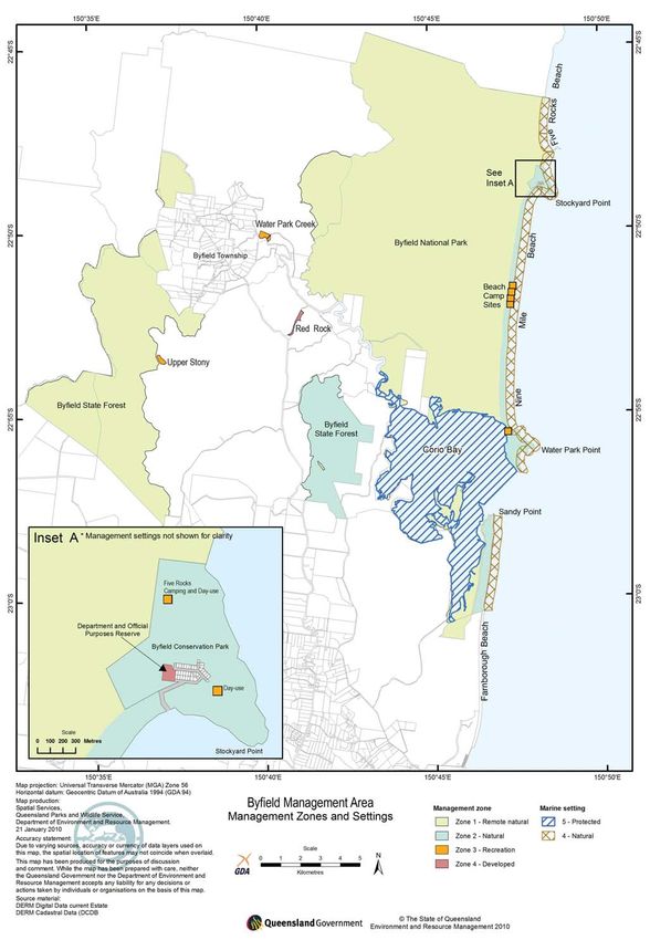
apply to tidal lands adjoining national parks. Inclusion   Sandy Point, part of Byfield National Park can also be
of the tidal lands in this plan will help QPWS manage      accessed from a private road owned by Iwasaki Sangyo
the national park and adjoining tidal areas in a           Corporation (Rydges Resort) (Appendix A, Map 6).
consistent manner.                                         Access is provided to QPWS through the provisions set
                                                           out under section 15 of the Queensland International
Corio Bay is in the Shoalwater Bay and Corio Bay
                                                           Tourist Centre Agreement Act Repeal Act 1989. This
(Queensland) Ramsar area – an area recognised as a
                                                           provision does not provide for public access; however,
wetland of international significance.
                                                           Iwasaki Sangyo has allowed the access to be used by
Corio Bay and the beaches in the management area           the public.
lie in the Great Barrier Reef Coast Marine Park (State
                                                           Legal vehicle access to Stockyard Point is via the sea,
marine park). There is also a small section of beach at
                                                           although most land holders access their properties on
the southern end of Five Rocks Beach which lies in the
                                                           the national park road. The Departmental and Official
habitat protection zone (Appendix A, Map 3).
                                                           Purposes Reserve at Stockyard Point is the only land
The provisions of the Environment Protection and           parcel in the township considered in this management
Biodiversity Conservation Act 1999 (Commonwealth),         plan.
Ramsar and subordinate regulations apply to the
                                                           A Native Title claim has been lodged over the area
national parks because of their World Heritage listing
                                                           on behalf of the Darumbal people. This plan is not
and presence of migratory species listed under the
                                                           intended to impinge on any native title rights or
Bonn Convention, the China-Australia Migratory Bird
                                                           interests. The plan will facilitate the involvement of
Agreement, Japan-Australia Migratory Bird Agreement
                                                           the Traditional Owners in the management of the area.
and Republic of Korea-Australia Migratory Bird
                                                           Indigenous cultural heritage places are a custodial
Agreement.
                                                           responsibility of Traditional Owners. Cultural heritage
Endangered and of concern regional ecosystems are          places in the management area are legislatively
described under the Vegetation Management Act              managed under the Queensland Heritage Act 1992
1999 and endangered, vulnerable and rare species           and the Aboriginal Cultural Heritage Act 2003. Cultural
are listed under the Nature Conservation (Wildlife)        resource management is in accordance with the Charter
Regulation 2006. QPWS is responsible under the Land        for the Protection and Management of Archaeological
Protection (Pest and Stock Route Management) Act           Heritage and the Burra Charter, which provides detailed
2002 for controlling declared pest plants and animals      guidelines for the management of cultural heritage
on protected areas.                                        places.

The management plan provides directions to manage          The State Coastal Management Plan describes how the
a Departmental and Official Purposes Reserve at            surrounding waters will be managed in the statutory
Stockyard Point; this reserve is gazetted under the        planning and development assessment framework
Land Act. The small reserve covering about 1.2ha (Lot 1    of the Coastal Protection and Management Act
on CP863044; Appendix A, Map 1) at Stockyard Point is      1995. It defines the national park and conservation
managed by QPWS through a trustee agreement under          park as areas of State significance for both their
the Land Act. This allows QPWS to manage the area          natural resources and scenic coastal landscapes. It
consistently with management of the nearby national        identifies the waters for low-key, nature-based visitor
park, conservation park and State forest.                  opportunities.

A Fish Habitat Area has also been declared over the
waters and wetlands of Corio Bay (Appendix A, Map 3).
Fish Habitat Areas are administered under the Fisheries
                                                           3.0 Location and regional
Act 1994 by the Department of Employment, Economic         context
Development and Innovation to protect fish habitats
(such as the wetlands, sand bars and waters) from          The management area covers about 22,000ha and
direct physical disturbance and development, helping       is located 30km north of Yeppoon and 84km north
to maintain local and regional fisheries.                  east of Rockhampton. It is bordered to the north
                                                           and north-west by the Shoalwater Bay Training Area,
The Rockhampton Regional Council currently regulates       a large natural area owned and managed by the
the use of vehicles on all beaches in the management       Commonwealth Government. Freehold land owned by
area under the Rockhampton Regional Council                Forestry Plantations Queensland and Iwasaki Sangyo
Subordinate Local Law 17 (Parks and Reserves) 2007.        lies to the south. Forestry Plantations Queensland
Under this local law, four-wheel drive vehicles are        manages native forest and plantations of native
permitted to drive on Farnborough Beach and Nine Mile      and exotic pine trees on State forests designated as
Beach, and motorbikes and quad bikes are permitted         State plantation forest (Appendix A, Map 1). Most of
to drive on Nine Mile Beach. Vehicle use is not            the northern part of Rydges Resort land remains in
permitted on other beaches in the management area.         a natural, undeveloped state. The combination of

    2       Byfield Area – management plan 2010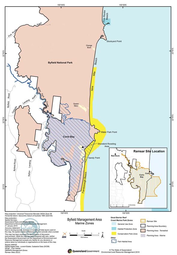
the management area and adjacent land makes the              blows, Orange Bowl and Queen Mary (Appendix A, Map
broader Byfield area one of the largest undeveloped          4), provide breaks in the vegetation and contribute to
sections of Australia’s east coast.                          the diversity in the natural landscape setting. Further
                                                             inland, lowland swamps, rainforest-edged creeks, pine
There are two townships, Byfield and Stockyard Point,
                                                             plantations and rugged mountains complement the
associated with the management area (Appendix A,
                                                             diverse coastal landscape.
Map 1). Byfield has a population of about 250 people
and supports cottage industries, ecotourism style
accommodation ventures and basic corner store
facilities. It provides a welcome and increasingly
important attraction for tourists to the Capricorn
Coast region. Stockyard Point is a smaller township
surrounded by the Byfield Conservation Park.

From the Byfield Area, visitors can explore other natural
places in the Capricorn Coast and Capricorn region,
including:
• Capricorn Coast National Park, Keppel Sands
  Conservation Park, Flat Top Range Resources
  Reserve and Mackenzie Island Conservation Park to
  the south
• Keppel Bay Islands National Park, adjoining Great
  Barrier Reef Coast Marine Park and Great Barrier Reef
  Marine Park to the east
• the natural wonders of a volcanic plug at Mount
  Jim Crow National Park, located on Yeppoon -
  Rockhampton Road                                           Swamp Banksia Country, Byfield National Park,
• the unique underground cave system at Mount Etna           Photo: Matt Kayes, QPWS
  Caves National Park to the west.
                                                             Mount Atherton rises to 438m (Appendix A, Map
                                                             4) above sea level and contains part of the water
4.0 Protecting and presenting                                catchments for Sandy and Stony creeks. Stony Creek
                                                             finishes in Water Park Creek.
the park values
                                                             Corio Bay is a shallow bay with a tidal range of
This section outlines the special natural and cultural       approximately two to three metres, which exposes
values of the management area, and policies, actions         large sections of coastal shoreline at low tide. This is a
and guidelines to protect and present these values.          very dynamic section of coastline where large amounts
                                                             of sand can be moved in a few tides. These natural
                                                             processes provide an ever-changing and spectacular
4.1 Landscape                                                scenic amenity.

4.1.1 Scenic amenity                                         The scenic landscapes of the sand and waters in the
                                                             bay are not found elsewhere along the Capricorn Coast.
The management area is located in a diverse,                 An increasing number of unpermitted structures are
undeveloped region on the Queensland coast.                  mooring in Corio Bay for long periods of time and are
The foreshore consists of long, sandy beaches                detracting from the scenic amenity values of the bay.
intersected with rocky headlands and the Five Rocks          There are currently two designated areas for boats to
outcrop. Infrastructure and residential development          launch into Corio Bay. One is located at Sandy Point
is well hidden from the foreshore, creating a natural        into Fishing Creek and the other off the northern beach
scenic landscape that can be viewed from the water,          of Corio Bay (Appendix A, Map 9). These boat launch
headlands and foreshore. This natural coastal                locations are natural. Building semi-permanent or
landscape is becoming rare along the Queensland              permanent built structures for boat launching is likely
coast due to continued urban development in non-             to impact on the vista of Corio Bay.
protected areas.
                                                             The scenic amenity values of the management area
Behind the foreshore, massive sand dunes (known as           are an important part of the attraction for visitors to
parabolic dunes) are cloaked with heath, woodland            the area and therefore are of social and economic
and forest-dominated landscapes. Two significant sand        importance to the local community.

                                                            Byfield Area – management plan 2010                   3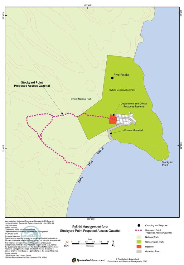
Table 1 Management strategy for scenic amenity

 Desired outcome 2020            Actions and guidelines

 The management area is          A1.   Ensure infrastructure (other than roads, walking tracks and information) is contained
 retained as a relatively              to the existing visitor areas in the management area.
 undeveloped coastal             A2.   Ensure new or upgraded recreation and management facilities blend with the natural
 landscape.                            landscape as far as possible, particularly in respect to design and colour scheme.
 Infrastructure supporting       A3.   Infrastructure that will be seen from the sea or coastal lookouts will generally not be
 recreation and management             supported unless essential for visitor safety or area’s management. In such cases,
 are not adversely impacting           landscape impacts should be mitigated to the greatest possible extent.
 on landscape values.
                                 A4.   No private mooring to be permitted in Corio Bay.
 No vessels or structures
 are permanently moored or       A5.   Waters in Corio Bay to have no permanent structures or facilities.
 permanently anchored in         A6.   Ensure vessels anchor in Corio Bay in accordance with the State zoning plan.
 Corio Bay.
                                 A7.   Rationalise and maintain the track system in the management area as outlined in
 The vehicle track network             Appendix A, Map 6.
 does not impact on the scenic
                                 A8.   Avoid developing tracks and roads where they can be viewed from the sea or coastal
 amenity values.
                                       lookout points, or where they provide a significant scar on the landscape (for
                                       example, directly up hill slopes and dunes).
                                 A9.   Investigate opportunities for developing voluntary conservation agreements (such as
                                       nature refuge agreements) with adjoining land owners.

Lower Swamps, Byfield National Park, Photo: Matt Kayes, QPWS

    4       Byfield Area – management plan 2010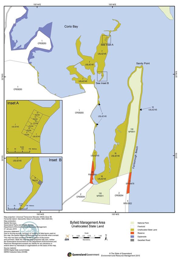
4.1.2 Marine and coastal environments
The coastline in the management area is a highly            Disturbed soil can lead to sedimentation of the water
dynamic system. Natural forces shape the coastline          courses that flow out into the marine park.
through a combination of erosion and accretion. For
                                                            Likewise, any pollution, both nutrient and physical,
example, the entrance to Corio Bay was once located
                                                            is likely to flow through the catchment and end up
just to the north of Bangalee, about 12km south of its
                                                            in the marine environment. Rubbish left by visitors
current location. The combination of onshore sediment
                                                            can impact on marine animals – entanglement of
transport and slight northward longshore transport in
                                                            turtles, fish and dugong in fishing line, and ingestion
the Bangalee area, and some southward longshore
                                                            of floating debris such as plastic bags and cigarette
transport along Nine Mile Beach, gradually moved
                                                            butts causing choking are examples of potential
the entrance to Corio Bay to the north and caused the
                                                            impacts. Toilet waste or chemicals used for pest plant
formation of the spit at Sandy Point.
                                                            control can also have adverse impacts on the quality of
Over the past 90 years, there has been a continuation       marine park waters by contributing to algal blooms or
of the northern growth to the Sandy Point spit. In 2006,    damaging seagrass and reefs. Direct disposal of waste
a combination of events removed 500m of vegetated           into marine park waters is not permitted. It is important
dune and drastically changed the area for recreation        that land-based management and recreation activities
use and shorebird roosting and nesting. Although            do not cause impacts on the end point of catchment
the area is always dynamic, this was a massive event        processes – the marine environment.
for Corio Bay, and will have impacts on the area
well into the future. These changes have become a
problem for launching boats, as the site has soft sands
with steep slopes, which have resulted in vehicles
becoming bogged and submerged. The dynamics and
unknown future movements will require an adaptive
management approach to protect infrastructure and
ensure that conflict between recreation users and
shorebirds is minimised.

Nine Mile Beach and the northern section of
Farnborough Beach have a historical trend of dune
erosion. This is due largely to the exposed nature
of these beaches compared with the more southern
beaches where the Keppel Bay islands provide some
protection from wind and wave action. Past cyclones
and storm surges have also contributed to significant
erosion events. However, between 1975 and 1996, the
trend has been towards accretion on the beaches in
the management area. These natural coastal processes
only become a problem when development and
infrastructure is threatened, or when access to areas
is compromised. Infrastructure should be excluded
from areas likely to be impacted or altered by natural
processes. Impacts from natural processes are likely to
be exacerbated by climate change.

Coastal waters are a major attraction for many
visitors. The beaches, sea and waters of Corio Bay
add significantly to the scenic amenity of the Byfield
area, and are valued recreation areas. Activities in the
broader management area have the potential to impact
on the amenity and quality of marine park waters.           Stockyard Lookout, Photo: Matt Kayes, QPWS

                                                           Byfield Area – management plan 2010                 5
Table 2 Management strategy for marine and coastal environments

 Desired outcome 2020              Actions and guidelines

 Natural coastal processes         A10. Ensure infrastructure is located as far landward as practical.
 occur with minimal human          A11.   For essential development on the foredunes threatened by natural coastal processes
 intervention.                            (such as tracks and bollards), adopt a strategy of retreat rather than protecting the
 Park operations, commercial              development.
 and recreation activities are     A12.   Permanent beach protection structures should not be used. If temporary structures
 not adversely impacting on               are to be installed, biodegradable products are to be used.
 the health and amenity of the
 marine environment.               A13.   Allow natural sand movement processes to continue to operate in Corio Bay without
                                          interference (including no dredging of channels or construction of beach protection
                                          structures).
                                   A14.   Vehicles, camping, built structures and fires will be discouraged from erosion-prone
                                          areas to prevent erosion and enhance the natural values of the area.
                                   A15.   Rehabilitation of the foredunes will be assessed with regard to long-term natural
                                          cycles, hydrology, landform and biology of vegetation and nesting species.
                                   A16. Monitor beach access points, coastal tracks and foredunes for signs of degradation
                                        from visitor and management use.
                                   A17.   Prohibit toilet waste disposal from vessels in Corio Bay.
                                   A18. Maintain the long-standing policy of not providing rubbish bins.
                                   A19.   Ensure visitors are aware of the need to take all rubbish out of the management area.
                                   A20. Encourage appropriate disposal of toilet waste by campers.
                                   A21.   If coastlines are being impacted by visitors or management, an assessment of the
                                          impacts will be completed and appropriate action taken.

4.1.3 Land tenure
There are many land parcels in, and associated with,               QPWS-managed State forests will be assessed by the
the management area.                                               Queensland Government. Any future tenure changes
                                                                   will need to recognise and consider these permitted
There are a number of parcels of unallocated State
                                                                   uses.
land on the southern side of Corio Bay (Appendix A,
Map 5) that have not yet been assigned tenure. DERM                Byfield State Forest also contains five specialised
is responsible for allocating tenure to State land based           management areas declared under the Forestry Act.
on the most appropriate use of the land to support the             Two of these are scientific areas (Appendix A, Map
economic, social and physical wellbeing of the people              2) declared to provide representative areas of native
of Queensland. Some of the unallocated State land is               vegetation in the harvested area of State forest. These
completely surrounded by national, conservation and                areas contain vegetation of conservation significance,
marine park. It is desirable for these land parcels to             including endangered regional ecosystems. National
be incorporated into the national park in recognition              park tenure is considered a more appropriate tenure
of their significant natural wetland values and to                 to reflect the biodiversity values of these areas.
rationalise boundaries in the management area.                     Converting Scientific Area 31 to national park will also
                                                                   help rationalise tenure in the management area.
The State forest in the management area is currently
used and managed for a range of activities. Some areas             Another specialised management area has been
are managed with a strong emphasis on the protection               declared as a feature protection area (Appendix A, Map
of the natural and cultural values.                                2) to protect a scenic gully of piccabeen palms and
                                                                   other rainforest plants. The values of this area can be
Converting these areas to national park, particularly
                                                                   adequately protected without the special management
areas directly adjacent to existing national park, would
                                                                   area declaration.
more accurately reflect current and proposed land uses
and management.                                                    The remaining two specialised management areas are
                                                                   State forest parks associated with recreation use at
Other areas of State forest are used for commercial
                                                                   Red Rock and Upper Stony camping and day-use areas
purposes. There is one grazing lease of 954ha over
                                                                   (Appendix A, Map 2). These areas currently lie in State
State forest, and a second grazing lease in the
                                                                   plantation forest managed by Forestry Plantations
adjacent State plantation forest (Appendix A, Map
                                                                   Queensland, although QPWS has agreed to manage
2). In the longer term, it is likely that the tenure of all
                                                                   these areas. QPWS also manages the recreation

    6        Byfield Area – management plan 2010
facilities at Water Park Creek, which is not declared as
a specialised management area. It is desirable to have
a consistent management basis for all three camping
and day-use areas located on State forest.
The adjoining beaches (Appendix A, Map 1) are in the
Great Barrier Reef Coast Marine Park (Queensland).
Beach activities are regulated under the Marine
Parks Act and the Rockhampton Regional Council
Subordinate Local Law 17 (Parks and Reserves) 2007.
The Departmental and Official Purposes Reserve at
Stockyard Point is currently managed by QPWS as
trustee under the Land Act. This reserve has been
managed with an emphasis on environment protection.
Stockyard Point township requires land for water
extraction and future community infrastructure. It
is desirable for the reserve to be managed to meet
the needs of the broader community, subject to Waterpark Creek, Byfield State Forest,
conditioning of environmental and amenity issues. Photo: Matt Kayes, QPWS
Table 3 Management strategy for land tenure
Desired outcome 2020 Actions and guidelines
Land with high natural, A22. Investigate the suitability of the following parcels of unallocated State land adjacent
cultural and/or landscape to Corio Bay for inclusion into Byfield National Park:
values are gazetted as • Lot 16 USL42145
national or conservation park
and incorporated into the • the area of Lot 7 USL42145 to the north of freehold Lot 1 CP839293
management area. • Lots 9 to 14 PS104
Land tenures in the • Lot 8 PS103 (Appendix A, Map 5).
management area are
A23. Transfer Scientific Area 31, the western section of Scientific Area 32 (Appendix A,
consistent with use and
Map 2) into the Byfield National Park.
management intent.
A24. Remove declaration of State Forest Parks 10 and 13, and Feature Protection Area 48
(Appendix A, Map 2) and continue to manage the values of these areas under the
Forestry Act.
A25. If freehold or leased land directly adjacent to the management area becomes
available, consider acquiring such land for inclusion into protected area tenure.
A26. Proceed with State plantation forest boundary changes to exclude Water Park Creek;
Red Rock and Upper Stony recreation areas from Forestry Plantations Queensland
managed State forest.
A27. Continue to work with Forestry Plantations Queensland as outlined in the
Memorandum of Understanding.
A28. Ensure any estate additions to the management area reflect that this management
plan is to apply.
A29. QPWS to relinquish the trusteeship on the Departmental and Official Purposes
Reserve to Rockhampton Regional Council to enable the reserve to be managed
for broader community uses, subject to native title requirements being met and
conditioning of environmental and amenity issues.
Byfield Area – management plan 2010 74.1.4 Freshwater systems
The forested upper slopes of the catchments provide over the aquifer system’s vulnerability to saltwater
a high level of protection, resulting in good quality intrusion. Overuse of the groundwater resources in
surface water. the management area, particularly in areas close to
the coastline, could affect the supplies of other users
The parabolic dune systems acts as a long-term water
and cause salt water intrusion into the aquifer. The
storage and filter system, with rainfall taking up to
water quality at locations sufficiently removed from the
100 years to reach the waterways in the management
influence of the adjacent coastline is generally suitable
area. The resulting high-quality water and the relatively
for most purposes. All bores in declared sub-artesian
undisturbed stream environments are important
districts, other than for private domestic or stock
refuges for native aquatic flora and fauna species and
purposes, require a licence from DERM.
communities.
QPWS operates a licensed bore in the Byfield
The Rockhampton Regional Council currently provides
Conservation Park near the Five Rocks camping area.
water to many Capricorn Coast residents from Water
The water extracted from this bore is used to supply
Park Creek. The catchments of these creeks largely lie
the shower and toilet facilities at the campground, and
in the management area. A pipeline from the Fitzroy
also to supply a water storage tank for fire management
River to the Capricorn Coast is being installed and will
purposes. There are no other bores in use, although
reduce the need for water to be harvested from Byfield
the Stockyard Point Services Cooperative has current
catchments in the future.
licences and permits to extract water from a spring
The walking track from the Byfield Conservation Park in the Byfield Conservation Park. This water source is
campground parallels Findlays Creek to the beach. subject to significant fluctuations dependent on rainfall
Upper Stony and Freshwater creeks are regularly and use, and has not been used since 2002 due to lack
used by swimmers. Managing recreation use in and of water.
around these creeks and protecting water quality will
The residents of Stockyard Point have sought a reliable
be important so that swimming in these systems can
town water supply. The Reserve for Departmental and
continue.
Official Purposes has been assessed by DERM and
Large areas of the management area lie in the there are no environmental or sustainability concerns
Farnborough groundwater management unit. This associated with extracting water for domestic purposes
unit was declared as a sub-artesian district under to supply the Stockyard Point township.
the provisions of the Water Act 2000 due to concern
Table 4 Management strategy for freshwater systems
Desired outcome 2020 Actions and guidelines
The catchments of the A30. Avoid works that may compromise local surface hydrology or water quality. Where
management area are works may impact on freshwater systems, ensure appropriate mitigation is used to
continuing to provide good protect water quality, particularly from sedimentation or contamination.
quality surface waters. A31. Promote and enforce all campsites to be at least 50m away from watercourses and
Park operations and lakes.
recreation activities have A32. Promote sustainable, low-impact recreation practices (particularly appropriate bush
minimal impact on the quality toileting and waste disposal).
of surface water.
A33. Conduct regular water testing to ensure quality meets standards for recreation
Visitors are enjoying swimming.
high quality recreation
opportunities without A34. Advise Rockhampton Regional Council of DERM’s requirements for managing water
impacting on the water quality extraction on the Departmental and Official Purposes Reserve including:
and amenity of the freshwater • Allow the bore to provide a supplementary source of domestic water to the
systems. town, with stored rainwater providing the largest percentage of water used per
Groundwater extraction household.
is sustainable in relation • Ensure the proposed facilities minimise impact on the visual amenity of the area.
to quality and quantity
and causes no adverse
environmental impacts.
8 Byfield Area – management plan 20104.2 Native plants and animals
The management area is located entirely in the Central
Queensland Coast Bioregion. The diverse geology and
landforms, combined with a comparatively high annual
rainfall has contributed to the diversity of vegetation
communities and habitats for native animals.
There have been a number of plant and animal surveys
undertaken since the early 1990s. Some of these
surveys were undertaken as part of environmental
impact assessments and enquiries associated
with proposed sand mining, and others have been
completed by QPWS to provide an inventory to guide
management actions. This section of the plan outlines
some of the significant biodiversity values of the
management area and provides guidance on the future
management of these values.
4.2.1 Native plants Byfield grevillea, Grevillea venusta, Photo: Matt Kayes, QPWS
Thirty-six regional ecosystems have been mapped
(Appendix D, Table 1), including two that are listed as
from State forest for the commercial cut-flower market
endangered and 20 that are listed as of concern under
and for propagation. There is very little of the endemic
the Vegetation Management Act. In these diverse
Byfield matchstick in the management area and little
ecosystems, more than 400 plant species have been
is known about its ecological requirements. There are
identified. One of the species is listed as endangered,
also a number of plant species near the limit of their
five are listed as vulnerable and two are listed as rare
distribution, including the most northern distributions
under the Nature Conservation (Wildlife) Regulation
of swamp mahogany Eucalyptus robusta and small-
2006 (Appendix D, Table 4).
leaved geebung Persoonia virgata.
Plant species of particular note are the Byfield fern
Mangroves, wetlands, rainforests and beaches are
Bowenia serrulata which is endemic to the Byfield
significant habitats for a diverse range of species in the
area, Commersonia perkinsiana and Byfield matchstick
management area (Ponniah 1993).
Comesperma oblongatum, an endemic vulnerable
shrub recorded at Stockyard Point headland. Other There are 13 species of mangroves found in and around
significant plant species are Sowerbaea subtillis, an Corio Bay (Beach Protection Authority 1979). Corio Bay
endemic vulnerable herb recorded at Water Park Creek, is included in the Directory of Important Wetlands in
Phaius australis, an endangered orchid recorded Australia. Corio Bay was registered as a Ramsar site
at Sandy Creek, and the Byfield grevillea Grevillea in 1995 in recognition of its internationally significant
venusta, a vulnerable species endemic to the Port wetland values.
Curtis Pastoral District.
The most significant threats to the regional ecosystems
The management area supports good populations of and plant species are invading pest plants,
some of these species. The Byfield fern (and a number inappropriate fire regimes, climate change and damage
of other common species) is collected under permit caused by visitor access and recreation use.
Orange Bowl sandblow, Photo: Matt Kayes, QPWS
Byfield Area – management plan 2010 9Table 5 Management strategy for native plants
Desired outcome 2020 Actions and guidelines
The quality and extent A35. Minimise, where possible, impacts on vegetation from pest plants and animals,
of current vegetation management actions and visitor activities.
communities and known A36. Encourage further detailed plant surveys in the higher altitude areas of the Byfield
populations of threatened Range and Mount Atherton.
species are maintained.
A37. Continue to enter plant location information, particularly plants of conservation
Information on the vegetation significance, into WildNet, the QPWS’s database of plants and animals.
communities and plant
species of the management A38. Map the distribution and relative abundance of Byfield fern to help sustainably
area continues to increase. manage commercial harvest from State forest areas.
The distribution and A39. Monitor known populations of Byfield matchstick and Commersonia perkinsiana and
abundance of endemic record responses to disturbances and ecological data such as flowering and fruiting
species such as Byfield fern times and germination events.
are known. Byfield matchstick A40. Exclude vehicles from Stockyard Point headland except for the turn around area,
exist in the management area. to protect the populations of Byfield matchstick Comersperma oblongatom and
Commersonia perkinsiana.
A41. Formalise a walking track around the Stockyard Point headland to reduce visitor
impacts on Byfield matchstick and Commersonia perkinsiana.
A42. Through interpretive material educate visitors of the endemic and vulnerable Byfield
matchstick and Commersonia perkinsiana at Stockyard Point headland.
A43. Minimise disturbances to vegetation communities by management and visitor
activities such as; encourage visitors to stay on designated tracks, and close and
rehabilitate tracks as required.
4.2.2 Native animals
The diverse vegetation communities and topography been sporadically counted over the years and a more
in the management area provide a broad range of specific effort is required to determine the long-term
habitats that support a diversity of native animals. health of the system for shorebirds.
More than 145 bird species have been recorded in the Corio Bay is a declared Fish Habitat Area (Appendix
area including 15 which are listed as rare, vulnerable or A, Map 3) in recognition of its importance as habitat
endangered under the Nature Conservation (Wildlife) for many native species of fish. Anecdotal sightings
Regulation 2006 (Appendix D, Table 2). Twenty of dugong and turtles have been made, but the small
migratory bird species are listed in the China-Australia amount of seagrass and large amount of area exposed
Migratory Bird Agreement and/or Japan-Australia at low tide means that it is not considered an important
Migratory Bird Agreement (Appendix D, Table 3). habitat for either animal.
Sandy Point and Corio Bay are significant wading bird
sites, with records of up to 15,000 birds roosting and
feeding between September and March each year.
Comparisons with other wetland areas in central
Queensland show that Corio Bay has the highest count
of red necked stints, red capped plovers, sanderlings
and double banded plovers. Sandy Point has been
recognised as an important nesting site for the
endangered little tern.
Corio Bay is considered one of the most significant
wetlands in the Central Queensland Coast Bioregion,
as it is one of only a few wetland areas that lie in
a relatively undeveloped catchment. Wetlands are
important feeding, roosting and breeding sites for a
number of species.
The Australian and Queensland Wader Study Groups
use migratory shorebirds as indicator species for Emu, Dromaius novaehollandiae,
wetland health. Shorebird numbers in Corio Bay have Photo: Matt Kayes, QPWS
10 Byfield Area – management plan 2010The rocky headland beaches near the entrance to Corio
Bay supports low numbers of flatback turtles, Natator
depressa during breeding season (Ponniah 1993).
Twenty-six species of reptile have been recorded from
the area, of which, the estuarine crocodile, Crocodylus
porosus is listed as vulnerable and the death adder,
Acanthophis antarcticus is listed as rare.
More than 70 mammals have been recorded. The
northern quoll, Dasyurus hallucatus, last recorded
in the area in 1997, is listed as endangered under
the Commonwealth Environment Protection
and Biodiversity Conservation Act. Brush-tailed
phascogales, Phascogale tapoatafa are known to
inhabit the areas around Red Rock camping area
and are often spotted at night foraging for food. The
Black-tailed monitor, Varanus tristis,
rocky ridges of the coastal ranges provide protection
Photo: John Augusteyn, QPWS
and homes for up to 25 bat species. The vulnerable
ghost bat Macroderma gigas has been recorded in the
Corio Bay and adjacent mangroves provide critical area. A false water-rat Xeromys myoides was sighted
habitat for a diverse range of aquatic organisms. in the Shoalwater Bay region and it is likely that this
The area is known to be important for fish, crabs vulnerable species also inhabits the mangrove habitats
and prawns, particularly banana prawn Penaeus of Corio Bay and Dismal Swamp.
merguinesis (Ponniah 1993).
Dingoes are known to occupy the lands in the
Beaches provide important habitat for invertebrates management area and have been reported to come
such as amphipods, isopods, molluscs, polychaeles close to camp sites. Feeding of dingoes is discouraged
and crustaceans and provide a feeding ground for fish to reduce reliance on humans for food and to ensure
and seabirds. that both visitors and dingoes remain safe.
Sea materials washed-up onto the beaches provide Threats to native animals include inadequate
food for birds and invertebrates. The rocky headlands foraging, breeding and roosting sites, competition for
and islands in Corio Bay support organisms such as resources from introduced animals, disturbance to
algae that can tolerate fluctuations in water levels from soil and vegetation, human recreation activities and
tidal movement (Campbell 1989). They also provide inappropriate fire regimes and practices.
roosting areas for shorebirds.
Fauna conservation cannot be considered in isolation
Threats to marine species can be from litter (digestion from adjacent areas. Wildlife corridors linking the
and entanglement), bait collection, pollution (oil spills) area to other government-managed lands and private
and trampling (Ponniah 1993). Impacts from trampling property are important. Fragmentation of forest
on these values are to be managed. blocks in the broader landscape by roads, plantations
and cleared private property may also restrict the
Marine species characteristics of open waters of the
movements of fauna between local populations,
management area include those that are pelagic
increasing the risk of their local decline or extinction.
(actively swimming) and planktonic (drifting in current).
Planktonic species rely on currents for movement,
nutrients and food. Some inter-tidal organisms spend
early stages of their life in this environment (Parks
Victoria 2006). Pelagic fish may migrate in the coastal
waters and Corio Bay. Over 1400ha of suitable habitat
has been mapped in Corio Bay (J McCabe, pers. com.).
Whales are known to traverse the waters during
migration and can be seen from the headlands in the
management area. Other marine mammals in the area
include dugong, dolphins and turtles.
Rainforests including vine scrubs in the management
area are critical for the fruit pigeons, and other birds,
as permanent habitat and providing protection for Baby Water Dragon, Stony Creek, Byfield State Forest,
migratory species. Photo: Matt Kayes, QPWS
Byfield Area – management plan 2010 11Table 6 Management strategy for native animals
Desired outcome 2020 Actions and guidelines
Detailed information about A44. Encourage visitors to report interesting sightings and continue to enter animal
the habitat and distribution of location information into WildNet.
animals are available to guide A45. Support the Queensland Wader Study Group and other groups to survey shorebirds
management decisions. and incorporate findings of bird surveys at Corio Bay into the Coastal Bird Atlas.
Species of conservation A46. Monitor the distribution, abundance and habitat condition of rare, threatened and
concern remain at viable other animal species of conservation significance. Results from monitoring will be
population levels. analysed and used to inform management decisions.
Fire, pest plants and animals, A47. Monitor known populations of the death adder and record responses to disturbances
and visitor management and ecological data such as breeding and natural migration patterns.
practices are conducive to
protect the area’s native A48. Ensure that management practices and visitor use have minimal impact on rare,
animals. threatened and other animal species of conservation significance.
Knowledge on the marine A49. Inform visitors of the marine values and visitor impacts such as littering and
ecological communities aid trampling through interpretive materials.
management, protection and A50. Maintain the abundance and diversity of native animals through active habitat
potential impacts. management including pest control and fire management.
Fires are being managed
to meet the ecological
requirements of fire-
dependant fauna species.
4.3 Indigenous culture
The Darumbal people are the registered Native Title Protection of Aboriginal cultural heritage places is
claimants for the management area. Their traditional important for the Darumbal people to understand and
use of the management area is part of a much larger connect with past history. Likewise, there are many
cultural system, with various clans spanning a land landforms and features important to the Darumbal
area from north of Curtis Island to St Lawrence and people because of their spiritual significance. The
west past Gracemere. Darumbal people have a complex Darumbal people have a strong sense of ownership
and diverse social and spiritual culture. of information about the Indigenous cultural values
of the area. This plan respects this ownership. At
The Darumbal people have reclaimed their interest
the same time, the Darumbal people are willing to
in the management area, which is not limited to
share and teach visitors about their history through
protecting and managing archaeological sites.
interpretation.
Various archaeological surveys were completed in the
Indigenous cultural heritage may require active
1980s and ‘90s. These surveys located a series of shell
management to ensure their protection from erosion,
middens along the management area’s frontal dune
recreation activities and removal. It is important for
systems and headlands. Stone tool artefacts were
QPWS to work with Traditional Owners to ensure
also found. It is likely that further sites are yet to be
appropriate measures are taken to protect known
discovered.
areas.
Heathland, Photo: John Augusteyn, QPWS
12 Byfield Area – management plan 2010Table 7 Management strategy for Indigenous culture
Desired outcome 2020 Actions and guidelines
Indigenous cultural heritage A51. Continue to encourage Traditional Owner involvement in the area’s planning and
places are protected from management.
visitor and management A52. Continue to build strong relationships with the Darumbal people to ensure that
activities. communication gaps don’t adversely impact on protecting cultural heritage values.
The Darumbal people have This includes working closely with the Darumbal people to identify and manage
involvement in managing the important cultural heritage places and landscapes.
area. A53. Identify opportunities to incorporate Indigenous values into interpretive materials.
Traditional Owner connections A54. Investigate opportunities to give visitor sites, roads and locations suitable
to the management area are Indigenous names.
reflected through interpretive
material. A55. Promote public understanding and respect for Indigenous culture by incorporating
information about Indigenous traditions, places and objects in interpretation and
education programs.
A56. Establish protocols and agreements with the Darumbal people to address managing
cultural heritage issues on Darumbal land through a cultural heritage plan including
identification, site, risks, lore requirements and management directions to reduce
potential or known impacts.
A57. Assess annual works programs in line with legislation and policies to minimise the
potential for impacts from management activities on Indigenous cultural values, in
consultation with Traditional Owners.
A58. Support Traditional Owners to develop and lead cultural awareness for all persons
living and working in the management area.
4.4 Shared-history culture
The broader Rockhampton area was sparsely populated During the 1970s, the Queensland Government allowed
before the discovery of gold in 1858. The population a small land development at Stockyard Point. Findlays
influx associated with gold prospecting marked the Creek is named after a family who had a hut in the
beginning of settlement of the Byfield area. area for many years prior to the establishment of the
town. Descendents of the family still own property at
Cattle grazing and timber harvesting were the two
Stockyard Point.
primary land uses following settlement. The remnants
of this historic use include cattle yard remains at King The Stockyard Point Residents Association approached
Springs and Stockyard Point. Today, there remains one QPWS and requested that one of the small creeks on
grazing lease over State forest (Appendix A, Map 2), the northern side of Corio Bay be named after one of
and a second in the adjacent State plantation forest the first residents of Stockyard Point, William Geedrick
managed by Forestry Plantations Queensland. (Willie), in recognition of his contribution to the
township of Stockyard Point.
In 1944, the Byfield coal syndicate obtained a
prospecting licence and began an open cut coal mining One of the first land owners at Stockyard Point was
operation on the eastern bank of Water Park Creek. Col Ryan. The Stockyard Point residents have placed
Coal was extracted, but was of poor quality and mining a memorial plaque for Col’s son, Michael, on land
did not continue. Then, in the 1960s, mineral leases which is now part of the Byfield Conservation Park.
and rights to mine rutile, zircon and monazite were A second memorial plaque on the conservation park
granted over about 240ha of beach and sand dunes. commemorates Bruce Chappell, who was a regular
visitor to, and ambassador for the area.
Exploratory extraction was undertaken, but these
ventures were halted following a significant public
effort to protect the area for its natural values _
a significant milestone in creating what is now
considered one of the largest, protected coastal
environments in Queensland. No sand mining interests
are current today, but there is a current environmental
authority for coal exploration in Byfield State Forest.
Byfield Area – management plan 2010 13Table 8 Management strategy for shared-history culture
Desired outcome 2020 Actions and guidelines
Visitors to the Byfield area A59. Provide information about historical land use and past community actions to protect
appreciate the community the Byfield area in interpretation materials.
effort to protect the values of A60. Ensure Willies Creek, Findlays Creek and Freshwater Creek are registered on the State
the area. Place Names Database.
Place names are formally A61. Prohibit further memorial plaques or structures to be placed or erected in the
registered. management area.
No further memorials are A62. Continue to document places of historic significance in the management area.
located in the management
area.
4.5 Visitor opportunities
The Byfield area is an increasingly popular recreation
destination in central Queensland, largely due to
increases in the regional population, improvements
in four-wheel drive vehicles and better access from
Yeppoon and Rockhampton.
4.5.1 Recreation management
Byfield’s key conservation significance is due to its
large size and its relatively undisturbed state, its
diverse assemblage of different habitats, and its
proximity to Shoalwater Bay (Ponniah 1993). This area
contains spectacular scenery, a variety of mountains,
rainforests, streams, swamplands, high dunes and
beaches, with very diverse flora of scientific interest.
The management area offers diverse recreation
Fishing in the Byfield area, Photo: John Augusteyn, QPWS
opportunities in varied locations ranging from
developed sites for specific activities, to the solitary
on visitor use and establish site capacity to improve
natural experience of remote beaches, forests and
management decisions over the long term.
waters. Recreation opportunities available to visitors
include recreation driving, camping, bushwalking, The management zone system, based on landscape
picnicking, whale watching, dog walking, horse riding, classification settings, will be used to manage
diving, snorkelling, surfing, swimming and nature acceptable levels of use and development for each
appreciation. visitor site. This will be further complimented with a
visitor management strategy providing management
A terrestrial management zone and marine setting
direction on key visitor site capacity and development.
system has been prepared to guide management
directions and priorities, acceptable levels of use Placing new infrastructure in the management area
and development throughout the management could impact on the amenity of the area and its values.
area (Appendix A, Map 8 and Appendix C). Four Clearing for infrastructure and access fragments habitat
management zones have been identified: Zone 1 and creates potential paths for pest animals, pest plant
(Remote Natural), Zone 2 (Natural), Zone 3 (Recreation) dispersal and arson wildfires.
and Zone 4 (Developed) (Appendix A, Map 8 and
Appendix C). Two marine settings have also been State forest day-use and camping areas are heavily
identified: Setting 4 (Natural) and Setting 5 (Protected). used by both day-users and campers. Issues
associated with these areas are overcrowding, car
The management area is yet to be assessed for visitor parking at peak times and facilities unable to cope with
capacity at key destinations such as campgrounds, high use and vandalism.
day-use areas and walking tracks, particularly in the
State forest. This assessment will provide information
14 Byfield Area – management plan 2010You can also read