HISTORIC AREA STATEMENTS PROPOSAL TO AMEND PHASE 2 (RURAL AREAS) PLANNING AND DESIGN CODE AMENDMENT - District Council of Copper Coast - SA ...
←
→
Page content transcription
If your browser does not render page correctly, please read the page content below
HISTORIC AREA STATEMENTS
PROPOSAL TO AMEND PHASE 2 (RURAL AREAS)
PLANNING AND DESIGN CODE AMENDMENT

District Council of Copper Coast
Purpose
The State Planning Commission has released for public consultation the Rural Areas Planning and
Design Code Amendment that applies to rural areas with small towns and settlements.

This new code is the cornerstone of South Australia’s new planning system and will become the
state’s single source of all planning zones and rules for assessing development applications. It will
replace all 72 Development Plans by 1 July 2020.

The Code aims to make the development application process quicker, simpler and more equitable,
giving people greater access to planning information that is consistent and clear, and available online.

With the introduction of the Code, some changes are proposed to the way we manage heritage in this
State. This documents sets out what’s new, and seeks your feedback on new historic area statements
that will help guide development in areas of historic or heritage importance in South Australia.

What is proposed?
The State Planning Commission is required by legislation to set up a new planning system that makes
heritage policy and rules clearer, fairer and easier for all. Heritage in South Australia is protected by
heritage specific legislation (the Heritage Places Act 1993) and through the planning legislation (the
Development Act 1993 and its successor, the Planning, Development and Infrastructure Act 2016).
The Heritage Places Act 1993 provides for a listing process for heritage that is judged to be of state
significance. The planning legislation provides for a parallel system to list heritage that is deemed to
be of local significance.

State Heritage Places and Areas
In the new planning system, all current State Heritage Areas (17) and State Heritage Places (approx.
2,300) will transfer directly into the new Planning and Design Code under a State Heritage Areas
Overlay and a State Heritage Places Overlay. They will continue to be protected under the Heritage
Places Act 1993 and continue to be listed in the South Australian Heritage Register.

State heritage protections have been further strengthened with the Minister for Heritage given greater
authority to direct decisions (at present the Minister is only empowered to provide advice). Importantly,
the Minister cannot direct approval of demolition.

Demolition controls will apply in both State Heritage Areas and State Heritage Places Overlays, with
any proposal to demolish a building/structure to be assessed using a single set of criteria including:

•   the building’s existing heritage values
•   the structural condition of the building and risk to safety.

The State Heritage Overlay could be complemented by Heritage Statements that assist in describing
the historical themes and elements that are important considerations in development assessment.

Importantly, where a State Heritage Places Overlay applies, it takes precedence over any other
planning requirements set out in the zone or Historic Area Overlays.

                                                                                                         1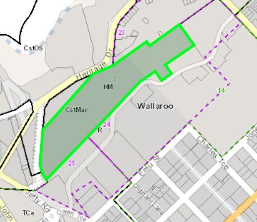
Local Heritage Places
In the new planning system, all Local Heritage Places (approx. 7,250) currently identified in council
Development Plans will transfer directly into the new Planning and Design Code under a Local
Heritage Places Overlay. They will continue to be listed in the South Australian Heritage Register, and
will also be accurately mapped in the State Atlas.

Demolition controls will apply in the Local Heritage Places Overlay, with any proposal to demolish a
building/structure to be assessed using a single set of criteria including:

•   the building’s existing heritage values
•   the structural condition of the building and risk to safety.

The important elements of a local heritage place are to be included as part of the listing and assist in
assessing any alterations or additions to these places.

Historic Areas
In the new planning system, all Historic Conservation Zones (over 140 are currently in development
plans) and the like, plus the 11,810 contributory items within these zones will transition into the new
Planning and Design Code under a new Historic Area Overlay. The overlay will apply to local areas
that exhibit discernible historic character worthy of retention.

Historic Area Statements are proposed to be introduced in the Code to help clearly identify and
articulate the key elements of historic importance in a particular area. These will replace Desired
Character Statements in existing Development Plans and are based on existing policy content.
Councils will be able to evolve these statements over time.

Demolition controls will apply in the Historic Area Overlay, with any proposal to demolish a
building/structure to be assessed using a single set of criteria including:

•   the building’s historic characteristics and the ability to reasonably, economically restore it
•   the contribution the building makes to the historic character of the streetscape
•   the structural integrity/condition and the ability to economically restore it.

Some councils (25 of 68) have used ‘contributory items’ to identify specific buildings that contribute to
the character of an area. However, not all councils with Historic Conservation Zones have included
them, and there are vast differences in their demolition and public notification policies. No new
contributory items have been listed since 2012.

In developing the Code, the Commission has proposed that contributory items not be individually
identified in the new planning system because they have no statutory basis; have been applied
inconsistently and processes to identify them have not afforded home owners the rights associated
with the listing of state and local heritage.

The intention of the Historic Area Overlay is to ensure Historic Conservation Zones and the
contributory items within them are subject to a consistent assessment process and the same level of
protection. In this way, the Overlay will bring equality and fairness to land owners regardless of where
they live.

                                                                                                            2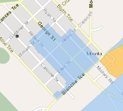
District Council of Copper Coast
The District Council of Copper Coast Development Plan includes a number of zones, subzones and
precincts that comprise heritage areas. Most of the historic areas are contained within the Historic
Mining Zone. These include both State Heritage Areas and historic areas.

The following provides a quick summary of how they have been transitioned.

Policy Area 1 of the Historic Mining Zone:

 Development Plan Precinct         Development Plan Precinct         Planning and Design Code
                                   Name

 1                                 Hamley                            State Heritage Area

 2                                 Hancocks                          State Heritage Area

 3                                 Hughes                            State Heritage Area

 4                                 Mine Management                   State Heritage Area

 5                                 Moonta Mines Buffer               Moonta Mines Buffer
                                                                     (CoCo1)

 6                                 Moonta Station                    State Heritage Area

 7                                 Precipitation Works               State Heritage Area

 8                                 Residential – Moonta Mines        Portion located in State
                                   and North Yelta                   Heritage Area; remainder
                                                                     (CoCo2)

 9                                 Richmans                          State Heritage Area

 10                                Ryans                             State Heritage Area

 11                                Taylors                           State Heritage Area

 12                                Yelta Slimes                      State Heritage Area

Policy Area 2 of the Historic Mining Zone:

 Development Plan Precinct         Development Plan Precinct         Planning and Design Code
                                   Name

 13                                Cornish Village                   Cornish Village
                                                                     (CoCo3)

 14                                Matta Museum                      Matta Museum
                                                                     (CoCo4)

 15                                Mines Buffer                      Mines Buffer
                                                                     (CoCo5)

                                                                                                       3
Development Plan Precinct Development Plan Precinct Planning and Design Code
Name
16 Mines Industry Mines Industry
(CoCo6)
17 Residential Kadina Residential Kadina
(CoCo7)
18 Residential Matta Residential Matta
(CoCo8)
Other Zones
Development Plan Zone Development Plan Policy Planning and Design Code
Area
Town Centre Policy area 10 - Moonta Moonta Town Centre Historic
Area Statement (CoCo9)
Historic Mining Zone Policy Area 3 – Wallaroo Town Wallaroo Town Smelter
(CoCo10)
Town Centre Zone, Wallaroo Policy Area 11 Wallaroo Town Centre
(CoCo11)
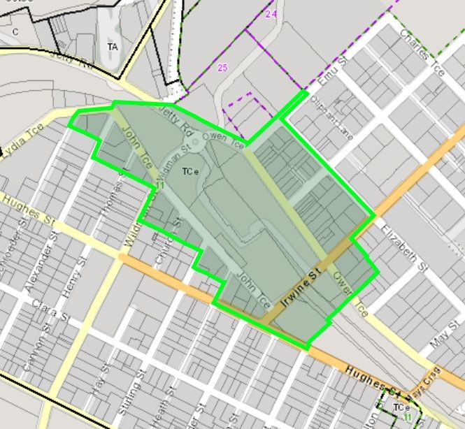
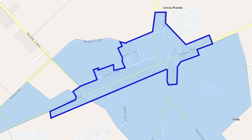
4Moonta Mines Buffer Historic Area Statement (CoCo1)
Historic Area Overlays identify areas that comprise unified, consistent streetscape characteristics of
an identifiable historic, economic or social theme associated with an earlier era of development. They
comprise built form characteristics, and at times natural features and sub-division patterns that provide
a legible connection to the historic development of the local area. Development within the Overlay will
preserve these attributes.
The redevelopment of existing places, through refurbishment or adaptive reuse, will maintain, and
where possible enhance or reinforce, this unified, consistent historic streetscape character.
New development will be generally limited to the replacement of places that either do not contribute
towards this unified, consistent historic streetscape character, or towards the rear of sites that do, so
as to not adversely impact the legibility and interpretation of the prevailing historic, economic or social
themes as viewed from the public realm.
CoCo1 – Buffer (blue
area)
5Eras and themes Rural.
Setting and public realm Open rural character that provides a setting for the historic mining
features features to be read and interpreted.
6Residential North Yelta (CoCo2)
Historic Area Overlays identify areas that comprise unified, consistent streetscape characteristics of
an identifiable historic, economic or social theme associated with an earlier era of development. They
comprise built form characteristics, and at times natural features and sub-division patterns that provide
a legible connection to the historic development of the local area. Development within the Overlay will
preserve these attributes.
The redevelopment of existing places, through refurbishment or adaptive reuse, will maintain, and
where possible enhance or reinforce, this unified, consistent historic streetscape character.
New development will be generally limited to the replacement of places that either do not contribute
towards this unified, consistent historic streetscape character, or towards the rear of sites that do, so
as to not adversely impact the legibility and interpretation of the prevailing historic, economic or social
themes as viewed from the public realm.
7Eras and themes Late 19th century and early 20th century.
Architectural features Within North Yelta, miners’ cottages of simple design with skillion-
roofed lean-to additions at the rear and verandas to the front.
Materials Rendered stone.
Setting and public realm Within North Yelta buildings sited in a linear fashion along Kadina
features Road, framing the entrance to Moonta.
8Cornish Village Historic Area Statement (CoCo3)
Historic Area Overlays identify areas that comprise unified, consistent streetscape characteristics of
an identifiable historic, economic or social theme associated with an earlier era of development. They
comprise built form characteristics, and at times natural features and sub-division patterns that provide
a legible connection to the historic development of the local area. Development within the Overlay will
preserve these attributes.
The redevelopment of existing places, through refurbishment or adaptive reuse, will maintain, and
where possible enhance or reinforce, this unified, consistent historic streetscape character.
New development will be generally limited to the replacement of places that either do not contribute
towards this unified, consistent historic streetscape character, or towards the rear of sites that do, so
as to not adversely impact the legibility and interpretation of the prevailing historic, economic or social
themes as viewed from the public realm.
9Eras and themes Late 19th century and early 20th century.
Architectural features The following are of particular value:
mine manager’s residences south of Newland Terrace
semi-detached dwellings east of Stirling Terrace
rotunda
former Institute Building
Setting and public realm Village setting.
features
10Matta Museum Historic Area Statement (CoCo4)
Historic Area Overlays identify areas that comprise unified, consistent streetscape characteristics of
an identifiable historic, economic or social theme associated with an earlier era of development. They
comprise built form characteristics, and at times natural features and sub-division patterns that provide
a legible connection to the historic development of the local area. Development within the Overlay will
preserve these attributes.
The redevelopment of existing places, through refurbishment or adaptive reuse, will maintain, and
where possible enhance or reinforce, this unified, consistent historic streetscape character.
New development will be generally limited to the replacement of places that either do not contribute
towards this unified, consistent historic streetscape character, or towards the rear of sites that do, so
as to not adversely impact the legibility and interpretation of the prevailing historic, economic or social
themes as viewed from the public realm.
11Eras and themes Mining.
Architectural features The Matta Mine is of particular value. Rural outbuildings.
Setting and public realm Open rural character.
features
12Mines Buffer Historic Area Statement (CoCo5)
Historic Area Overlays identify areas that comprise unified, consistent streetscape characteristics of
an identifiable historic, economic or social theme associated with an earlier era of development. They
comprise built form characteristics, and at times natural features and sub-division patterns that provide
a legible connection to the historic development of the local area. Development within the Overlay will
preserve these attributes.
The redevelopment of existing places, through refurbishment or adaptive reuse, will maintain, and
where possible enhance or reinforce, this unified, consistent historic streetscape character.
New development will be generally limited to the replacement of places that either do not contribute
towards this unified, consistent historic streetscape character, or towards the rear of sites that do, so
as to not adversely impact the legibility and interpretation of the prevailing historic, economic or social
themes as viewed from the public realm.
13Eras and themes Rural.
Setting and public realm Open rural character that provides a setting for the historic mining
features features to be read and interpreted.
14Mines Industry Historic Area Statement (CoCo6)
Historic Area Overlays identify areas that comprise unified, consistent streetscape characteristics of
an identifiable historic, economic or social theme associated with an earlier era of development. They
comprise built form characteristics, and at times natural features and sub-division patterns that provide
a legible connection to the historic development of the local area. Development within the Overlay will
preserve these attributes.
The redevelopment of existing places, through refurbishment or adaptive reuse, will maintain, and
where possible enhance or reinforce, this unified, consistent historic streetscape character.
New development will be generally limited to the replacement of places that either do not contribute
towards this unified, consistent historic streetscape character, or towards the rear of sites that do, so
as to not adversely impact the legibility and interpretation of the prevailing historic, economic or social
themes as viewed from the public realm.
15Eras and themes Mining and industry.
Architectural features Industrial artefacts of the Wallaroo Mines, including engine houses,
power plants, mines, settling pools and powder magazines, are of
particular value.
16Residential Kadina Historic Area Statement (CoCo7)
Historic Area Overlays identify areas that comprise unified, consistent streetscape characteristics of
an identifiable historic, economic or social theme associated with an earlier era of development. They
comprise built form characteristics, and at times natural features and sub-division patterns that provide
a legible connection to the historic development of the local area. Development within the Overlay will
preserve these attributes.
The redevelopment of existing places, through refurbishment or adaptive reuse, will maintain, and
where possible enhance or reinforce, this unified, consistent historic streetscape character.
New development will be generally limited to the replacement of places that either do not contribute
towards this unified, consistent historic streetscape character, or towards the rear of sites that do, so
as to not adversely impact the legibility and interpretation of the prevailing historic, economic or social
themes as viewed from the public realm.
17Eras and themes Late 19th and early 20th century. Colonial character.
Architectural features Simple miner’s cottages through to substantial villa-style dwellings.
18Residential Matta Historic Area Statement (CoCo8)
Historic Area Overlays identify areas that comprise unified, consistent streetscape characteristics of
an identifiable historic, economic or social theme associated with an earlier era of development. They
comprise built form characteristics, and at times natural features and sub-division patterns that provide
a legible connection to the historic development of the local area. Development within the Overlay will
preserve these attributes.
The redevelopment of existing places, through refurbishment or adaptive reuse, will maintain, and
where possible enhance or reinforce, this unified, consistent historic streetscape character.
New development will be generally limited to the replacement of places that either do not contribute
towards this unified, consistent historic streetscape character, or towards the rear of sites that do, so
as to not adversely impact the legibility and interpretation of the prevailing historic, economic or social
themes as viewed from the public realm.
19Eras and themes Late 19th century and early 20th century.
Architectural features Remnants of miners’ dwellings and cottages are of particular value.
20Wallaroo Town Smelter Historic Area Statement (CoCo9)
Historic Area Overlays identify areas that comprise unified, consistent streetscape characteristics of
an identifiable historic, economic or social theme associated with an earlier era of development. They
comprise built form characteristics, and at times natural features and sub-division patterns that provide
a legible connection to the historic development of the local area. Development within the Overlay will
preserve these attributes.
The redevelopment of existing places, through refurbishment or adaptive reuse, will maintain, and
where possible enhance or reinforce, this unified, consistent historic streetscape character.
New development will be generally limited to the replacement of places that either do not contribute
towards this unified, consistent historic streetscape character, or towards the rear of sites that do, so
as to not adversely impact the legibility and interpretation of the prevailing historic, economic or social
themes as viewed from the public realm.
21Eras and themes 1861-1926. Industry.
Architectural features The Wallaroo Smelter Site, which includes the Hughes Chimney
Stack, Wallaroo Seafarers' Centre (former Smelters' offices), ruins
of various structures and slag heaps, are of particular value.
Materials Brick, stone and concrete.
Setting and public realm Open character dominated by the Hughes Chimney Stack.
features
22Wallaroo Town Centre Historic Area Statement (CoCo10)
Historic Area Overlays identify areas that comprise unified, consistent streetscape characteristics of
an identifiable historic, economic or social theme associated with an earlier era of development. They
comprise built form characteristics, and at times natural features and sub-division patterns that provide
a legible connection to the historic development of the local area. Development within the Overlay will
preserve these attributes.
The redevelopment of existing places, through refurbishment or adaptive reuse, will maintain, and
where possible enhance or reinforce, this unified, consistent historic streetscape character.
New development will be generally limited to the replacement of places that either do not contribute
towards this unified, consistent historic streetscape character, or towards the rear of sites that do, so
as to not adversely impact the legibility and interpretation of the prevailing historic, economic or social
themes as viewed from the public realm.
23Eras and themes A civic, commercial and retail mix with a strong relationship to
mining, industry and railway.
Allotments and sub-division Traditional grid with wide streets.
patterns
Architectural features Miners’ cottages. Simple casement windows. Low scale simple
gable and hipped roofs. Roof pitches between 25 and 40 degrees.
Verandas overhanging footpath on Owen Terrace. Traditional
railway architecture – the former Wallaroo Train station of particular
value.
Building height Single storey residential and retail buildings. Two storey civic
buildings (Wallaroo Town Hall).
Materials Local stone, limestone, masonry and corrugated galvanised iron.
Fencing Low, open fencing.
Setting and public realm Consistent front setbacks and a strong building line with little
features interruption. Landscaping forward of buildings.
24Moonta Town Centre Historic Area Statement (CoCo11)
Historic Area Overlays identify areas that comprise unified, consistent streetscape characteristics of
an identifiable historic, economic or social theme associated with an earlier era of development. They
comprise built form characteristics, and at times natural features and sub-division patterns that provide
a legible connection to the historic development of the local area. Development within the Overlay will
preserve these attributes.
The redevelopment of existing places, through refurbishment or adaptive reuse, will maintain, and
where possible enhance or reinforce, this unified, consistent historic streetscape character.
New development will be generally limited to the replacement of places that either do not contribute
towards this unified, consistent historic streetscape character, or towards the rear of sites that do, so
as to not adversely impact the legibility and interpretation of the prevailing historic, economic or social
themes as viewed from the public realm.
25Eras and themes 19th century idyllic historic main street with a mix of civic,
commercial and retail activities.
Allotments and subdivision Traditional grid.
patterns
Architectural features Two-storey stone buildings exhibiting refined detailing, ornate roof
elements and a high-level of craftsmanship are of particular value.
Extensive glazing and double-hung doors and windows in street
facing frontages of non-residential buildings. Windows
emphasised by framing. Symmetrical fronted and vertically
proportioned dwellings. Hipped roof forms with pitches between
30-45 degrees. Sloping verandas overhanging footpaths to the
street, connected to shops in particular.
Building height Predominantly single storey where residential or retail - two
storeys associated with grand, civic or commercial activities (town
hall, hotels).
Materials Local stone, masonry, corrugated iron sheet roofing, stone and
timber framed windows and doors, timber veranda posts and brick
chimneys.
Fencing Low timber and stone fences not exceeding 1.2m.
Setting and public realm Wide streets, a prominent central public square framed by
features significant public buildings and limited landscaping. Buildings
square to and on street alignments. Minimal breaks between
buildings – except where access to the rear of a site is provided.
Dwellings are consistently setback further from the street.
26You can also read