DRAFT FORTUNESTOWN LANE / GARTER LANE - LOCAL AREA PLAN OCTOBER 2008 SOUTHDUBLINCOUNTYCOUNCIL PLANNINGDEPARTMENT OCTOBER2008 1 - SOUTH DUBLIN ...
←
→
Page content transcription
If your browser does not render page correctly, please read the page content below
DRAFT Fortunestown Lane / Garter Lane
Local Area Plan
October 2008
                                        South Dublin County Council   Planning Department   October 2008   1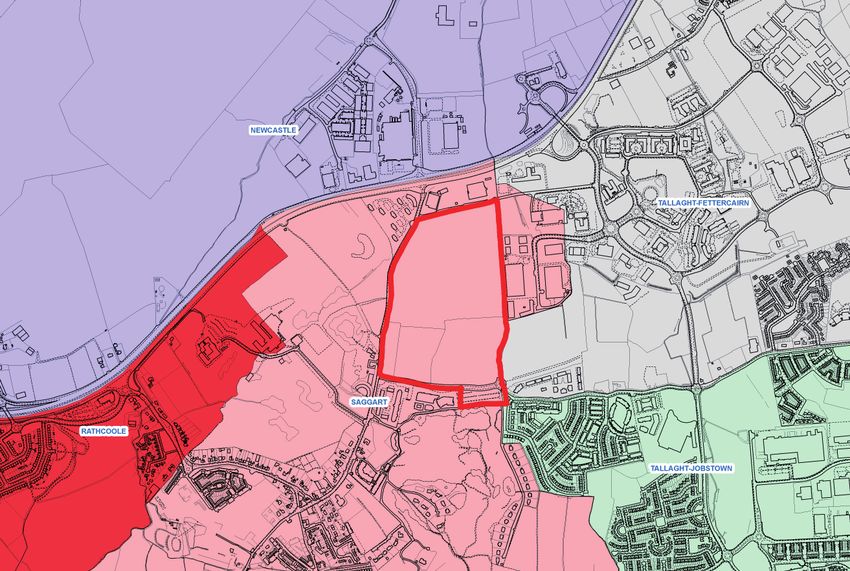
1.1     Background
                                                                                          1.2     What is a Local Area Plan
                                                                                          1.3     Public Consultation

                                                                                          3.1     Strategic Context

                                                                                          4.1     Plan Area
                                                                                          4.1.1   Land use
                                                                                          4.1.2   Historical use
                                                                                          4.1.3   Site analysis
                                                                                          4.1.4   Landscape/Urban design analysis
                                                                                          4.1.5   Movement analysis
                                                                                          4.1.6   Population/Demographics
                                                                                          4.1.7   Community and Social Infrastructure

                                                                                          5.1     A New Neighbourhood
                                                                                          5.2     Open Space
                                                                                          5.3     Movement
                                                                                          5.4     Urban Design
                                                                                          5.5     Community and Social Infrastructure
                                                                                          5.6     Home Zones
                                                                                          5.7     Infrastructure
                                                                                          5.8     Employment and Retail
                                                                                          5.9     Energy Efficiency

                                                                                                  Appendices

                                                                                          A       Development Management Checklist
Michael Kenny.................................................... Senior Planner          B       Strategic Environmental Assessment
Louise McGauran............................................... Senior Executive Planner
Olwyn James....................................................... Executive Planner
Padraic Larkin.....................................................Chief Technician
John Lockhart..................................................... Executive Technician

Stephen Rhys-Thomas....................................... Senior Executive Planner
Clare Doyle.......................................................... Assistant Planner
Majella Keating................................................... Assistant Planner
David McIntyre................................................... Technician Grade 1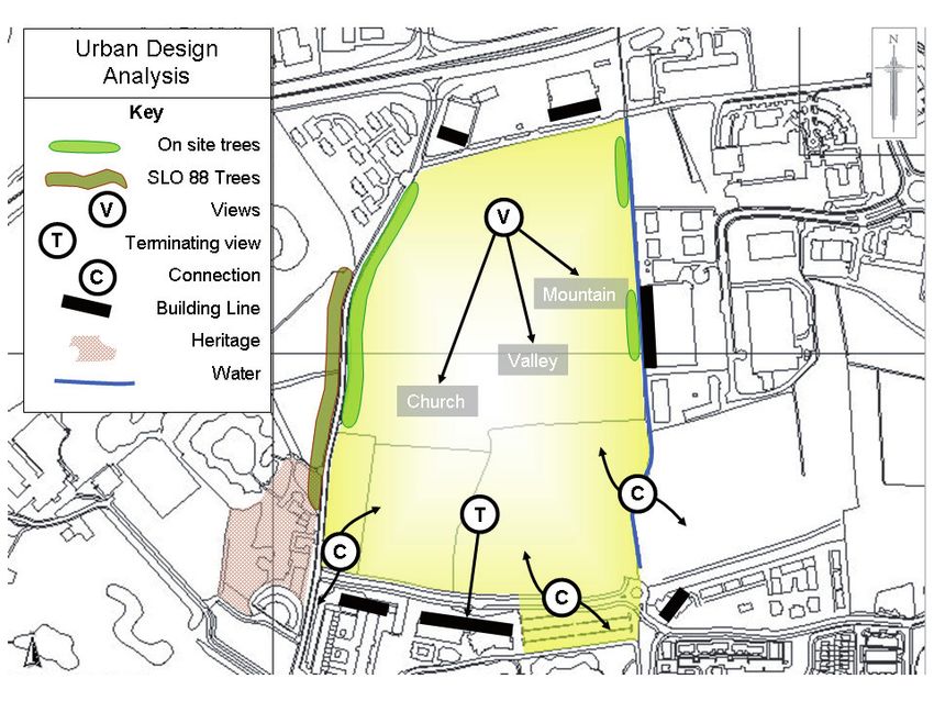
1.0 Introduction

                                                            1.1 Background.

                                                            The Saggart/Citywest/Fortunestown Lane area has undergone significant
                                                            development in the last ten years with the landscape changing from rural to out-
                                                            er suburban in character. On 13th November 2006 the members of South Dub-
                                                            lin County Council adopted Variation No.2 of the County Development Plan
                                                            which rezoned 31 hectares (76 acres) of land at the junction of Fortunestown
                                                            Lane and Garter Lane, Saggart from objective ‘GB’ ‘To preserve a “Green belt”
                                                            between development areas’ to Objective A1 – ‘To provide for new residential
                                                            communities in accordance with approved action plans’. In addition Specific
                                                            Local Objective No. 124 was inserted into the Development Plan as follows;

                                                            “Fortunestown Lane and Garter Lane, Saggart – Development of Lands.

                                                            Development on the lands at Fortunestown Lane and Garter Lane, Saggart, will
                                                            be in accordance with the following:
                                                            a)        Be subject to a micro Local Area Plan;
                                                            b)        Planning permission for development in accordance with an
                                                                      approved area plan will not be issued until such time as the
                                                                      construction of the LUAS extension to Citywest / Saggart has
                                                                      commenced;
                                                            c)        Not less than 20 acres of land to be reserved at this location for
                                                                      community facilities incorporating all weather pitches, community
                                                                      buildings, school site, a park and ride facility and other uses that will
                                                                      significantly benefit the community that may be identified through
                                                                      the Local Area Plan consultation process,
                                                            d)        That the residential densities be reviewed to ensure a mix of dwelling
                                                                      types including low density, high density and medium density
                                                                      residential development;
                                                            e)        The phasing of development at this location to be carried out in a
                                                                      sustainable way ensuring that facilities are built in tandem with
                                                                      housing and not at a later stage;
                                                            f)        15% of the residential development to be reserved to provide for
                                                                      social housing.”

                                                            This Local Area Plan arises from the decision from the Council to re-zone the
                                                            lands and to prepare a plan for the lands.
Fig. 1 Local Area Plan lands in regional/county context
                                                            On 16th June 2008 An Bord Pleanala granted the rail order for the extension
                                                            of the LUAS Line A1 from Belgard to Saggart. The proposed extension of the
                                                            LUAS Line and the preparation of a Local Area Plan create a unique opportunity
                                                            for the development of a high quality new neighbourhood in the Fortunestown
                                                            Lane and Garter Lane area.

                              South Dublin County Council         Planning Department                       October 2008                    3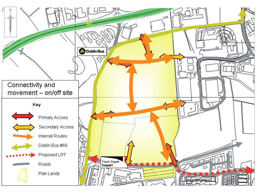
DRAFT Fortunestown Lane / Garter Lane Local Area Plan

                                                                                          The Elected Members have six weeks in which to consider the Manager’s Re-
                                                                                          port and then make or not make the Plan. Any material amendments to the
                                                                                          Draft Plan must be put back on public display for 4 weeks and this sets in train
                                                                                          a similar process for a Manager’s Report and consideration of this report by the
                                                                                          Elected Members.

                                                                                          This Local Area Plan will remain in force for a period of six years following its
                                                                                          adoption unless amended or reworked by the Council.

                                                                                          1.3 Pre Draft Plan Public Consultation.

                                                                                          As noted above there is a statutory obligation on a local authority to carry out
                                                                                          consultation prior to preparing a Draft Local Area Plan. The Council em-
                                                                                          barked on a series of consultations prior to the preparation of this draft plan
                                                                                          as follows;
                                                                                                                                                                               Figs 3 & 4       Public Information Day, Citywest Shopping Centre
    Fig. 2   Photomontage of Luas line A1 in vicinity of plan lands. Source: RPA          •Notification of the intention to prepare a Draft Local Area Plan and the inten-
                                                                                          tion to engage in consultation was advertised in the Irish Times on 14th April       South Dublin County Council has taken into account the wide ranging issues
    This document sets out the area plan in draft form for public consultation with       2008.                                                                                raised in the preparation of this Local Area Plan.
    all relevant parties; elected members, stake holders, prescribed bodies and the       •An issues paper was prepared and placed on display for a six week period
    residents of the area.                                                                in the Council’s offices and libraries. This paper was also available on www.
                                                                                          southdublin .ie.
    The EU Directive on Strategic Environmental Assessment (SEA) requires all             •Notification of the intention to prepare a Draft Local Area Plan was also sent to
    European Union Member States to systematically evaluate the likely significant        a variety of stakeholders in the West Tallaght/Fortunestown/Citywest/Saggart
    effects of implementing a plan prior to it adoption. Having consulted with the        area.
    prescribed bodies the Council considers that the draft plan is not likely to have     •A public information day was held in Citywest Shopping Centre, Citywest on
    significant effects on the environment (see Appendix C for further details on         8th May 2008. Some 85 people met with Planning Department staff during the
    the SEA process).                                                                     information day.
                                                                                          •An Urban Design workshop with plan area land owners was held.
    1.2 What is a Local Area Plan?
                                                                                          A total of 24 submissions were received on the proposed Local Area Plan and
    A Local Area Plan is a statutory document prepared by the Planning Authority          a significant number of issues concerning those living and working in the area
    in accordance with the requirements of Sections 18 - 20 of the Planning and           adjacent to the plan lands were highlighted. A report summarising the issues
    Development Act 2000 (as amended). A Local Area Plan consists of a writ-              raised and the Managers response was prepared and is available in hardcopy
    ten statement and plans and once adopted by the members of the Council the            and on www.southdublin.ie.
    Planning Authority and An Bord Pleanala must have regard to the Plan when
    determining planning applications in the area covered by the Plan.                    The issues raised are summarised in Table 1.

    Prior to preparing a Local Area Plan the Council must take whatever steps it          Table 1: Issues - Percentage of all submissions.
    considers necessary to consult the public including consultations with                                                                   Percentage of all
    local residents, public sector agencies, community groups and businesses in            Issue
                                                                                                                                             submissions
    the area.                                                                              Provision of a primary school.                                             50%
                                                                                           Provision      of   recreational/community
    When the draft plan is prepared it must be placed on display for six weeks                                                                                        45%
                                                                                           facilities.
    during which time submissions can be made by interested parties and the                Traffic/Transport/Roads/Park and Ride.                                     33%
    public. Not later then twelve weeks after the commencement of the public dis-          Land use.                                                                  29%
    play a report is prepared on the submissions received during the display
                                                                                           Height/Density/urban design.                                               12%
    period. This report will include the response and recommendations of the
    County Manager on these submissions.                                                   Environmental.                                                             12%
                                                                                           Other.                                                                     12%

4                  South Dublin County Council                      Planning Department             October 2008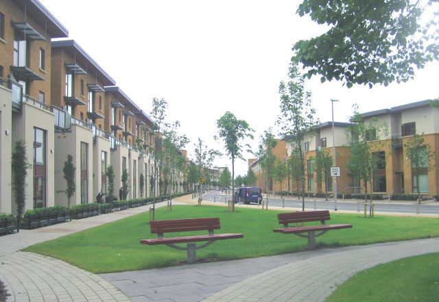
2.0 A vision for Fortunestown Lane/Garter lane                                   Table 2: Strategic Context.

The vision for the plan lands arises from their location in the county and the   Policy Context Policy Document                             Policies                                                Issue for Local Area Plan
need to integrate development on the plan lands with the existing village of
Saggart and with development in the general Citywest/Fortunestown area.                                                                     8 Characteristics of a Sustainable Community.
                                                                                                                                            -       Active, Inclusive and Safe.
Vision                                                                                                                                      -       Well Run.
•      a vibrant sustainable new neighbourhood with reduced dependence                                                                      -       Well Connected.                                 Opportunity to develop lands in accordance with
       on the private car.                                                       European          Bristol Accord                           -       Well Served.                                    these principles.
•      a sustainable urban neighbourhood with its own distinct character                                                                    -       Environmentally Sensitive.
       combined with high quality public realm and the provision of                                                                         -       Thriving.
       recreational facilities and open space.                                                                                              -       Well designed and Built.
•      an extension to the village of Saggart and the developing new areas of                                                               -       Fair for Everyone.
       Cooldown Commons and Carrigmore.
                                                                                                                                                                                                    The Plan lands are an extension to Saggart village
The aim of this Local Area Plan is to support this vision by providing the                                                                  Consolidation of the Greater Dublin Area.               and also the Fortunestown area and are located in
framework within which new development can take place.                           National          National Spatial Strategy 2002 – 2020.   Better quality of life.                                 an areas earmarked for consolidation of develop-
                                                                                                                                            Addressing imbalances.                                  ment.
3.0 Policy and Strategic context.

The land at Fortunestown Lane/Garter Lane sits within a larger area                                National Development Plan – 2007 Sustainability.                                                 Opportunity for sustainable development on the
comprising West Tallaght, Fortunestown, Citywest and Saggart. The area has                         – 2013.                                                                                          plan lands.
undergone significant change over the last ten years and the proposed LUAS
line extension creates a unique opportunity to further develop, enhance and
consolidate the area.                                                                                                                     Promotes an integration of land use and transport         Need for an integrated approach to urban develop-
                                                                                                   National Climate Change Strategy 2007. policies coupled with appropriate technologies to         ment, increase use of public transport and use of
                                                                                                                                          bring about a change in Ireland’s contribution to climate greener technologies in building.
This Local Area Plan has been informed by a hierarchy of European, National,                                                              change.
Regional and Local Planning Policy documents which are outlined in Table 2
below.
                                                                                                   Sustainable Residential Development in Sets out 12 criteria to be taken into account in designing Feeds into Urban Design Section of the Local Area
                                                                                                   Urban Areas, February 2008 (Draft).    residential areas.                                         Plan.

                                                                                                   Urban Design Manual, A Best Practice Focuses on Local Area Plans containing policies which Creation of sustainable residential developments.
                                                                                                   Guide, February 2008 (Draft).        underpin the creation of sustainable residential develop-
                                                                                                                                        ments.

                                                                                                   Sustainable Urban Housing:               Promotion of sustainable apartments which can be used Need to address apartment size, mix and design.
                                                                                                   Design Standards for New Apartments.     at all stages on the life cycle.
                                                                                                   September 2007.

                                                                                                   Childcare Facilities
                                                                                                   Guidelines for Planning Authorities.     Framework for guiding childcare developments.           Need to address childcare issues.
                                                                                                   June 2001.

                                                                                                                                    South Dublin County Council                  Planning Department                  October 2008                  5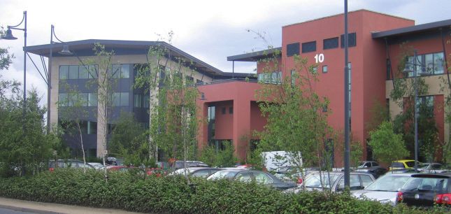
DRAFT Fortunestown Lane / Garter Lane Local Area Plan
4.0 Plan Area Appraisal.
Policy Content Policy Content Policies Issues for Local Area Plan
Sets out a strategy for the Greater Dublin Area based on The plan lands are located in the Metropolitan
Regional Regional Planning Guidelines, Greater a city region, reduction of population loss to its hin- Area and therefore should be developed in line
Dublin Area 2004 – 2016. terland, improvement of modal shift to use of public with enhanced public transport facilities.
transport.
Dublin Transportation Office, A Plat- Sets out a long term transportation strategy for the The plan should aim to be in accordance with the
form for Change, Strategy 2000 – 2016. Greater Dublin Area. DTO strategy. New strategy will extend to 2030.
Strategy currently under review.
Waste Management Plan for the Dublin Sets targets for management and minimisation of waste. The plan should aim to meet the requirement of
Region 2005 – 2010. this plan.
Retail Planning Strategy for the Greater Proposes a five year hierarchy of retail centres. (Current- Plan should address retailing and whether it is
Dublin Area, Nov 2001. ly under review and due for adoption September 2008). required.
Land zoned Objective A1 – To provide for new residen- SLO88. The plan should address the retention of
tial communities in accordance with approved action trees on Garter Lane.
plans. SLO 124 sets out a number of issues which must
South Dublin County Council, Develop- SLO 88. Enhance rural aspect of approach to Saggart by be addressed in the Local Area Plan.
Local ment Plan 2004 - 2010 including Varia- retention of trees on Garter Lane. SLO 100. The plan should address the plan lands’
tion No. 2. SLO 100 Saggart – Local Area Plan. relationship with Saggart Village.
SLO 124;
Fortunestown Lane and Garter Lane, Saggart – Develop-
ment of Lands.
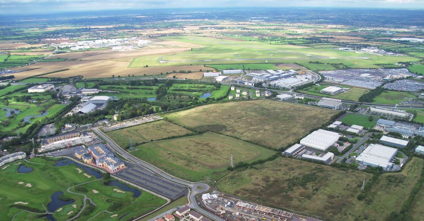
Cumulative impact of development and provi- Fig. 5 Aerial photograph showing plan lands.
Cooldown Commons Area Plan, July Set out an urban design framework for 27 hectares of sion of services.
2006 land to the east of the plan lands. Connectivity between the plan lands and
Cooldown Commons Area Plan Land. 4.1 Plan Area.
Saggart Action Area Plan, September Addressed A1 zoned lands in Saggart village. The The plan land comprises 75 acres (31 hectares) of land to the north east of Saggart
Cumulative impact and provision of services.
2000 development of these lands is almost completed. Village. The lands are bounded by Garter Lane to the west, Bianconi Avenue
(running through the City West Business Park) to the north, Fortunestown
Lane to the south (except for a small portion of the plan lands which is to the
Mill Road, Saggart Area Plan, Sets out an urban framework for development of lands south of Fortunestown Lane) and Citywest Business Campus and Cooldown
Provision of services in area.
on Mill Road Commons Area Plan lands to the east.
4.1.1 Land use.
The majority of the plan lands are currently undeveloped and open in char-
acter, consisting of grassland with some intact and remnant hedgerows and
ditches which formed old field boundaries. A tributary of the Camac River
6 South Dublin County Council Planning Department October 2008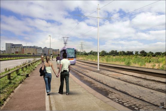
flows along the eastern boundary of the site. There are some mature trees along     of South West Dublin and are strategically located within close proximity to
Garter Lane. The very small portion of the plan land which lies to the south of     Tallaght Town Centre and the N7 Naas Road, which acts as a gateway into
Fortunestown Lane has been developed as a surface car park.                         Dublin city.

                                                                                    Saggart derives its name from Saint Mosacre who reputedly founded a monas-
                                                                                    tery here in the latter half of the 7th Century. Due to its location on good land
                                                                                    and established infrastructure Saggart was chosen, in the 12th Century, to be
                                                                                    one of the four county Dublin royal manors of the Archbishop of Dublin. Hav-
                                                                                    ing suffered attack as a result of its position in the Pale boundary over a number
                                                                                    of centuries, evidence of the fortification of Saggart still exists in the shape of a
                                                                                    15th century Tower House within the curtilage of Tassagart House along Gar-
                                                                                    ter Lane. The development of Swiftbrook Mills in the early 1790’s established
                                                                                    a strong economic base for Saggart around which the village developed. The
                                                                                    McDonnell family, who for a period ran the Paper Mill, were major benefactors
                                                                                    to the building of Saggart Church in the 1800’s.

                                                                                    The Saggart Action Area Plan, adopted by the Council in April 2000 set out a
Fig. 6   View of plan lands from Fortunestown Lane                                  framework for development lands within Saggart, which acted as an extension
                                                                                    to the village. The Plan provided for the provision of high quality residential de-
From the Plan lands there are extensive views of the foothills of the Dublin and    velopment, public amenity spaces, community facilities and for the protection
Wicklow Mountains, including the Slade Valley.                                      of the historical landscape of the village. The expansion of the Fortunestown
                                                                                    and Citywest areas reinforces the importance of retaining the character of the
To the South East of the plan lands is the District Centre of Citywest Shop-        village.
ping Centre which is located at the junction of Fortunestown Lane and the
N82. Considerable residential development has taken place around this Dis-          The built form of West Tallaght in which Fortunestown borders is predomi-
trict Centre with apartment blocks up to four storeys and a variety of different    nantly low rise, low density residential estates which were built largely by
house types.                                                                        Dublin Corporation and Dublin County Council over the last 30 years. Pri-
                                                                                    vate residential development began in the Fortunestown area in the 1990’s. The
To the north and east of the plan lands lies the Citywest Business Campus. The      Fortunestown Action Area Plan, adopted by South Dublin County Council in
employment uses in the Business Park range from high technology industries          May 1999 directed the development of lands for residential, local centre and
to distribution and logistics enterprises. To the west of the plan lands lies the   community uses. A number of large private and local authority housing de-
Citywest Hotel and Golf course and further south is located Saggart Village.        velopments as well as retail developments and the industrial developments in
                                                                                    Citywest have shaped the Fortunestown area as it exists today.

Fig.7    Tree lined Garter Lane      Fig. 8   Offices in Citywest

4.1.2    Historical use.

The Plan lands lie at a junction between the historic village of Saggart and
the newly emerging residential and business communities of Fortunestown
and City West. Saggart and Fortunestown form part of the wider hinterland

                                                                                                                                           South Dublin County Council      Planning Department   October 2008   7
DRAFT Fortunestown Lane / Garter Lane Local Area Plan
4.1.3 Site Analysis. Table 3 - Opportunities and constraints.
Theme Issue Description Sensitivity and Significance Implication for Development of the Lands
A summary of key constraints and opportunities in relation to the plan lands
is set out in Table 3. Biodiversity Audit should be carried out prior to
Biodiversity. Trees, stream. Environmental interest. development. Layout may need to change in response to
audit.
Tsaggart House adjacent
to lands 2 protected Outside of plan lands but development on plan lands should
Protected Structures. Historic Interest.
structures. be sensitive to the setting of protected structures.
Garter Lane.
Protected Trees. Objective to protect trees. Opportunity to create ‘boulevard effect’ mirroring trees.
Conservation
Zone of Archaeological
Potential of Saggart Surveys required to be taken by competent personnel to
Record of Protected extends over a small No visible surface evidence of site determine significance to commencement of development
Monuments. portion of the plan 021-034. and can be dealt with during the normal planning process.
lands- No. 021-034. Appropriate management Strategies to be agreed.
River flows through
Potential for river feature to be incorporated into the
Camac River. portion of the site Element of site.
development. Protect from pollution.
No increase in rate of surface water
Surface Water Drainage. Surface water drainage Development Management Checklist- SUDS.
discharge from the site permissible
Tunnelling will be required under
Capacity for the Plan Tunnelling will be required under the N7 and connection
the N7 and connection into the
Foul Water Drainage. lands exists. into the Camac Valley Sewer.
Camac Valley Sewer.
Capacity exists.
Water Supply. None. Connection to existing watermains.
Infrastructure
110kV line runs across Planning application to
Electricity. site. underground line has been Under grounding of line will enhance appearance of area.
submitted to Council.
BGE gas transmission
pipe line passes to east
Gas. None. None.
of Plan lands.
Luas A1 extension to
Development at medium to high density acceptable within
Saggart- End of line
Significant enhancement of 400m boundary of the lands.
Luas Extension. located along the south
accessibility. Reservation required along Garter Lane for possible further
of the lands.
expansion.
Provision for park
and ride included in
Park and Ride. None. Provision of Park and ride facilities to be examined.
Variation No.2.
Transport
Existing route along
Garter Lane and
Dublin Bus. Enhancement of accessibility. Opportunity to provide increased bus provision.
Bianconi Avenue.
Significant enhancement of
Outer Ring Road. Completed July 2008. Local Traffic will be catered for on local roads.
accessibility.
Construction will
commence early 2009
Significant enhancement of
Embankment Road. and be completed in Local Traffic will be catered for on local roads.
accessibility.
mid 2010.
8 South Dublin County Council Planning Department October 2008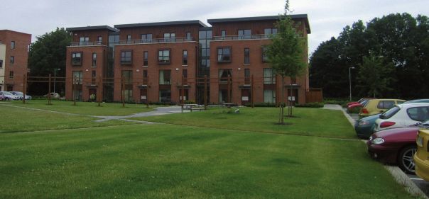
Theme Issue Description Sensitivity and Significance Implication for Development of the Lands
Guidance on heights and design to take account of existing
Mix of building heritage New developments sensitive to
development.
Urban Design Interface with and new developments protected structures and also in
New development must accord with county settlement
Existing Development. adjacent. line with the surrounding built
strategy.
environment.
Density must accord with edge of city location.
Protected trees and
Opportunity to mirror the
avenue of aesthetic
Garter Lane. protected trees on the lands and Design guidance on open space adjacent to Garter Lane.
value.
create a boulevard.
Historic and cultural
Importance of creating
value in Saggart Village Design guidance on built form and layout with reference
Saggart Village. development which is sympathetic
adjacent to lands. to the village.
to the village environment.
Urban Design
Views to Slade Valley or
Opportunity to protect and
important aesthetic and Design guidance on protection of views and overall
Views to Slade Valley. incorporate views into the plan
environmental amenity. design.
lands.
Aeronautical Restrictions. Casement Aerodrome. Portion of plan within inner zone. Height restrictions will apply to portion within zone.
Development lands in
Dual land ownership-
Phasing required to deliver key infrastructure and
Land Use. no existing development Co-ordination of landowners.
community amenities.
on site.
4.1.4 Landscape/Urban design appraisal
Figure 9 provides an urban design analysis of the plan lands. Whilst the lands
are currently not in use there are certain characteristics of the site and sur-
rounds which can be built into the plan strategy.
There are existing views from the plan lands towards the Slade Valley, of the
Church spire in Saggart and of the Dublin Hills. Theses views can be exploited
in the proposed plan layout and strategy.
The existing ‘Golf Village’ provides a terminating view and also a building line
when viewed from the southern portion of the plan lands.
The Boherboy Stream which is a tributary of the Camac skirts the eastern
boundary of the site and offers potential for landscaping.
Specific local Objective No 88 of the County Development Plan aims to en-
hance the rural aspect of the approach to Saggart Village through the retention
of the trees which border Garter Lane. These trees are located to the west of
Garter Lane outside the plan lands. However there are some existing trees on
the plan lands.
There is potential for connections from the plan lands eastwards to the lands
Fig. 9 Urban Design Analysis of Cooldown Commons and Citywest Business Park, northwards to Bianconi
Avenue and southwards to Saggart village.
South Dublin County Council Planning Department October 2008 9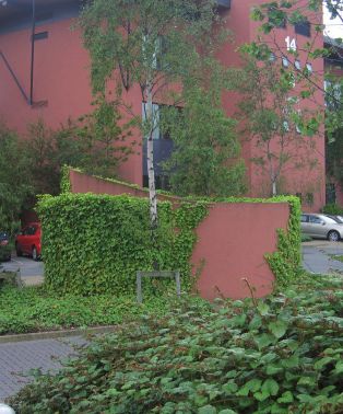
DRAFT Fortunestown Lane / Garter Lane Local Area Plan

     4.1.5    Movement analysis.                                                             The plan lands fall within the DED of Saggart but this DED encompasses a              Table 4 Population change 2002 – 2006 in the area and surrounding
                                                                                             much larger area extending southwards to Brittas and includes the village of          the plan lands.
                                                                                             Saggart and the rural areas of Coolmine and Crooksling. Population trends in
                                                                                             the adjoining DEDs of Tallaght - Jobstown and Tallaght – Fettercairn are also
                                                                                             important as they include the new development areas of Carrigmore and the              DED                    2002        2006              % change
                                                                                             Cooldown Commons Area Plan lands.                                                      Tallaght-Fettercairn   6,488       6,600             1.7%
                                                                                                                                                                                    Tallaght – Jobstown    9,838       12,577            27.8%
                                                                                             Population growth in the environs of the plan lands is higher than in other
                                                                                                                                                                                    Saggart                1,588       2,960             86.4%
                                                                                             areas in the county and reflects their outer suburban location, the availability of
                                                                                             zoned and serviced land and the pressure for development. Having regard to             Total                  17,914      22,137            23.57%
                                                                                             permitted development and zoned land in the area it is likely that the popula-
                                                                                             tion of the general area will continue to increase.

     Fig. 10 Movement Analysis

     There is a need for connectivity internally within the site and externally with
     existing and proposed public transport provision and the existing road net-
     work. Connectivity to the proposed Luas terminus is a key consideration as
     desire lines will run from the Luas stop into the plan lands.

     Routes running east west across the site and north - south would allow ease of
     movement and access to facilities such as the school, open space and the Luas
     stop.

     4.1.6    Population/demographics.
     Census results indicate that the population of South Dublin rose by 8,100 per-
     sons from 238,835 in 2002 to 246,935 in 2006. This represents a percentage
     change of 3.4% compared to 2.1% in Dublin City, 1.2% in Dun Laoghaire Rath-
     down and 22% in Fingal. The national increase was 8.1% in the 2002 – 2006
     period.

     A more detailed analysis at District Electoral Division level indicates that there
     was a decrease in population in the older parts of the county with some DEDs
     in maturer parts of Lucan, Clondalkin, Palmerstown, Templeogue, Terenure,
     Rathfarnham and Tallaght experiencing a decline in numbers since 2002. Ar-
     eas which experienced an increase include the DED of Saggart - where the plan           Fig. 11 Map of DEDs with plan lands outlined in red.
     lands are located - growing by 1,372 persons between 2002 and 2006.

10                    South Dublin County Council                      Planning Department              October 2008
A report prepared on behalf of the Dublin Regional Authority and the Mid East The area is currently served by the South Dublin mobile library unit which
Regional Authority increased the projected housing allocation in the South serves Rathcoole every Monday, Saggart on alternate Thursdays and Brookfield
Dublin County area to 46,459 additional units by 2016. every Wednesday. Specific Local Objective Number 2 of the County Develop-
ment Plan states that the library building programme will include a library in
The age profile for the three DEDs listed in Table 4 indicated that the two the Rathcoole/Newcastle area.
Tallaght DEDs are dominated by a youthful population with a very low per-
centage of elderly persons. The percentage of population in the 65 plus age There are a significant number of community groups in the area, both in
category was 7.2 % in the 2006 Census for the county as a whole with Saggart West Tallaght and in Saggart and Rathcoole. The newer development areas
DED having 10.4 % and Tallaght - Fettercairn 1.7% and Tallaght - Jobstown of Citywest have few community facilities such as community centres, play-
1.3%. 33% of the population in Tallaght-Fettercairn was in the 0 – 15 age cat- grounds, playing pitches. However it is noted that there is a current applica-
egory as were 31% of the population in the Tallaght-Jobstown DED compared tion (register reference SD08A/0347) for the provision of a park on open space
to 21% in the county as a whole. lands to the south west of the Citywest Shopping Centre.
4.1.7 Community and Social Infrastructure. There are a number of religious facilities in the area surrounding the plan
lands.
An audit of existing facilities in the area was carried out in order to identify
shortfalls in the provision of community infrastructure. It was also a key issue
raised at the public consultation information day and in submissions received
during the pre-draft consultation stage. Significant residential development
has occurred in the area surrounding the plan lands where the new residents
require community facilties.
There is currently a primary school, St Marys National School, located on Bo-
herboy Road, Saggart. This school is at capacity and permission has recently
been granted for a temporary school to the rear of the Catholic Church in the
village. A site for a school was designated in the Saggart Action Area Plan,
2000 in what is now the new residential area of the Millrace. This has not been
developed. Figs. 12 & 13 CityWest Business Park
There are two primary schools in Rathcoole, Holy Family National School and There are a number of private and community run childcare facilities in and
Scoil Chronain. There are two post primary schools in the wider catchment around the LAP area. A report entitled “Planning and Childcare Facility study”
of the local area plan lands, St Aidans Community School, Brookfield and was prepared by the Planning Department in February 2008. This study shows
Rathcoole Community School. that between 2002 and 2007 4 childcare facilities were granted planning per-
mission within 500 metres of the plan lands. Three of these facilities are con-
In terms of third level education the Institute of Technology, Tallaght would be structed but not yet operational. The fourth and largest is not yet constructed.
accessible by public transport via the proposed LUAS and the plan lands are
also adjacent to the Tony Ryan Academy for Entrepreneurship developed in There are two Health Service Executive run Health Centres in the general area,
conjunction with Dublin City University at Citywest Business Park. one in Rathcoole and one in Brookfield. There are two GP practices in Saggart
and four in Rathcoole.
South Dublin County Council Planning Department October 2008 11DRAFT Fortunestown Lane / Garter Lane Local Area Plan
5.0 Local Area Plan Strategy.
Fig. 14 Strategy
12 South Dublin County Council Planning Department October 20085.1 A new neighbourhood.
The framework plan illustrates indicative locations for future development and
PO1 It is an objective of the Council to facilitate the development of the blocks. Implied in this strategy is the use of the perimeter block in higher
plan lands as a new urban neighbourhood together with community facili- density areas.
ties and open spaces for the future residents of the plan lands and also for the
existing community adjoining the plan lands. The Local Area Plan seeks to 5.2 Open space.
guide the future development of the area in line with this policy.
The plan strategy aims to provide a network of open spaces throughout the plan
Figure 14 outlines an indicative layout for the plan lands. It should be noted lands which are also integrated with the wider area. A hierarchy of open space
that this indicative layout may change as a result of any findings of the biodiver- types will be available on the plan lands ranging from the civic space at the Luas
sity audit . The key objectives are as follows; terminus, the spine way leading to sporting facilities, more informal open space
and the proposed boulevard on Garter Lane. Fig. 17 & 18 Play areas in Newcastle Lyons and Adamstown.
• The creation of a new residential area accommodating approximate-
ly 1,000 units which takes account of the relationship of the plan lands with One of the stipulations of Variation No. 2 was to provide a minimum of 20
Saggart Village, adjoining protected structures and its outer suburban loca- acres of land for community facilities. This area is reserved to the north of the Specific Local Objective 88 in the County Development Plan states that;
tion. plan lands. This is to ensure an economic use of land with higher density uses
adjacent to the Luas, access from the school to the open space and local access “It is an objective of the plan to enhance the rural aspect of the approach to
• The creation of a new residential area which provides community with the provision of a car park access from Bianconi Avenue. Saggart Village through the retention of the trees which border Garter Lane
and social infrastructure for future residents and the existing community. from Bianconi Avenue (Citywest Business Park) to Fortunestown Lane”
• The creation of a high quality urban realm including a plaza at the South Dublin County Council strongly promotes the concept of sustainability
Luas terminus and a spine walk way linking this area to the community fa- in new residential developments and central to the success of the development
cilities and open space. Mixed uses should be provided at ground floor at the of the plan lands is the provision of facilities to meet the needs of a young popu-
Luas terminus and plaza. lation including play areas and sports facilities.
PO4 It is an objective of the plan to provide a tree lined Avenue/Boul-
• The creation of a new residential area with a sustainable mix of unit In addition to the lands reserved for community facilities and major open space evard along Garter Lane. This shall comprise of a line of trees mirroring the
type to allow a diverse range of household types and age groups. A high pro- all residential development shall accord with the Development Plan standards trees along the west side of Garter Lane, a cycle track, a pedestrian pathway
portion of residential units should be owner occupied. in relation to open space provision as outlined in section 11.9 of the County and a further line of trees thus creating an amenity avenue.
Development Plan.
• The creation of a street network allowing ease of movement for the
pedestrian/cyclist and ease of access to local facilities, retail facilities (Citywest
Shopping Centre, Saggart village, ‘Golf Village’) and employment (Citywest PO2 It is an objective of the plan that a minimum of two pitches be pro-
Business Park). vided on the lands reserved for community facilities.
• The creation of a network of integrated open spaces including a tree
lined boulevard/avenue.
PO3 It is an objective of the plan that a playground be provided on the
lands reserved for community facilities.
Approximately one-third of public and semi-private open space provision
required in new developments will be designed specifically to facilitate chil-
dren’s play by incorporating formal equipped play areas in line with South
Dublin County Council’s planning guidance on the ‘Provision of Children’s
Play Facilities in New Developments’. Developers will be expected to dem-
onstrate how they comply with planning guidance on the ‘Provision of Chil-
dren’s Play Facilities in New Developments’ as part of their planning applica- Fig. 19 Section of proposed Garter Lane Avenue showing Boulevard.
tion submission.
Fig. 15 High Quality Urban Realm Fig. 16 Luas, Tallaght
View towards Library Square, Tallaght.
South Dublin County Council Planning Department October 2008 13DRAFT Fortunestown Lane / Garter Lane Local Area Plan
5.3 Movement. PO5 It is an objective of the plan to investigate providing a Park and Ride 5.4.2 Connections.
with approximately 200 spaces adjacent to the Luas terminus. In the inter-
The Local Area Plan strategy is based on an integrated movement strategy ests of efficient use of land this facility should be incorporated into proposed PO8 Connections
which will aim to encourage a modal shift from the car to use of public buildings.
transport, i.e. the Luas and buses. The Luas A1 line will operate as a spur It is an objective of the plan that the layout will allow for safe overlooked
off from the Tallaght line and will allow those living on the plan lands PO6 It is an objective of the plan that alternative car parking should be pedestrian/cycle connections throughout the plan lands and also pedestri-
good public transport links to Citywest Business Park, Tallaght and the city provided for the ‘Golf Village’ when the site of the existing car park to the east an and cycleways connecting the plan lands to Citywest Business Park, the
centre. Secure bicycle parking should be provided at the Luas terminus thus of the “Golf Village” is developed. Cooldown Commons lands and Saggart Village thus ensuring better integra-
encouraging people from a wider area to use the Luas. tion of future development with existing developments.
5.4 Urban Design objectives.
The public consultation process raised concerns in relation to traffic in the area. Layouts shall have regard to the Council publication “Guidelines for Designing
The completion of the Embankment Road and the Outer Ring Road will allevi- A series of plan objectives are outlined below under twelve criteria which have Out Anti Social Behaviour”, (April 2008).
ate traffic in the area in the medium term. It is expected that there will also be been adopted from the Department of Environment, Heritage and Local Gov-
a modal shift from the car to the Luas. ernment’s ‘Urban Design Manual, a Best Practice Guide’, (February 2008) to en- 5.4.3 Inclusivity – use and access.
capsulate the range of design considerations for residential development. They
The National Roads Authority in its submission raised the possibility of closing are based around tried and tested principles of good urban design.
the left-in left-out from Garter Lane to the N7. In the medium term this is not PO9 It is an objective of the plan that a mix of unit types will be provided
proposed until the Rathcoole Interchange and Rathcoole Relief Road have been 5.4.1 Context – Responding to the surroundings. catering for the changing demographics of the area and allowing a choice of
constructed as closing this access could result in traffic problems in Saggart. housing types including family type housing.
At a strategic level the plan lands are located in an outer suburban setting adja-
At a local level within the plan area the layout and movement strategy is based cent to the village of Saggart which is identified in the overall settlement strat-
on a network of streets, with maximum accessibilty by walking, cycling or pub- egy of the County Development Plan as one of the rural villages in the county.
lic transport to everyday needs such as the primary school, sports facilities, The plan lands are located in an area which has evolved from a rural area to a
shops and employment. more suburban area over the last ten years.
Two new accesses are provided to Garter Lane and one new access to Bianconi The plan lands are located at the edge of the existing village of Saggart and
Avenue. A series of streets criss cross the plan lands allowing ease of move- include a portion of the area outlined in the County Development Plan as an
ment for the pedestrian and cyclist whilst at the same time the street design area of archaeological potential. The south eastern portion of the plan lands is
will ensure low vehicle speeds. Streets also radiate from the Luas terminus adjacent to a number of protected structures.
and line ensuring ease of access to the Luas and from the Luas terminus to the
school and the open space areas. This amenity walkway will also allow each PO7 It is an objective of the Local Area Plan that development on the plan
element to be viewed from the other. With the exception of the access road lands be sensitive to its overall context including
from Fortunestown Lane at the south eastern corner of the plan lands streets •the outer suburban location of the plan lands,
meeting Fortunestown Lane will allow pedestrian and cycle access only thus •their position in the settlement hierarchy of the County Development
Plan,
ensuring fewer crossings of the Luas track. •their relationship with the historic village of Saggart, including views Fig. 20 and 21 Mix of heights and unit types.
of the spire of the Church in Saggart and views of the Slade Valley and
A hierarchy of streets has been developed for the plan lands. The hierarchy in- Dublin Hills,
cludes the avenue of Garter Lane, the two local distributor streets accessing the •their relationship with neighbouring protected structures, 5.4.4 Variety – promotion of a mix of activities
plan lands from Garter Lane, smaller local access streets and pedestrian/shared •the zone of archaeological potential surrounding Saggart village.
routes. This hierarchy is necessary to create a sense of place and to allow differ-
ent character areas emerge. Planning applications for development on the lands will demonstrate how the PO10 It is an objective of the plan that development will allow for adapt-
context of the plan lands has been addressed in the design proposals. In par- ability of buildings for different uses, e.g. use of own front door to apartments
The proposed avenue along Garter Lane will provide a more pleasing pedes- ticular any development on the south west corner of the plan lands will address allows future adaptability to live work units.
train route from the Luas terminus to the open space area. the relationship with Saggart Village and the protected structures located to the
west of the plan lands.
Car parking standards shall be in accordance with Table 12.1 of the County PO11 It is an objective of the plan that new residential development will
Development Plan. Planning applications for lands identified as being within the zone of archaeo- include social and affordable housing in accordance with Part V of the Plan-
logical potential on the Development Plan maps shall be accompanied by an ning and Development Act 2000 (as amended) and Policy 3.3.10 of the Coun-
archaeological assessment with recommendations as appropriate. ty Development Plan.
14 South Dublin County Council Planning Department October 20085.4.5 Efficiency – appropriate use of resources including land. of architecture and planting can also be used to create different character areas
and a sense of place.
PO12 Biodiversity
It is an objective of the plan that landscaping and provision of open space The proposed civic space at the Luas terminus will be a key focal point on the
will incorporate the findings of a biodiversity audit and will retain hedgerows site providing a link onwards to the village of Saggart and also linking via a
where appropriate. green spineway which will accommodate a pedestrian and cyclepath to the lo-
cation of the proposed school, community centre and open space lands.
PO13 It is an objective of the plan that blocks, buildings, gardens and public
spaces will be laid out to exploit the best solar orientation. PO15 It is an objective of the plan that a focal civic space be created at the
Luas terminus along with a green spine way linking this space with the open Figs. 26 & 27 Home zones in Vauban and Rieselfeld,Germany
A detailed analysis of how development proposals have been designed to op- space and community facilities.
timise solar gain shall be submitted with all planning applications. It is ac- PO19 It is an objective of the plan that traffic speeds will be controlled by
knowledged that the higher density development will be to the south of the site design and layout (indirect routes, parking layouts, home zones) rather than
with open space to the north therefore buildings to the south may overshadow PO16 It is an objective of the plan that views from the site of the church spire by speed bumps.
buildings to the north. It is considered that this is the optimum layout in terms in Saggart and of the Slade Valley will be exploited in the proposed layout of
of sustainability in that it allows for high density development around a public buildings and key spaces. This can be done through massing, orientation and 5.4.8 Public Realm – making safe secure and enjoyable public areas.
transport node. However care should be taken in the layout design to mitigate positioning.
against this impact. PO20 It is an objective of the plan that roads and parking will be considered
as an integral landscaped element in the design of the public realm.
PO14 It is an objective of the plan that community recycling sites will be 5.4.7 Layout – Creation of people friendly streets and spaces. Any proposal for underground car parking will be accompanied by a
identified on the plan lands and adequate bin storage will be shown at plan- management proposal detailing security and management of car park. All
ning application stage for all residential units. For houses individual bin stor- PO17 It is an objective of the plan that all pedestrian routes throughout the public open space will be overlooked by surrounding homes. There will be
age areas will be shown on planning application drawings. plan will be treated as streets by being well overlooked and supervised. a clear definition between public, semi private and private open space.
Community recycling facilities should be in accordance with the provision of
the Councils publication “Planning Guidance on the provision of Community 5.4.9 Adaptability – designing buildings which cope with change.
Recycling Facilities in new developments” (July 2007).
PO21 It is an objective of the plan that homes will be designed to be energy
efficient, extendable and adaptable.
All residential units will be designed to achieve a minimum building energy
Rating of A3 (i.e.DRAFT Fortunestown Lane / Garter Lane Local Area Plan
PO31 Building Height
Having regard to the outer suburban location of the plan lands, the proximity
to Saggart village and existing development in the area it is an objective that
building heights on the plan lands should be no higher than 4 storeys in the
higher density areas other than at locations immediately adjacent (i.e. build-
ings fronting onto the Luas track at the terminus and fronting onto the plaza)
to the Luas terminus where heights of 4 – 5 storeys may be acceptable. In the
lower density areas buildings should be no higher than two/three storeys. All
buildings will comply with any height restrictions required by the Depart-
ment of Defence in the interest of aircraft safety.
Fig. 28 Semi private amenity space in Adamstown. Parking is only on two
sides. Fig.31 Use of existing features Fig. 32 High quality materials. In the lower and medium density areas height will be two storey with three
in layout. storey units used at the corners of blocks.
PO25 It is an objective of the plan that car parking spaces will be within easy PO28 It is an objective of the plan that building materials will be of a high
reach of the front door of residential units. In addition, for apartments units quality and robust standard thus requiring little maintenance.
a short stay drop off space should be provided immediately adjacent to the
front door thus allowing residents drop off bulkier goods.
PO29 Urban Block
It is an objective of the plan that development in the higher density locations
follows a strong perimeter block layout. A block is the frame in which a
building sits. A series of buildings must make up each block. One entire
building should not make up a block. This will ensure vertical emphasis and
diversity of building type. Each block will have its own identity so as to pro-
vide different character areas through out the plan lands. Details showing dif- Fig.35 Adamstown
ferent character areas shall accompany all planning applications. A series of
buildings in a block may be broken by a pedestrian street or a shared street. PO32 Plot width
It is an objective of the plan that plot widths of buildings will meet the follow-
ing parameters thus ensuring connectivity with the existing village of Saggart
and also allowing a diversity of buildings.
• Houses and Duplexes, minimum plot width 5 metres, maximum
plot width 9 metres.
• Commercial buildings and residential apartment blocks closer to
the Luas terminus will maintain a vertical proportion to elevations. This can
Figs. 29 & 30 Use of landscaping to soften car parking, Adamstown. be achieved through vertical elevational features, changes in materials and set
backs.
PO26 It is an objective of the plan that tree planting will be used to soften the • All facades will be subdivided to avoid long monotonous frontages.
impact of on street carparking. Surface materials to be used for car parking
areas will be high quality and will be clearly different from the surrounding Figs. 33 & 34 Vertical emphasis, Vauban, Germany.
road surfaces.
5.4.12 Detailed design – Building and landscape. PO30 Urban Grain
It is an objective of the plan that the development on the lands will have a
PO27 It is an objective of the plan that landscaping of public spaces will be fine urban grain displaying a variety of elevational treatments and ensuring
carried out prior to first occupation of residential units. enclosure of streets and the provision of private open space within blocks.
Figs. 36 & 37 Narrow plot widths in Adamstown and Vauban.
16 South Dublin County Council Planning Department October 20085.4.13 Density existing and future development in the vacinity of the plan lands, (d) that the
proposed school buildings to the rear of Saggart Catholic Church are temporary
A portion of the lands within 400 metres of the Luas terminus as shown on in nature it is considered prudent to reserve a 3 acre site on the plan lands for a
Fig.14 are suitable for high and medium density development in accordance school. This is located on the south eastern portion of the plan lands. It is con-
with other objectives in the plan. Approximately 15.5 hectares of the plan lands sidered that this is the optimum location so as to serve the existing community
falls within the 400 metre radius of the Luas terminus. 15 hectares falls outside of Saggart and the new communities in Carigmore, Verscholyle, Fortunestown
of the 400 metre walk band. The total maximum number of units which the and future population in Cooldown Commons. The location also will allow
plan lands could accommodate would be approximately 1000 units. access to the Luas and to the open space and community facilities.
All planning applications for residential development must be accompanied by Fig. 40 Home Zone, Adamstown. Fig. 41 Germany
a report identifying the demand for school places likely to be generated by the
PO33 Density proposal and the capacity of the existing schools in the vacinity to cater for such 5.7 Infrastructure.
It is an objective of the plan that maximum net densities of 65 units per hec- demand. No more than 50% of the lands shall be developed before a contract Storm water and surface water drainage.
tare are achieved for higher density areas with some blocks surrounding the for the provision of the school site shall be made available to the Department
Luas terminus having densities up to net 75 units per hectare. Net densities of Education and Science. The audit of existing community facilitates in the PO36 It is an objective of the plan to drain the proposed hard surfaces of the
in the range of 45 units per hectare are envisaged in the medium density areas area identified the need for community centre/facilities. The Plan strategy will site through a Sustainable Urban Drainage System (SUDS). No additional run
and 35 units per hectare in the lower density areas. allow for open space, playing pitches, a playground and an area reserved for off over the existing base load should be created on site.
community and amenity buildings.
Densities: A Water Management Strategy will need to be prepared prior to any develop-
ment on site and shall demonstrate how the principles of SUDS will be applied
High Density 1 Max. 75 u/p/h to the site. The strategy should include details of how much capacity the pro-
posed SUDS system will accommodate and should show how the proposed
High Density 2 Max. 65 u/p/h SUDS system will enhance the natural landscape and public realm. Planning
applications will then show compliance with the strategy.
Medium Density Max. 45 u/p/h
SUDS installation can include permeable pavements, ponds, wetlands and oth-
Low Density Max. 35 u/p/h er landscaping element and can provide amenities to local communities and
enhance biodiversity. Vegetation, planting and design can be used to ensure
Both medium and low density areas are shown within the 400 metre radius of safety.
the Luas stop. It is considered that these densities are what is achievable given Fig. 38 Primary school, Adamstown. Fig. 39 Play area, Adamstown
the other parameters of the plan such as height and urban design and also hav-
ing regard to the edge of city location of the lands. PO35 It is an objective of the plan to provide a community facility for the
local community.
In relation to residential unit size the relevant section of the County Develop- Childcare provision shall generally be in accordance with section 11.10.ii
ment Plan shall apply as amended by the standards set by the Department of of the County Development Plan 2004 – 2010 (one 20 child facility per 75
Environment, Heritage and Local Government in its publication ‘Sustainable dwelling units).
Urban Housing: Design Standards for New Apartments’.
5.6 Home zones.
5.5 Community and social infrastructure. It is an objective of the plan that certain residential streets be designed as home Fig. 42 SUDS adjoining grass Fig. 43 SUDS, Vauban
zones, to improve residential amenity and discourage through traffic in these tram track, Vauban.
PO34 It is an objective of the plan to provide a primary school site on the areas.
plan lands to serve the existing and future population in the area. Foul Water.
Home zones are streets where pedestrians, cyclists and vehicles use the street In relation to foul water there is capacity for the plan lands which will require
The single biggest issue thet emerged in the pre-daft public consultation proc- on more equal terms and where the needs of people take precedence over ease tunnelling under the N7 and connection into the Camac Valley Sewer.
ess was the need for the provision of a primary school in the area as the existing of traffic movement. Home zones should be provided adjacent to the school
school in Saggart is at capacity. The Department of Education and Science in and public playground. Drinking water.
its submission requests that a three acre site be reserved on the plan lands. In relation to water supply at the macro level the Dublin region will require a
new water source. In terms of the plan lands there is adequate capacity.
Having regard to (a) the fact that the existing school is overcowded, (b) the
condition in Variation No. 2 that a school will be provided on the plan lands, (c)
South Dublin County Council Planning Department October 2008 17DRAFT Fortunestown Lane / Garter Lane Local Area Plan
5.8 Employment and Retail. Of critical importance is the delivery of both social and physical infrastructure Key development Area within 400 metre radius of Luas.
in tandem with residential development.
•development of up to 50% of high and
The area is well serviced by retail facilities with the recently opened City West medium density units
District Centre approximately 500 metres from the eastern edge of the site. A delivery mechanism needs to be agreed between South Dublin County •Development of urban Boulevard/Avenue
Considerable retail development has also recently been granted planning per- Council and the developers of the land. with landscaped Luas reservation, cycle
mission within the village of Saggart. Variation Number 5 of the County De- path, pedestrian path and tree planting,
Key outcomes
•Commencement of spine way linking civic
velopment Plan allows for Class 1 retail uses subject to planning permission in Means of funding community and amenity facilities need to be investigated.
plaza to open space.
the “Golf Village” which is located adjacent to the southern portion of the plan •Provision of Community Facilities.
lands. There is scope in the plan lands for some ground floor mixed uses, eg. Planning permission for development will not be issued until such time as the •Contract for the provision of school site to
retail/commercial facilities, on the plaza at the Luas terminus. construction of the LUAS extension to Citywest/Saggart has commenced. Department of Education and Science.
The development of the Boulevard/Avenue and
An indicative phasing; to ensure delivery of facilities in tandem with develop- spine way provide the key element of the green
Rationale
ment is set out as follows: network. Future development of community
infrastructure
Table 5 Phasing Funding Mainly private
Construction of Luas Line A1 must commence.
Preparation and agreement with SDCC of Key Developments Area within 400 metre radius of Luas
Elements required Biodiversity Audit. Indicative layout as illustrated
prior to applications in this local area plan may have to be altered to •development of up to 75% to 100% medium
being lodged/issued take on board findings of an audit. density units.
Key outcomes •Further development of Boulevard/ Avenue
Preparation and agreement with SDCC of Water on Garter Lane and spine way.
Management Strategy. •Provision of community facility.
Fig. 44 Citywest Shopping Centre Fig. 45 Café uses adjoining the Luas ter - Further development following on from provision
Rationale
minus, Tallaght. of infrastructure.
Key Development Saggart Luas Terminus Funding Private and public.
The development of the plan lands will further enhance the mixed use sustain-
•development of up to 30% of high density
able approach in the overall area by potentially allowing future residents live residential units plus ground floor
and work in the area as the plan lands are located adjacent to the Citywest commercial units on civic plaza. Key development Area outside 400 metre walk band
Business Park. The planned retail facilities in the general area will also present •Provision of civic plaza at Luas stop.
•Incorporation of ESB substation into •Low density units.
employment opportunities. Key outcomes
proposed design.
Key outcomes
•Park and Ride Low density development outside of 400m
5.9 Energy Efficiency. •Laying out of open space, playing pitches Rationale
walkband.
and playground.
Development on the Local Area Plan lands will seek to achieve sustainable de- •Liaison with Department of Education and Funding Private and public
velopment through energy efficiency. A number of policies outlined in sec- Science regarding development of school
tions of the plan seek to reduce energy consumption. These include PO13 site.
(Solar gain), PO21 (Energy Efficiency), PO23 (dedicated space for naturally Development will establish a focal point around
drying clothes), PO 36 (SUDS). Rationale the Luas stop. Future development will radiate
from this point
6 Phasing and Implementation. Funding Mainly private.
The objectives of this Local Area Plan will be achieved through individual plan-
ning applications lodged in accordance with section 34 of the Planning and
Development Act 2000 (as amended). Each planning application will assessed
on its own merits having regard to the Local Area Plan and also to
the County Development Plan.
18 South Dublin County Council Planning Department October 2008You can also read