Ireland West Airport Knock Local Area Plan 2012-2018 - Mayo County Council Comhairle Contae Mhaigh Eo - Mayo County ...
←
→
Page content transcription
If your browser does not render page correctly, please read the page content below
Ireland West Airport Knock
 Local Area Plan 2012-2018

      Mayo County Council
   Comhairle Contae Mhaigh Eo

     (Adopted 8th October 2012)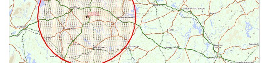
Ireland West Airport Knock Local Area Plan 2012-2018

           ii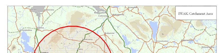
Ireland West Airport Knock Local Area Plan 2012-2018

Table of Contents

Section 1             Introduction .................................................................... 1
  1.1 Statutory Context...........................................................................................1
  1.2 Purpose of the Local Area Plan.....................................................................1
  1.3 Plan Area .......................................................................................................1
  1.4 Public Consultation.......................................................................................2
  1.5 Plan Format...................................................................................................3
  1.6 Environmental Assessments .........................................................................3
     1.6.1 Strategic Environmental Assessment (SEA).........................................3
     1.6.2 Appropriate Assessment (AA) ...............................................................3
     1.6.3 Flood Risk Assessment (FRA) ..............................................................4

Section 2             Strategic Planning Context and Considerations............. 5
  2.1 Policy Context ...............................................................................................5
  2.2 National and Regional Planning Context.....................................................5
     2.2.1 The National Development Plan 2007 – 2013 (NDP) ...........................5
     2.2.2 The National Spatial Strategy 2002 – 2020 (NSS) .................................5
     2.2.3 Regional Planning Guidelines for the West Region 2010-2022 .............7
     2.2.4 National Planning Guidelines ...............................................................7
  2.3 County Context .............................................................................................7
     2.3.1 Mayo County Development Plan 2008-2014 ..........................................7

Section 3             Profile of Ireland West Airport Knock ............................ 9
  3.1 Physical 9
  3.2 Historical.......................................................................................................9
  3.3 Ireland West Airport Knock Today ...............................................................9
  3.4 Population and Demographic Profile ......................................................... 10
  3.5 Transportation............................................................................................. 13
     3.5.1 Road Network...................................................................................... 13
     3.5.2 Public Transport.................................................................................. 14
  3.6 Infrastructure............................................................................................... 14
     3.6.1 Water Supply........................................................................................ 14
     3.6.2 Waste Water ......................................................................................... 14
     3.6.3 Surface Water....................................................................................... 15
     3.6.4 Electricity Supply................................................................................. 15
     3.6.5 Telecommunications ........................................................................... 15
     3.6.6 Gas ....................................................................................................... 15
  3.7 Airport Infrastructure .................................................................................. 15
     3.7.1 Runways............................................................................................... 15
     3.7.2 Taxiways .............................................................................................. 16
     3.7.3 Aircraft Apron Areas ............................................................................ 16
     3.7.4 Terminals and Piers............................................................................. 16
     3.7.5 Hangerage, Maintenance and Aviation Fuel Farm ............................ 16
     3.7.6 Car Parking.......................................................................................... 16
  3.8 Natural and Cultural Heritage .................................................................... 17
     3.8.1 Natural Heritage ................................................................................. 17
     3.8.2 Architectural Heritage......................................................................... 18

                                                          iii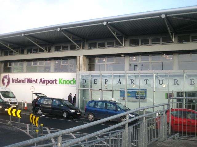
Ireland West Airport Knock Local Area Plan 2012-2018

     3.8.3 Archaeological Heritage...................................................................... 18
  3.9 Flooding ...................................................................................................... 19
  3.10 Landscape ...................................................................................................20

Section 4             Development Strategy for Ireland West Airport Knock .21
  4.1 Development Strategy ................................................................................. 21
  4.2 Land Use Zoning ........................................................................................ 21
     4.2.1 Zoning Methodology........................................................................... 21
     4.2.2 Land Use Zones and Objectives .........................................................22
  4.3 Airport Development Zone .........................................................................23
     4.3.1 Introduction.........................................................................................23
     4.3.2 Land Ownership, Co-operation and Profit Sharing ............................23
     4.3.3 Phasing ................................................................................................23

Section 5             Policies and Objectives ................................................. 25
  5.1 Introduction.................................................................................................25
  5.2 Strategic Development ................................................................................25
     5.2.1 Policies Strategic Development...........................................................25
     5.2.2 Objectives Strategic Development ......................................................25
  5.3 Land Use .....................................................................................................26
     5.3.1 Land Use Policies ................................................................................26
     5.3.2 Land Use Objectives ...........................................................................26
  5.4 Sustainability Options .................................................................................26
     5.4.1 Sustainability Policies..........................................................................26
     5.4.2 Sustainability Objectives .....................................................................26
  5.5 Transport .....................................................................................................27
     5.5.1 Transport Policies................................................................................27
     5.5.2 Transport Objectives ...........................................................................27
  5.6 Infrastructure Provision (Utilities)..............................................................28
     5.6.1 Policies Infrastructure Provision (Utilities) ........................................28
     5.6.2 Objectives Infrastructure Provision (Utilities)....................................28
  5.7 Airport Infrastructure and Operations ........................................................30
     5.7.1 Airport Infrastructure and Operation Policies ....................................30
     5.7.2 Airport Infrastructure and Operation Objectives................................30
  5.8 Heritage, Landscape and Environment......................................................30
     5.8.1 Heritage, Landscape and Environment Policies ................................ 31
     5.8.2 Heritage, Landscape and Environment Objectives............................ 31
  5.9 Economic Activities ....................................................................................32
     5.9.1 Economic Policies ...............................................................................33
     5.9.2 Economic Objectives ..........................................................................33

Section 6             Development Management Standards and Guidance .. 35
  6.1 Introduction.................................................................................................35
  6.2 Sequential Approach to Development Proposals .......................................35
  6.3 Environmental Management Report (EMR).............................................35
     6.3.1 Contents of the Environmental Management Report.........................35
     6.3.2 Ecological Assessment ........................................................................37
     6.3.3 Peat Management and Disposal Plan .................................................38
     6.3.4 Geotechnical Assessment ....................................................................38

                                                         iv
Ireland West Airport Knock Local Area Plan 2012-2018

     6.3.5 Surface Water Management Plan ........................................................39
     6.3.6 Air, Climate and Energy Factors.........................................................39
     6.3.7 Operational Waste Management Plan ................................................40
     6.3.8 Archaeological Assessment .................................................................40
  6.4 Site Layout and Building Design Guidelines ............................................. 41
     6.4.1 Objectives of the Design Guidelines................................................... 41
     6.4.2 Site Design...........................................................................................42
     6.4.3 Building Design...................................................................................43
  6.5 Public Lighting ...........................................................................................43
  6.6 Waste Water Treatment...............................................................................44
  6.7 Drinking Water............................................................................................44
  6.8 Surface Water Drainage...............................................................................44
  6.9 Road Access and Safety...............................................................................44
  6.10 Parking Requirements ................................................................................45
     6.10.1 Car Parking..........................................................................................45
     6.10.2 Bicycle Parking....................................................................................45
  6.11 Implementing the LAP – Making it Happen .............................................45

Land Use Zoning ................................................................................ 47
Public Safety Zones............................................................................. 53
Aerodrome Safeguarding relating to Obstacle Limitation Surfaces .... 61
Noise Contours ................................................................................... 67
Appendix 1           Phasing Methodology ................................................... 73
Appendix 2 Peat Management and Disposal Plan Guidance
                     Document...................................................................... 77
Appendix 3 Guidance Documents ................................................... 83

                                                        v
Ireland West Airport Knock Local Area Plan 2012-2018

List of Figures
Fig 1: Aerial view of Ireland West Airport Knock showing LAP Boundary      2
Fig 2: Ireland West Airport Knock in the context of the Western Region
        of the NSS                                                         6
Fig 3: Location of Ireland West Airport Knock                              9
Fig 4: Ireland West Airport Knock Catchment Area                           12
Fig 5: Road Network                                                        13
Fig 6: Map showing Record of Monuments and Places (RMP)                    19

List of Tables
Table 1
Population at State, County, and Catchment Areas between 2002 – 2006       11
Table 2
The declared distances of the runway                                       16
Table 3:
Designated Sites within a 5km radius of LAP study area                     17
Table 4
Record of Monuments and Places (RPM)                                       18
Table 5:
Phasing of Development                                                     24
Table 6:
Land Use Zones and Land Uses Generally Permitted                           48

List of Maps
Map 1        Land Use Zoning                                               51
Map 2        Public Safety Zones                                           57
Map 3        Public Safety Zones & Land Use Zoning                         59
Map 4        Safe Guarding                                                 63
Map 4a       Safe Guarding within LAP Boundary                             65
Map 5        Noise Contours                                                69
Map 6        Noise Contours & Land Use Zoning                              71

                                       vi
Ireland West Airport Knock Local Area Plan 2012-2018

Section 1      Introduction
1.1     Statutory Context
This Local Area Plan (LAP) has been prepared in accordance with Sections 18 – 20 of
the Planning and Development Acts 2000 – 2010. It is the first statutory land use plan
that has been made for Ireland West Airport Knock. This plan shall remain in force for
a period of 6 years from the date of adoption by Mayo County Council unless it is
amended or revoked before this period.

A Local Area Plan is required to be consistent with the policies and objectives of the
County Development Plan. Accordingly, this LAP should be read in conjunction with
the Mayo County Development Plan 2008 – 2014 which sets out the overall
development strategy for the county, including a core strategy. Where any provision of
the LAP conflicts with the provisions of the County Development Plan (as varied or a
new CDP) the provision of the LAP shall cease to have effect.

1.2      Purpose of the Local Area Plan
Ireland West Airport Knock was officially opened in 1986 as Ireland’s fourth
international airport. Mayo County Council recognises that Ireland West Airport Knock
has the potential to be a key economic driver for the West Region. To support and
promote this role objective O/TI-A1 of the Mayo County Development Plan 2008-2014
states that ‘It is an objective of the Council to request the Minister of the Environment,
Heritage and Local Government to designate the area around Ireland West Airport
Knock as a Strategic Development Zone’

In 2008 Mayo County Council, pursuant to the Planning and Development Act 2000 –
2010, applied to the Minister (DoEHLG), to designate the lands in the vicinity of Ireland
West Airport Knock as a Strategic Development Zone (SDZ). In response, the
DoEHLG suggested adopting a best practice approach similar to other SDZ
designations by first preparing a Local Area Plan. It is intended that the Local Area Plan
will identify any development issues that may require to be addressed before proceeding
with the SDZ designation proposal.

The Ireland West Airport Knock LAP provides a policy framework to guide and manage
the future growth and sustainable development of Ireland West Airport Knock over the
next 6 years. It sets out objectives for the zoning of land for particular uses within and
adjacent to the airport and provides the framework against which planning applications
will be assessed. The overall strategy of the LAP is consistent with national, regional and
county policy and guidance, including the Council’s objective that the area should be
designated as a SDZ. In addition, the aspirations and views of the local community as
put forward during the public consultation phase of the plan preparation process have
been taken into consideration. Although, the statutory period of the LAP is six years, the
development strategy set out in this plan will shape the future growth and development
of Ireland West Airport Knock beyond the plan period including the timeframe of the
proposed SDZ designation.

1.3    Plan Area
The LAP refers to the lands located around Ireland West Airport Knock including all
lands within the airport campus (See Fig. 1). The total LAP area extends to
approximately 355 Ha (878 Acres). The LAP boundary was drawn up following
consideration of the following:

                                            1
Ireland West Airport Knock Local Area Plan 2012-2018
topography of the area and the potential impact on the landscape
current infrastructure capacities
existing land constraints, such as housing and active quarry activity in the vicinity
of Ireland West Airport Knock
the future airside infrastructure requirements of Ireland West Airport Knock
Regional Planning Guidelines for the West Region 2010-2022 and the Mayo
County Development Plan 2008-2014
the need for sufficient floor space to create critical mass as a regional / sub-
regional development centre
the commercial development potential of the lands in the vicinity of Ireland West
Airport Knock based on economic forecasts
the commitment of landowners in the vicinity of Ireland West Airport Knock
the need to facilitate Ireland West Airport Knocks’ potential to become a key
economic driver for the region
environmental considerations resulting from the Strategic Environmental
Assessment, Appropriate Assessment and Flood Risk Assessment processes.
Fig 1: Aerial view of Ireland West Airport Knock showing LAP Boundary
1.4 Public Consultation
The Planning and Development Acts 2000 – 2010 requires the planning authority to take
whatever steps it considers necessary to consult the public before preparing a Local Area
Plan.
Prior to preparing the LAP, the Council held a “Pre-Draft Public Consultation Open
Day” in Charlestown on the 29/9/2010. The public were invited to attend the open day
to discuss the process involved in the preparation of the Local Area Plan and make their
views known. Written submissions from the public were also invited as part of the pre-
2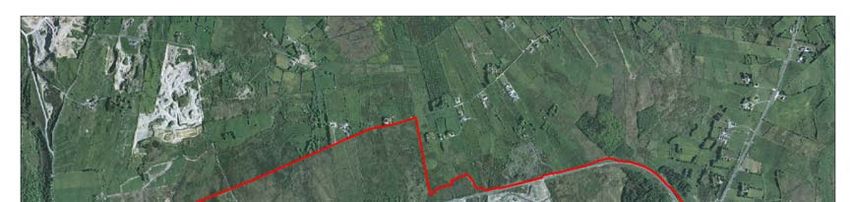
Ireland West Airport Knock Local Area Plan 2012-2018
draft consultation process. Issues raised during the pre-draft consultation phase related
to:
deficiencies in the public water supply to the area
concerns about surface water run-off from the runway onto public roads
concerns relating to increase in traffic movements to the area
supporting the need to further develop the airport.
This process was integral in shaping the strategy, aims and objectives of the Plan.
Accordingly, it should not be viewed merely as a regulatory document, but rather as an
expression of the Council’s vision, in partnership with the wider public, for the
sustainable development of Ireland West Airport Knock over the next 6 years and the
steps we need to take to achieve this vision.
1.5 Plan Format
This Plan consists of a single document made up of a written statement and associated
maps.
Section 1 Introduction to the LAP
Section 2 Sets out the strategic planning context for the Ireland West Airport Knock
LAP
Section 3 Survey and Analysis of the Area
Section 4 Sets out the development strategy for the Ireland West Airport Knock LAP
Section 5 Sets out the policies and objectives of the Ireland West Airport Knock LAP
Section 6 Sets out the development management standards and guidelines
1.6 Environmental Assessments
1.6.1 Strategic Environmental Assessment (SEA)
SEA is a formal, systematic evaluation of the likely environmental effects of
implementing a proposed plan, or other strategic action, in order to ensure that these
effects are appropriately addressed at the earliest appropriate stage of decision making
and on a par with economic and social considerations.
Due to the nature and scale of the LAP, the implementation of which would have a
considerable impact on a large area of undeveloped lands, Mayo County Council carried
out a full Strategic Environmental Assessment of the LAP. The SEA process has
informed the policies and objectives of the LAP. The Environmental Report on the
SEA of the Ireland West Airport Knock LAP accompanies this plan.
1.6.2 Appropriate Assessment (AA)
Natura 2000 sites are those identified as sites of Community Importance under the
Habitats Directive (Special Areas of Conservation SAC) or classified as Special
Protection Areas (SPA) under the Birds Directive 79/409/EEC. Local Area Plans shall
also comply with the provisions of Article 6(3) and (4) of the Habitats Directive
92/43/EEC, which requires an Appropriate Assessment of any Plan or Project, whether
it is within or outside a designated ‘Natura 2000’ site, which may impact upon the
conservation objectives of that site.
There are no Natura 2000 sites located within or adjacent to the LAP area. However
there are a number of Natura 2000 sites within 15km of the Plan boundary, most notably
the River Moy Complex SAC. As there are a number of minor tributaries and streams
within and adjoining the LAP boundary that feed into this SAC a full Appropriate
3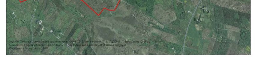
Ireland West Airport Knock Local Area Plan 2012-2018

Assessment was carried out to determine the environmental impact that implementation
of the LAP would have on the Natura 2000 sites. The Appropriate Assessment of the
Ireland West Airport Knock LAP accompanies this plan.

1.6.3 Flood Risk Assessment (FRA)
‘The Planning System and Flood Risk Management Guidelines 2009’ were issued by the
Minister of the Environment, Heritage and Local Government under Section 28 of the
Planning and Development Act 2000, as amended. Planning Authorities and An Bord
Pleanala are required to have regard to the Guidelines in carrying out their functions
under the Planning Acts. The Guidelines introduce comprehensive mechanisms, such as
Strategic Flood Risk Assessment (SFRA), for the incorporation of flood risk
identification, assessment and management into the planning process. Implementation
of the Guidelines is achieved through actions at national, regional, local and site specific
levels.

A Strategic Flood Risk Assessment was carried out on the Ireland West Airport Knock
LAP. It provided an appraisal and assessment of available flood risk data for the land
use proposals within the boundary of the Ireland West Airport Knock LAP. The process
identified flood risk indicators in each area and where it was demonstrated that lands may
be at risk of flooding, modifications were recommended to land-use proposals or the
carrying out of a more detailed flood risk assessment as appropriate was recommended.

                                             4
Ireland West Airport Knock Local Area Plan 2012-2018
Section 2 Strategic Planning Context and Considerations
2.1 Policy Context
The Ireland West Airport Knock Local Area Plan is required to be consistent with the
policies and practices of a hierarchy of Plans and Guidelines which set out the strategic
context for the overall strategy as set out in the LAP. Relevant documents within this
hierarchy (but not limited to) include:
The National Development Plan 2007 – 2013
The National Spatial Strategy 2002 – 2020
The Regional Planning Guidelines for the West Region 2010 – 2022
The Mayo County Development Plan 2008 – 2014
The Mayo County Retail Strategy 2008
The Mayo County Housing Strategy 2008
The Mayo County Development Board 10 Year Integrated Strategy
Various Guidelines for Planning Authorities
While at the lower end of this hierarchy the LAP has been informed by the policy
documents and guidelines listed above so as to ensure proper planning and sustainable
development. Various issues were also identified during the pre-draft public consultation
phase were also been taken into consideration in preparing this LAP.
2.2 National and Regional Planning Context
2.2.1 The National Development Plan 2007 – 2013 (NDP)
The National Development Plan 2007 – 2013 sets out Irelands future as an enlarged
urbanised society within a defined urban hierarchy. The NDP aims to promote balanced
regional development, social inclusion and enhanced economic competiveness. The
NDP provides general policies for infrastructure development for all regions of Ireland.
The NDP acknowledges the role of regional airports:
“Regional airports play an important role in improving access to more remote areas of
the Country particularly for business and tourist interests. Within the BMW Region, the
contribution of the four regional airports (Donegal, Galway, Knock and Sligo) to
improving tourism and business access to the Region can be enhanced by upgrading of
the existing infrastructure”.
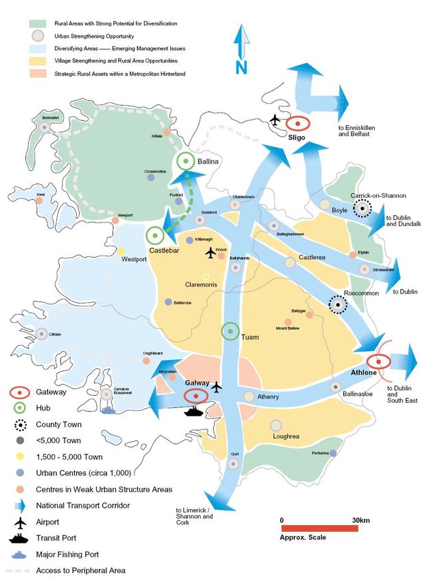
2.2.2 The National Spatial Strategy 2002 – 2020 (NSS)
The National Spatial Strategy outlines an overall national approach to spatial planning.
Its aim is to facilitate balanced regional development throughout the Country. In Mayo,
the NSS identifies the towns of Ballina and Castlebar as a linked hub, the aim of which is
to complement the nearby gateways of Galway and Sligo, whilst also providing services
to its associated catchments.
The NSS highlights Ireland West Airport Knock in an International Spatial Context with
links to International Air Hubs (London) while reinforcing its importance within the
Regional context with links to Dublin. The NSS confirms the importance of Ireland
West Airport Knock due to its proximity to the hub towns of Castlebar, Ballina and
Tuam and its central location between the Gateways of Sligo and Galway.
5Ireland West Airport Knock Local Area Plan 2012-2018
“Castlebar, Ballina and Tuam, as hubs, will perform important roles within the National
structure at the regional and county level. Critical factors will include improvements in
regional accessibility through advanced communications, infrastructure, by road and
public transport and through the regional airport at Knock”
The NSS highlights that appropriate infrastructure may need to be provided ahead of
actual need in order to readdress existing imbalances of development between the East
and West of the Country and states that
“Knock airport should be developed as an industrial hub for East Mayo”
Fig 2: Ireland West Airport Knock in the context of the Western Region of the NSS
Source: National Spatial Strategy 2002 -2020
6Ireland West Airport Knock Local Area Plan 2012-2018
2.2.3 Regional Planning Guidelines for the West Region 2010-2022
The Regional Planning Guidelines (RPG’s) for the West Region 2010 – 2022 set out a
framework for the long term strategic development of counties Mayo, Galway and
Roscommon. The RPG’s aim is to deliver balanced regional development with specific
objectives to stimulate social, economic and cultural development.
The RPG’s outline a strategic role for Ireland West Airport Knock:
“The strategic importance of Ireland West Airport Knock as an amenity and an
important transportation link to facilitate the growth and connectivity to the West
Region”
“To develop hubs for industry and commerce adjacent to or in the region around the
airport”
“To support the designation of a Strategic Development Zone at Ireland West Airport
Knock”
“To facilitate the appropriate and sustainable development of industrial/commercial
lands and structures adjacent or close to the airport.”
2.2.4 National Planning Guidelines
There are a number of National Planning Guidelines that have guided the strategy and
objectives set out in this Local Area Plan. These include, but are not limited to, the
following:
Implementing Regional Planning Guidelines - best practice guidelines (2005)
Landscape and Landscape Assessment (2000)
Development Plans Guidelines (2007)
Retail Planning Guidelines (2005)
Implementation of Strategic Environmental Assessment Directive: Assessment
of the Effects of Certain Plans and Programmes on the Environment. (2004)
Appropriate assessment of Plans and Projects in Ireland: Guidance for Planning
Authorities (2009)
The Planning System and Flood Risk Management - Guidelines for Local
Authorities (2009)
The National Climate Change Strategy 2007-2012
Smarter Travel: A Sustainable Transport Future
2.3 County Context
2.3.1 Mayo County Development Plan 2008-2014
The Mayo County Development Plan was adopted in 2008 and sets out a policy
framework for development within the county until 2014. The Plan sets out a long term
vision for the development of the County through the principles of sustainable
development and social partnership. The Plan was varied in 2011 to incorporate a Core
Strategy, the purpose of which is to set out an evidence based strategy for spatial
development of the county and to demonstrate that the development objectives in the
development plan are consistent, as far a practicable, with national and regional
development objectives set out in the NSS and RPGs. A central component of the Core
Strategy is the County Settlement Strategy which based on a settlement hierarchy, which
itself, is consistent with the spatial structure, aims and objectives of the NSS and RPGs.
The Ireland West Airport Knock LAP sets out a plan-led framework to facilitate the
development of Ireland West Airport Knock as an economic driver in the County and
7Ireland West Airport Knock Local Area Plan 2012-2018
supports the aims, policies and objective of the Mayo County Development Plan 2008-
2014.
The County Development Plan specifically identifies the future growth of Ireland West
Airport Knock through the following aims, polices and objectives.
Development Aims Policies /Objectives
Transportation and Infrastructure Policies
to support and promote the P/TI-A 1 It is the policy of the Council to support the
development of the transportation development of Ireland West Airport Knock in accordance
assets of the County, including with the principles of proper planning and sustainable
Ireland West International Airport development.
Knock, and the strategic road and rail
corridors as critical elements of the Objectives
intra/inter regional linkages. O/TI-A 1 It is an objective of the Council to request the
Minister of the Environment, Heritage and Local
County Development Strategy Government to designate the area around Ireland West
the sub-regional role of Ballina / Airport Knock as a Strategic Development Zone.
Castlebar as a linked hub
development hub and Westport as its O/TI-A 2 It is an objective of the Council to prepare a
natural extension necessitate the Public Safety Zone Map for Ireland West Airport Knock
provision of appropriate levels of
physical and social infrastructure O/TI-A 3 It is an objective of the council to create and
including: enforce an exclusionary zone of a 13km radius of Ireland
public transport connections West Airport Knock. The 13km exclusionary zone shall
between the hub towns, define a volume of airspace, by means of Obstacle Limitation
Westport and Ireland West Surfaces, above which no new objects shall be permitted.
Airport Knock The 13km exclusionary zone shall define an area within
which no new conventional or residual landfills shall be
constructed.
improvement and development
of Ireland West Airport Knock
O/TI-RL 1 It is an objective of the Council to actively seek
and support the reinstatement of the Western Rail Corridor
and associated railway stations, including the section from
Claremorris to Collooney, as a strategic transport corridor
linking Mayo with Sligo, Galway and Limerick, emphasising
the potential link to Ireland West International Airport from
Swinford, Kiltimagh, Charlestown or whichever route is
deemed the most suitable for such a link.
Other policy documents at the County level which have informed the LAP include:
Mayo County Housing Strategy Mayo County Retail Strategy 2008
2008
The Ireland West Airport Knock LAP will The Retail Strategy outlines retail policies for the County which
not impact on the provision of housing includes strengthening the role of the linked hub towns of
supply in the County as it is not proposed Castlebar and Ballina through the support of the Second Tier
to provide for residential uses in the LAP Towns indentified in the County Development Plan. The future
area. The policies and objectives of the development of Ireland West Airport Knock is key to the future
Mayo County Development Plan will development of Mayo in terms of the strategic importance of the
continue to apply to lands outside of the Airport as an amenity and important transportation hub to
LAP boundary. facilitate the growth and connectivity to the West Region.
Therefore the implementation of the Ireland West Airport
Knock LAP indirectly supports the overall objectives of the
Retail Strategy.
Mayo County Development Board 10-year Integrated Strategy
“Maigh Eo Le Cheile le Neart – Mayo County Development Board 10-year Integrated Strategy” sets out a ten
year strategy for economic, social and cultural development of the County. The Strategy highlights the
importance of Ireland West International Airport and stresses the need for “the further development of Knock
Airport, including the development of land for industrial purposes”
8Ireland West Airport Knock Local Area Plan 2012-2018
Section 3 Profile of Ireland West Airport Knock
3.1 Physical
Ireland West Airport Knock is located in the townland of Kilgarriff West and is centrally
located in the Region along the National Primary Route (N17 Galway / Sligo) and 7 km
from the National Primary Road (N5) which links Mayo to Dublin. Its location is pivotal
in the Regional context as it is 50km from the linked Hub of Ballina/Castlebar, 55 km
from the Gateway of Sligo and 90km from the Gateway of Galway.
Fig 3: Location of Ireland West Airport Knock
3.2 Historical
The construction of Ireland West Airport Knock was instigated by Monsignor James
Horan, who envisioned the airport as a link to Rome, the Vatican and other religious
destinations. The airport enjoyed modest success during its early years of operation. By
1989 total annual air passenger movements had reached 145,000. Passenger throughput
remained at this level through 1990 but then fell by 30 percent to 101,000 in 1991.
Passenger numbers increased steadily following the introduction of Ryanair’s scheduled
service to London Stansted in 1992 and by 1999 annual passenger throughput had
reached 207,000. Following another period of instability between 1999 and 2002, air
passenger movements began to rise rapidly following the introduction of low fares
services to Birmingham in March 2003 and to Manchester in March 2004. The airport
handled a total of 373,000 annual air passenger movements in 2004. (Source: Ireland
West Airport Knock cumulative EIS, 2010) In 2011, the airport celebrated its 4
millionth passenger
3.3 Ireland West Airport Knock Today
The total national contributions of all activities at Ireland West Airport Knock in 2010
from expenditure form goods and services were €17.0m and 167 full time equivalent
(FTE) jobs. The total contributions due to tourist generated activities in 2010 were
9Ireland West Airport Knock Local Area Plan 2012-2018
€111m and 817 FTE jobs. (Source: Ireland West Airport Knock – Economic Study,
Ernst and Young, 2011)
In 2009 a new 3000m2 terminal building was opened at the airport. This included a new
improved departure area for passengers. The airport has also installed and implemented
a new Instrument Landing System thus reducing by 98% the possibility of aircraft
diversion to other airports. In improving its customer service Ireland West Airport
Knock has developed new real time flight arrival and departure information which
provides up-to-date travel information both at the terminal and online.
There are a number of Industrial / Warehousing units adjoining the airport site which
provide services and additional employment to the area. Planning permission currently
exists on site for the further expansion of this Industrial / Warehousing area.
3.4 Population and Demographic Profile
Receiving Environment
The airport acts as an International Gateway to the West of Ireland, North-West and
Midlands. In this context is well positioned within the region to serve a catchment area
of close to 1 million people, with large urban areas such as Galway, Athlone and Sligo,
located within a two hour commuting distance from the airport.
Demographic Profile
In order to analyse the demographic profile of the area for the airport, all of the urban
areas with a 25 km radius were examined. These include; Charlestown, Swinford, Knock,
Kiltimagh, Ballyhaunis, Tubercurry, Ballaghdereen, Castlerea and Claremorris. These
towns only represent part of the receiving population as there is a significant rural area
within the catchment. However, it is considered that using the data for the towns only
would give an overall trend to the demographic profile of the area surrounding the
airport.
The airport also draws on the linked hub towns of Castlebar and Ballina and the
regionally important towns of Boyle, Strokestown, Roscommon and Carrick on Shannon.
In this context all of the towns in the area surrounding the airport and wider area form
part of the policy growth areas outlined in the National Spatial Strategy, Regional
Planning Guidelines and County Development Plans.
Population Change
The population of Ireland in 2011 was 4,588,252 persons compared with 4,239,848
persons in 2006, which represents an increase of 8.4%. The population of Mayo in 2011
was 130,638 persons, compared with 123,839 persons in 2006. Despite the population
growth recorded in the County between 2011 and 2006, Mayo’s share of the West
Region population continued to decline - from 30% in 2006 to 29% in 2011. The
Regional Planning Guidelines for the West 2010-2022 set out population targets for
Mayo of 143,640 for 2016, which would be 30% share of the projected West Regions
population, and 150,800 in 2022, which would be 29% share of the projected West
Regions population.
The population changes are illustrated in Table 1
10Ireland West Airport Knock Local Area Plan 2012-2018
Table 1: Population at State, County, and Catchment Areas between 2002 – 2006 - 2011
Area Total Population % Change Population %Change
2002 2006 2011
State 3,917,203 4,239,848 +8% 4,588,252 +8.2%
Mayo 117,446 123,839 +5% 130,638 +5.5%
Urban Areas with 25k 20,862 22,966 +9% 24,895 +8.4%
Regionally Important 28,730 30,695 +6% 36,136 +17.7%
Towns
Source: Census of Population 2002, 2006, and 2011
11Ireland West Airport Knock Local Area Plan 2012-2018
Fig 4: Ireland West Airport Knock Catchment Area
12Ireland West Airport Knock Local Area Plan 2012-2018
3.5 Transportation
3.5.1 Road Network
Access to the LAP area from the National Primary Route (N17) is via the R376 Regional
Road. The N17 links the Gateways of Galway and Sligo and intersects with the National
Primary Route N5 Dublin to Westport approximately 7km to the north of the Airport.
Fig 5: Road Network
Traffic counts at the junction of the N17 and the R376 in 2008 recorded 3558 Annual
Average Daily Traffic Counts (AADT), with the N17 recording 6769 AADT. The National
Roads Authority has plans to re-align the N17, bypassing
Charlestown and a number of route options are currently Emerging Issues:
being considered which will result in improved access to the need to ensure that access is
via the N17
area. local road network may not
have adequate capacity for
The R376 Regional Road traverses the centre of the LAP any increased traffic
area. To the North of the Regional Road are undeveloped movements
lands, whilst the lands to the South contain the Airport reduce dependency on the
Campus. The Airport is accessed off the R376 by a car to access the LAP area
roundabout with a spur leading to the Airport. Passenger
circulation is through the existing car park. The situation is not ideal as the drop off and
pick up areas are not separate from the airport parking area. The provision of a new access
to the airport separating the car parking area from the drop off and pick up points would
create a more effective circulation space for both vehicular and pedestrian movements
within Airport Campus.
13Ireland West Airport Knock Local Area Plan 2012-2018
3.5.2 Public Transport
The Dublin to Westport/Ballina train service, currently operates four daily services in either
direction, and is the only active train service operating within Mayo. The nearest train
station is at Claremorris, which is approximately 30km to the south on the N17. The
proposal to re-open the Western Rail Corridor between Sligo and Limerick would offer
opportunities to provide a rail access to the airport. It would also provide the towns of
Kiltimagh, Swinford and Charlestown, all within a short transfer distance to the airport,
access to the national rail network. The re-opening of the Western Rail Corridor offers the
possibility of providing a rail link from the LAP area to one of the above towns. In this
context the provision of a rail terminal within the LAP area could be examined as a viable
option.
Bus Eireann provides a daily service to Ireland West Airport Knock. Route 64 (Galway-
Sligo) provides seven services a day from both Galway and Sligo to the Airport.
3.6 Infrastructure
3.6.1 Water Supply
The current water supply is sourced from a well, which is in the ownership of Mayo County
Council. Tests on the supply indicate that the safe yield from the supply is 350m3/day. The
current usage from this supply is from two sources, the Airport (50m3/day) and the
Cloonlyan Group Water Scheme (14m3/day). In terms of water supply for the LAP Area,
this is not a sustainable option as this source will only facilitate development in the short
term. In the intermediate term upgrading the Kilkelly Water Emerging Issues:
Supply to provide a link to the area would yield an additional a more secure sustainable
300m3/day of water. The long term aim is to provide a link to supply of water needs to be
the East Mayo Regional Water Supply Scheme which would sourced for the LAP area.
guarantee a sufficient supply of water. existing treatment plant can
be upgraded to double the
capacity
3.6.2 Waste Water a new waste water treatment
The existing Waste Water Treatment Plant was commissioned facility would be required
in 2004 with a design Population Equivalent (PE) of 700. for the area to develop to its
Taking the current usage into consideration, the treatment plant full potential
has a spare capacity for PE of 370. The treatment plant uses a surface water management
system required for the LAP
Sequencing Batch Reactor design which utilises the activated area
sludge process to treat the incoming waste water. The final
effluent is discharged through a 100mm rising main outfall pipe (length 2,750m) to the
Sonnagh River in the townland of Killeen. The Sonnagh is a tributary of the River Moy
which is designated as a Special Area of Conservation (SAC) (Site Code 000298)
The existing treatment plant can easily be expanded to double the capacity to cater for a PE
of 1400. Any further expansion would require the construction of a completely new Waste
Water Treatment Plant. To enable the LAP area to develop to its full potential it is expected
that a Waste Water Treatment Plant capable of accommodating a population equivalent of at
least a 5000 PE is required.
14Ireland West Airport Knock Local Area Plan 2012-2018
3.6.3 Surface Water
At present there is no public surface water drainage system within the LAP area. Surface
water is currently disposed off to existing drains and watercourses throughout the LAP area.
3.6.4 Electricity Supply
The airport is supplied by 10 kV line from the Charlestown 38kV/MV station via an outlet
located at Charlestown (Airport Outlet). Standby provisions from this outlet are located at
Swinford and Tubercurry. The supply feeds to a 600 kVA substation located on the airport
property which supplies the airport and adjoining industrial park with power.
ESB Networks have a number of projects lined up to improve Emerging Issues:
the supply of electricity to the area. These include: dependency on electricity
supply.
refurbishment of the Charlestown 38kV station. This no other sources of energy
will improve station operations and facilitate the supply supply to the LAP area
needs of new and growing loads, while maintaining
existing supplies.
the Charlestown outlet which feed the Airport will be split into two separate outlets.
Splitting the outlet will mean that the Airport and other customers within the area
will have a more dedicated supply which will improve the overall security of supply.
a new standby facility is proposed for the Airport by converting a section of single
phase network to three phase. This will ensure that if there is a line fault, the area
will have a supply.
3.6.5 Telecommunications
Mayo County Council has provided a Metropolitan Area Networks (MANs) around the
airport site offering a fast and efficient telecommunications network within the LAP area.
MANs is a high capacity fibre optic system which is future proofed and offers virtually
limitless capacity in terms of broadband and other telecommunication systems.
3.6.6 Gas
The Mayo-Galway Gas Pipeline runs to the West of Claremorris, with a spur feeding
Claremorris. Extending this spur to the LAP area would be beneficial to attracting
development.
3.7 Airport Infrastructure
3.7.1 Runways
The existing runway (27-09 runway) is 2300 metres long and 45 metres wide. The runway
has turning circles, 80 metres in diameter at each end, symmetrical about the runway
centreline. The runway strip is a defined area which includes the runway and stopway and is
intended to reduce the risk of damage to aircraft running off a runway and to protect aircraft
during take off and landing operations.
15Ireland West Airport Knock Local Area Plan 2012-2018
Table 2: The declared distances of the runway:
TORA ASDA TODA LDA
(Take Off Run (Accelerate Stop (Take Off Distance (Landing Distance
Available) distance Available) Available) Available)
(m) (m) (m) (m)
Runway 27 2270 2300 2300 2270
Runway 9 2240 2300 2300 2087
The current runway strip is 300 metres wide and is in compliance with the International Civil
Aviation Organisations (ICAO) recommendations for CAT 2 runways. No fixed objects
except for visual aids required for navigation purposes as set out by the ICAO are permitted
within the runway strip. The existing runway is sufficient to cater for planned and future
aircraft requirements, but it may be necessary to consider an extension of the runway to cater
for a wider range of aircraft.
3.7.2 Taxiways
The airport has a 23m wide taxiway connecting the runway to the passenger apron. Access
to the freight apron from the runway is provided by a second taxiway 23m in width. The
development of a taxiway parallel to the existing runway would
allow landing passenger and freight aircraft to clear the runway Emerging Issues:
ensure lands about the
without affecting runway operations. airport campus are
safeguarded to allow for the
3.7.3 Aircraft Apron Areas future expansion of all
The current passenger apron has sufficient capacity for three airport infrastructure
aircraft, giving easy access to and from the terminal building. The provision.
freight apron is located towards the Western boundary of the
airport, which, if necessary, can also be used as an overflow facility for passenger handling.
Any future development of the airport would require the extension of the apron area
possibly around a central pier.
3.7.4 Terminals and Piers
The original passenger terminal was built in 1986 and is located north of the runway directly
west of the current passenger apron. A 3000m2 extension to the terminal building was
opened in 2009 which has resulted in creating more circulation space for passengers, new
security screening areas, extended check in facilities, an increased departure lounge space as
well as new retail, catering and other facilities.
3.7.5 Hangerage, Maintenance and Aviation Fuel Farm
At present there are no maintenance or hangerage facilities. Any future development of the
airport would require the provision of maintenance facilities consisting of an apron area and
aircraft hanger. All of these elements would be located in a hangerage area which would
accommodate an aircraft maintenance area and aircraft reclamation/dismantling facilities. In
addition the fuel farm at the airport would need to expand its supply capacity.
3.7.6 Car Parking
The airport car park has capacity for 1600 cars. The expansion of the airport will necessitate
an increase in car parking capacity. Upgrading car parking facilities at the airport and
16Ireland West Airport Knock Local Area Plan 2012-2018
providing short term and long term parking will improve the movement and free flow of
traffic throughout the LAP area.
3.8 Natural and Cultural Heritage
3.8.1 Natural Heritage
The main habitats within the plan area, have been identified and described as part of the
Ireland West Airport Knock Cumulative EIS (prepared by the Airport Development
Company) and classified according to Fossitt (2000). They include cutover bog (PB4), wet
grassland (GS4), wet heath (HH3), dry humid acid grassland (GS3) and improved
agricultural grassland (GA1). Also present are eroding upland rivers (FW1), dry siliceous
heath (HH1), exposed siliceous rock and buildings (BL3). Currently, a relatively small
proportion of the SEA study area is taken up by the existing airfield, airport terminal
buildings and associated landside facilities
There are no designated sites within the proposed Ireland West Airport Knock LAP area.
However, the River Moy cSAC is located approximately 2km to the north and south of the
study area. Two proposed NHAs are located within 4km of the plan area, namely Killaturly
Turlough pNHA and Lough Gower pNHA.
Table 3: Designated Sites (candidate Special Areas of Conservation (cSAC) and proposed National
Heritage Areas (pNHA)) within a 5km radius the Ireland West Airport Knock LAP study area
Designation Site Code Site Name
cSAC 002298 Moy Complex
pNHA 000511 Killaturly Turlough
pNHA 000523 Lough Gower
River Moy candidate Special Area of Conservation: Site Code cSAC 002298
The River Moy SAC is located approximately 4.5km to the northwest, northeast and
southwest of the LAP area. It comprises almost the entire freshwater element of the Moy
and its tributaries, including both Loughs Conn and Cullin. The system drains a catchment
area of 805 sq km. The site is a cSAC selected for alluvial wet woodlands and raised bog,
both priority habitats on Annex 1 of the EU Habitats Directive. The site is also selected for
old oak woodlands, degraded raised bog and Rhynchosporion, all habitats listed on Annex I
of the Habitats Directive. The site is also selected for the following species, listed on Annex
II of the Habitats Directive – Atlantic salmon, otter, Sea and Brook Lamprey and White-
clawed crayfish. Within the site are a number of raised bogs, including those at Kilgarriff,
Gowlaun, Derrynabrock, Tawnaghbeg and Cloongoonagh. The Moy system is one of
Ireland’s premier waters and it also encompasses two of Ireland’s best lake trout fisheries in
Loughs Conn and Cullin. In addition, the site also supports many more of the mammal
species occurring in Ireland. Those which are listed in the Irish Red Data Book include Pine
Marten, Badger, Irish Hare, Common Frog and Daubenton’s Bat.
Killaturley Turlough Natural Heritage Area: Site Code NHA 000511
Killaturley Turlough, located 4.9km to the northwest of the LAP area, is a permanent lake
set in a hollow between moraines and surrounded by bog. The main water source for the
basin seems to be a swallow hole at the eastern end and a stream which flows from the
southeast. Where peat has been largely removed, there are reeds (Phragmites australis) and
17Ireland West Airport Knock Local Area Plan 2012-2018
sedges (Carex diandra and C. serolina). Towards the southwest, this community merges into a
denser reedbed (Phragmites australis and Typha latifolia), which is surrounded by rushy fields
and patches of peat moss (Sphagnum spp). Snipe and water rail nest in the area, while other
water fowl are often present. Despite the small area of strictly Turlough vegetation, the site is
of value as a composite wetland and therefore warrants NHA status.
Lough Gower Natural Heritage Area: Site Code NHA 000523
Lough Gower NHA is located 4.1km to the southeast of the LAP area is small lake in the
catchment of the Boyle River. The surrounding land is mostly flat or gently undulating bog
or improved pasture. The lake bottom is sandy and colonised by aquatic mosses
(Drepanocladus spp.). The lakewater is a brownish colour, stained by peat and mineral
substances, and shows no sign of eutrophication. At its western end, the open water is
colonized by swamp vegetation. Floating Bur-Reed (Sparganium angustifolium) is of note in that
it is not commonly found in low-lying areas such as this. The northern lakeshore is bordered
by sloping grassland, which is partially colonized by Gorse (Ulex europaeus). Grassland species
include Yorkshire fog (Holcus lanatus) and Sweet vernal grass (Anthoxanthum odoratum).
Towards the top of the slope this grades into wet heath, with abundant sphagnum mosses
and Ling heather (Calluna vulgaris). South of the lake are fields, which have been heavily
improved for agricultural use. Perennial rye grass (Lolium perenne) is abundant in these
grasslands. Lough Gower is of importance as a lake of low nutrient status, which shows no
sign of eutrophication. Such lakes are uncommon in low-lying agricultural areas such as this.
In addition, it is fringed by semi-natural reed bed/swamp vegetation.
Along with sites designated for nature conservation, Mayo has many other areas of local
ecological importance including broadleaved woodlands, scrub, hedgerows, tree lines,
cutover bog and wet grassland. Many of these areas are important, helping to form wildlife
corridors and ecological networks across the landscape. These corridors and networks allow
animal species to move freely from one habitat to another.
3.8.2 Architectural Heritage
There is very little in terms of built heritage within the Ireland West Airport Knock LAP
area. Developments at the airport and a number of
unoccupied/derelict houses within the LAP area are not Emerging Issues:
considered architecturally important. No structure within the ensure sufficient measures
for the protection of the
Plan area is listed on the Record of Protected Structures. natural and built heritage
3.8.3 Archaeological Heritage
There are 12 items included on the Record of Monuments and Places (RMP) within or
adjoining the Ireland West Airport Knock LAP boundary. These are listed in Table 4 below:
Table4 Record of Monuments and Places (RPM)
RPM No. Monument Type
MA072-030 Enclosure and Souterrain
MA072-031 Enclosure
MA072-032 Enclosure- Site
MA072-033 Enclosure and Children’s Burial Ground
MA072-034 Enclosure
MA072-085 Wedge Tomb
MA072-117 Fulacht Fiadh
18Ireland West Airport Knock Local Area Plan 2012-2018
MA072-118 Ecclesiastical Remains-Possible
Graveyard-Possible
Children’s Burial Ground-Possible
House Site
MA072-119 Megalithic Tomb
MA072-120 Fulacht Fiadh
MA073-002 Enclosure and Children’s Burial Ground
MA073-034 Mound
Figure 6 below shows the location of items listed in Table 4.
Fig 6: Map showing Record of Monuments and Places (RMP)
3.9 Flooding
The main flood risk within the LAP area is Pluvial. Pluvial flooding can be defined as
flooding which results from rainfall generated overland flow and / or ponding which may
occur during or immediately after intense rainfall events, before the runoff enters any water
course or sewer.
Emerging Issues:
The Public consultation process also identified three areas need for a surface water
where flooding occurred that are not recorded on any OPW management system for the
Ireland West Airport Knock
mapping or flood related database. The first is to the north of LAP area
the LAP boundary where a local road floods, during heavy
rainfall causing a drain to overflow before it discharges to a
nearby stream. The second location is to the West of the Runway where ponding occurs,
again just after heavy rainfall. The third relates to lands across from the N17 which floods,
again after heavy rain.
19Ireland West Airport Knock Local Area Plan 2012-2018
3.10 Landscape
The location of the existing Airport campus is on elevated Emerging Issues:
lands adjoining the N17 approximately 8km South of ensure that all proposed
Charlestown. The existing airport facilities and adjoining developments are absorbed
business park are located on an upper plateau that gently into the surrounding
slopes to the West and steeply to the North. The upper landscape so that they do
not impinge in any
plateau consists mainly of peat land with the various significant way upon the
component parts of the airport on reclaimed lands. The character, integrity or
runway is located on the upper platform at an Ordnance uniformity of the landscape.
Datum of approximately 200m above sea level. On the
northern and eastern side of the airport the topography falls steeply. The lands to the
eastern side of the airport also have extensive areas of coniferous forestry. Extensive views
from the north and northern east are available from the Regional Road. (R367)
There is limited tree cover within the environs of the Local Area Plan study area. There are
areas of coniferous forests to the Eastern side of the airport and on either side of the
Regional Road (R367) from the N17. To the North of the R367 the steeply dipping fields
consist of poor grassland and post and wire/stone ditch field boundaries.
20You can also read