Landscape and Visual Assessment of Environment Effects
←
→
Page content transcription
If your browser does not render page correctly, please read the page content below
Perception Planning Ltd
Level 1, 127 Tongariro Street
Taupo 3330
www.perceptionplanning.co.nz

         Landscape and Visual
         Assessment of
         Environment Effects
         Proposed Knoll Ridge Gondola
         Whakapapa Ski Area

Prepared for:
Ruapehu Alpine Lifts Ltd
Private Bag 71902
Mt Ruapehu 3951

Updated Report, Issue;
16/03/2018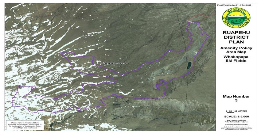
Disclaimer:
This document is for internal use and has been prepared using information and data that is sourced
from external documents and information from third parties. Where possible, we have attempted to
verify the accuracy of this material but accept no responsibility or liability for any inaccuracies or
omissions from that material that may affect the accuracy of the assessment or recommendations
made in this report. It should not be construed that we have conducted an audit of any of the
information used in this report or any of the individuals, companies or organisations consulted while
preparing the document.
We reserve the right, but are under no obligation, to revise or amend our report if any additional
information (particularly about the assumptions we have relied upon) which exists on the date of our
report, but was not drawn to our attention during its preparation, subsequently comes to light.

©Perception Planning, 2018

Report prepared by:      Kara Scott
                         Landscape Planner, Registered Landscape Architect

Reviewed by:             Rachael Annan
                         Landscape Planner, Registered Landscape Architect

2
PERCEPTION PLANNING
Table of Contents
Executive Summary ........................................................................................................................... 4
1     Introduction ................................................................................................................................. 5
    1.1    Assessment Methodology ..................................................................................................... 5
2     Context ........................................................................................................................................ 6
    2.1    The Site ................................................................................................................................. 6
    2.2    The Surrounding Landscape Character .............................................................................. 11
    2.3    Visual Catchment ................................................................................................................ 12
3     The Proposal ............................................................................................................................. 14
    3.1    Proposed Activity................................................................................................................. 14
    3.2    Planning Context ................................................................................................................. 20
    3.3    The Whakapapa Indicative Development Plan 2011 and 2017 .......................................... 20
    3.4    Potential Adverse Landscape and Visual Effects ............................................................... 22
4     Assessment of Landscape and Visual Effects .......................................................................... 22
    4.1    Overall Proposal .................................................................................................................. 22
    4.2    Gondola Alignment; Towers, Cabins, and Associated Infrastructure ................................. 23
    4.3    Bottom Terminal and Cabin Storage Building Top of the Bruce Plaza ............................... 27
    4.4    Top Terminal Building at Knoll Ridge Café ......................................................................... 29
5     Conclusion ................................................................................................................................ 31
    Appendix 1 –Summary of relevant objectives and policies .......................................................... 34

3
PERCEPTION PLANNING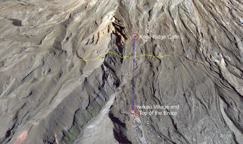
Executive Summary
This report provides a landscape and visual assessment of the proposed Knoll Ridge Gondola by
Ruapehu Alpine Lifts (RAL) extending from the Top of the Bruce Plaza to Knoll Ridge Café, at
Whakapapa Ski Area on the western slopes of Mount Ruapehu. The proposed Gondola will replace
the visitor/skier transport capacity lost to the National Chair removal.

Whakapapa Ski Area is located within the Tongariro National Park, an area identified as both a World
Heritage Area and an Outstanding Natural Landscape.             The Park is recognised for its many
landscape values, in particular; cultural, scenic, wilderness, ecological and recreation values.

Proposed development within the Tongariro National Park must be appropriate for the landscape
values of location, provide compatible use, and not detract from the ongoing protection of these
values. Under both the Ruapehu District Plan (RDP) and Tongariro National Park Management Plan
(TNPMP), ski areas have particular management to ensure any adverse effects on the environment
are avoided, remedied, or mitigated.

Both plans refer to Amenities Areas which are set out by the National Parks Act 1980 under section
15. Under the Act, Amenities Areas are set aside for the “development and operation of recreational
and public amenities and services appropriate for public use and enjoyment of the park”. The
TNPMP notes that “all major infrastructure including ski-lifts, buildings, car parks, roads, and other
major earthworks, should wherever possible, be located within the Amenities Areas, to avoid or
mitigate environmental impacts and protect the park in its natural state”

The proposed gondola will be within an existing built part of the ski area. This is within an Amenities
Area; and within a topographically incised part of the mountain that is less visible to the surrounding
landscape. This has benefits from a landscape and visual perspective in ensuring that development
of the ski area does not extend into untouched parts of the mountain, or areas with potentially high
visibility outside of existing ski area operations.

From a landscape character and visual amenity perspective; the site context, limited visibility, and
design approach of the proposal will result in an activity that is consistent with the relevant objectives
and policies of the RDP and TNPMP.

4
PERCEPTION PLANNING
1 Introduction
Ruapehu Alpine Lifts (RAL) is proposing a new gondola with terminal buildings and cabin storage
that replace the capacity lost with the National Chair removal. The proposal will introduce a new
alignment from the base area at the Top of the Bruce Plaza to the Knoll Ridge Café. This new
alignment will pass between the two Ruapehu Ski Club lodges, where a lift alignment has not
previously been. A description of the site context is provided in section 2 of this report, details of the
proposal are provided in section 3, and assessment of landscape and visual effects in section 4.

The proposed gondola terminal buildings are intended to provide an overall coherent design that
complements the existing architecture and infrastructure of the Whakapapa Ski Area. The proposed
top gondola terminal building is designed where practicable with materials that reference the
architecturally award-winning Knoll Ridge Café, which has been designed to integrate with the
surrounding landscape. The proposed bottom terminal is a large-scale prominent structure located
in the base area. It is also designed, where practicable, with materials used on the proposed upper
terminal and Knoll Ridge Café.

The proposal requires an assessment of landscape and visual effects because it is within the highly
natural landscape of Mount Ruapehu. The Ruapehu District Plan and Tongariro National Park
Management Plan require the landscape and visual effects of large scale proposed buildings, ski
lifts, and gondolas to be assessed.

This report provides an assessment of the actual or potential landscape and visual effects of the two
proposed terminal buildings and the proposed gondola alignment and associated infrastructure.

1.1     Assessment Methodology

The landscape and visual assessment methodology used in this report includes:

Background:

    •   Site visits undertaken on 31 October 2016, 20 June 2017, and 5 March 2018
    •   Photography.
        Photographs in this report were taken during the site visits, plus additional photos taken
        October 2015, January 2017, and March 2018. The photographs are used to visually explain
        the site context. The assessment is not based on the photos alone.
    •   Identifying the proposal aspects relevant to assessing the actual and potential landscape
        and visual effects.
    •   Appraisal of the existing landscape and determining the visual catchment
    •   considering the surrounding visual audience and their proximity to the site.
    •   Identifying the relevant planning provisions for assessing actual and potential landscape and
        visual effects.
    •   Identifying the actual and potential landscape and visual effects to be assessed.

5
PERCEPTION PLANNING
• Production of architect’s impressions of the proposed buildings and alignment. Photos are
taken on site using a 50mm fixed lens digital SLR camera at a fixed location. From the view
point a CAD model of the building and terrain is created using ArchiCAD v20 and over laid
on the image. (These images are intended to provide further guidance as to what the
proposal may look like in the landscape, they are not technical photo simulations).
Assessment:
• Consideration of the potential landscape and visual effects of the proposed activity (positive
and negative) against relevant objectives, policies and assessment criteria of the RDP and
TNPMP; to guide the assessment and provide a measure to assess the potential landscape
and visual effects. A summary assessment against the relevant provisions is provided in
Appendix 1.
• Consideration of the site requirements for the proposed gondola alignment, and specific
design measures proposed to avoid, remedy or mitigate potential adverse effects.
• Reference to the architect’s impressions as a guide, although it is noted that the assessment
is not based on these images alone.
Specific cultural values are not assessed in this report, as these have been assessed and consulted
in a separate process by Ruapehu Alpine Lifts (RAL).
2 Context
2.1 The Site within the Alignment
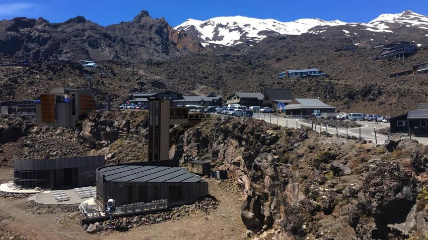
The site extends from the base area at the Top of the Bruce Plaza (1,620m above sea level), over
Hut Flat and the Waterfall to Knoll Ridge Café (around 2,000m asl) on the western slopes of Mount
Ruapehu (refer to Image 1). The proposed gondola route alignment will extend approximately 1.8km
from the base area at the Top of the Bruce Plaza, up to the west side of the Knoll Ridge Café. The
route alignment will pass in close proximity to the Ruapehu Ski Club lodges. The actual and potential
effects of this are discussed in section 4 of this report. Image 1 shows the approximate alignment
in blue, from the terminal points at the Top of the Bruce building up to Knoll Ridge Café shown in
red. The typical incised nature of the topography in between is highlighter for reference by the yellow
cross section line.
6
PERCEPTION PLANNING
Hut Flat and
                                                        RSC Club lodges

Image 1 – Aerial photo of the entrance to Whakapapa Ski Area showing the Top of the Bruce Plaza at
Iwikau Village, and Knoll Ridge Café on the upper mountain, and the approximate proposed alignment
in purple. Note: the top of the mountain is to the top of this image.

This part of the mountain is identified by Department of Conservation as part of an “Amenities Area”
under section 4.2.4 of the Tongariro National Park Management Plan, and in accordance with the
National Parks Act 1980 (shown in Image 2).

Image 2 – Ruapehu District Plan image of the Amenity Policy Area for Whakapapa Ski Area. Note the top
of the mountain is to the left of this image.

7
PERCEPTION PLANNING
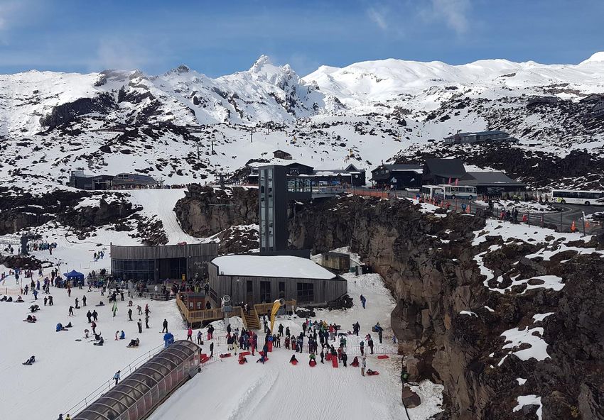
At Whakapapa, the lower Amenities Area landscape setting is highly modified, consisting of club
lodges, ski lifts and chalets, car parking spaces, cat tracks and chair storage. The density of
buildings is greatest at the Top of the Bruce Plaza, which is the entry area to the Whakapapa Ski
Area. This area currently has a mixture of administrative buildings, ticketing, café, retail, rentals, and
carparking spaces and entrance to ski lifts. Image 3 below shows the base area looking south east
from the Top of Bruce carpark.

There are also existing ski area facilities, including the Rangatira Express and Waterfall Express
Chairs, Delta Quad Chair, terminal buildings, and chair and ski area storage facilities. The recently
removed Rockgarden Chair formerly aligned parallel with the Rangatira Express.

Image 3 – View from the top ski area car park looking south east towards the Top of the Bruce Plaza at
the centre, and Happy Valley to the left. Photo taken winter 2017.

At about half point of the alignment the topography flattens at an area known as Hut Flat. Here the
has fewer lodges than at Iwikau Village. Those present within the alignment are the two Ruapehu
Ski Club lodges; with the Wanaganui Ski Club, Tararua Tramping Club lodge, and Hutt Valley
Tramping Club lodges on the upper slopes and over a ridge form Hut Flat. Other buildings within
Hut Flat include the Schuss Haus (Corona Bar), the historic Glacier Hut – the first building at
Whakapapa that now serves as a museum, and the existing infrastructure associated with the
Rangatira Chair and Waterfall Express Chair. Image 4 shows the level of built infrastructure in this
area viewing from the Rangatira top terminal.

8
PERCEPTION PLANNING

Image 4 – View from Hut Flat (left to right) the Waterfall Chair bottom terminal, Schuss Haus, Glacier
Hut (red), Ruapehu Ski Club lodge. Photo taken March 2018.

From Hut Flat up to the Knoll Ridge Café the topography is incised, being within a small valley
between the Pinnacles to the east and a smaller ridge to the west.         Images 5 and 6 show the
incised nature of the topography.

The level of built development here includes the Waterfall Express towers, over and under grounded
services, the Cat shed, Delta Quad lower terminal, Knoll Ridge Café, and Waterfall Express upper
terminal (to be removed as part of this proposal). Image 7 shows the Knoll Ridge Café and Waterfall
Express upper terminal.

Image 5 – Aerial view to Knoll Ridge Café, and yellow line indicating a cross section of the topography.

9
PERCEPTION PLANNING
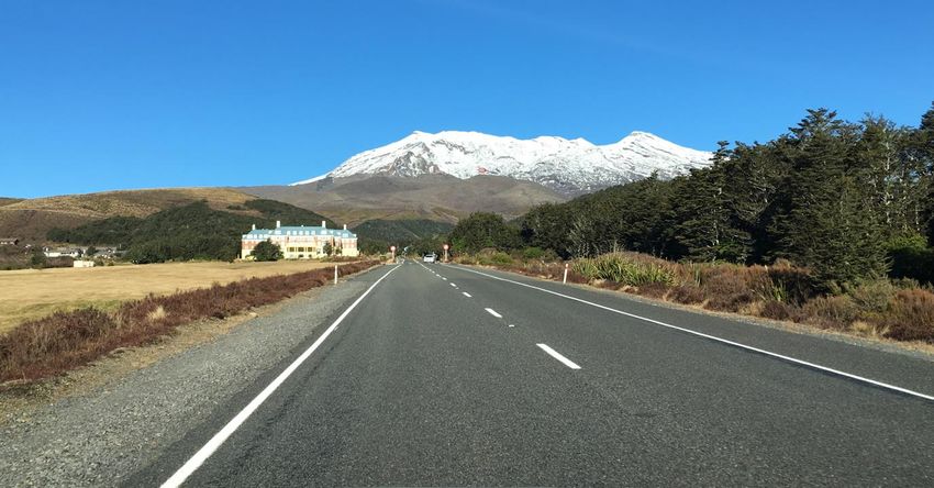
Image 6 – View from Hut Flat towards the Waterfall Express Chair, (viewing south to the upper mountain)
showing the incised nature of the topography, part of the Pinnacles (topography rising to the left), and the
smaller ridge at the edge of The Waterfall (topography rising to the right. Photo taken October 2017.

Image 7: Knoll Ridge café (left) and Waterfall Express Chair upper terminal building (right).

10
PERCEPTION PLANNING
2.2     The Surrounding Landscape Character

The surrounding landscape is the wider outstanding alpine landscape and culturally significant Mount
Ruapehu. It is a volcanic landform that rises steeply form the central plateau area and creates a
dominant land feature as the tallest peak in the North Island. The Ruapehu District Plan (RDP)
describes Mount Ruapehu as being valued for its visual and scenic characteristics particularly its
visual prominence, and for its recreational values.

The buildings within the ski area have been individually constructed at various times; the ski chalets
by RAL, and the club lodges by individual club groups. The resulting character is somewhat ad hoc
with various styles; however, the buildings tend to have similar characteristics. These include dark
colours that integrate with the summer landscape, weathered natural materials such as wood and
stone, and dark roof colours.

New and replacement buildings being constructed by RAL in the Whakapapa Ski Area have been
designed with a consistent suite of materials; primarily iron sand colour steel, corten steel, precast
concrete, weathered timber, and measures to reduce glass reflectivity. This can be seen with the
Knoll Ridge Café design, as shown in Image 8. As a result, a greater level of design coherency is
beginning to emerge at Whakapapa Ski Area which references a ‘mountain vernacular’. This has a
notable landscape and visual benefit of integrating building structures with the overall outstanding
mountain landscape.

Image 8 - Photo showing the south side of the Knoll Ridge Café, and an example of the suite of materials
being used on the Whakapapa Ski Area buildings – dark iron sand colour steel, weathered timber cladding,
corten steel, tinted windows. Photo taken October 2015.
New lift infrastructure at Whakapapa is also being constructed to minimise impact on the landscape.
The former Rockgarden Chair (which was removed and capacity replaced by the Rangatira Chair),

11
PERCEPTION PLANNING
and the former National Chair (to which this proposal replaces) both had lattice towers as shown in
Image 9.

Image 9 - Photo from 2015 showing the lattice towers of the Rockgarden Chair (upper left) and National
Chair (upper mid-right). Photo taken October 2015.

2.3     Visual Catchment

TOP OF THE BRUCE PLAZA AREA

The lower parts of the mountain have a confined visual catchment due to the intervening
surrounding topography. Views to Iwikau Village are generally confined to the immediate
surrounding area due to the incised nature of the landform, particularly around the Top of the
Bruce Road area, along with some very intermittent and distant views afforded from State Highway
47.

The main viewing audience to the Top of the Bruce Plaza is the immediate surrounding car parking
area on the Bruce Road, and views from the above club lodges.

TOP OF THE BRUCE TO KNOLL RIDGE

The visual catchment of the area from the Top of the Bruce to the Knoll Ridge varies considerably
with location and elevation. From the Knoll Ridge Café, views extend to State Highway 48 (Bruce
Road) and beyond. From these locations, the Knoll Ridge Café becomes discernible by eye; only
when approaching the Chateau Tongariro building some 6.4km away. Beyond this the building is
visually difficult to detect. From this location, the lower part of the ski area from Knoll Ridge to the
Top of the Bruce along with Iwikau Village is obscured by intervening topography.

The nearest view when ascending the Bruce Road, is at Scoria Flat where the Knoll Ridge Café,
along with the Waterfall Express Chair and Iwikau Village is located around 3.6km away. Here the
Ski Area operations gradually become more visible within the incised valley (which extends
between the two areas). Image 10 shows the approximate visual catchment for the proposed

12
PERCEPTION PLANNING
gondola. This is an approximate guide to visiblility, determined by site visits and walking the
gondola alignment.

The pink outline shows the visual catchment of the site from the Top of the Bruce to Hut Flat.
Some very distant views (12km plus) are possible to the upper parts of this area, with the visiblity
of buildings varying in different light. The blue outline shows the visual catchment for the upper part
of the proposed alignment from Hut Flat to Knoll Ridge Café, which is within a more open part of
the landscape. Here the views to the upper mountain extend to more distant views as indicated by
the opening to the top blue visual catchment area.

Image 10 - Google Earth image of the north west slope of Mount Ruapehu, showing the approximate visual
catchment (shown in pink outline, and extended views in blue) from the site (the base and Knoll Ridge Café
shown by red circles).

The Knoll Ridge café only becomes visually discernable when approaching the mountain on the
Bruce Road near the Chateau at approximately 6km away. Intervening topography blocks the
lower part of the ski area from this view. At this distance the Knoll Ridge Café can be visually
difficult to detect. Visibility varies depending on light conditions. Knoll Ridge becomes visible again
from Scoria Flat at approximately 3km away. From this distance the towers of the Waterfall
Express Chair are still difficult to visually detect. Images 11 and 12 show the views to Knoll Ridge
Café from the Bruce Road at the Chateau and Scoria Flat.

13
PERCEPTION PLANNING
Image 11 - Photograph from State Highway 48 viewing towards Mount Ruapehu and the Chateau
Tongariro. Knoll Ridge Café is highlighted with a small red circle. Photo taken October 2016.

Image 12 - Photograph from The Bruce Road near Scoria Flat viewing south to upper Mount Ruapehu.
Knoll Ridge Café and Top of the Bruce Plaza are highlighted with a small red circle. The base area (the
Rangatira Lift and proposed gondola lift bottom terminal) is not visible from this view. Photo taken October 2016.

3 The Proposal

3.1      Proposed Activity

BOTTOM TERMINAL AT THE BASE AREA

The proposed bottom terminal building will be located between the Rangatira Express Terminal and
Lorenz’s Café building in the base area past the Top of the Bruce Plaza. It will have two levels; the
upper level is for loading and unloading, and the lower level is for cabin storage. The cabin storage

14
PERCEPTION PLANNING
level is proposed to be situated below existing ground level, with the exterior facing Happy Valley
exposed. From this view the building will appear of similar height or scale as a 3 to 4 storey high
building. The building will be of a larger scale than currently seen at the base area. This is also
because the entry plaza still consists of smaller ad hoc relocatable buildings.        The Indicative
Development Plan (IDP) identifies the need to upgrade the plaza area to purpose specific buildings
that will in time change, modernise and unify the character of the plaza.

The proposed gondola lower terminal building will use the same suite of materials of buildings
emerging within the Whakapapa Ski Area landscape. This includes weathered timber cladding, dark
tinted precast concrete, ironsand colour steel roofing and cladding, accents of corten steel, and mesh
screens over glass faces (to assist in reducing glass reflectivity, as well as protect glass areas from
weather). Image 13 shows the architect’s impression of the proposed lower terminal when viewing
from the Top of the Bruce carpark, and Image 14 shows the proposed building from the upper slope
of the mountain near the former Rockgarden lower terminal. Images 15 – 17 show elevations and
plan views of the proposed building.

Image 13: Architect’s impression of north-west elevation bottom terminal building adjacent to the
Rangatira Express terminal at Top of the Bruce Plaza. Note the gondola cabins and towers are not shown
in this image, and the elevator is shown as an impression. Photo taken January 2017.

15
PERCEPTION PLANNING
Image 14: Architect’s impression of south elevation bottom terminal building adjacent to the Rangatira
Express terminal at Top of the Bruce Plaza. Photo taken March 2018.

Image 15 - Architect’s sketch of the proposed bottom terminal and chair storage building west and
north elevations.

Image 16 - Plan view of the proposed Gondola bottom terminal loading and unloading level

16
PERCEPTION PLANNING
Image 17 - Plan view of the proposed Gondola bottom terminal cabin storage level.

TOP TERMINAL BUILDING AT THE KNOLL RIDGE CAFÉ

The proposed gondola route alignment requires a new top terminal building. The proposal is for this
terminal to be adjacent to the west side of the existing Knoll Ridge café. The gondola top terminal
will replace the WFE top terminal (which will no longer be required). The proposed terminal structure
will be approximately 8.5m high at its southern extent, and approximately twice that height on the
northern approach where the ground drops away. The ground level will be raised with rocks at the
northern end of the terminal. Image 18 shows the architect’s impression of the top terminal building
adjacent to the Knoll Ridge Café. Images 19 and 20 show the top terminal elevations.

Image 18: Architect’s impression of north-west elevation towards the existing Knoll Ridge Café (left)
and proposed top chair terminal building to the right. Photo taken October 2016.

17
PERCEPTION PLANNING
Image 19: Architect’s drawing of north elevation towards the existing Knoll Ridge Café (behind) and
proposed top chair terminal building (front).

Image 20: Architect’s drawing of north elevation towards the existing Knoll Ridge Café (behind) and
proposed top chair terminal building (front).
The proposed upper terminal building has a functional use that dictates its size and shape.
Additional external cladding is proposed where practicable. To provide for visual coherence
between the existing and proposed structures, similar materials and design elements to the Knoll
Ridge Café including weathered timber cladding, ironsand colour steel roofing and cladding
(including roller doors), timber fins over windows, and accents of corten steel will be used. The
lower section of the building facing downhill has rock material to assist in ‘visually anchoring’ it to
the surrounding landscape. The design contrasts and provides an improvement to the existing
Waterfall Express top terminal which is more utilitarian in appearance, and of a larger scale than
the proposed gondola upper terminal as shown in Image 7.

Timber fins over the windows will be used to minimise the visual impact of reflections from glass
from the upper terminal station. The roof of the terminal is tinted and angled at 45 degrees. This
minimises the instances of light reflectivity to the surrounding landscape, by being angled towards
the sky.

Timber building materials will be new and will weather over time. There will be a time where timber
appears a brighter colour. This will fade over time to dull grey.

GONDOLA ALIGNMENT AND CABINS

The proposed gondola chair will consist of 14 tubular towers ranging in height from 10m to 21m
high with an average of 15m. The towers will be painted black as per ski area standard. While this
will initially appear darker than the surrounding summer landscape, it will fade overtime to similar
effect as the WFE towers. The gantries will have a similar visual effect as the Rangatira Express
gantries and are not required to be significantly different for carrying Gondola cabins when

18
PERCEPTION PLANNING
compared to chair lifts. Towers may have deflective footings where they are located to the edge of
the lahar path, which will also be painted black. There will be no floodlighting of the towers.

The proposed towers will require excavation and rock pinning. This can become visually apparent
as the colour of the excavated rock can have a lighter orange colour. Where practicable
foundations will be rock pinned, and where earth worked / excavated areas will be reinstated near
to the natural land form.

The proposed gondola cabins will be a new moving form on the mountain when compared to the
chairs. The proposed gondola cabins have a 10-person capacity. They are around the same width
as a quad chair. They will appear as moving pods with a separation distance of around 90m. Image
21 shows an example of the proposed cabins.

The alignment will pass over the Ruapehu Ski Club lodge, where a lift has not previously been. This
will change the outlook from this club lodge. The main club building is oriented to the north with the
proposed gondola passing to the south. The secondary building is oriented towards the gondola.
This has the potential to have localised effects for the RSC lodges.

The proposed alignment and towers are not intended to be lit for night skiing. Any lighting will be
for health and safety requirements, such as de-icing.

Image 21: Example of gondola cabins proposed for Whakapapa Ski Area.

19
PERCEPTION PLANNING
3.2     Planning Context

The relevant planning provisions are the Ruapehu District Plan and the Tongariro National Park
Management Plan.

In summary the relevant landscape and visual considerations are:

    •   The protection of outstanding natural features and landscapes from inappropriate
        development within the Ruapehu District Plan and protection of conservation areas
        in the Tongariro National Park Management Plan.
    •   The functional, technical, and operations constraints of activities within outstanding
        natural features and landscapes.
    •   Recognition and provision for operation, maintenance and upgrading of existing
        infrastructure within outstanding natural features and landscapes.
    •   Proposed works to conform to the Whakapapa Indicative Development Plan 2011
        and 2017 (IDP).
    •   Proposed buildings located within Amenities Area of the Tongariro National Park
        Management Plan.

3.3     The W hakapapa Indicative Development Plan 2011 and 2017

The TNPMP notes that: ‘controls and guidelines must overarch the development of ski areas. These
can be achieved by ensuring that all concessionaires prepare and review Indicative Development
Plans (IDP) for their ski areas.

In the park’s ski areas, most infrastructure is located within amenities areas. These amenities areas
are set aside to provide for the development and operation of public amenities at a scale and intensity
which is not found elsewhere in the park (see 4.2.4 Amenities Areas). It is acknowledged that
significant infrastructure is required for ski area operation which is outside existing amenities area
boundaries. Where facilities are developed, they must be developed in a manner which is compatible
with park objectives and values. Ski areas are located at high altitudes and in fragile environments,
and protecting and preserving the soil, vegetation cover, and landscape are important objectives.’

The 2011 IDP signalled a proposed gondola in the west area of the ski area, to a greenfield site
outside of the Amenities Area; to replace the capacity of the former National Chair. This alignment
included the proposal to construct a new upper café and terminal building. Following investigations
and Iwi consultation, this alignment was no longer considered desirable.

The draft 2017 IDP signals the current proposal (see image 22). From a landscape and visual
perspective; the current proposal to align the gondola from the Top of the Bruce Plaza to the Knoll
Ridge Café is considered to have better overall landscape and visual outcome to the mountain and
National Park values. This is because the current proposed alignment is retained within the existing
Amenities Area; whereas the former proposed western alignment in the indicative development plan

20
PERCEPTION PLANNING
moved into an undeveloped part of the mountain. The former alignment also proposed a new café and therefore more infrastructure within an unbuilt part of the mountain. The current proposed alignment utilises the existing Knoll Ridge Café and therefore minimises the level of additional built development. Further discussion over potential localised effects is discussed within Section 4.0 Assessment of this report. Image 22: Draft 2017 IDP, red = existing to be retained, green = new lifts, blue = approx. tuku or gift area 21 PERCEPTION PLANNING
3.4     Potential Landscape and Visual Effects

The relevant actual or potential effects of the proposed development are;

    •   New lift alignment within the Amenities Area to a location where one does not
        currently exist changing the level of built character for this part of the mountain.

    •   Retaining the former National Chair alignment, which is in a more visibly
        prominent part of the mountain, as open space.

    •   Retaining the top of the amphitheatre as open space (no longer proposing the
        gondola or new café into this area)

    •   Taller cable towers associated with the proposed gondola route when compared to
        existing lifts at Whakapapa.

    •   Introduction of cabins and potential for greater visibility in the landscape when
        compared to existing chair lifts at Whakapapa.

    •   Landscape and visual effects of a new proposed large-scale lower terminal
        building in the base area where one does not currently exist.

    •   Proposed upper terminal with greater landscape and visual benefits to the existing
        Waterfall Express upper terminal that will be removed.

4 Assessment of Landscape and Visual Effects

4.1 Overall Proposal

The proposed Gondola replaces the facilities and capacity taken by the National Chair (NC) and is
consistent with the draft 2017 IDP. The proposed alignment in my view has a notable landscape
and visual benefits in comparison to the previous 2011 IDP and former National Chair Alignment.

The proposal in the 2011 IDP extended the proposed gondola out of the Amenities Area, and into
an undeveloped part of the mountain, requiring an additional café and terminal building to be
constructed. The former National Chair alignment was within the Amenities Area, however it
extended into a more visibly prominent part of the ski area.

Policy 5.2.1.2 of the Tongariro National Park Management Plan sets out that all major infrastructure
including buildings is to be located within this Amenities Area (while exception is made for ski lifts,
which may be possible to locate outside of the Amenities Area if considered appropriate). This
proposed gondola maintains an alignment within the Amenities Area and utilises existing ski services
such as the Knoll Ridge Café and replacing the Waterfall Express top terminal building (this will no
longer be required under the draft IDP). The proposed development is consistent with this policy.

22
PERCEPTION PLANNING
Assessment of localised landscape and visual effects of the proposed gondola infrastructure and
buildings is providing in the following sections.
4.2 Gondola Alignment ; Towers, Cabins, and Associated
Infrastructure
While the proposed gondola will replace the National Chair in terms of levels of infrastructure; it will
introduce a lift alignment where one does not currently exist. The area of the proposed alignment
is a relatively visually confined location to the surrounding ski area, due to intervening topography.
The upper portion at the top of the Waterfall to Knoll Ridge becomes visible to more distant views
such as from the State Highway 48 approaching Whakapapa Village and from the Bruce Road at
Scoria Flat (refer Images 11 and 12). Overall the proposed gondola will be primarily visible to the
immediate surrounding area and is viewed in the context of the more intense development of
Iwikau Village – including club chalets, roading and parking, ski infrastructure and existing ski area
buildings. Distant views from State Highway 48 will be some 6km away and from this distance the
gondola will be visually difficult to detect.
Seasonally, viewing the proposal in the summer landscape is potentially more sensitive than viewing
in the winter landscape. This is because in winter the infrastructure associated with the ski area is
typically viewed in the context of ski area activities, and snow raises the apparent ground level to
cover footings and over ground services. This is not to say that winter views are not important, as
those using the ski area still enjoy the natural values of the mountain and National Park, and there
are winter visitors to the park who do not ski, but rather hike, mountain climb and sight-see. The
summer views tend to be more sensitive because the infrastructure is not viewed in the context of
taking part in snow-based activities. The user groups of summer hikers and sight-seers visit the
mountain for its natural beauty and open space recreation values (and without typically using much
of the ski field infrastructure). To appropriately reduce landscape and visual effects, ski area
infrastructure needs to be sensitively (discreetly)located and designed.
Both the Ruapehu District Plan and Tongariro National Park Management Plan anticipate gondolas
and chairlifts on the ski area and within the Amenities Area; so long as any adverse effects are
avoided, remedied or mitigated. The proposal overall results in a net reduction in towers in the ski
area. Potential adverse effects that could arise would be from inappropriate tower locations or cabins
with bright colours or highly mirrored glass.
TOWERS
The proposed towers are larger on average than current chair lifts at Whakapapa, however they
are not significantly larger to those of the Waterfall Express as a comparison. The average height
of the Waterfall Express is 11.3m and the average height of the proposed gondola is 14.8m.
Fewer towers are required for the proposed gondola than current chair lifts on the mountain. As a
comparison the existing Waterfall Express has approximately 1 tower per 65m distance, and the
proposed gondola has approximately 1 tower per 135m distance. This, in my view, is a positive
23
PERCEPTION PLANNINGoutcome of replacing old infrastructure with new on the ski area that reducing the frequency of built structures in the landscape along the proposed gondola route. Like the existing towers at Whakapapa; the proposed gondola towers will be tubular, with a diameter of approximately 1m. Previous iterations of the proposed gondola investigated included options for lattice towers. The lattice towers create a more industrial character to the mountain. In my view this is characteristic of the former Rockgarden Chair lattice towers. In my view, the proposed gondola tubular towers fit better with the high natural character of the mountain. The DoC approved standard is for towers to be painted black. This finish at first appears as a stark contrast with both summer and winter landscapes. Over time the black fades to a dull dark brown that blends with the summer mountain landscape; as seen with the Waterfall Express towers. The exposed metal colour of the gantries over time also fades to a dull grey. This approach in my view will be effective and appropriate for the proposed gondola towers, so that the colour also fades overtime to the tones of the summer landscape. All tower foundations are recommended to be painted black including towers requiring additional foundation structures for lahar path protection. Distant views may be available in certain light conditions to the upper alignment where the towers and cabins near Knoll Ridge Café – particularly when ascending the Bruce Road. These distant views to the proposed Gondola towers will not be notably different to the existing effects of the WFE with some towers being less obvious due to the alignment being lower on the topography when viewed from this location. Image 12 shows the existing view to the Knoll Ridge Café from Scoria flat – the Waterfall Express towers are indiscernible to the naked eye from this location. The tallest proposed tower is number 11 at 21m tall near the top of The Waterfall, and at this point as a comparison, it will be approximately twice the height of the nearest Waterfall Express Tower. Here, the location of proposed tower 11 is sited closer to and below the cliff face directly to the west. The height of cliff rising from the base of tower 11 is around 32m. This will enable a backdrop of topography to be maintained to the tower when viewing from afar. Therefore the proposed tower in this location will not exceed the height of a prominent ridgeline or spur. This tower will appear prominent when viewing in close proximity, however it will also be viewed when in context of the ski area. The nearest view outside of the ski area to this tower is beyond the mountain from more than 12km away. These viewpoints will be too distant to visibly detect the upper towers. Tower foundations will require excavation in some sites. I understand that the hole for the tower foundations almost perfectly matches the size of the foundation assuming the ground conditions are suitable to support a steep batter. The method is termed "pour to country" which means no boxing is used for the concrete work. On the lower mountain this may not be possible if the soil is weak however the excess material is backfilled into the hole as soon as the boxing is removed off the concrete. To summarise, the excavation is the same as the foundation size in most cases. The proposal is for all excavated materials and excavated sites to be reinstated as close as practicable to their natural form. Where towers are on solid rock there is the ability to rock pin, 24 PERCEPTION PLANNING
subject to testing on site. All excess cut material will be distributed around the tower foundation
and in most cases used as surcharge loading to disguise most of the foundation and hide them
from sight.

I understand that in the lower area of the proposed route alignment the excess material can be
distributed in a way that is not noticeable as there is a lot of existing loose rock on the ground
naturally. Where blasting is required in areas that are comprised of welded rock (if rock pining is
not practicable) there is less ability to disguise the blasted rock fragments. Surrounding weathered
rock will be used where practicable to cover blasted rock areas, and excess excavated, or blasted
material will be used in the rehabilitation of the Waterfall Express tower sites.

Attention will need to be paid to the colour of rocks when placing rocks around the tower
foundations after completion of foundation construction. For towers with more prominent footing
locations it is recommend reinstating earth worked areas with weathered rock as well as excavated
rock where practicable, to assist with blending the colour of excavated rock into the surrounding
summer landscape.

There will be temporary effects associated with the construction phase of the towers and buildings
within the proposed alignment. The gondola will require a material ropeway construction to run the
new cable. This will use the proposed tower foundations and will be within the height and
maximum span envelope of the new gondola. From a landscape and visual perspective these
temporary works will be no more prominent than the finished gondola alignment and cable and in
my view are an anticipated part of operations on the ski area and will have temporary effects
limited to a few months over the construction period.

GONDOLA CABINS

The proposed gondola cabins have 10-person capacity and will have a separation distance of around
90m. They are around the same width as a quad chair and narrower than a six-seater chair. The
gondola cabins will be approximately 2.3m - 2.8m wide by approximately 2.4m high. In comparison,
the Rangatira Chairlift quad chairs are 2.33m wide and 1.79m high. The proposed cabin sizes are,
in my view, appropriate given their compact form and are of an appropriate size for the National Park
character and values.

To ensure the visual nature of the cabins is not highly prominent in the landscape; the exterior of the
cabins is recommended to be painted in colours approved by DoC for the summer landscape. Mirror
or highly reflective glass is to be avoided, as is advertising that may cover the cabin in bright or
obtrusive colour. In my opinion, incorporating these measures, will mean that the visual impact of
the proposed gondola cabins, when viewed from outside of the ski area, is not anticipated to be
notably different to a chair lift.

RSC LODGES

The proposed gondola route alignment will pass between the two Ruapehu Ski Club (RSC) lodges
and will potentially be visible to other lodges within the Amenities Area. This will introduce a new lift
and cabin movement between the two lodges where there has previously been no lift alignment.

25
PERCEPTION PLANNING
Visitors to the Ruapehu Ski Club lodges will experience the proposed gondola cabins in closer
proximity than the current ski infrastructure. This will notably change the outlook for these two
lodge buildings, more so the secondary lodge, given its orientation towards the proposed route
alignment. Views from the main lodge are oriented to the north and east and the Gondola will pass
behind this building, although views will still be available to the moving cabins. The secondary
lodge will have direct views of the gondola cabins and overhead wire. The gondola cabins will be
elevated above around 13m above the ground level between the RSC buildings, therefore avoiding
cabin occupants from being able to look directly into the lodge windows. Proposed tower 7 at 13m
high will be located around 80m to the north and will potentially be seen against the skyline when
viewed from the RSC lodges.

The desire and policy directive to locate ski infrastructure within the Amenities Area sets up
potentially negative effects for club lodges already established within this area. While overall
landscape benefits are achieved to the mountain and National Park by limiting built development
and ski infrastructure to the Amenities Area, inevitably club lodges within this area will experience a
notable localised change in outlook and character where new alignments are proposed.

There are no methods for the proposed alignment that can completely mitigate this change in
outlook for the RSC lodges. This proposal will change the character and amenity for occupants of
these two lodge buildings, and potential other lodges over the brow of Hut Flat. The alignment was
designed to locate towers at the maximum distance from the RSC buildings to reduce effects on
the club owners/occupiers. The design approach taken ensures the gondola is designed as
sensitively as it can be for the mountain and overall National Park. The design approach will assist
in minimising any potentially adverse effects of the proposed alignment to the RSC lodges.

The potential effects of the proposed gondola on the RSC lodges needs to be weighed up against
the effects of locating ski area infrastructure within the Amenities Area, and the overall landscape
and visual benefits that result to the wider mountain landscape as a result. In my opinion, the
proposed gondola location within the Amenities Area, and within a less visible part of the overall
landscape compared to the former National Chair alignment, will enable overall greater landscape
and visual benefits. In my view, the proposed alignment is consistent with the policy direction of the
RDP and TNPMP.

In summary; the proposed gondola alignment is considered appropriate. The reasons for this are:

    1. the proposed gondola is within the Amenities Area and an already modified part of
        the mountain,

    2. the proposed alignment is within an incised valley that is mostly visually obscure
        from the surrounding Tongariro National Park, and

    3. the proposed alignment results in the area formally utilised as the National Chair
        to remain as a part of the mountain restored to open space and its original natural
        character.

26
PERCEPTION PLANNING
Overall the proposed alignment is considered to have greater landscape and visual benefits to the
previous IDP. This is because:
• The proposed alignment is confined to existing infrastructure and facilities areas
being the base area and the Knoll Ridge Café, versus the previous alignment
which extended the Gondola into a greenfield site and undeveloped part of the ski
area.
• There will no longer be an additional café or terminal building to the upper
mountain – the proposed gondola top terminal building will replace the WFE top
terminal, and the existing Knoll Ridge Café will provide for the upper mountain
facilities to the gondola.
• The proposed gondola is designed to provide an overall landscape and visual
improvement on the existing ski infrastructure, including a lower profile upper
terminal compared to the existing WFE upper terminal, and using design
materials and colours on the buildings that fit with the new development on the ski
area.
• The gondola uses compact cabins that require infrastructure akin to typical
chairlift infrastructure in the ski area; i.e. no need for lattice towers. While some
of the towers will be taller than the existing WFE, overall the site being within the
Amenities Area and being incised in nature has considerable landscape and
visual benefit over the previous gondola alignment or following the historical NDC
alignment.
4.3 Bottom Terminal and Cabin Storage Building Top of the Bruce
Plaza
The lower terminal is sited within the base area at Iwikau Village and near the entrance of the ski
area and within the Amenities Area. It effectively replaces the two terminal structures associated
with the National Chair, although it is much larger than these structures.
Images 11 and 12 show an architect’s impression of the building in the summer landscape;
viewing from the carpark at the Top of the Bruce and viewing from the slope above at the former
Rockgarden Chair terminal where summer walking occurs. In winter, snow will accumulate so that
the loading zone is closer to level with the surrounding base area.
The proposed gondola lower terminal consolidates the structures of gondola lift and cabin storage
under one roof, placed within the base of the existing ski entrance area. The proposed lower
terminal with cabin storage will be a large building particularly when viewed in relation to existing
buildings in the area – the Rangatira lower terminal and snow factory.
27
PERCEPTION PLANNINGIn my opinion the location of the lower terminal within the cluster of existing buildings at the base of the ski area and within the Amenities Area, has far greater overall benefits than ‘scattering’ built structures to less developed parts of the mountain; as was the case with the National Chair. This approach is consistent with the Tongariro National Park Management Plan 5.2.5 Introduction on building development; that “Clusters of buildings are preferable to individual buildings scattered across the ski area landscape.” It is also consistent with the TNPMP Policies 5.2.5, to integrate compatible facilities under one roof, concentrate building development to a minimum ski area servicing point. The building has functional requirements that dictate its size. To minimise the surface area of disturbance the building has been designed with cabin storage under the loading zone. This will create a taller structure in the landscape and will extend into the escarpment below when viewed from the Top of the Bruce Plaza. As a result, this will have a less visible footprint particularly when viewed from the upper slope. This is due to the proposed siting of the cabin storage underground in this area. In my opinion, while the proposed building will change the character of the escarpment above Happy Valley; this is an already highly modified part of the mountain that has been previously excavated for cat track access. The proposed building will be viewed in the context of the surrounding intensive base area operations where there is already a high level of development, and in my view this type of activity is an expected part of Ski Area operations. The proposed lower terminal building is designed to integrate with future buildings on the ski area. This includes using colours and materials from the suite of design features beginning to emerge at Whakapapa, such as weathered timber, corten steel, and dark iron sand roofing. Timber will be new at the time of construction. This will create an initial lighter yellow colour to the timber. This will fade and weather over time to a silvering effect that will appear more consistent with the natural colours and hues in the surrounding landscape. The proposed building will appear out of character with the existing buildings in the base area including Lorenz’s Café, ticketing and offices. The existing buildings have been developed over time in an ad hoc manner to older building standards; many of which are relocatable buildings and not built for purpose or with the site characteristics in mind. The IDP has signalled a long-term future upgrade of the plaza. The detail of this upgrade is not yet determined. However, in my view, should the approach be to continue to upgrade buildings in Whakapapa akin with the bespoke design seen at Knoll Ridge Café; then the proposed gondola lower terminal will be cohesive with the character of potential future plaza upgrades. While it is not possible to integrate closely with the natural contour of the site given the functional requirements of the building; it is within an already highly modified part of the mountain that has been set aside for ski area operations. The proposed building will not be sited on a ridgeline and will not be prominent on the skyline when viewed from a distance. 28 PERCEPTION PLANNING
The proposed base area is visually confined to the immediate surrounding area. Views will not be
obtained until the viewer is within close proximity of the site due to intervening topography, and at
this point it will be viewed in the context of the surrounding ski area operations including club
chalets, roading and parking, ski infrastructure and existing ski area buildings. In contrast to this, if
the proposal were to follow the alignment of the original National Chair, or the alignment in the
previous IDP outside of the Amenities Area; this would place new infrastructure into part of the
mountain that is more visible to surrounding views and away from more intense ski area
infrastructure. In my view this would have an adverse impact on the landscape.

The proposed site is a brown field development; it is already highly modified. The proposed
development, while introducing a new large-scale building, will be limited to the existing modified
area and will not result in pristine areas of the mountain being developed.       Objective 5.2.3 of the
Tongariro National Park Management Plan is to concentrate the intense land use of base areas on
already-disturbed areas, and Policy 5.2.3.13 is for new developments in the base area to modify a
minimum area of natural topography consistent with planned functions. The proposed development
is consistent with this policy.

In summary; the proposed bottom terminal and cabin storage building is considered appropriate.
The reasons for this are:

    1. The proposed building is appropriately located in an area of the mountain that is
        set aside for intensive ski area infrastructure, and the base area is the appropriate
        location to provide for a building of this scale and nature.

    2. The proposed building will combine compatible uses (cabin storage, loading and
        unloading) under one roof as opposed to being disjointed throughout the plaza.

    3. The proposed building uses a design and suite of building materials bespoke to the
        Whakapapa Ski Area and colours designed in response to the mountain character,
        which over time will improve on the ad hoc nature of the existing plaza buildings.

4.4 Top Terminal Building at Knoll Ridge Café

The proposed gondola upper terminal will be a new building in the mid-upper part of the mountain.
It will effectively replace the Waterfall Express Chair upper terminal, which will no longer be
required in future upgrades under the draft IDP. The proposed upper terminal will have a lower
profile and smaller footprint than the Waterfall Express upper terminal and will be sited in closer
proximity to the Knoll Ridge Café. This is consistent with TNPMP Policy 5.2.5.2 Building
development will be concentrated at a minimum number of ski area servicing points.

The proposed upper terminal building has a functional use. Proposed external cladding is
introduced to provide shelter and assist in architecturally integrating the upper terminal with the
Knoll Ridge Café. This includes using similar materials and design elements to the Knoll Ridge
Café with timber cladding that will be allowed to weather over time, and natural rock cladding at the

29
PERCEPTION PLANNING
base to integrate with the site. There will still be elements of the proposed upper terminal that look
different to the Knoll Ridge Café design due to its functional requirements. For instance; the
external design cladding does not cover the top of the terminal where the lift structure is and will
have a more curved finished. This approach will enable the lowest possible front profile of the
building.
This contrasts with the Waterfall Express top terminal which is a larger structure and more prominent
on the downward slope. The Waterfall Express Chair was constructed in the 1980s and is more
utilitarian with less sensitive landscape design that the Knoll Ridge Café and proposed gondola
terminal building. The Waterfall Express top terminal has a greater separation to the Knoll Ridge
Café and the effect of this is a more disbursed configuration in the landscape.
The proposed gondola upper terminal is designed to have greater landscape and visual integration
than the existing WFE top terminal by:
• Being sited in closer proximity to the Knoll Ridge Café and therefore consistent
with TNPMP Policy 5.2.5.2 Building development will be concentrated at a
minimum number of ski area servicing points
• Using materials that assist with integration of the building with the site by using
natural timber cladding and tinted windows that will weather over time and visually
connect with the Knoll Ridge Café, and stone façade on the lower portion of the
building to integrate with the surrounding summer landscape (in contrast the WFE
chair is over 3 storeys high with solid timber cladding, and foundations are not
integrated with the surrounding landscape). This is consistent with TNMP Policy
5.2.5.3 Buildings will be designed and sited to harmonise with other buildings and
with the natural contour of the site.
• The proposed upper terminal is not sited in a location where it’s profile will be
prominent on the skyline when viewed from a distance. A backdrop of
topography is maintained. This is consistent with TNMP Policy 5.2.5.4 Buildings
should not be sited in locations where their profiles would be prominent on the
skyline when viewed from a distance. Applications to undertake infrastructure
development on ridge-lines should be declined.
The proposed upper terminal and Knoll Ridge Café are not combined under one roof and therefore
do not meet Policy 5.2.5.1 of the TNP Whenever possible, integration of compatible facilities and /
or uses will be required. In this instance the proposed design is not considered necessary to place
under one roof. This is because integration under one roof would create an overall larger structure
in the landscape with additional height to the upper terminal building. Given the proposed upper
terminal’s close proximity to the Knoll Ridge Café; visually it will appear from most viewing points
as a combined structure. This contrasts with the existing WFE upper terminal which is viewed in
the landscape as separate structure, and therefore exasperating the effect of build structures
spread throughout the landscape (refer to Image19).
30
PERCEPTION PLANNINGYou can also read