St Clement Parish Neighbourhood Development Plan 2019 2030 - Cornwall Council
←
→
Page content transcription
If your browser does not render page correctly, please read the page content below
St Clement Parish
Neighbourhood Development Plan
2019 - 2030
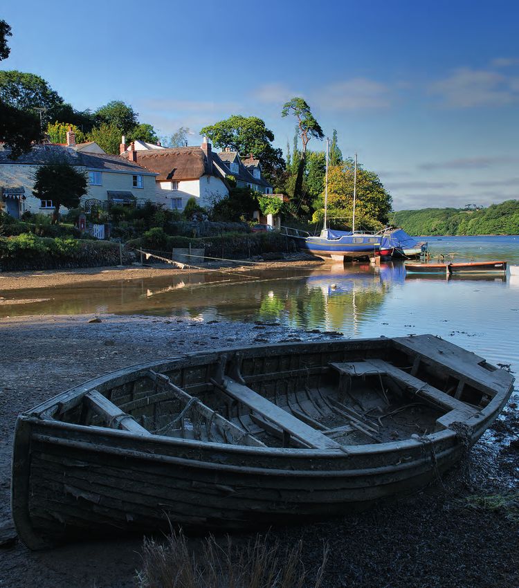
© Photo Copyright Keith Littlejohns
January 2020
KL Communications Design for Printing t: +44 (0) 1872 520 503 e: info@kl-c.com Project: St. Clement Neighbourhood Plan logo Client: St. Clement Neighbourhood Plan Date: 2016-10-20
Contents
1.  Introduction                                                                             4
2.  St Clement Neighbourhood Development Plan (NDP) – The Preparation Process                5
          Getting this far                                                                   5
          What next?                                                                         5
3. St Clement NDP - Supporting Documentation                                                 6
4. St Clement: Background                                                                    6
          Malpas                                                                             6
          Tresillian                                                                         7
          St Clement                                                                         7
          Buckshead and surrounding area                                                     8
5. St Clement NDP: The Vision                                                                8
6. St Clement NDP: Objectives                                                                9
          a) Housing and Communities Objective                                               9
          b) Economic Objective.                                                             9
          c) Community Facilities Objective.                                                 9
          d) Natural Environment Objective.                                                  9
          e) Highways, Transport and Public Rights of Way Objective.                         9
7. St Clement Housing Statement                                                             10
          NDP Housing Requirement                                                           10
          Delivering the St Clement Housing Requirement                                     11
8. St Clement NDP: Policies                                                                 12
          Policy 1 - Housing Development within the settlement boundary                     13
             Policy 1 Justification                                                         13
             Policy 1 Intention                                                             14
          Policy 2 – Housing Development outside settlements boundaries (exception sites)   15
             Policy 2 Justification                                                         15
             Policy 2 Intention                                                             16
          Policy 3 – Infrastructure                                                         17
             Policy 3 Justification                                                         17
             Policy 3 Intention                                                             18
          Policy 4 – Highways, Transport and Public Rights of Way (PROWS)                   19
             Policy 4 Justification                                                         19
             Policy 4 Intention                                                             20
          Policy 5 – Community facilities (including open space)                            21
             Policy 5 Justification                                                         21
             Policy 5 Intention                                                             22
          Policy 6 – Heritage                                                               23
             Policy 6 Justification                                                         23
             Policy 6 Intention                                                             24
          Policy 7 – Landscape and Natural Environment                                      25
             Policy 7 Justification                                                         25
             Policy 7 Intention                                                             27
          Policy 8 – Business and Commerce                                                  28
             Policy 8 Justification                                                         28
             Policy 8 Intention                                                             29
9. Glossary & Abbreviations                                                                 30
Appendix - Maps                                                                             31

                                                     3
1. Introduction

1.1. This document is the final St Clement Neighbourhood Development Plan (NDP). It presents
     the Vision and Objectives for the St Clement Parish over the NDP period to 2030 and
     presents planning policies which seek to enable delivery of this Vision and these Objectives.

1.2. Neighbourhood Planning builds on the National Planning Policy Framework (NPPF) and the
     Cornwall Local Plan: Strategic Policies Development Plan Document (Local Plan), to give an
     extra level of detail at the local level. The St Clement NDP has been developed to ensure
     that future growth and development throughout the Parish is led by the local community.

1.3. St Clement NDP runs in tandem with the Local Plan, which runs to 2030. It is appropriate that
     it should have the same end period and therefore it will be reviewed and updated in 2030.
     The Parish Council may however deem it necessary to update the NDP at an earlier date if
     circumstances warrant any earlier review.

1.4. This document is supported by a number of other documents and background information
     which are referred to throughout. These supporting documents can be accessed at https://
     stclementplan.wordpress.com. A glossary and abbreviations section is included at the back
     of this document for ease of reference (Section 10).

1.5. St Clement NDP applies to the area is that covered by the St Clement Parish Council and as
     shown in the Appendix.

1.6. St Clement is situated in the middle of Cornwall and is part of the Truro and Roseland
     Community Network Area (CNA).

1.7. The community of St Clement was consulted by the parish council and there was support to
     develop a NDP in order to provide for appropriate development which conserves the rural
     character of the parish and its natural and historic environment. Development should also
     reflect the character of each settlement, and retain their distinctive character (see Report to
     the February 2015 meeting of St Clement Parish Council).

1.8. Once finalised and adopted by Cornwall Council (CC), the planning policies presented in this
     NDP seek to positively plan for the future of St Clement and will be used and acted upon by
     CC planning officers, landowners and developers through the development process;
     providing clarity on the community’s needs and aspirations.

                                                    4
St Clement Neighbourhood Development Plan (NDP)

2. The Preparation Process

Getting this far.
2.1. The preparation of this NDP has been led by the St Clement NDP Steering Group. This group
    comprises Parish Council representatives and five volunteers who are residents of the parish.

2.2. The preparation of this NDP has been informed throughout by a comprehensive programme
     of consultation. Consultations have been taking place over the last three years. These have
     included:

   • Public meetings, parish wide questionnaires and exhibitions

   • Creation of a dedicated website https://stclementplan.wordpress.com

   • Regular updates through the TRAM (village magazine in Tresillian)

2.3. All the consultakons have been summarised in the ‘Consultakon Statement’, as required by the
     formal NDP legislakve requirements; this is available at hmps://stclementplan.wordpress.com.

2.4. The outcomes of the various consultakons has highlighted the key priorikes of:

   • Housing growth within villages whilst recognising issues relakng to parking and second home
     ownership in Malpas
   • Adequate infrastructure of all services including sewage and broadband
   • The need for adequate highways, transport and pedestrian links including the proteckon of
     Public rights of way
   • To promote informakon recreakon opportunikes and access to the river
   • To protect community facilikes
   • To protect the listed and historical assets to the parish
   • The landscape is very important to the community to keep its rural disknct feel
   • To support exiskng businesses

What next?
2.5. Following submission of this final plan to Cornwall Council for their consideration it will be
     consulted on before being sent to an independent examiner (mutually agreed by Cornwall
     Council and the St Clement NDP Steering Group) who will check the NDP to ensure it conforms
     with legislation, policies, designations and any other relevant documents. At that stage, the
     independent Examiner may recommend that the NDP is amended before continuing to the
     referendum stage.

                                                      5
2.6. The NDP will be subject to a Referendum, in order to gauge community support. The NDP will
     only be adopted by Cornwall Council if the majority of those voting in the Referendum support
     it.

2.7. Once adopted, the policies contained within the St Clement NDP will have to be taken into
     consideration when Planning Officers determine future Planning Applications.

3. St Clement NDP - Supporting Documentation

3.1. St Clement NDP, is supported by a variety of further documents and information, which are
     often referred to in this document as the ‘Evidence base’. The key supporting documents
     referred throughout this NDP are the ‘St Clement Local Landscape Character Assessment’ and
     the ‘St Clement Housing Needs Survey’ as well as the household survey and various public
     consultation events.

3.2. All supporting documents and evidence base are made available at https://
     stclementplan.wordpress.com, alternatively hard copies can be made available by request to St
     Clement Parish Clerk.

4. St Clement Parish: Background
4.1. St Clement Parish is surrounded by seven other Parishes (see Map I in Appendix). It is mainly a
     rural parish divided by the railway line. There are three main settlements - Tresillian, St
     Clement and Malpas villages are south of the railway line, and Buckshead with scattered
     residences in Bodrean, Polwhele, Laniley and Frogmore are to the north of the railway.

4.2. The predominant land of the parish is of an agricultural nature comprising arable and grazing
     farmland with belts of forestry and woodland abutting the river valley and rising up over the
     steep-sided valleys, sloping land and plateaux. The three main settlements nestle along the
     sides of the Tresillian River, which joins with the Truro River at Malpas whilst the remainder of
     the parish on the high land has small areas of sporadic development particularly in the
     Buckshead region in the northern area of the parish.

Malpas
4.3. The village of Malpas lies at the end of Malpas Road, approximately two and half miles from
     Truro City. For more than a 100 years, Malpas has provided affordable housing to the families of
     river-men, sailors, mine workers and farm labourers. This population was served by the regular
     passage of transport boats and a ferry service across the Tresillian River. Accordingly, the main
     housing stock of Malpas consists of terraced or semi-detached homes of what were, until
     recently, an affordable kind. Such homes are mainly clustered around the place of deepest
     water [now a marina], where the lane dips nearly to the level of the shore, close to the Heron
     Inn.

4.4. Homes through the length of the village, are no longer ‘affordable’, and generally, there is now a
     rising proportion of second-home owner occupancy. Characteristically in Malpas, housing sites,

                                                    6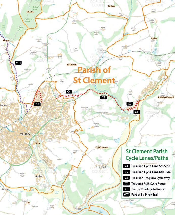
along the length of the village, have tended to cluster on a narrow band of rising land, between
    the estuary bank and the steep slopes of the surrounding, partially-wooded hills.

4.5. The garden land to the rear of village habitation, usually consists of small steep plots which run
     up to the top of the valley, where it meets an AONB landscape of pasture and arable fields. The
     soils are mainly soft loams with Devonian rock outcrops together with slates and shales. Mud
     flats compose the beds at marine levels, exposed at low tides.

Tresillian
4.6. Tresillian village lies adjacent to the upper reaches of Tresillian River roughly at the limit of the
     tidal reach. The navigability of the river and its location on the main highway through to Truro,
     owes much to the historical development of the village through river born trade and the
     establishment of various businesses adjacent to the river, which relied on goods both delivered
     by water and the distribution of goods and materials to outlying settlements.

4.7. Owing to its tight location at the base of the river valley, development has been restricted to
     the flood plain and lower slopes of the land on the northern side of the river, the land to the
     south being part of the Tregothnan Estate and comprising predominantly woodland.

4.8. The existing village boundary presents a compact, rounded settlement. Free of any significant,
     sporadic or ribbon development providing good access to village facilities from most areas. The
     land to the south of the existing boundary comprises agricultural land rising up on the valley
     side.

4.9. The Parish boundary formed by the river at the eastern end of the village bisects a small portion
     of the settlement, which lies in the parish of St Michael Penkivel.

4.10. The historical character of the village is restricted to the narrow corridor of the A390 highway
     as it passes through the village and contains a number of C18th and C19th terraces, a thatched
     public house, Toll house, Oast house, Old School house together with some detached houses of
     architectural interest. The Church, Tregothnan Estate Gate House and other notable dwellings
     are located in the section of the village, which lies in St Michael Penkivel Parish.

4.11. The greater majority of the dwellings in the village lie on the northern slope of the river valley
     served by a pattern of estate roads and are predominantly modern semi detached properties
     built in the 60s, 70s and 80s apart from the small housing association development consisting of
     two storey dwellings clustered around a small cul-de-sac. There are two areas of traditional
     council houses at either end of the village.

St Clement
4.12. St Clement village lies abutting the northern bank of the Tresillian River nestled in a small
     tranquil inlet sheltered by woodland. The village is designated a Conservation Area to protect its
     unique character as a historic waterside settlement and comprises a medieval church, thatched
     cottages, typical Cornish slate and cob dwellings and many other architectural features

                                                     7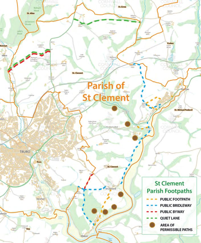
Buckshead and surrounding area
4.13. This area is predominantly agricultural with and few scattered hamlets and agricultural
     properties. It has some of the best views of countryside in the Parish, with plateaux, gentle
     slopes and steep valleys with streams at the bottom.

4.14. Buckshead itself is a small hamlet of approximately 12 houses bordering the A39 and up
     against the Truro City Boundary. Polwhele has significant employment with DEFRA
     Administration buildings and a workforce of some 90 staff. Only a short distance away is
     Polwhele House School, a private infant/junior school for approximately 100 children and
     Penmount Crematorium which is busy with visitors

4.15. Farms within the area range from small to medium holdings, some with larger houses and
     some with more traditional agricultural cottages.

5. St Clement Parish NDP: The Vision
5.1. Every plan has an aim and for the St Clement Parish NDP the aim is for the policies of the NDP
     to help achieve a ‘Vision’ for St Clement Parish by 2030. The Vision for the St Clement Parish is
     as follows:

                                   THE VISION for St Clement Parish

       “In 2030, St Clement parish will conknue to be defined by its natural environment and
           heritage, parkcularly the largely informal recreakonal opportunikes it affords. Its
        villages will be socially stable, with healthy balanced communikes. There will be local
         economic opportunikes as well as access to wider economic opportunikes in Truro
                                        and neighbouring parishes”

5.2 In order to achieve this Vision a number of ‘Objectives’ are set and then, in order to achieve
    these Objectives, a number of Policies are set out. It is these policies that will have to be taken
    into consideration when Planning Officers determine future Planning Applications, thereby
    helping to turn the aspirations of the NDP into a reality. The way the Vision, Objectives and
    Policies link together is illustrated in Figure 1.

                                                    8
THE VISION for
                                                            St Clement

                  OBJECTIVES                                OBJECTIVES                OBJECTIVES

       POLICIES                    POLICIES                    POLICIES    POLICIES            POLICIES

Figure 1: St Clement NDP: Links between Vision, ObjecVves and Policies

6. St Clement NDP: Objectives
6.1 The Objectives of the St Clement NDP are as follows:

      a) Housing and Communities Objective.
6.2. To encourage healthy and sustainable communities with new housing for local people within
     settlement boundaries, principally located in the village of Tresillian;

      b) Economic Objective.
6.3. To maintain local employment opportunities, particularly in agriculture, and encourage suitable
     small scale business development;

      c) Community Facilities Objective.
6.4. To maintain community facilities to support the social fabric of each village;

      d) Natural Environment Objective.
6.5 To conserve and protect the natural and historic environment with enhanced access to largely
    informal recreation opportunities where appropriate and having regard to the Area of
    Outstanding Natural Beauty (AONB) and other environmental designations;

      e) Highways, Transport and Public Rights of Way Objective.
6.6. To maintain good access to Truro and neighbouring parishes and ensure any future
     development does not have a detrimental impact on accessibility, including rights of way.

                                                                   9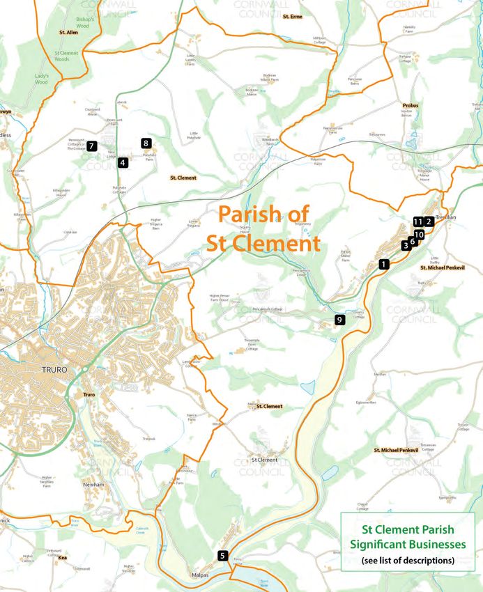
7. St Clement Housing Statement

NDP Housing Requirement
7.1. Cornwall’s Local Plan apportions 1200 dwellings to be delivered in the parishes that make up
     the rural area of Truro and Roseland CNA. Figures supplied by Cornwall Council are presented in
     Table 1, and show that as a minimum St Clement Parish needs to deliver 7 new dwellings
     between 2019 and 2030, to be considered in general conformity with the Local Plan.

7.2 In addition, a Housing Needs assessment carried out during the formation of the NDP (available
     within the NDP Evidence Base) also demonstrated that in order to satisfy local housing need,
     that 7 dwellings should be delivered. Considering the space available within the settlement
     boundaries, the St Clement NDP seeks to deliver approximately 10 dwellings in the period
     2019-2030.

Table 1: Minimum NDP housing target to be in conformity with Cornwall’s Local Plan.

                        a) Local Plan            (b) CNA              (c) CNA            (d) Local Plan
                       Housing Target         Commitments           Completions               Target
                        (April 2010 –             (-10%)            (April 2010 –         (April 2017-
                         April 2030)           (April 2017)          April 2017)           April 2030)
                                                                                            (a- (b+c))
    Truro &                  1200                   496                   612                    92
     Roseland
   CNA (Rural)
                        (e) Adjusted            (f) Parish            (g) Parish          (h) Parish ’s
                       Pro Rata rate*         Commitments           Completions           share of the
                                                  (-10%)            (April 2010 –           remaining
                                               (April 2017)          April 2017)            Local Plan
                                                                                              Target
                                                                                           ((e÷100)xd)
   St Clement                  8%                    11                    33                    7
      Parish
*Where this is the pro-rata proportion of houses in the CNA, derived from the 2011 Census; and where this is
adjusted to take into account the AONB (i.e. areas deemed inappropriate for large scale development).

                                                     10
Delivering the St Clement Housing Requirement
7.3. The St Clement NDP seeks to facilitate the delivery of approximately 10 dwellings through
allowing sufficient space for new housing within development boundaries. This is to ensure that
development takes place in the most appropriate areas, to a scale, which is in keeping with the
settlement and contributes to preserving and enhancing the identity of the three villages of
Malpas, Tresillian and St Clement. Table 2 sets out an estimation of the number of dwellings
that the St Clement NDP policies provide for. The policies facilitate delivery of an estimated 10
dwellings, meeting the NDP housing target.
Table 2: Estimation of the number of dwellings that the St Clement NDP policies provide
for.
Policy Estimated number of dwellings
Policy 1: Housing Development 10 (within development boundary)
Total number of houses planned for: 10
118. St Clement NDP: Policies
8.1. St Clement NDP sets out 8 Policies in order to help achieve the Objectives and the Vision for the
area. Table 1 illustrates the how each Policy contributes to each Objective.
Table 3: St Clement NDP: Links between Policies and Objectives
St Clement NDP OBJECTIVES
Objective A Objective B Objective C Objective D Objective E
St Clement Housing & Economy Community Natural and Highways,
NDP POLICIES Communities Facilities Historic Transport
Environment and Public
Rights of
Way
Policy 1 – new
housing
! ! !
Policy 2 –
exception sites
! ! !
Policy 3 -
Infrastructure
! !
Policy 4 –
Transport
! ! ! !
Policy 5 –
Community ! ! !
facilities
Policy 6 –
Heritage
! !
Policy 7 – Nat
Env !
Policy 8 -
Business ! !
12Policy 1 - Housing Development within the settlement boundary
Policy 1 Justification
Introduction
8.2. Across the Parish of St Clement, there are three key settlements, Tresillian, St Clement and
Malpas. All three are riverside developments, with development restricted by steep-sided
valleys to the north of the Tresillian River and flood plain to the south. Land surrounding each
settlement comprises of woodland in particular, and agricultural land. The existing settlements
are fairly compact, reflecting the historical development of each village through river born
trade. The largest settlement, Tresillian, has also developed as a result of its location on the
main highway through to Truro and has less topographical constraints as the river valley is wider
compared to St Clement and Malpas.
Background
8.3. Policy 2a of the Cornwall Local Plan sets out the housing allocation of 1200 homes for the Truro
and Roseland Community Network Area; the share for St Clement is 8% ; taking into account
completions and commitments since 2010 this equates to 7 additional houses over the plan
period (2010-2030). The Housing Needs Survey for the parish also reflected a low demand, with
7 families seeking houses to purchase in the parish. Infill, windfall and rounding off can deliver
10 houses which is the agreed target; it should be noted that housing targets are not a
maximum threshold.
8.4. Public consultation prior to the designation of the Neighbourhood Plan area showed support
for small scale development within the existing settlements. This was backed up in the
household questionnaire. Therefore, the aim of the Neighbourhood Plan is to plan for
appropriate sustainable development within the key settlements identified above which provide
a number of facilities and services. The rural area of Buckshead has no defined settlement and
no community facilities. Settlement boundaries were considered the best planning tool for
directing future housing development and as a result, the Carrick settlement boundaries were
reviewed. The settlement boundaries for the villages across the Parish are simply, the dividing
line, or boundary between areas of built development (the settlement) and rural development
(the open countryside). The revised settlement boundaries are considered to provide capacity
for infilling and rounding off, which in turn, provides opportunities for appropriate sustainable
development which is reflective of the housing aspirations of the Parish.
8.5. The NDP Steering Group has considered the Cornwall Design Guide and has decided that this
adequately covers all the aspects of likely design requirements. Housing in the parish is of a
traditional nature comprising stone, cob and some brick with slate tile and thatch and
represents a good cross section of typical Cornish architecture described in the Design Guide.
The Cornwall Design Guide also provides guidance for more modern design techniques
incorporating new innovative materials, energy generating and saving components.
138.6. Public consultation also showed on-road parking is a problem in Malpas and St Clement in
particular (see Evidence base). Criteria for additional parking spaces has been included in this
policy to alleviate on-road parking and assist the emergency services whilst doing their duty.
Policy 1 Intention
8.7 The intention of Policy 1 is to provide a presumption in favour of development for new local led
housing within the three settlement boundaries to fulfil the housing needs of the local
community over the NDP period. Other than in circumstances, as permitted by other policies
within this Neighbourhood Development Plan and the Cornwall Local Plan, development will not
be permitted outside the defined settlement boundaries.
St Clement NDP Policy 1: Housing Development within the Settlement
Boundaries of Tresillian, St Clement and Malpas
Semlement boundaries for Tresillian, St Clement and Malpas are defined in the
Appendix (Maps II, III and IV). Residenkal development within these boundaries,
including small scale developments, replacement and conversion schemes, will be
supported where:
a) The requirements of Cornwall Council affordable housing policy are met.
b) The proposals are designed to be in keeping with the character and
general appearance of the exiskng dwellings within the village boundary and to
follow the Cornwall Design Guide and in St Clement village reflect the special
character of the semlement idenkfied in the Conservakon Area.
c) Proposals are for single storey and accessible dwellings to meet the idenkfied
needs of older people and people with disabilikes.
d) Proposals are for self-build where local need is shown.
e) Proposal provides the provision of 2off-road parking spaces for up to 2
bed units and 3 off-road parking spaces for 3+ bed units, where possible.
14Policy 2 – Housing Development outside settlements boundaries
(exception sites)
Policy 2 Justification
Introduction
8.8. Future housing growth will be mainly provided across St Clement Parish by filling in the gaps
within the three settlement boundaries of Tresillian, St Clement and Malpas. This will meet the
housing target set by Cornwall Council within the Cornwall Local Plan.
8.9. In addition to the housing target set by Cornwall Council in the Local Plan, there may be an
additional need for new housing, which is driven by the number of local people in housing
need. Whilst research has indicated that the need for affordable housing for residents and their
families in the village is very limited (the Housing Need Survey undertaken by Cornwall Council
on the parish behalf), possibly as the result of the recent housing association development,
which provided sixteen homes for local people in 2012, it is considered that within the life of
the Neighbourhood Plan, this need may increase over time.
8.10. Cornwall Council has a policy within the Cornwall Local Plan (Policy 9) for Rural Exception Sites
and it applies to Cornwall regardless of having a Neighbourhood Development Plan in place and
this policy therefore applies to the Parish of St Clement. The policy essentially supports Rural
Exception Sites where the development proposal is located adjacent to the three drawn
settlement boundaries of the existing built development, where the primary purpose of the
development will be to provide affordable housing to meet local needs, where the
development proposal clearly relates to an affordable housing led scheme and where the open
market housing does not represent more than 50% of the homes proposed, or 50% of the land
take which excludes the infrastructure and services.
8.11. Furthermore, this type of development proposal would also need to conform to the relevant
policies set out in the Cornwall Local Plan, guidance contained within the National Planning
Policy Framework and any other relevant planning guidance at both Local and National level.
Background
8.12. Development proposals for Rural Exception Sites within St Clement Parish need to take account
of the Local Landscape Character Assessment which identified different landscape types. Some
areas are more sensitive to development than others and therefore should be avoided. The
community value access to the countryside and the river in particular; any development must
provide continued access, or enhance it.
8.13. Public consultation about the preferred location of development showed support in favour of
Tresillian. Planning for sustainable development also supports this location as it has the largest
number of facilities and services, with good transport links. Topographical issues are a factor,
and access to those facilities and services would have to be addressed.
158.14. Public consultation also explored the option of a principal residence policy in the parish,
particularly for Malpas. As noted in the Evidence Summary, homes in Malpas are no longer
‘affordable’, and there is now a rising proportion of second-home owner occupancy. Local
feedback suggests second home owners now appear to make up close to half the overall village
population. Generally, they tend not to be involved in village activities, being absent from the
area for a noticeable portion of the year. At the same time there is an impact on local services,
seen in a decline in support for activities in Malpas village hall, and also the village shop, which
eventually closed three years ago. On-street parking is also a significant issue in Malpas.
However, as a result of the low level of need for housing development, and the restriction of
the principle residence policy to new build only, it was decided not to pursue this. However,
located in a sensitive landscape character area, Malpas is not a suitable location for rural
exception site policy.
8.15. St Clement is a Conservation area; it is also situated in a sensitive landscape character area.
Services and facilities are more limited than in Tresillian and transport access is poor;
therefore, it is also not a preferred location for a Rural Exception Site.
Policy 2 Intention
8.16. This policy has been written to ensure that exception sites outside of the ‘Settlement
Boundary’ are appropriate for the benefit of the communities needs and aspirations and in
keeping with the ‘St Clement Local Landscape Character Assessment’ and Policy 9 of the
Cornwall Council Local Plan.
St Clement NDP Policy 2 – Housing development outside sealement boundaries
– Rural ExcepVon Sites
Developments outside of the ‘Semlement Boundary’ (see Appendix: Maps II, III and IV)
will only be supported when strong evidence supports the local need, and in
accordance with Policy 9 of the Cornwall Local Plan.
The NDP will positively support proposals that include 1.5 bedroom bungalow designs
for affordable housing, that allow for a small ancillary room suitable for carer or family
member to stay, but is not considered a bedroom
If the need for further affordable homes cannot be met within the ‘Semlement
Boundary’ the following criteria should be met:
a) The area of development should adjoin the semlement boundary for Tresillian only,
and have good access to facilikes and services;
b) Development must minimise adverse effects on the landscape as evidenced in the
Local Landscape Character Assessment;
c) Proposals are designed to be in keeping with the character and general appearance
of the exiskng dwellings within the adjacent village boundary and to follow the
Cornwall Design Guide;
d) Where possible provide 2 off road parking spaces for up to 2 bed units and 3 off road
parking spaces for 3+ bed units.
16Policy 3 – Infrastructure
Policy 3 Justification
Introduction
8.17. During the growth of the community, it is essential that appropriate infrastructure is taken into
account prior to any development, to continue to provide adequate services for a sustainable
community.
Background
8.18. In public consultation, concerns highlighted were:
• the lack of internet connection which appears to be variable across the parish. Adequate
phone lines and internet connections/speeds for everyone are now essential, for business,
commerce and everyday living.
• access to health facilities - there is a lack of capacity in local doctors’ surgeries.
• adequate electric supplies for electric vehicles.
8.19. Public transport provision also varies significantly with Tresillian receiving a half hourly service
to Truro but St Clement has no service at all. This is reflected in the public consultation which
shows a variation in satisfaction with public transport.
8.20. Improvements to pavements and cycleways are of common concern; some places lack them
completely. Providing safer facilities for walking and cycling will help connect more places
together. The link to Truro needs to be continued along the A390 at Tregurra.
8.21. The Parish Council are also aware of issues about sewage capacity in this area; the sewage
treatment plant nearby is at capacity and any future development would need to contribute to
an upgrade of the current system.
8.22. Parking is a matter of critical concern in Malpas, raised by seventy per cent of residents in
consultation. The nature of the housing stock provides inadequate off-road parking. On-street
parking is limited by narrow roads. Such parking as there is, is hotly contested by leisure users,
residents, customers of local businesses and community facilities. There is almost no residents
parking available in the southwestern half of the village and no public carpark, even for the
village hall and church of St Andrews. The quarry site is therefore identified as a potential site
for public car parking (see Appendix, Map V).
8.23. Parking is also of concern in St Clement. Well-used cycle trails and footpaths provide access to
the estuary and river of Tresillian, in addition, the ancient church of St Clement and the village
hall are used for festivals, concerts and various activities. The existing off-street parking areas
are very small: an area for six vehicles next to the boat landing area at St Clement (see
Appendix, Map VI), and three spaces at the village hall. Most visitors, and some residents, park
on the sides of the only narrow, deep lane entering the village. Three small sites are being
considered for additional off-street parking.
17Policy 3 Intention
8.24. This policy has been written to highlight the specific infrastructure needs of the parish so that
this is taken in account prior to any development and to help the sustainable development of
the communities of St Clement Parish.
8.25. Developer contributions gained through the Community Infrastructure Levy (CIL) and any other
funding opportunities will be used to deliver the identified infrastructure needs to support
future generations up to 2030.
These are our priorities for CIL spend:
i. Improved pavements
ii. Improved public transport and associated infrastructure
iii. The provision of public parking in Malpas and St Clement.
iv. Improved cycleways
St Clement NDP Policy 3 – Infrastructure
Proposals will need to demonstrate that sufficient infrastructure is in place to support the
development including:
a) That there is adequate exiskng sewage capacity or that the addikonal capacity can
be achieved through upgrading the system to meet the addikonal demands of any
proposal.
b) That the site can be served by sufficient telephone lines and fibre internet
conneckons.
18Policy 4 – Highways, Transport and Public Rights of Way (PROWS)
Policy 4 Justification
Introduction
8.26. Community consultation highlighted the important of the natural environment to the residents
of the parish, but there were mixed opinions about the adequacy of footpaths and cycleways,
probably reflecting the varying provision in the parish. There were many comments about the
need for protection and improvements of footpaths, and access to the countryside and river in
particular. Parking to encourage use of paths was also mentioned.
8.27. Opinions about public transport and associated infrastructure was variable – there is very
different provision in the main settlements. Tresillian has three buses per hour and Buckshead
has a half hourly service to Truro most days; Malpas has one a day; St Clement has none.
Background
8.28. The parish includes the A39 and A390 main roads which give good links to Truro and the A30.
The A390 goes through Tresillian and the A39 through Buckshead. These routes also have good
bus services. However, road links to St Clement and Malpas are narrow, in common with most
other roads in the parish reflecting its rural nature, and bus services are scarce. The Local
Landscape Character Assessment describes the transport links in the Parish, and in particular
the quieter lanes.
8.29. With additional housing development and, as the car has become more affordable, and
popular, it has caused additional traffic along the lanes including pressures of limited car
parking. The popularity of Malpas for watersports and tourism adds to the road traffic. St
Clement and Malpas have limited off-road parking, which causes a lack of suitable safe
parking. It is therefore important that adequate car parking is provided during any future
development so as not to put further pressure on the existing road networks.
8.30. The speed of vehicles along the main A390 is a concern in the village of Tresillian and the
parish council has recently invested in a a Vehicle Activated ‘Flashing Speed’ sign to help slow
down vehicles. Pedestrian links across the A390 by the shops and to Tresillian Parish Church
are poor and this plan would support safer pedestrian crossings.
8.31. Adequate footpath and cycle links throughout the parish are important to ensure safety and
the integration of the built-up areas. Current provision is shown in the Appendix (see Maps VII
and VIII).
8.32. The A390 has a safe commuter cycle link into Truro, with the exception of a ‘missing link’ after
the turning to the park and ride. The A39 does not have a safe commuter cycle link and it is
the aspiration of the St Erme Neighbourhood Plan to have this route. As any cycle link along
the A39 to Truro would need to be in conjunction with St Clement, this Plan is supportive of
that aspiration.
198.33. The Steering Group also received representations from Truro Cycling Link which aims to
improve the recreational cycling opportunities in the area, as well commuter routes. This Plan
is also supportive of the aspirations of that group to provide safe and enjoyable cycle routes
and quiet lanes, encouraging physical activity and enjoyment of the countryside.
Policy 4 Intention
8.34. Public Rights of Way identified in the Appendix (see Map VII) represent the linkages of the
Parish; the policy aims to ensure the provision of appropriate safe footpath and cycle links
around the settlements and the preservation of PROWs which are essential to encourage
cycling and pedestrian use around the parish, encouraging the health and wellbeing of the
community.
8.35. The policy has also been produced to ensure that any future development has adequate
parking provision to prevent further pressure on the roads with good access especially for
emergency vehicles.
8.36. Finally, the policy will contribute to safe commuter and recreational cycle links to Truro. Future
Community Infrastructure Levy contributions for St Clement could be used to help deliver
these projects.
s
St Clement NDP Policy 4 – Highways, Transport and Public Rights of Way
(PROWS)
Proposals for the improvement of the exiskng Public Rights of Way as idenkfied in the
Appendix (see Map VII), or creakon of new public rights of way will be supported
Proposals for the improvement of public transport, pedestrian and cycle links will be
supported
Where appropriate to the scale and type of development proposals generakng
addikonal vehicle movements or parking requirements will only be supported when:
i. They can demonstrate that adequate off-road parking provision has been provided
so not to put further stress on the road networks of the parish, and
ii. Appropriate safe pedestrian and cycle links are provided, and
iii. Good transport links are maintained or improved with easy access to the bus
network
20Policy 5 – Community facilities (including open space)
Policy 5 Justification
Introduction
8.37. Community facilities and open space are important to the people who live across the Parish,
featuring often in the initial consultation which asked “What is good about the parish?” and is
particularly important with children. This has been recognised within this policy, which seeks
to enhance the wellbeing of Parish residents. This is to be achieved through the provision and
improvement of community facilities and open space for social and leisure activities.
8.38. The designation of ‘Local Green Space’ is a power that Neighbourhood Development Plans
have, as set out within Section 8 (Promoting healthy communities) of the National Planning
Policy Framework 2012. This has been considered carefully by the NDP Steering Group but is
not thought to be appropriate to any sites within the parish.
Background
8.39. Through the public consultation undertaken, it was apparent that the community facilities
within the Parish are highly valued as a source of community cohesion and strength (see Map
IX, X and XI in Appendix) which was also a recognised attribute within the Parish. Each main
settlement has its own Village and/or Church halls which have a variety of activities including
concerts, physical activity, craft and music, social groups as well as providing venues for
community events.
8.40. There is only one formal playing field in the Parish at Tresillian which was put in trust by
Viscount Falmouth in 1926. The trust document says, ‘Trustees and their heirs shall and may
permit the same premises to be for ever used as and for a Public Playing Ground for children
subject to by laws’. There are some other informal green spaces which are indicated on the
maps in the Appendix (IX, X, XI).
8.41. Allotments for the parish were provided as part of planning permission granted in 2010 for
housing in Carharthen View, Tresillian. These are the only allotments in the parish.
8.42. Residents were asked if new facilities were needed in the parish; a minority thought new
community halls were needed; more felt existing facilities needed improvement. Halls were
also recognised as being part of the fabric of the parish and therefore should be protected.
Outdoor community facilities such as allotments and play areas were the community facilities
that were most requested.
8.43. Open space provision within St Clement Parish is important for providing access to informal
recreation activities and interests. Over 72% of the Parishioners that responded to the
Neighbourhood Plan Consultation Questionnaire, agreed that access to coast, creeks and
countryside needed protection; 77% wanted to protect views of/from the water. Green areas
and play areas are important to the children in the Parish, featuring in most of the pictures
submitted for the competition. Young people prioritised replacing play equipment in Tresillian
Playing Field.
218.44. The consultations confirmed the importance of the various types of open spaces to the
community – specifically green open land, riverside, bridlepaths/footpaths, woodlands,
tideway, creeks, allotments, and parks were mentioned. Specific referred places were
Tresillian, St Clement and Malpas.
Policy 5 Intention
8.45. The fundamental reason and intention for the policy is to recognise and safeguard the valued
community facilities and open space on offer within the Parish and encourage improvements.
This in turn will help to contribute to a vibrant cohesive community.
St Clement NDP Policy 5A – Extending Community Buildings
Proposals to extend or improve community buildings identified in the Appendix (see Maps
iX, X and XI) will be supported providing that:
(a) the scale and design of the buildings are in keeping with the character of the
settlement;
(b) the proposal continues to support the use of a community facility;
(c) the proposal is not likely to result in noise and disturbance which would detrimentally
affect the amenity of nearby residential properties; and
(d) they do not cause traffic or road safety problems.
St Clement NDP Policy 5B – Changing Community buildings to a non-community use
The change of use or redevelopment of a community building idenkfied in the Appendix (see
Maps IX, X and XI) to a non-community use will only be supported where the community
facility is:
(a) incorporated or replaced i.e. of the same quality and quankty or bemer provision within
the new development; or
(b) relocated to a more appropriate building or to a locakon which improves its accessibility
to potenkal users; or
(c) is no longer required because there are easily accessible alternakves in the village, which
can offer the same facilikes, or it is no longer viable.
St Clement NDP Policy 5C – New Community faciliVes
To promote, safeguard and improve social interackon and wellbeing in the parish,
development will be supported where it contributes to any of the following:
(a) The extension of exiskng recreakonal facilikes or,
(b) The provision of addikonal green spaces for public access and recreakon
22Policy 6 – Heritage
Policy 6 Justification
Introduction
8.46. The UK Government has recognised Cornwall’s distinctiveness as an important factor in the
local economy that ‘underpins tourism and is a key driver that attracts other businesses to the
location’. It’s ratification of the Council of Europe’s Framework Convention for the Protection
of National Minorities (FCPNM) grants Cornwall a National Minority Status as well as giving
protection and support to the Cornish Language, Kernewek. Work on developing the ‘Cornish
Distinctiveness Project’ continues; its remit being to define and better understand how the
unique cultural distinctiveness of Cornwall is reflected in its heritage assets and historic
environment.
Background
8.47. Public consultation undertaken for this Plan shows strong support for ‘Historic buildings/
heritage’ to be a priority for policy development. New developments should be consistent
with, and make a positive contribution to, the character of St. Clement and respect the history,
traditions, language and landscape of the parish.
8.48. The Parish has a rich and wonderful heritage (see Appendix, Map XII). It not only encompasses
Areas Outstanding Natural Beauty, Areas of Great Landscape Value, Sites of Specific Scientific
Interest as well as County Wildlife Sites and Zones of Influence Nature 2000 - all crisscrossed
by scenic walks that attract both locals and tourists. The village of St Clement is a Conservation
Area and Malpas - which sits along the banks of the Truro River where the Rivers Truro and
Tresillian converge - is a small port with navigable waterways to Falmouth and the sea used by
many including the popular ferries between Malpas and Falmouth. Not surprisingly,
archaeological and documentary evidence points to human occupation in the Parish since the
Neolithic and possibly even earlier.
8.49. The Landscape Character Assessment undertaken for this Plan highlights the historic assets of
the Parish, and these are shown in Map XII in the Appendix.
8.50. Unfortunately, the Conservation Area in St Clement has not been appraised recently and there
is no Conservation Area Management Plan. It should be a priority of the Planning Authority to
update this important document.
23Policy 6 Intention
8.51. The purpose of the policy, in line with Policy 23 of the Cornwall Local Plan, is to highlight the
value placed on the heritage of the Parish by the community and to encourage opportunities
to celebrate and enhance heritage assets through development proposals.
St Clement NDP Policy 6 – Heritage
Repairs and alterakons to exiskng historic buildings or structures should be
carried out in accordance with nakonal policy and the development plan
refleckng the disknckve cultural character of the Parish and materials of the
exiskng historic building or structure.
24Policy 7 – Landscape and Natural Environment
Policy 7 Justification
Introduction
8.52. ’Coast/creeks’, ‘Landscape’ and ‘Natural Environment’ were the top three priorities for the
NDP from residents in the household survey. There is recognition of the quality of the natural
environment, its variety and unique characteristics.
Background
8.53. St Clement parish has a wealth of landscape types and habitats important for wildlife. The
Wildlife Resource Map (see Appendix – Map XIV) shows the significant extent of statutory and
non-statutory wildlife designations in the parish. The estuary is a Site of Special Scientific
Interest and Pencalenick Woods are a County Wildlife Site.
8.54. The south of the parish is included in the national designation of “Area of Outstanding Natural
Beauty” (see Appendix – Map XV). These are areas where conservation and preservation of
the landscape have priority over development. The north of the parish is an Area of Great
Landscape Value; this a Cornwall designation of areas of high landscape quality with strong,
distinctive characteristics which make them particularly sensitive to development.
8.55. The two major landowners in the parish, Duchy of Cornwall and Tregothnan Estate,
demonstrate strong commitment to conservation and expressed clear interest in safeguarding
the natural wildlife of the Fal Estuary. The work has recently been recognized with a
conservation award. Conservation areas and wildlife corridors between farms, are being
developed and safeguarded to encourage biodiversity and ecological sustainability.
8.56. It was decided that an important process of the NDP would be to carry out a Local Landscape
Character Assessment (LLCA) for St Clement. This recorded four landscape types within the
Parish and characteristics of these types were recorded in field assessments (see Map XVI in
Appendix 1 and LLCA).
8.57. Public consultation during the LLCA process revealed significant use of the landscape for
recreation, particularly the river landscape. The LLCA also identified nature and wildlife valued
by local people though not necessarily designated, particularly in the Laniley area.
8.58. An important conclusion of the LLCA is that positive planning for development needs to
retain the local landscape character. There is an understanding of the need for small-scale
development but a keen sense of the need to preserve the landscape with appropriate siting
for development and appropriate consideration for heritage features, recreational access and
wildlife habitats. The natural vistas from the plateaux, and along the estuary, are important
and the visual impact of development needs to be carefully considered.
258.59. The LLCA supports the St Clement Neighbourhood Development Plan in that it enables:
• Landscape character to be taken fully into account when assessing development proposal in
the parish
• Appropriate weight to be attached to the conservation and enhancement of St Clement’s
unique heritage and natural environment;
• Evidence for the Neighbourhood Plan to protect valued landscapes from development that
would neither maintain or enhance their special qualities.
8.60. The LLCA provides the resource to help the community take the purposes of the plan forward
in that it:
• Provides environmental information as an evidence base for the plan;
• Celebrates what is important about the St Clement landscape;
• Identifies features and issues of key importance to local people; and
• Helps to set priorities for future management of land and development
8.61. Key priorities from the LLCA are:
i. The estuary and rural nature of the parish are important and need to be protected
ii. The historical features and heritage provide the canvas for existing settlements, particularly St
Clement, and should be retained and if possible better interpreted in future development.
iii. The estuary attracts significant recreational use, and has high wildlife value. Access to get onto
the water, as well as to be alongside the water must be retained and where possible enhanced.
iv. It is important that development is concentrated in the village settlements; the boundary with the
different landscape types gives the rural feel to the villages; access to the countryside by public
rights of way are important.
v. The rolling farmland and plateaux are important features to the north of the parish. Undeveloped
ridges should be preserved.
vi. The far reaching views from the plateaux and the view along the estuary are very distinctive to
the area and should not be detracted from.
vii. Wildlife and fauna especially in the estuary, ancient woodland and hedgerows such as in the
Frogmore area are all important features to the area and should be protected.
26Policy 7 Intention
8.62. This policy is intended to protect and enhance the natural rural setting of the settlements, the
landscape, environmental assets in the parish; including those with local significance.
St Clement NDP Policy 7 – Landscape and Natural Environment
Subject to the requirements of other policies in this plan, proposals for development will
be supported where they have demonstrated that they respond to local character and
reflect the idenkty of the local surroundings based on the St Clement Parish Local
Landscape Character Assessment and using Cornwall Council’s ‘judging landscapes
sensikvity and capacity - a development management toolkit’.
Development which will detract from or have an adverse impact on characteriskcs that
have been idenkfied by the community and are shown in the St Clement Parish Local
Landscape Character Assessment (found within the Evidence Report) as important to the
character of the local area, will not be supported.
Proposals aimed to develop facilikes that encourage enjoyment of the local natural and
historic environment will be supported as long as there are no significant adverse impacts
on the local landscape.
27Policy 8 – Business and Commerce
Policy 8 Justification
Introduction
8.63. A sustainable Neighbourhood Development Plan has an important role in maintaining and
enhancing economic opportunities for the community. This Plan has a focus on retaining and
enhancing existing significant businesses (see Appendix – Map XVII).
Background
8.64. St Clement Parish is within reasonable travel distance of both Truro and St Austell – two major
employment sites. This is reflected in the resident survey which did not see planning for
economic land use as a high priority. In addition, there is a relatively new industrial unit
development on the border of the Parish in Probus.
8.65. Evidence from Community Insight (see Evidence Base) shows that the main businesses in the
parish are: agriculture; construction and hotels and catering. Over 75% of businesses employ
0-4 people in common with the employment structure in Cornwall as a whole. Self-
employment is also higher than the national average - another characteristic of the Cornish
economy.
8.66. The main industry sectors people in St Clement parish are working in are health and social
work, retail and education. This reflects the proximity of the parish to Truro and also the two
schools in the parish – Pencalenick School which specialises in complex learning difficulties
and disabilities, and Polwhele School, a public preparatory school .
8.67. There are three large employment sites in addition to the schools: DEFRA (with 90 employees)
and the Crematorium at Buckshead and the Audi garage in Tresillian. However, the major land
use is agriculture but this does not employ a significant number of people.
8.68. Local shops and businesses within villages have an important role to play in the sustainable
development of those communities and need to be supported and encouraged.
28Policy 8 Intention
8.69. This policy has been written in line with Policy 2a of the Cornwall Local Plan to retain and
support growth of existing local businesses. It is supportive of small-scale business
development and seeks to retain larger employment sites in economic use.
St Clement NDP Policy 8A - Building conversion for Business use
Where planning permission is required, development proposals for the conversion of
exiskng buildings for alternakve employment use will be supported, provided that the
proposal can fit sympathekcally into the landscape and community without being
intrusive, and does not generate unacceptable levels of traffic or have a detrimental
effect on the surrounding built area or infrastructure.
St Clement NDP Policy 8B - Expansion of Business
Where planning permission is required, proposals for the expansion of established
employment premises will be supported where the following criteria are met:
(a) The scale of the development is relevant to the employment needs of the parish,
evidenced by economic inackvity; and
(b) the proposal will not harm the residenkal amenity of surrounding residents.
St Clement NDP Policy 8C Conversion of agricultural buildings for residenVal use
In the AONB, where planning permission is required, the conversion of agricultural
buildings for residenkal use will only be supported where proposals conserve and
enhance the landscape character and natural beauty of the AONB and provide for an
idenkfied local need and are appropriately located to address the AONB’s sensikvity.
St Clement NDP Policy 8D - Significant employment sites
The change of use or redevelopment of one of the significant employment sites idenkfied
in the Appendix (see Map XVII) to residenkal use will only be permimed where the
employment can be:
(a) incorporated or replaced i.e. of the same quality and quankty or more provision within
the new development; or
(b) relocated to a more appropriate building or to a locakon which improves the
sustainability of the business; or
(c) it can be demonstrated that there is no market demand through ackve and conknued
markekng for at least a period of 9 months.
299. Glossary & AbbreviaVons
AONB Area of Outstanding Natural Beauty
AGLV Area of Great Landscape Value
CNA Community Network Area
NDP Neighbourhood Development Plan
NPPF Nakonal Planning Policy Framework
Local Plan Cornwall Local Plan: Strategic Policies Development Plan Document
LLCA Local Landscape Character Assessment
PROW Public Rights of Way
SSSI Site of Special Scienkfic Interest
30Appendix – Maps
Map I St Clement Parish boundary
Map II St Clement village settlement boundary
Map III Malpas village settlement boundary
Map IV Tresillian village settlement boundary
Map V St Clement parking
Map VI Malpas parking
Map VII St Clement Parish footpath
Map VIII St Clement Parish cycle lanes
Map IX St Clement open spaces / community facilities
Map X Malpas open spaces / community facilities
Map XI Tresillian open spaces / community facilities
Map XII St Clement Parish historic buildings
Map XIII St Clement Village historic buildings
Map XIV St Clement Wildlife Resource Map
Map XV Landscape designations in St Clement parish
Map XVI St Clement Parish landscape types
Map XVII St Clement Parish significant businesses
31St Clement Parish
Neighbourhood Development Plan
2019 – 2030
Appendix - MapsI - St Clement Parish boundary
II - St Clement settlement boundary

 III - Malpas settlement boundary
IV - Tresillian settlement boundary
V - St Clement parking

 VI - Malpas parking
You can also read