Northumbria River Basin District Flood Risk Management Plan 2015- 2021 - PART B - Sub Areas in the Northumbria River Basin District - Gov.uk
←
→
Page content transcription
If your browser does not render page correctly, please read the page content below
Northumbria River Basin District
Flood Risk Management Plan 2015-
2021
PART B – Sub Areas in the Northumbria
River Basin District

March 2016

                                        1 of 51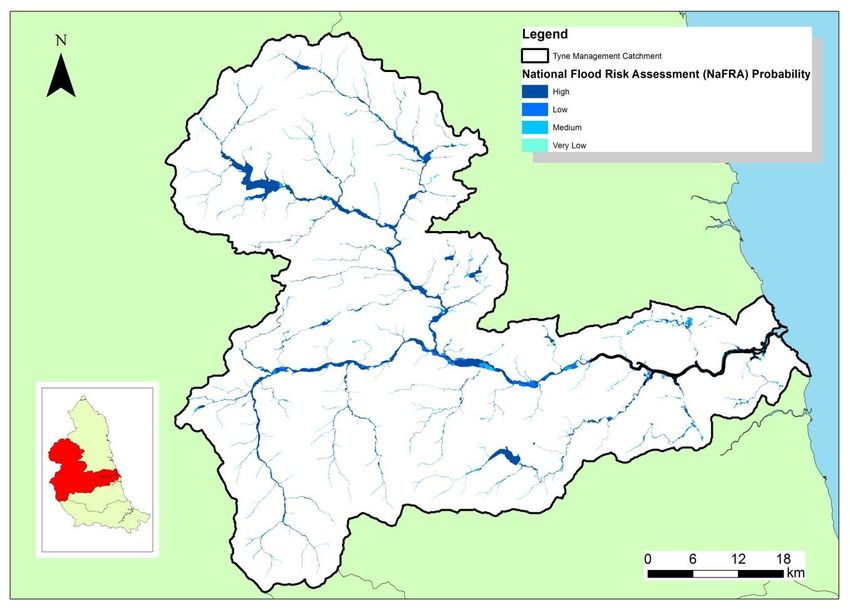
Published by:
Environment Agency                           Further copies of this report are available
Horizon house, Deanery Road,                 from our publications catalogue:
Bristol BS1 5AH                              www.gov.uk/government/publications
Email: enquiries@environment-agency.gov.uk
                                             or our National Customer Contact Centre:
www.gov.uk/environment-agency
                                             T: 03708 506506
                                             Email: enquiries@environment-agency.gov.uk.
© Environment Agency 2016
All rights reserved. This document may be
reproduced with prior permission of the
Environment Agency.

                                                                                           2 of 51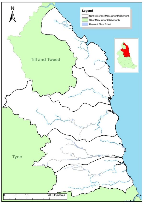
Contents
Glossary and abbreviations ......................................................................................................... 4
The layout of this document ........................................................................................................ 6
1.          Sub-areas in the Northumbria River Basin District ......................................................... 8
     Introduction ................................................................................................................................. 8
     Flood Risk Areas ......................................................................................................................... 9
     Management catchments ............................................................................................................ 9
2     Conclusions, objectives and measures to manage flood risk in Northumbria River
Basin District catchments .......................................................................................................... 10
2.1.        The River Tees Catchment .............................................................................................. 12
     Introduction to the River Tees catchment .................................................................................. 12
     Flood risk maps and statistics.................................................................................................... 15
     Conclusions and objectives for the River Tees catchment ......................................................... 19
     Measures across the River Tees catchment .............................................................................. 20
2.2.        The River Wear Catchment ............................................................................................. 22
     Introduction to the River Wear catchment .................................................................................. 22
     Flood risk maps and statistics.................................................................................................... 24
     Conclusions and objectives for the River Wear catchment ........................................................ 29
     Measures across the River Wear catchment ............................................................................. 30
2.3.        The Tyne Catchment ....................................................................................................... 31
     Introduction to the River Tyne catchment .................................................................................. 31
     Flood risk maps and statistics.................................................................................................... 33
     Conclusions and objectives for the River Tyne catchment ......................................................... 38
     Measures across the River Tyne catchment .............................................................................. 39
2.4.        The Northumberland Rivers Catchment ........................................................................ 40
     Introduction to the Northumberland rivers catchment ................................................................ 40
     Flood risk maps and statistics.................................................................................................... 42
     Conclusions and objectives for the Northumberland rivers catchment ....................................... 48
     Measures to across the Northumbrian rivers catchment ............................................................ 50

                                                                                                                                          3 of 51
Glossary and abbreviations
AONB               Area of Outstanding Natural Beauty
Catchment          The watershed of a surface water river system
CaBA               Catchment based approach: an approach to environmental planning that
                   focuses on local engagement and partnerships
CFMP               Catchment Flood Management Plan
Coastal Groups     Voluntary coastal defence groups made up of maritime district authorities and
                   other bodies with coastal defence responsibilities.
Cross Border       Set up under The Flood Risk (Cross Border Areas) Regulations 2012 (SI No.
Advisory Group     1102). A statutory group made up of representatives from SEPA, Environment
(CBAG)             Agency and local authorities within the cross border areas.
DCLG               Department for Communities and Local Government
Defra              Department for Environment, Food and Rural Affairs
EIA                Environmental Impact Assessment
EPR                Environmental Protection Regulations
EU                 European Union
FCERM              Flood and coastal erosion risk management
Floods Directive   The European Floods Directive (2007/60/EC) on the assessment and
                   management of flood risks.
Flood Risk Area    Areas where the risk of flooding from local flood risks is significant as
(FRA)              designated under the Flood Risk Regulations.
Fluvial            A term used to refer to the processes associated with rivers and streams
FRM                Flood Risk Management
FRMP               Flood Risk Management Plan – plan produced to deliver the requirements of
                   the Flood Risk Regulations.
Government         The term government is used within this report to refer to Defra (the
                   Department for Environment, Flood and Rural Affairs) and Welsh Government.
Groundwater        Occurs when water levels in the ground rise above the natural surface. Low-
flooding           lying areas underlain by permeable strata are particularly susceptible.
Ha                 Hectares
HLS                Higher Level (Environmental) Stewardship
HRA                Habitats Regulations Assessment: an assessment undertaken in relation to a
                   site designated under the Habitats and Birds Directives
Km                 Kilometres
LDF                Local Development Framework
LLFA               Lead Local Flood Authority
Local FRM          Local flood risk management strategy produced by LLFAs under the Flood and
Strategy           Water Management Act 2010.
Main river         A watercourse shown as such on the main river map, and for which the
                   Environment Agency and Natural Resources Wales has responsibilities and
                   powers
MSFW               Making Space for Water
National FCERM     National flood and coastal erosion risk management strategy: these are
                   strategies prepared under the Flood and Water Management Act 2010, by the

                                                                                                   4 of 51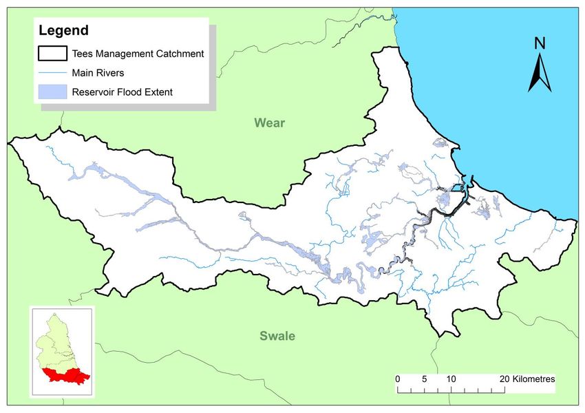
Strategy                 Environment Agency for England and by Welsh Government for Wales.
NNR                      National Nature Reserve
Ordinary                 All watercourses that are not designated Main River, and which are the
watercourses (OW)        responsibility of Local Authorities or, where they exist, Internal Drainage
                         Boards.
PFRA                     Preliminary Flood Risk Assessment – these were required to be published by
                         December 2011 and were the first stage in delivering the Regulations.
PU                       Policy Unit
Ramsar                   Wetlands of international importance designated under the Ramsar Convention
Reservoir                A natural or artificial lake where water is collected and stored until needed.
                         Reservoirs can be used for irrigation, recreation, providing water supply for
                         municipal needs, hydroelectric power or controlling water flow.
Risk management          Organisations that have a key role in flood and coastal erosion risk
authorities (RMAs)       management as defined by the Act. These are the Environment Agency,
                         Natural Resources Wales, lead local flood authorities, district councils where
                         there is no unitary authority, internal drainage boards, water companies, and
                         highways authorities.
RFCCs                    Regional Flood and Coastal Committees
River Basin District     These are the reporting units to the European Commission for the Water
(river basin district)   Framework Directive and the Floods Directive.
RBMP                     River Basin Management Plan – plan required by the European Water
                         Framework Directive.
Riparian owner           Owner of land adjoining, above or with a watercourse running through it.
River flooding           Occurs when water levels in a channel overwhelms the capacity of the
                         channel.
SAC                      Special Area of Conservation
SAM                      Scheduled Ancient Monument
SAMP                     System Asset Management Plan
SEA                      Strategic Environmental Assessment
SFRA                     Strategic Flood Risk Assessment
SMP                      Shoreline Management Plan
SPA                      Special Protection Area
SSSI                     Site of Special Scientific Interest
SuDS                     Sustainable Drainage Systems
Surface water            Flooding from rainwater (including snow and other precipitation) which has not
flooding                 entered a watercourse, drainage system or public sewer.
SWMP                     Surface Water Management Plan
UKCIP                    United Kingdom Climate Impact Projections

                                                                                                          5 of 51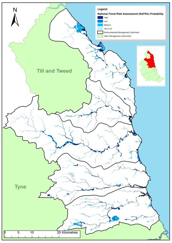
The layout of this document
Flood Risk Management Plans have been divided into four sections to help readers identify and
access information relevant to them. This is Part B. We have divided the plan into four parts:
Section       Name                                          Audience
1             Summary Document                              For those who a high level overview of the
                                                            plan

2             Part A: Background and river basin district   For those who need some legislative
              wide information                              background and river basin district wide,
                                                            high level information
3             Part B: Catchment Summaries                   For those who want the detail of the sub-
                                                            areas and flooding statistics. This section
                                                            includes the catchments based on Water
                                                            Framework Directive (WFD) management
                                                            catchments, Flood Risk Areas (identified
                                                            through the Preliminary Flood Risk
                                                            Assessment) and other strategic areas
                                                            across the river basin district.
4             Part C: Appendices                            For those who want to see the detailed
                                                            program of work for individual communities

Part B of the FRMP documents nationally introduces each of the sub-areas in turn. This section
outlines the catchments based on Water Framework Directive (WFD) management catchments,
which make up the river basin district, then the Flood Risk Areas (identified through the Preliminary
Flood Risk Assessment) and other strategic areas across the river basin district. However, there
were no Flood Risk areas or other strategic areas identified within the Northumbria RBMP and as
such we will be looking at the management catchments only in this document.
The other parts of the flood risk management plan are located on gov.uk
(https://www.gov.uk/government/publications/ northumbria-river-basin-district-flood-risk-
management-plan)

                                                                                              6 of 51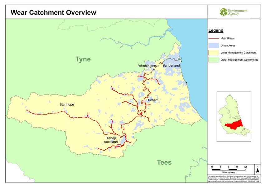
During December 2015, Storms Desmond, Eva and Frank brought record breaking levels of rainfall
and significant flooding to some parts of the country. On 5 and 6 December the highest ever river
flows were registered in several large catchments including the Eden, Lune and Tyne. On 25 and
26 December further record river levels were registered for many large rivers draining the
Pennines. The Met Office confirmed that December 2015 was the wettest on record in parts of the
UK, including Cumbria which experienced more than two and a half times expected monthly
rainfall.
Across the country over 19,000 homes were flooded, with thousands more affected by loss of
power supply and travel disruption. Existing flood defences played an essential part in protecting
thousands of homes during December with 12,500 benefitting during Storm Desmond and 10,900
during Storm Eva. Support to affected communities, business and the agricultural sector is in
place, along with a programme of inspections and repairs to damaged defences.
It is essential to ensure that we have the very best possible plans in place for flood management
across the whole country. In response to the December floods the Government has put in place a
National Flood Resilience Review to identify any gaps in our approach and pinpoint where our
defences and modelling need strengthening. The Local Flood Partnerships in Cumbria and
Yorkshire, set up in response to the December floods will bring together a wide range of
organisations and communities to develop Flood Action Plans. These actions will complement the
measures in the FRMP and the learning from this approach will be shared across the North West
and more widely.
The following flood risk areas and catchments were impacted by the December 2015 storms and
experienced significant flooding to homes, businesses and infrastructure:
Tyne
Wear
Northumberland
7 of 51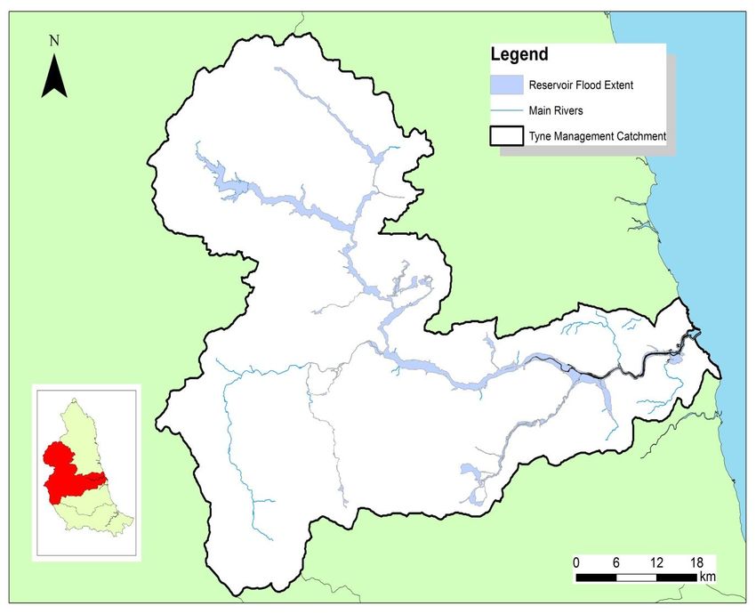
1. Sub-areas in the
Northumbria River Basin
District
Introduction
Within the legislative framework for Flood Risk Management plans, a plan was required for a
number of defined areas. These are:
Catchments (which are set out according to WFD Management Catchments)
Flood Risk Areas (identified in the Preliminary Flood Risk Assessment): areas that require
flood risk management plans for local sources of flooding.
Figure 1: Northumbria River Basin District showing Management Catchments.
8 of 51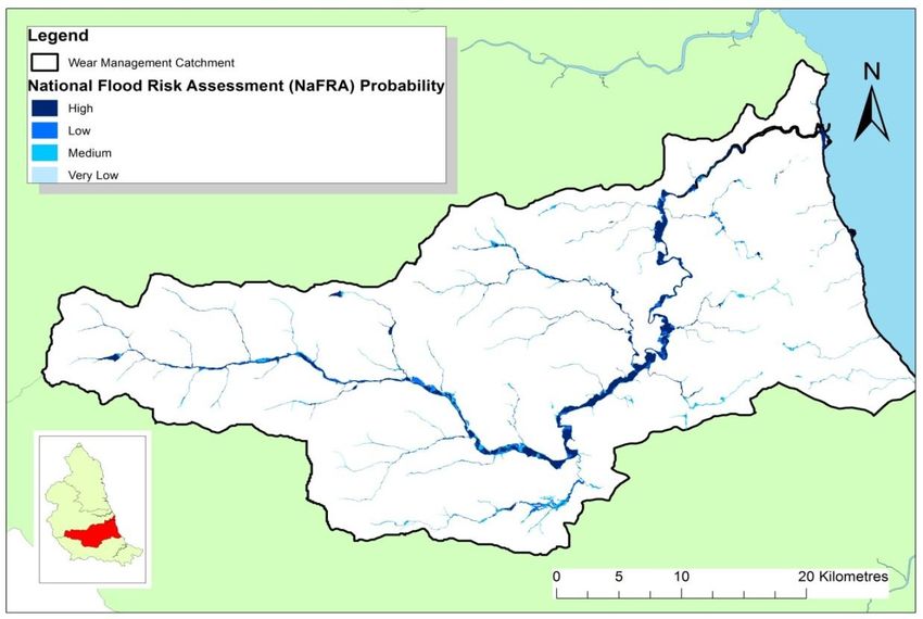
Flood Risk Areas
The Flood Risk Management plans were required for Flood Risk Areas. Significant Flood Risk
areas as defined by the national guidance were identified through the Preliminary Flood Risk
Assessment process. There were no Flood Risk Areas identified within the Northumbria River
Basin District during the Preliminary Flood Risk Assessment process, as defined by the national
guidelines. The lead local flood authorities have used the output from the process to feed into their
ongoing Local Flood Risk Management Strategies.
Management catchments
There are 4 catchments within the Northumbria River Basin District, as shown in Figure 1 and
outlined below. These are areas where we focus engagement to enable a catchment based
approach to water management.
These are the same as the Water Framework Directive management catchments and are:
Tees
Wear
Tyne
Northumberland Rivers – this includes the rivers north of the River Tyne and includes the
River Blyth, Wansbeck, Coquet, Aln and a number of the coastal streams draining to the
north east coast. It does not include the Tweed and English tributaries of the Tweed which
are in the separate Solway Tweed River Basin District
As the Flood Risk Management Planning process continues over the years it is likely that these
broad catchment areas will be further divided to allow measure to be further focused on
operational areas and / or communities.
9 of 51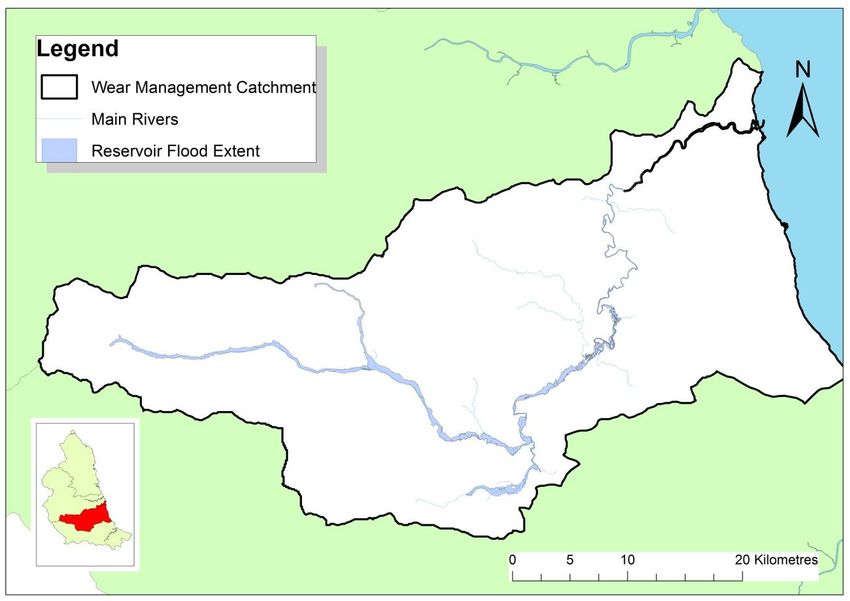
2 Conclusions, objectives and
    measures to manage flood risk in
    Northumbria River Basin District
    catchments
The following sections consider the measures for each of the following catchments in the
Northumbria river basin district:

       Tees
       Wear
       Tyne
       Northumberland

Each section considers an individual catchment and gives a brief description and outline of the
catchment and the flood risk within the catchment along with an outline of the measures which are
in place to manage flood risk going forward.
As this plan considers the flood risk from the main rivers, reservoirs and the sea, there may be
additional useful flood risk information available on the relevant council websites. Table 1 below
shows the council and the river catchments which fall into their respective areas. It also has a link
to either their website, flood risk management page or to their local strategy if that is currently
available on line. In order to get a more complete picture of flood risk in an area it is encouraged
that these councils are contacted.

                                                                                             10 of 51
LLFA Relevant management Link to further information
catchment
North Yorkshire County • Tees North Yorkshire County Council
Council Local Flood Risk Strategy
Redcar and Cleveland • Tees Redcar and Cleveland Council
Website
Middlesbrough • Tees Middlesbrough Local Flood Risk
Management Strategy
Stockton • Tees Stockton Council Website
Hartlepool • Tees Hartlepool Council Website
Darlington • Tees Darlington Council Website
Durham County Council • Tees Durham County Council Flood Risk
• Wear Website
• Tyne
Sunderland City Council • Wear Sunderland City Website
• Tyne
South Tyneside Council • Tyne South Tyneside Flood Risk
Management Pages
Gateshead Council • Tyne Gateshead Council Website
North Tyneside Council • Tyne North Tyneside Council Local Flood
• Northumberland Risk Strategy
Newcastle • Tyne Newcastle City Council - Flood
Management Team
Northumberland • Tyne Northumberland County Council Flood
• Northumberland Risk Management
Cumbria County Council • Tyne Cumbria County Council Flood Risk
Management Pages
Table 1- Lead Local Flood Authorities and links to more information
11 of 512.1. The River Tees
Catchment
Introduction to the River Tees catchment
The River Tees, as shown in Figure 2 is a predominately rural catchment located in the North East
of England containing the urban areas of Darlington, Stockton on Tees, Hartlepool and
Middlesbrough. The Tees drains the eastern slopes of Cross Fell in the Pennines and flows
eastward to the North Sea. The length of the channel from source to sea is approximately 160
kilometres. The catchment has areas with distinctly different characteristics. The rivers in the
Upper Tees have steep channel gradients and valley sides. In the mid-catchment, the valley
widens out and channel slopes become much gentler. The lower catchment is close to sea level
and predominantly tidal in nature.
The river networks of this catchment drain water falling onto the catchment by discharging into the
North Sea at Tees Mouth, south of Hartlepool. River or fluvial flooding is mainly from the River
Tees, River Skerne, River Leven and Lustrum Beck with the settlements of Croft, Neasham, Yarm,
Darlington, Stokesley and Stockton on Tees particularly at risk. Fluvial flooding also occurs in
Guisborough, Loftus and Skinningrove from the coastal streams of the Chapel Beck and
Kilton/Whitecliffe Beck. Tidal flooding in the Tees Estuary can result in flooding of low lying areas.
Particular areas of concern are Port Clarence and the heavily industrialised areas around Tees
Mouth. Concurrent high fluvial flows can exacerbate flooding in the tide locked streams such as
Lustrum Beck, Billingham Beck and the Middlesbrough Becks.
Figure 2. Overview of the Tees catchment
12 of 51Land Use and Management
The entire Tees management catchment is approximately 1,955 km2 in area and a large proportion
is rural and therefore managed, directly or indirectly, for agriculture, forestry, tourism or
conservation. The total population of the catchment area is approximately 687,000 people. The
western part of the catchment consists of Pennine uplands and sparsely populated rural valleys
with small villages and towns, including Middleton-in-Teesdale and Barnard Castle. In contrast,
areas adjoining the tidal reach of the river are densely populated and include the major towns of
Stockton-on-Tees, Middlesbrough, Hartlepool and Billingham with a tradition of heavy industry
including chemicals, steelmaking, oil refining and storage.
The east of the catchment is relatively heavily urbanised, with the larger settlements of Hartlepool,
Stockton-on-Tees, Darlington and Middlesbrough (although the urban areas only amount to 11% of
the whole catchment). Rainwater will run off these impermeable urban surfaces at a higher rate
than in rural areas, resulting in a rapid rise in river level and higher flood levels. The catchment is
rich in its environmental and landscape value, containing a large number of key environmental
sites located primarily in the Tees Headwaters.
The Skelton and Kilton Beck sub catchment covers an additional area of 145km2. The sub
catchment is predominantly rural with a number of larger settlements located along the river
corridors, most notably the towns of Guisborough, Skinningrove and Saltburn-by-the-Sea. The
major watercourses in this sub catchment are Chapel Beck, which flows through Guisborough and
joins Skelton Beck further downstream, and Kilton Beck, which flows through Loftus and
Skinningrove.
Geology
The geology of the upper Tees catchment consists of impervious bedrock of Carboniferous age,
which is, in turn, composed of alternating limestones, shales, sandstones, thin coal seams and
Millstone Grit. This has an effect on rainfall runoff by creating an impermeable layer below the
upland soils. Coal Measures are exposed over a comparatively small part of the middle catchment
but underlie the Magnesian Limestone towards the Durham coast. The lower Tees, including the
estuary and the lower Leven, is mainly underlain by Keuper and Bunter marls and sandstones of
Triassic age which dip gently towards the southeast. Glaciation has created an undulating
landscape over most of the lowlands and, in these areas, the bedrock is rarely exposed.
The Skerne catchment is predominantly underlain by permeable Magnesian Limestone of Permian
age with a variable cover of boulder clay of low permeability. Coal Measures occur below the
Magnesian Limestone in the Skerne catchment at a progressively greater depth towards the coast.
Deep mining has been carried out in the northwest of the catchment in the concealed coalfield at
Thrislington and Mainsforth. Both mines shut down in the late 1960s. Sandstones, shales and
ironstones of the Lias Group of Jurassic age are exposed in the Cleveland Hills in the Upper Leven
and neighbouring catchments. In the past, iron ore was extensively mined in this catchment.
Triassic sandstones and marls underlying the lower reaches are generally concealed by glacial
drift and alluvium.
The major aquifers within the Tees catchment are the Magnesian Limestone and the Keuper and
Bunter Sandstones. The Magnesian Limestone is extensively used for water supply, especially by
Hartlepool Water for whom groundwater sources form the greater part of their resources. Water
table levels intersect the ground surface in valley floors, within river channels and at defined
springs and provide dry weather flows in river channels.
Drift material covers the solid bedrock throughout the catchment and has an important role in
governing runoff and groundwater. As can be seen much of the catchment is covered by deposits
of peat and glacial till. This till is of low permeability, as is the peat, which helps to promote rapid
runoff from the land from rainfall. The Tees floodplain contains thick deposits of coarse gravels and
sands laid down by retreating ice sheets. Gravels and sands can also be found in the estuarine
area. There are also notable proportions of clay, silt and sand along the River Leven.
13 of 51National and International Designations
The Tees Catchment has a high conservation value and contains a large number of designated
environmental sites covering a wide range of natural, archaeological and heritage sites. The upper
part of the catchment is almost entirely within the North Pennines of Natural Outstanding Beauty
(AONB). 56 Sites of Special Scientific Interest (SSSI), 5 Special Area of Conservation (SAC) and 3
Special Protection Areas (SPA) can be found in the headwaters and throughout the catchment.
Partnership Working
Within the Tees Catchment we have developed a good working relationship with our partners.
There are large number of Lead Local Flood Authorities within the catchment including Durham
County Council, Stockton Borough Council, Darlington Borough Council, Middlesbrough Council,
Hartlepool Borough Council, Richmondshire Borough Council, Hambleton District Council, North
Yorkshire County Council and Redcar and Cleveland Borough Council. There are no Internal
Drainage Boards within the Tees Catchment. We work closely with the Lead Local Flood
Authorities to help them develop their programme of capital works for flood risk management. We
are committed to working with all of these Lead Local Flood Authorities in assisting with the
preparation of their LFRMS and also to minimise the impact of new developments on flood risk.
We actively seek to work in partnership with the Lead Local Flood Authorities and other risk
management authorities (e.g. Northumbrian Water Ltd) in order to achieve the common goal of
reducing flood risk from all sources. For example, we are currently working in partnership with
Stockton BC on a flood alleviation scheme to reduce flood risk from the Lustrum Beck. We will also
be consulting upstream landowners regarding the potential to use Natural Flood Management
techniques. We strive to maintain close links with landowners, environmental organisations (e.g.
RSPB, Natural England) and the many commercial industries on Teesside. For instance, the
Greatham South/Port Clarence FAS is a current project involving many such partners, including
nearby environmental organisations and local industries.
All of our flood risk measures, proposals and partnership schemes aim to liaise closely with
affected communities and landowners to ensure the best possible outcome for all.
14 of 51Flood risk maps and statistics
Flooding from Rivers and the Sea
River or fluvial flooding mainly from the River Tees, River Skerne, River Leven and Lustrum Beck
with the settlements of Croft, Neasham, Yarm, Darlington, Stokesley and Stockton on Tees
particularly at risk. Fluvial flooding also occurs in Guisborough, Loftus and Skinningrove from the
coastal streams of the Chapel Beck and Kilton/Whitecliffe Beck.
Tidal flooding in the Tees Estuary can result in flooding of low lying areas. Particular areas of
concern are Port Clarence and the heavily industrialised areas around Tees Mouth. There is also
potential for some defences to fail, notably those at Port Clarence, Old River Tees and at
Greatham Creek. This was demonstrated during the tidal surge that affected the East Coast in
December 2013. Concurrent high fluvial flows can exacerbate flooding in the tide locked streams
such as Lustrum Beck, Billingham Beck and the Middlesbrough Becks.
Over 20,000 people are at risk of flooding from Rivers and the Sea in the Tees catchment,
representing approx 2.5% of the total population within the catchment. Over 4,000 non residential
properties are also considered to be at risk. Approximately 5.5% of the agricultural land within the
catchment is at risk of flooding from Reservoirs. Approximately 3.3% of SSSI sites and 74% of
Ramsar sites are at risk of flooding in the area.
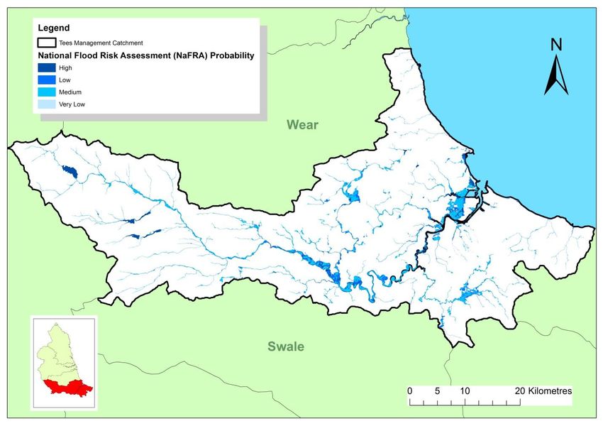
Fig.3 National Flood Risk Assessment (NAFRA) in the Tees catchment
15 of 51Table. 2. Summary of flood risk from rivers and sea to people, economic activity and the
natural and historic environment across the Tees Catchment.
River and Sea Total in High risk Medium Low risk Very low
river risk risk
basin
district
Risk to people:
Number of people in area: 811,550 1,700 7,450 11,200Flooding from Reservoirs
There are six large water supply reservoirs with a combined catchment area of 181km2. The
majority of these are in the western part of the catchment, which is also the wettest part. Total
reservoir capacity is 88 million litres, of which nearly half is stored in the largest reservoir at Cow
Green used entirely for river regulation. Whilst reservoir releases and abstractions have a major
impact on low flows, their effect on flood discharges is limited. However, reservoir construction and
operation has significantly reduced downstream flood risk. Flood flows are reduced as a result of
reservoir storage, which includes a reserve capacity that must be filled before spill occurs. It is
likely that the extensive reservoir development in the upper Tees will have altered the natural flood
regime not only at the dam site but for the entire length of the river in terms of peak flows and flood
volumes.
Over 23,000 people live in properties within the Reservoir Map flood extent in the Tees catchment
- equating to around 2.8% of the population. Based on these indicative maps, there are also
approximately 4,000 non residential properties (5.4%) and 6000Ha of agricultural land (5.5%)
within the flood extents.
Fig.4 Reservoir Flood Risk Extents in the Tees Catchment
17 of 51Table. 3. Summary of flood risk from reservoirs to people, economic activity and the natural
and historic environment across the Tees Catchment.
Reservoirs Total in river Maximum
basin district extent of
flooding
Risk to people:
Number of people in area: 811,550 23,200
Number of services: 1,370 100
Risk to economic activity:
Number of non-residential properties: 75,050 4,050
Number of airports: 1 0
Length of roads (km): 480 30
Length of railway (km): 170Other Sources of Flooding
Surface water and sewer flooding affect parts of the catchment when intense thunderstorms in
urban areas overwhelm the drainage network. This is a particular problem in Darlington where one
of the main risks is from surface water being unable to discharge to drains and rivers. There are
also similar problems with surface water in Hartlepool, Guisborough, Stockton on Tees, Eston and
near Teesside Retail Park. There are known problems with the sewerage system in Yarm and at
High Tunstall. The sewer problems on Acklam Road, Middlesbrough lead to flooding through
drainage overload. This can be exacerbated by high flows in the Old River Tees.
It is suspected that groundwater flooding occurs regularly in the north east of the catchment
(particularly in the Skerne catchment), but since the events often result in surface water flooding,
they are recorded as such in the records. Although groundwater levels in the Skerne catchment
are continuing to rise as a result of mine water rebound, the geology in the Tees catchment means
that groundwater is unlikely to be a major problem.
Conclusions and objectives for the River Tees catchment
Conclusions
Although the population is relatively small for the land area covered by the large Tees catchment,
flooding could affect 3% of the total catchment population (based on 1% AEP event). Whilst this
may not seem a high figure, it does represent over 8,000 residential properties that are at risk of
flooding from the rivers.
The risk of flooding varies through the catchment with the changing character of the landscape and
land use. Although there is a rapid, high volume of runoff from the upper part of the Tees, there are
a low number of properties at risk of flooding. The rural nature of the catchment means that
properties are often isolated and away from urban centres. This makes it a challenge to provide
protection to all properties at risk in terms of cost beneficial solutions. There is little natural
floodplain storage in the upper catchment to slow the flow of floodwaters to lower reaches. In the
Middle Tees the area of natural floodplain increases. Flood waters flow into these large floodplain
areas, which helps to reduce flows to downstream areas. The main risk areas in the Lower Tees
are around Middlesbrough and Stockton. Problems in this area are exacerbated both by high tides
and by the series of urban rivers that drain into the Tees Estuary.
Other sources of flooding from reservoirs, surface water, ordinary watercourses, ground water and
sewers are also significant throughout this catchment. There have been many reported incidents in
recent years of these types of problems affecting householders and businesses. The updated
surface water flood maps (December 2013) show a widespread problem.
Whilst the area has some challenging flooding problems to address, the amount of undeveloped
land available in the catchment means that there is the space to adopt new techniques and
practices such as Natural Flood Management to alleviate these problems. Close liaison with
landowners will be of key importance in the effectiveness of this method of alleviating flood risk
and they are currently being investigated as part of the Lustrum Beck and Guisborough schemes.
19 of 51Objectives
Our objectives when preparing this flood risk management plan have been as follows:
Social
Reduce the number of people exposed to each category of flood hazard particularly high
and extreme hazard
Ensure that critical infrastructure remains operational during flood events
Reduce the social impact of flooding on communities at risk, especially in areas where
there are high proportions of properties and social assets at risk
Economic
Reduce the direct economic damages to property and agriculture from flooding
Ensure that FRM expenditure follows the level of flood risk in the catchment
Environmental
Protect heritage sites from the effects of flooding and where possible use FRM activities to
enhance the landscape
Maintain and where possible improve the ecological function of designated sites through
FRM activities
Allow river channel processes to operate naturally within the catchment.
No adverse impact on water quality as a result of flooding.
Measures across the River Tees catchment
Across the Tees Catchment there are 58 measures that have been identified to manage flood risk.
These are summarised below.
Preventing risk: 15 measures
Undertake an assessment to identify culverts which may be removed to reduce flood risk in
the West Beck area and Lower Tees
Review the land drainage pumping regimes around Mainsforth Stell, Morden Carrs and
Seamer Carr and develop a long term pumping strategy where appropriate
Seek opportunities to provide additional flood plain storage upstream of Croft, Darlington
and Billingham.
Undertake assessment of surface water flood risk throughout North Yorkshire area.
Carry out assessment of flood risk at historic parks and buildings and investigate
opportunities to prevent flooding impacting the fabric of the area, includes Lartington and
Rokeby Parks
Develop an operational catchment plan for North Yorkshire County Council to maximise
effectiveness of flood risk management funds
20 of 51 Develop a Flood Risk Management Tool Kit of useful information and advice to support
communities in managing flood risk
Seek opportunities to restore Peat Bogs to reduce flood risk on the Lower Tees areas
Preparing for risk: 28 measures
Assessing Flood Risk to infrastructure and developing emergency plans for them to ensure
that they are resilient to flood risk, across all the catchment (7 measures)
Establishing and maintaining a register for flood risk assets to ensure that they are
identified and maintained across all Lead Local Flood Authorities areas (7 Measures)
Develop and maintain local and multi agency flood plans to ensure areas are prepared for
flooding across LLFA areas (7 measures).
Develop Rapid Response Catchment Action Plans for the Middlesbrough Becks to inform
communities and prepare emergency plans
Investigate groundwater flooding and where possible develop flood warning procedures for
areas within North Yorkshire County Council area
Protecting from risk: 12 measures
Develop flood protection schemes at Lustrum Beck and Port Clarence.
Improve flood plain usage in the upper catchments reducing flood flows in the lower
catchments throughout the Tees, Skerne and Greatham by assessing redundant flood
banks.
Develop where justified a flood bank refurbishment scheme for the Oxney Flatts area
Investigate and develop flood protection schemes where funding can be secured for areas
around Stokesley, Guisborough and Staindrop
Recovery and review of risk: 3 measure
Around reviewing flooding to identify assets implicated in impacting on flooding and
develop strategy to manage those assets across North Yorkshire County Council area.
21 of 512.2. The River Wear
Catchment
Introduction to the River Wear catchment
The Wear catchment is found in the North East of England. The Wear rises in the North Pennine
Moors with the area draining between Killhope Law and Burnhope Seat.
The Wear catchment has distinctly different landscapes within it. The upper part of the catchment
is almost entirely within the North Pennines, characterised by upland heather and peat moors,
steep sided valleys and narrow valley bottoms and small market towns. As the river descends
through the catchment it passes through a more agricultural landscape of wider valleys and more
open floodplains.
The many streams draining this area eventually come together to form the start of the River Wear
at Wearhead in County Durham. Two other major rivers in the North East of England rise in the
Pennines with 20 miles of the Wear. These are the Tees and the Tyne, which border the Wear to
the South and North respectively. The Wear catchment includes the Rivers Gaunless, Deerness
and Browney as its major tributaries. The catchment area also includes a number of small Coastal
Streams that are not connected hydrologically to the River Wear. The major streams are Castle
Eden Burn, Thorpe Burn and Seaton Burn.
Figure 5 Overview of the Wear Catchment
22 of 51Land Use and Population
The entire Wear management catchment is approximately 1,080 sq km in area and a large
proportion is rural and therefore managed, directly or indirectly, for agriculture, forestry, tourism or
conservation.
More than 650,000 people live within the catchment area. Apart from the small market towns in the
upper reaches, the majority of people live in the lower reaches of the catchment where the
landscape becomes more heavily urbanised. Major urban areas of Durham, Chester-le-Street and
Sunderland have built up on the banks of the Wear through the ages. The Wear eventually flows
out to the North Sea through Wearmouth at Sunderland where it meets the boundary of the North
East Coastal Authority group’s shoreline management.
Geology
The underlying geology of the Wear Catchment area is of Carboniferous age. Coal Measures,
Millstone Grit, Upper and Lower Limestone dominate the geology of the upper Wear catchment.
The majority of the uplands of the catchment is underlain by Millstone Grit; whilst this layer is
permeable, it overlies impermeable soils.
Coal Measures and Magnesian Limestone are predominant in the middle and lower reaches and
the Coastal Streams area.
National and International Designations
The Wear catchment has distinctly different landscapes within it. The upper part of the catchment
is almost entirely within the North Pennines AONB. Within the uplands are the North Pennines
Moors and the North Pennines Dales, both of which are designated as important environmental
sites under the Habitats Directive. Numerous Sites of Special Scientific Interest (SSSI) can be
found in the headwaters and throughout the catchment. The Durham Castle and Cathedral World
Heritage Site sits in the catchment.
Partnership Working
Within the Wear Catchment, Risk Management Authorities (RMAs) have developed a good
working relationship. There are two Lead Local Flood Authorities (LLFAs) in the catchment;
Durham County Council and City of Sunderland. There are no Internal Drainage Boards within the
Wear Catchment. We work closely with the LLFAs to help them develop their programme of capital
works for flood risk management. We are committed to working with these LLFAs in assisting with
their LFRMS and to minimise the impact of new developments on flood risk.
In addition to Local Authorities, a number of organisations and individuals have a role to play in
managing flood risk; Highway Authorities, Network Rail, Rivers Trusts, Northumbrian Water. We
strive to maintain close links with landowners, environmental organisations and commercial
businesses within the catchment.
It is essential that all main organisations and decision-makers in the Wear catchment work
together, to plan and take action to reduce any unacceptable flood risk whilst improving the
environment where possible. The purpose of consultation is to guide and help us with issues such
as technical matters, identifying sources of information, completing the communications plan and
agreeing results.
All flood risk measures, proposals and partnership schemes aim to liaise closely with affected
communities and landowners to ensure the best possible outcomes.
23 of 51Flood risk maps and statistics
Flooding from Rivers and the Sea
Figure 6. National Flood Risk Assessment (NAFRA) in the Wear Catchment
River and Sea Flooding
The River Wear has a long and varied flood history with significant events occurring in the 1940s,
1960s, 1990s and most recently in 2000, 2005 and 2015. Due to the differences in the catchments
between the main river Wear and the tributary rivers catchment, wide floods are rare and flooding
generally occurs on either the Wear, or the tributaries, but rarely on both at the same time.
The largest floods on the Wear have historically been associated with winter storms, when milder
weather fronts have resulted in significant volumes of rainfall falling and melting large amounts of
lying snow in the upper catchment. Flooding has occurred in all of the principal settlements along
the Wear including Stanhope, Frosterly and Wolsingham in the upper Weardale areas.
While recent floods have flooded limited areas of Durham City, major flooding did occur in the
1960s flooding areas around the Framwellgate and Elvet riverside and up towards the rugby
grounds and rowing club to the east of the city.
24 of 51Table 4: Summary flood risk from rivers and sea to people, economic activity and the
natural and historic environment across the Wear Catchment.
River and Sea Total in High risk Medium Low risk Very low
river risk risk
basin
district
Risk to people:
Number of people in area: 658,000 700 1,150 4,350There are over 6,000 people at risk of flooding from Rivers and the Sea in the Wear catchment,
representing approximately 1% of the total population within the catchment. Over 1,500 non
residential properties are also considered to be at risk. Approximately 6% of the agricultural land,
1.7 % of SSSI sites and 68% of Ramsar sites are at risk from river/sea flooding in the area.
Flooding from Reservoirs
Non-natural or artificial sources of flooding can include reservoirs, canals and lakes, where water is
retained above natural ground level. Flooding from these sources is most likely to occur as a result
of a catastrophic failure of a retaining structure such as a dam wall. This type of flooding can occur
without any warning, with devastating and often fatal consequences. As control and management
to prevent this type of flooding occurring lies under the Reservoir Act 1975 which the Environment
Agency now enforce, it is not likely that the maximum extent flood would occur in the catchment.
Figure 7 Reservoir Flood Risk in the Wear catchment
26 of 51Table 5. Summary flood risk from reservoirs to people, economic activity and the natural
and historic environment across the Wear catchment.
Reservoirs Total in river Maximum
basin district extent of
flooding
Risk to people:
Number of people in area: 658,000 6,550
Number of services: 1,010 20
Risk to economic activity:
Number of non-residential properties: 48,500 950
Number of airports: 0 0
Length of roads (km): 350Other Sources of Flooding
The main source of flooding in the catchment is from the rivers, there are no known groundwater
flooding problems. Given the large urban areas in the east of the catchment there are some
instances of surface water flooding where intense rainfall can exceed the capacity of the urban
drainage systems.
Coastal Erosion
Shoreline management plans (SMPs) are large-scale assessments of the risks associated with
coastal processes. SMPs provide the basis for policies for a length of coast and set the framework
for managing risk along the coastline in the future. The SMP of relevance to the Wear Catchment
area is the River Tyne to Flamborough Head SMP. The River Tyne to Flamborough Head SMP2
was published in February 2007, and has developed an action plan for works which has been
taken into account in this plan.
28 of 51Conclusions and objectives for the River Wear catchment
Conclusions
More than 650,000 people live within the Catchment, the majority of who are found in the lower
reaches where the landscape becomes more heavily urbanised. Major urban areas of Durham,
Chester-le-Street and Sunderland have built up on the banks of the Wear through the ages. The
Wear eventually flows out to the North Sea through Wearmouth at Sunderland
Whilst the population is large for the catchment there is a small percentage of the population at
high risk from flooding.
Other sources of flooding from reservoirs, surface water, ordinary water courses, ground water and
sewers are significant in this catchment. There have been many reported incidents in recent years
of these types of problems affecting householders and businesses. The updated surface water
flood maps (December 2013) show a widespread problem.
Whilst the area has some challenging flooding problems to address, the amount of undeveloped
land available in the catchment means that there is the space to adopt new techniques and
practices to alleviate these problems.
Objectives
Our objectives when preparing this flood risk management plan have been as follows:
Social
Reduce risk to people
Promote understanding of flood risk
Work in partnership with all of our stakeholders including landowners affected by any of our
assets/work.
Prepare communities and build resilience
Minimise community disruption
Consider flood risk in Development Plans
Maintain existing assets that protect people
River, watercourse and tidal defence maintenance
Economic
Reduce economic damage to property and agriculture from flooding
Maintain existing assets that protect business
Protect transport services
Minimise flood risk to agricultural Land
Protect tourism when undertaking flood risk management
Environmental
Achieve WFD objectives through flood risk management
Protect designated nature conservation sites
Protect designated heritage sites
29 of 51Measures across the River Wear catchment
Across the Wear Catchment there are 26 measures to manage flood risk include. These are
summarised below.
Preventing risk: 6 measures
Seek opportunities to carryout woodland planting in the upper catchments and where
studies have indicated in the floodplain in the Upper Wear and within the Lumley Park Burn
and Browney Catchments to assist in slowing flows and improving flood plain storage
Seek opportunities to raise bridges to reduce flow constrictions on the Beechburn Beck
through settlements such as Crook
Further develop the stand alone flood scheme for Chester le Street in addition to the new
flood defence upstream of the culvert. This could include measures to day light culverts to
improve conveyance through the town
Develop habitat creation opportunities in the tidal River Wear and Coastal Streams which
have a positive impact on flood risk or as opportunities for compensatory habitat for other
schemes
Avoid inappropriate development in the flood plain, maintaining watercourses, managed
realignment of defences and improving our understanding of all sources of flooding to
inform future flood risk management.
Preparing for risk: 8 measures
Assessing Flood Risk to infrastructure and developing emergency plans for them to ensure
that they are resilient to flood risk, across all the catchment
Establishing and maintaining a register for flood risk assets to ensure that they are
identified and maintained across the whole catchment.
Carry out a Flood Warning Improvement Study in order to improve the existing flood
warning process across the tidal River Wear and in Lanchester
Protecting from risk: 12 measures
Undertake and assessment of agricultural assets to determine if abandonment or reduced
maintenance is justified, defences to be assessed include those around Chester Le Street,
Houghall, Witton le Wear, Old Durham Beck, Browney and the Gaunless (4 Measures)
Following assessment of defences look for opportunities to work in partnership to create
habitat improvements and recreate natural flood plain in areas identified in assessment (3
Measures)
Carry out a strategic assessment of flood storage upstream of Durham and Lanchester to
maximise flood plain usage to reduce flood risk in target communities
Investigate and develop flood protection schemes for Tindale Beck
Carry out coastal flooding study around Seaburn to identify opportunities to reduce risk
Recovery and review of risk:
There are no measures over and above our existing flood risk work.
30 of 512.3. The Tyne Catchment
Introduction to the River Tyne catchment
The River Tyne is generally a rural catchment with an agricultural based landscape in the
west and the cities of Newcastle and Gateshead located in the eastern portion of the area.
The headwaters drain remote moorland and flow through narrow, steep valleys. Within the
upland area of the North Tyne, Rede and Derwent there are a number of regionally
important water supply reservoirs including Kielder and Derwent Reservoirs. These
reservoirs can affect flood flows and are also able to maintain river flows in the Tyne, Wear
and Tees rivers via water transfer infrastructure. The middle catchment contains fertile
agricultural plains with a string of towns along the watercourses. The lower sections of the
catchment are more urban and include the Newcastle and Gateshead areas. The River Tyne
flows into the North Sea and is tidally influenced from Wylam to the coast.
Figure 8 Overview of the River Tyne Catchment
The River Tyne catchment includes the main river systems of the North and South Tyne,
Tyne, Rede, Allen, Team, Derwent, Ouseburn and Don. There are many ordinary
watercourses which feed into these main rivers. Much of the western area of the catchment
is dominated by narrow, steep side valleys. The high catchment relief produces steep river
gradients of between 1% and 10% within the river Tyne’s headwaters and 0.1% towards its
tidal reaches. With the exception of the upper reaches of the Ouseburn, all major tributaries
have similarly steep river gradients.
31 of 51Land Use and Management
The Tyne catchment is approximately 2,926 km2 in area and predominantly rural, the main
urban areas being in the east of the catchment namely Newcastle and Gateshead. The total
population in the catchment area is approximately 1,039,360 people. Urban land-use
occupies around 7.3% of the catchment area. Urban areas within the catchment include the
city of Newcastle, Gateshead, North Tyneside and South Tyneside. As well as these larger
areas, there are a number of smaller towns. These include, Hexham, Corbridge, Haltwhistle,
Alston and Bellingham. Surface water flooding can cause problems in all these urban areas.
The heavily urbanised catchments are the Ouseburn, Team and Don.
Geology
Rocks from the carboniferous period lie entirely under the Tyne area. This carboniferous
strata dips eastwards, with the oldest rocks located in the northwest in the River North Tyne
sub-catchment. These rocks are of the Wenlock, basalt and carboniferous limestone series.
The majority of the South Tyne sub-catchment is dominated by carboniferous limestone and
millstone grit, whilst coal measures outcrop into the Lower Tyne and Derwent catchments.
The influence of geology on flooding within the River Tyne is reduced by the large extent and
low permeability of overlying drift material. However, some small areas of exposed rock
occur on higher ground. Areas of millstone grit within the River South Tyne catchment
encourage surface runoff, whilst there is less runoff from the more permeable carboniferous
limestone within the River North Tyne catchment. This means that the River South Tyne
responds to rainfall more and quicker compared to the River North Tyne.
National and International Designations
Much of the upland catchment lies within the North Pennine Area of Outstanding Natural
Beauty (AONB). In addition there are eighty seven Sites of Special Scientific Interest (SSSI),
as well as all or part of nine Special Areas of Conservation (SAC) and two Special Protection
Areas (SPA) within the catchment. There is a rich cultural heritage, including 530 Scheduled
Ancient Monuments (SAM), part of the Hadrian’s Wall World Heritage Site, 14 Registered
Parks and Gardens and two Registered Historic Battlefields.
Partnership Working
Within the Tyne Catchment we have developed a good working relationship with our
partners. The majority of the catchment falls within the lead local flood authority (LLFA)
boundary of Northumberland County Council. Parts of the upper reaches of the River South
Tyne fall within the Eden District Council area and Upper reaches of the River Derwent fall
under Durham County Council. The more heavily urbanised area of the catchment in the
east is split between four Lead Local Flood Authorities – Gateshead Metropolitan Borough
Council, Newcastle City Council, North Tyneside Council and South Tyneside Council. They
published their Local Flood Risk Management Strategy (LFRMS) in 2012, and are working
with us to prepare an updated version in the light of the new flood hazard mapping and other
new data. Northumbria Water Limited is a risk management authority dealing with the sewer
network for the whole of the North East of England. Strategic partnerships have been
established between risk management authorities of which there are two for the Tyne
Catchment – Northumberland Strategic Partnership and Tyne and Wear Strategic
Partnership. All of our flood risk measures, proposals and partnership schemes aim to liaise
closely with affected communities and landowners to ensure the best possible outcome for
all.
32 of 51Flood risk maps and statistics
Flooding from Rivers and the Sea
The topography and prevailing climate of the Tyne headwaters combine to produce floods
which travel downstream very quickly, in comparison to other rivers of similar size. Flood
peaks travel the 40 km between Alston and Haydon Bridge on the South Tyne in about three
hours (average speed 13 km/h), and between Kielder dam and Bellingham on the North
Tyne (17 km) in about 3.5 hours (average speed 5 km/h). On the North Tyne tributary, the
Rede, floods move at an average speed of 9 km/h. Below the North Tyne/South Tyne
confluence, flood peaks slow to around 8 km/h at Bywell, as the gradient lessens and the
river widens. Generally the North Tyne responds after the peak in the South Tyne has
passed the confluence, so that the hydrograph at Bywell has a long falling limb, but does not
represent the combined peak flow in both tributaries.
Figure 9 Flood Risk in the River Tyne catchment
The extent and depth of flooding within the tidal reaches of the catchment have been
obtained from flood zone 2 maps and a previous detailed modelling study. The upstream
extent of tidal flood risk is at Wylam on the River Tyne and at locations on the lower reaches
of adjoining tributaries such as the Derwent, Team, Ouseburn and Don. Tidal lag times
between the river mouth at North Shields and flood risk areas upstream are very short (less
than five minutes at Newcastle bridges, a distance of 16 km), and demonstrate the speed of
tidal inflow along the River Tyne.
Table.6. Summary flood risk from rivers and sea to people, economic activity and the
natural and historic environment across the Tyne catchment.
33 of 51River and Sea Total in High Medium Low risk Very low
river risk risk risk
basin
district
Risk to people:
Number of people in area: 1,039,500 1,100 1,600 3,700Flooding from Reservoirs
The location of reservoirs in the upper reaches of the North Tyne and Derwent river
catchments represents a very small flood risk to areas downstream. Whilst failure of the
dams could have a devastating effect due to the volume of water and the speed of flooding,
the chance of this happening is very small given the standards of engineering and design
used when building the dams.
Over 23,400 people live in properties within the Reservoir Map flood extent in the Tyne
catchment - equating to around 2.3% of the population. Based on these indicative maps,
there are also approximately 7,200 non residential properties (10.7%) and 5900 Ha of
agricultural land (9.8%) within the flood extents.
Other Sources of Flooding
Surface water and sewer flooding affect the catchment. Previous Phase 1 flood risk mapping
studies have shown that the blockage of culverts and bridges is a potential cause of surface
water flooding on numerous small streams throughout the catchment area. For example:
Sugly Dene, Monkton Burn, Wallsend Dene and the Don within the Tyneside conurbation;
also Tipalt Burn, Dews Green Burn and Brotherley Sike within the River South Tyne
catchment; and Cockshaw Burn/Halgut Burn and Skinnersburn within the catchment of the
non-tidal River Tyne. Solutions to this source of flooding include reducing the amount of
runoff entering the drainage system, the re-design of culvert screens, and frequent
maintenance to reduce the potential for blockages or malfunction. The use of flood warning
in the areas affected is made difficult due to the short travel times associated with this type
of flooding. Our Flood Maps for Surface Water Flooding show many areas at risk across the
catchment.
Groundwater flooding
There are outcrops of permeable magnesian limestone aquifer in the south east of the Tyne
catchment, and of permeable sandstone in the North Tyne sub-catchment and mixed with
the south east coal measures. There are no historic records of flooding associated with
groundwater in the catchment.
Coastal Erosion
Erosion of the coast between Whitley Bay and Whitburn is under the management of the
Coast Protection Authority (CPA) – North Tyneside Council and South Tyneside Council
respectively. Both CPA’s are working towards the management policies identified in the
Shoreline Management Plan’s.
35 of 51You can also read