Yellowstone River Recommended Practices & Position Statements - Montana Watershed Coordination ...
←
→
Page content transcription
If your browser does not render page correctly, please read the page content below
Yellowstone River Conservation District
        Council

        Yellowstone River Recommended Practices
                 & Position Statements
                                 Practical Applications

Final Draft                                       Prepared by
February 1, 2016                                  Warren Kellogg
                                                  Stream & Watershed Consulting
                                                  38 Hidden Valley Drive
                                                  Clancy, MT 59634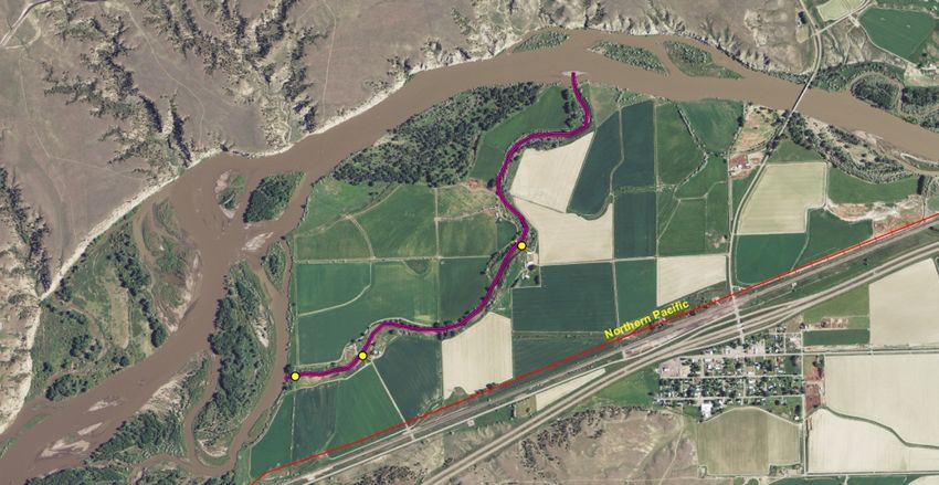
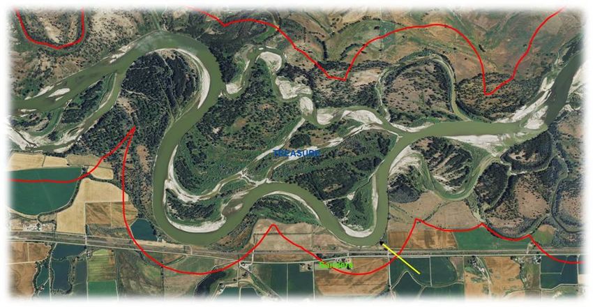
Table of Contents
Introduction ................................................................................................................................................................... 1
       Background ............................................................................................................................................................. 1
       Yellowstone River Recommended Practices (YRRPs) ............................................................................................. 1
       Position Statements ................................................................................................................................................ 1
       Acknowledgements ................................................................................................................................................ 2
YRRP 1.1 - Floodplain Restoration Agriculture and Urban/Residential Development ............................................... 3
       Implementation Approach ..................................................................................................................................... 5
YRRP 1.2 - Floodplain Restoration Active/Abandoned Railroads and Public Roads ................................................... 9
       Implementation Approach ................................................................................................................................... 11
YRRP 1.3 - Side Channel Blockage Removal ................................................................................................................ 13
       Implementation Approach ................................................................................................................................... 15
YRRP 2.1 - Channel Bank Stabilization ........................................................................................................................ 17
       Attachment #1: Rock Riprap Guidelines ............................................................................................................... 19
       Attachment #2: Concrete Riprap Guidelines ........................................................................................................ 21
       Attachment #3: Flow Deflector Guidelines .......................................................................................................... 23
       Implementation Approach ................................................................................................................................... 25
YRRP 3.1 - Riparian and Wetland Management ......................................................................................................... 31
       Attachment #1: Riparian and Wetland Grazing Management Guidelines ........................................................... 33
       Implementation Approach ................................................................................................................................... 35
YRRP 3.2 - Invasive Woody Plant Control ................................................................................................................... 37
       Implementation Approach ................................................................................................................................... 39
YRRP 3.3 - Noxious Weed Control ............................................................................................................................... 43
       Implementation Approach ................................................................................................................................... 45
YRRP 4.1 - Water Quality – Nutrient Reduction Agricultural Land Use ..................................................................... 47
YRRP 4.2 - Water Quality – Nutrient Reduction Residential Development – Small Tracts ....................................... 49
       Implementation Approach: YRRP 4.1 and 4.2 ...................................................................................................... 51
YRRP 5.1 - Solid Waste Removal ................................................................................................................................. 55
       Implementation Approach ................................................................................................................................... 57
YRRP 6.1 - Irrigation Water Management .................................................................................................................. 59
       Attachment #1: Irrigation Headworks .................................................................................................................. 61
       Attachment #2: Irrigation Conveyance - Canals and Pipelines............................................................................. 63
       Attachment #3: Irrigation On-Farm Irrigation Water Distribution Systems ......................................................... 65
                                                                                        i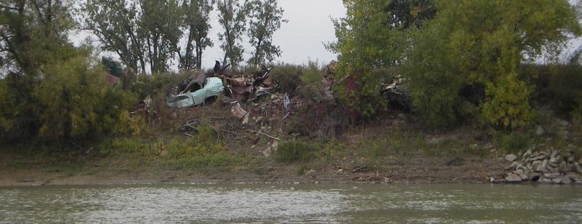
Implementation Approach .................................................................................................................................... 67
7.1 Position Statement – Oil/Gas/Brine Water Pipeline Crossings ........................................................................... 71
      Implementation Approach ................................................................................................................................... 72
8.1 Position Statement – Altered Flows...................................................................................................................... 73
      Implementation Approach .................................................................................................................................... 73

9.1 Position Statement – Channel Migration Zone Maps .......................................................................................... 75
      Implementation Approach ................................................................................................................................... 76
10.1 Position Statement – Fish Passage and Entrainment ......................................................................................... 77
      Implementation Approach ................................................................................................................................... 77
11.1 Position Statement – Watercraft Safety ............................................................................................................. 79
      Implementation Approach ................................................................................................................................... 80
12.1 Position Statement – Information Management .............................................................................................. 81
      Implementation Approach ................................................................................................................................... 81
Appendix A Reach Summary – Restoration Priorities .............................................................................................. 83

                                                                                 ii
Introduction
Background
All who live, work, or recreate along the Yellowstone River affect the river through their personal actions. Every
household, business, farm, government institution, and industry influences the long-term sustainability of the river
through their policies and operational protocols. We are all responsible to ensure that the ecological and economic
values associated with the Yellowstone River are maintained for generations to come.
This document supplements the 2015 Yellowstone River Cumulative Effects Analysis (CEA) that was completed on the
Yellowstone River corridor. The analysis was a joint effort led by the Yellowstone River Conservation District Council
(YRCDC) and the U.S. Army Corps of Engineers (ACOE) with active participation from multiple federal, state and local
agencies and other organizations with a vested interest in the river. The majority of the analysis focused on the
Yellowstone River corridor from Yellowstone National Park to its confluence with the Missouri River in North Dakota
(565 river miles); however, some components of the analysis encompassed the entire Yellowstone River Basin.
The intent of this document is to offer land management and structure design guidelines that address major impacts
identified in the CEA. These guidelines were developed as science-based Yellowstone River Recommended Practices
(YRRPs) and Position Statements. They are intended to provide guidance to Yellowstone River landowners, water users,
land management agencies, county officials, and other stakeholders when developing land management strategies
and/or building structures within the river corridor (i.e. 100-yr floodplain).
Reference citations have not been made in this document. Citations have instead been included in Chapter 8 of the
2015 Yellowstone River CEA Report.

Yellowstone River Recommended Practices (YRRPs)
 The objective behind the YRRPs is to promote an ecologically sustainable river that is necessary for preserving the long-
term economic viability of residents and communities who rely on the Yellowstone River. YRRPs are not rigid
prescriptions that should be applied to every situation. Instead, they are offered as guidance that encourages flexibility
and informed decision-making. The YRRPs provide technical and practical information to help stakeholders identify
potential problems or opportunities and to direct them towards a course of action that fits their objectives and
maintains river integrity.
Associated with each YRRP is an implementation approach that suggests specific activities to encourage the adoption
and implementation of the YRRP guidelines. The implementation approaches include outreach and educational
activities, agency coordination, restoration project priorities, and future data collection needs. Because they are
comprehensive, it is unrealistic to expect any one organization to take the lead in all listed activities. Developing MOUs
between the YRCDC and multiple agencies and organizations who work in the Yellowstone River Basin is a necessary
precursor for the effective coordination, promotion, and implementation of each YRRP.
Over time, as social norms and technology change, the YRRPs and the implementation approaches will be reviewed and
up-dated to remain current and relevant.

Position Statements
Position Statements are explanations, justifications, and/or recommendations for courses of action that reflect the
YRCDC’s stance on various issues associated with the Yellowstone River. Each statement outlines a consistent viewpoint
to be expressed in public meetings, land-use planning strategies, and policy development. Position Statements will be
reviewed and up-dated periodically to assure that they speak to the current status of an issue and accurately reflect the
YRCDC’s perspective.

                                                            1
Acknowledgements
During the development of the YRRPs and Position Statements, the YRCDC and members of their Technical Advisory
Committee (TAC) provided extensive reviews of multiple drafts. This final document reflects years of dedicated work
invested by the YRCDC, ACOE and TAC in developing the science upon which these YRRPs and Positions Statements are
built.

                                                         2
YRRP 1.1 - Floodplain Restoration
Agricultural and Urban/Residential Development
Background
Since the late 1800s, an increasing amount of Yellowstone River’s historic floodplain can no longer be accessed by flood
water. These traditionally flooded areas have become isolated for two reasons: constructed floodplain barriers (i.e.
urban levees, dikes, elevated roads, irrigation ditches, railroad berms, etc.) and a reduction in high flows caused by
storage reservoirs on tributaries and irrigation withdrawals. Nearly 5,000 acres of the historic 100-yr floodplain have
been lost due to dikes and levees that are associated with agriculture and urban/residential development.
Restoring and maintaining the connection between tributaries, the floodplain and the river’s active channel is critical to
the long-term sustainability of the river. Values associated with a functional floodplain include:
1. Water storage: During a flood, it is common for the floodplain to store at least 1 acre-foot of water per
acre. Once the flood subsides and the groundwater table begins to decline, some of the stored flood water
slowly returns to the river augmenting late summer and fall flows. Many variables affect flood water
storage potential: soil texture, vegetation, flood duration, pre-flood groundwater depth, land use, etc.
Example: 5,000 acres of floodplain flooded during the early summer stores 1 acre-foot of water per
acre. Over the next 2.5 months, the stored flood water (5,000 ac-ft) drains back to the river at an
estimated flow rate of about 30-35 cfs.
2. Agricultural production: Frequent overbank flooding deposits sediments and nutrients on the floodplain
rejuvenating agricultural lands and increasing crop production. However, large infrequent floods may
deposit deep layers of sand, heavy clay and debris on the floodplain that require debris removal and field
shaping.
3. Energy dissipation: By dispersing high energy flows across the floodplain, flows are not as concentrated in
the active channel; river bank erosion and channel scour are reduced.
4. Water quality: Floodplain vegetation serves as a filtration system that removes excess sediment and
nutrients as floodwaters cross the floodplain.
5. Riparian habitat: Riparian vegetation provides unique and important habitats for a wide variety of plants,
insects, reptiles, amphibians, birds and mammals. Even though periodic flooding can cause short-term
impacts to ground-nesting birds and small animals, a functional floodplain is essential for sustaining wildlife
habitat.
Old gravel dike pushed up on the floodplain
near Billings to protect a residential
development from flooding.
3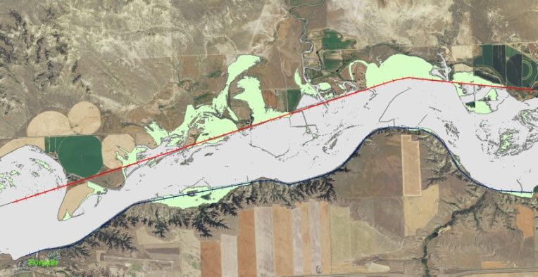
Recommended Management Guidelines
This YRRP provides general guidelines for the removal or modification of physical dikes and berms on the Yellowstone
River 100-yr floodplain. The primary land uses associated with floodplain dikes and berms include railroads, agriculture,
roads, and urban growth/rural small tracts.
• Old and Abandoned Structures: Remove old structures located on the 100-yr floodplain that are no longer
functional or needed. These structures may include abandoned buildings, irrigation infrastructure, solid waste
dumps, etc. Non-earthen material (wood, steel, tin, garbage) should be disposed of outside the 100-yr floodplain in
an approved landfill or recycling center. Once the structure is removed, the site should be graded back to the
normal floodplain elevation. All disturbances should be vegetated with species compatible with surrounding land
uses. Aggressive weed control may be necessary until the site is fully restored.
• New and Existing Structures: New structures should be located outside the 100-yr floodplain. When this is not
possible, the structure should be designed to minimize their footprint on the floodplain. Existing structures that are
significant floodplain obstacles or barriers should be relocated or modified to minimize impacts on the floodplain.
• Elevated Roads: For an elevated road, modifications can be made to allow a controlled amount of flood water
passage. Road modification designs should consider the road’s primary purpose, frequency of use, adjacent land
uses, drainage patterns, flood water entry/departure points, and the most appropriate method to pass flood waters
through a road berm (i.e. bridges, culverts, hardened swales, etc.). When the road provides the only access route to
residences, the design should strive to minimize the duration of road overtopping and the associated isolation of
those residences during floods. Flood by-pass structures should be designed to pass floodwaters as a shallow sheet-
flow rather than a concentrated channelized flow that could erode new gullies across the floodplain. A stable path
for floodwaters to return back to the river should also be included in the design.
• Agricultural Berms: Agricultural berms include elevated irrigation ditches, field dikes, and farm roads. These berms
not only restrict the spread of floodwaters, but will often catch or collect floating debris that will pile up on fields
and pastures. Larger floods will sometimes overtop or breach these berms resulting in concentrated flows that
sometimes erode deep rills and gullies across the fields.
Restoration Approach: If an agricultural berm is old and has outlived its purpose, total or partial removal of the
berm should be considered. The old berm should be graded back to the original floodplain elevation. The berm
material should either be transported off the floodplain or thinly spread on-site. For berms still in use,
modifications can be made to pass floodwaters and to effectively move floating debris. Any proposed design
should consider the same criteria outlined above for Elevated Roads.
• Urban Areas and Exurban Residential Tracts: There are urban areas and rural residential developments where
dikes and levees were built to protect homes and property from flooding. As these dikes and levees age, the costs
for repair and reconstruction can be extremely high. In these situations, it may be impractical and unpopular to fully
reconnect the historic floodplain to the river; however, measures to reduce their impacts are possible.
Existing Levees: When existing levees are repaired or rebuilt, they should be set back from the river to the
extent possible. In addition, the inclusion of fail-resistant spillways should be built into the levees so that
when the levee design is exceeded, excess flows pass through the spillway preventing catastrophic
overtopping or failure of the structure.
New Levees: New levees should be used as a last resort and only after other measures, especially
nonstructural ones, have been fully considered. Levees should not be used as a means to facilitate the
development of currently undeveloped floodprone lands.
4
Implementation Approach
1. Outreach and Education:
The YRCDC will coordinate with the DNRC Floodplain Management Bureau and the Association of Montana
Floodplain Managers (AMFM) on presenting Yellowstone River cumulative effects results and associated
YRRPs at AMFM’s annual conference (March), DNRC’s Floodplain Resource Seminar (July), and local “Flood
Awareness Days”. Targeted audience includes floodplain administrators, consultants, and landowners.
YRCDC will work closely with county floodplain administrators using the National Weather Service’s
Advanced Hydrological Prediction Service (AHPS) and NRCS snowpack/streamflow forecast to implement an
early warning system that alerts Yellowstone River residents of impending flood conditions.
Current information on floodplain restoration incentive programs will be distributed to landowners and
city/county officials through the local Conservation District, NRCS, and Extension Service offices.
Reach narratives provide brief summaries of floodplain information and unique characteristics for each of
the 88 Yellowstone River reaches. Applicable reach narratives will be distributed to landowners, city/county
officials, state/federal agencies, and other river users by the local Conservation Districts.
2. Restoration Guidance: YRCDC will facilitate the development of detailed restoration guidelines and specifications to
assist landowners in determining the most appropriate approach for modifying or removing floodplain dikes and
berms. These guidelines will be developed in cooperation with NRCS and the Montana Floodplain Management
Bureau. As a minimum, the guidelines will factor in the:
landowner objectives
original intent and current use of the dike or berm to be removed or modified
location of dike and berm on the floodplain; dikes and berms that lie within the 5-yr floodplain will be
considered a higher priority for removal or modification
amount of floodplain to be restored and the expected frequency of inundation
floodwater flow patterns (pre- and post restoration)
effects on existing land uses
effects on fish and wildlife
Applicable permit considerations.
3. 100-Yr Floodplain Maps: Where FEMA-approved floodplain maps are not yet available, the estimated 100-yr
floodplain boundaries, developed as part of the Yellowstone River Cumulative Effects Study (2015), should be used
as a land use decision-making guide for new developments. These maps are available at Conservation District and
County Floodplain offices. It is important to note that these floodplain maps are not FEMA-approved and should
only be used as a guide until FEMA-approved maps become available.
4. FEMA-Approved Floodplain Mapping: YRCDC will encourage all counties along the Yellowstone River to modernize
their FEMA-approved floodplain mapping on the Yellowstone River and major tributaries. A map showing the
current inventory of floodplain mapping (May 2015) in Montana is shown below.
5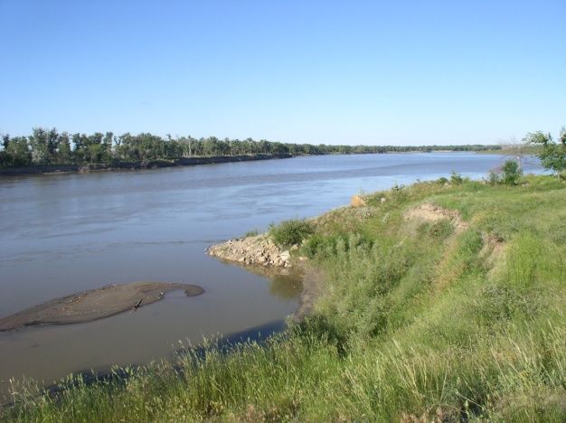
5. Floodplain Easements and Acquisitions: There are voluntary programs that may provide financial incentives and
restoration alternatives for lands subject to frequent flooding and flood damage. The YRCDC will encourage
interested landowners to contact the NRCS, county floodplain administrator and non-profit land trusts to determine
program provisions and eligibility. YRCDC will encourage Montana’s Congressional delegation to support future
funding of NRCS’s Emergency Watershed Protection Program – Floodplain Easement Program (EWP-FPE).
Floodplain Restoration Priorities – Potential Project Areas
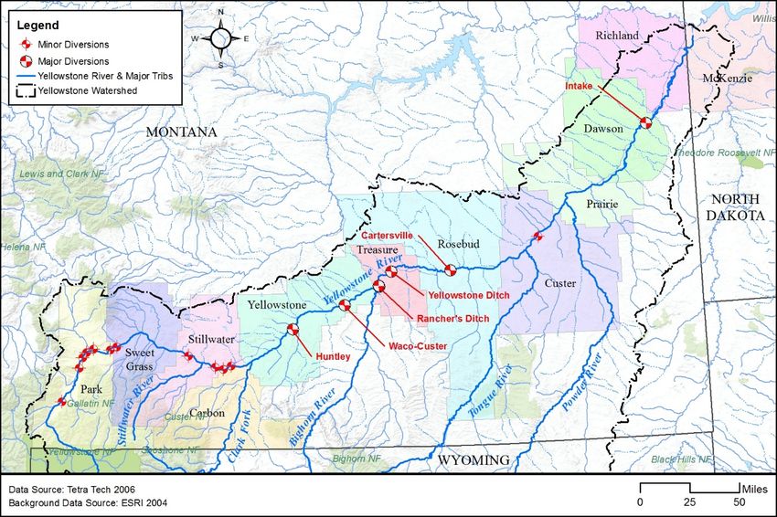
Criteria: Reaches that have more than 5% of the 100-yr floodplain isolated by dikes, berms or levees. All reaches listed
below have equal priority.
County Reach Description
Yellowstone County A-18 Agricultural (6.1% - 34 ac): Laurel to Clarks Fork River Confluence
B-6 Agricultural (11.4% - 209 ac): Upstream from Worden
Treasure County C-2 Agricultural (18.0% - 495 ac): Upstream from Meyers Bridge
C-3 Agricultural (8.6% - 233 ac): Meyers Bridge to Yellowstone Diversion
C-4 Agricultural (19.7% - 324 ac): Below Yellowstone Diversion
C-5 Agricultural (18.8% - 321 ac): Hysham Area
Rosebud County C-10 Urban (10.8% - 338 ac): Forsyth Area
Rosebud/Custer C-14 Agricultural (29.0% - 1,474 ac): Rosebud/Custer County Line
Custer County C-17 Urban (69.1% - 636 ac): Miles City Area
Dawson County D-6 Urban (9.2% - 176 ac): Glendive Area
Specific Restoration Project Recommendations
None identified
Additional Information & Data Needs
1) Water Storage: Quantify the potential for natural water storage of the current and historic Yellowstone River
floodplain. Determine the quantity and timing of the return of the floodplain’s stored water to the river for
6various flood frequencies in priority reaches listed above. Complete an economic analysis on the cost/benefits
of restoring floodplain function.
2) Flood Photography: For future flooding events, the YRCDC will proactively coordinate with county flood
administrators to sponsor a low-altitude corridor flight using high resolution photography to document actual
floodplain coverage. The flood frequency of the recorded event will be determined from the USGS gage
stations located along the Yellowstone River.
3) Reach Narrative Up-Dates: Every 10 years, the floodplain information contained in each reach narrative should
be reviewed and revised as needed. The next review is scheduled for 2025.
78
YRRP 1.2 - Floodplain Restoration
Active/Abandoned Railroads & Public Roads
Background
Transportation infrastructure (public roads and railroads combined) has a relatively small footprint on the 100-yr
Yellowstone River floodplain (approximately 3%). Even so, transportation corridors in the Yellowstone River Valley have
contributed to 37% of the total floodplain isolation.

The first railroad (Northern Pacific) entered the Yellowstone River Valley at Glendive in 1881. The Chicago, Milwaukee,
& St. Paul Railroad, commonly referred to as the Milwaukee Railroad, entered the valley 27 years later. The original
Northern Pacific grade (424 miles) that parallels the Yellowstone River is still in operation by Montana Rail Link (MRL)
from Livingston to Huntley; and the Burlington Northern Santa Fe (BNSF) from Huntley to Fairview. There is an
abandoned railroad grade between Livingston and Gardiner. The Milwaukee Railroad enters the valley west of Forsyth
and exits west of Fallon (approximately 97 miles). It has been abandoned since 1980.

The active railroad grade (MRL and BNSF) intermittently crosses the historic Yellowstone River 100-yr floodplain for a
total of 102 miles, isolating over 3,500 acres of floodplain. The abandoned railroad grade between Livingston and
Gardiner has little effect because Highway 89 lies between the river and the old grade. The Milwaukee Railroad
intersects the historic floodplain for a total of 25 miles leaving 2,300 acres of floodplain inaccessible to floods.

Public highways and county roads are more flexible in design and location and usually encroach upon the river’s
floodplain less than the railroads; however, they are still responsible for 2,050 acres of isolated floodplain. Most public
roads in the floodplain are two-lane highways or county roads. Interstate Highways 90 and 94, completed in the 1970s,
make up nearly 415 miles of roadway in the Yellowstone River Valley. They have a relatively small effect on the
floodplain since they are generally located on the periphery of the river valley.

           The abandoned Milwaukee Railroad grade crosses
           the historic floodplain west of Miles City. It is
           currently being used as an access road by the Fort
           Keogh Research Station.

Floodplain Restoration: Maintaining connectivity between tributaries, the historic floodplain and the river’s active
channel is critical. Values associated with a functional floodplain include:
       1. Water storage: It is common for the floodplain to store at least 1 acre-foot of water per acre during a
             flood. Stored flood water will eventually return to the river augmenting summer and fall flows.
       2. Energy dissipation: By dispersing high energy flows on the floodplain, flows are not as concentrated in the
             active channel; river bank erosion and channel scour are reduced and downstream flood damages lessened.
       3. Water quality: Floodplain vegetation serves as a filtration system that removes excess sediment and
             nutrients from the water as it slowly crosses the floodplain.
       4. Riparian habitat: Unique and important habitats are sustained for a wide variety of plants, insects, reptiles,
             amphibians, birds and mammals.

                                                             9
Recommended Management Guidelines
This YRRP provides guidelines on railroad and public road berms in the Yellowstone River 100-yr floodplain.
• Active Railroads: Opportunities to reconnect the historic floodplain isolated by the active railroad grade may be
limited. More practical restoration options would be associated with tributary connectivity and grade stabilization.
o Tributary Connectivity and Grade Stability: Establishing tributary connectivity to the Yellowstone River
would allow for fish passage, reclaim land lost from ponding or salinization, and minimize saturation and
slumping of the railroad grade. Culverts, pipes, concrete boxes, or small bridges should be installed through
the railroad grade to pass run-off flows from perennial, intermittent, and ephemeral side drainages. These
by-pass conduits should be sized to accommodate a 100-yr frequency flow to prevent ponding and
backwater against the upslope side of the grade and be designed for fish passage. Discharges through the
railroad berm will require a stable waterway to the river.
• Abandoned Railroad - Milwaukee: The Milwaukee railroad grade has been abandoned since 1980. Since it is no
longer maintained, it has become increasingly vulnerable to unchecked bank erosion and berm failure that could
have severe consequences to property once protected by the old grade.
o Floodplain Restoration: There is potential for
restoring the historic floodplain behind the
Milwaukee Railroad at some locations. A
systematic evaluation of the old railroad fill
should be completed to identify possible
projects for flood by-pass structures, strategic
breaching points and/or full grade removal.
Light green areas show the historic 100 year floodplain
isolated by the two railroad grades. The red line on the
north side of the river depicts the abandoned Milwaukee
Railroad.
• Public Highways and County Roads: Most public highways and county roads are either located outside the 100-yr
floodplain or are buffered by other floodplain berms, often the railroad grade. There may be opportunities to install
or enlarge flood by-pass structures on some public roads that would better accommodate side drainage runoff going
to the Yellowstone River and flood waters spreading out from the river. Floodplain restoration opportunities exist
with private driveways and farm roads located closer to the active river channel. YRRP 1.1 addresses private dikes
and roads.
• Bridges: Over 50 highway and railroad bridges cross the Yellowstone River. Most are publically owned. The only
private bridges are those owned by the railroad.
o Active Bridge Crossings: All future bridge construction or replacement should incorporate zero backwater
design standards (span, piers, and abutments) to minimize upstream gravel deposition and downstream
channel scour. Design standards should assure a bridge capacity that can readily pass 100+ year flood
events and not exacerbate localized ice jams.
o Abandoned Bridge Crossings: For bridges no longer in use, restoration projects should be initiated to
remove old bridge abutments and piers, and to grade bridge approaches back to the original floodplain
elevation.
10Implementation Approach
1. MRL and BNSF Railroad Berms: The YRCDC will collaborate with MRL, BNSF, and adjacent landowners on
identifying opportunities for installing new or modifying existing structures through the railroad berms that
adequately pass run-off flows from side tributaries to the river. The intent of these structures will be to reduce
ponding and the loss of land productivity behind the railroad berms. There may also be fish passage issues in some
locations that need to be addressed in the project design. See the Implementation Strategy for YRRP 6.1.
2. Public Highways and County Roads: YRCDC will investigate potential opportunities to install new or modify existing
structures through public roadways to allow flood relief from the Yellowstone River and to adequately pass run-off
flows from side tributaries to the river. YRCDC will work closely with Montana DOT, county road departments, and
adjacent landowners to identify sites where significant ponding and/or land loss is occurring behind public roads.
There may also be fish passage issues in some locations that need to be addressed in the project design. See the
Implementation Strategy for YRRP 6.1.
3. Milwaukee Railroad Berm: Since this railroad grade is no longer used or maintained, there may be more
opportunities to reconnect the river to the historic floodplain than exist with the active railroad.
Restoration Strategy: YRCDC will develop a general restoration strategy to assist interested landowners in
deciding on the most appropriate method for removing or modifying the railroad berm. The restoration
strategy will include a detailed evaluation of the Milwaukee Railroad grade to determine potential projects.
Prioritization criteria for projects will include:
adjacent landowner interest and objectives
the location of railroad berm on the floodplain
the amount of floodplain to be reclaimed and frequency of inundation
the location and stability of ingress (entry through the berm) and egress (pathway back to the
river)
floodwater flow patterns (pre- and post restoration)
the effects on existing land uses behind the railroad berm
estimated project costs
Landowner Outreach: Landowners will be personally contacted by the Rosebud and Custer
Conservation Districts to discuss restoration opportunities.
Floodplain Easements and Acquisitions: There are voluntary programs that may provide financial
incentives to restore the historic floodplain behind the Milwaukee Railroad grade. The YRCDC will
encourage interested landowners to contact their local Conservation District, NRCS, county floodplain
administrator and non-profit land trusts to determine program opportunities and eligibility.
Floodplain Restoration Priorities – Potential Project Areas
1) MRL and BNSF Railroad Berms: Nearly every reach (PC-14 to D-16) has an active railroad grade in the
Yellowstone River Valley. There are no targeted reaches at this time due to insufficient information on specific
sites. See section below on “Additional Information & Data Needs”.
2) Public Highways and County Roads: Every reach (PC-1 to D-16) has both public highways and county roads in
the valley. There are no targeted reaches at this time due to insufficient information on specific roads and
tributary by-pass structures.
3) Milwaukee Railroad Berm: Priority reaches extend from C-9 (West of Forsyth – Rosebud County) to C-16 (Fort
Keogh – Custer County).
11Specific Restoration Project Recommendations
None identified
Additional Information & Data Needs
1) Tributary Connectivity: The YRCDC will coordinate with MFWP and USFWS on an inventory of tributary barriers
to fish connectivity that includes roads, irrigation ditches, etc.
2) Milwaukee Railroad: The YRCDC will commission a detailed investigation of the Milwaukee Railroad grade to
identify potential floodplain restoration projects.
3) Flood Photography: For future flooding events, the YRCDC will coordinate with county flood administrators to
sponsor a low-altitude corridor flight using high resolution photography to document actual floodplain coverage
along the Yellowstone River. This is the same item as listed under YRRP 1.1.
12YRRP 1.3 - Side Channel Blockage Removal
Background
Numerous side-channels have been disconnected from the Yellowstone River’s main channel over the last 120 years.
The loss of these side channels is caused by physical blockages and the reduction in high flows. This YRRP focuses on
side-channel blockage removal. Between Gardiner and the Missouri River confluence, 42 miles of side channels have
been physically blocked on the mainstem Yellowstone River prior to 1950; another 48 miles were added between 1950
and 2001. This represents over 15% of the side channels along the Yellowstone River that have some form of blockage.
Functional, open side channels are one of the most important features on the Yellowstone River for maintaining healthy
fish populations. The values associated with side-channels include:
1. Habitat: Side channels provide critical habitat and refuge for fish, amphibians, reptiles, birds, and other
aquatic life on the Yellowstone River. During high flows, side channels tend to be shallower with slower
velocities, warmer water temperatures, more habitat diversity, and higher productivity (fish recruitment and
food sources) when compared to the main channel.
2. Flood Relief: Keeping side channels open to high flows helps disperse high energy flows. Allowing high
water to access side channels lessens the concentrated flow in the main channel resulting in reduced bank
erosion and channel scour, and less flood damage downstream.
Over the last century, side channels have been
blocked for various reasons, often to provide access
to lands along the river or to prevent high flows
from damaging property on the adjacent floodplain.
Recommended Management Guidelines
This YRRP provides general guidelines for the removal or modification of physical blockages that would significantly
benefit aquatic habitat and flood relief.
• Total Blockage Removal: Completely removing a side channel blockage to restore high water flow access is the best
alternative when restoring side channel function and value. The pros and cons of implementing complete removal
should be considered early on in the planning process.
• Water Control Structures: Where blockage removal presents too high a risk (flooding, river capture, bank
destabilization), retrofitting or replacing the physical blockage with a water control structure (i.e. culvert, bridge,
constructed overflow channel, etc.) to regulate high flow access and provide fish passage may be a viable option.
This alternative may not provide full functionality to the side channel, but impacts to aquatic habitat would be
reduced.
13• Side Channel Restoration: Restoration work to the channel is often necessary in addition to modifying or removing
the side channel blockages. This may include excavating accumulated sediment from the side channel, channel
shaping, grade control to prevent river capture, removing invasive species that have encroached on the channel, and
constructing fish habitat (pools, spawning substrate, woody cover, etc.) that is conducive to the local fisheries or
possibly to a targeted species.
• Maintaining Existing Side-Channels: For side-channels currently connected to the river, their continued function as
habitat and flood relief should be an important objective in each landowner’s long-term management plan.
• Adjacent Land Planning: For reactivated side channels, flood hazard remediation may be necessary to address
increased flood potential on fields and infrastructure next to or down-gradient of the side channel. Remediation
could be in the form of vegetative buffers, structure relocation or floodplain easements.
• Restoration Project Monitoring: A monitoring plan should be developed to determine if the project met its
restoration goals and whether additional “tweaking” would be necessary to make the project more effective.
Monitoring would also provide insight on restoration designs for other side channels in similar settings.
N
A side channel in Yellowstone County that has been blocked for over 65 years.
The purple line is the side channel and the yellow symbols are locations of the
blockages.
14Implementation Approach
Side Channel Restoration Strategy
1. Outreach Program: The YRCDC will work closely with individual Conservation Districts and Montana FW&P on
implementing an outreach program to landowners who own or border blocked side channels. The outreach will
include information on side channel restoration; solicit landowner interest in pursuing a demonstration project;
and offer on-site visits (YRCDC TAC, NRCS, and/or FWP) to collect more site-specific information.
2. Project Funding: YRCDC will assist the landowner in seeking funding to complete the project design and
construction. This type of restoration project would be highly competitive in state, federal and private incentive
programs. If there is enough interest, YRCDC will work with state and federal agencies, and non-profit
organizations, to expand incentive-based funding programs for side channel restoration.
3. Monitoring: YRCDC will coordinate with Montana FW&P on developing monitoring plans for each restoration
project to determine effectiveness.
Side Channel Restoration Priorities – Potential Project Areas
Criteria: Reaches that have blocked side channel are included in the priority list below. For each county, a reach-based
map showing blocked side channels will be available to landowners and the general public through the local
Conservation District Office and online.
Note: The blocked side channels listed below were identified using high aerial photography. It is sometimes difficult to
determine the nature of the blockage. Any errors in the list can be corrected with on-site visits.
County Reach Description
Park PC-5 3500 feet Upstream from Big Creek confluence
PC-7 3000 feet Upstream from Grey Owl
PC-10 8450 feet Near Weeping Wall, Jumping Rainbow
PC-11 2000 feet Near Suce Creek confluence; Wineglass Mtn
PC-14 14150 feet Livingston Area
PC-16 1900 feet Upstream Hwy 89 Bridge
PC-17 3950 feet 89 Hwy Bridge to Shields River confluence
PC-18 11400 feet Mission Creek Area
Sweet Grass A-1 2970 feet Springdale Area
A-2 3125 feet Grey Bear
A-4 7575 feet Big Timber Area
A-6 2700 feet Upstream from Greycliff
A-7 9350 feet Greycliff
A-8 4650 feet Downstream from Greycliff
A-9 3720 feet Upstream from Reedpoint
Stillwater A-9 2700 feet Reedpoint Area
A-11 6750 feet I-90 Bridge Crossing
A-12 3750 feet Upstream from Stillwater River confluence
A-14 18850 feet Downstream from Columbus
A-15 1620 feet Upstream from Park City
A-17 2000 feet Upstream from Laurel
15County Reach Description
Yellowstone A-17 5650 feet Upstream from Laurel
B-1 19800 feet Downstream from Clarks Fork confluence
B-2 6570 feet Billings Area
B-3 24700 feet Downstream from Billings
B-5 11400 feet Huntley Area
B-6 1350 feet Downstream from Huntley
B-8 6200 feet Pompey’s Pillar
B-9 7950 feet Downstream from Pompey’s Pillar
B-10 3350 feet Upstream from Custer Bridge
B-11 1000 feet Custer Bridge
Treasure C-1 7170 feet Downstream from Big Horn River confluence
C-2 11630 feet Upstream from Meyers Bridge
C-5 8830 feet Hysham Area
C-6 10910 feet Mission Valley
C-7 19800 feet Mission Valley
C-8 2320 feet Treasure/Rosebud County Line
Rosebud C-8 8500 feet Treasure/Rosebud County Line
C-9 19350 feet Hammond Valley
C-11 22745 feet Upstream from Cartersville Bridge
C-12 9080 feet Community of Rosebud
C-13 4575 feet Downstream from Rosebud
C-14 15000 feet Rosebud/Custer County Line
Custer C-17 1470 feet Miles City Area
C-18 1050 feet Downstream from Miles City
C-19 17360 feet Kinsey Bridge Area
Dawson D-4 8550 feet Downstream from Prairie/Dawson County Line
D-5 9070 feet Upstream from Glendive
D-6 33500 feet Glendive
D-9 21430 feet Downstream from Intake
Richland D-11 15600 feet Elk Island Area
D-12 14625 feet Crane Area
D-14 3600 feet Upstream from Richland/McKenzie County Line
Specific Restoration Project Recommendations
None identified
Additional Information & Data Needs
1) On-Site Side Channel Evaluations: The YRCDC will sponsor an on-site investigation of blocked side channels with
interested landowners to determine: 1) the original purpose for the blockage, 2) current condition of blockage,
3) restoration potential, and 4) landowner interest. The priority list and side channel mapping above will be
edited to reflect the results from the investigation. This investigation will also include discussions with Montana
FW&P on the relative importance of individual side channels for the local fisheries and other aquatic life.
2) Flood Photography: For future flooding events, the YRCDC will coordinate with county flood administrators to
sponsor a low-altitude corridor flight using high resolution photography to document actual side channel
inundation. This is the same item as listed under YRRP 1.1.
16YRRP 2.1 - Channel Bank Stabilization
Background
The Yellowstone River is a naturally meandering river which causes banks to erode and channels to shift. In winter,
anchor ice and ice jams can be another major factor affecting bank erosion. Eroding river banks are a normal function of
the river and don’t always need to be “repaired”. In fact, bank treatments that lock the river channel in place will
cumulatively impact the river by restricting riparian forest renewal, degrading fisheries habitat, and lessening the river’s
ability to adjust to fluctuating flows and bedload. Since the late 1800s, an increasing amount of infrastructure and
cropland has been developed on the floodplain without much thought given to the dynamic nature of the Yellowstone
River. And, as is often the case, the river channel will move, forcing landowners to decide whether investing in bank
protection is worth the expense and risk.
As of 2011, there are approximately 136 miles of bank armor on the Yellowstone River from Gardiner to the Missouri
River. This is equivalent to 12% of the Yellowstone River (main channel plus active side channels).
The primary land uses protected by bank armor are agriculture-related (irrigated lands and infrastructure) at 37% and
railroad rights-of-way at 36%. The remaining land uses with bank armor include urban/exurban, 11%; non-irrigated
lands, 9%; and public roads, 7%.
The most common type of bank armor is rock riprap at 75%. Concrete riprap and flow deflectors account for 23%. Car
bodies, gabions, steel retaining walls, and soft bioengineering make up the remainder at 2%.
Channel Migration Zone (CMZ) Maps: CMZ maps define areas along the Yellowstone River that are prone to bank
erosion over the next 100 years. CMZ map boundaries are based upon detailed geologic mapping of the valley bottom
and measured rates of lateral channel change derived from fifty years of historic aerial photography. The use of CMZ
maps are an important tool for decision-makers along the Yellowstone River that will significantly lessen the risk of
infrastructure wash-out and minimize the necessity for expensive bank armoring. CMZ maps of the Yellowstone River
are available at local Conservation District Offices.
Material used for bank armor on the
Yellowstone River is mostly sandstone rock,
although salvaged concrete is often used
near towns and urban areas.
Recommended Management Guidelines
This YRRP outlines guidelines and planning considerations for making decisions about bank stabilization and the
materials and techniques that may be most appropriate:
Structures – Channel Migration Zone: Most landowners and state/local government invest in bank armor to
protect high-value structures (i.e. houses, outbuildings, irrigation sprinklers, roads, etc.) being threatened by the
river. Since bank armor is costly to install and maintain, and often subject to failure, building structures outside the
Channel Migration Zone is the least expensive option. If armoring a bank is unavoidable, bank stabilization
guidelines are attached to this YRRP.
17Agricultural Lands
o Cost/Benefit: For cropland, riparian forest, pastureland, etc. being threatened by river migration and
bank erosion, the CMZ map predicts the amount of land that may be lost if bank stabilization is not
pursued. This acreage estimate provides information to determine economic costs/benefits comparing
property values and long-term production losses with bank armor installation and long-term
maintenance costs. Although most people do not want to lose land to the river, the expense of bank
armor required to adequately protect some properties may not be economically justified.
o Flood Irrigation – Bank Saturation: Irrigation ditches and flood irrigated fields located too close to the
river channel will often saturate the river bank. Saturation causes the river bank to become vulnerable
to sloughing and accelerated erosion. This will often lead to expensive bank armor that ends up dealing
with the symptom rather than the actual problem. There are different options to address bank
saturation depending upon landowner objectives and site conditions:
Relocate irrigation ditches away from the river channel
Line irrigation ditches or replace with buried pipelines to reduce seepage
Develop a flood irrigation tailwater system that transports waste water efficiently off the field
Plant a vegetative buffer between the river and irrigated field, ideally the width of the CMZ. The
buffer should be planted with deep-rooted native plants.
o Sprinkler Irrigation: All new sprinkler systems (above- and below-ground components) should be
located outside the CMZ to avoid the future expense of system relocation or bank armor. For existing
system upgrades, reorienting fields and installing sprinkler pivot points and supply lines outside the CMZ
would lessen the need for future bank armor.
Channel Migration Zone (CMZ) Easements: CMZ easements may be an alternative to bank armoring in that
they maintain the ability of the river to migrate while offering opportunities for landowners to realize return on their
land. CMZ easements offer compensation to landowners for land that may potentially be lost to the river within the
CMZ boundary, either through direct payments or tax incentives. The CMZ easement programs are in their infancy
so availability may not meet the demand over the next few years. Inquire with your local Conservation District on
CMZ easement opportunities.
Failed Bank Armor Removal: Failed bank armor and flanked flow deflectors sometimes end up as rubble in the
active river channel. This rubble will often deflect the current into the bank, thereby accelerating the bank erosion
that it was originally intended to stop. It also creates a safety hazard for boaters and recreationists and a potential
liability to the landowner. Failed bank armoring and flow deflectors should be removed from the active channel.
The material should then be either reused or transported off-site.
Rock riprap flanked by high flows now
located in the middle of the river.
18YRRP 2.1 Attachment #1: Rock Riprap Guidelines
Economics: The value of the property or structure to be protected should be compared to the annualized cost of
installing rock riprap over its expected lifespan. An objective cost/benefit analysis usually concludes that only high
value assets justify the high cost of ‘hard’ bank protection. The installation costs are only the beginning. On a high-
energy river like the Yellowstone, periodic expenditures of money and time will be necessary to prevent the bank armor
from failing. Maintenance expenses should be included in the calculation of project costs and benefits.
Channel Migration Zone (CMZ) maps help determine historic channel migration rates and projected land loss over the
next 100 years. CMZ maps are based upon historical aerial photos that show how the channel has changed over the last
75 years. 100-yr CMZ maps and historic aerial photos are available at the local Conservation District Office.
Example Cost/Benefit: The CMZ map predicts that two acres of irrigated hay land valued at $3,000/ac may eventually
be lost if the bank is not armored. Net annual production income (irrigated hay – 4 tons/acre at $100/ton) averages
$400/acre/year.
Rock Riprap Installation Cost – 200 feet * $40,000 The EAC of $3360/yr for 25 years is greater
Cost of Capital – 4%
than the land value of $6,000 + lost
Expected Lifespan 25 years
production ($800/yr for 25 years = $20,000).
Annual Maintenance Costs (2%) $800 For this example, installing rock riprap to
(Rock replacement, weed control, etc.)
protect two acres of irrigated hay land would
Equivalent Annual Cost (EAC) $3360
(Investment Cost + Maintenance Costs) not be economically justified.
* Properly installed rock riprap will often exceed $200/linear foot
The EAC analysis described above does not take into account the recreational, intrinsic and ecological values lost by
armoring the river channel.
Another financial cost not often considered when planning riprap projects is finding rock of sufficient strength and
durability to last 25 years. Adequate rock quality is not readily available along most of the Yellowstone River. This often
means that rock transported from distant quarries significantly raises the cost of installing rock riprap.
Given the high cost of rock riprap, bank armoring is usually limited to sites where high-value property is being
threatened. Bridge abutments, permanent irrigation structures, and buildings are sites where the expense of rock riprap
may be worth the investment.
Rock riprap may be economically justified if
high-value infrastructure like the irrigation
pump is being protected.
Risk is defined as the potential for bank armor failure. Rock riprap is considered to be a bank armoring approach that
typically has a high cost with a relatively low risk of failure if properly installed. To reduce the risk of failure, the
guidelines listed below should be followed.
19Rock Riprap: Design and Installation Guidelines
The following are general guidelines to consider when installing rock riprap. To reduce the risk of bank armor failure, a
qualified river specialist should evaluate, design, and oversee installation of all bank armoring projects.
• Off-Site Effects: Carefully evaluate possible off-site impacts to upstream, downstream and opposite bank
properties. Rock rip-rap may divert the current to an unprotected bank, shifting the bank erosion elsewhere.
• Rock Quality: Use hard angular rock, properly sized and graded. Rock density should exceed 1.3 tons/CY.
Round river rock or soft sandstone will not stand up to the Yellowstone River’s high energy flows or winter ice
for any length of time.
• Filter Blanket: Uniformly lay gravel, sand, or crushed rock to a minimum thickness of 8 inches to prevent
scouring of fine soils beneath the rock riprap.
• Bank Slope: Shape the river bank to a 2:1 slope or less. The flatter the slope, the less risk of failure. Excavated
bank material is then transported off-site or spread thinly on the adjacent floodplain. There shouldn’t be any
elevated spoil piles or dikes that would impede or deflect over-bank flooding.
• Key Rock Into Channel Bed: Excavate and “key in” the base or “toe” of the rock riprap below the elevation of
anticipated bed scour. The riprap toe is the zone of highest erosive stress from water, ice, and the weight of the
rock riprap. A poorly installed toe is a common reason for riprap failure.
• Key Rock into Bank: Key additional rock into the upstream and downstream ends of the rock riprap to reduce
the likelihood of the river flanking the riprap. The upstream bank key should be oriented at a 30 to 45 degree
angle into the bank pointed upstream.
• Rock Placement: Rock riprap should be carefully placed on the sloped bank by an experienced excavator
operator. Some hand work is often necessary to fit smaller rocks in the voids between the larger rocks. Soil
should be incorporated with the rock to facilitate the establishment of vegetation (“dirty riprap”). Rock should
never be dumped off the bank or left on the top of the bank for the river to undermine it. Rock riprap typically
does not need to extend up the shaped bank any higher than the “channel-forming” flow event (high water
elevation 2 years out of 3).
• Vegetation: Incorporate deep-rooted native vegetation into the rock riprap. Additional vegetation should be
densely planted on the shaped bank above the riprap up to the top of the bank. Aggressively control weeds for
three years on all disturbed areas.
Treatment of High Banks – Constructed Bankfull Bench Method
The constructed bankfull bench method is an approach sometimes used to stabilize high, steep banks. This method
involves placing gravel fill along the base of the eroding or slumping bank to support a flat narrow floodplain bench 1 to
2 feet above the height of the opposite bank (bankfull elevation). This gravel bench provides drainage and a stable fill to
support the riprap.
On rare occasions, instead of placing fill, the bench may be excavated into the existing bank. This alternative does not
require the gravel fill, but usually generates large quantities of excavated materials that need to be transported off-site.
It may also cause the upper bank, above the constructed bench, to become steeper and less stable.
• Constructed Bench: The bench is flat and usually a minimum of 4 feet wide.
• Rock Riprap: The fill is graded to a 2:1 slope or less from the toe of the bank to the bench elevation. The fill
slope can then be protected using the same guidelines outlined for rock riprap.
• Vegetation: The bench and upper slope are covered with coir fiber matting and planted with deep rooted
native shrubs.
20YRRP 2.1 Attachment #2: Concrete Riprap Guidelines
Near towns and urban areas, concrete rubble salvaged from buildings, foundations, and sidewalks is sometimes used as
material for bank armor, instead of rock. Salvaged concrete should be used as a last resort, only when suitable rock is
not available. Concrete rubble may be cheaper than rock, but the preparation and placement of concrete riprap is more
difficult with a higher risk of failure. Concrete riprap also is especially susceptible to damage by ice.
Economics: The value of the property or structure to be protected should be compared to the annualized cost of
installing concrete riprap over its expected lifespan. An objective cost/benefit analysis usually concludes that only high
value assets justify the high cost of ‘hard’ bank protection. The installation costs are only the beginning. On a high-
energy river like the Yellowstone, periodic expenditures of money and time will be necessary to prevent the bank armor
from failing. Maintenance expenses should be included in the calculation of project costs and benefits.
Channel Migration Zone (CMZ) maps help determine historic channel migration rates and projected land loss over the
next 100 years. CMZ maps are based upon historical aerial photos that show how the channel has changed over the last
75 years. 100-yr CMZ maps and historic aerial photos are available at the local Conservation District Office.
Example Cost/Benefit: The CMZ map predicts that two acres of irrigated hay land valued at $3,000 may eventually be
lost if not armored. Net annual production income (irrigated hay – 4 tons/acre at $100/ton) averages $400/year.
Concrete Riprap Installation Cost $30,000
(Cost of Capital: 4%) The EAC of $2805/yr for 20 years is greater
20 years than the land value of $6,000 + lost
Expected Lifespan
production ($800/yr for 25 years = $20,000).
Annual Maintenance Costs (2%) $600
(Concrete replacement, weed control, etc.) For this example, investing in concrete riprap
Equivalent Annual Cost (EAC) to protect two acres of irrigated hay land
$2805
(Investment Cost + Maintenance Costs) would not be economically justified.
The EAC analysis described above does not take into account the recreational, intrinsic and ecological values lost by
armoring the river channel.
Given the high cost of concrete riprap, bank armoring is usually limited to sites where high-value property is being
threatened. Bridge abutments, permanent irrigation structures, and buildings are sites where the expense of bank
armor may be worth the investment.
Concrete blocks dumped on the river bank. This
attempt at bank armoring will likely accelerate
the rate of bank erosion rather than prevent it.
21You can also read