Drummond Natural Diversity Recovery Catchment recovery plan 2011-2031 August 2013
←
→
Page content transcription
If your browser does not render page correctly, please read the page content below
Drummond Natural Diversity Recovery Catchment
                    recovery plan 2011–2031

                                 August 2013
Department of Parks and Wildlife
Locked Bag 104
Bentley Delivery Centre WA 6983
Phone: (08) 9219 9000
Fax: (08) 9334 0498

© State of Western Australia 2013

August 2013

This work is copyright. You may download, display, print and reproduce this material in unaltered form only (retaining this
notice) for your personal, non-commercial use or use within your organisation. Apart from any use as permitted under the
Copyright Act 1968, all other rights are reserved. Requests and enquiries concerning reproduction and rights should be
addressed to the Department of Parks and Wildlife.

Questions regarding the use of this material should be directed to:
Manager, Natural Resources Branch
Department of Parks and Wildlife
Locked Bag 104
Bentley Delivery Centre
Western Australia 6983
Phone: (08) 9334 0209

The recommended reference for this publication is:
Department of Parks and Wildlife, 2013, Drummond Natural Diversity Recovery catchment plan 2011–2031,
Department of Parks and Wildlife, Perth.

Note

This plan was prepared by the Department of Environment and Conservation (DEC), which on 1 July 2013 separated to
become the Department of Parks and Wildlife (DPaW), and the Department of Environment Regulation. While the
Department of Parks and Wildlife printed this plan in July 2013, many actions outlined were already underway by the
then DEC.

This document is available in alternative formats on request.

Disclaimer

While all reasonable care has been taken in the preparation of the material in this document, the Government of Western
Australia and its officers accept no responsibility for any errors or omissions it may contain, whether caused by negligence or
otherwise, or any loss, however caused, sustained by any person who relies on it.

Supporting information

The document Drummond Natural Diversity Recovery Catchment supporting information includes detailed information on
physical characteristics of the catchment. The separate supporting information document, referred to in this plan as
Appendices, also develops and explains important issues that would otherwise need significant diversions in the recovery
plan. The intent is to improve the readability of the document. An attachment is included as part of this recovery plan.

Acknowledgments

DPaW would like to thank the following people for their involvement in the development of the Drummond Natural Diversity
Recovery Catchment recovery plan 2011–2031.

In particular, past and present members of the Drummond Natural Diversity Recovery Catchment Advisory Committee:
Geoff Erickson, Matt Edmonds, Bethan Lloyd, Frank Rickwood, Robert Huston, Ken Wallace, David Cale, Geoff Barrett,
Greg Keighery, Stefan De Haan, Prue Dufty.

DPaW technical advisory group: Ken Wallace, David Mitchell, Matt Forbes, Robert Huston, Adrian Pinder, Mike Lyons.

DPaW planning support staff: Rosemary Jasper, Alisa Krasnostein, Jennifer Higbid.

A number of individuals also provided valuable input: Ryan Vogwill, Wendy Chow, Mark Garkaklis, Michael Coote.

                                                                1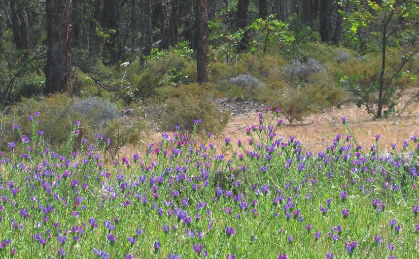
Drummond Natural Diversity
Recovery Catchment recovery plan
           2011–2031

               1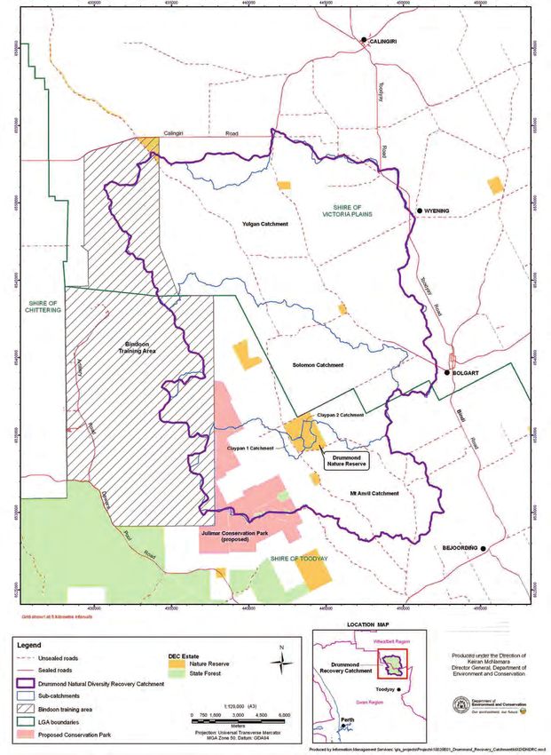
CONTENTS                                                      Figures
Summary                                               4       Figure 1 The planning and management
                                                              process for natural diversity recovery catchments       9
1   Salinity, biodiversity and the role of recovery
                                                              Figure 2 Hierarchy of planning terms used in
    catchments                                       5
                                                              the recovery plan                                      28
The threat of salinity to biodiversity               5
Secondary salinity and altered hydrology             6        Figure 3 Drummond Nature Reserve conceptual
Natural Diversity Recovery Catchment program         6        hydrological model.                                    30
Priority setting for salinity actions                7        Figure 4 Quantity, quality and cause-effect
Planning process                                     8        linkages arising from changes to water balance         31
2 Description of the Drummond NDRC                   10       Figure 5 Risk of unacceptable impacts to claypan
Planning area                                        10       biota and fringing vegetation in a 20-year timeframe   32
Catchment overview                                   10
                                                              Tables
Social and economic characteristics                  10
Cultural heritage                                    11       Table 1 Overview of the administrative areas of
Physical characteristics                             11       the DNDRC                                              10

3 Biodiversity values and management goals           12       Table 2 Annual rainfall total averages at Bolgart      11
Cultural values and biodiversity conservation        12       Table 3 Linking recovery achievements to priority
The goal of the Drummond NDRC                        13       cultural values and related assets                     18
Sustainable land use goal                            14       Table 4 Probability (%) of specific ecosystem
Responsibilities and ownership of goal                        processes causing goal failure in the DNDRC with
implementation                                       14       and without management                                 20
Opportunities for engagement                         15
                                                              Table 5 Summary of threats to biodiversity assets
4 Biodiversity assets                                15       posed by altered hydrology                             29
Priority biodiversity assets threatened by altered
                                                              Table 6 Management actions to address surface
hydrology                                            15
                                                              and groundwater threats – altered hydrology and
Biodiversity assets requiring hydrological
                                                              salinity impacts on biodiversity assets                34
investigation                                        18
                                                              Table 7 IOCI climate predictions averaged over the
5 Setting management action priorities               19
                                                              entire south-west (IOCI 2005)                          35
Biophysical threat analysis                          19
                                                              Table 8 Management actions to address the
Threat analysis summary                              27
                                                              impact of climate change on the altered
Technical capacity and knowledge                     27
                                                              hydrology and biodiversity assets                      36
Sociopolitical support                               27
                                                              Table 9 Management actions to address the
6   Managing threats to priority biodiversity
                                                              most serious weed species recorded from or
    assets                                           27
                                                              near Drummond Nature Reserve                           38
Approach                                             27
Planning terminology                                 28       Table 10 Management actions to address impacts
Managing the threats to goal achievement             29       of introduced and problem plants and animals
Progress to date                                     43       and disease                                            41
Outcomes 2001–2006                                   45       Table 11 Management actions to address threats
7 Implementation, monitoring and evaluation          46       to biodiversity assets – detrimental regimes of
Monitoring and evaluation framework                  46       physical disturbance                                   42
Implementation process                               51       Table 12 Building an appropriate culture               43
Annual reporting process                             51       Table 13 Summary of recovery catchment
                                                              expenditure and outputs against core activities
Attachments
                                                              2001–2006.                                             45
Attachment 1 The spatial scale of the
Drummond NDRC goal                                   54       Table 14 Proposed monitoring targets                   49

Acronyms                                             55       Table 15 Threat categories and timeline for delivery
                                                              of management outputs                                  52
Glossary                                             56
References                                           60
Personal communications                              63

                                                          3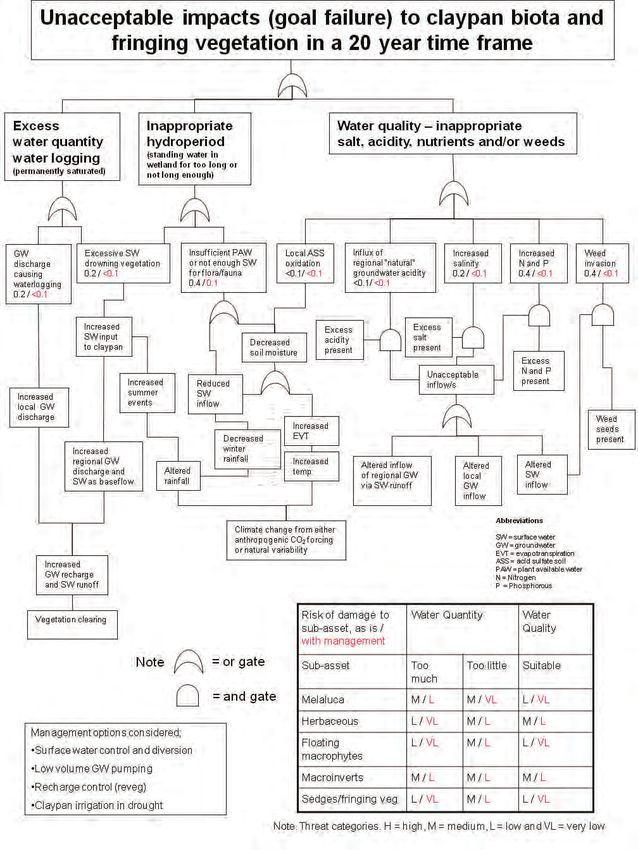
Summary it will be necessary to conserve the 2011 composition and
structure of native biota threatened by altered hydrology.
This recovery plan describes the biodiversity values In the context of the goal, the most important biodiversity
threatened by altered hydrology, particularly salinity, in the assets are the two vegetated claypan wetlands in DNR. As
Drummond Natural Diversity Recovery Catchment (DNDRC) our understanding of the hydrology of DNR is incomplete,
and provides the management actions that will guide the other biodiversity assets may also be threatened by altered
conservation of these values for the planning period. The hydrology and therefore further hydrological investigation
plan is a source of information and a management guide is required.
for catchment managers, land-holders and community
A biophysical threat analysis was undertaken to evaluate
members.
the key ecosystem processes that must be managed to
Natural diversity recovery catchments are a state protect the biodiversity assets and achieve the goal. As a
government commitment under the Salinity Strategy and result, the most important management issues that are
are one response to secondary salinity, a major threat considered likely to cause goal failure include:
to the biodiversity of south-west Australia. Recovery
catchments provide a focus for government and • hydrological processes, including salinity
community actions to protect regionally significant, high • environmental weeds
priority biodiversity assets, especially wetlands at risk from • nutrient cycles, including eutrophication
altered hydrology. Recovery catchments are managed
• detrimental fire regimes
by the Department of Parks and Wildlife, which has a
statutory responsibility to conserve biodiversity in Western • attitudes toward saving assets from salinity threats,
Australia. in particular, inadequate understanding of the
contribution by biodiversity assets to human quality of
The primary goal of recovery catchments is biodiversity
life.
conservation; however, they are also important for
investigating and implementing solutions to salinity. This The threat analysis indicates that with additional
secondary goal recognises that successful management of management the probability of goal failure can be reduced
recovery catchments requires research and development of to an acceptable level for all the above management
sustainable forms of agriculture, which are environmentally issues. Key management actions to assist in goal
sensitive and economically viable. achievement have been identified such as: more detailed
investigations of biodiversity assets; hydrological studies
The DNDRC was established in 2001 as the sixth recovery
and the preparation of a water management strategy;
catchment. Selection was informed by the results of
revegetation and protection of remnant vegetation
the wheatbelt biological survey and by addressing the
on private property; investigating potential climate
recovery catchment criteria. The catchment covers an
change impacts; weed management, plant disease and
area of 37,866 hectares and is located approximately
problem fauna species control; appropriate fire regimes
100 kilometres north-east of Perth in a long-established
investigated; and the development of a communication
farming area, with less than a third of the catchment
plan.
remaining as native vegetation. The management focus
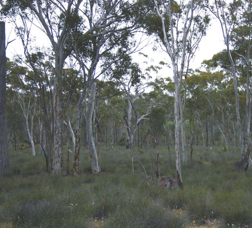
within the catchment is two relatively undisturbed Work in the catchment to date has focused on
freshwater claypan wetlands situated within Drummond hydrological and biological investigations to provide the
Nature Reserve (DNR). These claypans are examples of basis for effective management planning. On-ground
wetland types that are rare in the wheatbelt. The DNR works have also been undertaken that will contribute
claypans are in near-pristine condition and contain a towards the management of altered hydrology including:
priority ecological community, a number of declared rare
• a network to monitor surface and groundwater
and priority flora, and high aquatic invertebrate richness.
• containment of a weed population in DNR
The goal of the DNDRC was determined by describing
and prioritising the cultural values of biodiversity assets • revegetation and fencing in the surface water
threatened by altered hydrology in the catchment and is: catchment north-west of DNR
To deliver the scientific and educational values, • revegetation of a degraded area in DNR
opportunity values and system benefits values derived • planning activities and community consultation.
from the current (2011) composition and structure A framework for monitoring and evaluation has been
of biodiversity assets of the DNR threatened by altered established to measure progress and performance during
hydrology for the next 20 years. implementation of the recovery plan. Progress towards
To achieve the goal and deliver the priority values of achieving the goal for the catchment will be measured
science and education, opportunity and system benefits, against monitoring targets which are of two types –
4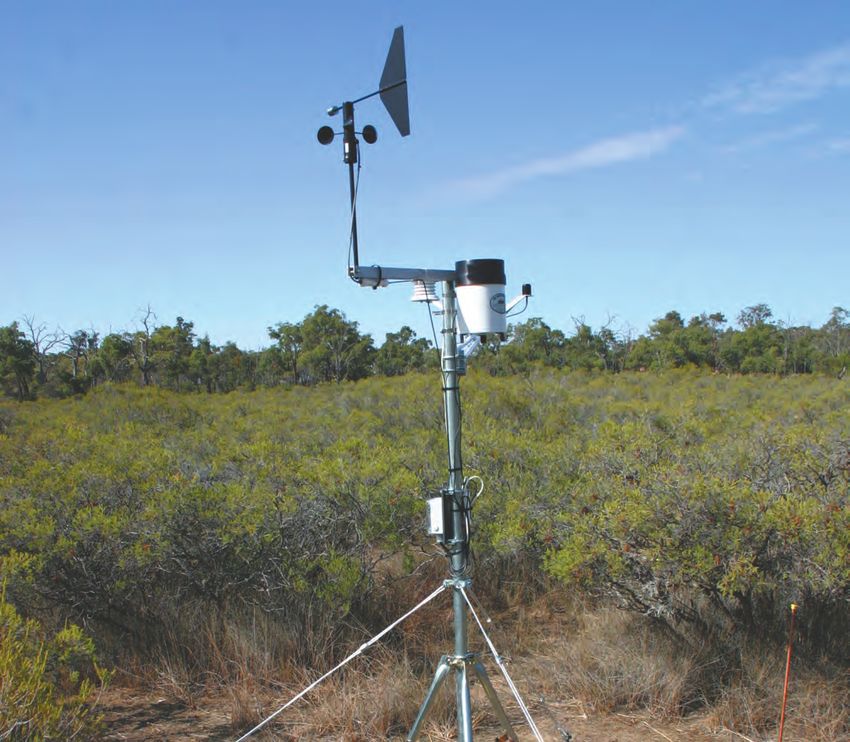
management triggers and limits of acceptable change.                                The threat of salinity to biodiversity
Limits of acceptable change are the limits within which
                                                                                    The expansion of salinity is changing significant areas
change to biodiversity assets can be tolerated in the
                                                                                    of the Western Australian (WA) agricultural landscape.
context of the goal and related values. Management
                                                                                    Salinity poses a serious issue for agricultural production
triggers lie inside the boundaries of acceptable change and
                                                                                    and is also a threat to biodiversity, affecting the survival
are intended to provide an early alert so that an adaptive
                                                                                    of native species and their communities. The use of the
management response can be implemented if required.
                                                                                    term ‘salinity’ in this report refers to secondary salinity as
Given the short period over which data are available,
                                                                                    opposed to ‘primary salinity’, which is naturally occurring,
both sets of indicators can be expected to change as new
                                                                                    such as in salt lakes predating European settlement.
knowledge becomes available.
                                                                                    The state government developed the Western Australian
This plan will be implemented through annual operational
                                                                                    Salinity Action Plan (Government of Western Australia
planning and works by the recovery catchment team. It
                                                                                    1996) in response to the increasing threat of secondary
will include annual reporting on expenditure and outputs,
                                                                                    salinity. This plan identified salinity in the south-west
and progress reports addressing the monitoring targets.
                                                                                    of WA as one of the state’s most critical environmental
Major reviews of the recovery plan will also be undertaken
                                                                                    problems. The plan was subsequently updated through
periodically.
                                                                                    the publication of Natural Resource Management in
                                                                                    Western Australia, The Salinity Strategy1 (State Salinity
                                                                                    Council 2000) and Salinity: A New Balance, Government’s
1 Salinity, biodiversity and the role                                               Response to the Salinity Taskforce report2 (Government
of recovery catchments                                                              of Western Australia 2002).3 In their review of the current
                                                                                    and potential extent of salt-affected land, McFarlane
The Drummond Catchment was designated as a natural
                                                                                    et al. (2004) estimated that WA has the largest area of
diversity recovery catchment (NDRC) in 2001 as part of the
                                                                                    secondary salinity in Australia and was also at the greatest
Natural Diversity Recovery Catchment program. The aim
                                                                                    risk of further salinisation over the next 50 years.
of this program is to focus government and community
actions to protect regionally significant, high priority                            McFarlane et al. (2004) estimated that about one million
biodiversity assets, especially wetlands, threatened by                             hectares of the state was affected by salinity and this was
salinity.                                                                           increasing at 14,000 hectares per year. The area with
                                                                                    salinity hazard4 was estimated to be between 2.9 and
The recovery plan for the Drummond NDRC (DNDRC):
                                                                                    4.4 million hectares. Most of this (about 80 per cent) is
•    identifies the priority cultural values of biodiversity 		                     on cleared agricultural land but also includes important
     assets threatened by salinity in the catchment                                 public assets such as biodiversity, water resources and
•    sets goals for biodiversity conservation based on these                        infrastructure (McFarlane et al. 2004; George et al. 2005).
     cultural values                                                                Recent work on groundwater trends in the wheatbelt
                                                                                    indicates that groundwater levels, in comparison with
•    identifies the most important biodiversity assets that
                                                                                    the preceding decades, have generally been more stable
     must be managed to achieve the specified values and
                                                                                    since 2000, with some areas showing downward trends
     related goals
                                                                                    (George et al. 2008). However, salinisation has continued
•    identifies the ecosystem processes that threaten goal 		                       to ‘expand in all regions, especially following episodic
     achievement and proposes a series of management 		                             floods, such as those that occurred in 1999–2000, 2001
     actions to address these threats                                               and 2006’ (George et al. 2008, p. 3).
•    establishes a framework for monitoring management                              The south-west of WA5 is an important area for
     actions and evaluating progress                                                biodiversity. The region has been recognised as one of the
•    documents the planning and priority-setting processes                          world’s 34 biodiversity hotspots based on the very high
•    serves as an implementation guide for catchment 		                             terrestrial species endemism combined with a high level
     managers, landholders and the community.                                       of vegetation clearing (that is, 30 per cent or less of the
                                                                                    original vegetation remaining) (Mittermeier et al. 2004).
                                                                                    The south-west of WA has 5,710 plant species of which
                                                                                    about 3,000 (53 per cent) are endemic (Mittermeier et al.
                                                                                    2004).
1.
   Usually referred to as the Salinity Strategy.
2.
   Usually referred to as the Response to the Salinity Taskforce Report
3.
  Throughout the remainder of this document, these reports are referred to as the Western Australian Salinity Action Plan, Salinity Strategy
and Response to the Taskforce Report respectively
4.
  Areas at risk from salinity because groundwater is predicted to rise close to the surface.
5.
  Throughout this document the south-west of WA refers to the area lying to the south and east of a line connecting Kalbarri and Cape Arid east of Esperance.

                                                                               5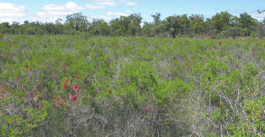
A key project funded through the Western Australian                                  • Increased erosion can cause the loss of topsoil and
Salinity Action Plan (Government of Western Australia                                  produce deeply incised drainage channels. Potential
1996) was the wheatbelt biological survey (1997–2001)6                                 undesirable impacts of increased erosion include poor
which documented biota in the south-west agricultural                                  slope stability and high rates of vegetation mortality in
zone and the extent to which it is threatened by salinity                              drainage lines due to exposure of roots.
(Keighery et al. 2004). This survey revealed that salinity
                                                                                     • Increased sedimentation, a by-product of excessive
has already had a significant impact on the native plants
                                                                                       erosion, can result in accelerated rates of sediment
and animals of the wheatbelt, particularly those species
                                                                                       deposition downstream. This in turn can cause turbidity
inhabiting wetlands. It was estimated that 450 plant
                                                                                       and alter flow regimes.
species and 400 species of fauna could be at risk of global
or regional extinction (Keighery et al. 2002a, 2004). Of                             • Increased salinity and other changes in water quality.
particular concern is that most wheatbelt wetlands have                                Increased input of salts may result in undesirable
already been severely degraded and these changes have                                  impacts to biota. The nutrients phosphorus and
been largely undocumented.7 The wheatbelt biological                                   nitrogen may lead to eutrophication and algal blooms.
survey substantially increased the knowledge of the                                    Decreases or depletion in ions, such as potassium,
impacts of salinity on biodiversity.                                                   calcium or magnesium, can also cause environmental
                                                                                       conditions to become intolerable for some biota.8 For
Secondary salinity and altered                                                         example, native aquatic snails cannot survive where
hydrology                                                                              chemical conditions prevent them from producing
As research has progressed and understanding has                                       shells.
improved, it is now apparent that secondary salinity is                              The current, general trend of a drying climate, in turn,
just one of the many complex effects that have arisen                                is compounding the above impacts by directly affecting
from altered hydrology in the Australian landscape. In the                           catchment water budgets. While some impacts may
south-west, altered hydrology has resulted from changes in                           be reduced under a changed climatic regime, there is
the water balance due to the removal of perennial native                             currently not enough information to confirm this. For
vegetation (high water users) and its replacement with                               example, if summer rainfall was to increase, salinity and
annual crops and pastures (low water users). Along with                              other problems arising from altered hydrology may be
the increase in salt-affected areas, other adverse impacts                           exacerbated.
of altered hydrology may include:
                                                                                     The term ‘secondary salinity’ implies that salt is the
• Changes in the area, distribution, frequency and timing
                                                                                     only problem. Therefore, ‘altered hydrology’ is a more
  of inundation in wetlands. Negative environmental
                                                                                     appropriate term, as it encompasses the entire suite of
  impacts, independent of water quality, may relate to
                                                                                     complex processes that has followed anthropogenic
  plant health and recruitment, and aquatic invertebrate
                                                                                     modifications to south-west landscapes. Impacts of altered
  survival.
                                                                                     hydrology can threaten the survival of native species,
• Increased waterlogging, through increases in soil                                  their biological communities and ecosystems. Effective
  water content, regardless of the quality of the water.                             management depends on understanding the physical
  Vegetation higher in the landscape and fringing                                    characteristics of an area, as well as the plant and animal
  wetland vegetation may also be affected.                                           tolerances and thresholds to hydrological and associated
                                                                                     changes.
• Changes in acidity and alkalinity, including elevated
  levels of acidity (low pH) or depletion in buffering
  capacity. While acidity itself can cause decline/mortality                         Natural Diversity Recovery Catchment
  of native flora and fauna, metals and other pollutants                             program
  that are also associated with acidic water can have                                The NDRC program is a commitment by the state
  additional negative environmental effects. It should                               government arising from the Western Australian Salinity
  be noted that, although less common, increases in                                  Action Plan (Government of Western Australia 1996). The
  alkalinity (high pH) can also have undesirable effects.                            objective of the program is stated as:

6.
  The major publication from the wheatbelt biological survey was A biodiversity survey of the Western Australian agricultural zone by Keighery et al. (2004). The
survey area ‘extended from the 600mm annual rainfall isohyet inland to the eastern edge of land clearing which approximately equates with the 300mm isohyet’.
7.
  A broad picture of changes due to salinity is provided by the oral history work of Sanders (1991) and the depth and salinity monitoring work by Lane et al.
(2009).
8.
  Precipitation of gypsum (CaSO4) due to increased input of SO4 from catchment drainage can deplete a waterbody of calcium and impact on macroinvertebrates
and gastropods. Plants are also susceptible to changes in the ionic content of water.

                                                                               6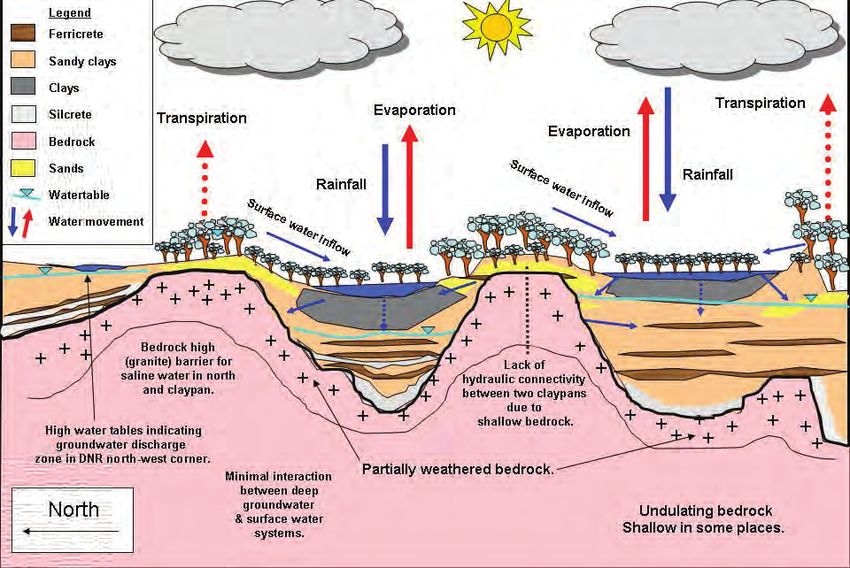
The government will develop and implement a coordinated                           and the Muir-Unicup Wetland Complex. A further three
 wetlands and natural diversity recovery program targeting                         NDRCs have been established since the inception of the
 at least six key catchments over the next 10 years to                             program: Lake Bryde, Buntine-Marchagee and Drummond.
 ensure that critical and regionally significant natural areas,
                                                                                   The first three NDRCs were selected prior to the
 particularly wetlands, are protected in perpetuity.
                                                                                   completion of the wheatbelt biological survey (Keighery et
 While not specified, the intent was to select catchments                          al. 2004). It was judged important to identify and begin
 threatened by altered hydrology, particularly salinity.                           to manage areas where high biodiversity values coincided
 Reviews of the state government’s salinity programs have                          with significant threats from altered hydrology, particularly
 reconfirmed the importance of the NDRC program and,                               salinity. The selection of the later NDRCs (Lake Bryde,
 where appropriate, have proposed its expansion (State                             Buntine-Marchagee and Drummond) was informed by
 Salinity Council 2000; Frost et al. 2001; Wallace 2001;                           the preliminary results of the wheatbelt biological survey
 Government of Western Australia 2002).                                            (Keighery et al. 2004).
 The NDRC program provides one focus for government                                As an interim measure, a set of criteria was developed for
 and community actions to manage the impact of salinity                            identifying recovery catchments (Appendix 1):
 on biodiversity in the south-west agricultural region. In
                                                                                   • biodiversity values at risk from altered hydrology
 designated catchments, it aims to conserve representative
 biological communities and their related physical diversity,                      • biogeographic representation
 together known as ‘natural diversity’.9 The focus of the                          • opportunities for research and development or
 program has been on selecting assets that represent the                             demonstration
 range of biodiversity threatened by salinity. Responsibility
                                                                                   • tenure of land at risk
 for the NDRC program resides with the WA Department of
 Parks and Wildlife (DPaW).10                                                      • representation of hazard

 NDRCs are one of two types of existing recovery                                   • potential for success (note that local community
 catchments, the other being water resource recovery                                 support was an important element assessed in this
 catchments (potable water resources) managed by the                                 regard)
 Department of Water. There has been useful cross-agency                           • sociopolitical considerations.
 support across these two programs.
                                                                                   The nomination document Proposed Drummond Nature
                                                                                   Reserve Natural Diversity Recovery Catchment (Department
 Priority setting for salinity actions
                                                                                   of Conservation and Land Management 2001) (Appendix
 To guide resource allocation to protect high value assets                         2), cited the following criteria in recommending the
 threatened by salinity the WA State Salinity Council                              catchment for recovery planning:
 commissioned the development of the Salinity Investment
                                                                                   • Drummond Nature Reserve, and specifically the
 Framework (SIF) in 2000. This study recognised that
                                                                                     claypans in the reserve, represent an important
 it is crucial to have a rigorous framework for ranking
                                                                                     biological community predicted to be at risk from
 salinity investments by governments given the extent
 and consequences of salinity and the very high cost of                              altered hydrology
 management. The recommended approach to priority                                  • occurs in a biogeographic zone not represented by
 setting is described in two reports: Salinity Investment                            other NDRCs—located on the north-east boundary
 Framework: Interim Report Phase I (Department of                                    of the Jarrah IBRA Region and the western edge of
 Environment 2003) and Salinity Investment Framework                                 the Avon Wheatbelt IBRA Region,11 the vegetation is
 Phase II (Sparks et al. 2006). The assets evaluated were:                           transitional, containing elements of several systems,
 biodiversity, agricultural land, water resources, rural                             many at the edge of their range
 infrastructure and social amenities. The selection of NDRCs
                                                                                   • potential to be a demonstration catchment
 precedes the Salinity Investment Framework processes,
                                                                                     representative of the many small-to-medium-sized
 but the relevant work is picked up in the Investment
                                                                                     reserves that occur on the east of the forest belt from
 Framework.
                                                                                     Bolgart to Cranbrook, which have high conservation
 Three NDRCs were established in 1996 under the Western                              values (for example wetlands and wandoo woodlands)
 Australian Salinity Action Plan (Government of Western                              threatened by salinity
 Australia 1996). These were Lake Warden, Toolibin Lake                            • model for undertaking, evaluating and costing

 This document is concerned with the conservation of natural biodiversity rather than domesticated species and other biodiversity arising from human actions.
9.

10
  On 1 July 2013, the Department of Parks and Wildlife was created following the separation of the Department of Environment and Conservation..In July 2006,
a reorganisation of some government departments resulted in the Department of Conservation and Land Management becoming part of the new Department of
Environment and Conservation. 11.IBRA: Interim Biogeographic Regionalisation for Australia, see http://florabase.dpaw.wa.gov.au/help/ibra/

                                                                              7
biodiversity actions for similar reserves where local                         The DNDRC Advisory Committee has met seven times
      effects and remedies are considered to be the means to                        between 2003 and 2011 to discuss progress and provide
      overcome the salinity issues                                                  input to the development of the recovery plan. Initially, the
                                                                                    advisory committee considered objectives and strategies.
• requires solutions that seek to achieve sustainable
                                                                                    The focus then moved to catchment research but also
  agriculture and increased water use on agricultural
                                                                                    included some ‘no-regret’ activities.12
  lands in the catchment, aspects which are of mutual
  interest to landholders and DPaW                                                  Planning and on-ground work to date have focused on the
                                                                                    following:
• important educational values—situated close to
  Perth, with catchment issues and solutions that are                               • Hydrological assessments, survey work and ongoing
  comparatively easy to demonstrate.                                                  monitoring to provide the basis for effective
                                                                                      management and planning.
The recommendation that the DNDRC be established was
endorsed by the Conservation Commission of WA, the                                  • Decreasing the flow of excess (surface and ground)
State Salinity Council (since disbanded) and the Minister                             water affecting biodiversity assets through revegetation.
for Environment (WA) in 2001. The catchment was the                                   These plantings also expand, buffer and link significant
sixth NDRC to be established and was officially launched in                           remnant vegetation within the greater DNDRC.
September 2003.                                                                     • Protecting remnant vegetation as part of hydrological
The selection of recovery catchments is now structured                                management.
around a more quantitative approach. A formal analysis                              • Research into biodiversity indicators for evaluating
using data generated by the wheatbelt biological survey                               management effectiveness. This has included testing
(Keighery et al. 2004) has been used to determine which                               the effectiveness of remote sensing tools for monitoring
other areas of the wheatbelt might best complement the                                change in vegetation condition, and trials of ecosystem
existing NDRCs (Walshe et al. 2004). This information                                 monitoring techniques for assessing resource condition
has been combined with the results from the Salinity                                  trends in managed (revegetated) and unmanaged sites
Investment Framework to select potential recovery                                     (Tongway and Hindley 2004).
catchments for the future.
                                                                                    • Alternative farming practices aimed at increasing water
                                                                                      use in the catchment, including salt-tolerant pastures,
Planning process                                                                      oil mallees and sandalwood.
The process used to develop this recovery plan is                                   • Building an appropriate culture to support biodiversity
summarised in Figure 1. While there is a logical and linear                           conservation.
sequence to this process, in practice it is iterative and
                                                                                    Within DPaW, a technical advisory group (TAG) has
interactive. It also involves input and consultation from the
                                                                                    provided planning guidance. This represents senior
community, particularly (in this case) the DNDRC Advisory
                                                                                    management, scientists and recovery catchment officers.
Committee and the Avon Nature Conservation Advisory
                                                                                    One of the roles of this committee is to provide technical
Committee.
                                                                                    and management advice on the development and
The DNDRC Advisory Committee is the main forum to                                   implementation of recovery catchment plans. This includes
facilitate work with the catchment community. Members                               advising the management team on the planning and
represent the following stakeholders:                                               feasibility of management actions. A wide range of other
                                                                                    stakeholders have also been involved to date (Appendix 3).
• catchment group – Land Conservation District
  Committee of Solomon-Yulgan                                                       The process for review and approval of recovery plans
                                                                                    includes internal review by the TAG as well as input
• local government – councillors from shires of Toodyay
                                                                                    from the project management team and the advisory
  and Victoria Plains
                                                                                    committee. This process is iterative and assists in refining
• government agencies – DPaW, Department of Water                                   goals and actions, and developing an evaluation and
  (DoW) and Department of Agriculture and Food                                      monitoring plan. Community input and support have
  (DAFWA).                                                                          been sought for this recovery plan through the advisory
                                                                                    committee prior to publication and release.

  No-regret activities are on-ground works that are required for longer term success, but may or may not be the most urgent in the short to medium term. These
12.

provide a sound basis for early on-ground action while investigations and more detailed planning occur. They also provide an important mechanism for engaging
the local community.

                                                                              8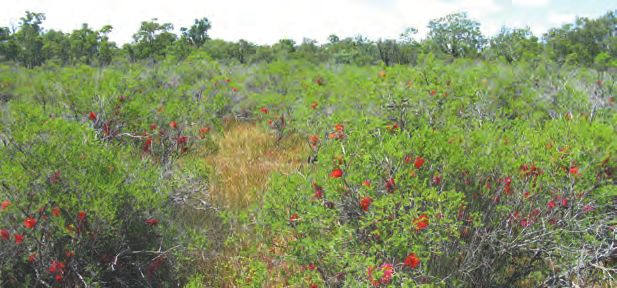
DPaW District staff at a claypan in Drummond
                                                                             Nature Reserve.
                                                                             Photo – Ken Wallace.

                      Establish cultural values: explore and identify the cultural
                      values of biodiversity assets threatened by altered hydrology.

                           Develop a catchment-specific goal: based on the
                           specific cultural values of biodiversity in the area –
                           set spatial and temporal scale as part of the goal.

                             Define the biodiversity assets: the biological
                             entities required to achieve the goal.

                             Describe key processes affecting the assets:
                             the key processes are described along with the
                             probability of them causing goal failure.                       a) Feedback
 b) Review
                                                                                             How do
                                                                                             How
 Are goals
 Are goals being
            being
                                                                                             constraints  affect
                                                                                             constraints affect
 achieved?
 achieved? Is                Determine feasibility of management: evaluate                   feasibilty?
 Is management               the feasibility of managing the key processes and               feasibility? Is
 management                                                                                  Is management
 effective?                  achieving the goal for the biological assets taking
                                                                                             management
                                                                                             efficient?
 effective?                  into account:
                                • knowledge and technical capacity to manage                 efficient?
                                • cost
                                • socio-political support.

                            Implement management actions: in partnership
                            with the community and other stakeholders.

                       Monitor and evaluate: re-evaluate goals and
                       conceptual/numerical models. Amend as necessary.

                               Outcome: achieve aspirational and/or
                               operational goal.

Figure 1 The planning and management process for natural diversity recovery catchments

                                                                9
2 Description of the Drummond NDRC
Planning area
The DNDRC extends across the two shires of Victoria Plains and Toodyay, and the administrative areas are described in Table 1.
Table 1 Overview of the administrative areas of the DNDRC
Local government shires Victoria Plains
Toodyay
DPaW administrative regions Swan Region, Perth Hills District
Wheatbelt Region, Avon-Mortlock District
Land tenure Freehold – 80% of area, about 58 landholders
DPaW-managed land – 6%
Bindoon Army Training Area – 11%
Other tenure – 3%
Catchment overview each). These claypans are unique to the wheatbelt as they
The DNDRC covers an area of 37,866 hectares, are the last remaining wetlands of their type in uncleared
approximately 100 kilometres north-east of Perth and land this far east. They contain one species of declared rare
about 10 kilometres west of Bolgart (Attachment 1, flora (DRF) and seven species of priority flora. Two other
Appendix 4). The catchment spans about 22 kilometres DRF species and 10 priority flora species have also been
from north to south and 16 kilometres from east to recorded in the reserve. Two of the valley floor vegetation
west, and consists of three subcatchments: Yulgan communities—wandoo woodland over dense low sedges
Brook, Solomon Brook and Mt Anvil Gully. The DNDRC community and the freshwater claypan community—are
is within the larger catchment of Toodyay Brook, and rare in the agricultural zone. The presence of the latter
more widely, the Avon River. The catchment is a long- community in DNR defines its eastern limit, as it is more
established farming area with 29 per cent remaining as commonly found on the Swan Coastal Plain (Department
remnant native vegetation (11,034 hectares) comprising of Conservation and Land Management 2001).
five nature reserves and part of a sixth; parts of the Julimar
Conservation Park (proposed) and Bindoon Army Training Social and economic characteristics
Area; plus on-farm remnants.13
At the 2006 Census, the combined population of the
The management focus within the DNDRC is two relatively shires of Toodyay and Victoria Plains was 5,015 people.
undisturbed freshwater claypan wetlands situated within The catchment itself is a sparsely populated agricultural
DNR, which is 439 hectares and a class ‘A’ nature reserve area, with less than 380 people14 and approximately 58
(Reserve No. 42808), vested with the Conservation farming properties (Kay 2001). It is a well-established
Commission of Western Australia for the purpose of rural community with many second and third generation
‘conservation of flora and fauna’. It was privately owned farmers in the district. Broadacre farming is the dominant
and part of a neighbouring farm before it was gazetted industry. Clearing native vegetation for agriculture
in 1993. DNR is located in the north-west corner of the began in the 1830s but expanded significantly with the
Toodyay Shire, on the watershed between the Solomon completion of the Toodyay-Bolgart Railway in 1909 (Kay
Brook and Mt Anvil Gully catchments, in the mid to upper 2001). In the north-west of the catchment, clearing was
part of those catchments (Department of Conservation still occurring into the 1990s (Department of Conservation
and Land Management 2001). and Land Management 2001). Currently, the main farming
DNR has very high biodiversity values, mainly focused on enterprises are cereal, legume and oilseed cropping,
the two seasonal claypan wetlands (about three hectares followed by meat and livestock production.15
13.
Calculations by Geographic Information Services Section, DEC, Kensington. April 2009.
14.
Australian Bureau of Statistics. Based on statistics relating to two Census Collector Districts (5040113 and 5041402) within which the catchment is located.
15.
ABS, www.abs.gov.au/ausstats, accessed April 2006.
10The towns closest to the catchment, Bolgart to the east Bolgart, the short-term average (1986–2008) is 10 per
and Calingiri to the north, are typical of small townships cent lower than the long-term average (1906–2008) (Table
in the WA agricultural zone. These towns have a range 2). However, the record for Bolgart is incomplete with
of infrastructure and services, including primary schools, data missing for the years 1971–82 and 1985. Hence, the
hotels, sporting facilities, general commercial shops, short-term average was calculated from 1986–2008.
agricultural suppliers and grain bulk-handling facilities. The
Table 2 Annual rainfall total averages at Bolgart
local government centre is located at Calingiri.
Period Average annual rainfall (mm)
Cultural heritage 1906–1970 474.5
The district holds significant cultural heritage relating to 1986–2008 411.8
both Aboriginal—spanning thousands of years (Ballardong
n.d.)—and settler cultures since the early years of the 1906–2008 458.1
Swan River Colony (Erickson 1971, 1974). There are two
Aboriginal language groups relating to the catchment
Regional geology, geomorphology and soils
area: the Juat in the western section and the Ballardong
in the eastern.16 Three Aboriginal cultural heritage sites of The majority of the DNDRC is underlain by a granitic
significance have been identified on private property on basement of varying depth. This basement outcrops at
the catchment’s eastern side. These are registered with the the surface regularly across all of the sub-catchments. In
Department of Indigenous Affairs.17 places, the granitic basement is intruded by dolerite dykes.
There is no evidence of any major palaeochannels in the
Two other heritage sites have been recorded in the
catchment. The granitic basement has been subjected to
catchment. There is an Aboriginal gnamma within DNR
a range of geological processes including: glaciation, deep
and there are settlers’ ruins dating back to the 1860s
weathering and laterisation resulting in a granitic regolith
within the Bewmalling Nature Reserve. Old Plains Road
profile that overlies this basement in many areas. Bedrock
was the route used by early settlers to drove flocks of
has been weathered in situ to form a regolith profile
sheep from Toodyay to grazing grounds at the Moore River
which consists of four main lithologies or regolith units:
in the mid to late 1800s (Western Australian National Parks
saprolite located immediately above bedrock; the clay-
and Reserves Association 1986). DNR is named after the
rich pallid zone; patchy discontinuous silcrete; and laterite
first government botanist, naturalist and explorer, James
or ironstone, both of which may be semi-impermeable.
Drummond (1784–1863) who lived at ‘Hawthornden’,
The distribution and properties of these units can be very
Toodyay. It is thought that Drummond would have
important for both local and regional hydrogeological
travelled and made botanical collections along Old Plains
regimes. In many areas, the regolith profile is capped by
Road.
more recent Quaternary sediments and soils derived from
weathering and reworking of regolith material. Distinct
Physical characteristics variation in soils is evident across the catchment, varying
Climate between gravels, clays and silts with occasional sands.
The DNDRC experiences a Mediterranean climate, with Hydrology and hydrogeology
mild wet winters and hot dry summers. Mean maximum
The hydrological boundary of the greater DNDRC is
daily temperatures range from 17 degrees Celsius in July to
defined according to the surface water catchment. The
34 degrees Celsius in January. Evaporation exceeds rainfall
DNDRC comprises three sub-divisions or sub-catchments:
for at least 10 months of the year, with June and July the
the Solomon Brook Catchment, Yulgan Brook Catchment
only months when rainfall is consistently likely to exceed
and the Mt Anvil Gully Catchment (Attachment 1,
evaporation.18
Appendix 4). The catchments’ main tributaries drain east-
Average rainfall across the catchment ranges between southeast into Toodyay Brook, which in turn flows south
650 millimetres and 400 millimetres per year, generally to the Avon River. Most stream flow within DNDRC is
decreasing from west to east. Bureau of Meteorology ephemeral; however, the lower section of Toodyay Brook
rainfall stations are located at Bolgart and a short distance has minor flows perennially. Groundwater flow direction
to the west, at Wattening.19 The average annual totals for generally mimics topography and surface water drainage
both these stations show a slightly declining trend. For within the DNDRC.
16.
http://www.dia.wa.gov.au/Documents/Maps/maps%20sept09/Tindale.pdf
17.
http://www.dia.wa.gov.au/AHIS/
18.
Based on data from Bureau of Meteorology, using evaporation data for Goomalling (closest station to DNR with data) and comparing it to rainfall data for
Bolgart and Wattening, which are further west than Goomalling and have higher annual rainfall.
19.
Bureau of Meteorology (http://www.bom.gov.au/climate/data/weather-data.shtml)
11Several main aquifer systems have been identified
3 Biodiversity values and
within DNDRC, including weathered bedrock (deep
regolith), alluvial, aeolian sand plain and infill valley basin
management goals
(Kay 2001; PPK 2002). Deep regolith aquifers occur
throughout the upper and middle catchment. These are Cultural values and biodiversity
characterised by brackish to saline groundwater and conservation
highly variable hydraulic conductivities, ranging from poor DPaW’s statutory functions are the key drivers for
in the shallow pallid zone to good in the saprolite zone, departmental management of biodiversity and
which directly overlies the bedrock. Aeolian sand plain conservation lands and, in a legal sense, circumscribe
aquifers are common in the upper catchment, as infill the operational activities of the department. However,
of depressions along valley flanks (mainly Solomon and to guide management, it is important to describe the
Yulgan catchments) and valley floor settings. These sand cultural values of biodiversity conservation in the DNDRC.
plain aquifers are typified by freshwater qualities and high This information is important both for setting goals and
hydraulic conductivities with ephemeral discharge common describing biodiversity assets. These values explain why
on the downgradient side. The unconfined alluvial aquifer biodiversity conservation is considered important in this
dominates the valley floors of the middle catchment area. catchment and for what purposes biodiversity is being
Generally, depth to groundwater is shallow (less than conserved.
five metres), hydraulic conductivities are good and water Individuals and groups within any community have a
quality is variable. The infill valley basin aquifer occurs range of motivations for conserving biodiversity. For
along a north-south trending line in the middle catchment effective natural resource planning and management, it is
area, comprising mainly sandy sediments (and some clays); important to clarify the dominant cultural values within the
it infills the basement hollows above the main tributaries. particular situation (Shields et al. 2002; Wallace 2006). The
These discontinuous aquifers vary between being confined relevant cultural values can then be used, provided they
and unconfined across the greater DNDRC. Water quality are consistent with the department’s legislated functions,
ranges from fresh to saline; hydraulic conductivities to underpin the catchment goals and definition of specific
and yields are often high. It should be noted that there biodiversity assets for conservation, and drive decision-
is evidence of the possible existence of fractured rock making for management actions. The classification system
aquifers within the lower reaches of the DNDRC, in for cultural values developed by Wallace (2006) has been
particular the Mt. Anvil Catchment. The location of these adapted for this plan.
will be defined by structural control and will be difficult to
The DNDRC Advisory Committee met in June 2008 to
utilise due to highly variable yields.
determine the relative importance of the various cultural
DNR is situated in the upper reaches of the DNDRC and values delivered from biodiversity threatened by altered
straddles the boundary between the Solomon and Mt hydrology within the DNDRC. The steps in this process
Anvil catchments. It is dominated by shallow outcrops were as follows:
of bedrock and ironstone intermixed with deep regolith 1 All the biodiversity assets considered to be at risk
aquifers, infilled valley sand aquifers and sand plain of altered hydrology were described. Note that,
aquifers, all of varying depths. The extent and connectivity depending on the values analysis, not all of these
of these aquifers are determined to a certain degree by assets may be a priority for management.
the location of the bedrock highs. Groundwater flow is
2 The eight cultural values (see below) were defined and
generally west to east through DNR, although it can be
discussed.
impeded and sometimes diverted in areas of the bedrock
highs. The two pristine, fully vegetated freshwater claypans 3 Committee members ranked the values anonymously
in DNR are situated within topographic depressions in the in relation to the biodiversity assets described in (1).
south-west and north-east corners of the reserve. Both The results were combined to rank the values from
claypans are relatively impermeable and are surrounded the collective perspective of the committee. The
by highly conductive, sandy sediments. Localised surface committee represents key communities of interest,
water flows tend to concentrate towards these two including the state community (through agencies
claypans during the winter rain events. For a more detailed representing biodiversity, water and agriculture) and
explanation of DNR’s hydrological characteristics, refer to local communities of interest.
Forbes and Vogwill (2010). 4 The top three ranked values were accepted as the
priorities for planning processes. (Appendix 5).
12The cultural values identified, in order of priority were: values were the most vulnerable to salinity and therefore
of highest importance. Although this differs from the
1 Scientific and educational values—focused on
advisory committee’s top three ranked values, it is likely
scientific investigations that advance knowledge of
that the specific set of biodiversity assets required in each
salinity management, and the broader contribution to
case will overlap significantly. This issue is explored further
education and training. The advisory committee ranked
in the section below dealing with selection of priority
this value as the most important and identified that the
biodiversity assets.
biodiversity assets of the catchment are an educational
resource for local land-holders, school groups and the
broader (state) community. DNDRC was also identified
The goal of the Drummond NDRC
as a case study for environmental management and as The goal of the DNDRC is:
a benchmark for measuring change, including of the To deliver the scientific and educational values, opportunity
historical value of biological communities. values and system benefits values derived from the current
2 System benefits values—from maintaining the (2011) composition and structure of biodiversity assets of
catchment and downstream environment. In relation to the DNR threatened by altered hydrology for the next 20
managing altered hydrology, these potentially include years.
flood mitigation, nutrient stripping and salt storage. This goal focuses on biodiversity assets that were predicted
The advisory committee ranked this category second, to be at risk due to altered hydrology at the time of the
based on the premise that the wetland assets are establishment of the DNDRC. This prediction is explored
highly connected to downstream environments. More further in Section 5. The goal is constrained in space and
recent work suggests these benefits are likely to be time, setting clear boundaries for asset management
limited, although there is some hydrological connection and timeframes for monitoring. Spatial and temporal
with environments downstream. For this reason the dimensions are also required so that the threatening
value has been retained. processes and feasibility of achieving the goal can be
assessed. The specific biodiversity assets required to deliver
3 Opportunity values—based on the range of potential
the goal are determined in Section 4.
future opportunities represented in the biodiversity
assets. These might include genetic resources or water The spatial scale of the goal is the boundary of the
resources yet to be harvested. The advisory committee specified broad asset types within DNR. These areas are
identified that conserving the full range of native taxa part of the wider DNDRC (Attachment 1, Appendix 4).
in the biodiversity assets protected opportunities for This aspect of the goal is in line with Proposed Drummond
future human benefit. Nature Reserve Natural Diversity Recovery Catchment
(Department of Conservation and Land Management
4 Amenity values—including aesthetic values, such as the
2001). The nomination document focused on DNR and, in
scenic values of natural landscapes, as well as shade
particular, the freshwater claypans and other biodiversity
and shelter values. Amenity values help maintain a
assets therein, which were predicted to be at risk from
sense of place.
altered hydrology. This plan maintains that focus but
5 Philosophical/spiritual/intrinsic values—are a strong recognises that with time it could broaden to include
driver for biodiversity conservation at the state and assets within the wider recovery catchment area.
local level.
The temporal scale for this document is 20 years. This is a
6 Recreation values—including opportunities for tourism compromise between the long duration of some natural
and recreational use for activities such as bushwalking, cycles (in some cases over 100 years) and our ability to
picnicking and birdwatching. plan with reasonable certainty. In addition, it is expected
that while positive outcomes from recovery works will be
7 Consumptive use values—natural resources harvested
achieved in the short term, major achievements will occur
for non-commercial, domestic use. Potentially, this
over longer timescales, but within the next 20 years.
could include seed collection from the reserve,
with appropriate approvals, for off-reserve land or While the WA Salinity Strategy goal for NDRCs refers to
biodiversity conservation work. biological and physical diversity, the goal for the DNDRC
is directed only at biological values. Actions required
8 Productive use values—not relevant here in relation to
to conserve biological assets threatened by salinity are
biodiversity assets.
expected to also protect physical diversity. For example,
At a state level, the Salinity Investment Framework Phase management of erosion and sedimentation will contribute
II (Sparks et al. 2006) recognised that opportunity values, to the protection of both wetland biological communities
system benefits values and philosophical/spiritual/intrinsic and wetland geomorphology.
13Sustainable land use goal • Partnership programs between local landholders,
DPaW and DoW to trial innovative invasive weed
Projects in recovery catchments provide opportunities
control programs with the aim of returning infested
to test and develop methods for combating salinity that
paddocks to productive pastures.
may be applicable throughout the south-west agricultural
region. This was recognised in the review of DPaW salinity In turn, these activities are expected to contribute to:
programs (Wallace 2001) and in the Toolibin Lake Recovery • understanding important principles in managing saline
Plan (Toolibin Lake Recovery Team & Toolibin Lake Technical lands with similar geomorphology
Advisory Group 1994), where three of the principal goals
• developing economically viable and biodiversity
relate to sustainable land use. This acknowledges that
beneficial solutions for water management
the most efficient way of achieving biodiversity goals is to
undertake works on farmland that address hydrological • increasing agricultural productivity
and other threats to conservation values. Ultimately, • delivering the priority cultural values outlined in this
agricultural solutions need to be economically viable if they recovery plan.
are to be adopted.
As such, a secondary goal in recovery catchments, Responsibilities and ownership of goal
including DNDRC, is: implementation
To contribute to the development of technologies to It is DPaW’s responsibility to implement management
combat salinity throughout the agricultural region. actions to achieve the goals of this recovery plan. DPaW
has a statutory responsibility for managing biodiversity
Nonetheless, the management priority in NDRCs is always in WA and is the lead agency in the NDRC program.
protecting biodiversity assets threatened by salinity. This is reflected in state government policy such as the
Maintaining biodiversity assets may not be a major focus WA Salinity Strategy. DPaW is accountable, through the
for many land-holders in the DNDRC, but developing Minister for Environment (WA), to the WA community for
environmentally sensitive technologies that combat delivering biodiversity conservation outcomes. The DNDRC
salinity and support more sustainable, economically viable Advisory Committee does not have any direct responsibility
agriculture is of mutual interest. For example, limiting for implementation of the recovery plan, although it has
the spread of salinity and waterlogging benefits both strong ownership of the goal and management actions
agricultural industries and biodiversity conservation. described.
Sustainable land use will be explored through research Factors affecting ownership and implementation of
and development, management, demonstration and recovery plan actions include:
monitoring activities. Activities are underway in the
• Landholder support of actions on private land. Most
catchment to: protect biodiversity, develop technologies
of the land (80 per cent) in the DNDRC is private
to combat salinity, and provide immediate benefits to
property and many recovery actions will require the
catchment land-holders. These activities contribute to
cooperation of relevant land-holders. Achieving the
on-farm water and stock management and include the
goal of the plan will therefore depend on support
following:
received from a number of catchment land-holders.
• A joint DAFWA, DNDRC and Forest Products Thus, the management actions proposed for farmland
Commission ‘Sustainable Grazing of Saline Lands’ trial will need to satisfy the economic and other goals of
project 2005. This project aimed to establish perennial land-holders. Management actions that meet the goals
pastures on saline land and to stabilise the degradation of all partners will best integrate land use and recovery
of remnant woodland. catchment activities.
• Continuing work on developing new commercial • Land-holder support for biodiversity conservation. The
industries based on mallee eucalypts in the catchment advisory committee indicated that support for the goals
and elsewhere in the south-west, including planting of of the DNDRC plan relies, at least in part, on continued
oil mallee plantations to act as vegetation buffers for DPaW investment within the wider recovery catchment
DNR. (DNDRC Advisory Committee meeting minutes, 26 July
2006). This underlines the importance of maintaining,
• Fencing to protect native vegetation from stock grazing
as far as practicable, activities that benefit both the
and revegetation of conservation areas.
recovery goal and local land-holders in general. One
• Establishing sandalwood plantation demonstration example of such activity is the DPaW contribution
sites. to the management of spiny rush in the catchment,
which benefits all catchment managers.
14You can also read


