North West Regional Plan - planning for a stronger, more liveable and sustainable community
←
→
Page content transcription
If your browser does not render page correctly, please read the page content below
North West Regional Plan
                                                                       North West
                                                                       Regional Plan
                                                                       planning for a stronger, more liveable
                                                                       and sustainable community
                                                                       August 2010

Department of Infrastructure and Planning
PO Box 5666 Townsville QLD 4810
tel +61 7 4799 7379
fax +61 7 4760 7535
northwest@dip.qld.gov.au

www.dip.qld.gov.au/northwest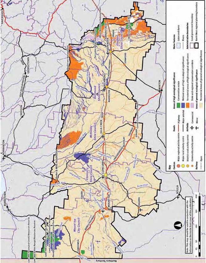
North West Regional Plan                         Disclaimer: This document is produced to        Release notes
                                                 convey general information. While every
2010-2031                                                                                        The North West Regional Plan 2010-2031 is
                                                 care has been taken in preparing this
(NW Regional Plan)                               document, the State of Queensland accepts       released by the Minister for Infrastructure
                                                 no responsibility for decisions or actions      and Planning under the Sustainable
Prepared by:                                     taken as a result of any data, information,     Planning Act 2009, section 769 and the
Prepared by the Honourable Stirling              statement or advice, express or implied,        repealed Integrated Planning Act 1997,
Hinchliffe MP, Minister for Infrastructure and   contained within. The contents of this          section 2.5A.15. It is a statutory instrument
Planning in accordance with the Integrated       document were correct to the best of our        under the Statutory Instruments Act 1992.
Planning Act 1997, section 2.5A 10.              knowledge at the time of publishing.
                                                                                                 The regional plan does not commit or
With assistance from:                            Any reference to legislation contained within   pertain to commit any government,
Department of Infrastructure and Planning.       is not an interpretation of the law. It is to   organisation, industry or community
                                                 be used as a guide only. The information        organisation to implement, fund or
In consultation with the:                        contained within does not take into             otherwise resource specific activities or
North West Regional Coordination                 consideration any reference to individual       programs.
Committee.                                       circumstances or situations. Where
                                                 appropriate independent legal advice should     For more information on the regional plan,
Published by:                                    be sought.                                      contact:
                                                                                                 Department of Infrastructure and Planning
                                                 All maps are intended to represent general      post     PO Box 5666 Townsville Qld 4870
                                                 concepts for the purpose of broad-scale         visit    Level 4 State Government Building
                                                 regional planning. These maps do not,                    187–209 Stanley Street Townsville
                                                 and are not intended to identify, or give       tel 		   +61 7 4799 7379
ISBN: 978–0–9804831–9–2                          attributes or rights, including land use        fax 		   +61 7 4760 7535
                                                 and development rights, to specific land        email northwest@dip.qld.gov.au
© The State of Queensland (Queensland            use parcels. Boundaries and locations           web      www.dip.qld.gov.au/northwest
Department of Infrastructure and Planning)       are indicative only, and may be subject
2010.                                            to further refinement. The Department           Copies of the regional plan are available:
                                                 of Infrastructure and Planning does not         online www.dip.qld.gov.au/northwest
The Queensland Government supports and           guarantee, or make any representations          for viewing at most council chambers,
encourages the dissemination and exchange        as to the accuracy or completeness of the       libraries and customer service centres within
of information. However, copyright protects      information shown on these maps, nor does       the local government areas covered by the
this document. The State of Queensland           it accept any responsibility or liability for   regional plan
has no objection to this material being          any loss or damage arising from its use.        for free collection on CD-ROM or in
reproduced, made available online or                                                             hard copy by contacting Department of
electronically but only if it is recognised as   The Queensland Government is committed          Infrastructure and Planning offices in
the owner of the copyright and this material     to providing accessible services to             Townsville, Mount Isa and Brisbane
remains unaltered. Copyright inquiries about     Queenslanders from all culturally and           by phoning +61 7 4799 7379
this publication should be directed to the       linguistically diverse backgrounds. If you      by emailing northwest@dip.qld.gov.au
Crown Copyright Administrator via email,         have difficulty understanding this document
crown.copyright@qld.gov.au or in writing to      and need an interpreter, please call the        Department of Infrastructure and
PO Box 15168, City East, Queensland 4002.        Translating and Interpreting Service            Planning offices:
                                                 (TIS National) on 131 450 and ask them to       •	Level 4, corner of Walker and Stanley
                                                 telephone the Queensland Department of              Streets, Townsville
                                                 Infrastructure and Planning on                  •	Level 1, Mount Isa House,
                                                 07 3227 8548.                                       Cnr Camooweal and Mary Streets,
                                                                                                     Mount Isa
                                                                                                 •	Level 2, Orchid Plaza, 79-87 Abbott
                                                                                                     Street, Cairns
                                                                                                 •	Shop front, 63 George Street, Brisbane.

                                                                                                                      ISB 978-0-9804831-9-2
                                                                                                                      RPN_0181_02_Pu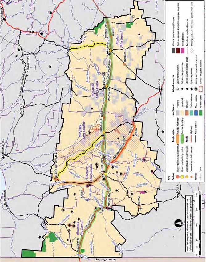
North West Regional Plan
2010—2031
planning for a stronger, more liveable
and sustainable community

North West region vision—the North West region
has a robust, diverse and sustainable economy
and well-planned and coordinated infrastructure
and services, built through the economic benefits
of mining and agricultural industries. It is a place
where people choose to live and visit due to its
liveability, well-managed natural resources and the
community’s strong sense of cultural identity.
2                                                                                                                                               North West Regional Plan

Contents
Map 1—North West Queensland locality map........................ 4                            3.1 		     Education and learning..............................................35
Part A—Introduction................................................................ 5         3.2		      Social planning and social infrastructure..................36
Background and purpose.........................................................5              3.3        Social services...........................................................38
Working with other plans and strategies................................6                      3.4        Regional lifestyle, cultural heritage and arts............38
Inter-regional coordination.......................................................6           3.5		      Promoting health and wellbeing...............................40
Preparation...............................................................................7   3.6		      Leadership, networks and coordination.................... 41
Application, implementation and review.................................7                      4		        Urban development...................................................42
Structure of the regional plan..................................................8             4.1		      Urban structure and settlement pattern....................42
                                                                                              4.2		      Urban design, character and form.............................43
Part B—Regional vision.......................................................... 9            4.3		      Housing mix, affordability and design......................44
                                                                                              4.4		      Hazard mitigation.......................................................45
Part C—Strategic directions...................................................10              5		        Economic development..............................................47
Creating a more sustainable future....................................... 10                  5.1 		     Business, industry and land development................48
Protecting regional landscapes and supporting regional                                        5.2        Diverse regional economy.........................................48
production values................................................................... 10
                                                                                              5.3		      Innovation, knowledge and technology....................49
Creating liveable communities................................................11
                                                                                              5.4		      Employment, skills development and
Promoting a dynamic, robust and diversified economy.........11                                           staff retention............................................................49
Providing infrastructure and services......................................11                 5.5		      Agriculture.................................................................. 51
Integrating land use, economic activity and transport                                         5.6        Mining and mineral processing................................. 51
infrastructure...........................................................................11
                                                                                              5.7		      Tourism.......................................................................53
Adapting to climate change................................................... 12
                                                                                              5.8		      Marketing...................................................................54
Managing mining growth........................................................ 12
                                                                                              6		        Infrastructure..............................................................55
                                                                                              6.1 		     Infrastructure planning and coordination..................56
Part D—Regional activity centres network.............................13
                                                                                              6.2        Energy........................................................................56
                                                                                              6.3        Transport....................................................................58
Part E—Regional strategies and policies...............................18
                                                                                              6.4        Water infrastructure................................................... 61
1		        Natural environment.................................................. 19
                                                                                              6.5        Waste management...................................................62
1.1		      Biodiversity conservation...........................................20
                                                                                              6.6        Information and technology......................................63
1.2 		     Pest, plant and animal management........................22
1.3 		     Scenic amenity and outdoor recreation....................23
                                                                                              Part F—Implementation, monitoring and review.................. 64
1.4 		     Air and noise emissions............................................23
1.5 		     Greenhouse gas emissions........................................25
                                                                                              Region maps 2 to 6.............................................................. 67
2		        Natural resources.......................................................26
                                                                                              Appendix 1—mineral exploration maps................................ 72
2.1		      Land and natural resource use and management....27
                                                                                              Glossary................................................................................. 74
2.2        Water management and use......................................27
                                                                                              Abbreviations......................................................................... 76
2.3        Mining and extractive resources................................29
                                                                                              Bibliography.......................................................................... 76
3		        Strong communities................................................... 31
                                                                                              Acknowledgments.................................................................. 78
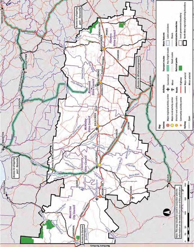
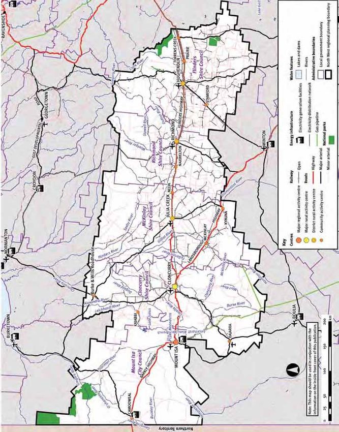
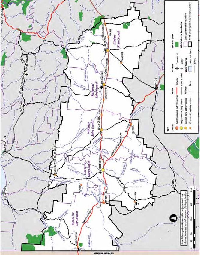
4                                                                                                                                                                                North West Regional Plan

Map 1—North West Queensland locality map

Disclaimer: The information on this map should be treated as indicative only and subject to ongoing refinement. Based on or contains data provided by the State of Queensland (Department of Environment and
Resource Management) 2008. In consideration of the state permitting use of this data you acknowledge and agree that the state gives no warranty in relation to the data (including accuracy, reliability, completeness,
currency or suitability) and accepts no liability (including without limitation, liability in negligence) for any loss, damage or costs (including consequential damage) relating to any use of the data. Data must not be used
for direct marketing or be used in breach of the privacy laws. Data source: Department of Environment and Resource Management and Department of Infrastructure and Planning.

Part A–Introduction                                                                                       5

Part A—Introduction

Background and                   The regional plan applies to the North
                                 West region, which includes the local
                                                                               The North West is characterised by
                                                                               diverse and spectacular natural features,
purpose                          government areas specified in                 including savannah and upland country,
                                 schedule 1, part 3 of the Sustainable         world-class fossil deposits and national
                                 Planning Regulation 2009.                     parks. It is the source of numerous river
The North West is one of the                                                   systems and has five bioregions, some of
largest regions in Queensland,   The region (Map 1, page 4) includes the       which are home to endangered flora and
                                 following:                                    fauna.
covering more than 200 500
                                 • Flinders Shire
square kilometres—stretching                                                   People who live and work in the North
from the Northern Territory      • Richmond Shire                              West face a number of opportunities and
                                                                               challenges, including:
border in the west to the        • McKinlay Shire

Great Dividing Range in the      • Cloncurry Shire                             • managing the cyclical nature of mining
                                                                                 industry development in a way that
east. It has a strong and        • Mount Isa City.
                                                                                 complements other industry sectors in
proud multicultural heritage,                                                    the region
                                 With an estimated population of
with a significant population    approximately 28 7001, 21,5792 people         • responding to new market
of Indigenous people.            live in Mount Isa City, with the balance of     opportunities
                                 residents living in other shires.             • encouraging economic diversity to
                                                                                 maintain balanced growth, especially in
                                 Mining and mineral processing contribute        agriculture
                                 significantly to the regional and national
                                 economy. The region has globally              • providing social and economic
                                 significant mineral resources, including        opportunities to encourage people to
                                 over one quarter of the world’s known           remain in or return to the region
                                 lead and zinc reserves. Mineral extraction    • meeting growing energy and water
                                 and processes generate significant wealth       demands
                                 for the region and the nation. Although
                                                                               • managing potential long-term
                                 home to less than one per cent of the
                                                                                 population decline in the non-mining
                                 state’s population, the region’s mining
                                                                                 parts of the region
                                 activity contributes significantly to the
                                 state’s revenue. Agriculture, particularly    • adapting to increase cost of oil
                                 beef production, is also a significant          products (peak oil)
                                 primary industry, with a long history in      • adapting to long-term uncertainty
                                 the region.                                     regarding climate change
                                                                               • attracting and retaining skilled workers
                                                                                 and residents
1 ABS Cat. No. 3218.0 (2008)                                                   • developing strategic guidance for
2 ABS Cat. No. 3218.0 (2008)                                                     infrastructure provision
6                                                                                                                             North West Regional Plan

• supporting increased economic                             The bibliography (page 77) provides                         The regional plan also influences the
  opportunities in eastern shires                           information about the Queensland and                        preparation of community plans under
                                                            Commonwealth policies and documents                         the Local Government Act 2009. The
• positioning the region to take
                                                            referred to in the plan.                                    Local Government (Finance, Plans and
  advantage of renewable energy
                                                                                                                        Reporting) Regulation 2009 stipulates
  resources
                                                                                                                        that a local government community plan
• accessing and providing essential
  services to smaller centres.                              Planning period                                             must identify local and regional issues
                                                                                                                        that effect, or may in the future affect,
                                                                                                                        the local government area. Consequently,
The Queensland Government developed                         The North West Regional Plan provides                       a strong link exists between a regional
the Blueprint for the Bush3 initiative                      the framework for integrating federal,                      plan and community plans.
and Rural Economic Development and                          state and local government planning
Infrastructure Plan4 to respond to rural                    agendas, linking infrastructure and service
issues.                                                     provision to manage future population
                                                            change to 2031.                                             Inter-regional
The North West Regional Plan (the regional
plan) is an essential mechanism for                         The regional plan also considers the
                                                                                                                        coordination
managing change and shaping the future                      region’s potential needs beyond 2031
prospects of rural and mining communities                   to ensure that planning decisions made                      Due to its extensive transport networks,
in the region by:                                           today do not compromise options to                          traditional associations and strategic
                                                            meet longer-term needs. The regional                        location, the North West region has
• addressing key economic, social and
                                                            plan addresses long-term issues such as                     strong links with communities in the Gulf
  environmental issues
                                                            climate change and infrastructure needs.                    region and eastern parts of the Northern
• identifying infrastructure and service                                                                                Territory, Townsville and the southern
  needs                                                                                                                 parts of Queensland, as well as the
                                                                                                                        southern states.
• maximising benefits and managing
  impacts of major projects
                                                            Working with other
• driving innovation and productivity                       plans and strategies                                        The plan does not directly influence the
                                                                                                                        planning processes or regulate the use
• mobilising public, private and                                                                                        of land in areas outside the North West
  community sectors                                         The desired regional outcomes of the                        region. It is important however, that the
                                                            regional plan cannot be achieved through                    potential cross-regional planning issues
• aligning efforts across agencies and all                  land use planning mechanisms alone.                         be considered in a broader planning
  levels of government.                                     Implementation of the strategies and                        context.
                                                            actions of other plans are critical to
The regional plan, whilst meeting some of                   achieving the region’s vision.
the government’s Blueprint for the Bush
commitments, is also part of a wider                        The Northern Economic Triangle
process—ensuring that a consistent and                      Infrastructure Plan 2007-2012 (the NET
contemporary regional land use planning                     Infrastructure Plan) is recognised in the
framework is operating across all of                        regional plan as an important instrument
Queensland.                                                 for developing the region through the
                                                            emergence of Mount Isa, Townsville
                                                            and Bowen as a triangle of mineral
Glossary and                                                processing and industrial development.
                                                            Other regional planning initiatives in the
bibliography                                                North West region include the Southern
                                                            Gulf Catchments and Desert Channels
                                                            Queensland natural resource management
The glossary (page 74) defines particular
                                                            plans. Statutory plans include the Water
words used in this regional plan. Other
                                                            Resource (Gulf) Plan 2007 and the Water
terms used in this regional plan have
                                                            Resource (Great Artesian Basin) Plan
the meaning given in the Sustainable
                                                            2006.
Planning Act 2009 (SPA).

3 Blueprint for the Bush is a 10-year plan to build a strong rural Queensland of sustainable, liveable and prosperous communities.
4Q
  ueensland Government, AgForce Queensland and the Local Government Association of Queensland, 2006, Blueprint for the Bush: Rural Economic Development and
 Infrastructure Plan. Queensland Government, Brisbane.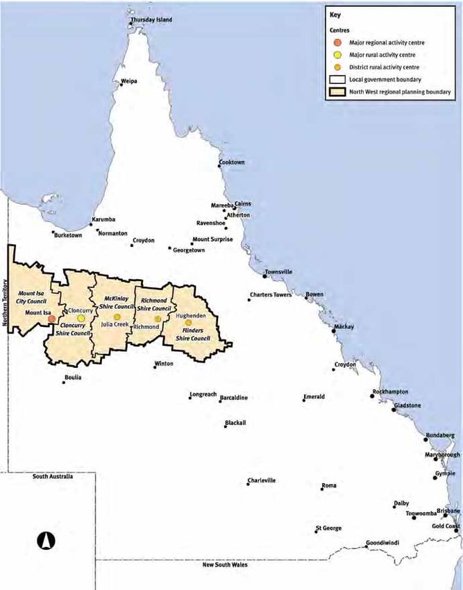
Part A–Introduction                                                                                                            7

Preparation                                                                                      Where a planning scheme conflicts with
                                                                                                 the regional plan, the regional plan
                                                                                                 prevails (section 26(3) of SPA).
The regional plan has been developed
with extensive advice from the North West                                                        The regional plan is not supported by
Regional Planning Committee (previously                                                          state planning regulatory provisions in
known as the North West Regional                                                                 relation to land use.
Coordination Committee) which was
established under section 2.5A.3 of the                                                          The following parts of the regional
Integrated Planning Act 1997. The role of                                                        plan are relevant when assessing a
the committee has been to:                                                                       development application or a master plan
                                                                                                 application against or having regard to the
• provide advice to the Minister on
  regional planning matters
                                                Application,                                     regional plan:

• assist the preparation, implementation        implementation and                               • the regional activity centres network
                                                                                                   and narratives in Part D
  and review of the regional plan               review                                           • regional strategies and policies in
• facilitate the resolution of regional
                                                                                                   Part E.
  planning issues                               The regional plan is a statutory
• promote a coordinated approach to             instrument under the Statutory
                                                                                                 An application conflicts with the regional
  regional planning.                            Instruments Act 1992 and a planning
                                                                                                 plan if it does not comply with the
                                                instrument under the Sustainable
                                                                                                 regional activity centres network in Part
The Regional Planning Committee                 Planning Act 2009 (SPA). The regional
                                                                                                 D or the regional strategies and policies
(RPC) is an inclusive forum of regional         plan provides the broad framework for
                                                                                                 in Part E.
stakeholders, appointed by the Minister,        addressing priority issues in the North
who have looked beyond individual               West region for the next 20 years to             The regional plan directs state agencies,
interests to highlight matters of regional      ensure that planning decisions do not            through Queensland Government-agreed
significance to be addressed through the        compromise longer-term planning needs.           strategies, policies and programs and is a
regional plan.                                                                                   key tool of Qplan, Queensland’s planning,
                                                If a local government is preparing a
                                                                                                 development and building system. The
The draft regional plan was made available      planning scheme, it must take into
                                                                                                 regional plan allows a region to achieve
for public comment for a minimum                account the regional plan. This must
                                                                                                 a sustainable planning foundation,
period of 60 business days in accordance        be done by stating within the planning
                                                                                                 and provides strategies and policies to
with section 2.5A.13 of the Integrated          scheme how the scheme will reflect the
                                                                                                 manage growth and change at a regional
Planning Act 1997. The regional plan has        regional plan (section 26(2) of SPA). Local
                                                                                                 level as shown in Figure 1.
been prepared in good faith, taking into        governments are also required to amend
account all public submissions, to provide      their planning schemes to reflect the
a framework for the management and              regional plan (section 29 of SPA).
development of the region.

Figure 1. My Street. Our State

 Legislative and policy framework                                Strategic outcomes and deliverables          Infrastructure
 Towards Q2
 State Development and Public                                                                                 State infrastructure plans
 Works Organisation Act 1971               Our state                         Gateway upgrade project          and priorities
                                                                           Northern Economic Triangle         Regional infrastructure
 North West Regional Plan 2010-2031            Our region                           Infrastructure Plan       delivery programs
                                                                                                              Local infrastructure
                                                                     Finders Shire Planning Scheme,           planning and delivery
 Sustainable Planning Act 2009                         My town       McKinlay Shire Community Plan            programs
                                                                                                              Neighbourhood
                                                                                                              infrastructure programs,
                                                                                                              location-specific
 Petroleum Act 1923                                        My local area     Nordale Industrial Estate        infrastructure
                                                                                                              Site-specific standards of
 Building Fire Safety Regulation 2008                                  My street            Smart eDA         service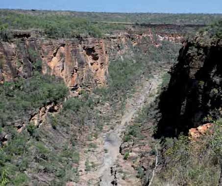
8                                                                                                    North West Regional Plan

The statutory regional planning
framework provides for a formal, state-
                                             Structure of the
wide monitoring and review process           regional plan
across the state which is an important
element in any regional land use planning    Part A Introduction—provides background
framework—see Figure 2. The outcomes                material to establish the context
and policies of the regional plan will be           and intent of the regional plan.
monitored and used in the formal review             It also outlines the need for the
of the regional plan. A formal review will          regional plan and its relationship
be undertaken at least every ten years.             with other planning processes and
Notwithstanding the above, the Minister             instruments.
can amend the regional plan at any time
under SPA.                                   Part B Regional vision—outlines the
                                                    desired future for the North West
Figure 2. Regional plan flowchart                   region.                               The information sources used to prepare
                                                                                          these maps may vary, with respect to scale,
                                             Part C Strategic directions—sets down        accuracy and currency.
                                                    the broad policy framework for
         North West                                 the regional plan.                    The Department of Environment and
        Regional Plan                                                                     Resource Management has prepared
                                             Part D Regional activity centre networks     mapping showing areas of ecological
                                                    and subregional narrative—            significance. The maps have been prepared
                                                    characterises townships, their        from high quality data sets of terrestrial
                                                    facilities and services. Narratives   vegetation, key threatened species’ habitats,
       Part A—Introduction
                                                    indicate the strategic intentions     and wetlands. Given the size of the region,
                                                    for towns in the North West region    the scale used in the regional maps should
                                                    and will guide local planning,        only be used as general information.
                                                    location and coordination of
     Part B—Regional vision                         services.                             More detailed information on the region’s
                                                                                          areas of ecological significance is available
                                             Part E Regional strategies and policies—     from the Department of Environment and
                                                    provides the planning principles      Resource Management website. The maps
                                                    and guidelines for managing           in the regional plan are not regulatory maps
    Part C—Strategic directions                     future land use, development          and are used as information guides.
                                                    and protection of the North West
                                                    region. They should be reflected      Strategies are designated with a letter of
SPA planning       Aligned planning                 in all relevant plans, policies and   the alphabet. For example, strategy
 mechanisms           mechanisms                    codes being prepared or amended       3.4.A Promote and celebrate the region’s
                                                    by the Queensland Government          cultural and artistic diversity is found in:
                                                    or local governments in the North
     Part D—Regional activity                       West region, including planning       Part E—Regional strategies and policies
          centres network                           schemes and community plans.          Topic 3—Strong communities
                                                                                          Subtopic 4—Regional lifestyle, cultural
                                             Part F Implementation, monitoring and        heritage and the arts
                                                    review—sets out the proposed          Strategy A
    Part E—Regional strategies                      governance arrangements for
           and policies                             implementing, monitoring and          The numbering system for the policies
                                                    reviewing the regional plan.          indicates their position in the plan. For
                                                                                          example, land use policy 3.4.1 Identify and
                                                                                          protect Queensland heritage places and
     Part F—Implementation,
      monitoring and review
                                             Maps                                         local heritage places in local government
                                                                                          planning schemes is found in:
                                             The regional plan is supported by six
                                             maps which provide spatial information to    Part E—Regional strategies and policies
                                             assist policy implementation and identify    Topic 3—Strong communities
                                             resources, values and areas of state         Subtopic 4—Regional lifestyle, cultural
                                             significance. The maps are based on best     heritage and the arts
                                             available data at the time of printing.      Policy number 1.
Part B–Regional vision 9
Part B—Regional
vision
The North West region The vision for the North West region The plan recognises that the region’s
defines the community’s long-term Indigenous and multi-cultural heritage will
has a robust, diverse and aspirations for the region and reflects the continue to define the region’s cultural
sustainable economy and environment the community desires to live identity. It also identifies the need for a
well-planned and coordinated in now and protect for future generations. well-educated community—one that offers
It was developed through contributions a broad range of education and career
infrastructure and services, from the Regional Planning Committee opportunities for residents, to meet the
built through the economic (RPC). It recognises the link between the region’s long-term growth needs.
benefits of mining and region’s prosperity and the continued
exploitation of mineral resources and The vision is the foundation of the
agricultural industries. It is regional plan. It informs the strategies
the need to invest in other industries to
a place where people choose provide an economically sustainable future. and policies to ensure the region’s natural
to live and visit due to its assets, social capacity and economic
The vision recognises that the long-term resources are managed and enhanced for
liveability, well-managed
prosperity of the region is reliant on future generations.
natural resources and the sound management of the region’s natural
community’s strong sense resources and the ongoing viability of
of cultural identity. mining and agricultural sectors.
The vision is consistent with the state-
wide ambitions of the Queensland
government’s blueprint for the future,
Toward Q2: Tomorrow’s Queensland,
which sets targets for Queensland’s future
which are to be achieved by 2020. This
vision is also consistent with the Northern
Economic Triangle Infrastructure Plan
2007–2012.10 North West Regional Plan
Part C—Strategic
directions
The regional plan proposes Creating a more various services they provide to
humans as well as their intrinsic values
a range of policies to
achieve its vision and
sustainable future • internalising environmental costs—
ensuring that the true costs and
desired outcomes for the A key strategic direction of the regional life-cycle costs (incurred from when
region which are based plan is to ensure economic development inputs are produced through to waste
is managed sustainably. The plan aims disposal) of protecting and restoring
on the following strategic
to protect biodiversity, support a viable environmental damage are reflected in
directions. settlement pattern, build and maintain the price of a product or service
community identity, improve transport and • engaged governance—ensuring broad
information technology and infrastructure, community involvement in decisions
and manage future demands for water and actions that affect them
and energy.
• precautionary principle—ensuring that
The Queensland framework for ecologically where there are threats of serious or
sustainable decision making5 has been irreversible environmental damage,
used to inform the development of a lack of full scientific certainty is
strategic directions, strategies and policies not used as a reason for postponing
in the regional plan. The framework measures to prevent environmental
comprises: degradation.
• integrated and long-term decision
making—incorporating long and short-
term environmental, economic and Protecting regional
social considerations
• intergenerational equity—ensuring the
landscapes and
health, diversity and productivity of the supporting regional
environment is maintained or enhanced
for the benefit of future generations production values
• intergenerational equity—ensuring a
North West Queensland is characterised
fair share of resources and opportunity
by distinctive rural and natural
among present generations
landscapes which support a range of uses
• conserving biological diversity and and provide significant environmental,
ecological integrity—protecting the economic, cultural and social benefits to
variety of all life forms, their genetic the region. This plan includes strategies
diversity and the ecosystem of which and policies to protect and manage the
they form a part, recognising the regional landscape values of the North
West region.
5 National Strategy for Ecologically Sustainable Development, ESD Sustainable Development Steering Committee, Commonwealth of Australia 1992.Part C–Strategic directions 11
Minerals are a significant economic
resource in the region and the plan
includes policies to protect and manage
the impacts caused by the exploitation of
these resources. Rural lands contribute to
the agricultural production of the region
and the plan sets strategies and policies
to protect these lands and encourages
sustainable practices.
In areas of the upper catchment of the
Flinders River, there are opportunities
for a sustainable irrigation area and to
build on existing irrigation farming. The
region includes water catchments and
areas of high ecological value that are
of regional significance and of state and
national significance. Strategies and
policies in the plan support existing
legislation that protects and provides
for the management of these ecological
resources. The regional plan supports mining
and rural production to ensure they
Integrating land use,
are not adversely affected by other economic activity
land use activities, while encouraging
Creating liveable diversification of the economy and the and transport
communities raising of productivity by addressing skills
gaps and shortages. Greater support
infrastructure
will be given to value-adding economic
The regional plan seeks to provide Quality of life and economic development
initiatives. This will be achieved through
positive land use and urban design opportunities for regional communities
the creation of strategic opportunities and
responses to the region’s communities. can be enhanced by access to an efficient
by improved planning and collaboration
These responses aim to protect the transport system. The plan integrates land
by government, industry and the
heritage character and improve the use and transport planning to:
community.
visual amenity of existing towns, while
• improve the efficiency of existing
maintaining and enhancing services in
transport networks
line with government and private sector
priorities. The network of regional activity Providing • influence future transport infrastructure
centres encourages the enhancement
of the larger activity centres to support
infrastructure and • explore opportunities to align transport
needs to land use to assist the region’s
smaller communities. services economic growth
• link dispersed regional communities.
The regional plan addresses infrastructure
Promoting a dynamic, and service requirements to meet the The plan recognises future transport
future and existing needs of North
robust and diversified West communities through the Northern
strategies must take into account the
impact of rising fuel prices on the cost of
economy Economic Triangle Infrastructure Plan
2007–2012. The regional plan supports
living in isolated communities, adapting
to climate change and competing funding
improved access to work places, essential priorities, as well as the need for better
The region’s economy, primarily reliant
services and recreation, and encourages access to national and international
on mining and agricultural production,
stronger connections throughout the markets.
contributes significantly to the regional
region to improve the liveability of
and national economy. It is recognised
regional communities. Water and energy On a national level, Australia no longer
that to ensure a sustainable future, the
capacity are recognised as limiting factors produces enough oil to meet the nation’s
region needs to work towards building a
to future regional development. needs. Australia and Queensland are
diversified economy.
therefore becoming more dependent12 North West Regional Plan
on imported oil and oil-based fuels,
which are affected by global supply and
Longer-term projections for the North
West Queensland region include an
Managing mining
demand. As in many parts of the world, overall decline in rainfall with increasing growth
North West communities and industries temperature, evaporation and an increase
rely on oil, making the region vulnerable intensity of rainfall events. This will
Growth in mining for base metals in the
to changes in the supply and price of oil. result in more extreme climate events,
North West region has the potential to
such as flooding, drought, bushfire and
produce state-wide social and economic
Through the ClimateQ: towards a cyclonic weather. Management of the
benefits for decades to come. However,
greener Queensland initiative, the regions’ agriculture and industry activities
it requires increased management of
Queensland Government is implementing are likely to be adversely affected by
environmental, social and economic
programs to encourage the uptake of the projected increases in temperature
impacts on communities and appropriate
fuel efficient vehicles and alternative and changing rainfall patterns. Table 1
mitigation strategies.
fuels. The Queensland Renewable Energy illustrates projected impacts.
Plan supports the use of renewable
The regional plan, in conjunction with the
energy sources as a means of reducing Toward Q2: Tomorrow’s Queensland sets
Northern Economic Triangle Infrastructure
dependence on oil and oil-based fuels. a target to cut Queenslanders’ household
Plan 2007–2012, the Sustainable Futures
greenhouse gas emissions from waste,
Framework for Queensland Mining
fuel and electricity by one-third by 2020.
Towns and the Sustainable Resources
Adapting to climate Regional climate change actions for the
North West will also be influenced by
Communities Policy released by the
state government in 2007 and 2008
change state-wide and national climate change
respectively, address these impacts
initiatives and policies, including the
through a range of strategies and
Queensland Government’s ClimateQ:
Scientific evidence overwhelmingly policies.
towards a greener Queensland.
indicates climate change will impact
on regional areas of Australia and this The strategies and policies focus on
The regional plan’s strategies and policies
demands an urgent response. Climate improving the gathering of quantitative
recognise the risks associated with
change is likely to compound the effects information about the mining industry to
climate change and the need to develop
of existing threats on the region’s support regional planning, address land
a research capacity to identify regionally
biodiversity, economy and liveability. use implications of individual projects,
specific implications and opportunities.
and build capacity and capability at a
The plan also recognises the need to
Research indicates significant economic local government level to help to manage
develop planning strategies to reduce the
benefits in responding early to climate these impacts.
region’s climate change vulnerability.
change—both to mitigate and adapt to its
effects. Early reduction of emissions and
adaptation to climate change will incur
less cost in terms of economic growth
and lifestyle.
Table 1. Specific climate change projections for the North West region
Variable Season 1971-2000 2030 2070
Current historical Medium scenario High scenario
mean (projected change) (projected change)
Temperature Annual 25.2 +1.1 (+0.7 to +1.5) + 3.4
Centigrade (C°) (+2.3 to +4.9)
Rainfall % Annual 534 mm -2 -5
(-11 to +8) (-31 to +24)
Potential evaporation % Annual 2775 mm +3 +9
(+2 to +4) (+6 to +14)
Data Source: Commonwealth Scientific and Industrial Research Organisation 2007 & Bureau of Meteorology 2008.
Regional summaries prepared by Queensland Climate Change Centre of ExcellencePart D–Regional activity centres network 13
Part D—Regional
activity centres
network
The regional activity centres The North West region has five types of activity centres:
network is a state-wide Major regional activity centres—centres generally servicing Mount Isa
framework used to describe catchments of regional significance and potentially areas
outside the designated region. These centres have key
communities in terms of concentrations of employment, business and major retailing
population, range and depth facilities and services. They have populations ranging from
of business and employment approximately 5000 to 20 000 residents.
types, educational facilities, Major rural activity centres—centres generally serving Cloncurry
service infrastructure, housing catchments of sub-regional to regional significance,
accommodating concentrations of employment, business,
and community facilities.
services, commercial and retail uses in remote areas of the
The regional activity centres network will state. The population range of these centres is typically
identify key locations for the provision between 2000 and 5000 residents.
of state government services and
District rural activity centres—centres providing essential Julia Creek,
infrastructure by:
functions at a district to sub-regional scale, often to a Richmond,
• identifying nodes for key economic and widely dispersed service population. They provide a range Hughenden
social services of goods and services for weekly shopping and may have
• identifying preferred growth locations a post office, pharmacy, grocery store or supermarket, bank,
to determine where infrastructure and hardware store, real estate office, hotel or motel, caravan
services should be located park and service station. The population range of these
centres is typically from 200 to 2000 residents.
• identifying the projected level of
service for each centre, assisting in the Community activity centres—centres with low resident Camooweal, Dajarra,
prioritisation and level of service populations and generally remote from larger centres. They Kajabbi,
provide limited services for locals and travellers. Typical McKinlay, Kynuna,
• identifying projected housing demand
services include service stations, small convenience stores, Nelia,
and key influences
hotels and camping areas. They typically have populations Maxwellton, Stamford,
• providing regional assessment criteria of less than 200 residents. Prairie, Torrens Creek
for planning applications.
Mining centres—specialist urban precincts supporting a Ernest Henry,
Map 2 (page 67) shows the regional regionally or nationally significant economic activity, such Cannington,
activity centres network for the North as a major mining operation. A mine site typically has a Eloise,
West region. These centres are significant mineral processing plant, power generators, maintenance Osborne,
places for economic activity and social and loading facilities, air strip, as well as administration Phosphate Hill,
interaction, with strong historical offices. Accommodation facilities may be located nearby Trekelano,
and cultural connections for regional or adjacent to the mine. Most of these facilities are self- Mount Gordon,
communities. contained and place limited demand on local services and Leichhardt Copper
infrastructure. In many cases, the local infrastructure has Operation,
been funded and built by the associated mine(s). Lady Annie14 North West Regional Plan
Centre narratives Economy and employment
Industry in the city is based around
Xstrata Mount Isa Mines. Other major
Mount Isa industries are cattle grazing and tourism.
Population in Mount Isa 2008: 20 684 (a) Mount Isa is recognised as a secondary
Population in Mount Isa City 2008: 21 570 (a) administration centre, supporting
administrative activities in larger regional
Indicative planning population in Mount Isa City 2031: 25 886 (b)
activity centres such as Townsville. It
has a wide range of local and state
Activity centre classification government services and several major
Major regional companies are based there. Mount Isa
services catchments of sub-regional
Major employers by industry (2006) (c)
to regional significance and is the
Mining 26.6% major service and supply centre for the
Retail trade 8.9% surrounding mining industry.
Health care and social assistance 8.6%
Mount Isa provides health services to
Education and training 8.2% rural and remote communities within
Construction 6.3% North West Queensland and surrounding
regions, including residents of the
Data source:
(a) Planning Information Forecasting Unit (PIFU), 2007, North West region population report
Northern Territory.
(b) PIFU, 2008 edition population projections (medium series)
(c) Office of Economic and Statistical Research (2010), Queensland Regional Profiles. The tourism industry is increasingly
important to the region’s economy. Events
Mount Isa is serviced by Queensland Rail’s passenger
train the Inlander, which travels overnight to
such as the Mount Isa rodeo, carnivals
and race days, and the city’s cultural and
Townsville twice a week in each direction. recreational facilities attract national and
With an estimated population of 21 570
international attention.
in 2008, Mount Isa City is the only major Located on the outskirts of the city
regional activity centre in the North West centre, the Mica Creek Power Station
region. Mount Isa is located within the supplies the local and surrounding area
North West Mineral Province, a world- with electricity. The power station is gas Industrial and residential land
class mining and minerals processing fired and has the capacity to generate up Mount Isa has land available for
precinct centred on Mount Isa, Bowen to 325 megawatts of electricity6. residential, commercial and industrial
and Townsville. Mount Isa is one of
development.
Queensland’s major mining hubs for The main supply of water for Mount
exploration, extraction and processing of Isa and its mining operations comes
base metals. from Lake Moondarra. This artificial lake
located on the Leichardt River can hold Community services
Mount Isa shares a boundary with 114 000 megalitres at full capacity7. Lake The city offers primary, secondary and
the Northern Territory to the west. Julius is another key source of water tertiary education with private and
Geographically, Mount Isa is the second which is also located on the Leichardt public schools, TAFE, university facilities
largest city (in area) in Australia. River. The East Leichardt Dam is a and apprenticeship opportunities,
potential source of water for the region including the Spinifex College which
however it is not currently utilised. has a residential campus. The city also
Infrastructure houses the Mount Isa School of Distance
Additional infrastructure has been Education which services the needs of
The city is a regional transport hub, identified as a key factor in increasing students to grade 10, and School of the
serviced by rail, road and commercial the lifespan of some mines in the region Air. Mount Isa has facilities for students
air networks providing transport services and stimulating the development of new with varying levels of special needs,
locally and interstate. The Barkly Highway small and mid-size mines. An expansion including an Education Queensland
is the main road transport route through of a range of infrastructure would support Special School.
the region, which links the Northern growth in the city, provide increased
Territory to north Queensland and the scope for the development and expansion
rest of eastern Australia. Mount Isa has a of other industries and strengthen the
taxi service with services to and from the local economy.
neighbouring centre of Cloncurry. The city
6 Mount Isa to Townsville Economic Zone 2009 Investment Guide.
7 Mount Isa to Townsville Economic Zone 2009 Investment Guide.Part D–Regional activity centres network 15
Growth opportunities and Cloncurry
key challenges
Population in Cloncurry 2008: 2607 (a)
Mount Isa is predicted to experience Population in Cloncurry Shire 2008: 3394 (a)
fluctuating growth over the next 20 years.
Indicative planning population in Cloncurry Shire 2031: 3208 (b)
However the city is expected to remain the
major service centre for the North West,
parts of the Central West and the Gulf Activity centre classification
region and the eastern Northern Territory Major rural
during the life of this plan. The city has
Major employers by industry (2006) (c)
the potential to expand its industry role
through continued exploration, processing Agriculture, forestry and fishing 16.6%
and value-adding activities. Transport, postal and warehousing 13.3%
Mining 13.2%
The overall sustainability of the city relies
heavily on future mining development. Public administration and safety 9.9%
Its ability to sustain additional mining- Construction 6.6%
related growth, ancillary industrial
Data source:
activities and provide services to other (a) Planning Information Forecasting Unit (PIFU), 2007, North West region population report
activity centres will largely depend on (b) PIFU, 2008 edition population projections (medium series)
the management and timely provision (c) Office of Economic and Statistical Research (2010), Queensland Regional Profiles.
of essential infrastructure and services,
and the availability and affordability of Community services Attracting and retaining mining staff
residential land and housing. Lowering and families remains a challenge for
the costs of electricity in the region and Cloncurry provides primary to year 12 the local community and government.
improving capacity of other infrastructure education and community and recreation Increasing the resident population will
could increase the viability of previously facilities to the sub-region. Queensland remain dependent on the provision
explored mineral deposits and extend the Health provides a range of primary of adequate infrastructure including
life of several operating mines. and secondary health services with roads, water, sewerage, residential
specialists available on a visiting basis. land and housing, as well as access
The town is also a strategic centre for to social services. The need to sustain
other government agencies, including the or increase the level of services in
Cloncurry Department of Transport and Main Roads. Cloncurry will depend on population
change associated with mining expansion,
With an estimated population of 3394 in the workforce arrangements of these
2008, Cloncurry Shire is the only major Growth opportunities and key industries and new mining developments
rural activity centre in the North West challenges in both Mount Isa and Cloncurry.
region. Cloncurry has a proud pioneering
history and is the birthplace of the Royal Over the next 20 years, Cloncurry has the
Flying Doctor Service and Queensland potential to grow through the expansion
School of the Air. of industries including fabrication and
construction. Some of the Ernest Henry
mine workforce is housed in the town.
Infrastructure Expansion and further exploration in
mineral processing is also probable, given
The town has good access to rail and the number of mineral reserves identified
road networks as well as government- to the north and south of the town.
subsidised air, long distance coach and
long distance rail services. Opportunities to develop and exploit
renewable energy resources such as solar
and geo-thermal may also present in the
Economy and employment future, providing energy for local and
possibly national networks.
Cattle and mining provide the economic
base for the town. The local mining Population growth will be influenced by
industry generates employment the workforce arrangements of mining
in associated industries including industries. Previous industry trends have
transport, manufacturing, construction, shown a prevalence of fly-in and fly-
accommodation and services. out work arrangements in the region.16 North West Regional Plan
Julia Creek Julia Creek, Richmond
Population in Julia Creek 2008: 377 (a) and Hughenden
Population in McKinlay Shire 2008: 961 (a)
Indicative planning population in McKinlay Shire 2031: 863 (b) Julia Creek, Richmond and Hughenden
are all classified as rural activity centres
in the North West region. Regional
Activity centre classification communities gather regularly in these
District rural centres to celebrate events including
Major employers by industry (2006) (c) the Dirt and Dust Festival in Julia Creek,
the Fossil Festival in Richmond and the
Agriculture, forestry and fishing 44.6%
Country Music Festival in Hughenden.
Mining 11.3% These shires sit on top of the Great
Public administration and safety 9.0% Artesian Basin, one of the largest ground
Construction 5.8% water basins in the world.
Retail trade 5.2%
Infrastructure
Located on the Flinders Highway and
Richmond Great Northern Railway line, these
Population in Richmond 2008: 554 (a) centres are local transport hubs. West
Wing Aviation provides both passenger
Population in Richmond Shire 2008: 950 (a)
and freight services from Mount Isa to
Indicative planning population in Richmond Shire 2031: 825 (b) Townsville. The Great Northern Railway
runs east-west from Mount Isa to
Townsville. This rail network is linked to
Activity centre classification
the eastern sea ports. The main source of
District rural
water is through the Artesian Basin.
Major employers by industry (2006) (c)
Agriculture, forestry and fishing 39.8%
Public administration and safety 11.3% Economy and employment
Transport, postal and warehousing 7.6% Julia Creek (estimated population of
Retail trade 6.7% 377) is the administration centre for the
McKinlay Shire, and Richmond (estimated
Health care and social assistance 6.5%
population of 554) and Hughenden
(estimated population of 1195) are the
administration centres for Richmond and
Flinders Shires respectively. These shires
Hughenden are largely covered by productive black
Populationin Hughenden 2008: 1195 (a) soils and high value Mitchell and Flinders
Population in Flinders Shire 2008: 1864 (a) grass. It is an important area for the
production of beef, for both domestic and
Indicative planning population in Flinders Shire 2031: 1718 (b) overseas markets. The BHP Cannington
Mine operates within McKinlay Shire, with
Activity centre classification the majority of its labour force being
District rural fly-in and fly-out workers8.
Major employers by industry (2006) (c) These centres have strong connections
Agriculture, forestry and fishing 35.8% with Townsville for processing and export
Transport, postal and warehousing 10.9% purposes.
Public administration and safety 9.4% Tourism in these centres is growing, with
Retail trade 7.4% visitors drawn by a range of attractions
Education and training 6.6% including the region’s national parks and
Data source:
(a) Planning Information Forecasting Unit (PIFU), 2007, North West region population report 8 Mount Isa to Townsville Economic Zone 2009
(b) PIFU, 2008 edition population projections (medium series) investment guide.
(c) Office of Economic and Statistical Research (2010), Queensland Regional Profiles.Part D–Regional activity centres network 17
fossil dinosaur attractions. Hughenden In Julia Creek there is potential for
and Richmond are well known as part of developing geothermal energy infrastructure
Australia’s Dinosaur Trail. Flinders Shire and opportunities for the development
covers a variety of diverse landscapes, of a transportation hub serving the shire
covering four bioregions. Amongst these and parts of the Gulf region. Richmond
bioregions are four National Parks. and Hughenden areas have potential for
irrigation farming and associated agricultural
industries. Tourism is also an area for
Community services expansion in terms of accommodation,
restaurants and cafes and there is potential
Each centre contains a small concentration for tour operators to utilise the diverse
of retailing business, professional services nature of the centres and adjoining regions.
and offices. Residents also access larger
centres outside of the region for higher
order goods and services. District rural
activity centres provide subregional Community activity
health and education services through
locally based professionals and facilities.
centres
Hospitals or health centres provide primary
and emergency services, while patients Camooweal, Dajarra, Kajabbi, McKinlay, Mining centres
requiring emergency specialists are Kynuna, Nelia, Maxwellton, Stamford,
evacuated by air. Specialists, ranging from Prairie and Torrens Creek are all classified
The Ernest Henry, Cannington, Eloise,
nutritionists to speech therapists regularly as community activity centres in the North
Osborne, Phosphate Hill, Trekelano,
visit the region. Education facilities range West region. While these centres have
Mount Gordon, Leichhardt Copper
from childcare to secondary schooling. fewer than 200 residents each and are not
Operation and Lady Annie mines are
designated rural localities according to the
recognised as specialist activities centres.
Racecourses, rugby, golf, netball, Australian Bureau of Statistics, they provide
These sites are located between 30 and
swimming and athletics are amongst the important localised essential services and
138 kilometres from major urban centres.
major sporting groups/facilities in these opportunities for social interaction.
centres. Hughenden has a multifunction The populations of these specialist
entertainment centre, which is used for The centres have very limited access to
activity centres are largely fly-in and
many events and functions including government services. Health services are
fly-out workers who commute from
hosting sporting activities. generally provided by visiting healthcare
regional and metropolitan centres.
professionals. Some towns such as
They are generally accommodated in
Camooweal, Dajarra, Stamford and Prairie
single person’s quarters located on
offer primary education. Some have
Growth opportunities and key community services such as police, a rural
or near mining leases. These catered
challenges accommodation arrangements usually
fire service and recreation facilities.
provide communal dining areas, canteens
Historical trends show these centres are and entertainment facilities. Medical
Community activity centres may provide
influenced by fluctuations in population, facilities are also provided on site and are
important focal points for transport
investment and employment due to generally staffed by registered nurses.
and tourism services and have facilities
commodity prices, resource demand, climate
such as racecourses and service
factors and availability of workers. Land Specialist activity centres are privately
stations. Many of the centres located
for commercial, industrial and residential owned and managed. The future of these
along the Flinders Highway and Great
development is available in all centres, centres is determined by the global
Northern Line were significant supply
including large urban blocks to semi-rural demand for metals, the rate of depletion
or distribution centres before transport
acreage that are available for development. of resources and exploration of new
networks were extended east to Mount
mineral deposits nearby. A number of
Isa and into the Northern Territory.
While these centres are likely to prospective sites are being explored in
experience only modest growth over the region, mostly in Cloncurry Shire,
The services provided in some of these
the next 20 years, an ageing population which may result in the emergence of
towns were established at times when
and household change will place a new specialist activity centres in the
they had higher populations. Some towns
different emphasis on service provision region. The size and location of these
exist because of a single industry or
priorities. Services within each centre will centres depends in part on their proximity
attraction. Population growth in these
need to be responsive to existing and to other centres, the affordability of
centres is not anticipated however, the
future community needs. Identification housing and liveability.
need to sustain existing services is
of different service delivery approaches
recognised. Different service delivery
may contribute to improved provision of
methods may be used in the future to
services to these centres in the future.
provide services to these centres.You can also read