DRAFT Parangarahu Lakes Area Co-Management Plan - and amendment to the GWRC Parks Network Plan
←
→
Page content transcription
If your browser does not render page correctly, please read the page content below
DRAFT Parangarahu Lakes Area
Co-Management Plan
and amendment to the GWRC Parks Network Plan

           He Taonga mo tatou
  Lakes & wetlands of national significance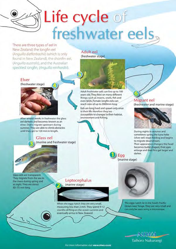
Mihi & acknowledgments by Roopu Tiaki
DRAFT Parangarahu Lakes Area Co-Management Plan
Members of Te Roopu Tiaki
Te Roopu Kaitiaki consists of three trustees of Port Nicholson Block Settlement Trust (PNBST) and three
senior officers from Greater Wellington Regional Council (GWRC).
Mark Te One Te Rira (Teri) Liz Mellish Tim Porteous Nigel Corry Amanda Cox
Puketapu
Manager General Manager Parks
Biodiversity Manager
Environment
PNBST Trustee PNBST Trustee PNBST Trustee GWRC GWRC GWRC
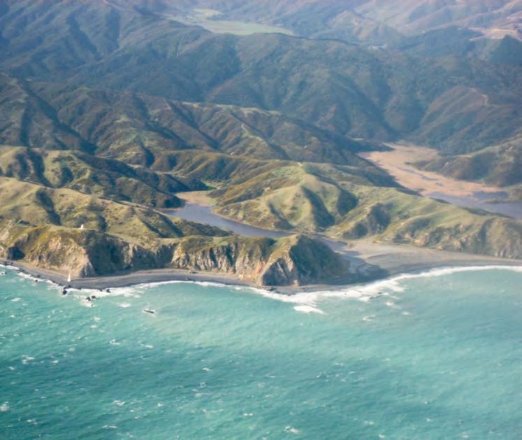
Cover Image: An aerial view of Pencarrow Lighthouse and the Parangarahu Lakes, looking northeast.
Aidan, http://www.flickr.com/photos/31909437@N00/2738703326
1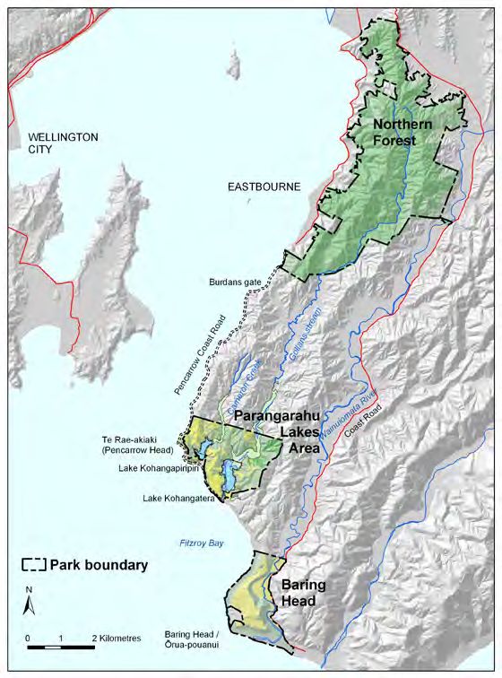
Executive Summary
                                                  The strength of a rope is in its many strands.              geological, ecological and cultural heritage features
                                                  This draft co-management plan is the result of              of the Parangarahu Lakes Area. For example,
                                                  the intertwining of multiple interest strands               based on a 2011 NIWA survey, the lakes are ranked
                                                  to develop a shared vision for preserving and               very highly on the national Lakes SPI index:
                                                  protecting the taonga of Lake Kohangapiripiri and           Lake Kohangatera’s condition is ‘excellent’ with
                                                  Lake Kohangatera and the broader Parangarahu                nationally outstanding botanical values, placing
                                                  Lakes area. The lakes and wetlands are an                   it at 10th ranking out of a total of 206 lakes; and
                                                  area of national significance and located along             Lake Kohangapirpiri’s condition is ‘high’ and
                                                  Wellington’s Southeast Coast adjacent to the main           ranked 47th. Notwithstanding these national
                                                  harbour entrance, nestled behind the distinctive Te         rankings, there are still risk, threats and issues to
                                                  Rae-akiaki (Pencarrow Head) where the historic              be addressed. Key risks to the ecological integrity
                                                  Pencarrow Lighthouse is located.                            include aquatic weeks, terrestrial weeds, pest
                                                                                                              animals and human activities. Furthermore, a
                                                  The plan has been developed jointly through                 priority issue for Taranaki Whānui is to improve
DRAFT Parangarahu Lakes Area Co-Management Plan

                                                  kōrero with members of the iwi of Taranaki                  the opening of the lakes at the sea outlets with
                                                  Whānui, community groups, interested individuals            a long term goal to restore the once abundant
                                                  and staff of Hutt City Council, Department of               eel fishery for customary purposes. Restoration
                                                  Conservation and Greater Wellington Regional                of the eel fishery is connected to the restoration
                                                  Council under the guidance and leadership                   of the mouri of the lakes and this is reflected in
                                                  of the Roopu Tiaki. The Roopu Tiaki needs                   Management Objective 1: Restore the mouri and
                                                  strong relationships with others to successfully            maintain the ecological integrity of the Parangarahu
                                                  manage the Parangarahu Lakes Area and to                    Lakes Area ecosystem to sustain vital and healthy
                                                  progress towards achieving the ‘Kohanga Ora’                indigenous flora and fauna populations in and around
                                                  Moemoeā-Vision. This is reflected by Management             the Lakes.
                                                  Objective 8: Strategic partnerships between
                                                  agencies, landowners and community groups are               Section 5 covers current management by GWRC
                                                  developed to achieve the Moemoeā-Vision of the              of the reserves within the Parangarahu Lakes Area
                                                  plan. Kohanga Ora may be interpreted as ‘a nest             in relation to GWRC’s delegated management
                                                  nurturing life and wellbeing’.                              responsibility under the Reserves Act 1977. The
                                                                                                              GWRC Parks Network Plan (the management plan
                                                  The use of the term ‘kohanga’ builds on the                 for the regional parks and forests) will include
                                                  names of the two Lakes and it is aspirational               a chapter on the Parangarahu Lakes Area (PNP
                                                  that the combined catchments of the Lakes                   Amendment). This will state the relevant policies
                                                  and the wetlands and lakes themselves will                  of the Co-Management Plan as they apply to
                                                  be recognised and sought after as a place for               the reserve land. The following management
                                                  nurturing biodiversity, for regenerating life, and          objectives reflect the need to balance recreation,
                                                  for sustaining human well-being. The guiding                community and kaitiaki interests: Objective 5:
                                                  principles for management of the Parangarahu                Foster kaitiakitanga and greater participation in
                                                  Lakes Area are: Kaitiakitanga; Co-Management;               activities at the lakes and management by Taranaki
                                                  Integrated Catchment Management Approach; and               Whānui iwi and the community. Objective 7:
                                                  Mouri Ora. These principles are further explained           Recreation opportunities lead to appreciation of the
                                                  in the context of the Moemoeā-Vision framework              natural environment and to visitors being refreshed and
                                                  in Section 2.                                               nurtured from the experience.
                                                  Section 3 (Mahi Tangata) provides an insight into           Section 6 provides details of the eight management
                                                  aspects of Māori history and values associated              objectives and the specific actions for each
                                                  with the area that is perhaps less well known.              objective, which are prioritised as: Current
                                                  It includes an overview of the Parangarahu                  activities or ‘business as usual’; Immediate priority
                                                  native reserve block history to demonstrate the             actions or those that require resources and focus
                                                  Taranaki Whānui history of connection, loss and             within the next three years; Medium priority
                                                  reconnection with the lakes area and a section on           actions that require funding bids to achieve,
                                                  the importance of karaka trees and dendroglyphs             or can wait to be achieved within a 3-10 year
                                                  (tree carvings). Management Objective 4 reflects            timeframe; and Long-term actions which may
                                                  the need to protect this heritage: Protect and manage       not occur within the 10-year life of this plan but
                                                  the historic and cultural heritage, sites of significance   which contribute to the Moemoeā – Vision and
                                                  and other waahi taonga of the Parangarahu Lakes Area        are likely to have significant funding and resource
                                                  in accordance with kaitiakitanga principles. That the       implications.
                                                  significance of the cultural and natural features of the
                                                  landscape is understood and their histories (oral and       Section 7 (Rules for use and development)
                                                  written) preserved.                                         outlines the rules relating to the provision for,
                                                                                                              and management of, customary activities and
                                                  The Natural Environment section (Section 4 Te               recreational pursuits at Parangarahu Lakes Area.
                                                  Taiao) highlights some of the unique landscape,             Legislation under the Reserves Act 1977 and
2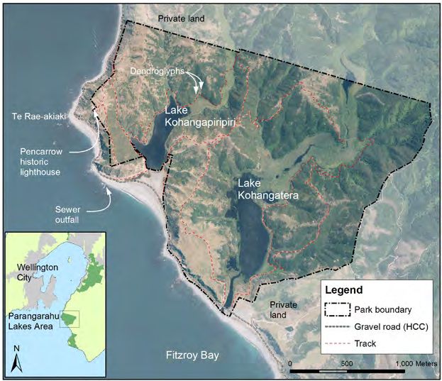
Resource Management Act 1991 provides some
constraints on the type of activities that can occur
as of right and others that require a concession
(in the form of a lease, licence or easement) or
resource consent. Activities are categorised as:
Allowed activities; Taranaki Whānui Kaitiaki
Activities; Managed activities; Restricted activities;
and Prohibited activities.

The final section of the plan sets out the
implementation monitoring and review provisions
and includes an annual work programme,
planning and review cycle that aligns to current
systems used by GWRC. The co-management plan
is intended to have a 10 year lifespan and is both
aspirational and practical in the way it directs
managers to achieve the mutual goals of Taranaki

                                                         DRAFT Parangarahu Lakes Area Co-Management Plan
Whānui and Greater Wellington Regional Council.

                                                                                  3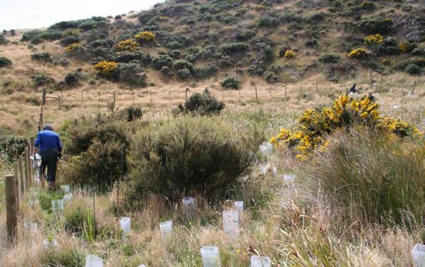
Table of Contents
                                                  Executive Summary                                                                    2

                                                  Section 1: Introduction                                                              6

                                                          Purpose of the Plan                                                          6

                                                          Process for development of plan                                              6

                                                          Relationship to other documents                                              6

                                                          Location                                                                     7

                                                          Titles and legal status                                                      7
DRAFT Parangarahu Lakes Area Co-Management Plan

                                                          Governance roles and management responsibilities                             8

                                                  Section 2: Moemoeā – Vision                                                         11

                                                          Structure of the Management Plan                                            11

                                                          Moemoeā – Vision                                                            11

                                                          Framework of the Roopu Tiaki Moemoeā – Vision                               12

                                                          He Kōrero Whakamarama                                                       13

                                                  Section 3: Mahi Tangata – human activities and land transactions over the years    15

                                                          Early Māori                                                                 15

                                                          Parangarahu Block reserve land title and alienation history                 16

                                                          Parangarahu Lakes Area as part of East Harbour Regional Park                22

                                                          Post Treaty Settlement - a new era of partnership (PNBST & GWRC)            23

                                                          Archaeological sites                                                        23

                                                  Section 4: Te Taiao – Natural Environment                                           27

                                                          Landscape and geology                                                       27

                                                          Ecosystems                                                                  28

                                                          Key Native Ecosystems                                                       28

                                                          Fauna                                                                       28

                                                          Flora                                                                       32

                                                          Cultural heritage resources                                                 33

                                                          Threats35

                                                  Section 5: Management of the land as a Regional Park                                37

                                                  Section 6: Management Objectives and Actions                                        39

                                                  Section 7: Rules for use and development                                            45

                                                          Allowed activities                                                          45

                                                          Taranaki Whānui kaitiaki activities                                         45

4
Managed activities                                                   45

        Restricted activities                                                46

        Prohibited Activities                                                46

        Rules applying to activities in the Parangarahu Lakes Area           47

Section 8: Implementation monitoring and review.                             49

        Works programming and funding                                        49

        Monitoring                                                           49

        Reporting                                                            49

        Review                                                               49

                                                                                   DRAFT Parangarahu Lakes Area Co-Management Plan
Appendix 1: List of lands and legal descriptions                             51

Appendix 2: Recorded archaeological sites                                    53

Appendix 3: Submission Form and Information on submission/workshop process   55

References                                                                   59

        Archaeological Sources                                               61

        Other Reading                                                        62

Amendment to the GWRC Parks Network Plan63

                                                                                                            5
Section 1: Introduction
                                                  Purpose of the Plan

                                                  This plan outlines the co-management approach                          Plan will include a section on the Parangarahu
                                                  by GWRC and PNBST for the Parangarahu Lakes                            Lakes Area, providing the relevant policies
                                                  Area. It is the guiding document for management                        contained within this plan as they apply to the
                                                  of the Parangarahu Lakes Area, setting the vision,                     reserve land for which GWRC has delegated
                                                  guiding principles and the management objectives,                      management responsibility under the Reserves
                                                  policy and actions. The plan is both aspirational                      Act 1977. In management of these areas, GWRC
                                                  and practical in the way it directs managers to                        will be guided by the general provisions of the
                                                  achieve the mutual goals of the two parties.                           Parks Network Plan and the specific objectives and
                                                                                                                         policies of this plan.
                                                  Process for development of plan
                                                                                                                         The vision and guiding principles of both GWRC
                                                  The management plan development work was                               Parks Network Plan and PNBST Strategic Plan2
                                                  undertaken by a project team with support from
DRAFT Parangarahu Lakes Area Co-Management Plan

                                                                                                                         were drawn upon to create the shared Moemoeā-
                                                  GWRC staff and PNBST administrative support. A                         vision of this plan.
                                                  two- phase process was used to develop the plan,
                                                  incorporating face to face workshops and hui to                        Resource Management Act 1991
                                                  facilitate involvement by Taranaki Whānui iwi
                                                  members, and a formal consultation and written                         GWRC also has responsibilities under the
                                                  submission process required by the Reserve Act                         Resource Management Act 1991 to maintain and
                                                  1977.                                                                  protect indigenous biodiversity and to control the
                                                                                                                         effects of resource use on indigenous ecosystems
                                                  Relationship to other documents                                        and habitats of threatened species.3 Guided by
                                                                                                                         the goals of the GWRC Biodiversity Strategy
                                                  There are a number of Acts, planning instruments                       2011-2021, GWRC maintains operational level
                                                  and documents that have been drawn on and                              Key Native Ecosystem Plans (KNEP) and this
                                                  influence the Co-Management Plan. These                                plan provides policy and actions to enable the
                                                  documents will require consideration throughout                        implementation of Parangarahu Lakes Area KNE
                                                  the development and implementation of the                              Plan (2013).
                                                  Moemoeā-vision of this plan. Key legislation plans
                                                  and documents are shown in Figure 1.                                   Long-Term Plans under the LGA

                                                  GWRC Parks Network Plan                                                It is anticipated that a number of actions in this
                                                                                                                         Plan will feed into and influence the GWRC Long-
                                                  The GWRC Parks Network Plan (the management                            Term Plan to ensure GWRC is capable of delivering
                                                  plan for the regional parks and forests) includes                      on priority issues under their jurisdiction and
                                                  East Harbour Regional Park of which Parangarahu                        providing appropriate on-going support. See
                                                  Lakes Area a part.1 The GWRC Parks Network                             Section 8: Implementation, monitoring and review.

                                                  Figure 1. Key Legislation > Strategic Planning / Influential documents > Operational Planning.

                                                                 Resource Management Act 1991 (NPS, NES) Reserves Act 1977, Biosecurity Act 1993, Wildlife Act 1953,
                                                                Conservation Act 1987, Port Nicholson Block (Taranaki Whänui ki Te Upoko o Te Ika) Claims Settlement Act
                                                                                                  2009, Local Government Act 2002.

                                                                                                             PNBST Strategic Plan
                                                                                                          Regional Policy Statement
                                                                           Regional and District Plans, Biodiversity Strategy, Regional Pest Management Strategy,
                                                                                         Wellington Conservation Management Strategy (1996)
                                                                                             Parangarahu Lakes Conservation Covenant 2009
                                                                                                          GWRC Parks Network Plan

                                                                                               Parangarahu Lakes Area Co-Management Plan

                                                                                                       Operational Plans, KNE Plans

6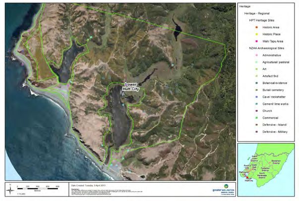
Location

The Parangarahu Lakes Area is located along
Wellington’s Southeast Coast adjacent the main
harbour entrance, nestled behind the distinctive
Te Rae-akiaki (Pencarrow Head) where the
historic Pencarrow Lighthouse is located.
Behind the coastal escarpment lie the nationally
significant freshwater lakes Kohangapiripiri and
Kohangatera.

                                                       DRAFT Parangarahu Lakes Area Co-Management Plan

Map 1: Location and landmarks.

Titles and legal status

The Parangarahu Lakes Area comprises a number
of land parcels of different ownership and legal
status. This plan applies specifically to the titles
owned by or vested in PNBST and GWRC as
shown on Map 2.

Although some adjoining private land forms part
of the Parangarahu Lakes catchment area, this plan
has no statutory weight and places no obligations
on adjoining landowners. The implementation and
success of some of the actions proposed by this
plan relies on adjacent landowner agreement and
participation.

                                                                                7
(A) Owner: Hutt City Council
Private land
Title no.: CFR WN B2/620
Purpose: Sewer outfall
Title no.: CFR WND1/1106
Purpose: Drainage Park
boun
dary
(B) Owner: NZ Historic Places Trust
Purpose: Historic Reserve
(C) Owner: Crown vested in GWRC
(E)
Title no.: CFR 488810 (B) (C) (F)
Purpose: Recreation Reserve
(D) Owner: PNBST
Title no.: CFR 503492
(D)
Subject to Conservation Covenant *
Includes the bed of Lake Kohangipipripiri and
former Esplanade Reserve. Excludes Crown Stratum
Scientific Reserve # (A)
(E) Owner: PNBST
Title no.: CFR 498572
Purpose: Maori Reservation
(F) Owner: GWRC (G)
DRAFT Parangarahu Lakes Area Co-Management Plan
Title no.: CFR WN41A/384
Purpose: Recreation Reserve
(G) Owner: PNBST
Title no.: CFR 503493
Purpose: Subject to Conservation Covenant *
Includes the bed of Lake Kohangatera and former Esplandade Reserve.
Excludes Crown Stratum Scientific Reserve #
(H) Road controlling authority: Hutt City Council
Purpose: Road Reserve (width 20.12m above MHW) Private land
(H)
(I) Owner: Crown. Managed by DOC
Purpose: Government Purpose Reserve (wildlife management)
(I)
0 0.5 1 Kilometres
±
Map 2: The Parangarahu Lakes Area land titles and ownership
* These titles comprise the lake beds and the For a list of the titles with relevant legal
former esplanade reserves and are subject to descriptions that make up the Parangarahu Lakes
Section 27 Conservation Act 1987 and Section 77 Area and adjacent lands refer Appendix 2.
Reserves Act 1977 conservation covenants. The
objectives of the covenant are four fold: Governance roles and management
responsibilities
• for conservation purposes (the natural and
historic qualities/resources of the area) The following section describes the organisations
involved in the governance and management of
• preserving the reserve values (natural the Parangarahu Lakes Area. Some agencies are
environment, landscape amenity, wildlife involved because they are landowners but most
habitat and historic values) have legislative responsibilities.
• providing freedom of access to the public for Te Roopu Tiaki
their appreciation and recreational enjoyment
The Roopu Tiaki was established in 2012 through
• to provide for the enhancement and protection a Memorandum of Understanding agreed between
of Taranaki Whānui’s ancient relationship Port Nicholson Block Settlement Trust (PNBST),
with the land, and ensure that the land is held representing the iwi of Taranaki Whanui, and
and appreciated in accordance with Taranaki Greater Wellington Regional Council (GWRC).
Whānui tikanga. The Roopu Tiaki is an advisory body tasked with
developing a long-term vision for the management
There is also a special condition which means of the Parangarahu Lakes Area and advising on
the owner (PNBST) may authorise members of annual work programmes for the Lakes. It is
Taranaki Whānui to remove medicinal plant comprised of both members from PNBST and
material and traditional food plants and fibres. senior staff members of GWRC. A copy of the
Memorandum of Understanding is available on
# The crown stratum, being that part of the lakes
request from GWRC or PNBST.
comprising the space occupied by water and
air above the lake bed is classified as Scientific Port Nicholson Block Settlement Trust (PNBST)
Reservei. DOC has not sought title to the stratum
however it is still possible to vest the crown PNBST was established in August 2008 to receive
stratum reserves in an administering body and manage the settlement package for Taranaki
pursuant to section 26 of the Reserves Act 1977. Whānui ki Te Upoko o Te Ika (Taranaki Whānui).
i The Crown Stratum is defined in the Port Nicholson Block (Taranaki
Wahnui ki Te Upoko o Te Ika) Claims Settlement Act 2009.
8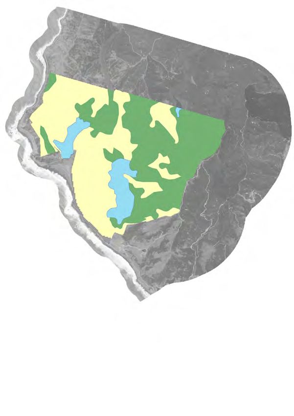
Port Nicholson Block (Taranaki Whānui ki Te                 Until that time, components of this plan that relate
Upoko o Te Ika) Claims Settlement Act 2009 came             to the reserves administered by DOC mustn’t be
into force on 2 September 2009. Part of the package         in conflict with DOCs Conservation Management
included ownership of the lakebeds and former               Strategy for the area. Confirmation of this will be
esplanade reserves of Lake Kohangatera and Lake             sought from DOC.
Kohangapiripiri and two dendroglyph sites. The
Vision of PNBST is:                                         DOC retains a particular interest in preserving
                                                            the high water quality of the lakes, maintaining
Ki te whakahou, whakapakari me te whakanikoniko i te        the wetlands and preserving indigenous flora and
ahurea papori, rangatiratanga o Taranaki Whānui ki te       fauna as far as possible in their natural state. A
                    Ūpoko o te Ika                          Parangarahu Lakes Conservation Covenant for
                                                            each lake signed by DOC and landowner PNBST in
      To restore, revitalise, strengthen and enhance the    2009 sets out the Conservation Values and Reserve
     cultural, social and economic well-being of Taranaki   Values that must be protected. DOC and PNBST
                 Whānui ki te Ūpoko o te Ika.               signed a general relationship protocol as part of
                                                            the Deed of Settlement, which includes among
The Strategic Plan of PNBST sets out four strategic
                                                            other matters sections relevant to Parangarahu

                                                                                                                                   DRAFT Parangarahu Lakes Area Co-Management Plan
goals:
                                                            Lakes, for example, cultural materials, species
1.     To maximise wealth creation and achieve              management, freshwater fisheries and pest control.
       economic and financial well-being.
                                                            As this plan is written, DOC is in the process of
2.     To achieve social and whanau well-being.             reclassifying the existing Government Purpose
                                                            Wildlife Reserve (Map 2 (I)) to Scientific Reserve
3.     To enhance cultural well-being.                      under the Reserves Act 1977
4.     To restore and enhance our natural resources         Hutt City Council (HCC)
       and environmental well-being.4
                                                            HCC hold a number of responsibilities for this
Three members of the Roopu Tiaki are appointed              area, as landowner, infrastructure provider and
by PNBST.                                                   as the territorial authority responsible for the
                                                            implementation of the District Plan for this area.
Greater Wellington Regional Council (GWRC)
                                                            HCC manages the Pencarrow Head sewer outfall,
GWRC is responsible for the management of a
                                                            located immediately west of the Kohangapiripiri
number of Regional Parks and Forests, including
                                                            outlet. This serves the Seaview Wastewater
land at Parangarahu Lakes Area as part of East
                                                            Treatment Plant which collects trade, commercial
Harbour Regional Park. GWRC is also responsible
                                                            and (mainly) residential waste and discharges to
for the Regional Plan which covers this area.
                                                            the ocean. The Pencarrow Coast Road follows the
GWRC Parks, Biodiversity, Biosecurity, and                  coast and is the primary access to Parangarahu
Environmental Monitoring departments all                    Lakes Area, and is owned by HCC for the purpose
provide services to ensure the viability of this            of maintaining the sewer outfall. Permission for
area both as a place of recreation and as one of the        use of the road is granted through HCC on the
region’s most important biodiversity sites. GWRC            basis of the Pencarrow Coast Road Policy for
Parks Network Plan5 and Biodiversity Strategy6 are          Vehicle Use 2012 - 2017.7 Landowners along this
key guiding documents for GWRCs involvement                 section of the coast hold keys and have access for
in the Parangarahu Lakes Area.                              land management purposes, as well as Horokiwi
                                                            Quarries Ltd who extract sand and shingle from
Three GWRC senior staff are members of Roopu                Fitzroy Bay and maintain the road.
Tiaki.
                                                            Part of the escarpment between the Pencarrow
Department of Conservation (DOC)                            Coast Road and the Parangarahu Lakes is owned
                                                            by HCC, as is the outlet of Lake Kohangapiripiri.
The Department of Conservation manages Crown
land and assets. The Crown owns some of the                 Te Atiawa ki te Upoko o Te Ika a Maui Potiki Trust
recreation reserve, the outlet of Lake Kohangatera          (Fisheries Trust)
and the Crown stratum of both lakes (the space
occupied by water and air above the lakebeds).              Te Atiawa ki te Upoko o te Ika a Maui Potiki
The recreation reserve is vested to GWRC                    Trust is a Mandated Iwi Organisation (MIO) for
under the Reserves Act 1977 while DOC retains               managing fisheries of Taranaki Whanui/Te Atiawa
administration of the outlet and Crown stratum,             in Wellington regionii. The Trustees are elected
including the issuing of permits for activities in or       through the three Taranaki Whānui marae in
on the lakes.                                               Wellington and Lower Hutt (Pipitea Marae, Tatau
                                                            o te Po Marae and Waiwhetu Marae). The Fisheries
It is the intention, in the future, that the whole
area, including the parcels held by DOC, will be
                                                            ii The Trust is registered as a charitable entity with the Charities
integrated for management and control purposes.                Commission – Registration number CC38312
                                                               http://www.register.charities.govt.nz

                                                                                                                                                            9
Trust is a registered charity, not only responsible
for the commercial fisheries interests and fisheries
settlement assets of Te Atiawa/Taranaki Whānui,
but also the customary fisheries interests in the
takiwa, including freshwater fisheries. The takiwa
extends from Windy Point in Palliser Bay to
Pipinui Point just north of Makara Beach.8
New Zealand Historic Places Trust (NZHPT)
The NZHPTs work, powers and functions are
prescribed under the Historic Places Trust Act
1993. While protection for land-based historic
heritage is generally administered by local
authorities through their District Plan policies and
heritage listings, the NZHPT retains regulatory
responsibilities regarding archaeological sites. In
DRAFT Parangarahu Lakes Area Co-Management Plan
addition to any resource consents required, an
archaeological authority must be obtained from the
NZHPT where work may involve disturbance of
an archaeological site. There are a number of listed
archaeological sites in the Parangarahu Lakes Area
(refer Map 3, p23).
NZHPT owns and manages the Historic
Pencarrow Lighthouse and the small parcel of land
upon which it sits. Access to this site is through the
recreation reserve.
Others groups with interests in the Parangarahu Lakes
Area
There are a number of other groups with specific
interests in the Lakes including Fish and Game
New Zealand Inc Wellington Region, Royal Forest
and Bird Protection Society Lower Hutt Branch,
Mainlnad Island Restoration Operation (MIRO)
Incorporated, Wellington Wildfowlers Club,
adjacent landowners and Horokiwi Quarries Ltd.
10Section 2: Moemoeä – Vision
Structure of the Management Plan
This management plan is the key document One interpretation of the meaning of the name
for outlining how the Moemoeā-Vision for Kohanga-piripiri is a strongly clinging nest. The
the Parangarahu Lakes Area will be realised. lake is a very windswept place and the hollow
Essentially the plan is structured in the following containing the lagoon was figuratively referred to
way: by the Māori as a ‘nest’ (kohanga), which had to
cling (piripiri), hence ‘a strongly clinging nest’.9
1. Moemoeā - Vision and Oranga Outcomes
Kohanga-te-rā has been interpreted as meaning
2. Guiding Principles a nest basking in the sun in contrast to Kohanga-
3. Mahi Tangata – human history piripiri, the hollow occupied by Kohanga-te-ra is
taken to be a sheltered place, again likened to a
4. Te Taiao – Natural Environment ‘nest’ but one basking in the sun (te rā), and the
DRAFT Parangarahu Lakes Area Co-Management Plan
literal meaning given is ‘nest basking in the sun’.10
5. Management Objectives
The ‘Kohanga Ora’ vision draws together some
6. Management Actions of the following ideas generated during vision
workshops and Roopu Tiaki meetings:
7. Rules for use
• Kohanga is a nest for new life, young growth
Te Reo
and development
Common and Māori names are used
• A nursery sheltering and protecting the young
interchangeably in this plan. The plan provides
(whether plant, animal or human)
definitions for some Māori concepts within the text
or footnotes. • New life, hope and a new generation (people
and environment)
Moemoeä – Vision
• Foundations laid well lead to stronger
The Parangarahu Lakes Area contains the
outcomes and resilience in future
two Lakes; Lake Kohangapiripiri and Lake
Kohangatera and their associated wetlands and • Early learning and education is important
catchment areas. Lake Kohangatera is classified as
a lake of national significance. The combined area • Incubator - for ideas and intellectual
is considered by the Roopu Tiaki to be a taonga development (research & development,
(precious resource) warranting the highest level of business)
conservation and protection, akin to the ‘mainland
island’ concept where the designated island area is • It takes a community to raise a child – it takes
protected by predator proof or boundary fencing. a community to care for our environment
In the lakes context, the concept of a protective
nest (kohanga) is used to recognise the importance
of the Parangarahu Lakes Area and the need to
nurture this taonga through careful management
so that the land, lakes and wetlands can fulfil their
role of nurturing of life and wellbeing.
The Roopu Tiaki Moemoeā – Vision for this plan is:
Kohangapiripiri – Kohangatera - Kohanga Ora –
nests nurturing life and wellbeing
Kohanga Ora may be interpreted as ‘a nest
nurturing life and wellbeing’. The use of the term
‘kohanga’ builds on the names of the two Lakes
and it is aspirational that the combined catchments
of the Lakes and the wetlands and lakes
themselves will be recognised and sought after as
a place for nurturing biodiversity, for regenerating
life, and for sustaining human well-being.
11Framework of the Roopu Tiaki Moemoeä – Vision
Moemoeä - Vision
Kohangapiripiri – Kohangatera - Kohanga Ora
Nests nurturing life and well-being
DRAFT Parangarahu Lakes Area Co-Management Plan
Three Oranga Outcomes Indicators of life, health and well-being
Tuna Heke Manu Korihi Tangata Kaitiaki
Restoration of the eel and Flourishing forested landscape Managers, Visitors and Taranaki
native fishery of the Lakes as a and healthy wetland-lake Whänui are active Kaitiaki
self-replenishing mahinga kai ecosystem sustains multitudes protecting the catchments as
for Taranaki Whänui of birds and indigenous species taonga which contributes to
and a revitalisation of Taranaki personal, community and tribal
Whänui cultural practices wellbeing
Principles for Management of the Parangarahu Lakes Area
1. Kaitiakitanga – Taranaki Whänui exercise kaitiakitanga over their taonga and all people
involved in management or governance activities act to protect the mouri and ensure the
Parangarahu Lakes Area are left in a better state for future generations.
2. Co-Management – Te Roopu Tiaki provides leadership for co-management of the Parangarahu
Lakes Area, reflecting the Treaty Settlement and return of the Lakes to the Taranaki Whänui
as cultural redress. The co-management partnership will foster community cohesion and
participation.
3. Integrated Catchment Management Approach - Management of the Parangarahu Lakes
Area will take into account the catchment areas of both Lakes notwithstanding the legal title and
mixed ownership complexities. Water, wetlands, flora, fauna and people issues are not managed
in isolation but as a living organic system with each part connected to the other parts.
4. Mouri Ora – Management decisions and actions will aim to improve, not degrade, the mouri
of the Parangarahu Lakes Area. This principle means balancing preservation and enhancement
of the Parangarahu Lakes Area for future generations with the provision of appropriate visitor
activities and recreational use.iii
iii Mouri (or Mauri): an energy or life force that tangata whenua consider exists in all things in the natural works, including people. Mouri binds and
animates all things in the physical world. Without mouri, mana cannot flow into a person or object. Spelling of Mouri is Taranaki Dialect.
12He Körero Whakamarama • Clean healthy water and wetlands functioning
as productive nursery and breeding habitats;
This section provides an explanatory narrative of
the various parts of the Moemoeā – Vision • Alignment with GWRC Parks Network Plan
framework. objectives for restoration of ecosystems;
• Matauranga Māori of tuna and tuna fishing is
revitalised and enhanced with new research
2. Manu Korihi - Birdsong
Manu Korihi is the noisy, rousing chorus of
birdsong heard in a healthy forest full of birds.
In this Moemoeā-Vision statement it signals the
return of a flourishing forested landscape that
is capable of nurturing and sustaining life and
large numbers of birds, insects and other native
DRAFT Parangarahu Lakes Area Co-Management Plan
fauna. Restoring the indigenous flora and fauna
of the Lakes area is a priority outcome sought
by Taranaki Whānui and many individuals and
groups who contributed to the development of this
The three eggs within the nest represent oranga co-management plan. Positive indicators for the
outcomes (indicators of life, health and well- achievement of “Manu Korihi” in this Moemoeā-
being). Vision statement include:
The outcomes are: Tuna Heke, Manu Korihi and • A healthy ngahere (forest) has a positive
Tangata Kaitiaki. impact on the wellness of the people;
1. Tuna Heke - Migrating Tuna • Increasing birdsong indicates successful
Tuna heke refers to the seasonal migrations of tuna planting programme and forest regeneration;
(eels) between the Lakes and the sea, both ways. In • Mouri of the ngahere is intact and the forest
this Moemoeā-Vision statement it also represents and valleys are replete with bird and insect
all native fish species and the acknowledgement life.
that these Lakes were once a significant eel fishery
and mahinga kai for Taranaki Whānui and other • Wairua is restored giving people a place for
iwi over the centuries. The loss of eels through healing, re-energising, and respite from the
commercial eeling and overfishing in recent years city;
is a serious concern for Taranaki Whānui and
restoration of this taonga species and valuable food • Non-native animals and plants are managed to
source is a priority objective expressed by many protect indigenous biodiversity;
iwi members during the early consultation phase
• Self-regeneration of indigenous plants / species
of this management plan. Positive indicators for
means less management resource over time
the achievement of “Tuna Heke” in this Moemoeā-
Vision statement include: • Profusion of indigenous plants and animals is
able to sustain future customary harvest e.g.
• A healthy fishery has a positive impact on the
feathers for weaving, wood for carving, kai for
wellness of the people and aligns to the vision
Taranaki Whānui marae, plants for rongoa
statement of PNBST - To restore, revitalise,
strengthen and enhance the cultural, social and • Matauranga Māori relating to the ngahere is
economic well-being of Taranaki Whānui ki te revitalised and enhanced with new research
Upoko o Te Ika;
3. Tangata Kaitiaki - People working together as Kaitiaki
• Abundance of tuna, particularly mature
migrating female tuna ready to leave the Tangata Kaitiaki is the third oranga outcome in
kohanga nursery of the Lakes to return to the the Moemoeā-Vision. As mana whenua, Taranaki
moana (ocean) for spawning and continued Whānui has a kaitiaki relationship and connection
cycle of life; with the Lakes and surrounding whenua. The
Treaty Settlement recognises this relationship. The
• Successful and functioning fish passages at the return of the Lakes to Taranaki Whānui enables
ocean entrances for both Lakes allowing tuna iwi members to better exercise kaitiakitanga
and other native species to migrate to and from responsibilities to protect their cultural heritage.
the Lakes at appropriate times of the year;
The Roopu Tiaki needs strong and enduring
• A self-replenishing fishery that can sustain relationships with others to successfully manage
customary harvest according to tikanga and the Parangarahu Lakes Area and to make
ability for mana whenua to manaaki esteemed significant progress towards achieving the
guests with traditional kai of high value; ‘Kohanga Ora’ Moemoeā-Vision. It will require
13DRAFT Parangarahu Lakes Area Co-Management Plan
combined commitment, shared resources and • Community groups and individuals
sustained action over generations by many tangata are engaged in protecting the natural
kaitiaki. People working together as tangata environment, waahi tapu, archaeological and
kaitiaki include the Roopu Tiaki, elected decision heritage resources which positively impacts on
makers, whanau, hapū, iwi of Taranaki Whānui, well-being;
landowners, local and central government staff,
scientists, heritage experts, recreational users, • Environmental monitoring systems
community groups, and other interested people. incorporate Matauranga Māori methodology
Positive indicators for the achievement of “Tangata and cultural indicators as well as scientific
Kaitiaki” include: assessment tools and technology;
• Taranaki Whānui iwi members exercise • Iwi Kaitiaki regularly monitor the oranga
kaitiakitanga according to their tikanga of the Lake catchments, particularly the eel
and in turn pass their knowledge on to new fishery.
generations of iwi Kaitiaki.
• Dendroglyph (tree carvings) are recorded,
• Roopu Tiaki leads best practice collaborative preserved and protected with appropriate
and innovative co-management between iwi visitor interpretation, including Taranaki
and local government; Whānui Kaitiaki Guides;
• Taranaki Whānui iwi members are • Wānanga and educational activities at the
participating in all areas of governance and Lakes contribute to economic, cultural, social
management; and environmental wellbeing of Taranaki
Whānui and the wider Wellington community.
• Integrated catchment management approach is
standard practice for Parangarahu area; • Appropriate recreational activities and
amenities are provided without degrading
mouri.
Site visit with Taranaki Whanui and GWRC staff.
14Section 3: Mahi Tangata – human activities and land
transactions over the years
As this is the first co-management plan to be now Worser Bay on the Miramar Peninsula but
developed post Treaty settlement, this section which was an island (Motu Kairangi) in their time.
endeavours to give Parangarahu Lakes Area
managers and interested readers some context for Tara’s people (Ngai Tara) occupied areas around
the management objectives and an insight into the west and south of Wellington, including
aspects of Māori history and values associated Wellington harbour. Tautoki’s people occupied
with the area that is perhaps less well known. The the Wairarapa with the boundary being the
section is broadly chronological with an overview Heretaunga (Hutt river) up to the head and on to
of Parangarahu land block history to demonstrate Te Rere-a-Mahanga (near Te Toko-o-Houmeu, on
the Taranaki Whānui history of connection, loss the range west of Featherston).15
and reconnection with this whenua and the lakes.
Tautoki’s fort was the first pā at Parangarahu
The European settler and farming history and era
DRAFT Parangarahu Lakes Area Co-Management Plan
(referred to as Para-ngarehu in historical accounts).
of land management by Government and GWRC
It was situated on the eastern end of what is now
has been previously written about in the East
called Fitzroy Bay, near Orua-Poua-Nui (Baring
Harbour Regional Park Resource Statement, 2007.
Head).
Early Mäori
the fort of Tautoki, that is Para-ngarehu, on the point
Kupe, the legendary Polynesian explorer and of the eastern side (Pencarrow Head) was the site of
discoverer of New Zealand, was possibly one Para-ngarehu, which was also a large fort, though not
of the first visitors to the Parangarahu coastal so large as Te Whetu-kairangi16
area a thousand years ago as he sailed his waka
Inland of the Parangarahu pā was a place of refuge
Matahorua down the east coast of the North
called Takapau-rangi and which is described as
Island in pursuit of te wheke a Muturangi (the
follows:
octopus of Muturangi).11 Traditions tell that
Kupe named many natural landscape features to The refuge hamlet prepared as a dwelling place for
mark significant events, people or places in his women, old men and children, when fleeing from a
journey. There are no accounts of Kupe staying fallen fort, or battlefield, was located at Takapau-rangi,
at Parangarahu but he may have sighted the at the head of Wainui-o-mata, a lagoon to the eastward
entrance to the lakes or sea inlets as he sailed of the Great Harbour of Tara, inland of the fort of Para-
across what is now Fitzroy Bay before entering ngarehu that refuge camp was situated17
Wellington harbour at Te Rae-akiaki (Pencarrow
Head). Traditions say that he stayed for a short In these early years of Māori settlement and inter-
time in Wellington harbour where his name is tribal warfare, Parangarahu pā provided a fortified
still remembered today in key coastal landmarks and strategic position with views over the whole
including Te Tangihanga-o-Kupe (Barrett Reef), of Fitzroy Bay and proximity to both the kaimoana
Te Ure-o-Kupe (Steeple Rock), Matiu and Makaro and sea fishing resources of the bay as well as
(Somes and Ward islands in Wellington harbour).12 access to the rich freshwater fishery of the eel
lagoons, known now as Lake Kohangapiripiri and
Some 600-700 years ago, the first settlers in the Lake Kohangatera.18
Parangarahu and Wellington area were Whatonga
and his son Tara-ika by his first wife Hotuwaipara, Tautoki married Waipuna, a descendant of Kupe,
and his son Tautoki by his second wife, Reretua. and their son Rangitāne was the eponymous
Tara and Tautoki had identified ‘Para-ngarehu’ and ancestor of the Rangitāne iwi. The historical
surrounding area as a potential settlement place connection of Rangitane with the Parangarahu
during their famous exploratory journey from area is acknowledged here. The descendants of
Mahia peninsular down the east coast and back Whatonga and Ngai Tara continued living in the
through the centre of the island. area for many generations and later intermarried
with Ngati Ira who had migrated from Tolaga Bay.
After an examination of that district, they came on to
Rangi-whaka-oma (Castle Point), thence to Okorewa (in Tangata Whenua from 1820
Palliser Bay), thence to Para-ngarehu (Pencarrow Head),
Ngāti Ira (and Ngāti Kahungunu) were
from which place they explored the surrounding district,
acknowledged as tangata whenua in this era
and Tara remarked, “This is a place suitable for us.”13
with pā and kainga on the eastern shores of the
Leaving Mahia peninsular, Whatonga with his Wellington harbour and around the coast to
sons and families first settled on the island of Parangarahu and Orongorongo area. However, by
Mātiu/Somes in the harbour which was named ‘Te the early 1830’s Ngāti Ira had been driven out of
Whanganui-a-Tara’ or the great harbour of Tara.14 the area by Ngāti Mutunga.
Tara and Whatonga then established a fortress
called Whetu Kairangi on the hill above what is
15Ngati-Ira were destroyed at Wai-whetu (Hutt valley), that descend on the western side, for you to drink
Te Mahau, Whio-rau at Okiwi (by Patu-kawenga), the waters thereof; the gullies that descend on the
Kohanga-te-ra (just outside Pencarrow Head), eastern side, I will drink of their waters. Remain here as
Orongorongo (a little to the east of the above, on the neighbours for me hence-forward.”
coast), and at Paraoa-nui.19
The offer of peace was accepted, both sides agreed
Oral history accounts of this era also mention thereto, with many, many speeches. The boundary
Ngāti Kahungunu in connection to the between the two peoples ran from Turaki-rae along the
Parangarahu area: main ridge to Remutaka, along that to Tararua, and on
northward along its summit.21
Te Kume-roa tells me that Ngati-Ira killed a Ngati-
Kahungunu chief at a spot a little to the east of Today at a point on the coast about three
Pencarrow Head, and in the fight a valuable greenstone kilometres north of Castlepoint there is a
mere was lost there. It has often been searched for but commemorative stone cairn and plaque known
never found.20 as ‘Te Wharepouri’s mark’. It indicates the place
of the original stone marker that was erected to
Ngāti Mutunga took over the old pā site and honour the peace agreement between the two
DRAFT Parangarahu Lakes Area Co-Management Plan
cultivations at Parangarahu after defeating Ngāti rangatira.22
Ira but left these in the control of their Te Atiawa
and Taranaki kin when they departed for the The people of Te Atiawa / Taranaki Whānui ki te
Chatham Islands in 1835. Te Atiawa have been in Upoko o te Ika have continued to exercise their
continuous occupation of Te Whanganui –a-Tara tangata whenua rights at Parangarahu through
since that time maintaining ahi kaa (rights of eel fishing, coastal fishing, and seasonal harvest
occupation). of cultural resources despite exclusion by farm
leasing arrangements, alienation of land, public
1839 Peace Agreement between Ngāti Kahungunu and works takings and restrictive Crown policies.
Te Atiawa / Taranaki Whānui ki te Ūpoko o te Ika
Parangarahu Block reserve land title and
Any remaining interests of Ngāti Kahungunu alienation history
at Parangarahu or elsewhere on the Wellington
side of the Rimutaka range were removed, and In the development of this plan it has not been
conflicts between the iwi were settled by the possible to complete a comprehensive block
peace agreement between Te Atiawa rangatira, history to show all the land transactions, leases and
Te Wharepouri and Ngāti Kahungunu rangatira, alienations that occurred from 1840 to the present
Peehi Tu-te-pakihi-rangi. The date of the peace day. That is a potential future research project
agreement was 23 September 1839 just days before that could help to broaden iwi and community
the NZ Company ‘purchase’ of Port Nicholson. understanding about the history of the wider
Parangarahu Lakes area and to learn more about
When the peace making was being discussed by the people who have connections to this whenua,
the two rangatira and their people at the Hutt, to the Lakes and to its resources.
Peehi made the following remarks in his speech
to Honiana Te Puni, to Ngatata, to Kiri-kumara, The following narrative is included to provide
to Miti-kakau, to Taringa-kuri, and the assembled a brief historical overview of some examples of
peoples of Awa and other tribes:— the leasing and alienations that occurred over the
last 165 years to illustrate the loss of management
“List unto me, O ye peoples here assembled. I had control, connection, and access to the Parangarahu
given you no cause to come here and attack me and Lakes Area by Taranaki Whānui. In doing so,
to take my land; by you I was forced to drift away and it attempts to provide some context as to the
dwell upon the lands of strangers. I was induced to importance of the 2009 treaty settlement and the
proceed to the region occupied by the people whose significance of the return of the lakebeds and
weapon is the musket, then I returned here to meet former esplanade reserves of Lake Kohangatera
you folk now before me. Well, yonder is Te Whare-pouri and Lake Kohangapiripiri and two culturally
dwelling at Nuku-taurua, whither he went to induce his significant dendroglyph sites, to Taranaki Whānui
friend Nuku Te Moko-ta-hou to return to these parts. iwi as part of cultural redress.
Now Nuku is dead, and here am I and the chiefs of
Kahungunu assembled before you. Now we are looking Parangarahu Block - Pitone No. 2 Block (McCleverty’s
at this new folk, the pakeha, and his characteristics. Deed 1847)
Who can tell whether he is kind and just to man? For
his weapon is an evil weapon, and his intentions may The Parangarau (Parangarahu) block comprised
also be evil. 4704 acres, 2 roods, 1 perches of unsurveyed land
at Parangarau and the eel lagoons; Whangatera
This is my message to you:—I cannot occupy all the and Whangapiripiri.
land. Yonder stands the great Tararua range, let the
main range be as a shoulder for us. The gulches
16It is noted that the spelling of Parangarahu here
The McCleverty transactions concerned Māori
is without the ‘h’, being Parangarau. This may
cultivations on sections claimed by settlers.
reflect the dropped ‘h’ in Taranaki spoken dialect.
McCleverty assigned land to Wellington Māori
Also noteworthy in the 1847 Deed is the spelling
in ‘exchange’ for their cultivations. These
of the names of the Lakes, being Whangatera and
transactions were investigated by the Waitangi
Whangapiripiri, without the prefix ‘Ko’ which may
Tribunal which found that no genuine exchange
be explained as a particle used before a proper
took place, because the land assigned to Māori by
noun, for example, Ko Pitone te pa, Ko Korokoro te
McCleverty belonged to them already.
awa. ‘Whanga’ could be interpreted as bay, inlet,
or harbour which supports the geological evidence As a consequence, the valuable Mäori cultivations
that the lakes were once arms or inlets of the sea. were obtained at virtually no cost to the Crown or the
company but at considerable cost to Mäori, who lost
much of their best land.25
The land block was formed on the written record
The Parangarahu block was one of the four largest
as part of the Pitone Block Deed signed on 13
outlying McCleverty reserves which included
October 1847 by Lieutenant-Colonel William
DRAFT Parangarahu Lakes Area Co-Management Plan
Orongorongo (6990 acres), Korokoro (1214 acres),
McCleverty and these twenty-one Māori rangatira
Parangarau (Wainuiomata) (4704 acres), and Opau
and people of Pitone pā: 23
(Ohariu) (91431 acres). Notwithstanding the large
Tuari
extent of land in terms of acreage, the Waitangi
Ko te Puni E. Paki Taura
Tribunal noted and recorded McCleverty’s own
Aperahama Hohua te Atua Hone te Meke comments in his final report dated 20 November
Patara te Tapetu 1847:
Paruku Pani Hakopa Rerewa
Wiremu Patene Haimona Hohua Parete …may appear large in extent, but in reality they possess
little land available for cultivation, particularly those at
Waitaratioro Kopu Panapa Pitione Orongorongo and Parangarau26
Henere Te Ware Manihera te Toru Watene
Napaki Mohi Taiata Wirihana Puremu
Figure 2: P
lan of Native Reserve at Parangarau attached to Pitone Block (McCleverty’s Deed), Wellington District,
13 October 184724
17DRAFT Parangarahu Lakes Area Co-Management Plan
Figure 3: ‘Pencarrow Head Fitzroy Bay’, engraving by Samuel Charles Brees published in London in 1849. Looks west from the ridge
between the two lakes. In the foreground, travellers on the coastal track from the Wairarapa heading towards Mt Cameron and the eastern bays. The structure is
not the lighthouse but a round timber tower to act as one of two beacons.33
European settlers and early farming at Parangarahu 38th Settlement. Mukamuka, Pa-rangarahu, and
Orongorongo
As early as 1841, some six years before the
McCleverty Deed of 1847, at least one European Three small fishing villages belonging to Kaiwara,
colonist, William Barnard (Barney) Rhodes, was Pitone, and Pipitea, on the coast between
leasing land at Parangarahu from local Māori for Wairarapa and Wellington, are occasionally visited
grazing cattle.27 In 1842 Rhodes looked to develop by Natives from those Pas, who are included in the
his farming enterprise by erecting a stockyard, census taken of those Settlements, with Report and
placing this advertisement in the local paper, Table for the Wellington District.
the New Zealand Colonist and Port Nicholson
Advertiser: The Blocks or reserves at Parangarahu and
Orongorongo, within a short distance of the
TO FENCERS. Beacon at the heads, are now, and have been for
some time past, let by the Native owners as Cattle
WANTED, a Stockyard erected near Pencarrow Head and Sheep Runs to Europeans at very fair annual
persons willing to contract to put up the above may rents, and as these arrangements are now made
apply at the Stores of W. B. RHODES & CO. Wellington, with a much better understanding than they
August 17, 1842.28 formerly were, (the runs being clearly defined)
there is a mutual benefit: The contractors have
A later survey plan (SO 10240) of the Parangarahu
their fat cattle within a short distance of town,
block shows at least two settlers owning land in
and the Natives derive an annual and almost
the Parangarahu Block. W.B. Rhodes is shown as
certain income from the rents of land which would
the owner of a 30 acre block (section 69, possibly
probably otherwise lie unoccupied.32
Crown grant 852) on the harbour side of the
Pencarrow coast, just north of the Lighthouse Beacon and lighthouse at Pencarrow Head (Te Rae-
reserve. John Cameron is shown as the owner akiaki)
of the upper catchment land of both Lakes.29 Of
whakapapa interest, Rhodes had no children by his The entrance to Wellington harbour was
two Pākehā wives30, but had a daughter (Mary Ann treacherous for shipping and early settlers were
Rhodes-Moorhouse) who was born to a Taranaki vocal in their calls to get coastal lighting erected
Māori woman of Ngāti Ruanui, whose name was at Te Rae-akiaki (Pencarrow Head). Initially in
Otahi or Otahui.31 1842 there was only a beacon in the bay window
of a cottage and then in 1844, a 37 foot beacon was
In 1850, H. Tacy Kemp visited Māori pā around erected [and] painted white with a red flag.34 Key
the Wellington region to carry out a census of dates below show the early establishment history
the Native population. Kemp observed that the of the Pencarrow lighthouse and residence for
owners at Parangarahu and Orongorongo were lighthouse keepers:
leasing land to Europeans and, in his opinion,
earning ‘fair annual rents’ on land that ‘would
probably otherwise lie unoccupied’.
18July 1857 • T
ender accepted for the casting Māori signatories to the Deed of Sale are recorded
of the lighthouse from Messrs as:
Cochrane and Company of
Woodside Iron Works, Dudley, Henare te Puni;
UK. Ngapaki te Puni;
Hana te Puni;
21 June 1858 • T
he lighthouse arrives on board Mawene Hohua; and
the barque Ambrosine in 480 Makareta.
packages.
They signed in their capacity as awardees or
1 January 1859 • N
ew Zealand’s first lighthouse successors of awardees of the McCleverty award
is lit for the first time. of 13 October 1847 of Pitoni lands.36 The sketch
attached to the Deed of Sale document shows
1863 • C
ontrol of the lighthouse the lighthouse block in pink comprising 60 acres
transferred from provincial which reaches right to the sea outlet of Lake
government to Marine Board. Kohangapiripiri and onto the foreshore below the
high tide mark.
DRAFT Parangarahu Lakes Area Co-Management Plan
1865 • T
he lighthouse is sold to the
general government.
1871 • N
ew residences for lighthouse It is significant that the 1867 Judge’s order
keepers erected.35 specified that the Parangarahu block “includes
two salt water lakes for eel fishing”. This is a
It is not known whether the Māori land owners strong indicator that Pitone Mäori, in 1867, were
were consulted, or agreed to, the erection of the maintaining their connection with the Parangarahu
beacon or the more permanent lighthouse. The Lakes area and considered the eel fishery of those
archival records suggested however that the Pitone Lakes to be of such significance that they made
pā owners had for some years made compensation this clear to the Judge, who included the above
demands to the Government for firewood cutting wording in the title order. The description of the
or firewood taking, and for cattle trespass on their lakes as ‘salt water’ lakes is interesting and may
lands at or near the lighthouse. contribute to future cultural and scientific research
on eel populations and salinity levels.
In any case, it wasn’t until 24 September 1873
that the Crown purchased sixty-nine acres of
land situated at Te Raiakiaki or Pencarrow Head
and paid the Māori owners £138 plus £35 rental
payment for occupation from 1 July 1865.
Figure 4: Document signed by Mäori for receipt of payment of £138 sterling for sale of Te Raiakiaki block at Parangarahu37
19Title investigation
Title investigations to the Parangarahu block (5150
acres) commenced in the Native Land Court in
August of 1867. On 5 September 1867, Judge Smith
made an order for the issue of a Certificate of Title
in favour of Henare te Puni and Ngapaki te Puni as
trustees for the members of the Ngati Tawhirikura
branch of the Ngatiawa tribe if, within six months,
Henare te Puni shall furnish a proper survey.38
In its investigation into the adequacy of the 1847
McCleverty reserves, the Waitangi Tribunal noted
that the Parangarau reserve assigned to Pitone
Māori, although situated on a rugged, relatively
barren coastal block distant from their pā on the
Wellington harbour, did contain some cultivations,
plus eel weirs, and fishing stations.39 As such it
DRAFT Parangarahu Lakes Area Co-Management Plan
afforded Pitone Māori with some means with
which to meet their subsistence needs in the short
term, if not their long-term economic needs that
land closer to the new town of Wellington could
have provided.
The Tribunal finds that the Crown neglected to protect Figure 5: Wellington Independent, Volume XXII, Issue 2666, 11 April 1868,
the rights of Mäori living in the Port Nicholson district Page 3
who were parties to the McCleverty deeds by failing
to set aside reserves which left them with an adequate Partition of Parangarahu Block
land base for both their short- and their long-term
cultivation and resource-gathering needs, and which In September 1889 Henare te Puni and others
made adequate provision for Mäori to develop on an made an application to the Native Land Court for
equal footing with Päkehä (particularly by taking up the partition of the Parangarahu block into eight
pastoralism or other farming and land-use activities), parcels. Various people gave evidence about who
and that such Mäori were seriously prejudiced thereby.40 had cultivations at Parangarahu, who had been
to collect karaka berries from Parangarahu, and
Māori sheep farming which individuals belonged to Ngatitawhirikura
hapu, in order to identify entitlement to the eight
Pitone Māori leased some of their reserved land parcels.45
at Parangarahu to Pākehā pastoralists and were
among the few Māori owners in Wellington with On 21 September 1911 the Native Minister applied
sufficient land and opportunity to own and run to cancel the 1889 partition as the Partition Orders
their own sheep farming business. For example, had not been registered under the Land Transfer
Henare Te Puni is one of 15 Natives listed as a Act of 1908. It was not until the following year on
‘flock owner’ in the Wellington Sheep Inspector’s 12 June 1912 that Judge Gilfedder made the final
report dated 28 July 1868.41 His two flocks of sheep partition orders and the Parangarahu block was
numbering 300 sheep at Pitone and 1500 sheep at divided into nine parcels of Native freehold land
Parangarahau42 indicates a substantial enterprise and individual shareholders were named. At the
and that he held a position of some importance same time, the Judge made succession orders for a
in terms of Wellington pastoralism. The Waitangi number of the deceased owners.46
Tribunal noted this was not the ‘norm’ for
Wellington Māori and it didn’t last for long. Public works takings
Significantly, Mäori failed for the most part to take In 1932 the Government decided to build a new
up pastoralism, which required considerable capital, lighthouse at Baring Head situated on part of the
instead renting their reserve land to Pakeha pastoralists Parangarahu 1A block. The Proclamation for this
who could use it more effectively by incorporating it public work taking was advertised in the Evening
into their already large runs. An exception were the Post on 27 January 1939.47
Petone Mäori who were recorded as running sheep on NOTICE IS HEREBY GIVEN that by a Proclamation
the Parangarau block in 1867, but a few years later a dated 23rd December, 1938, and published in the New
Pakeha was leasing the block as a sheep run in their Zealand Gazette, 1938, page 2, the land described in
place.43 the Schedule hereto was taken for the purposes of a
Mawene Hohua, another Māori of Petone pā, was lighthouse in terms of the Public Works Act, 1928.
also in the business of sheep farming with his SCHEDULE: Approximate area of the piece of land
own branded flock until around 1868 when after taken, 42 acres 2 roods, being portion of Subdivisions
his death it seems that his flock of 950 sheep were 1, 2, and 3,Parangarahu No. la Block, situated in Block
‘transferred’ to local Pakeha farmer and pastoralist VIII, Pencarrow Survey District, in the Wellington Land
Daniel Riddiford. 44
20You can also read


