The European Floods Directive and Opportunities offered by Land Use Planning - CSC Report 12
←
→
Page content transcription
If your browser does not render page correctly, please read the page content below
C LIMATE SERVICE CEN TE R

CSC Report 12

The European Floods Directive and
Opportunities offered by Land Use Planning
Cover: © Falk Kienas/ istockphoto.com, doram/ istockphoto.com, ericsphotography/ istockphoto.com

Citation:
Santato, S., Bender, S. & Schaller, M. (2013): The European Floods Directive and Opportunities offered by
Land Use Planning. CSC Report 12, Climate Service Center, Germany
The European Floods Directive and
   Opportunities offered by Land Use Planning
                              Internship-Report by Silvia Santato

                                         March 2013

Host Organization:
Climate Service Center (CSC), Germany

Sending Organization:
University of Venice (IUAV), Italy

Supervisor at CSC:
Dr. Michaela Schaller, Department Head “Management of Natural Resources”

Technical supervisor at CSC:
PD Dr. Steffen Bender, Department “Management of Natural Resources”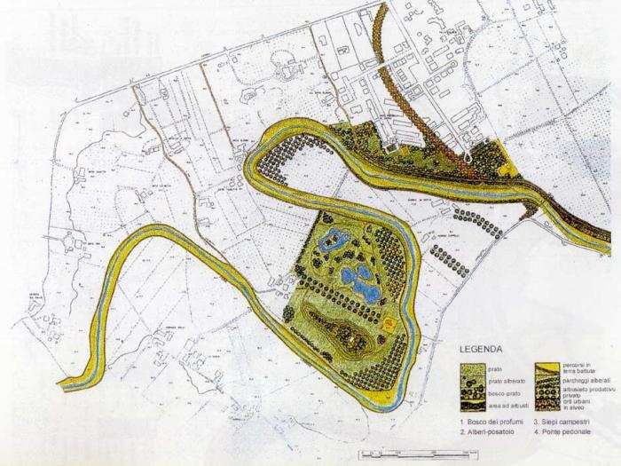
Table of contents

List of figures, boxes and tables                                                         2
Abbreviations                                                                             3
Acknowledgments                                                                           4
Abstract                                                                                  4
Summary of the report                                                                     5

1 Main drivers of flood events                                                            7

    1.1 Extreme precipitation: past trends and projections for Europe                      8
    1.2 Human action increases vulnerability                                              10
    1.3 Urbanization and cities                                                           13

2 The role of land use planning in flood risk management                                  16

   2.1 Preventive land use planning                                                       17
   2.2 Prevention is cheaper than aftercare measures                                      17
   2.3 Multi-scale approaches to manage flooding                                          18
   2.4 Structural and non structural approaches: finding the right balance                20
   2.5 Mitigation under climate change                                                    24
   2.6 Examples of flood prevention from different countries                              26

3 Specific European policies on floods                                                    29

   3.1 The European Floods Directive                                                      29
   3.2 European Floods Directive and European Water Framework Directive                   30
   3.3 The three step approach of the European Floods Directive                           31
   3.4 The importance of stakeholders’ participation in the flood mapping process         34
   3.5 State of the art on the implementation of the European Floods Directive            34
   3.6 Integrating adaptation to Climate Change in European flood policy                  35

4 Flood management and land use planning in selected countries                            37
    4.1 Flood mapping in selected European countries and connection with land
        use planning                                                                      37
    4.2 Overview of the stakeholders’ interviews and introduction to case studies         38
    4.3 Geographical context and law in force dealing with floods in selected countries   42
           4.3.1 Germany                                                                  42
           4.3.2 Italy                                                                    43
           4.3.3 Switzerland                                                              45
    4.4 Case studies                                                                      46
           4.4.1 Introduction to case studies                                             46
           4.4.2 Germany                                                                  46
           4.4.3 Italy                                                                    49
           4.4.4 Switzerland                                                              52
    4.5 Considerations on analyzed case studies                                           53

5 Conclusions and recommendations for land use planners                                   55

6 References                                                                              58

Annex                                                                                     64
  ANNEX 1 - EU funded research projects on Floods and Urban Areas (adaptation)
  ANNEX 2 - Floods Directive: timetable for implementation
  ANNEX 3 - Interviews
  ANNEX 4 - Maps

                                              1
List of figures, boxes and tables
Figures
Fig. 1 Occurrence of flood events in Europe 1998-2010
Fig. 2 Changes in the contribution of heavy rainfall to total precipitation 1961-2006
Fig. 3 Schematic showing the effect on extreme temperatures
Fig. 4 Storm water peak discharges in an urban and less developed watershed
Fig. 5 Water cycle changes associated with urbanization
Fig. 6 Distribution of the floodplain status in Germany
Fig. 7 Hydrologic impacts of urbanization
Fig. 8 Percentage of the city that could be flooded in case rivers rise one metre
Fig. 9 Multi-scale approaches to manage flooding
Fig. 10 Section of Polesine
Fig. 11 Project MOSE in Venice
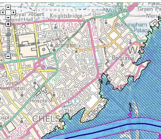
Fig. 12 Environmental Agency’s Flood Map, snapshoot from the city of London
Fig. 13 Web site of the “Flood partnership” in Baden-Württemberg
Fig. 14 Evacuation map for the Netherlands
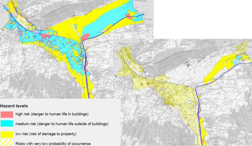
Fig. 15 Hazard zoning and land use planning in Switzerland
Fig. 16 Lower Danube Green Corridor Programme
Fig. 17 Overview of possible spatial measures in the riverine area
Fig. 18 Distribution of land uses on the floodplain to reduce risk
Fig. 19 Conceptual example of an integrated modelling system to help fulfil the EU-FD requirements
Fig. 20 The three implementation steps of the European Floods Directive
Fig. 21 Sustainable city flood (risk) management
Fig. 22 Defence strategy from debris flows
Fig. 23 Screen Shot of the Floods Directive viewer portal
Fig. 24 International partnership between Tirol, Grigioni Canton and Autonomous Province of Bozen
Fig. 25 Scheme for band delimitation: section and plant
Fig. 26 Planning tools in the Autonomous Province of Bozen
Fig. 27 Overview concerning the different types of flood areas in Germany
Fig. 28 The new Emscher Valley
Fig. 29 The river park of Faenza
Fig. 30 Hazard map prior to (left) and after (right) the implementation of the flood protection measures
Boxes
BOX 1 Climate Change and Extreme Events in Europe – Key Points of Floods
BOX 2 Terminology: Mitigation and Adaptation on the flood context
BOX 3 Terminology: prevention, protection, preparedness
Tables
Tab. 1 Overview of the government use of flood maps in selected countries
Tab. 2 Surface of Italy according to the land elevation (ha 000)
2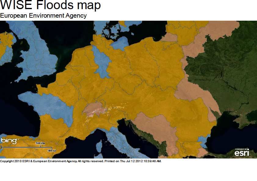
Abbreviations
CC          Climate Change
EEA         European Environmental Agency
EC          European Community
EU          European Union
EU-FD       European Floods Directive
EU-WFD      European Water Framework Directive
FRM         Flood risk management
FRMp        Flood risk management plans
IPCC        Intergovernmental Panel of Climate Change
RB          River Basin
RBMp        River Basin Management Plan

                                             3
Acknowledgments
The report is the result of five months internship at the Climate Service Center in Hamburg
from the 27 of February 2012 to the 26 July 2012 implemented through the LLP_Leonardo
Programme. The report is a natural progression of the master thesis titled “The adaptation to
climate change: the case Polesine”, I.U.A.V. University of Venice, Italy.

Decision makers and those in the chain of accountability in local governance are in contact
with territorial choices, from river basin scale to municipality. For this reason, the report
would be a contribution to spread knowledge and encourage greater hydrological risk
sensitivity in land use planning.

This can be made possible towards prudent choices in planning, updating of practices in
those territories that are always in contact with the river and get them to be visionary,
considering the scenarios of climate change, the present population growth and needs of
future generations.
____________________________

"Modern society has distinct advantages over those civilizations of the past that suffered or
even collapsed for reasons linked to water. We have great knowledge, and the capacity to
disperse that knowledge to the remotest places on earth. We are also beneficiaries of
scientific leaps that have improved weather forecasting, agricultural practices, natural
resources management, disaster prevention, preparedness and management…But only a
rationale and informed political, social and cultural response – and public participation in all
stages of the disaster management cycle – can reduce disaster vulnerability, and ensure that
hazards do not turn into unmanageable disasters"
                                                                                    Kofi Annan
                                                          Message on World Water Day, 2004
_____________________________

Abstract

There is no doubt in the scientific community that man-made change of land use, such as
urbanization or deforestation, increase flooding. Projections show that we can expect more
extreme weather events, such as flash floods, that will become more frequent and intense.
The European Floods Directive is introduced as a reference framework for the prevention of
flood risk. The aim of this report is to raise the awareness towards the potential of spatial
planning for water-related natural hazards and, at the same time, contribute to the
development of a culture of risk prevention rather than relying on post-disaster response and
recovery. For this purpose, five best practices from Germany, Italy and Switzerland are
presented as examples that give more attention and importance to spatial and urban
planning practices and approaches. Land use planning has long been recognised as a
potentially valuable tool in the long-term (non-structural) reduction of human vulnerability to
natural hazards and increase the preparedness of the population.

                                               4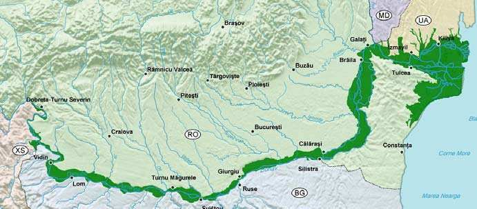
Summary of the report
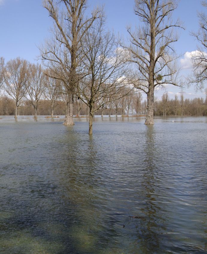
The frequency and intensity of floods in Europe have clearly increased in the last few years
(EEA, 2010a). Between 1950 and 2006, there have been 12 flood events in Europe (flash
floods and river floods) with the number of fatalities exceeding 100 in each case (Barredo,
2006). The severe floods in Europe in the first part of this century were mostly caused by
heavy rain events. The year 2002 proved to be a record year with major flood events in six
EU Member States (Austria, Czech Republic, France Germany, Hungary and Romania). The
total number of deaths was 78 with material damage rising to more than USD 21 billion
(Genovese, 2006; Barredo, 2006 and 2009).
One reason for high flood damages is that people have often settled along rivers because
flood plains provide fertile farmland, resource for economic development and drinking water,
and they act as corridors for transport. Today, “…man has increased the level of valuable
assets in the vicinity of water bodies and has created the potential of damage; if we want to
limit flood damage consistently and quickly, success is better guaranteed by regulating land
use alongside water bodies...”(LAWA, 1995).
Part of the observed upward trend in flood damage can be attributed to 1) socio-economic
factors, such as increases in population, wealth and urbanisation in flood-prone areas, as
well as to 2) land use changes, such as deforestation and loss of wetlands or natural
floodplain storage for example via dike construction, river straightening and floodplain
sedimentation (Feyen at al., 2009). Considering the uncertainty of future conditions shaped
by main drivers such as climate change and rapid urbanization, the situation is getting even
more severe. Where defences exist, the residual risk will increase as the probability
increases that they fail or be overtopped by severe floods. In this unfavourably changing
environment, a substantial rethinking of the existing strategies and a paradigms shift from
traditional approaches is required in order to cope with future flooding in an adequate way.
Experiences show that flood risk reduction must be considered at a range of scales, starting
from the river and water catchment as a whole and linking cities to the river basin system in a
strategic plan, avoiding single sectorial solutions.
Europe is one of the most urbanised continents with around 75 percent of its population living
in urban areas. By 2020, that percentage will increase to 80 or even 90 percent in some
member states (EEA, 2006). The EEA report 2012 (EEA 2012) shows that roughly one fifth
of European cities with over 100.000 inhabitants are very vulnerable to river floods and
extreme rainfall such as “flash floods”. In fact, for decades urban drainage systems have
been optimised to drain a rain shower with a particular return period. Considering future
climate and on-going urbanisation, this 'carrying capacity' has already turned out to be
inadequate in a number of cities (EEA, 2012).
Flood risk management aims to minimise the risks arising from flooding to people, property
and the environment. Minimising risk can be achieved through structural measures that block
or restrict the pathways of floodwaters, such as river or coastal defences, or non-structural
measures that are often aimed at reducing the vulnerability of people and communities, such
as flood warning, hazard-zoning and flood-adapted spatial planning.
While some activities can be designed to mitigate the effects of flooding, many current
practices and structures have unwittingly increased the flood risk. Spatial planning with
respect to agriculture, forestry, the protection of natural areas and the development of
settlements play an important role in the process of flood plain management (Friesecke,
2004), in particular ensuring that future development needs avoid or minimise future
increases in flood risk. The preventative risk reduction by spatial planning process therefore
constitutes a parallel, but inter-dependent process to that of flood risk management.
5
Flood management has shifted from protection against floods to managing floods risk. In
Europe, this shift is reflected in the Floods Directive (EU-FD) of October 2007 (EU, 2007).
The EU-FD shall be carried out in coordination with the European Water Framework
Directive (EU-WFD), notably by flood risk management plans and river basin management
plans being coordinated, and through coordination of the public participation procedures in
the preparation of these plans. All assessments, maps and plans prepared shall be made
available to the public. The EU-FD introduces new instruments to manage risks from
flooding, and is thus highly relevant in the context of adaptation to climate change impacts
(EEA, 2009).

The report describes and compares several instruments and best practices for flood
prevention through risk reduction by spatial and land use planning in Germany, Italy and
Switzerland. For flood prevention there is a strong need to cooperate not only across
different disciplines but also over several levels or scales of planning and decision making.
This includes different administrative levels (state (Bundesland) planning, regional (province)
planning and local and urban development planning) as well as various types of
organisations (governmental, public, municipal, private).

As a result, there is currently great public and stakeholder interest in this issue and it is
necessary to intensify research activities in order to understand natural disasters better and
to reinforce flood risk management.

                                              6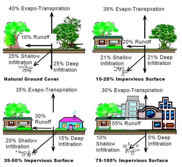
1 Main drivers of flood events
The frequency and intensity of floods in Europe have clearly increased in the last few years,
affecting millions (EEA, 2010a) and causing an increase in economic losses (Barredo, 2009).
Over the past ten years, Europe has experienced more than 165 major floods. An extreme
natural event becomes a disaster when it has a large impact on human settlements and
activities. Flood hazard increases for different reasons and several of them are correlated
(Genovese, 2006) as a result from the confluence of both meteorological and hydrological
factors, exacerbated by human actions (WMO, 2012).

Meteorological factors include rainfall frequency and intensity, storms and temperature.
Hydrological factors include existing soil moisture, groundwater levels, extent of impervious
surface, natural channelization of water courses, and tidal impacts on runoff. Human actors
complicate matters through land use changes, occupation of the flood plain, inadequate
maintenance of drainage infrastructures, and obstruction of drainage channels (WMO, 2012).
According to Kötter (2003), it could be summarized that the two main drivers of flood events
are extreme precipitation and increased vulnerability to natural disasters due to growing
urban population, environmental degradation and a lack of planning, land management and
preparedness. Some climate projections point to more extreme flooding as a consequence of
extreme weather events in the future (IPCC, 2007 and Aerts et al. 2009). Furthermore
human encroachment into unsafe areas has increased the potential for damage and for that
societies become more exposed, developing flood-prone areas (maladaptation).

Background
Flooding is the most widespread natural hazard in Europe in terms of economic loss (CRED,
2009). In the last decade Europe has experienced a number of unusually long lasting rainfall
events that produced severe floods (Fig. 1), e.g. in the Netherlands, Belgium, France and
Germany in 1993 and 1995, the Czech Republic, Poland and Germany in 1997, in northern
Italy (in 1994 and 2000), in the UK (e.g. in 1998, 2000 and 2007), Tisza (in 2000 and 2001),
in the Elbe and Danube in 2002, and in 2005 in Romania and the northern Alpine region
(Austria and Switzerland), in Ireland (2009), France, Italy and Poland (2010), and in
Germany and Italy (2011).

Fig. 1 Occurrence of flood events in Europe 1998-2010. Source: EEA, Based on data from Dartmouth Flood
Observatory.

                                                  7
1.1 Extreme precipitation: past trends and climate change projections for Europe
Past trends
The number of extreme precipitation events has increased over most of the European land
area, linked to warming and increases of atmospheric water vapour. For Europe as a whole,
also the intensity of extreme precipitation such as heavy rain has increased in the past 30
years, even for areas with a decrease in mean precipitation, such as central Europe and the
Mediterranean. In particular, the contribution of heavy rain to total precipitation has increased
(Fig. 2) and is projected to continue to become more frequent.
Fig. 2 Changes in the contribution of heavy rainfall to total precipitation 1961-2006. Source: The climate dataset is
from the EU-FP6 project ENSEMBLES (http://www.ensembles-eu.org) and the data providers in the ECA&D
project (http://eca.knmi.nl).
Changes in Climate Extremes and Climate Variability
Changes in climate variability and extremes of weather and climate events have received
increased attention in the last few years. Understanding changes in climate variability and
climate extremes is made difficult by interactions between the changes in the mean and
variability (Meehl et al., 2000). Such interactions vary from parameter to parameter
depending on their statistical distribution. For example, the distribution of temperatures often
resembles a normal distribution where non-stationarity of the distribution implies changes in
the mean or variance. In such a distribution, an increase in the mean leads to new record
high temperatures (Fig. 3a), but a change in the mean does not imply any change in
variability. For example, in Fig. 3a, the range between the hottest and coldest temperatures
does not change. An increase in variability without a change in the mean implies an increase
in the probability of both hot and cold extremes as well as the absolute value of the extremes
(Fig. 3b). Increases in both the mean and the variability are also possible (Fig. 3c), which
affects (in this example) the probability of hot and cold extremes, with more frequent hot
events including more extreme high temperatures and fewer cold events. Other combinations
of changes in both mean and variability would lead to different results.
Consequently, even when changes in extremes can be documented, unless a specific
analysis has been completed, it is often uncertain whether the changes are caused by a
change in the mean, variance, or both. In addition, uncertainties in the rate of change of the
mean confound interpretation of changes in variance since all variance statistics are
dependent on a reference level, i.e., the mean. For variables that are not well approximated
8by normal distributions, like precipitation, the situation is even more complex, especially for
dry climates. For example, changes in the mean total precipitation can be accompanied by
other changes like the frequency of precipitation or the shape of the distribution including its
variability. All these changes can affect the various aspects of precipitation extremes
inclusive the intensity of precipitation (amount per unit time), (IPCC, 2001).
Fig. 3 Schematic showing the effect on extreme
temperatures when (a) the mean temperature
increases, (b) the variance increases, and (c)
when both the mean and variance increase for a
normal distribution of temperature. Source: IPCC,
2001.
Projections
Projections of statistical aspects of weather and climate extremes can be derived from
climate models representing possible future climate states (Meehl et al., 2000). For the
coming decades, it is projected that global warming will increase the magnitude and
frequency of intense precipitation events in most parts of Europe, especially in the central
and northern parts (Semmler & Jacob, 2004). For Europe as whole it is likely (66 %
probability) that heavy precipitation events will continue to become more frequent (IPCC,
2007). In summer, the frequency of wet days is projected to decrease, but the intensity of
extreme rain showers may increase. In addition, the frequency of several-day precipitation
episodes is projected to increase. Geographically, there is considerable regional
differentiation in the projections. Extreme precipitation events are projected to increase by 17
% in northern and 13 % in central Europe during the 21st century, with no changes projected
in southern Europe (www.climateadaptation.eu).
BOX 1 Climate Change and Extreme Events in Europe – Key Points of Floods
• The main driver of floods and droughts is extreme precipitation linked to regional
soil moisture and atmospheric temperature.
• Changes in extreme climate are likely to have a greater impact on society than
changes in mean climate.
• Flood magnitude and frequency are likely (a 66-90% probability) to increase in
most regions of Europe.
• Expected climate change will intensify the hydrological cycle causing dislocations
and high costs in agriculture and urban areas.
• The European summer climate will affect the incidence of heat waves and droughts
in the future.
• Today's climate models are not (yet) adequate at projecting extreme climate events
in local areas such as flooding in a given river basin, but climate change analysis on
water resources needs to be done at the river basin scale.
• With a rising likelihood of extreme weather conditions and resulting floods and
droughts, the areas prone to these risks should be carefully mapped.
Source: Eisenreich et al., 2005.
91.2 Human action increases vulnerability
Historically, people often settled along rivers because flood plains provide fertile farmland,
resources for economic development and drinking water, and they act as corridors for
transport (Smith & Ward 1998). Due to population growth, the rapid changes in land use in
the last decades from forest to agriculture and settlement, and also river straightening,
detention and other flood protection measures are examples of human impacts that influence
the run-off regime in the river basin system. The latest Corine land-cover inventory for 20061
shows a continued expansion of artificial surfaces, such as urban sprawl and infrastructure
development, at the expense of agricultural land, grasslands and wetlands across Europe.
The loss of wetlands has slowed down somewhat, but Europe had already lost more than
half of its wetlands before 1990 (EEA, 2010a, Cap.6).
The River basin is a system
On a river basin scale the upper catchment part is linked to the lower system via hydrological
processes and the river system. River basins2 are dynamic systems constituted by a complex
arrangement of fluxes between the land and water environment (WMO, 2007). John Wesley
Powell, scientist geographer, put it best when he said that a watershed is: "that area of land,
a bounded hydrologic system, within which all living things are inextricably linked by their
common water course and where, as humans settled, simple logic demanded that they
become part of a community." (http://water.epa.gov/ , United States Environmental Protection
Agency).
The hydrograph (Fig. 4) illustrates storm water peak discharges in an urban watershed (red
line) and a less developed watershed (yellow line). In watersheds with large amounts of
impervious cover, there is a larger volume and faster rate of discharge than in less
developed watersheds, often resulting in more flooding and habitat damage.
Fig. 4 Storm water peak discharges in an urban and less
developed watershed. Source: Santa Clara Valley Urban
Runoff Pollution Prevention Program Hydromodification
Management Plan, 2005. Posted at:
http://ci7e.securesites.net/hmp_final_draft/
The type and density of vegetation cover as well as the changes in land use associated with
urban development (geographically and demographically), help to increase flooding in many
ways: the flood hazard and risk increase partly because there is more exposure, but also
because the process of urbanization itself alters local hydrologic characteristics (Montz,
2000) and disrupts the natural water balance and water storage capacity (WMO 2007). Flood
risk reduction, for urban areas as political or economic units, must be considered at a range
of scales, including the river and groundwater catchment as a whole.
The River basin is shared between undeveloped and urban areas
In undeveloped areas such as forests and grasslands, rainfall and snowmelt are retained on
vegetation, in the soil column, or in surface depressions. When this storage capacity is filled,
runoff flows slowly through soil as subsurface flow (Fig.5). With natural groundcover, 50% of
rain infiltrates into the soil and only 10% ends up as runoff. As imperviousness increases,
less water infiltrates and more and more runs off. In highly urbanized areas, over one-half of
1
Based on EEA Corine land-cover data for 2006. Data coverage is for all 32 EEA member countries — with the exception of
Greece and the United Kingdom — and 6 EEA cooperating countries. Source: Corine land cover 2006 raster data (version
16, 04/2012). www.eea.europa.eu/data-and-maps/data/corine-land-cover-2006-raster.
2
Other terms that are used to describe a drainage basin are catchment, catchment area, catchment basin, drainage area, river
basin and water basin. In the United Kingdom and Australia, a watershed refers to a divide that separates one drainage area
from another drainage area, while in North America, it means the drainage basin or catchment area itself.
10all rain becomes surface runoff, and deep infiltration is only a fraction of what it was naturally
(Chester et al., 1996). Thus, urban areas, where roads and buildings cover much of the land
surface, have less capacity to store rainfall and snowmelt (Konrad, 2003). In the linked
environment of a river basin, upstream actions can influence downstream stakeholders,
therefore, a better understanding and assessment of land use change impacts on the
watershed hydrologic processes, is of great importance for the prediction and mitigation of
flood hazards, and also for the planning, sustainable development and management of the
watershed (Chen et al. 2009).
Fig. 5 Water cycle changes associated with urbanization. Image from:
http://www.swrcb.ca.gov/rwqcb2/water_issues/programs/stormwater/ISDC/Nemo_Fact_Sheet.pdf
Undeveloped areas: forest, flood plain and soil
Forest
Forests play a vital role in the sustainability of clean and reliable water supplies and in the
alleviation of the accelerated sediment release that could clog reservoirs and exacerbate
floods (Haigh et al, 2004). Recent findings have provided correlations between forest loss
and increase in flooding, e.g. the work of Bradshaw et al. (2007), considered 10 years of data
from 56 countries. The study concluded that a decrease in natural forest area of 10%
resulted in an increase of flood frequency from 4% to 28%. In addition, the same 10%
decrease in forests in the surveyed countries resulted in a 4% to 8% increase in total flood
duration.
Forest has the natural ability to absorb water when it rains, and to release that water slowly
into rivers. Thus, deforestation is a cause of increased flooding because the water moves
more quickly from the land to the rivers, causing erosion (raindrop splash) and stripping the
soil. However, the impact of forestry on peak flows depends on the different stages of forest
growth, forest types, climatic zones, soil types, morphology and general land management
practices (EEA, 2001).
11Floodplain
Floodplains are hotspots of biodiversity and central elements of an ecological network. They
are also flood protection areas, greenery of waterways, and areas of agricultural as well as
urban use (Follner et al, 2010). Floodplains, as wetlands and brush lands, are therefore
"flood-prone" and are hazardous to development activities.
In Germany, the Federal Agency for Nature Conservation funded several research projects,
which compiled an inventory of the former floodplain area for the larger rivers, the remaining
active floodplains and their status (Brunotte et al. 2009), to contribute to the implementation
of synergies between nature conservation and flood protection measures. The survey of the
floodplain areas was conducted for sections of the rivers with a catchment area of at least
1,000 km2. Tidal waters were excluded. Remaining active and former floodplains were
assessed. Together they form the geomorphologic floodplain which is defined in this case as
the area which could be inundated, if there were no man-made dikes. For each 1-km section
of the rivers, separately for the left and the right side, the active and former floodplain areas
were assessed and land use, nature conservation value, and protection status were
documented. The data base of the floodplain assessment consists of several digitally
available georeferenced data (GIS) provided by German administrations.
The final report shows that in the past floodplains of larger rivers covered about 15,000 km²,
which corresponds to 4.4% of the German territory, of which two-thirds were lost by
embanking. Less than 10% of the active floodplains fully provide their ecological functions.
The remaining near-natural hardwood forests cover only about 1% of the active floodplain
area (Fig.6). This situation is a result of the intense agricultural use and the former
importance of rivers as routes for transport and trade as well as the arising settlements and
infrastructure. In the former floodplain areas, a small percentage (4%) of “slightly modified”
floodplain sections are left, which apparently still maintained “floodplain-like” without being
inundated (Follner et al., 2010).
Fig. 6 Distribution of the floodplain status
classes for all assessed sections of active
floodplains in Germany.
Source: Follner at al. 2010
Top soil is a non renewable resource
“Il suolo minacciato3” (literally: “The threatened soil”) is an Italian documentary describing
the soil consumption and sealing in the Parma Food Valley. According to Mercalli (1st part of
the documentary) “top soil is a non renewable resource…It is the life support system for
humans and all the form of life”. Top soil, the uppermost layer of soil, has a thickness from 2
inches (5.1 cm) to 8 inches (20 cm). It has the highest concentration of organic matter and
microorganisms and is where most of the Earth's biological soil activity occurs (Millennium
Ecosystem Assessment, 2005). Top soil sealing occurs when agricultural or other rural land
is built on and all soil functions are lost. In Europe, on average, built-up areas take up around
4 % of the total area of Member States, but not all of this is actually sealed. In the decade
1990–2000, the sealed area in the EU-15 increased by 6 %, and the demand for new
construction sites for urban sprawl and for transport infrastructures is continuing to rise (EEA,
2010b).
3
http://www.ilsuolominacciato.it/film.html , by Nicola dall´Olio , only in Italian language.
121.3 Urbanization and cities
Urbanization
Urbanisation reduces the retention area available for natural flood prevention or increases
the number of homes and businesses actually in flood-prone areas (EEA, 2012). The impact
of man-made changes on the hydrology of developing watersheds can be measured in terms
of the ratio: flood peak after development to flood peak before development over a range of
return periods (Kibler et al., 2007). Urbanization increases the frequency of high-flow
discharges and reduces the time to reach peak discharges because of soil sealing and
increased run-off (Saghafian et al., 2008). Heavy rain falls in cities cause surface flooding
because the capacity of the sewage system is temporary not be able to cope with the high
run-off of water. Indeed, much of the flooding in England in the summer of 2007 was due to
surface water (Pitt 2008). The areas with the highest increase in urbanization tended to
match those more prone to floods. However, the analysis of urbanization effects on flood
frequency seems to be a vexing problem, because of a lack of flood data in urban areas and
of nonstationarity/dynamic development processes (Suriya et al. 2011).
The construction of urban transport infrastructure contributes to a constriction of floodplains
and an increase in the area of impermeable (or “sealed”) surfaces. Linear features, such as
roads and railway lines, which do not have sufficient or adequate drainage works, may divert
flows to other areas or increase water levels upstream. Hence, the construction of road and
rail networks can intensify floods and their catastrophic effects (EEA, 2001).
With urban sprawl, a greater number and proportion of watersheds are affected by concrete,
buildings, and other impervious surfaces which impede the rapid infiltration of precipitation
(Roy et al., 2005). These changes to the natural patterns of runoff have resulted in increased
risk to human health and safety, as well as hydrological, geomorphic, and ecological
impairment of receiving stream ecosystems (Allan, 2004). In the following Figure 7,
Andjelkovic (2001) gives a generalized view of the interlocking problems brought on by
urbanization. If the amount or intensity of precipitation is higher than the capacity of the
system, or if parts of the system do not function properly, floods are the result.
Fig. 7 Hydrologic impacts of urbanization. The figure shows a generalized view of water movement in an urban
environment. Source: Andjelkovic, (2001).
13Andjelkovic (2001) also identifies a “minor” system– consisting of sewers, curbs and gutters,
open channels, and swales – and a “major” system– consisting of natural and man-made
pathways for excess water to flow overland to a receiving water body. Floods in urban areas
result from the interactions between these minor and major systems. Many communities did
not know that the system “major” existed until they found water coursing through their
basements, industrial parks, and commercial buildings.
Cities and floods
Differences in urban design and management make cities vulnerable to flooding in different
ways, even those situated in the same geographic region. Excessive amounts of rain water
cannot drain into the ground where a high share of the city's area is imperviously sealed and
thus generate or worsen floods (EEA, 2012). Flooding in urban areas can be caused by flash
floods, coastal floods, or river floods, but there is also a specific flood type that is called
urban flooding. Urban flooding is specific in the fact that it is caused by a lack of drainage in
an urban area. As there is little open soil that can be used for water storage nearly all the
precipitation needs to be transported to surface water or the sewage system. High intensity
rainfall can cause flooding when the city sewage system and draining canals do not have the
capacity to drain the amounts of rainwater. The very same can happen in rural areas and is
then called “ponding” (www.floodsite.net).
Rivers have historically been and continue to be important transport routes. Therefore, most
of Europe's large cities and conurbations are located along major rivers. The EEA (2012)
report shows that roughly one fifth of European cities with over 100.000 inhabitants are very
vulnerable to river flooding (Fig. 8) and “flash floods” from extreme rainfall events.
The map in Fig.8 indicates if a city has a large share of depressions, which can be flooded. It
indicates the risk of considerable damage throughout Europe in particular deltas in the
Netherlands (Rhine-Meuse) and northern Italy (Po). However, the map should be interpreted
with caution, since neither coastal floods nor flood protection measures are considered in the
calculations.
Fig. 8 Percentage of cities that could be flooded in case rivers rise one metre. Source EEA (2012)
Barredo (2006) reports a catalogue of the major flood events since 1950– 2006 in the
European Union and he characterized major floods in terms of casualties and direct
damages. Twenty-three out of the forty-seven events listed in the catalogue are classified as
14flash floods. They are mainly localised in Italy, Spain and southern France. Flash flood
events are also reported in Germany, Belgium and UK.
The high economic losses caused by floods include damage to infrastructure, public and
private property due to the flooding itself, erosion or landslides, indirect losses in or beyond
the flooded areas such as interrupted power generation and deteriorated groundwater quality
caused by pollution or salinization in coastal areas. Socio-economic challenges in the form of
lower productivity, failure of services, loss of jobs and income sources pose additional
problems (EEA, 2012).
A city's weakness does not depend solely on soil sealing but also on rain water
management. For decades urban drainage systems have been optimised to drain a rain
shower with a particular return period. Considering future climate and on-going urbanisation,
this 'carrying capacity' has already turned out to be inadequate in a number of cities (EEA,
2012). One example was the extreme rainfall that took place in Copenhagen in 2011. The
city centre was flooded when over 150 mm of rain fell during a two hour period on 2nd of July
2011. Insurance damages alone were estimated at 650 to 700 million EUR. After the flood
event, there was a governmental decision to change the planning law, for new buildings with
flat roofs. Since then all of these buildings have to be greened.
152 The role of land use planning in flood risk management
Introduction
The way land resources are utilized has a decisive influence on development prospects of
societies. Land Use planning4 is the process undertaken by public authorities to identify,
evaluate and decide on different options for the use of land, including consideration of long
term economic, social and environmental objectives and the implications for different
communities and interest groups, and the subsequent formulation and promulgation of plans
that describe the permitted or acceptable uses (http://preventionweb.net/go/492).
Flood risk management (FRM) aims to reduce the likelihood and/or the impact of floods. By
the end of 2013, all EU Member States have to complete the Flood Risk Management Plans
(FRMp) that should focus first on prevention then on protection and preparedness (EU,
2007). Prevention will be possible through an appropriate land-use practice that prevent
floods damage by avoiding construction of houses and industries in present and future flood-
prone areas and by adapting future developments to the risk of flooding (EC, 2004).
The EU Water Framework Directive (EU-WFD) and the EU Floods Directive (EU-FD) strongly
emphasise the need for closer ties between river basin management and land use planning.
At the same time, European guidance on spatial planning promotes the idea of incorporating
wider social and environmental objectives within planning decisions. Therefore, these two
drivers should promote greater integration between spatial planning systems and the river
basin planning system associated with the EU-WFD (Blackstock et al. 2011) and EU-FD.
Flood prevention in the major European river catchment areas can only be made effective
through the imposition of clear conditions and intervention in land-use (ESDP, 1999). An
integrated and holistic5 approach to flood risk management set within LUp processes is now
seen as an effective way of minimising risk (URS, 2002 and EGLI, 2002). Although this has
not always been recognised in practice and empirical guidance on its implementation, which
is still lacking (e.g. DCLG, 2009 and Carter at al. 2005).
It is increasingly recognised that the management of land and water are inextricably linked
(Defra, 2005) and most human effects on flood risk have rather long time scales: land use
change and urbanisation develop with time scales of decades and centuries and short term
corrections are not possible (Merz et al., 2010). The water management policy and spatial
planning efforts in the long run must concentrate towards attaining an equilibrium stage
between economic development and urbanisation on the one hand and the needs to allocate
more space to water for flow retardation and water retention on the other hand – space that
must be earmarked now. The exigencies of flood prevention must become one of the guiding
principles in spatial planning (EU Water Directors, 2003). Naturally, since these processes
are better understood for a couple of decades, calls have been that planning practices in the
different sectors and groups dealing with land use planning, flood protection or flood risk
management should be interlinked or harmonized and carried out in a coordinated way
throughout a catchment (Greig, 2010).
The human response to the prevailing flood hazard has in most cases been based on the
construction of flood defences, especially levees, storage reservoirs, floodwalls, and
diversions. Contrary, the approach of land use planning should be largely recognized as the
way forward, where development decisions are based on the knowledge of the prevailing
and expected future risks. This is the key to develop planning strategies referring to faced
risk and to gain credence from the society (WMO, 2007).
4
Other Europeans call it Raumordnung, aménagement du territoire, or town and country planning.
5
A holistic approach must take into account all individual factors of influence and all the usages of water within a catchment
area. It is after all a question of reconciling the various competing demands made on a body of water, and this includes the
economic and social needs of people in the region as well as ensuring an ecologically intact environment.
162.1 Preventive land use planning
Amongst the non-structural responses (see paragraph 2.4), land use planning is considered
as one of the more crucial components in managing flood risks (Wheater & Evans, 2009),
especially as a preventive measure. Preventive land use means stopping building
development in flood basins (LAWA, 2010) and discourages any construction or works likely
to form an obstacle to the natural flow of waterways that cannot be justified by the protection
of densely populated areas (EU Water Directors, 2003). Planning measures can reduce the
costs of flood risk by excluding some activities from the floodplain and by providing
conditions under which particular developments would be allowed at locations with given
flood risk. Planning measures are generally not aimed at existing buildings (except for
buildings delocalization) and therefore do not directly reduce the risks of households or
business already located on the floodplain (URS, 2002).
Indirectly planning measures could decrease the total water run-off for example designing
water holding areas in parks and ponds at city level or through an integrated spatial plan with
the main objectives of flood protection, master landscaping and the improvement of overall
environmental conditions of a river at the catchment level (for more examples see Fig.9).
The general driving principle in preventive land use planning is that the development of urban
and industrial areas has to be kept out of main risk zones. It is better to have the land zoned
and used for purposes such as cities and landscapes than to try and ensure that future
development is flooding proofed (Friesecke, 2004).
The European flood action programme emphasises the importance of damage prevention by
appropriate Land Use planning (EC, 2004). Important aspects include:
• avoiding construction of houses and industrial buildings in current and future flood-prone
areas;
• adapting future developments to the risk of flooding;
• appropriate land use, agricultural and forestry practices.
At the regional or river basin level some transnational prevention programmes exist.
Examples include the Rhine across France, Germany, the Netherlands and Switzerland and
the Meuse across Belgium, France and the Netherlands. Wider transnational cooperation is
stimulated by macro-regional strategies of EU regional policy, for example, for the Baltic and
the Danube (EC, 2009b; EC, 2010a; EC, 2010b).
2.2 Prevention is cheaper than aftercare measures
In natural environment, there is no flood damage. The general increase in damage caused
by natural disasters is related to the number of people who live in exposed areas and
accumulate value there (Münchener Rück 2003). The more intensively and the less suitably
the flood basin is used, the greater is the potential for damage and the actual damage when
the flood occurs (E.U., 2003, p. 19).
In Europe, the number of disasters attributed to flooding is on the rise. Since 1998, over 100
major damaging floods have caused 700 fatalities, the displacement of about half a million
people and at least € 25 billion in insured economic losses (EEA, 2003). Examples are the
winter Storms Joachim and Dagmar (12/2011) resulting in insured losses of close to USD
0.7bn in Germany, Scandinavia, France, and Switzerland. Windstorm Friedhelm (12/2011)
battered the UK with hurricane-force winds, destroying vehicles, damaging offshore facilities,
blocking roads, and leading to USD 0.4bn in estimated losses. Hurricane Katia (08/2012)
developed over the Cape Verde Islands and made landfall in Scotland, giving rise to USD
0.2bn in damage. Meanwhile, a slow-moving extra-tropical area of low pressure (named
“Rolf”, 11/2011, the first low pressure system over the Mediterranean to be categorized as a
tropical storm) caused torrential rains and widespread flooding in southern France and
northern Italy, claiming the lives of eleven people and leading to insured losses of USD 0.6bn
(Swiss Re, 2012).
17The extreme consequences of the recent catastrophic events have highlighted that risk
prevention still needs to be improved to reduce human losses and economic damages. For
instance, it is interesting to note that from 2002 to 2008 the European commission Solidarity
Fund has financially supported eight countries to help them recover from flood events, with
about 150 million Euros of funding. Hence, it is essential to investigate and disseminate the
benefits of prevention measures compared to traditional post-disaster recovery.
Prevention means both:
• preventing disasters from happening (when this is possible);
• taking measures to reduce their impacts.
The development of a culture of risk prevention requires the improvement of our:
• Memory and knowledge of past disasters;
• Communication and understanding capacity of current and future hazards;
• Awareness of risk;
• Preparedness for future events.
The EU KULTURisk project (http://www.kulturisk.eu/home) aims at developing a culture of
risk prevention by evaluating the benefits of different risk prevention initiatives. This
evaluation will be carried out by developing a novel methodology and referring to different
types of water-related catastrophes, such as river inundations, urban flash floods, storm
surges, rainfall triggered debris flows and landslides. The Work Package 3 (WP3) is related
to “mapping, planning and risk transfer”. The first Report on WP3 is available at
http://www.kulturisk.eu/results/wp3 and provide a comprehensive and critical review of: i) the
recent development of hydrological and hydraulic models used for mapping flooding and
debris-flow hazards, ii) deterministic and probabilistic methodologies to map water-related
risk, iii) land-use and urbanisation planning as well as risk transfer (insurance policy)
practices in water-threatened areas.
In order to demonstrate the advantages of prevention options, an original methodology will
be developed, applied and validated using specific European case studies, including
transboundary areas. The benefits of state-of-the-art prevention measures, such as early
warning systems, non-structural options (e.g. mapping and planning), risk transfer strategies
(e.g. insurance policy), and structural initiatives, will be demonstrated in the project.
KULTURisk is initially focused on water-related hazards as the likelihood and adverse
impacts of water-related catastrophes might increase in the near future due to of land-use
and/or climate changes. In particular, a variety of case studies characterised by diverse
socio-economic contexts, different types of water-related hazards (floods, debris flows and
landslides, storm surges) and space-time scales will be utilised. Finally, the applicability of
the KULTURisk approach to different types of natural hazards (e.g. earthquakes, forest fires)
will also be analysed.
2.3 Multi-scale approaches to manage flooding
In each country, community and city, there are different situations and different answers to
problems with respect to flooding and living in cities prone to flooding. Flood risk reduction
must be considered at a range of scales, including the whole water system (Fig.10). Also,
experience has shown that local flood protection measures can have negative effects both
downstream and upstream. According to Shaw et al. (2007) and Jha et al. (2012), there are
different approaches to manage the risk of flooding focusing on three (or four) spatial scales:
the conurbation/catchment scale, (the city scale) the neighbourhood and the building scale.
The following diagram (Fig.9) illustrates the actions and possible techniques which have to
be considered to create an integrated flood risk solution. It summarized the range of actions
and techniques available using practical examples to managing the risk of flooding and it is
18promoted by the United Kingdom's Town and Country Planning Association (TCPA) in the
third “Design Guide for Sustainable Communities”, Shaw et al. (2007).
At the catchment scale the main goals should be to integration of green and the
establishment of retention rooms (e.g. sports fields and car parks) to increase the temporary
water storage capacity during flood events, which helps to reduce peak flows.
At the neighbourhood scale, efforts should focus on understanding and managing flood
pathways and protecting areas at risk. Well designed adaptation can have additional benefits
for water quality and resource management, and enhance public spaces. Similar solutions
from catchment flood risk management strategies can be applied at the neighbourhood level
and include, for example, the replacement of impermeable surfaces by Sustainable Drainage
Systems (SUDS), such as permeable pavement, gravel or grass so that water can soak
away.
The aim at building scale should be to minimise the exposure to flooding whilst incorporating
structural solutions, which help to reduce the vulnerability. New developments need to be
carefully assessed to ensure that they are built to cope with flood risks as they change over
time and that risks in adjacent areas are not exacerbated. Existing buildings can take
advantage of new materials and products to minimize flood risks. Though it must be stressed
that these strategies do not always make new development in the floodplain acceptable in
flood risk terms – they are aimed to protect existing development.
Fig. 9 Multi-scale approaches to manage flooding. Source: Shaw et al., 2007.
192.4 Structural and non structural approaches: finding the right balance
Traditionally, flood risk reduction has been concentrated on the construction of embankments
and retention by reservoirs. Such measures, also called flood control strategies, aim at
reducing the flood hazard, i.e. the probability of hazardous flooding. Attempts to decrease
vulnerability, i.e. the other aspect of risk, have been of minor importance (Merz et al., 2010).
Meanwhile, it is well recognized that structural flood control alone does not solve the flood
problem and countries are moving towards more integrative practices (Alphen & Bourget,
2010) that recognize the importance of a coherent set of flood risk management measures.
Flooding is controlled by a combination of structural and non-structural measures enabling
the riverside population to minimize its losses and continue to live in harmony with the river.
These include engineering, social, economic and administrative measures. Planning of
protection against flooding and its effects involves research into the ideal combination of
these measures (Tucci, 2007, Mambretti et al., 2008). The paradigm shift from “providing the
safe level of protection” to “reducing the risk to the acceptable level” is possible only through
wide acceptance of the fact that absolute safety is impossible to achieve and that every
individual, community and state must adapt to a certain level of flood risk (Anzeljc, 2010).
There is no single response that will reduce flood risk substantially and that is completely
sustainable. Different response measures will vary under different scenarios, and the
Government needs to support the concept of a portfolio of responses to decreasing flood
risk, which should include structural and non-structural solutions (Evans et al. 2008).
Measures which can be implemented more quickly (such as operations and maintenance,
greening of urban areas, improved drainage, building design and retrofitted protection
measures) can also enable occupation of flood risk areas while minimizing the expected
damage from flooding (Jha et al., 2012).
Structural flood management measures often are not an adequate answer. The
disadvantage of this strategy is its finiteness of effectiveness. Recently, levee systems have
been built along Mississippi and Sacramento Rivers in the United States and Rhine, Loire,
Vistula, Scheldt and Danube Rivers in Europe. Examples for the non-effectiveness of
existing structural measures are the recent flood events (Serbia, Romania and Bulgaria
2006, New Orleans 2005, Bangladesh 2004). In light of this there is a growing realisation that
various flood mitigation measures exist – and not only structural measures such as dams
and dikes – and must be combined in an integrated approach to flood management
(Friesecke, 2004).
Structural measures
Structural flood management measures are any physical construction to reduce or avoid
possible impacts of hazards, or application of engineering techniques to achieve hazard-
resistance and resilience in structures or systems (http://www.preventionweb.net). Avoiding
the impacts of flooding will continue to imply the use of protection structures such as dikes
and embankments, a fact also recognised in current flood management plans such as the
Bavarian Plan for Flood Protection (Bayerisches Staatsministerium für Umwelt, Gesundheit
und Verbraucherschutz, Bayern 2005).
The 100-year flood event on the lower Danube in 2006 caused suffering and even loss of life:
10 people were killed and ca. 30.000 people displaced; damage was estimated at more than
half a billion Euro. In Romania alone, agricultural polders, which provide livelihoods for local
people, were heavily impacted during the floods: an area of 70.000 ha was flooded affecting
10.000 people. In Serbia about 240,000 ha of agricultural land was flooded, approximately
one half by rivers and the other half by groundwater. 2000 houses in 30 communities within
unprotected areas were flooded. Civil Defence evacuated about 1000 residents. Water
management companies reported flood defence costs of approximately €10 million. Damage
was initially estimated at roughly €40 million. The Danube floodwater also resulted in bank
overflow on the Bulgarian side and seriously affected an area of several hundred kilometres
along the Danube River: It was necessary to evacuate over 2000 people (ICPDR, 2008).
20In 29 August 2005 there were over 50 failures of the levees and flood walls protecting New
Orleans, Louisiana, and its suburbs following passage of Hurricane Katrina and landfall in
Mississippi. The levee and flood wall failures caused flooding in 80% of New Orleans and all
of St. Bernard Parish. Tens of billions of gallons of water spilled into vast areas of New
Orleans, flooding over 100,000 homes and businesses (ASCE, 2007).
The Afsluitdijk (lit. Closure-dike) is a major dike in the Netherlands with a length of 32 km and
a width of 90 m, at an initial height of 7.25 m above sea-level. The Netherlands has become
prosperous due to its favourable position in the delta of several large rivers. But without
strong flood defences two-thirds of the country would be under water. Nine million people live
in this vulnerable area of the Netherlands where 65% of the gross national product is earned.
Monitoring the condition of the flood defences is therefore absolutely vital. The condition of
the “primary flood defences” is particularly crucial. They protect the land from water from the
sea, the major rivers and from the IJsselmeer and the Markermeer lakes.
Fig. 10 Section of Polesine. graphic of Maurizio Conci.
Polesine is a wide plain located between the lower portion of the rivers Adige and Po (Fig.
10), with many areas below sea level; thus the mechanical drainage of land allows the
maintenance of this area.
The only structures that rise are the manmade channel’s embankments (Santato, 2011).
The project MOSE in Venice (Fig.11) is a system of tidal regulation works that can cope with
a difference in level between sea and lagoon of as much as two metres. MOSE has been
designed on the basis of a precautionary criterion to cope with an increase of up to 60 cm in
sea level, in other words, higher even than the latest estimates from the 4th IPCC report
which projects an increase in sea level of between 18 cm and 59 cm during the next 100
years. So even in the worst possible scenario of that time, Venice and other built up areas in
the lagoon would be protected.
Fig. 11 Project MOSE in Venice. Source: http://www.salve.it
21You can also read