Mumbai Case Study - Ramboll
←
→
Page content transcription
If your browser does not render page correctly, please read the page content below
Report MIT Mumbai, Wescoat

Mumbai Case Study

Product of research on “Enhancing Blue-Green Environmental and Social
Performance in High Density Urban Environments”
Sponsored by the Ramboll Foundation

13 July 2015

Authors:
Smita Rawoot, James L. Wescoat Jr., Karen Noiva, and Alex Marks
Massachusetts Institute of Technology

                                                                                     Page 1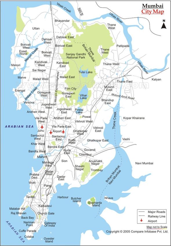
Report MIT Mumbai, Wescoat

CONTENT

1.
   PREFACE
  ...........................................................................................................................................
  3

2.
   DEFINITION OF BLUE-GREEN INFRASTRUCTURE (BGI) IN THE MUMBAI
CONTEXT
  ....................................................................................................................................................
  4

3.
   SITUATING MUMBAI’S BLUE-GREEN INFRASTRUCTURE IN A LOCAL,
REGIONAL, AND COMPARATIVE INTERNATIONAL CONTEXT
  ...............................
  9

4.
   CHALLENGES MUMBAI IS FACING TODAY
  ...............................................................
  16

5.
   HISTORICAL GEOGRAPHY OF MUMBAI
  .....................................................................
  20


6.
   TYPOLOGIES OF BLUE-GREEN INFRASTRUCTURE IN MUMBAI
  ..............
  25

7.
   INSTITUTIONS AND GOVERNANCE
  ...............................................................................
  29

8.
   MAJOR BGI CASE STUDIES IN MUMBAI
  .....................................................................
  33

9.
   FINDINGS AND RECOMMENDATIONS FOR IMPLEMENTING BGI IN
MUMBAI
  ......................................................................................................................................................
  66

10.
   REFERENCES
  ..............................................................................................................................
  1


                                                                                                                                                             Page 2
Report MIT Mumbai, Wescoat

1. PREFACE

This report summarizes the research, findings, and recommendations of the Blue-Green
Infrastructure (BGI) case study in Mumbai, India. It is one of seven case studies in the
comparative research project funded by the Ramboll Foundation. Blue-green infrastructure
extends the well-established concept of green infrastructure (e.g., open space and tree canopy)
to encompass hydrologic systems and processes that make enormous contributions to the
aesthetic, functional, and cultural values of urban landscapes.

Mumbai was selected as a case study for several reasons. First, it has a suite of blue-green
infrastructure systems that include watershed headwaters that are protected as a National Park,
stream corridors that radiate from those headwaters through the city, and a variety of urban
coastal areas some of which have mangrove tidal flats. Second, these systems face enormous
pressures and are not yet integrated in a metropolitan BGI system. Third, this is one of only two
case studies in the Ramboll project, which involves a megacity in a rapidly developing country.
And finally, notwithstanding these distinctive aspects of Mumbai, it also offers valuable
comparisons, for example, with Singapore, Boston, Copenhagen, and Jakarta, all of which have
long histories of urban environmental planning and coastal land reclamation. Mumbai is thus a
model and problematic case study where much is at stake in BGI protection and integration.

Figure 1. Map of Mumbai water and land resources.

Outline of the Report

This preface is followed by a brief section common to all of the Ramboll case studies that defines
blue-green infrastructure along with some brief notes about its relevance for Mumbai. The third
section of the report then helps situate and address those challenges with at three levels of
analysis -- the local, regional, and comparative international. The Mumbai study differs from

                                                                                                Page 3
Report MIT Mumbai, Wescoat

others in the Ramboll project in part by having three BGI components -- the Sanjay Gandhi
National Park, Mithi River, and Coastal zone, which are at present not integrated or jointly
managed with one another. After briefly noting these three main environmental systems, we
describe Mumbai’s overall urban density, water supply, and water demand; and we compare
these characteristics of Mumbai with a large database of other cities. The fourth section
summarizes some of the major planning challenges faced by Mumbai today. The fifth section
outlines the historical geography of the city of Mumbai, the evolution of its current geographic
landscape, and its unique water heritage. The sixth section discusses different types of blue-
green infrastructure and a typology for BGI research and study. The seventh section of the
report describes the institutional and governance structures that currently govern the blue green
infrastructures of the city of Mumbai and the larger metropolitan area of Mumbai.

With this conceptual framework in place, the eighth and longest section of the report presents the
three major BGI case studies in Mumbai -- the Sanjay Gandhi National Park in the headwaters;
the urban streams that flow through the city (particularly the Mithi River); and the coastal zone.
Each of these cases includes a chronology and a discussion of driving forces, constraints, and
values. The attempt will be to present a BGI case from each typology to understand and propose
a networked system of BGI that can truly function as a productive natural infrastructure for the city
of Mumbai and the greater metropolitan region. The study concludes with recommendations and
proposals that highlight the next steps required for the development of an integrated BGI
landscape system in Mumbai.

2. DEFINITION OF BLUE-GREEN INFRASTRUCTURE (BGI) IN THE MUMBAI
   CONTEXT

This section introduces the concept of blue-green infrastructure (BGI), with some initial comments
on its relevance for Mumbai. This definition of BGI is shared across all of the Ramboll case
studies. A more Mumbai-specific case study of BGI is presented later in the report.

The concept of „green infrastructure“ and its benefits for ecology and social life are increasingly
well established in urban environmental planning, policy, research, and design. However, much
green infrastructure is closely linked with and even defined by „blue“ water processes. Some
cities such as Mumbai continue to describe these values and systems as „parks“ and „open
space.“ Unfortunately, other water bodies and sites are treated as waste spaces for pollutant
discharge. Open space in this context may seem somewhat negative in meaning.

At the same time, an increasing number of cities are creating or restoring urban water bodies and
systems to enhance urban livability and quality of life. Blue-green infrastructure projects are
proliferating in exciting ways. Research is now needed to identify, analyze, and enhance the

                                                                                               Page 4
Report MIT Mumbai, Wescoat

benefits and added values stemming from this combination of blue-green infrastructure,
especially its impact on improving social life and human-environmental experience.

Mumbai has a fascinating history of BGI development associated initially with land reclamation,
and subsequently with early attempts at environmental protection.

What do we mean by Blue-Green Infrastructure (BGI)?

Blue-green infrastructure (BGI) is a dynamic system in urban contexts that connect vegetation
with water bodies. BGI integrates hydrological and biological water treatment systems where
green features are integrated and seamlessly overlapping with blue features. Together they
strengthen urban ecosystems by evoking natural processes in man-made environments. The
hypothesis is that such systems have a positive impact on the experience and behavior of people
using these infrastructures that have societal benefits.

The term green infrastructure often refers to areas with plants including their rhizomes and
natural substrates like parks, green roofs, greenbelts, allees, vertical gardens on buildings, etc.
The reclamation of the Back Bay, Mumbai Esplanade, Maidan, and Queens Necklace were early
examples of this concept, arising with the modern origin of the city itself to provide common
space in the 19th century. Interestingly, these are some of the same place-names used in
Boston (e.g., Back Bay and Esplanade). “But BGI often involves non-vegetative, constructed
surfaces and substrates, such as porous hardscape, loose stone infiltration basins, gravel
wetlands and specialized soils for root growth in narrow spaces.”

Blue infrastructure is related to hydrological functions including urban storm water systems as
well as surface and groundwater bodies. This water infrastructure may be natural, adapted or
man-made and provide the functions of retention, storm water treatment, reuse, groundwater
infiltration, sewer treatment, freshwater supply, etc. Coastal cities like Mumbai originate around
the blue infrastructure of freshwater supplies adjacent to tidal rivers and harbors for trade.

Blue-green infrastructure brings these two systems and values together in ways that are greater
than the sum of their individual benefits. The benefits of this more integrated approach can range
from a stronger sense of place to the health, happiness, and aesthetics of urban environmental
experience. Mumbai’s early blue-green infrastructure concentrated around the reclamation of
coastal wetlands and shorelines.

In BGI research we especially look at cases where these benefits can be documented, and where
blue-green infrastructure can be actively used by people, thus being relevant for social life in
areas for recreation, improvement of walkability or bikeability, and beauty.

                                                                                                 Page 5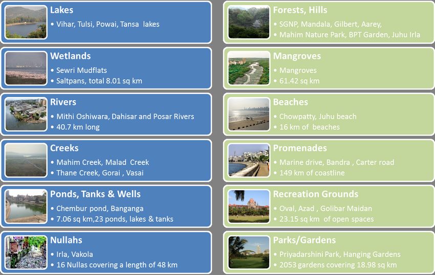
Report MIT Mumbai, Wescoat

What are the objectives of BGI?

   •   Blue-green infrastructure combines the demands of sustainable water and stormwater
       management with the demands of urban planning and urban life, and thus it:
   •   Brings the urban water cycle closer to natural hydrologic processes to provide more
       efficient water treatment, use, supply, as well as mitigation of droughts and floods)
   •   Contributes to the visual and recreational amenity of the city’s ecological and built
       environment.
   •   Helps manage conflicts between urban settlements and negative impact on natural
       systems in innovative ways (e.g., by protecting ecosystems, caring for public open
       spaces, and adapting to for climate change,)
   •   Improves urban sustainability and livability.

                                                                                               Page 6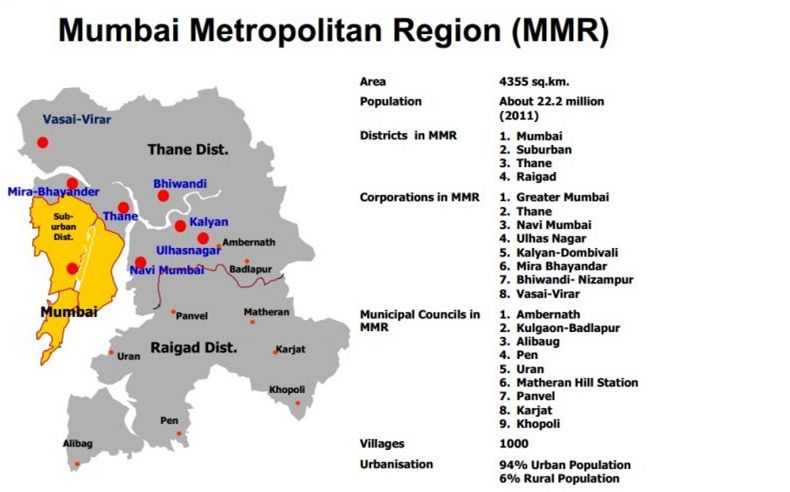
Report MIT Mumbai, Wescoat

                                                        This graphic illustrates the gradient from
                                                        grey infrastructure at the top to blue and
                                                        green infrastructure being adjacent but
                                                        functionally separated from each other
                                                        (second) to overlapping blue and green
                                                        infrastructure in a riverbed with green banks
                                                        (third) to full integration of blue-green
                                                        stormwater management from on roof tops
                                                        and vertical gardens to naturalistic drainage
                                                        systems (bottom).

                                                        The most defining quality of BGI is this
                                                        overlapping of blue and green features and
                                                        processes that provide relevant functions
                                                        and services. Its services are (1) water
                                                        related, (2) ecosystems related, (3) have
                                                        benefits on the social life and by doing so
                                                        are (4) financially relevant.

Blue-green infrastructure: gradient from separated to
integrated systems (Herbert Dreiseitl)

                                                                                                     Page 7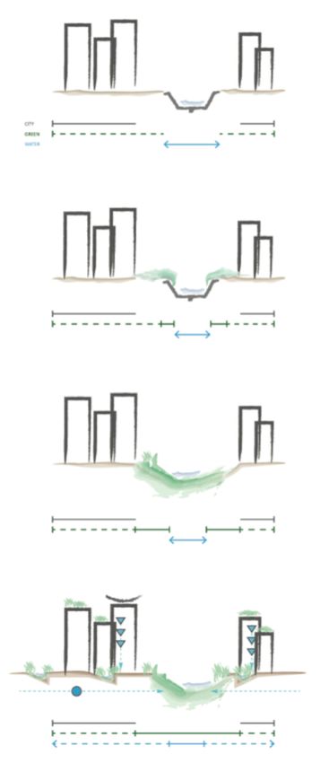
Report MIT Mumbai, Wescoat

This intersection of blue, green and social benefits can:

    •   Balance water flows (Reduce stormwater runoff and peak flows through local detention
        and retention measures in soil interstices, minimization impervious areas, etc.)
    •   Improve water quality (reduce organic pollution through mechanical filtration, biological
        cleaning, accumulation of oxygen in the soil, etc.)
    •   Enhance ecosystem services (micro climate improvement like balanced temperatures
        and evaporative cooling, buffer wet and dry conditions, increase of biodiversity, reduce
        fine dust and improve air quality, metabolism and photosynthesis, etc.)
    •   Broaden societal benefits (recreational spots for mental and physical health, attractive
        meeting places, promotion of creativity, aesthetical values, etc.)
    •   Increase financial benefits (reduce drainage infrastructure and the related development
        and maintenance costs, etc.)

What is needed to create Blue-Green Infrastructure?

To implement BGI projects or citywide systems, an interdisciplinary cooperation of water
management and urban environmental planning and design is needed. BGI considers all parts of
the hydrological cycle and strives for its integration with the design of green spaces. Integrative
strategies care jointly about ecological, economic, social, and cultural sustainability. The Mumbai
case study shows that institutional coordination is ideal, and that integrative approaches to BGI
design and implementation can occur within single or multi-agency contexts.

As demonstrated by the principles for Water Sensitive Urban Planning, methods and technologies
that were once solely a civil engineering issue, are expanding to include a much broader array of
disciplines. This adds a level of complexity never-before seen in stormwater management
discourse, for example, particularly with regard to aesthetics and open space planning. The main
challenges for sustainable stormwater management are not technological, but increasing
awareness of the benefits and supportive skills needed for BGI implementation. To move forward,
communication must improve, and ecologic, economic and social arguments proven by data-
driven analysis.

                                                                                               Page 8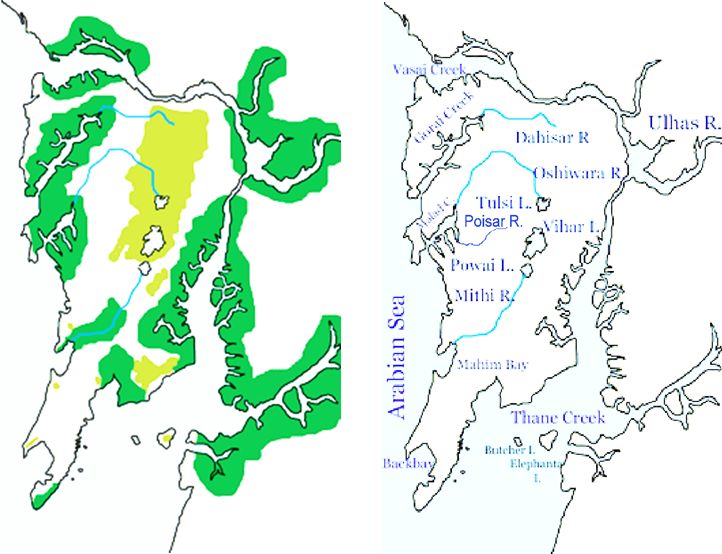
Report MIT Mumbai, Wescoat

3. SITUATING MUMBAI’S BLUE-GREEN INFRASTRUCTURE IN A LOCAL,
   REGIONAL, AND COMPARATIVE INTERNATIONAL CONTEXT

This section introduces the Mumbai case study in greater detail. It describes the case at three
geographical scales. First, it briefly describes the three types of Mumbai’s Blue-Green
Infrastructure analyzed in this report. We then proceed to a broader regional perspective on
regional water and environmental systems. Finally, we scale out to consider how Mumbai’s
urban water system compares with that of other cities around the world including the seven other
Ramboll case study cities. This sets the stage for an analysis of the planning challenges that
cities like Mumbai face in section 4.

a. Mumbai as a set of places, landscape types, and institutions
Although Mumbai does not have one particular focal blue-green infrastructure project in this
study, the City has a rich variety of places that function implicitly, explicitly, or potentially as such.
As will be shown, the Sanjay Gandhi National Park is a consciously protected blue and green
infrastructure project. The coastal zone is an implicit form of BGI. And the many streams and
nallahs are rapidly degraded but could still potentially function as such. As these water and
environmental systems are described in detail in the sections that follow, here we proceed to set
the Mumbai urban water system in context.

b. Profile of Mumbai and its Water Resources
In this section we introduce the broader context of Mumbai as a city defined in part by its
population size and density, in part by its hydroclimatic water supply, and in part by its per capita
water demand.

i. Population Size and Density
Mumbai, India is the capital city of the state of Maharashtra. With a municipal population of
12,655,220 and a metropolitan population of 20,748,395 in 2011, it is the world's eighth largest
city and eleventh largest metropolitan area. Mumbai is the second largest metropolitan area in
India (after Delhi). It has been an urban center and important trade node in the region for
                                                                         2
hundreds if not thousands of years. Mumbai's city area is 603.4 km and its population density is
                   2
20,973 people/km . It's population density is higher than that of Tokyo and other cities that are
generally considered quite dense, including Jakarta and Seoul.

As a city of India, Mumbai has a medium Human Development Index (HDI) of 0.586. Its HDI has
increased in recent years. The Brookings Institute estimate for Mumbai's 2014 GDP was $150.9
billion[1]. Dividing by the population of Mumbai city and metropolitan area gives a GDP per capita

                                                                                                   Page 9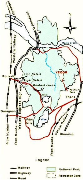
Report MIT Mumbai, Wescoat

of $11,924 and $7,273, respectively (as reported in Wikipedia. URL:
//en.wikipedia.org/wiki/List_of_cities_by_GDP#cite_note-Brookings-2, Last Accessed: 11 July
2015).

ii. Hydroclimatologic Water Supply
This section describes the natural water supply locally available to Mumbai. The city’s gross
water supply comes in the form of monsoon rainfall, and it is partially consumed by
evapotranspiration, particularly in the hot dry pre-monsoon months. Mumbai is located at a
latitude of 18°58'N and a longitude of 72°50'E on the west coast of India, which receives
generous monsoon winds and rain off the Arabian Sea coast. Under the Köppen climate
classification system, Mumbai has a tropical climate---specifically, tropical wet and dry (Aw).

This climate can be visualized using a water budget approach (Figure 11). The data for average
net monthly water balance were obtained from the online interface WebWIMP
(climate.geog.udel.edu/~wimp/). A water budget diagram plots Precipitation (P) and
Evapotranspiration (ET). From those two variables and some initial assumptions about soil
conditions, one can estimate changes in Storage (DST), and the net Surplus (SURP). The data
for average net monthly water balance were obtained from the online interface WebWIMP
(climate.geog.udel.edu/~wimp/) and displayed below.

Figure 3. The components of the average net monthly water balance for Mumbai. From WebWIMP.

                                                                                                   Page 10
Report MIT Mumbai, Wescoat
As seen in this figure, Mumbai has approximately 7 months when it receives almost no rainfall –
this occurs during the 'winter' months, from November through May. During the five months that
Mumbai does receive significant rainfall – the monsoon seaso – it receives an annual average of
2.2m/year, which is over twice the global average for annual precipitation. In terms of
precipitation, the climate oscillates between periods of extreme wet and dry. However, while the
precipitation patterns are quite extreme, the temperatures are quite constant. As seen in Fig. 5,
the temperature rarely dips below 18.9°C, and rarely exceeds 32.7°C.
Since the temperature of Mumbai never drops below freezing, the evapotranspiration remains
high throughout the year. Thus, for most of the year Mumbai has a net deficit in its average
monthly water balance, as seen in Fig. 3. Natural storage is an issue for the region---because
most of the rainfall is received over a short duration, the local storage quickly becomes saturated
and most of the precipitation leaves the area as stormwater runoff. For the four months during the
period of highest rainfall the net monthly water balance for Mumbai is positive. The water stored
in local natural storage from the monsoon is only able to fully meet the vegetative demand for the
following month (October). The rest of the year is characterized by significant water deficit;
storage accounts for only a fraction of vegetative demand.
Figure 2. Average net monthly water balance for Mumbai, India. Data from WebWIMP.
The Figure above shows a bar chart of the net monthly water balance for Mumbai, India. The net
monthly water balance is also known as a water budget, or difference.
Thus, water resource management in Mumbai is characterized by dealing with the large volumes
of excess rainfall during a few months of a year – i.e. flooding – as well as a need to collect and
Page 11Report MIT Mumbai, Wescoat
store as much rainfall as possible for use during the drier months of the year. The figure below
indicates the increasing number of Confirmed Flood Events (CFE) per year by decade, which
indicates both better recording but also increasing watershed urbanization, and increasing
vulnerability (Lomazzi, et al., 2014).
c. How Mumbai Fits Within a Larger International Sample of Urban Water Systems
In our research we also looked at how Mumbai compared to the other case study cities as well
as a larger database of 142 cities. This section describes how Mumbai compared with these other
cities on four criteria relevant to the implementation of blue-green infrastructure in cities: net
climatic water budget; annual per capita water use; and urban population density (Fig. 6, below).
Page 12Report MIT Mumbai, Wescoat
Figure. Rank order plots for population, population density, net annual water balance, and
average per capita water consumption.
In the Figure above we see that Mumbai is the largest city in the Ramboll study and one of the
largest in the database of 142 cities. It also has the highest population density of the cases, and
one of the highest population densities in the larger dataset. OF the other Ramboll cases, New
York is closest to Mumbai in terms of population and population density, followed by Singapore.
Mumbai has the highest net annual water balance of all of the cases, and it has one of the higher
water balances of the 142 cities as well. Singapore was another Ramboll case study with an
annual net water balance greater than 1m/year. However, recall the previous discussion about
the seasonality of water availability during the year. In contrast, Singapore has a similar net
annual water balance to Mumbai but receives a relatively constant net monthly water balance
throughout the year. This metric therefore does not adequately take into account the seasonal
disparity of water resources, but it does provide a measure of total potential availability of water
resources.
Mumbai has the lowest average annual per capita water consumption of all of the cases, and one
of the lowest per capita water consumptions of all of the cities in the database. The average
3
annual per capita water consumption in Mumbai is 36 m /capita/year, which converts to 99
L/capita/day using standard unit conversions. The recommended minimum water requirement for
basic health, sanitation, and quality of life is between 50-100 L/capita/day[1] (Gleick, 1996). As
Page 13Report MIT Mumbai, Wescoat
Mumbai's average per capita water consumption falls within this range, it is highly likely that a
significant fraction of the population do not have access to a sufficient quantity (and likely quality)
of water to meet basic human needs. While BGI might seem like a luxury when such a condition
exists, BGI has been shown to have substantial health and community benefits. While a BGI
intervention alone would likely be insufficient to ameliorate this situation, existing access to parks
and nature might be a key consideration in placement of BGI. Priority for BGI projects might be
given to less privileged neighborhoods, although they would likely have to be combined with
additional infrastructure interventions. There is an opportunity to consider the pros and cons of
BGI in situations of water poverty. Including Mumbai in the Ramboll cases starts to get at this
issue. However, even within relatively wealthier cities there is likely to be differences in water
availability.
d. Cluster Analysis of Urban and Water Variables
In addition to comparing the position of Mumbai relative to other cities on the basis of each of the
four attributes shown in Fig. 6, we also performed a hierarchical clustering analysis on three of
these variables: per capita water consumption, population density, and net annual water balance.
The results of this clustering are shown below; a description of the clustering methodology is
provided elsewhere. The results of the hierarchical clustering are shown as a dendrogram in Fig.
7.
While Mumbai is in many ways an outlier in terms of individual attributes, when considered in
terms of the three attributes it was clustered with Hanover and Hamburg.
Figure 7. Dendrogram of the hierarchical clustering results of 142 cities based on population density,
average per capita water consumption, and net annual water balance.
Page 14Report MIT Mumbai, Wescoat
Within this larger cluster, Mumbai was most closely paired with Ho Chi Minh City. This pair was
then grouped with a small cluster of Kathmandu, Jakarta, and Quezon City. Tokyo and Victoria
were also grouped together with Mumbai at the next level. This subcluster is seen in Fig. 8a.
Hamburg was paired with the city of Cebu and then grouped together with Kingston (as seen in
Fig. 8c). This triad was then grouped together with the pair of Durban and Vilnius. Hanover was
paired with Calcutta, and then grouped together with Montevideo. This was grouped at a higher
level with Dhaka, Curitiba, and Brasilia (seen in Fig. 8b).
Figure 8. Close-ups of the Mumbai, Hanover, and Hamburg subclusters within the larger dendrogram.
It is interesting to see that the hierarchical clustering groups the Ramboll cases Hamburg and
Hanover together with Mumbai (e.g. before grouping them with Boston, Singapore, or
Copenhagen). However, the larger clusters themselves are only so useful in assessing the
comparability of cities for use in identifying opportunities for transfer of knowledge about BGI.
More important, perhaps, is examining the relative positions and linkages of cities within the
dendrogram at various levels.
Page 15Report MIT Mumbai, Wescoat
4. CHALLENGES MUMBAI IS FACING TODAY
Mumbai is an important case study in the MIT-Ramboll research because its development
trajectory has to contend with both the pressures of growth and heightened local, regional, and
global environmental challenges. Studies show that the impact of sea level rise and escalating
storms will affect many coastal Indian cities like Mumbai, Kolkata, Surat & Chennai equally and or
perhaps more devastatingly than many cities in the west ((Nicholls et al. 2007), (Hallegatte et al.
2013)). A World Bank report indicates that 27% of the world’s poor living in coastal cities are in
India, and that Mumbai city will bear $6.4 billion US dollars in flood costs annually by 2050,
second only to Guanzhou in China. This is an enormous strain on its economy and life. The
OECD data indicates that 2.787 million people in Mumbai alone are exposed to climate change
risks (Nicholls et al. 2007).However, a historical study of flood damages in Mumbai has identified
specific regional storm tracks and tidal conditions that cause the most damage (Lomazzi et al.,
2014). What is needed by way of follow up is a blue-green infrastructure strategy for locally
addressing these regional and global risks. This is an example of the logic that we pursue in this
case study.
Mumbai is also an important case study for the challenges that it faces, it has one of the lowest
per capita water uses (135 ltrs/day/person as per MCGM) and a substantial but heavily degraded
natural capital (P K Das & Associates and Mumbai Waterfronts Centre 2012), that includes its
somewhat protected headwaters to polluted urban stream corridors and reclaimed coastal zones.
Thus while the potential for forming an explicit BGI systems are high in Mumbai the internal and
external threats and demand on its incredibly diverse ecological infrastructure are also relatively
high. If Mumbai is able to revitalize and sustain its natural resources as a productive landscape
infrastructure that also serves to mitigate some of the global and regional climate risks through
this phase of development, it will benefit from better public health and environment. This will
present an important model as a change maker in its regional context by possibly offering an
alternative to the prevalent “pro-environment anti-development” narrative that has created a north
south divide in the global environmental debate(Martínez-Alier 1995).
Page 16Report MIT Mumbai, Wescoat
Figure 2. Percentage of poor living in coastal areas- Ecosystem Services for Poverty Alleviation, Tim Mc
Donnell, World Bank, 2007
Figure 3. Cities with the highest annual flood costs by 2050, Tim Mc Donnell, World Bank, 2007
a. Need to understand the Institutional landscape
As an estuarine city, Mumbai is naturally endowed with an extraordinary diversity of “blue green”
ecosystems- its coastal watershed & wetlands (mangroves, mudflats, salt pans, beaches etc), its
forested headwaters (the SGNP, the Aarey, the Mandala & Gilbert hills, the Juhu Irla forest and
the Vihar, Powai, Tulsi , Tansa lakes), and extensive network of rivers, nullahs, ponds, lakes and
wells. However, Mumbai city has been losing its existing “blue green” infrastructure to pressures
of development and growth and lacks adequate regulatory measures and institutional structures
Page 17Report MIT Mumbai, Wescoat
for protection and planning (Kirtane 2011). Conservation of wetlands and mangroves is declining
in Thane creek and Ulhas River (Nikam et al. 2009). What Mumbai does or does not do to protect
this infrastructure will impact the water and environmental security of the population of not just
Mumbai city but also the entire Mumbai Metropolitan Region.
The Mumbai Metropolitan Region (MMR) water management system includes 4 districts, 8
municipal corporations, 9 municipal councils and 1000 villages with a population of 22.2 million
(2011, MMR) on a land area of 4355 sq km. In this context it would be important to understand
the BGI governance framework operational today and how instances of implicit and explicit BGI
formation have been enabled in the Mumbai context in the past and present.
b. Importance of studying the historical geography
The geographic, economic, and cultural history of Mumbai situates it as a place where the people
have had a very close association with water (Mumbai: Liquid City by Mathew Gandy, 2007)
(Matthew Gandy 2008). Its development from the seven islands of Koli communities (fisher folks)
dependent on the sea for subsistence, to the great rivers, sacred tanks and estuarine networks of
navigation (during the early Hindu & Muslim kingdoms) to the landfills and reclamation defining
the island city as a great industrial trading port (British period), its urban network of fountains,
tanks, wells (the great Parsi charities) all reflect this close association with water. A large part of
these rich networks of association however have been abandoned or submerged as the city
continues to grow into its modern mega-city form (Belanger 2009). Today six great reservoirs
located more than 150 plus km north of the city are secured to serve the region’s water needs
while the city’s river system, nullahs, tanks and coastal waters suffer compromised flows and
reduced capacity due to heavy pollution and encroachment posing severe risks of flooding.
Resurfacing these lost water geographies, securing them through green infrastructures
(mangroves, mudflats, forests, parks, promenades and green corridors), and connecting them to
natural flows offers an approach to improving environmental sustainability while reclaiming
Mumbai’s rich natural heritage and great environmental traditions. This approach of water
heritage conservation combined with innovative productive landscape design could offer an
opportunity for Mumbai to reclaim its lost association with water while simultaneously responding
to the needs of development and risks of climate change. A study of Mumbai’s unique historic
geography and water heritage could help ground conservation and restoration approach to BGI
creation in its unique history.
Page 18Report MIT Mumbai, Wescoat
Geography of Mumbai, Creative Commons, source: w:en:Image:Geographybombay.png,
author:w:en:User:Nichalp
c. Important turning points and opportunities
Important historic moments that highlight key challenges and bring dormant issues to the fore of
political and popular consciousness often serve as turning points that ensue policy change.
Although a long-distance water transfer, supply-driven, consumptive approach to water and
related land “resources” has dominated the development path of Mumbai in the modern times.
And while this subsurface hidden infrastructure has kept the discussion on water security out of
mainstream discussion, today in the aftermath of the devastating floods of 2005, the voices that
support the development of productive “blue green” landscapes that improve environmental
security while adding value to development are slowly gaining momentum and have brought back
the public discourse on water and the environment. The city today has seen a rise in the number
of NGO’s, environmental groups, state and national institutions and think tanks promoting
research and understanding of Mumbai’s unique ecological landscape and strategies for its long
term sustenance. These include agencies like - the Mumbai Waterfront Center, The Maharashtra
Nature Park Society, Soonabhai Phirojsha Godrej Marine Ecology Centre, India Environment
Portal, Bombay Environmental Action Group, NEERI, ORF, The Mithi Nadi Sansad, The Mithi
Yatra and many others.
Page 19Report MIT Mumbai, Wescoat
d. Need to emphasize values and build on marginal successes
However in spite of the new environmental consciousness the contest between environmental
concerns and development pressures continues. Restoring the natural ecology of the urban
environment in this context is often seen as an anti-growth paradigm. Caught in this contest the
environmental responses are often limited to piecemeal conservation measures, strategic hard
infrastructure solutions, risk management studies leaving the space open for a vision for long
term sustenance that looks at all the pieces as part of a larger system/a network of natural
infrastructures that perform important urban functions. The great advantage for Mumbai unlike
Boston is that the possibilities for this reinvisioning are still alive. The interconnected inland
freshwater landscape and coastal landscape in Mumbai today though highly compromised still
perform important tidal, inter-tidal functions as natural infrastructures. The aim of this analysis
would be to both identify potential BGI typologies in Mumbai and highlight the real social,
economic and ecological values these potential BGI networks can perform if sustained, protected
and enhanced.
e. Importance of comparative analysis
Today Mumbai has the lowest aggregate rate of per capita water use, which is a comparative
advantage as well as a problem. Mumbai also has substantial protected areas that bear
comparison with those of other island environments in the MIT Ramboll study, such as
Singapore. However Mumbai’s history of land reclamation also bears comparison with that of
Boston and other cities subject to tidal flows (Haglund, Inventing the Charles River; Seasholes,
2003, Gaining Ground). This research will aim to recommend alternate development and planning
approach to urban environmental planning and management for Mumbai by linking insights from
innovative “blue green” infrastructure cases in other cities to specific values and opportunities that
emerge from the Mumbai research. The next section helps set these initial comparative ideas
within the longer-term context of the historical geography of Mumbai and its blue-green
infrastructure.
5. HISTORICAL GEOGRAPHY OF MUMBAI
The aim of the historic research is to understand Mumbai’s unique cultural, social, political and
economic relationship with its natural environment and water systems. This study will start from
the pre 1650 era of Mumbai as an agrarian landscape of seven islands, to its transformation to a
land filled mercantile town under colonial rule from 1650-1853 and then the period of rapid
industrialization from 1853-1947 followed by urban expansion in the post-independence era and
the shift to a service economy, to the Floods of 2005 which changed Mumbai’s environmental
consciousness. The emphasis would be to understand who and what are the motivators for
Page 20Report MIT Mumbai, Wescoat
innovations in Mumbai’s Blue Green Infrastructure. How has this altered and changed people’s
perception and relationship to water and the natural environment in which they live? How these
natural environments’ have coped with the pressures of development over a period of time and
what are the challenges that the city faces today in sustaining these resources. How is the city
today reacting to the awareness of impending risks faced by coastal cities due to global climate
change and regional climate impacts? Post 2005 how has the institutional environment changed
to respond to environmental challenges and how is civil society engaged in this debate? What are
people’s perceptions of safety and security in this climate risk scenario and how has that played
out in considering solutions (Sharada et al. 1995).
400BC-1200: The early settlement patterns (400 BC to 1200) in Mumbai included predominantly
agrarian communities settled on the mainland and coastal fishing communities settled on the 7
islands that formed the southern peninsula. The settlers survived on a decentralized system of
water supply and rainwater harvesting was a prevalent practice, evidence of this can be seen at
the Kaneri rock cut caves at the Sanjay Gandhi National Park. At this stage of existence there
was no shortage of potable water and surface water sources (such as ponds, lakes and rivers)
were sufficient to supply the needs of the communities.
1200-1800: As the communities consolidated and larger settlement patterns developed (1200 to
1680) agrarian life continued along the rivers and shallow groundwater was tapped to fulfill the
potable water needs of the population. A system of wells, tanks are built for both public and
private use. Many masonry-lined tanks were built to harvest rainwater; some of them survive to
this day. Paddy farming and fishing communities continued to co-exist, though many ruling
dynasties changed. The political rule transitioned from the Hindu rule to the Muslim rulers to the
Portuguese.
1680-1819: In 1680’s the British arrived in Mumbai and the British companies focused on
consolidating and developing the southern peninsula and the trading ports. As the land was
reclaimed to develop bays, coasts and settle a steady stream of workers, trade activity increased
and the southern town grew and became dependent on the northern provinces for its water
needs. The first reported water scarcity issue in Mumbai is reported in the Company records from
this time (1680- 1819). To resolve this issue the East India Company incentivized the building of
tanks by Indian philanthropists. The many Parsi tanks and water fountains built during this period
in Mumbai are evidence of the earliest tradition of charitable public water provision on Mumbai.
Page 21Report MIT Mumbai, Wescoat
Source: Landscape+ Urbanism, the time series maps above shows the landfill history of Mumbai
and the graph indicates how the land area has been increasing while the mangrove perimeter has
been shrinking in Mumbai from the 1780s to the 2008.
1819-1853- Industrialization in Mumbai from 1819-1853 catapulted this growth further. Cotton
mills setup in the island city expanded the water needs of the southern peninsula enormously. In
this period the first drought caused due to extreme water shortage is reported in 1824. At this
stage the first public works system is setup to manage water supply in the city. Cleaning and
deepening of wells and tanks is undertaken to tap deeper groundwater sources to meet the
industrial and domestic needs.
1856-1873- During the following decades 1856-1873 with high population density and growth
sanitation issues became a big concern. With increased contamination due to industrial effluents
and unmanaged mix of water use, water potability became a big problem. In 1845 a committee
was appointed to look for opportunities for surface water catchments to meet the needs of
Mumbai’s population. By 1855 a Water Supply Committee was formed and cattle were shifted out
of the city to avoid cross contamination of water. Rainwater harvesting measures and cleaning
and deepening of wells and tanks were undertaken. By 1860’s the Backbay reclamation company
was formed and land underwent further consolidation, marshlands were filled, hills quarried,
ground raised and roads built. 1860 saw the building of the Vihar & Tulsi lakes to supply piped
water to Mumbai city and the banning of the wells and tanks as a form of water supply. The
Bombay Port Trust Company was formed during this period as port activity flourished.
1873-1950- With increased urbanization high stormwater runoff and sewer discharge coupled
with the compromised natural drainage due to landfills the following decades (1873 to 1950s) saw
the first floods in Mumbai. Flooding was prominent in low-lying areas of the city. This period also
saw continued building of large water works and piped water supply to serve the needs of the
industrial city and its growing population. Pokran and Bhwandi water works were established in
addition to Tulsi and Vihar lakes. The data and chart below indicate the growth of the centralized
water infrastructure in Mumbai during this decade.
Page 22Report MIT Mumbai, Wescoat
Data Source- Municipal Corporation of Greater Mumbai- 2003
Data Source- Municipal Corporation of Greater Mumbai- 2003
1950-2000- The decades from 1950’s to 2000 saw continued reclamations in the island city, this
included the Backbay reclamation and the Bandra Kurla Reclamation and the development of the
expansion plan for New Mumbai. The city continued to experience exacerbated flooding first in
1974 and then again in 1985. The city also entered into its first phase of transformation to a post-
industrial landscape, industries were moved out of the city and the economy slowly shifted to a
service industry based economy. During this phase many storm and drainage issues were
Page 23Report MIT Mumbai, Wescoat
studied to improve the city’s storm and sewer management; these will be discussed in detail later
through the study of the Mithi River case.
2000-2011: The most critical event during the 2000- 2011-decade that changed Mumbai’s
consciousness to the environmental hazards it faces was the 2005 flood. The citywide flooding
caused loss of human lives and disruption of services like never before. Reports indicate that the
floods damaged 40,000 commercial establishments, 30,000 vehicles, electric supply was
disrupted for 24 hrs and most arterial roads and highways were impacted, the railway services
were closed and 500 people lost their lives. in suburban Mumbai 175,885 houses were partially
damaged and 2000 were fully damaged (Hallegatte et al. 2010). Most filled areas in Mumbai are
only just above the sea level and below high tide level, during high tide this can prevent drainage
through the river channel and lead to salt water deluge. Studies establish that 90% of Mumbai’s
storm drainage is through storm drains and only 10% is through open lands and this leads to
additional challenges and load on an outdated and under capacity storm infrastructure which is
more than a 100 years old. Some studies estimate that the flood costs the city 2 billion USD in
2005 (Hallegatte et al. 2010). And this is not only important for Mumbai but for the whole country
as Mumbai contributes 5% to the country's GDP and is an important commercial and financial
center.
Source: Left to right. Flood Hotspots by Landscape + Urbansim, Mumbai Population density based on
Census Data, Infrastructure Exposure Map, OECD (Hallegatte et al. 2010)
Page 24Report MIT Mumbai, Wescoat
Various committees since have prepared flood mitigation reports in response to the 2005 floods.
Many environmental improvement plan and ecozone protection plans were also recommended;
the focus was on the areas of high impact mainly the Mithi River and Vakola Nala flood zone. The
solutions implemented focused on engineered grey infrastructure solutions. The impact of this
approach will be discussed through the Mithi river case study.
Image source: Mumbai an Estuary to a coastal city- SOAK, A Mathur and Da Cunha,2009, The maps above
show the time series of the evolution of Mumbai’s land mass as we know it today. It shows the continuous
process of land reclamation and consolidation of water catchments further upstream from the 1700 to 2000.
6. TYPOLOGIES OF BLUE-GREEN INFRASTRUCTURE IN MUMBAI
Developing a typology is an attempt to describe the homogeneous landscape units that occur in
cities by recognizing their common ecological functions and physical characteristics. It could
serve as a tool for planning the city, by urban planners, landscape architects, city parks
management agencies, environmentalist and other city service providers and utilities and used as
an educational tool for its citizens. It also helps facilitate research on ecological processes of
urban areas and allows cities and sectors to be compared to each other. It is an important way of
incorporating the urban ecosystem typology into the larger framework that allows urban areas to
be integrated into the surrounding hinterland as a landscape continuum (Brady et al. 1979). Many
green and blue typologies have been used commonly in scholarly work from India. These include
descriptive terms like - forests, parks, gardens, lawns, shrub lands, marshes, beaches, lakes,
ponds, tanks, sanctuaries and others. In Mumbai recently an attempt has been made to classify
and document Mumbai’s landscape elements in an open spaces study by Mr P K Das through the
Page 25Report MIT Mumbai, Wescoat
“Mumbai Open” project. While the plans main effort is to classify all open spaces, the
classification indicates a very divided blue green perspective, which does not necessarily
recognize the symbiotic nature of the existence of blue-green systems and the ecological values
of the network as a natural functional infrastructure that exists embedded in Mumbai’s urban
fabric. (P K Das & Associates and Mumbai Waterfronts Centre 2012)
Existing Open Space Classification - a divided Blue-Green perspective (P K Das)
Proposed Blue-Green Infrastructure Classification
Page 26Report MIT Mumbai, Wescoat
We propose that the Mumbai’s natural infrastructure be reclassified as a blue-green
landscape in recognition of its true natural characteristics. The forests and national parks
serve as the catchment area for the great lakes that provide the city's water needs and
thus cannot be separated from the lakes. Hence we recognize these elements as a singular
unit the “forested headwaters” of Mumbai where the green and blue co-exist. These large
vegetated areas are also important green lungs for the city that help sequester carbon and
are great biodiversity hotspots serving as habitats for a great number of flora and fauna
species.
Similarly the rivers in Mumbai form a continuum that connects the inland freshwater
system to the coastal ecosystem through its unique inter-tidal landscape with brackish
water environments. The river, its vegetated banks and mangrove landscape therefore
cannot be separated from each other and must be categorized as one unit. Mumbai has 4
rivers (the mithi, oshiwara, dahisar and poisar) over 81.4 km (P K Das & Associates
and Mumbai Waterfronts Centre 2012) in length, that have been currently encroached and
their capacity compromised, they need to be restored to their natural value and ecological
functions to carry storm water runoff and form a flushing mechanism through tidal flows
from the ocean. These tidal mechanisms support anadromous and catadromous species
of fish, which are likely to perish if the capacity of tidal action is compromised by pollution
Page 27Report MIT Mumbai, Wescoat
(Singare, Mishra, and Trivedi 2011). Mumbai also has 16 planned nullahs covering a length
of 48km designed to be storm water drains, but the capacity of these channels have been
compromised by the dumping of untreated sewage and garbage. These need to be cleaned
and restored to enable efficient stormwater discharge.
Mumbai also has a large number of built landscape elements, which include the somewhat
segregated green, and blue landscapes of the parks, gardens, promenades and the
shallow built water bodies such as tanks, wells and ponds. These serve as important
locations for groundwater recharge, enable rainwater harvesting and provide important
spaces for recreation thus serving important public health and environmental functions.
Mumbai’s rich coastal environment includes the mud flats, the creeks, the saltpans,
natural beaches and mangroves. Mumbai is one of the few cities in the world with over 70
sq km of creeks and mangroves. These act as natural barriers against high tides, cyclonic
winds, storm surges and coastal erosion. These brackish waters are also breeding
grounds for various fish and nesting sites for numerous bird species (Unnikrishnan,
Singh, and Kharat 2012).
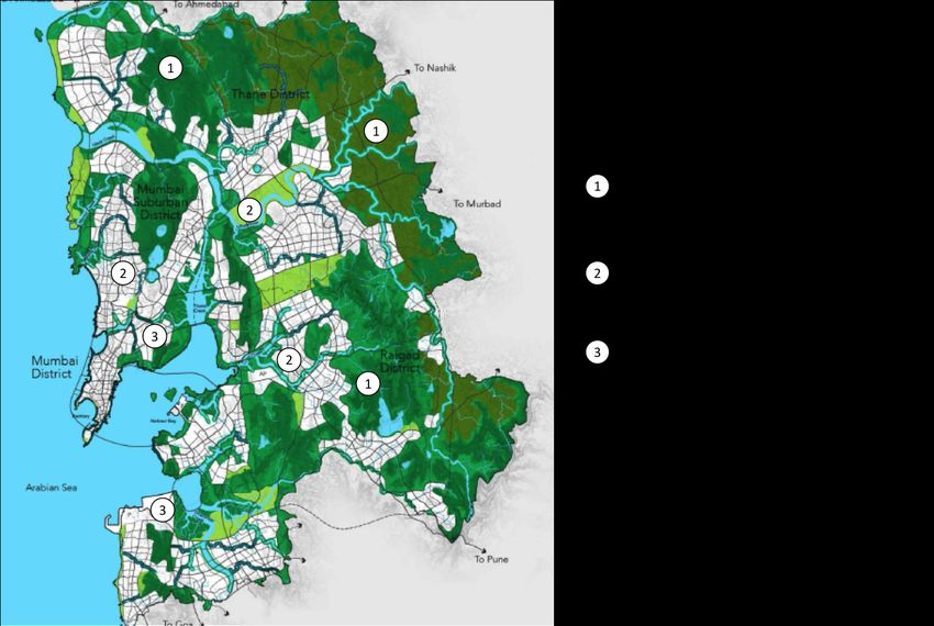
This study will focus on the three regional scale blue-green landscapes of Mumbai
Metropolitan Region to understand their values, their interrelation, their current status, the
opportunities to restore them and the constraints they face. These three typologies and
their broad geographic distribution is illustrated in the map below. These are:
1) Typology 1: Forested headwaters, Sub case- Sanjay Gandhi National Park
2) Typology 2: Rivers, streams, floodplains, Sub case- Mithi River and its flood plain
3) Typology 3: Coastal environments, Sub case- The Coastal Regulation Zone
Page 28Report MIT Mumbai, Wescoat
Map showing the geographic extend of the BGI network in the MMR region. Base Map Source: Concept
Plan for Mumbai Metropolitan Region, by Surbana
7. INSTITUTIONS AND GOVERNANCE
In Mumbai’s context it is interesting to see that both the Coastal Regulatory Zone policy
advocating a strong environmental preservation path and the Industrial relocation policy passed
in 1980’s have largely supported repurposing of city’s underused industrial infrastructure to
support environmental causes. And yet a large part of Mumbai’s Eastern waterfront continues to
be dominated by largely unregulated industrial/commercial uses on land owned by a central
government agency. This institutional analysis will focus on understanding which ideas get
implemented and what gets left out and why. What are the governance and institutional politics
and capacity issues and how those impact implementation of environmental
regulations that effect each of the typology selected for the case study. Are
national and state governance agencies in concert over environmental policies?
Why are local government agencies like Municipal Corporation of Greater
Mumbai (MCGM) and Mumbai Metropolitan Regional Development Authority
(MMRDA)being held in contempt by court for breaking national environmental regulation which
Page 29Report MIT Mumbai, Wescoat
stipulates environmentally sensitive coastal development (CRZ regulation, MOE)? What is the
regulatory environment, who formulates and who implements it, what are the pressures on local
agencies and do they have the capacity to enforce and implement policies. What would be a
more enabling environment? Who are the non-state players- civilian actors, environmental groups
who can act as watchdogs and what are their motivations. How will they influence public debate
and policy on environmental issues? Will there be public pressure to consider more
environmentally sensitive land policies.
The OUP handbook on urbanization describes these conflicting and contrasting pressures that
are shaping a polarizing environment versus development perspective in India today (Kumar and
Martinez-alier 2011). The pro development intellectuals claim that “development that meets the
needs of the present without compromising the ability of future generations, is too intellectually
neat and politically convenient an idea” (Lele, 1991, Lohmann, 1990). It suggests that a
distinction needs to be made between “survival” and “Luxury” in the context of developing
countries. The pro-environment groups contends that this stance as merely “ hiding behind the
poor” or “protecting growth” and “avoiding climate change” (Martínez-Alier 1995). Scholars have
also raised concern over the trend of “executive and or judiciary setting the environment policy to
the exclusion of the parliament”, perhaps indicating to their lack of legitimacy and lackadaisical
enforcement by local legislators. In 2009 the National Action Plan on Climate Change (GOI,
Prime minister's council on climate change) developed a co-benefit agenda. This was an
important milestone and provides a political opportunity and institutional vehicle to re-frame the
existing development debate. It established that the climate agenda in India is the governance of
multiple objectives, rather than singular objectives.
While at the macro scale environmental policies in India face a legitimacy and enforcement
challenge, at the local scale there are also many administrative challenges. The city of Mumbai
consists of 2 administrative districts: the island city and the suburban district. The Mumbai
Metropolitan Region (MMR) includes 2 more districts: the Thane district and the Raigad district.
The total area of the entire metropolitan region is 4355 sq km. The administration of the region
incorporates 8 planning corporations and 9 municipal councils and a1000 villages. 94% of
regional population is urban and 6% is rural. Mumbai city extends between 18° and 19.20° N and
between 72° and 73° E. The city extends from East to west by about 12 km, where it is broadest,
and from North to South extends about 40 km (Hallegatte et al. 2010). Geographically, Greater
Mumbai is an island separated from the mainland by the narrow Thane Creek and the relatively
wider Harbour Bay. Thus, the area of Greater Mumbai is surrounded on three sides by the seas:
by the Arabian Sea to the West and the South, the Harbour Bay and the Thane Creek in the East.
The entire Mumbai city is divides into 6 zones and 24 wards. The island city has 9 wards and the
Page 30Report MIT Mumbai, Wescoat
suburban district had 15 wards. A total of 37% of the population is employed in the formal sector
and 63% in the informal sector. The city receives on an average 2400mm of rainfall annually. The
rain falls primarily in a short period of 3-4 months during the monsoon season stretching from
June-August. Continuous rainfall during the monsoon season often results in flashfloods in many
low lying areas of the city, disrupting traffic, commerce and destroying property and causing many
hardships to its citizens.
Mumbai Metropolitan Region Map- source- MMRDA website
Page 31Report MIT Mumbai, Wescoat
MMR water management- Institutional Structure, source MCGM website
The institutional map above illustrates the hierarchical structure of the agencies responsible for
managing water supply for the greater metropolitan region, their roles are described below. The
Municipal Corporation of Greater Mumbai (MCGM) is responsible for the overall water
management within the jurisdiction of Mumbai, as a water resource developer and manager. The
City and Industrial Development Corporation (CIDCO) is responsible for water management in
Navi Mumbai. The local municipalities in Mumbai metropolitan Region purchase water from
MCGM or use ground water. The Maharashtra Jeevan Pradhikaran is a state agency that
facilitates water procurement. The MCGM has two departments responsible for water
management. The Hydraulic Engineering Division is responsible for construction, operation and
maintenance of reservoirs and treatment plants. The Water Supply Division is responsible for
service delivery, maintenance, water works, meter reading, billing and procuring municipal
appurtenances. The Mumbai metropolitan region development authority (MMRDA) prepares the
strategic regional plans for ensuring water supply during the plan time and horizon. The
Maharashtra Pollution Control Board (MPCB) sets up the regulatory framework and standards to
meet the water quality requirements for the state.
The Gardens department of MCGM develops, maintains public open spaces like gardens and
recreational grounds and playgrounds in the city of Mumbai. The department engages its own
Page 32Report MIT Mumbai, Wescoat
workforce for the purpose and also has outsourced these activities to private sponsors in lieu of
advertisement and publicity rights. MCGM maintains about 753 such open spaces admeasuring a
total of 4.4 sq km spread across the city. Though the city has regulations in place for
development of open spaces in the development plan, the regulations for acquisition of these
public spaces is not included and is cost prohibitive due to land costs.
8. MAJOR BGI CASE STUDIES IN MUMBAI
Having an overview of Mumbai’s historic geography with specific focus on the development of its
water infrastructure and its overall administrative structure and challenges. We now return to the
main BGI case studies for a detailed examination of how they developed, using the Expanded
Process Model, and what values they embody today. In contrast with urban case studies that
have only one main BGI case, here we have three: the Sanjay Gandhi National Park in the
headwaters of Mumbai’s watershed; followed by the Mithi River; and then the Coastal ecosystem.
In this section, we examine each of these in sequence from the headwaters to the ocean.
a. CASE-1- FORESTED HEADWATERS-SANJAY GANDHI NATIONAL PARK
To understand the antecedent conditions for the development of the Sanjay Gandhi National Park
as an implicit BGI we developed a historic chronology of the case. This might have relevance to
other case studies in helping inform them of the necessary political, social, environmental and
economic conditions that enabled formation of this BGI and perhaps project what could lead it to
become an explicit BGI.
i. Chronology. The chronology of the case is:
● 1845-1855- A water committee was established to protect surface water sources from
pollution and look at other sources of water north of the island city to meet the growing
water needs of the island city.
● 1865- The Indian Forest service was established under the Government Forest Act and
given the charge to manage forests across the country.
● 1868- In Mumbai the Tulsi lake was commissioned
● 1883- The Bombay Municipal Corporation acquired the forest catchment areas of the
Tulsi Lake. (10 sqkm of forest area)
● 1927- A notification was issued to designate the forest area as a protected forest under
the Indian Forest Act. This act restricted timber production and cattle grazing thus
enabling a protection and conservation mandate.
Page 33You can also read