MIOMBO ECOREGION VISION REPORT - Jonathan Timberlake & Emmanuel Chidumayo Occasional Publications in Biodiversity No. 20 - Biofund
←
→
Page content transcription
If your browser does not render page correctly, please read the page content below
MIOMBO ECOREGION
      VISION REPORT

    Jonathan Timberlake & Emmanuel Chidumayo
            December 2001 (published 2011)

Occasional Publications in Biodiversity No. 20
WWF - SARPO

 MIOMBO ECOREGION

      VISION REPORT

                      2001
               (revised August 2011)

                        by

Jonathan Timberlake & Emmanuel Chidumayo

 Occasional Publications in Biodiversity No. 20

            Biodiversity Foundation for Africa
     P.O. Box FM730, Famona, Bulawayo, Zimbabwe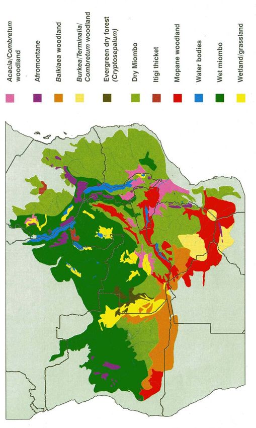
PREFACE

The Miombo Ecoregion Vision Report was commissioned in 2001 by the Southern Africa
Regional Programme Office of the World Wide Fund for Nature (WWF SARPO). It
represented the culmination of an ecoregion reconnaissance process led by Bruce Byers (see
Byers 2001a, 2001b), followed by an ecoregion-scale mapping process of taxa and areas of
interest or importance for various ecological and bio-physical parameters. The report was then
used as a basis for more detailed discussions during a series of national workshops held across
the region in the early part of 2002. The main purpose of the reconnaissance and visioning
process was to initially outline the bio-physical extent and properties of the so-called Miombo
Ecoregion (in practice, a collection of smaller previously described ecoregions), to identify
the main areas of potential conservation interest and to identify appropriate activities and
areas for conservation action.
    The outline and some features of the Miombo Ecoregion (later termed the Miombo–
Mopane Ecoregion by Conservation International, or the Miombo–Mopane Woodlands and
Grasslands) are often mentioned (e.g. Burgess et al. 2004). However, apart from two booklets
(WWF SARPO 2001, 2003), few details or justifications are publically available, although a
modified outline can be found in Frost, Timberlake & Chidumayo (2002).
    Over the years numerous requests have been made to use and refer to the original
document and maps, which had only very restricted distribution. Now, 10 years after the
original draft Vision Report was produced, we are making the report more widely available as
a Biodiversity Foundation for Africa (BFA) publication. Only minor corrections or additions
have been made to the original document, and maps from other publications have been added
in.
    Another BFA Publication (No. 21, Timberlake et al. 2011) presents a series of maps
showing the areas of biological importance, an output from a BFA consultancy.

                              ACKNOWLEDGEMENTS

We would like to acknowledge the support of WWF SARPO in Harare, particularly Fortune
Shonhiwa, Programme Office for the Miombo Ecoregion visioning process. The maps were
mostly produced by WWF's GIS Unit.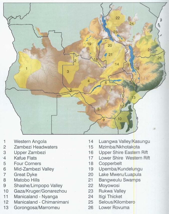
LIST OF CONTENTS

                                                                                                                                      page
PREFACE .................................................................................................................................. 2
ACKNOWLEDGEMENTS ....................................................................................................... 2
LIST OF CONTENTS ............................................................................................................... 3
1. INTRODUCTION................................................................................................................. 5
    1.1 Ecoregion Conservation ................................................................................................ 5
    1.2 The Miombo Ecoregion ................................................................................................ 6
    1.3 The Ecoregion Conservation Planning Process ............................................................ 8
    1.4 Miombo Ecoregion Vision Report ................................................................................ 8
2. PHYSICAL FEATURES AND PROCESSES ..................................................................... 9
   2.1 Extent and Physical Determinants................................................................................. 9
   2.2 Geology ......................................................................................................................... 9
   2.3 Landscape Evolution ................................................................................................... 13
   2.4 Hydrological Processes ............................................................................................... 14
          2.4.1 Rainfall Processes ......................................................................................... 14
          2.4.2 Characteristics of the Plateau Surface.......................................................... 14
          2.4.3 Spatial Distribution of Surface Water .......................................................... 15
          2.4.4 Soil–Water Processes ................................................................................... 15
   2.5 Biophysical Processes ................................................................................................. 16
3. BIOLOGICAL FEATURES AND SPECIES ..................................................................... 18
   3.1 Ecoregion Boundary.................................................................................................... 18
         3.1.1 Inclusions and Exclusions ............................................................................ 18
   3.2 Vegetation Types......................................................................................................... 20
   3.3 Species......................................................................................................................... 23
         3.3.1 Plants ............................................................................................................ 23
         3.3.2 Mammals...................................................................................................... 23
         3.3.3 Birds ............................................................................................................. 25
         3.3.4 Reptiles / Amphibians .................................................................................. 25
         3.3.5 Fish ............................................................................................................... 26
         3.3.6 Invertebrates ................................................................................................. 26
   3.4 Areas of Evolutionary Significance ............................................................................ 28
   3.5 Areas Important for Animal Movement and Migration .............................................. 28
4. ECOLOGICAL DETERMINANTS AND PROCESSES................................................... 30
   4.1 Ecological Determinants ............................................................................................. 30
   4.2 Biophysical Processes ................................................................................................. 30
   4.3 Plant Biomass and Herbivory...................................................................................... 31
   4.4 Carbon Storage and Sequestration .............................................................................. 31
   4.5 Nutrient Cycling.......................................................................................................... 32
   4.6 Fire .............................................................................................................................. 32
   4.7 Human Interactions ..................................................................................................... 33
5. SOCIO-ECONOMIC FEATURES AND PROCESSES .................................................... 34
   5.1 Socio-Economic Context............................................................................................. 34
5.2 Key Socio-Economic Features and Processes............................................................. 34
           5.2.1 Socio-Political Factors .................................................................................. 34
           5.2.3 Cultural Processes ........................................................................................ 35
           5.2.4 Land Use and Socio-Economic Development ............................................. 35
     5.3 Economic and Policy Environment............................................................................. 39
           5.3.1 Socio-economic Threats and Opportunities ................................................. 39
           5.3.2 Cross-cutting Factors.................................................................................... 40
           5.3.3 Threats.......................................................................................................... 40
           5.3.4 Opportunities................................................................................................ 42
6. CONSERVATION VISION AND AREAS OF BIOLOGICAL IMPORTANCE............. 44
   6.1 Vision Statement ......................................................................................................... 44
          6.1.1 Rationale........................................................................................................ 44
   6.2 Areas of Importance for Biodiversity Conservation ................................................... 45
7. BIBLIOGRAPHY AND REFERENCES ........................................................................... 64
Appendix 1. List of endemic or near-endemic vertebrate taxa in the Miombo Ecoregion. ..... 69
Appendix 2. Miombo Ecoregion habitats ................................................................................ 77

                                       LIST OF TABLES AND FIGURES
Figure 1. The Miombo Ecoregion and southern Africa ........................................................... 7
Figure 2. Southern Africa – physiography and altitude .......................................................... 10
Figure 3. Miombo Ecoregion – rainfall................................................................................... 12
Figure 4. Miombo Ecoregion – vegetation types .................................................................... 19
Figure 5. Miombo Ecoregion – protected areas ...................................................................... 38
Figure 6. Miombo Ecoregion – areas of biological importance.............................................. 47
Figure 7. Miombo Ecoregion – areas of significance for habitat conservation ...................... 79

Table 1. Revised Miombo Ecoregion vegetation units ........................................................... 20
Table 2. Numbers of species recorded from the Miombo Ecoregion. .................................... 27
Table 3. Protected areas within the Miombo Ecoregion ......................................................... 38
Table 4. Identified areas of importance for conservation in the Miombo Ecoregion ............. 46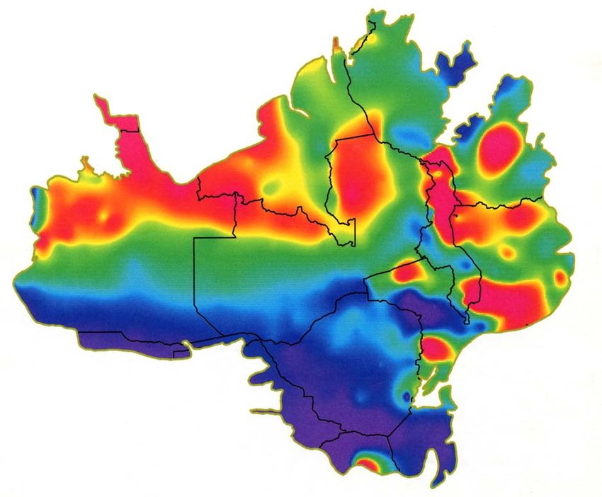
Miombo Ecoregion Report, page 5

                                   1. INTRODUCTION
The mission of the World Wide Fund for Nature (WWF) is the conservation of nature and the
promotion of sustainable use of natural resources. Historically, the strategy of WWF was largely
based on single species, often driven by the need to respond to dramatic poaching levels of well-
known animal species and to address severe cases of habitat degradation and loss all over the
world. While these campaigns were entirely legitimate, they may have inadvertently under-
emphasized some fundamental conservation imperatives such as conservation of large-scale
ecological processes, maintaining viable populations of species, addressing habitat
representativeness and ecosystem diversity. After reviewing the present challenges and lessons of
conservation projects over the last 50 years, WWF International has decided that an ecoregion
approach is the most appropriate to set conservation targets and priorities at a continental or
worldwide level. This culminated in the determination of ecoregions across the world (Olson et
al. 2001), with around 120 in Africa, and the selection of the Global 200 most important
ecoregions (WWF 1999).

As part of this approach, the WWF Southern Africa Regional Programme Office (WWF-
SARPO) has embarked on an ecoregion conservation programme for the Miombo (or Southern
Caesalpinoid Woodlands) Ecoregion. This is one of the Global 200 ecoregions, the largest of 21
on mainland sub-Saharan Africa. The ecoregion provides a good example in which management
of hydrological processes is central to maintaining its essential features, such as soil moisture
regimes, dominant vegetation cover, characteristic species and associated evolutionary processes.
In this regard, the sustainable management of water, involving the wise use of ubiquitous dambos
(broad, seasonally-inundated drainage lines on the plateau) and the protection of major river
catchments located in the deep aeolian Kalahari sands of Angola and Zambia, is crucial to
ecological functioning. The goal of this programme is to contribute to the maintenance of
biodiversity and functioning ecosystems in the Miombo Ecoregion for the benefit of people and
nature, while the purpose is to extend that part of the ecoregion where biodiversity conservation
and functioning ecosystems are fully incorporated into landuse practices, to the benefit of
conservation of both agricultural lands and wildlands.

1.1 Ecoregion Conservation
Ecoregion conservation enables WWF to take a more comprehensive approach to biodiversity
conservation without sacrificing sensitivity to local biodiversity issues and socio-economic
conditions. This larger-scale, more integrated approach enables WWF to better assess both the
proximate and root causes of biodiversity loss, and to design policy and management initiatives
at appropriate levels from international trade policies to site-specific protected area management
or community development projects. Moreover, it allows WWF to connect what it does at the
local level with what needs to be done at national and international levels, to better link field
work with policy work, and to build new partnerships in carrying this out.

An ecoregion is defined as a relatively large unit of land or water that is biologically distinct
from its neighbours, an area that harbours a characteristic set of species, communities, dynamics
and environmental conditions. It embodies the general principles of ecosystem conservation and
the major goals of conservation biology since it encompasses: (a) the representation of all
broadly distinct broad communities and species assemblages, (b) the maintenance of viable plant
and animal populations within large expanses of intact habitat, (c) special recognition of keystone
ecosystems, habitats, species and phenomena, (d) conservation of large scale ecological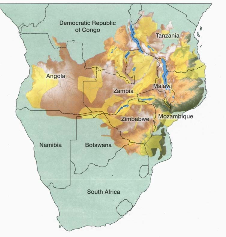
Miombo Ecoregion Report, page 6

processes, and (e) conservation of species of special concern. It differs from other approaches in
that it demands a visionary and strategic view in planning to conservation, it operates over large
temporal and bio-geographical scales, and it requires an understanding of social and biological
processes and dynamics operating at these scales. It is usually viewed in the long-term context of
50 years. The broad spatial and temporal scale adopted requires an integrated and multi-
disciplinary approach where biological units are the basis for planning and activities. As an
ecoregion unit may cross political boundaries, thinking must extend beyond national boundaries
or programmes, even though requisite conservation actions happen nationally. The challenge is
therefore to operate over these large spatial scales through coordinated and concerted actions
across political boundaries. Although with many attendant difficulties, the often cross-boundary
nature of the approach is vital to achieving long-term ecosystem conservation goals.

1.2 The Miombo Ecoregion
The Miombo Ecoregion, covering over 3.6 million square kilometres across 11 countries of
southern Africa (Figure 1), comprises dry and moist woodlands that support some of the most
important thriving large mammal populations left in Africa. Black rhinoceros, African elephant,
African hunting dog, Cheetah and the Slender-nosed crocodile are some of the threatened
species, along with many less-known species of plant, birds, reptiles, fish and insects. More than
half of the estimated 8,500 plant species in this ecoregion are found nowhere else on Earth. There
is also a distinctive bird, reptile and amphibian fauna.

One of the region's main characteristics is the presence of large expanses of rolling savanna
woodland on a gently undulating plain, interspersed with grassy drainage lines (dambos) in a
regular catenary sequence. The pattern is distinct and repetitive. It is the juxtaposition of different
vegetation types – nutrient poor and nutrient-rich woodland, areas of short nutritive grasses
interspersed with taller rank grass, wetlands in an otherwise dry environment – that allows many
of the large herbivores to survive. The herbivores move through the landscape seasonally,
making the best use of forage resources in what is generally a nutrient-deficient and low
carrying-capacity environment. In many respects, conservation of these woodlands needs to
focus on broad landscape-level processes and hydrology rather than on specific habitats or
species.

The ecoregion is typified by a dominance of deciduous woodland composed of broad-leaved
trees of the legume subfamily Caesalpinioideae. Owing to the deciduous nature of the woodland
there is a well-developed grass layer which, in turn, gives rise to frequent and wide-spreading
fires. Caesalpinoid woodlands are confined to the gently undulating, unrejuvenated Central
African plateau at an altitude of 800–1200 m, although they come down to the coastal plain in
Mozambique and Tanzania. The ecoregion is incised by the large river valleys of the Zambezi,
Luangwa and Limpopo, and by the Rift Valley lakes of Tanganyika and Malawi. A number of
major drainage basins such as the Zambezi, Limpopo, Save, Cuando, Kavango, Rufiji, Rovuma
and Luapula (part of the Upper Congo) are incorporated.

Although the ecoregion is commonly termed the Miombo Ecoregion, this is confusing as the
Caesalpinoid woodlands which it comprises extend significantly beyond true miombo woodland.

A unimodal rainfall pattern with distinct and prolonged dry seasons, coupled with the generally
leached and impoverished soils, are major features. It is the combination of environmental
factors– rainfall, length of dry period, soil nutrient status and fire – which is the probable main
determinant of woodland limits and separates this from adjacent ecoregions.

Miombo Ecoregion Report, page 7

           Figure 1. The Miombo Ecoregion and southern Africa (from WWF SARPO 2003).

The primary and direct impacts on the ecoregion come from the large and rapidly growing
human population and its demand for agricultural land. Large areas of dry woodland, unlike
moist forests, can be more easily converted to agricultural land owing to the lower above-ground
woody plant biomass, though the social and environmental consequences are probably as
profound as with moist forest.

Most of the miombo savanna woodlands are inhabited, and there are few areas that can be
considered at all pristine. Many rural people depend heavily on natural resources for their
livelihoods. These conditions have led to a strong emphasis on the sustainable use of natural
resources in the region, and on Community-based Natural Resource Management (CBNRM)
programmes. The region is considered by many to be a global model for CBNRM. As other
organisations besides WWF are involved in natural resources management and conservation
initiatives within the ecoregion, WWF's planning process will require collaboration with a range
of partners.

The Miombo Ecoregion is exceptionally large compared to many others, and also diverse.
Although it can be split into a number of sub-regions (for example, Burgess et al. 2004), it was
felt that its integrity should be retained, as it is this that gives rise to its uniqueness and
importance. In some ways it could be said that conservation of the Miombo Ecoregion is more
about conservation of processes operating at a landscape scale across thousands of square
kilometres than about conservation of species or individual habitats.
Miombo Ecoregion Report, page 8

1.3 The Ecoregion Conservation Planning Process
The first step in the ecoregion conservation planning process is a reconnaissance to outline the
current state of biological and socio-economic knowledge for the area and to identify major gaps.
This stage involves a certain amount of data gathering and assessment. The reconnaissance also
seeks to identify major factors influencing environmental change and loss of biodiversity, to
identify key problems and opportunities for conservation interventions, and to provide a basis on
which to plan a more comprehensive biological and socio-economic assessment.

Both the reconnaissance and subsequent assessments provide the basis for developing a
biodiversity conservation vision. The vision should set out long-term goals for conservation of
the ecoregion's biodiversity, identify key sites, populations and ecological processes. It should
guide the development of the action plan and any strategic decisions as circumstances and
opportunities change. This is followed up by the development of a conservation action plan.
The action plan sets the 10 to 15 year goals for conservation of the ecoregion's biodiversity, and
identifies the actions needed to achieve those goals. It is a comprehensive blueprint for
conservation action, and identifies the first steps on the road to achieving the vision.

1.4 Miombo Ecoregion Vision Report
This report has built upon the reconnaissance process and vision building workshop to produce a
biodiversity vision. This vision is essentially a statement coupled with a series of biologically
important areas that have been identified for special attention. These areas have been identified
and mapped, and are described in this report. The expectation is that if we concentrate our
conservation efforts on them with full recognition of the goals of biodiversity conservation, we
should eventually realize our long-term biodiversity vision.

The Vision Report is a further step in the ecoregion planning process. It has built upon the
reconnaissance process but has advanced by producing a set of biologically important areas
across the ecoregion in a participatory process that involved biologists and socio-economic
experts. These areas represent overlaps in the occurrence and distribution of key taxa, species and
genera and in some cases, ecological processes. Boundaries of some of these areas are still
tentative, hence further refinement and detailed biological and associated socio-economic
assessments will be needed, along with identification of opportunities for conservation.

The major ecological processes identified during the reconnaissance and vision workshops have
also been described, as are the major socio-economic opportunities and threats. It is worth stating
that in this process an attempt was made to map out socio-economic processes, which will need
to be seriously considered in the construction of conservation action plans.

The report sets out to give an overview of the Caesalpinoid Woodland (Miombo) Ecoregion, and
to describe its boundaries, biological and socio-economic attributes. Particular attention has been
given to species diversity, regional endemism, global significance and to the ecological processes
that both underpin and unify the ecoregion. Suggestions for further necessary short-term
activities are also described.
Miombo Ecoregion Report, page 9
2. PHYSICAL FEATURES AND PROCESSES
2.1 Extent and Physical Determinants
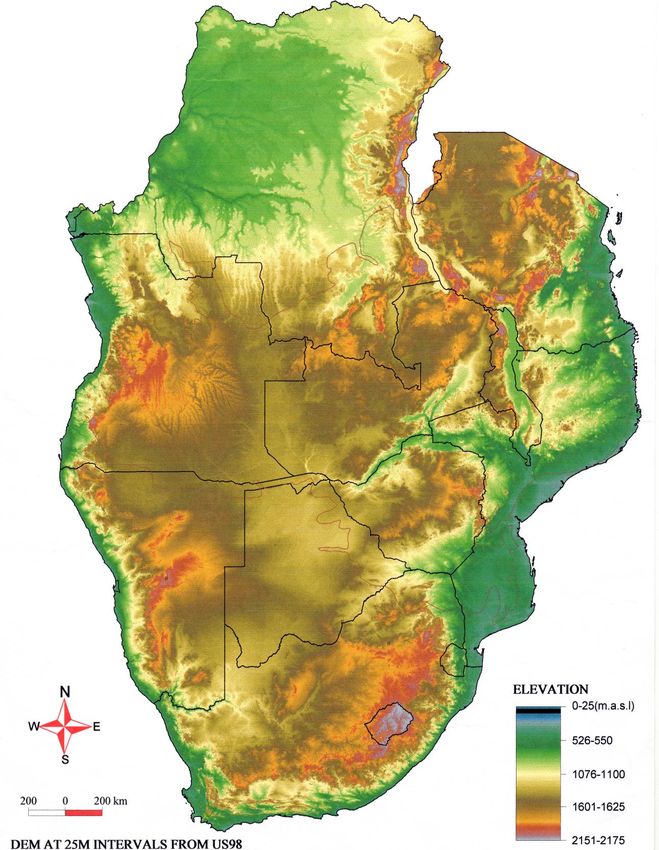
The Miombo Ecoregion covers over 3.8 million km2 in central and southern Africa, extending
from the west coast in Angola to the east coast in Mozambique and Tanzania. It includes all or
part of 11 countries – Angola, Namibia, Botswana, South Africa, Zimbabwe, Zambia,
Democratic Republic of Congo (DRC), Mozambique, Malawi, Tanzania and Burundi. Much of
the ecoregion is on the ancient African plateau with an altitude of 800 to 1250 m above sea level,
but in the east the ecoregion transcends the escarpment and elements of the ecoregion can be
found in the east African coastal zone, at 200 to 300 m altitude (Figure 2). In spite of the
favourable elevation, the biological elements of the ecoregion give way to other biomes in the
northeast, south and southwest. Elevation therefore does not fully determine the Miombo
Ecoregion boundary.
Overall, the Miombo Ecoregion boundary appears to be determined by the interaction of
topography, precipitation and temperature. Climate is probably the most important determinant.
The ecoregion occurs in the unimodal rainfall zone, except in the northeast in central Tanzania
where rainfall tends to be bimodal. Mean annual rainfall is in the range of 600 to 1400 mm
(Figure 3) and occurs from November to April. To the northwest, the boundary roughly follows
the 1400 mm isohyet while to the northeast and south, the boundary follows the 600 mm isohyet.
It is obvious that the biological elements of the ecoregion are ill-adapted to humid and arid
conditions. In central and southern Africa both humid and arid conditions are associated with
mean maximum temperatures higher than 30oC. Much of the region therefore lies in the warm
subhumid zone with a mean maximum temperature of 24–27oC.
2.2 Geology
The geological foundation of much of south and central Africa consists of large, stable, Archaean
crustal blocks called cratons, of relatively low metamorphic grade, separated by broad zones of
more highly metamorphosed rocks known as mobile belts. The cratonic nuclei include the
Congo, Tanzania, Kaapvaal and Zimbabwe cratons; dating indicates a long and complex
geological history and gives ages ranging from around 3500 to 2600 million years (Ma). Cratonic
stabilisation did not occur everywhere at the same time. In the Zimbabwe craton, which is the
best exposed, some early stabilisation had been effected by 3300 Ma with final stabilisation at
about 2600 Ma, accompanying the emplacement of vast volumes of potassium-rich granites.
The cratons now consist of the deformed remains of volcano-sedimentary piles (greenstone belts)
intruded by various, and numerous, granites. Metamorphic grade in the greenstone belts is such
that primary textures and structures are often well preserved and the primary nature of the rocks
is clear. For example, basaltic lavas dominate the volcanic pile and numerous examples of
pillows indicate that eruption occurred under water. Also pockets of limestone, although now
recrystallised, show fossil stromatolites in places indicating that, here at least, water depths were
shallow. Typically, the basaltic greenstones weather to give fertile, reddish soils. Prominent
among the associated chemical sediments are banded iron formations and ferruginous cherts,
which often outcrop as prominent well-wooded ridges.Miombo Ecoregion Report, page 10 Figure 2. Southern Africa – physiography and altitude.
Miombo Ecoregion Report, page 11

The mobile belts range from late Archaean to early Palaeozoic, with age groupings around 2700
Ma, 2000–1800 Ma, 1400–1100 Ma and 950–450 Ma. In places they show evidence of
metamorphism and deformation of more than one age. Rocks include granitic gneisses,
metasediments and metavolcanics all at high metamorphic grade. Perhaps the oldest of these, the
well-documented but still enigmatic Limpopo Belt, separates the Zambezi craton from the
Kaapvaal craton to the south. It consists of a central zone of Archaean metasediments, with a
major development of quartzites, flanked to the north and south by high grade rocks of the
adjacent cratons. Metamorphism and tectonism is late Archaean, at around 2700 Ma, followed by
a second, early Proterozoic, phase at 2000 Ma.

Emplaced at 2580 Ma, and affording a magnificent marker for the end of the Archaean and the
beginning of the Proterozoic, is the Great Dyke of Zimbabwe. Funnel-shaped in cross-section in
its present erosion plane, it is not a true dyke but a NNE-trending line of contiguous, elongate,
mafic/ultramafic, layered intrusions that almost bisects the craton. Gabbroic rocks form the upper
part and ultramafic rocks, mainly pyroxenite and dunite, the major and lower part of the layered
sequences. Weathering of the dunite has produced a surface serpentisation and nickel-rich soils
that characteristically support unique, nickel-tolerant vegetation.

Proterozoic sedimentary and volcanic rocks of various ages occur intermittently overlying the
Archaean cratons. Most of these extend into the marginal Proterozoic mobile belts to become
highly deformed and metamorphosed; in places they have also been thrust over the adjacent
cratons during the deformation. Among these is the early Proterozoic Magondi Supergroup of
basalts, quartzites, dolomitic marbles and metapelites, deposited on the NW side of the
Zimbabwe craton. Orogeny around 2000–1800 Ma produced the Magondi Mobile Belt, involving
the deformation of the Magondi rocks and underlying basement. On a larger scale, this is part of
more widespread orogenic events affecting southern, central and eastern Africa at this time. On
the northern flank of the Zimbabwe craton, the various metasediments and infolded basement of
the Zambezi Belt were extensively deformed around 850 Ma. The belt cuts across the earlier
Magondi Belt and extends west into southern and central Zambia to the Copperbelt. Eastwards it
links with the N-trending Mozambique Mobile Belt, which straddles Zimbabwe's eastern
international border with Mozambique and extends northwards as a major structural zone into
Zambia, Tanzania and Uganda. In eastern Zimbabwe, the late Proterozoic Umkondo Group
forms a cratonic cover of quartzites, shale and minor volcanics, and extends eastwards to become
an integral part of the Mozambique Belt.

Cratonic granite-greenstone terrains, mobile belts and cratonic cover rocks together form the
Precambrian Basement platform on which the Phanerozoic rocks were deposited. This basement
is host to economically important minerals – gold in the Archaean greenstone belts; chromitite
and platinum group minerals in the Great Dyke; and copper in the Proterozoic, especially in the
Copperbelt of Zambia and Katanga Province of the DRC.

The most conspicuous rocks of Phanerozoic age in south and central Africa belong to the Karoo
Supergroup. These were deposited on Gondwanaland from the late Pennsylvanian (Upper
Carboniferous) to Jurassic Periods, a span of some 100 Ma, as this giant continent moved slowly
across the South Pole and thence northwards to straddle the Equator before splitting to form the
continents that are familiar today. The sequence of sedimentation in the intracontinental basin,
from all the modern component fragments, reflects the steadily changing climate from frigid to
cool temperate to warm temperate to hot desert. Finally, cracks opened across Gondwanaland
and permitted the eruption of the vast numbers of basalt flows that constitute the uppermost part
of the Karoo Supergroup. Thereafter the modern continents moved to their present positions.
Miombo Ecoregion Report, page 12

In Africa, Karoo rocks can be traced from extensive areas across South Africa to Namibia,
Botswana, Zimbabwe (particularly Matabeleland and the Zambezi Valley), Zambia and small
patches in Malawi, Tanzania and Kenya. Lower Karoo rocks, deposited during the glacial and
cool temperatures, are principally shales and sandstones with coal derived from Glossopteris
flora. The basal formation is a tillite, which commonly rests on a glaciated pavement – the Pre-
Karoo erosion surface.

                    Figure 3. Miombo Ecoregion – rainfall.

Upper Karoo sediments are lighter-coloured grits, sandstones, shales and mudstones that contain
Permian therapsids, Triassic dinosaurs and a variety of plant fossils. Some of the finer grained
rocks are highly erodible, and in certain localities in Hwange National Park, the floor of the
Zambezi Valley and south of Harare exhibit spectacular gully and sheet erosion. The basalts can
be seen today in Lesotho, the Limpopo Valley, Victoria Falls and smaller outliers elsewhere.

The break-up of Gondwanaland produced new coastlines along the eastern and western margins
of Africa, and Cretaceous and Cainozoic times are recorded by littoral sediments associated with
shoreline fluctuations. In the hinterland, however, the Kalahari and Congo basins have been the
loci of continental deposition. The most recent deposits are the Kalahari Sands which date from
the Miocene Epoch and which have been blown repeatedly, in various directions, until the
present day. Deposits of these sands now occur far beyond the present Kalahari region, in
scattered patches through Zimbabwe and Zambia, and locally provide the uppermost soil for the
Miombo Ecoregion. The underlying geology of the ecoregion covers a wide spectrum of rock
Miombo Ecoregion Report, page 13 types ranging in age from Archaean onwards but, in itself, does not control the distribution of the Caesalpinoid woodlands. 2.3 Landscape Evolution The landscapes in the Miombo Ecoregion are dependent mainly on the geology, climate and drainage, and usually have taken many millions of years to reach the present-day stage. The geological control is effected by the relevant resistance to weathering that the different rock types exhibit. Thus more resistant rocks, such as sandstones, quartzites and ironstone formations, are located along ridges and other high-standing areas, whereas soft rocks, such as shales and mudstones, occur in low-lying positions. Certain rock types weather to characteristic landforms. For example, the granite terrain, seen widely across Africa, shows curved exfoliated domes (bornhardts) and rectangularly jointed blocks (tors and inselbergs). Climate controls both temperature and rainfall, the latter producing the water essential for chemical weathering. Much of southern Africa, including the Miombo Ecoregion, experiences a marked dry season – wet season climatic regime, which leads to pediplanation as the dominant geomorphic process. Drainage governs the movement of water and soil particles to lower levels, ultimately to sea level. Incision of the river valleys provides the original 'notch' on the ground surface, from which pediplanation can advance. Pediplanation entails the retreat of hill slopes as rock is weathered and removed from the steepest slopes, with resultant advance of the lower pediment and concomitant diminution of the higher pediment. With the passage of time the areas at the higher level are reduced to become residuals (inselbergs) while the lower pediments coalesce to form pediplains (erosion surfaces). The erosion surfaces that can be traced throughout Africa south of the Sahara are: Pre-Karoo (300– 200 Ma), Gondwana (170–135 Ma), Post-Gondwana (135–100 Ma), African (100–24 Ma), Post- African (24–5 Ma), Pliocene (5–2 Ma) and Quaternary (
Miombo Ecoregion Report, page 14

2.4 Hydrological Processes
A large part of the ecoregion is drained by the Zambezi River system that discharges into the
Indian Ocean through Mozambique. Other rivers draining into the Indian Ocean are the Rufiji
and Rovuma in southern Tanzania and Save and Limpopo in Zimbabwe and Mozambique. In the
northwest the ecoregion is drained by the Congo River, the headwaters of which comprise the
Chambeshi–Bangweulu–Luapula system in northern Zambia. The gradient in the headwaters of
the Congo and Zambezi is low and extensive floodplains and swamps occur, such as the Bulozi
floodplain in western Zambia, Bangweulu swamps, Lukanga swamps and Kafue Flats in central
Zambia. The Luangwa is an exception, with its steeper gradient. Consequently there are no
significant swamps along the Luangwa River. The tailwaters of the major rivers draining into the
Indian Ocean have steeper gradients and therefore have fewer, if any, expansive wetland areas,
apart from in their deltas which are outside the ecoegion.

The distinctive drainage and hydrological characteristics are determined by three factors: the
seasonal distribution of rainfall, the spatial distribution of surface water and the gradient of the
plateau surfaces.

2.4.1    Rainfall Processes

The three main airstreams affecting the rainy season in the ecoregion are the Congo airstream,
the south-east trades and the northeast monsoons (Davis 1971). The Congo air originates partly
from the southeast trades of the South Atlantic ocean which curve inland over the Congo Basin
as they approach the equator and reach the Miombo Ecoregion from the northwest. This air
stream is very humid in its lower levels and can produce widespread rain when subjected to
convergence. The south-east trades of the south Indian Ocean hold more moisture during the
summer months (November to April) and bring rains to the northeastern portion of the ecoregion,
especially in Tanzania where rainfall tends to be bimodal. The northeast monsoon originates in
the Asiatic high pressure system and may bring rain to the eastern portion of the ecoregion in
summer.

Most of the rainfall occurs near the margins of the Inter-Tropical Convergence Zone along the
Congo Air Boundary and at the northern limit of the southeast trades. Consequently, rainfall
decreases from north to south across the ecoregion, except for areas at higher altitude and those
in the proximity of lakes and swamps, both of which receive above-average rainfall compared to
the surrounding areas. The rainy season is about 200 days in the north and 100 days in the south
and valleys, such as the mid-Zambezi. However, there are substantial annual variations in the
duration and amount of rainfall.

2.4.2    Characteristics of the Plateau Surface

The gently sloping plateau landscape that characterises the ecoregion has given rise to a sluggish,
very widely-spaced drainage system. Drainage of the low plateau interfluves is probably effected
mainly by sheet flow. Infiltration may account for a considerable proportion of the rainfall,
especially in areas of Kalahari sands in the southwestern portion. The characteristic feature of the
drainage in the headwaters of the plateau streams is the broad, shallow linear depressions known
as dambos which may retain water and maintain streamflow well into the dry season. Dambos
cover 10 to 15% of the area in the headwaters of the Zambezi and Congo, and about 5% in the
middle waters of the Zambezi (Byers 2001a). The sluggish drainage has also given rise to
Miombo Ecoregion Report, page 15

expansive wetlands in the headwaters of the major rivers that are important habitats for wildlife
and fish.

2.4.3    Spatial Distribution of Surface Water

One characteristic feature of rainfall of the ecoregion is its high inter-annual variability. The
coefficient of variation which is a measure of this variability decreases with increase in rainfall.
Thus areas with low rainfall have highly variable rainfall. This coefficient varies from 35% in the
southern parts of Zimbabwe that receive about 400 to 600 mm per year, to 25% along the central
watershed which receives 700 to 900 mm per year. In Zambia the coefficient of variation ranges
from 30% along the mid-Zambezi valley to 15% in the northern high rainfall belt. Most of
Malawi has a coefficient of variation between 20 and 25%.

Because of seasonal rainfall (November–April), peak flow occurs during February in the
headwaters of the major rivers and as late as May in the tailwaters, well after the end of the rainy
season. Most small streams dry up during the dry season while in larger streams flow is a small
fraction of the wet season discharge. As there is virtually no rainfall in the dry season,
streamflow is maintained by baseflow. Rainfall that contributes to streamflow and ground water
recharge decreases from north to south across the ecoregion. Most of the discharge of the main
rivers draining into the Indian Ocean is therefore derived from the wetter northern parts and is
crucial to the maintenance of the East African Coast Ecoregion.

2.4.4    Soil–Water Processes

The plateau soils in the Miombo Ecoregion are of eluvial origin on basement quartzites, schists
and granitic rocks. They are heavily leached and are poor in nutrients due to low organic matter,
nitrogen and phosphorus content. This has arisen partly because of the poor acidic bedrock from
which these soils are derived and partly due to the long period of weathering and leaching. These
nutrient poor (dystrophic) soils have a low pH and high iron-aluminium toxicity, and range from
sandy loam to sandy clay. As a result of the eluviation process, the clay content in the soil
increases with depth, although most soils are generally shallow with a lateritic horizon. In areas
of active erosion, such as escarpments, the topsoil is continuously removed, thereby exposing the
lateritic material and/or bedrock.

Topsoil (0–30 cm) moisture content varies from 50–70 cm) moisture content remains >10% throughout the year
(Chidumayo 1997). This seasonality in topsoil moisture has implications for primary production
by shallow-rooted plants. Plateau soils also show a fertility gradient from the high rainfall areas
with poorer soils in the north to areas with low rainfall and relatively more fertile soils in the
south.

Low-lying areas, such as valleys, are run-on areas and have alluvial soils that are relatively more
fertile (eutrophic). Landscape heterogeneity in the ecoregion has created a gradient in soil
fertility between plateau landscapes and their adjacent valleys. Although low-lying areas receive
less rainfall, this is augmented by run-off from the surrounding escarpments and/or plateaux that
also sustains the alluviation process. Soil moisture regimes and fertility status are thus more
favourable for primary production in valleys. This edaphic gradient also occurs at intermediate
scale on the plateau landscapes where run-off from interfluves improves the soil moisture regime
of run-on areas, such as dambos. At a small-scale, termite mounds also discharge run-off onto the
surrounding area thereby creating mounds with deficient soil moisture, especially in drought
years. Mound-building termites move the subsoil that has a higher clay content onto the land
Miombo Ecoregion Report, page 16

surface. Because of this engineering work, termite mounds have soils that are more clayey than
those of the surrounding areas, although their nutrient status may not necessarily be higher. All
these soil-water processes create heterogeneity at different landscape scales and produce a variety
of habitats in the Miombo Ecoregion that support differing biological communities.

2.5 Biophysical Processes
Although the major tectonic processes on the Central African plateau ended more than 2 million
years ago, geomorphological processes are still active today in the ecoregion and are controlled
primarily by rainfall (Cole 1963). Geomorphological processes are continuously modifying the
relief and drainage, soils and micro-climate, thereby creating conditions more favourable for
some plants and less favourable for others. In turn, this brings about the extension of some
vegetation communities and the recession of others of which only relicts may remain in the
future. The Central African plateau of the Miombo Ecoregion is being dissected in ongoing
erosion cycles, especially at its edges, but also within itself. It is these processes that trigger the
ever-changing composition of vegetation communities in the ecoregion and have implications for
the conservation of biodiversity, especially in the face of climate change.

Early hominids in Africa used fire at least 1.5 million years ago (Goldammer 1991) and have
ever since acted as a dominant ecological factor influencing vegetation. The earliest positive
evidence of the use of fire by man in central Africa is dated more than 53,000 years ago (Clark
1959). It is also argued that during the 1800 years since the Iron Age man occupied the Miombo
Ecoregion, vegetation changes have been brought about mainly through the burning and
cultivating activities of man (West 1971).

Fires in the Miombo Ecoregion occur regularly and frequently and originate from people
preparing land for cultivation, collecting honey or making charcoal. Some fires are set by
hunters, either to drive animals or to attract them later to the grass re-growth areas that were
burnt, and by livestock herders to provide a green flush for their livestock and to control pests,
such as ticks. Generally, people use fire to clear areas alongside paths connecting rural
settlements. Such practices have probably been carried out for millennia. The fires occur
throughout the dry season but most occur from July to October (Chidumayo 1997) and are
fuelled largely by grass and woody plant leaf litter. Fire intensity is therefore linked to grass
production in the previous rainy season, intensity of grazing and extent of woody plant cover.
Fires tend to be more frequent and intense in areas of low woodland cover, medium to high
annual rainfall, low grazing and low to medium human population density.

Palaeo-fire regimes have varied with the influence of climate and man. It is difficult therefore to
draw a general prehistoric fire regime in the Miombo Ecoregion. Even the present-day fire
regime is difficult to define from objective data because direct field observations are too scarce
and scattered, while satellite determination of fire and burned areas is still not able to give a good
regional view of the phenomenon throughout the year (Delmas et al. 1991). At local scale fire
return periods range from 1 to 2 years, but at regional scale this is estimated at 3 years (Frost
1996).

The impact of fire on vegetation depends on the intensity and timing in relation to plant
phenology. Intensity varies with time of burning and amount of fuel. Late dry-season (August–
November) fires are more intense and destructive than fires in the early dry season (April–July)
when much of the vegetation is green and moist. Usually fire intensities in the late dry season are
Miombo Ecoregion Report, page 17

5–18 times those observed for early dry season fires (Frost 1996). Late dry season fires are also
more destructive because they occur when trees have flushed.

Response to fire is variable among tree species. The extremes of the response continuum are
defined by intolerant species that cannot survive fire, and are therefore are restricted to fire
protected areas, and fire-tolerant species that survive regular intense fires. The trees of evergreen
forests (e.g. Cryptosepalum, swamp and riparian forests), are nearly all highly intolerant of and
easily damaged by fire, but trees in frequently burnt savanna vegetation in medium to high
rainfall areas, including Brachystegia and Julbernardia species, are all fire tolerant. However, it
is also true that all trees and shrubs will eventually be eliminated from savanna vegetation if the
fires are sufficiently intense, and repeated during the late dry season over a sufficient number of
years (West 1971). Under such conditions, the woody plants that persist are only those species
which survive fire by underground tissues, from which they are able to re-sprout after fire during
the next growing season. Grassland, in areas where edaphic conditions permit tree growth, is the
ultimate product of fire because it is composed of plants most tolerant of fire. These plants are
characterised by aerial parts that die off seasonally in the dry season and/or have dormant buds
that are protected from fire damage by soil (geophytes and hemicryptophytes), or dead tissues
just above the soil surface (chamaephytes) such as leaf bases or bulbs. Thus fire can cause
changes in species composition and structure of vegetation. Frequent late dry-season fires
eventually transform forest or woodland into open, tall grass savanna, with only isolated, fire-
tolerant canopy trees and scattered smaller trees and shrubs (e.g. chipya vegetation). In contrast,
woody plants are favoured by both early burning and complete fire protection. Fire therefore is
one of the key ecological factors in Miombo Ecoregion and its management has considerable
implications for biodiversity conservation.
Miombo Ecoregion Report, page 18

                      3. BIOLOGICAL FEATURES AND SPECIES

3.1 Ecoregion Boundary
The revised Miombo Ecoregion, also termed the Southern Caesalpinoid woodlands, is an
amalgamation of a number of the smaller ecoregions shown on the WWF-US Conservation
Science Programme map "Terrestrial Ecoregions of Africa" (WWF 1999). It is a broad,
heterogeneous region that covers a large part of south-central Africa, but with many internal
similarities and links. In many respects the revised Miombo Ecoregion can be considered a
"super ecoregion" or biome.

This super-ecoregion is a broader unit than true miombo woodland (defined as woodland
dominated by trees of the genera Brachystegia, Julbernardia and Isoberlinia with a well-
developed grass layer), and is defined by the dominance (or high frequency) of trees belonging to
the legume sub-family Caesalpinioideae, such as Brachystegia, Julbernardia, Isoberlinia,
Baikiaea, Cryptosepalum, Colophospermum and Burkea. Its distribution and subdivisions are
shown in Figure 4.

White's original vegetation map (White 1983) was used as a basis for the revision, modified
using a number of national and regional studies1. The final map closely follows the boundaries of
the White's Zambezian Regional Centre of Endemism, except for the transition to the Guinea-
Congolia and Zanzibar-Inhambane phytochoria. It also broadly corresponds to the broad-leaved
dystrophic savanna woodlands of southern Africa (Huntley 1982).

The revised Miombo Ecoregion extends from the upper edge of the Angolan escarpment in the
west to the beginnings of the coastal woodlands and forests of Mozambique and Tanzania in the
east (Southern Zanzibar–Inhambane coastal forest mosaic of Burgess et al. 2004), although it
does not include those types. To the west and southwest it is bounded by Kalahari Acacia
woodlands in Namibia and Botswana (Kalahari Acacia–Baikiaea Woodlands of WWF, in part),
and to the south by Highveld grassland and mixed Acacia woodland in South Africa (Highveld
Grasslands of WWF). To the north it grades into Guinea-Congolian moist evergreen forest of the
Congo Basin (Southern Congolian Forest–Savanna Mosaic of WWF), while in the north-east it is
bounded by dry Acacia-Commiphora bushland in Tanzania (Southern Acacia–Commiphora
Bushlands and Thickets of WWF). Nomenclature of the revised units is quite different from that
of the original WWF map, and in many cases the units are substantially different. A comparison
with the WWF-US Ecoregion map is given in Table 1. The total area of the Miombo ecoregion
(excluding water bodies and mountains) is 3,649,568 km2.

3.1.1     Inclusions and Exclusions

Although within the geographical extent of the southern Caesalpinoid woodlands, Afromontane
forests and grassland (units 76, 77, 78, 80 (part) of WWF) are excluded from the biological and
other descriptions of the ecoregion. Their ecology and species composition are very different.
Also excluded are large water bodies such as lakes Kariba, Malawi and Tanganyika have been
excluded.

1
 National and regional studies used were: Acocks 1975, Barbosa 1970, Bekker & de Wit 1991, Giess 1971, C. Hines
(pers. comm. 2002), Low & Rebelo 1998, Mendelsohn & Roberts 1997, Mendelsohn et al. 2000, Pedro & Barbosa
1955, Timberlake et al. 1993, Timberlake et al. 1994, Wild & Barbosa 1967.
Figure 4. Miombo Ecoregion – vegetation types (from WWF SARPO 2003).
Miombo Ecoregion Report, page 19Miombo Ecoregion Report, page 20
Edaphic grasslands, floodplains, dambos and wetlands are, however, included within the revised
ecoregion. They are considered to be an integral part of the woodland landscape and ecological
processes, and functionally are not separable.
2
Table 1. Revised Miombo Ecoregion vegetation units.
Vegetation unit WWF (1999) unit area (km2)
Itigi thicket 48 15,405
Cryptosepalum dry forest 32 37,908
Wet miombo woodland 49 (most), 50 1,358,175
Dry miombo woodland 52, 53 1,214,533
Burkea–Terminalia woodland 57 (part) 96,162
Mopane woodland 54 (part), 55 (part) 384,037
Baikiaea woodland 51, 58 (part) 260,171
Acacia–Combretum woodland 54 (part) 103,887
Wetland grasslands 56 (part), 63 179,290
Other areas (not part of ecoregion), e.g. water 167,636
bodies, mountains
TOTAL 3,817,204
3.2 Vegetation Types
The two characteristic features of the Southern Caesalpinoid Woodland Ecoregion are the
presence of woodland dominated by trees from the legume subfamily Caesalpinioideae, such as
Brachystegia, Julbernardia, Isoberlinia, Baikiaea, Cryptosepalum, Colophospermum and
Burkea, and the presence of a well-developed grass layer composed of C4 grasses. Caesalpinoid
woodlands are composed of pinnate broad-leaved tree species, most being deciduous for at least
a short period each year, the seasonality being related to a period of water stress and/or low
temperatures. The woodland canopy is from 6 to 20 m in height, and ranges from 20% cover to
almost closed-canopy forest.
Caesalpinoid woodlands are mostly found on nutrient-poor soils (except Colophospermum and
Acacia–Combretum woodland). Vegetation composition and structure are determined by climate
(rainfall amount, length of dry season, mean temperature, frost), position in the landscape and
soil type. Most changes in vegetation type within the ecoregion are gradual. Fire is an important
feature.
Another characteristic feature is the presence of large termite mounds, especially where sub-soil
drainage is impeded. These are composed of cation-rich (particularly calcium) soils owing to
their high clay contents, and generally have lower soil moisture levels. Termitaria support very
different species from the surrounding woodlands. Their presence, as nutrient-enriched 'islands',
is of major significance for both species diversity and woodland ecology.
2
Areas taken from version of original hand-drawn map of Timberlake, digitized by WWF SARPO GIS Unit in 2001.Miombo Ecoregion Report, page 21 The main genera of Caesalpinoid trees have explosively-dehiscent pods and seeds that are not distributed far. Genera dominant in wet and dry miombo vegetation are mostly ectomycorrhizal (they have symbiotic fungi associated with the root cortex), a feature often associated with impoverished phosphorous-deficient soils (Högberg 1986, Högberg & Piearce 1986) and forest trees, while the genera dominant in Baikiaea, Burkea–Terminalia, mopane and Acacia– Combretum woodlands are all endomycorrhizal (fungal hyphae penetrate the root cells), which is much more common in the tropics. Caesalpinoid woodlands are tolerant of significant damage from drought, fire, frost and megaherbivore browsing, as most of the major trees can readily coppice. This distinguishes them from moist forests and from Acacia savannas which reproduce and recover more readily from seed. The ecoregion is divided into nine major vegetation or habitat types, each with a distinctive ecology and species composition. Itigi-like thicket: Dry deciduous forests are found in the north east (the Itigi thickets of Tanzania and Zambia), dominated by Baphia and Combretum species and Bussea massaiensis. Further south, in the Zambezi and Shire valleys, there are similar thickets characterised by early- deciduous Combretum shrubs and scattered emergent deciduous or evergreen trees. In places Xylia torreana forms a canopy. Many of these thicket patches are too small to map at the present scale. They are of significant conservation interest owing to their limited extent. Cryptosepalum dry forest: Dry evergreen forest dominated by Cryptosepalum exfoliatum is found on Kalahari sands associated with the upper Zambezi in western Zambia. Other typical species include Parinari excelsa and Marquesia species, often with lianas. Although the forest is evergreen, the type is clearly distinct from the moist forests of the Congo Basin. Annual rainfall is around 900 mm. Wet miombo woodland: A species-rich woodland with a canopy usually greater than 15 m high. Dominant species include Brachystegia floribunda, B. glaberrima, B. taxifolia, B. wangermeeana and Marquesia macroura. Annual rainfall is reliable and usually more than 1000 mm, but less in areas on Kalahari sands. The herbaceous layer comprises tall grasses such as Hyparrhenia. In the wettest areas the dominant trees are only briefly deciduous, the canopy is almost closed, and shade-tolerant species (e.g. from the family Rubiaceae) are found in the understorey. A number of floodplains and swamp grasslands are found along major rivers such as the Zambezi, Kafue, Chambeshi and Kilombero, as well as extensive dambos on the gently undulating plateau. Within wet miombo there are inclusions of "chipya", an open non-miombo formation with very tall grass and a high complement of evergreen species. This is thought to have been derived from forest patches through fire, and is found on richer soils. Dry miombo woodland: This type is floristically poorer than wet miombo with Brachystegia spiciformis, B. boehmii and Julbernardia globiflora dominant; B. floribunda is generally absent. The canopy is generally less than 15 m in height and trees are deciduous for a month or more during the dry season. Species of Acacia are found on clay soils in drainage lines. Annual rainfall is less than 1000 mm and less reliable than further north. The herbaceous layer consists of medium to tall C4 grasses. In drier areas, Julbernardia and Combretum become dominant. There is an extensive area on Kalahari sands in central Angola dominated by thicket-forming Brachystegia bakeriana, which appears transitional to Baikiaea woodland.
You can also read