Yellagonga Regional Park - Management Plan 2003-2013 - MANAGEMENT PLAN 48
←
→
Page content transcription
If your browser does not render page correctly, please read the page content below
Yellagonga
Regional Park
   Management Plan
        2003-2013

  MANAGEMENT PLAN 48

      CITY OF JOONDALUP

      CITY OF WANNEROO
Yellagonga Regional Park
                                Management Plan

                                          2003 - 2013

PLANNING TEAM

This plan was co-ordinated by a consultancy team led by Plan E working closely with the managers of
Yellagonga Regional Park – the Department of Conservation and Land Management, the City of Joondalup and
the City of Wanneroo. The Planning Team prepared the plan for the Conservation Commission of Western
Australia.

Brendan Dooley (Plan Coordinator)        Department of Conservation and Land Management
Tim Bowra                                Department of Conservation and Land Management
Dennis Cluning                           City of Joondalup
Phil Thompson                            City of Wanneroo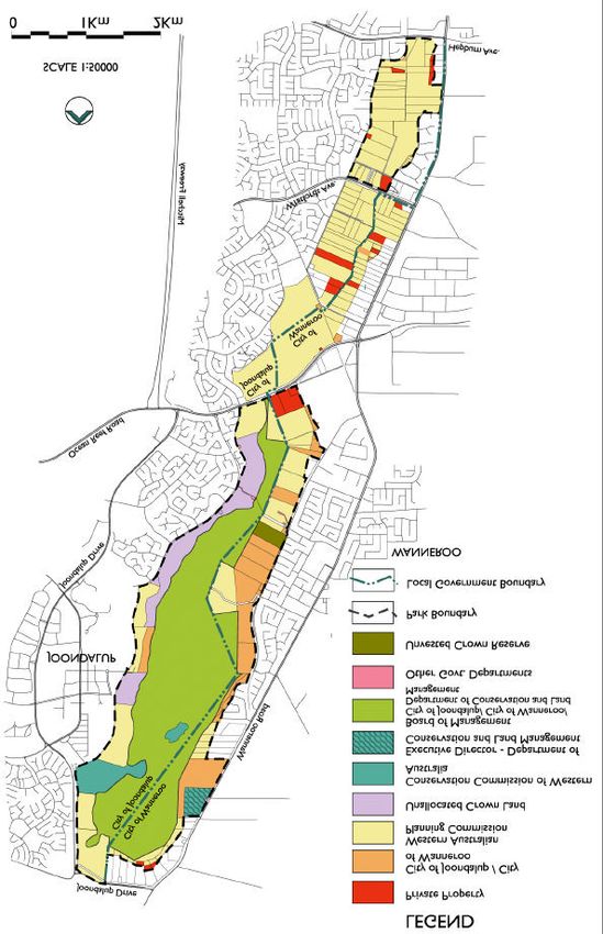
PREFACE

Regional parks are areas of regional open space that are identified by planning procedures as having
outstanding conservation, landscape and recreation values. Regional parks provide the opportunity for a
consortium of management agencies and private landowners to develop co-ordinated planning and
management strategies.

Regional parks were first proposed in the Stephenson - Hepburn Report of 1955, which later formed the basis of
the Perth Metropolitan Region Scheme in 1963. Since then, State planning agencies have been acquiring
suitable private land in anticipation of the time when regional parks would be formally created.

In 1997, the State government announced a commitment to introduce legislation to give regional parks legal
standing and vesting in the former NPNCA, now the Conservation Commission of Western Australia. Eight
regional parks were recognised as formal identities, with the co-ordination of their management progressively
transferred to the Department of Conservation and Land Management. Other regionally significant parklands
exist within the Perth metropolitan region, for example Kings Park, Bold Park and Whiteman Park, these parks
are managed by other government agencies.

This Management Plan is a commitment of the State and local governments to coordinate the management of
Yellagonga Regional Park. The role of the Department of Conservation and Land Management in regional park
management is two-fold. Firstly, it is to manage the areas of regional parks that are vested in the Conservation
Commission of Western Australia. Secondly, it is responsible for coordinating the management of regional
parks. The latter is initiated through the preparation of management plans for the parks.

The Yellagonga Regional Park is important in terms of both the conservation values and the recreational
opportunities it provides within a highly urbanised environment. This Management Plan, which is based on
previously prepared ecological, recreational and historical surveys, seeks to establish a clear vision for how this
important public asset can best be managed and protected.

The Park faces a number of critical management challenges, many of which originate from the surrounding
water catchment area and urban development such as storm water and groundwater pollution. Other
management issues effecting the Park include the invasion of weeds, the occurrence of fire, rubbish dumping,
the presence feral animals and pests, uncontrolled visitor access, poor control of domestic pets, degradation of
heritage sites, fauna habitats and bushland areas as well as the demand for access to the Park by the
community. The elongated boundaries of the Park also create management difficulties in attempting to
minimise the overall impacts of external influences on the Park.

This management plan cannot solve all of the ecological problems affecting the Park, especially those that
emanate from surrounding land uses and are whole of catchment issues. This plan is not a catchment
management plan, however it identifies matters that are directly affecting the Park from within the catchment.
Any planning for the catchment of the wetlands within the Park should complement this management plan.
Presently, integrated catchment management for the wetlands within the Park is being undertaken through the
Yellagonga Catchment Group and the Cities of Joondalup and Wanneroo.

Work by management authorities, which is supported by the local community, is already taking place in the
Park. This management plan aims to protect the Park’s conservation areas and provide a sound basis for
planning to rehabilitate degraded areas, whilst allowing for recreational activities that will not compromise the
natural assets of the Park.

                                                       i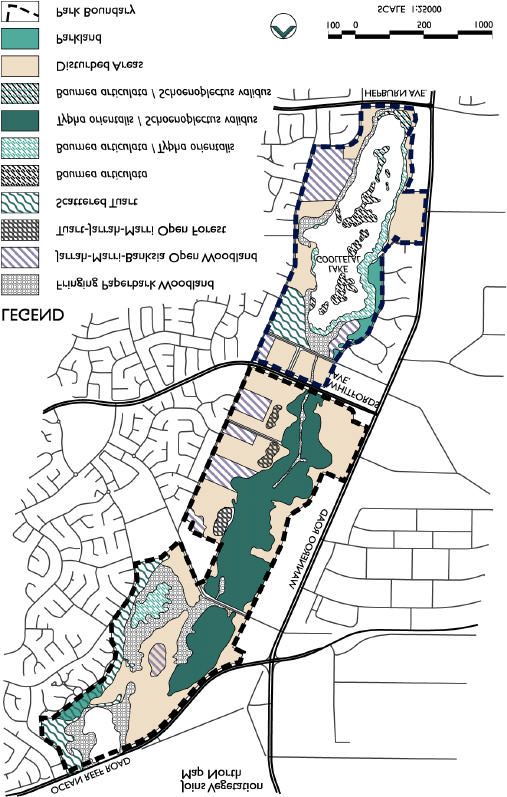
ACKNOWLEDGMENTS

Numerous individuals and groups have contributed valuable ideas and information in the preparation of this Plan
and their efforts are gratefully acknowledged.

In particular, the contributions of the Yellagonga Regional Park Community Advisory Committee are appreciated.
Past and present Committee members who contributed to the preparation of this Plan include Mr Peter McKenzie
(Chair); Mr Laurie Boylan; Dr Mike Bam ford; Dr Hugo Bekle; Mr David Udy; Mr Trevor Moran; Mr David Stalker;
Mr Luke Edwards; Mrs Dot Newton and Mr Bill Evans. The efforts of the consultancy team comprising, David
White, Rod Safstrom, John Wood, John Tuzee, Bill James, and Linda Taman are also acknowledged.

NOMENCLATURE

Inclusion of a name in this publication does not imply its approval by the relevant nomenclature authority.

CITY OF JOONDALUP AND CITY OF WANNEROO

The Cities of Joondalup and Wanneroo have worked closely with Department of Conservation and Land
Management in the preparation of this Management Plan. In partnership with the Department of Conservation
and Land Management, the Cities will use the Plan as a guide in managing the Park and the many issues that
impact upon it.

THE CONSERVATION COMMISSION OF WESTERN AUSTRALIA AND THE DEPARTMENT OF
CONSERVATION AND LAND MANAGEMENT

All national parks, conservation parks, nature reserves, and other conservation reserves in Western Australia are
vested in the Conservation Commission of Western Australia. These reserves are managed on behalf of the
Conservation Commission of Western Australia by the Department of Conservation and Land Management.

As the controlling body, the Conservation Commission of Western Australia is responsible for having
management plans prepared for all lands that are vested in it. A Draft Management Plan for Yellagonga
Regional Park was prepared by the Department of Conservation and Land Management and issued for
public comment in April 2000. Forty-five submissions were received and were considered in the
preparation of this Final Plan prior to its approval by the Conservation Commission of Western Australia
and the Minister for the Environment and Heritage.

                                                                 ii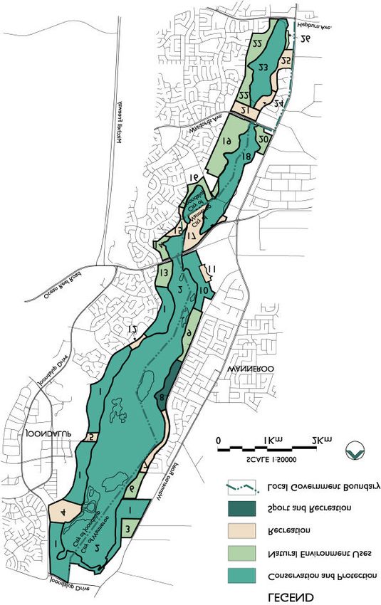
Table of Contents

A.      INTRODUCTION                                                                                                                    1
        1 - Purpose and Status of the Management Plan............................................................ 1
        2 - Regional Parks ........................................................................................................ 1
        3 - Yellagonga Regional Park ........................................................................................ 2
        4 - The Management Plan and Community Involvement .................................................. 4
B.      PRINCIPAL MANAGEMENT DIRECTIONS                                                                                                 6
        5 - The Vision for the Park ............................................................................................. 6
        6 - Management Policies ............................................................................................... 6
        7 - Land Tenure and Park Boundary .............................................................................. 6
        8 - Interim Management and Legislative Amendments .................................................... 8
        9 - Park Management Zones ......................................................................................... 9
        10 - Integrated Management and Planning of the Park and Adjacent Areas .................... 14
        11 - Key Performance Indicators.................................................................................. 15
C.      CONSERVATION                                                                                                                  20
        12 - Principal Conservation Directions .......................................................................... 20
        13 - Geology, Soils and Landform................................................................................ 20
        14 - The Lakes and Wetlands ...................................................................................... 21
        15 - Flora and Vegetation............................................................................................ 23
        16 - Fauna ................................................................................................................. 28
        17 - Weeds ................................................................................................................ 29
        18 - Fire ..................................................................................................................... 32
        19 - Midge and Mosquito Control ................................................................................. 33
        20 - Pets and Introduced Animals ................................................................................ 34
        21 - Rehabilitation ...................................................................................................... 37
        22 - Cultural Heritage.................................................................................................. 38
        23 - Park Aesthetics and Landscape Amenity............................................................... 40
        24 - Greenway Corridors and Links.............................................................................. 43
D.      RECREATION                                                                                                                    45
        25 - Principal Recreation Directions ............................................................................. 45
        26 - Visitor Use........................................................................................................... 45
        27 - Recreation Masterplan ......................................................................................... 46
        28 - Recreation Sites and Facilities .............................................................................. 46
        29 - Park Access and Circulation................................................................................. 48
        30 - Signs .................................................................................................................. 52
        31 - Visitor Safety ....................................................................................................... 52
        32 - Services and Utilities ............................................................................................ 53
E.      COMMERCIAL CONCESSIONS                                                                                                        55
        33 - Principal Commercial Directions ........................................................................... 55
        34 - Leases and Licences ........................................................................................... 55
        35 - Mining and the Extraction of Basic Raw Materials .................................................. 61
F.      RESEARCH AND MONITORING                                                                                                       62
        36 - Principal Research and Monitoring Directions ........................................................ 62
        37 - Research and Monitoring ..................................................................................... 62
G.      COMMUNITY RELATIONS                                                                                                           63
        38 - Principal Community Relations Directions.............................................................. 63
        39 - Interaction with the Community and Other Organisations ........................................ 63
        40 - Information, Interpretation and Education .............................................................. 63
H.      PLAN IMPLEMENTATION.                                                                                                          66
        41 - Priorities, Funding and Staff.................................................................................. 66
        42 - Community Involvement ....................................................................................... 67
        43 - Term of this Plan ................................................................................................. 67
        44 - Performance Assessment..................................................................................... 68

        References and Bibliography....................................................................................... 69
        Abbreviations ............................................................................................................. 73
        Appendix 1: Contacts.................................................................................................. 74

                                                                            iii
Figures

Figure 1   - Regional Park Planning Hierarchy .................................................................................. 2
Figure 2   - Park Location ................................................................................................................ 3
Figure 3   - Existing Land Tenure and Park Boundary ..................................................................... 10
Figure 4   - Management Zones and Areas ..................................................................................... 11
Figure 5   - Water Level Fluctuation ............................................................................................... 22
Figure 6   - Vegetation .................................................................................................................. 27
Figure 7   - Greenway Corridors and Links ..................................................................................... 44
Figure 8   - Recreation Masterplan ................................................................................................. 51

Tables

Table 1 - Management Zones and Land Tenure............................................................................ 12
Table 2 - Performance Assessment ............................................................................................. 17

                                                                              iv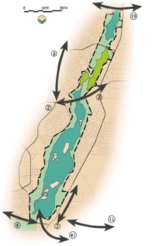
Part A. Introduction

                                     A.         INTRODUCTION

 1 - Purpose and Status of the                                2 - Regional Parks
 Management Plan
                                                             WHAT IS A REGIONAL PARK?
PURPOSE OF THE PLAN
                                                             Regional parks are areas of regional open space
The purpose of this Management Plan (“the Plan”)             that are identified by planning procedures as having
is to provide broad direction for the protection and         regionally significant conservation, landscape and
enhancement of the conservation, recreation and              recreation values. Regional parks are a land
landscape values of Yellagonga Regional Park (“the           management system that provides the opportunity
Park”). It will do this by developing strategies             for a coordinated planning and management
aimed at conserving the special features of the Park         strategy by different land management agencies
as well as anticipating future community                     and private landowners.
requirements. The Plan will help ensure the Park is
managed appropriately and is capable of sustaining           Regional parks may comprise of Crown land vested
its high nature conservation and cultural values as          in State government agencies and local
well as use by the community (refer Section 5 –              governments, as well as private lands where the
Vision for the Park).                                        agreement of the landowner is obtained.

Given the strategic nature of this Plan, more                As such, regional parks could comprise collectively
detailed planning (referred to as subsidiary plans)          of lands with a variety of tenures and reserve
will be required prior to significant works taking           purposes. They could be a package of multi-
place within the Park (Section 41). Examples of              purpose, multi-vested reserves drawn together for
subsidiary plans include a weed management plan              coordinated management by the Department of
(Section 17), a rehabilitation plan (Section 21) and         Conservation and Land Management. Yellagonga
site development plans for specified Park areas              Regional Park for example consists of land
(Section 28).                                                comprising Crown reserves vested in the City of
                                                             Joondalup, City of Wanneroo, and the Conservation
STATUS OF THE PLAN                                           Commission of Western Australia as well as
                                                             freehold land owned by the WAPC and private
This Plan provides statutory direction over all lands        individuals.
and waters of the Park vested in the Conservation
Commission of Western Australia and managed by               Those lands that have been acquired by the WAPC
the Department of Conservation and Land                      for inclusion into the Park are now to be transferred
Management. The Plan will act as an “umbrella”               to the Conservation Commission of Western
document coordinating existing plans for specific            Australia and the respective local governments for
areas of the Park. Implementation of existing area           management as part of the Park.
plans, such as the Lake Goollelal Management
Plan, will need to be consistent with the overall            It is intended that the high level of protection
direction of this Plan. Additionally, future plans for       currently existing for lands already vested in the
areas within the Park will need to be written in a           Conservation Commission of Western Australia
manner that complements the Yellagonga Regional              (such as national parks or nature reserves) will
Park Management Plan.                                        continue as the regional park concept is
                                                             implemented.
The Conservation Commission of Western Australia
endorses this Plan and acknowledges that the                 THE REGIONAL PARK CONCEPT
Department     of   Conservation      and    Land
Management has the responsibility for coordinating           The concept of regional open space was first
the management of the Park. In consultation with             introduced to Western Australia by the Stephenson
the Department of Conservation and Land                      - Hepburn Report in 1955, which recommended that
Management, the Western Australian Planning                  a statutory region plan be prepared for Perth which
Commission (WAPC) will use this Plan to assist               reserved private land required for future public
with the assessment of development proposals on              purposes. In I963, the Perth Metropolitan Region
lands within and adjoining Yellagonga Regional               Scheme (MRS) was established and land was
Park.                                                        reserved for “Parks and Recreation”. This land
                                                             (subject to amendments of the MRS) has been
The Cities of Joondalup and Wanneroo have                    gradually acquired by State planning authorities
worked     closely   with   the   Department    of           with the intention to protect open space of regional
Conservation and Land Management in the                      significance for conservation and recreation.
preparation of this Management Plan. In
partnership with the Department of Conservation              The Environmental Protection Authority’s (EPA)
and Land Management, the Cities will use the Plan            Conservation through Reserves Report for Western
as a guide in managing the Park and the many                 Australia, The Darling System – System 6 (DCE,
issues that impact upon the Park.                            1983), identified areas with regionally significant
                                                             conservation, landscape and recreation value. It
                                                             also recommended areas of land to be managed as
                                                         1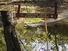
Part A. Introduction

regional parks. A system of regional parks was
envisaged which included the land reserved for                Implementation of local area management plans
“Parks and Recreation” in the MRS which                       such as the Lake Goollelal Management Plan plans
surrounded the Lakes of Joondalup and Goollelal               will need to be consistent with the overall direction
(System Six Recommendation M7).                               of this Plan.

In 1989, the State government decided that the                The preparation and implementation of subsidiary
responsibility for regional park management would             plans are listed as specific strategies within the
be established within the Department of                       relevant sections of this plan.
Conservation and Land Management and that the
responsibility for planning the acquisition of lands          Action plans, operational plans and annual works
for regional open space be retained by the                    programmes will be prepared to guide maintenance
Department for Planning and Infrastructure (DPI) on           and operational works within the Park.
behalf of the WAPC.
                                                              The community is encouraged to become involved
A task force report (1990) was prepared by the                in aspects of planning for the Park by joining the
former Department of Planning and Urban                       Yellagonga Regional Park Community Advisory
Development (DPUD) and the Department of                      Committee or by contacting the managing agencies
Conservation and Land Management outlining                    listed in Appendix 1.
proposed     administration,   planning    and
management of regional open space.                             3 - Yellagonga Regional Park
The EPA’s Red Book: Status Report (1993)                      In 1975, most of the lands that now comprise
describes the transformation of regional parks from           Yellagonga Regional Park were reserved as “Parks
concept to reality as being difficult because of the          and Recreation” in the MRS. Since that time most
range of land tenure involved and the funding                 of the private lands within the Park have been
requirements for continual management of the                  acquired by State planning authorities through the
parks.                                                        Metropolitan Region Improvement Fund Tax, or
                                                              ceded free of cost to the Crown as a condition of
In June 1997, the State government announced a                subdivision.
commitment to introduce legislation to give regional
parks legal standing and vesting in the National              The Park was named Yellagonga Regional Park in
Parks and Nature Conservation Authority (now the              1990 to honour Yellagonga, the leader of the Mooro
Conservation Commission of Western Australia).                people who inhabited the region north of the Swan
The coordination of management of eight                       River at the time of European settlement.
metropolitan regional parks would be progressively
transferred to the Department of Conservation and             The Yellagonga Regional Park Planning Review
Land Management.                                              (DPUD, 1992a) identified the area of land to be
                                                              included in the Regional Park and recommended
REGIONAL PARK PLANNING                                        steps for its establishment and administration. The
                                                              Planning      Review    report    suggested    minor
Planning for regional parks occurs at a number of             amendments to the MRS relating to the Park’s
levels. Regional park management plans are a part             boundaries,      land    acquisition   and    tenure
of a broad suite of planning undertaken by the                arrangements as well as recommending that a
relevant managing agencies. Figure 1 illustrates              Community Advisory Committee be formed to
the planning levels typically undertaken for regional         provide advice during the establishment phase.
parks.
                                                              The Planning Review report also proposed that a
                                                              management plan for Yellagonga Regional Park be
                                                              prepared by the Department of Conservation and
                                                              Land Management in conjunction with relevant local
                     Legislation                              governments and the Conservation Commission of
                                                              Western Australia.
                  Agency policies,
                       and
              corporate / business plans                      OVERVIEW

            Regional park management                          Yellagonga Regional Park is currently one of eight
                      plans                                   regional parks within the Perth metropolitan region.
                                                              It is located approximately 20km north of Perth City
             Local area management plans                      and 6km from the Indian Ocean.                 It is
         eg Lake Goollelal Management Plan                    approximately 13km long and varies in width from 1
                                                              to 1.5km. The Park comprises 1400 hectares and
        Subsidiary plans eg fire response plan,               is primarily focussed on a wetland system that
   weed management plan, site development plans etc.          includes      Lake    Joondalup,   Beenyup       and
                                                              Walluburnup Swamps, Lake Goollelal and the
    Operational / action plans, annual works programmes       surrounding lands reserved in the MRS for “Parks
                                                              and Recreation”. It is of regional importance
                                                              because of its natural, cultural and recreational
Source: ANZECC 2000.                                          resources in a rapidly growing suburban area.
                                                              Additionally the Park provides an important
Figure 1 - Regional Park Planning Hierarchy                   (north/south) link with Neerabup National Park and

                                                          2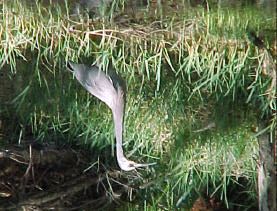
Part A. Introduction

Yanchep National Park. Figure 2 shows the location        also attract visitors from a broad area within
of the Park.                                              metropolitan Perth.

The lakes and wetlands are the dominant                   The pressures on the Park and challenges to the
landscape features of the Park. These lakes and           managing agencies will continue to grow over time.
wetlands are surface expressions of groundwater,          It will be the role of the Park managers with support
which emerges in interdunal swales within the             from the community to implement this Plan to
Spearwood Dune System as a chain of linear lakes          effectively manage and counter those pressures.
and wetlands. This chain of lakes begins 21
kilometres to the north at Loch McNess in Yanchep         PARK VALUES
and extend south to Lake Goollelal.           Lake
Joondalup, the largest of the water bodies, lies in       Natural Environment Value
the northern half of the Park. Walluburnup and            Yellagonga Regional Park contains a wide variety
Beenyup Swamps are located centrally within the           of ecosystems from upland forest, fringing wetland
Park, and Lake Goollelal is situated in the               and aquatic vegetation to open water bodies. This
southernmost part of the Park.                            rich diversity and complexity of ecosystems has
                                                          very high conservation value within a rapidly
                                                          expanding urban setting. The wetlands within the
                                                          Park are some of the last remaining freshwater
                                                          wetland systems on the Swan Coastal Plain.

                                                          The vegetation communities found within the Park
                                                          are significant as they are representative of
                                                          communities once widespread on the Swan Coastal
                                                          Plain but now significantly cleared. The vegetation
                                                          on the upland areas surrounding the wetlands was
                                                          once Jarrah - Marri - Banksia (Eucalyptus
                                                          marginata - Corymbia calophylla - Banksia
                                                          attenuata) Open Forest, and Tuart-Jarrah - Marri
                                                          (Eucalyptus    gomphocephala        -   Eucalyptus.
                                                          marginata - Corymbia calophylla) Open Forest.

                                                          The wetlands of the Park serve as important
                                                          breeding grounds for local birds and as a summer
                                                          refuge for a diverse bird population, some of which
                                                          are trans -equatorial migratory wading birds. The
                                                          diversity of wetland and upland habitats comprising
                                                          Fringing     Paperbark     Woodland      (Melaleuca
                                                          rhaphiophylla) and Flooded Gum Woodland
                                                          (Eucalyptus rudis) provide habitat for a variety of
                                                          waterbirds and bushbirds.

                                                          Lake Joondalup is considered of national
                                                          significance and is listed on the Register of the
                                                          National Estate.

                                                          Cultural Heritage Value
                                                          Yellagonga Regional Park has cultural and
                                                          historical significance to both Aboriginal and non-
Figure 2 - Park Location
                                                          Aboriginal people.        There are seven listed
                                                          Aboriginal sites within the Park known to the
A wide range of recreational opportunities and
                                                          Department of Indigenous Affairs (DIA) and another
facilities are available to Park visitors. Natural
                                                          four sites adjoining the Park. In addition, there are
features such as Lake Joondalup and Lake
                                                          other possible sites, which are yet to be listed by
Goollelal along with parkland settings at Neil
                                                          the DIA.
Hawkins Park attract many people to the Park. The
open space and water bodies provide significant
                                                          Land comprising Yellagonga Regional Park is
conservation and amenity values within the rapidly
                                                          significant to the local Aboriginal people (Nyungars)
developing surroundings. The lakes and wetlands
                                                          because it was an important camping area used
also provide research and educational opportunities
                                                          widely for watering, food-gathering, camping and
for better understanding urban lakes and wetlands,
                                                          tool-making, hunting and corroborees, and summer
their ecosystems and groundwater interaction.
                                                          social life (Brittain, 1990).
Yellagonga Regional Park adjoins the City Centre
                                                          In the Aboriginal seasonal cycle of camp
of Joondalup, the regional focus of Perth’s North
                                                          movements, it was used as an east-west staging
West Corridor. In 1996 the population of the former
                                                          between the foothills and the ocean, and a north-
City of Wanneroo (now the City of Joondalup and
                                                          south staging between Mt. Eliza and the Moore
the City of Wanneroo) was 213,368. The rapid
                                                          River. The lands of Yellagonga Regional Park
growth in the City of Joondalup and the City of
                                                          comprised a significant camp due to its centrality
Wanneroo is expected to continue, with the
                                                          within the Mooro district, its proximity to the ocean
population anticipated to grow to over 415,000 by
                                                          and other lakes and the abundance of food
2021 (DPUD, 1992). The Park’s regional focus will
                                                      3
Part A. Introduction

including wildfowl, kangaroos and other marsupials             heritage and historical background. Two heritage
(Brittain 1990).                                               trails are located within the Park.         The Lake
                                                               Joondalup Trail is a 27km self-guided walk/drive
According to Mr Ken Colbung, Yellagonga Regional               trail, which traces the development of Wanneroo
Park is important to the present Nyungar people                around Lake Joondalup. The Yaberoo – Budjara
forming part of their Dreaming (DPUD 1992a).                   Heritage Trail is a 28km walk trail which links Lake
                                                               Joondalup and Yanchep National Park and
The Park also contains historical remnants of early            highlights features of local Aboriginal and non-
European settlement. Brittain (1990) notes 100                 Aboriginal cultural significance in the area.
items, people, places or events that are of
significance within and surrounding Yellagonga                 Perry’s Paddock is the site for Wanneroo’s Annual
Regional Park.                                                 Picnic Day and provides a venue for other large-
                                                               scale outdoor events. The annual picnic is an
Landscape Value                                                important social day for the people of Wanneroo.
Yellagonga Regional Park provides significant
landscape and amenity value to the region. The                 Cockman House also offers recreational value for
Park’s    landscape     provides    strong    visual           those interested in local history and its relationship
connections both within and into surrounding areas.            to the Park. It provides an example of a typical
Significant views of the major water features                  limestone cottage of the early settlers to the area.
including the lake landscapes of Joondalup and
Goollelal can be appreciated from many vantage                 Commercial Value
points around the Park. These views are an                     There are opportunities for the establishment of
important part of the Park’s identity.          The            commercial operations within Yellagonga Regional
relationship of adjoining land uses to the Park’s              Park. These could range from hire facilities at
landscape can have a significant impact on the                 activity nodes around the Park, to a kiosk or
overall amenity of the Park.                                   restaurant, to education facilities providing
                                                               interpretation and information about the natural
Many landscape character types contribute to the               environment and cultural values of the Park. Such
overall high visual quality of the Park ranging from           facilities should complement the values of the Park
mature woodland areas to extensive views of open               and so engage Park visitors to interact in new ways
water (along with its wildlife) to well maintained             – without compromising or degrading the qualities
areas of grassed parkland.                                     of the environment. Operations that reinforce the
                                                               natural or cultural values of the Park will be the
Recreational Value                                             most appropriate and valuable enterprises.
Yellagonga Regional Park is of high recreational
value as it provides opportunities for a wide range            Research Value
of passive and active recreation.                              Yellagonga Regional Park has significant research
                                                               and scientific values. On one hand, it contains rich,
Of particular significance is the opportunity to               dynamic ecosystems with seasonal and periodic
recreate in natural environments that are relatively           variations, subject to considerable external
undisturbed yet close to urban areas. A wide                   pressures and inputs. On the other hand it has
variety of natural features such as the lakes,                 areas with high recreational demand requiring an
wetlands and bushland areas, provide visitors with             understanding of changing social use of natural
a multitude of experiences and recreational                    areas for recreation and landscape design.
opportunities. It is these features in a natural park
setting that attract people to the Park.
                                                               In particular, the extraction of technical data on
                                                               wetland ecosystems and water quality makes the
There are many recreational opportunities available
                                                               Park an extremely valuable resource in gaining
to Park visitors including picnicking, bushwalking,            technical and managerial expertise that can be
bird watching and general nature observation.
                                                               applied to other wetlands across the Swan Coastal
Additionally, recreation pursuits such as bicycle
                                                               Plain.
riding will be catered for in the future.

Yellagonga Regional Park contains a number of                  4 - The Management Plan and Community
smaller recreation nodes catering for informal                 Involvement
recreation. They offer a variety of settings, facilities
and recreation opportunities. Neil Hawkins Park,               This Management Plan has been prepared in five
which is the main recreation node of the Park,                 phases:
caters for family picnics, large group activities and
summertime outdoor concerts and performances.                  1.   The first phase was aimed at identifying the
Picnic Cove Park and Banyandah Park are less                        relevant planning and management issues.
developed, providing opportunities for small groups                 This was achieved by undertaking a literature
and informal recreational activities.                               review, analysing the existing condition of the
                                                                    Park and organising a community workshop.
The eastern bank of Lake Joondalup caters for                       Public involvement in this phase was
active sporting activities at Joondalup Park and                    encouraged through newspaper articles and
Scenic Drive Park. Indoor sporting and community                    canvassing key stakeholders for the community
activities occur at Wanneroo Indoor Community                       workshop.
Recreation Centre.
                                                               2.   The second phase was the preparation of the
Yellagonga    Regional   Park  also    presents                     Draft Management Plan.      This involved
recreational value in terms of its rich cultural                    identifying values and preparing planning
                                                           4
Part A. Introduction
strategies to protect those values and address
the issues identified in phase one. Within this
phase the Department of Conservation and
Land Management, the Department for
Planning and Infrastructure, the City of
Joondalup and the City of Wanneroo provided
advice on the development of the Plan.
3. The third phase involved presentation of the
draft Plan for public comment. Its availability
for review was widely advertised, the draft was
open for public comment for a three month
period.
4. Phase four involved the acknowledgement and
analysis of public submissions.
5. The fifth phase involved the preparation of the
Final Plan incorporating issues or comments
raised within submissions. The revised Plan
was submitted for adoption by the
Conservation Commission of Western Australia
and for approval by the Minister for the
Environment and Heritage.
5Part B Principal Management Directions
B. PRINCIPAL MANAGEMENT DIRECTIONS
5 - The Vision for the Park
6 - Management Policies
The long-term vision for the Park is that:
The objective is to integrate the policies of the
“Yellagonga Regional Park will be a quality management agencies to complement and support
wetland system supported by healthy forest, the vision for the Park.
woodland and parklands with sustainable
community use that recognises Aboriginal and Conservation Commission of Western Australia
non-Aboriginal heritage in a visually and Department Of Conservation and Land
harmonious environment.” Management Policies
GOALS This Plan is based on current policies prepared by
the Conservation Commission of Western Australia
Goals have been set for each major part of the and the Department of Conservation and Land
Plan, while objectives designed to achieve these Management. These policies derive from
goals have also been identified. The following legislation, principally the Conservation and Land
management goals are proposed for the Park. Management Act 1984 and the Wildlife
Conservation Act 1950, and associated regulations.
Conservation Policies are published and distributed throughout
Protect, conserve and enhance the Park’s biota and the Department as policy statements. They are
natural ecosystems as well as its physical, cultural available to the public on request. These policies,
and landscape resources. as they relate to this Park, cover aspects such as
conservation, recreation and community
Recreation involvement.
Provide for and manage recreation, tourism and
leisure in a manner that minimises conflict between Local Government
visitors, and is consistent with other management The management actions of the City of Joondalup
objectives and Park values. and City of Wanneroo should reflect the intent of
this Plan. The local governments involved with the
Commercial Park will adopt the principles outlined in this Plan as
Allow for appropriate commercial uses within the policy for managing their reserves within the Park.
Park and manage them in a manner that minimises
impact on other values and contributes to regional Strategies
park management costs.
1. Apply Department of Conservation and
Land Management and Conservation
Research and Monitoring
Seek a better understanding of the natural, cultural Commission of Western Australia policies
and social environments, and the impacts of visitor in the management of the Park. (Department
of Conservation and Land Management)
use and Park management.
[Ongoing]
Community Relations 2. Prepare a local government policy
Promote informed appreciation of the Park’s natural statement for the management of the Park
environment, cultural values and recreation that reflects the principles outlined in this
opportunities and facilitate liaison with the Plan. (CJ, CW) [High]
community about its management.
Integration of Management
7 - Land Tenure and Park Boundary
Develop and maintain integrated and coordinated
management arrangements between the
participating Park managers and planning The objective is to ensure that the values of the
Park are protected by security of a tenure and
authorities.
reserve purpose.
Strategy
1. Manage the Park for conservation and PARK BOUNDARY
environmental enhancement and allow
The Yellagonga Regional Park boundary has been
recreation and other uses of the Park to
occur to the extent that they do not impair determined by the Department for Planning and
Infrastructure (DPI) and is based on the boundary
the values of the Park. (Department of
Conservation and Land Management, advocated by the State Planning Commission (now
CJ,CW) [High] the WAPC) in 1992.
The existing Park boundary and land tenure at the
date of this Plan is shown on Figure 3. The
boundary reflects the existing Metropolitan Regional
6Part B Principal Management Directions
Scheme (MRS) under which the entire Park is will be classified as class A under the Land
reserved as “Parks and Recreation”. Administration Act 1997 (refer to Table 1).
LAND TENURE As agreed to by the Cities of Joondalup and
Wanneroo, reserves created from WAPC freehold
Land within the Park consists of reserves and vested in the local governments will be
administered under the Land Administration Act reserved for the purpose of “Public Recreation” and
1997 and vested or managed by State government afforded similar tenure arrangements as the
agencies and/or the Cities of Joondalup and reserves vested in the Conservation Commission of
Wanneroo, as well as unallocated Crown land and Western Australia.
freehold land owned by government agencies and
private individuals. Crown reserves and unallocated Crown land
Crown reserves now vested in the Cities of
This Plan seeks to determine the most appropriate Joondalup or Wanneroo which are proposed to be
tenure arrangements for the land comprising the vested in the Conservation Commission of Western
Park. The Plan seeks to reserve land and vest it in Australia will be converted to Class A Reserves
either: under the Land Administration Act 1997 and
afforded an appropriate purpose.
§ the Conservation Commission of Western
Australia; Existing Crown land reserved for utilities or services
§ the City of Joondalup; such as drainage will retain their existing reserve
§ the City of Wanneroo; or purpose and tenure arrangements.
§ the National Trust of Australia (WA)
The closure of road reserves considered
Crown reserves will be created using the unnecessary by planning and management
management areas outlined in the Plan’s Park agencies will be further investigated. Should road
Management Zones as a guide (Section 9). New reserves be closed they will be included in the Park
reserves created in the Park may have and afforded an appropriate reserve purpose and
management orders under the Land Administration tenure arrangements consistent with the protection
Act 1997 requiring the relevant vested authority to and enhancement of Park values (refer to Table 1).
comply with this Plan.
Unallocated Crown land is to be created as
Reserves to be created and vested in the local reserves and transferred to either the Conservation
governments comprise Areas 6, 9, 11 (City of Commission of Western Australia or the relevant
Wanneroo) and 15 (City of Joondalup). The WAPC local government. These reserves will also be
has agreed to a three-year lease to the National afforded an appropriate reserve purpose and tenure
Trust of Australia (WA) for the conservation and arrangements consistent with the protection and
interpretation of the State heritage- lis ted Luisini enhancement of Park values.
Winery. As part of this agreement, the National
Trust of Australia (WA) will accept vesting of the Reserve 31048 – Lake Joondalup
lands comprising the winery when the lease Reserve Number 31048 (Lake Joondalup) is
expires. Additionally, as part of this management currently jointly managed by the City of Joondalup,
planning process, the National Trust of Australia City of Wanneroo and the Department of
(WA) has agreed to accept the vesting of Area 24 in Conservation and Land Management. This
its entirety. As such Area 24 will be created as a management arrangement has been in place since
reserve and vested in the National Trust of Australia October 1971 when the then Western Australian
(WA) (see Figure 4). Wildlife Authority and the then Shire of Wanneroo
agreed to manage the reserve as a board.
The tenure arrangements for some areas of the
Park will not change, for ins tance, Lot 1 Joondalup The reserve is to be vested solely with the
Drive is to remain vested in the Conservation Conservation Commission of Western Australia and
Commission of Western Australia as a conservation managed by the Department of Conservation and
park. Land Management. The reserve will cover the
water body of Lake Joondalup. The wetland
Should additional land be included within the vegetation around the perimeter of the Lake will be
boundary of the Park during the term of this Plan, included in separate reserves and managed in
its tenure arrangements will be consistent with the accordance with Table 1 and Figure 4.
protection and enhancement of the Park’s values.
The vesting of Res erve Number 31048 solely with
Transfer of WAPC-owned freehold land the Conservation Commission of Western Australia
Freehold lands owned by the WAPC will be will not affect the existing arrangements for the
converted into reserves under the Land implementation of The Midge Management Strategy
Administration Act 1997 and vested in the for Lake Joondalup (2001) (Section 19). Midge
Conservation Commission of Western Australia or management will continue to be the responsibility of
the relevant local government and managed in the City of Joondalup, City of Wanneroo and the
accordance with this Plan. Department of Conservation and Land
Management given the issue emanates from the
Reserves created from WAPC freehold land and surrounding water catchment areas and requires
vested in the Conservation Commission of Western the expertise and resources of the three agencies
Australia will be afforded an appropriate purpose for to be integrated.
the protection and enhancement of Park values and
7Part B Principal Management Directions
Private property
This Plan is not the mechanism by which freehold 8 - Interim Management and Legislative
land, held by private individuals or organisations, is Amendments
to be acquired by the WAPC. The Department for
Planning and Infrastructure on behalf of the WAPC The objectives are to provide for the protection of
will continue its voluntary land acquisition the Park under the Conservation and Land
programme within regional parks. Additionally, the Management Act 1984 and to ensure that interim
WAPC may require land to be ceded free of cost to management arrangements facilitate the
the Crown as a condition of subdivision. appropriate management of the Park.
Until acquired by the WAPC these lands will remain INTERIM MANAGEMENT ARRANGEMENTS
protected under Perth’s Metropolitan Region
Scheme by their “Parks and Recreation” Prior to the gazettal of the Final Plan and
reservation. subsequent transfer of lands to the appropriate
managing agencies, there is a need to clearly
This Plan will not dictate the management of define interim management arrangements between
privately owned freehold land held by individuals or the land managing agencies involved in the Park.
organisations in the Park. However, when the land
is acquired by the WAPC, management will be in The Department of Conservation and Land
accordance with the Plan’s Park Management Management will coordinate the interim
Zones (Section 9). management of the Park by management
agreements prepared for Crown reserves and
Access by Park visitors to areas of private property freehold lands controlled by State and/or local
owned by individuals or organisations in the Park is government agencies involved in the Park.
not available until it is acquired by the WAPC.
Negotiated settlements are required in order to A regional park management agreement for interim
obtain the remainder of private land within the Park Park management may comprise either:
boundary. In relation to Lot 102 Goollelal Drive,
Kingsley, acquisition by the WAPC is subject to the § a Section 16 Agreement of the Conservation
restrictions imposed by the Deed of Compromise and Land Management Act 1984;
covering this property. § a Memorandum of Understanding;
Strategies Interim management of WAPC owned land
Section 16 of the Conservation and Land
1. Adopt the Park boundary as shown on Management Act 1984 allows the Department of
Figure 3. (Department of Conservation and Conservation and Land Management to enter into
Land Management, CJ, CW, DPI) [High] agreements for the management of private
2. Create reserves to be vested in the relevant (freehold) land.
managing agency in accordance with the
Management Zones outlined in Table 1 and Following June 1997, when the management
Figure 4. (DOLA, WAPC, DPI, Conservation responsibility for regional parks was progressively
Commission of Western Australia, transferred to the Department of Conservation and
Department of Conservation and Land Land Management, the WAPC and the Department
Management, CJ, CW) [Medium] of Conservation and Land Management agreed to
enter into a Section 16 agreement under the
3. Consider management orders for new Conservation and Land Management Act 1984.
reserves to be vested with the relevant local This formal agreement has been finalised and acts
governments requiring compliance with this as an interim management arrangement prior to the
Plan. (DOLA) [Medium] land being vested in the Conservation Commission
of Western Australia or the relevant local
4. Seek to acquire the remainder of the private
governments.
land within the Park as soon as practicable
from willing landowners. (WAPC) [High]
The agreement includes all WAPC lands within
5. Investigate the closure of road reserves regional parks with the exception of those leased to
within the Park that are considered local governments or private individuals or
unnecessary by planning and management organisations.
agencies. (Department of Conservation and
Land Management, DPI, CJ, CW) [Medium] On lands owned by the WAPC, the Department of
Conservation and Land Management can utilise the
WAPC (Reserved Land) regulations administered
by the Department for Planning and Infrastructure.
Interim management of Crown land and freehold
land controlled by government agencies
Local governments and State government agencies
will be responsible for managing lands under their
control. An overall integrated approach to the
interim management of Yellagonga Regional Park
will be coordinated by the Department of
Conservation and Land Management.
8Part B Principal Management Directions
Interim management arrangements for private Within Yellagonga Regional Park four management
property zones have been identified:
Where individuals or organisations hold private
property within the Park, the owner is responsible a) Conservation and Protection
for its management. The Department of b) Natural Environment Uses
Conservation and Land Management may seek c) Recreation
formal management arrangements with individual d) Sport and Recreation
private landowners within the Park. In relation to Lot
102 Goollelal Drive, Kingsley, should an agreement Refer to Table 1 for the management emphasis and
be sought, it would need to be done so in the acceptable uses and facilities within each zone.
context of earlier agreements between the WAPC
and the owner. The zoning scheme does not direct the
management of privately owned freehold land held
LEGISLATIVE AMENDMENTS by individuals or organisations in the Park.
However, when the land is acquired by the WAPC,
The Conservation and Land Management Act 1984 management will be in accordance with the Plan’s
will need to be altered to specifically include the Park Management Zones.
management of regional parks. The management of
regional parks may be included as a function of the Strategy
Department of Conservation and Land
1. Base future management of the Park on the
Management in the Act.
zoning plan (Figure 4). (Department of
Strategies Conservation and Land Management, CJ,
CW) [Ongoing]
1. Implement the management agreement
under Section 16 of the Conservation and
Land Management Act 1984 with the WAPC.
(Department of Conservation and Land
Management, WAPC, Conservation
Commission of Western Australia) [High]
2. Prepare interagency management
agreements for interim park management
for areas controlled by State or local
government as required. (Department of
Conservation and Land Management,
Conservation Commission of Western
Australia, CJ, CW) [High]
3. Amend the Conservation and Land
Management Act 1984 to provide for
regional parks. (Department of
Conservation and Land Management)
[Medium]
9 - Park Management Zones
The objective is to adopt a management zoning
system that protects conservation values, provides
for appropriate recreation and other uses, and
provides for efficient management of the Park.
Management zones are a framework for protecting
the Park by minimising existing and potential
conflicts between uses and activities. They provide
a guide to the public uses and management
activities which are appropriate in certain areas and
indicate which management objectives have priority
in any area.
The management zones and areas for the Park are
illustrated in Figure 4. They provide a guide for the
future vesting of Park areas. However, given there
are numerous service and utility reserves in the
Park, they should not be used as a detailed
schedule for changing land tenure arrangements in
the Park.
9Part B Principal Management Directions
Figure 3 - Existing Land Tenure and Park Boundary
10Part B Principal Management Directions
Figure 4 - Management Zones and Areas
11Part B Principal Management Directions
Table 1 - Management Zones and Land Tenure
Management Plan Management Reserve Purpose Management Emphasis Acceptable Uses and Facilities
Zone Area Agency
Conservation Area 1 CALM Conservation Park The management emphasis of this zone is to protect Wetlands or Waterbodies:
and and where possible, enhance the conservation values Restricted public access. Unauthorised watercraft and
Protection and landscape qualities of the Park. Priority will be vehicles prohibited. Development of facilities, boardwalks
Area 2 CALM Nature Reserve - given to maintaining the natural state of Conservation and observation platforms are acceptable in certain locations
Conservation of and Protection Areas with a minimum of impairment. (see Figure 8 -Recreation Masterplan). Protection and
Flora and Fauna Visible evidence of management will be minimal. enhancement of natural habitats to ensure survival of
wetland ecosystems is considered essential. Education and
Area 10 CALM Conservation Park research uses allowed.
Area 18 CALM Conservation Park
Area 23 CALM Nature Reserve - Upland Areas:
Conservation of Public access restricted predominately to nature trails, cycle
Flora and Fauna tracks and through access ways (in certain locations).
Development of facilities such as observation platforms are
acceptable in limited locations (see Figure 8 - Recreation
Masterplan). Rehabilitation of vegetation. Habitat protection
for bird species and other fauna is considered essential.
Education and research uses allowed.
Natural Area 3 CALM Conservation Park The management emphasis is to provide for Areas are readily accessible by walking trails and cycle
Environment Area 6 City of Wanneroo Public Recreation appropriate uses of the natural environment. Areas paths. Some development of facilities necessary. These
Uses Area 9 City of Wanneroo Public Recreation will be managed jointly for public use, conservation may include education nodes and facilities (such as car
Area 13 CALM Conservation Park and enhancement of flora and fauna, and parks) associated with visitor nodes. Commercial
Area 14 CALM Conservation Park improvement of landscape qualities. Public use must concessions compatible with the values of the area may be
Area 16 CALM Conservation Park be compatible with the assigned purpose of the considered appropriate within this management zone. The
Area 17 CALM Conservation Park relevant reserve. Visible evidence of management provision of facilities will depend on the values of the area
Area 19 CALM Conservation Park may be moderate to high. Management will and the community demand for facilities. Rehabilitation and
Area 20 CALM Conservation Park encourage uses and develop facilities that promote habitat protection will be necessary.
Area 22 CALM Conservation Park conservation and education.
Area 26 CALM Conservation Park
Recreation Area 4 CALM Conservation Park The prime emphasis of management will be to Public use may be high in these areas. Predominantly
Area 5 City of Joondalup Recreation provide a variety of recreation opportunities. The type passive recreation pursuits, allowing for park and picnic
Area 7 City of Wanneroo Public Recreation and intensity of facility provision will depend on the facility development. Commercial concessions for visitor
Area 11 City of Wanneroo Public Recreation values of any given area, community demand for services may be considered appropriate within this
Area 12 City of Joondalup Recreation recreation and the appropriate management of the management zone. Weed control, rehabilitation, landscaping
Area 15 City of Joondalup Public Recreation Park. Management involves minimising the impact of and reticulation of areas may be necessary.
Area 21 CALM Conservation Park visitor activities through the sensitive placement and
Area 24 National Trust Heritage provision of access and facilities. Weed control and
Area 25 CALM Purposes rehabilitation may be necessary. Visible evidence of
Conservation Park management is likely to be high.
Continued over
page…
12Part B Principal Management Directions
Management Plan Management Reserve Purpose Management Emphasis Acceptable Uses and Facilities
Zone Area Agency
Sport and Area 8 City of Wanneroo Public Recreation Sport and Recreation allows for areas to be used for High use areas developed for active recreation pursuits.
Recreation indoor and outdoor sporting activities. Given these May include sporting ovals, car parking, buildings and
areas are of high use, management will endeavour to reticulated and landscaped areas. Commercial concessions
minimise incompatibilities with surrounding Park for visitor services may be considered appropriate within this
areas. Management involves minimising the impact of management zone. Weed control, rehabilitation, landscaping
visitor activities through the sensitive placement and and reticulation of areas may be necessary
provision of access and facilities. Weed control and
rehabilitation may be necessary in certain locations.
Visible evidence of management is likely to be high.
13Part B Principal Management Directions
10 - Integrated Management and Planning
of the Park and Adjacent Areas
The objective is to provide for the effective
involvement of both the managing agencies and the
community in the management of the Park.
THE PARK MANAGEMENT STRUCTURE
The joint managers of the Park are the Department
of Conservation and Land Management, the City of
Joondalup and the City of Wanneroo, and their
areas of responsibility are set out in the previous
section on Management Zones. It is proposed that
once the final Plan is gazetted, management will be
in accordance with the strategies outlined in this
Plan.
The State government considers the Department of
Conservation and Land Management the most
appropriate agency to provide a strong integrated
framework for the management of complex
conservation and recreation areas. The
Department of Conservation and Land
Management is responsible for managing areas of
the Park vested in the Conservation Commission of
Western Australia and for the overall coordination of
the Park’s management. The Cities of Joondalup
and Wanneroo will manage areas of the Park to be
vested in them in accordance with the strategies
outlined in this Plan.
Cooperation is required by the Park’s managers
and the community for this Plan to be implemented
efficiently and effectively. Close liaison with the
Cities of Wanneroo and Joondalup will occur
regarding the management of the Park, with the
Department of Conservation and Land
Management meeting with the local governments
on a formal basis as required. Strategic decisions
will involve input and negotiation between the land
management agencies. Joint working parties,
comprising representatives from the Department of
Conservation and Land Management, the local
governments and relevant State government
agencies, will be established to facilitate the
preparation of detailed implementation plans for the
Park. The different levels of planning are illus trated
in Figure 1.
In relation to the management of wetland vegetation
at Lake Joondalup, the City of Wanneroo and City
of Joondalup will be responsible for the fringing
wetland vegetation immediately adjacent to the
upland areas under their control, and not for the
wetland vegetation that extends into the water body
of Lake Joondalup (see Figure 4).
A common management direction
The establishment of a management structure,
common goals and agreement on priorities are
necessary for safeguarding this regional resource
where a number of land owners, the general public
and interest groups are involved. This Plan has
been written in conjunction with the proposed land
managers, and comments were sought from the
public on the draft in order to establish a common
management direction. Community involvement
and community education are important
components in achieving the management goals
set out in this Plan.
14You can also read