Montgomery, Vermont Town Plan 2016-2021 - Big Jay from North Hill Road, Winter 2015 - Vermont.gov
←
→
Page content transcription
If your browser does not render page correctly, please read the page content below

Montgomery, Vermont
          Town Plan 2016-2021

          Big Jay from North Hill Road, Winter 2015

Adopted by the Montgomery Selectboard on February 15, 2016
Montgomery Town Plan

                               Prepared by the
                        Montgomery Planning Commission

                       With the assistance of and mapping services by the
                          Northwest Regional Planning Commission
                           75 Fairfield Street, St. Albans, VT 05478
                                         (802) 524-5958

This Municipal Plan update was funded by the State of Vermont Municipal Planning Grant Program.

                     Original document adopted May 1974
                      Amended and updated March 1987
                     Amended and updated November 1994
                     Amended and updated September 2000
                     Amended and updated September 2005
                      Amended and updated August 2010
                     Amended and updated February 2016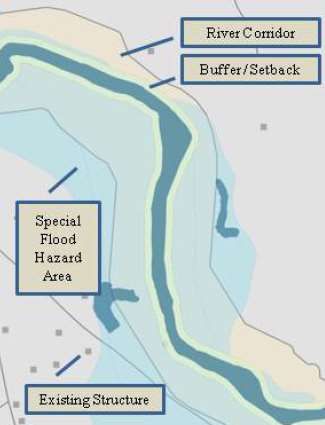
Table of Contents

CHAPTER 1. Introduction ........................................................................................1
CHAPTER 2. Visions for the Future of Montgomery ..............................................3
CHAPTER 3. Summary of Goals and Policies .........................................................4
CHAPTER 4. Community Profile .......................................................................... 11
CHAPTER 5. Archaeological, Historic, and Scenic Resources ............................ 18
CHAPTER 6. Community Facilities ...................................................................... 21
CHAPTER 7. Community Services ........................................................................ 25
CHAPTER 8. Community Utilities ........................................................................ 29
CHAPTER 9. Economy .......................................................................................... 32
CHAPTER 10. Energy ............................................................................................ 38
CHAPTER 11. Transportation................................................................................ 41
CHAPTER 12. Education ....................................................................................... 46
CHAPTER 13. Housing .......................................................................................... 48
CHAPTER 14. Natural Resources .......................................................................... 53
CHAPTER 15. Flood Resiliency ............................................................................ 61
CHAPTER 16. Land Use ........................................................................................ 66
CHAPTER 17. Volunteer Community Groups ...................................................... 70
CHAPTER 18. Compatibility with Neighboring Towns ....................................... 74
CHAPTER 19. Implementing the Plan ................................................................... 77
Montgomery Town Plan 2016-2021
CHAPTER 1. Introduction
Purpose
The purpose of a municipal plan is to help guide decision-makers to chart the future of a
community. A plan is a town's vision for the future. It states related goals and objectives based
upon a brief reflection of the past and an analysis of existing conditions. A plan is developed
from an established planning program. This planning program has involved the public in a
variety of ways. Through this collective effort the vision and recommendations have developed
with the best interests of the Town as a whole in mind. In other words, a Town Plan is a
calculated vision which is put together by the residents of the Town.
A Town Plan will help Montgomery control its future by providing it with the means to control
change. A Town Plan does that by providing the community with a plan of action, or blueprint,
which shows a community what it will be like in the future. A Town Plan shows a community
what things are going to stay the same and what things are going to change. It defines how those
changes are going to happen, and how quickly, or slowly, they are going to take place. A Town
Plan gives Montgomery the power to guide change, and the pace at which change will occur, so
that change does not control the Town's future. If the recommendations of the plan are
implemented, the quality of life in Montgomery can be positively affected.
Montgomery Town Officials engage in an ongoing planning program for additional reasons
including:
Providing additional information and data to guide decision-makers in developing new
policies.
Identifying areas where additional study is needed.
Providing a foundation for developing a capital program and amending the
zoning and subdivision bylaws.
Recommendations within the municipal plan are based on an analysis of current conditions, the
input of many residents, housing and population projections, and development trends in the
Town and the surrounding region. Though the goals and recommendations of this plan are long-
term, it is expected that Montgomery will re-examine them periodically and amend the Plan as
needed and as required by law.
Authority
The Town of Montgomery is authorized to prepare and adopt a Municipal Plan via Chapter 117,
Title 24 of the VSA (Vermont Municipal and Regional Planning and Development Act). Section
4382 of the Act dictates what needs to be included in a plan. The intent of the law is to
encourage a municipality to "engage in a continuing planning process that will further several
stated goals.” The Act further states that municipal plans shall be re-examined, updated, and re-
1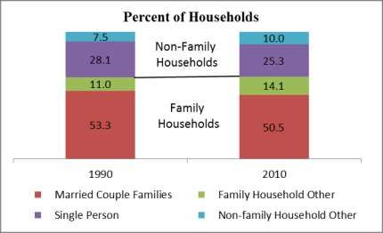
Montgomery Town Plan 2016-2021

adopted every five years. This process should be ongoing, whereby the Plan is continually
reassessed and revised to meet the changing needs of the community. Consequently, there will
be future opportunities to review and amend the plan. Residents, community groups, or anyone
with an interest in the Town is encouraged to provide input into this ever-continuing process to
the Montgomery Town Planning Commission at any time.

Planning Process

A Montgomery Town plan was developed and adopted in 1974. The plan was later amended in
1987, 1994, 2000, 2005 and 2010. The Town began this latest revision in 2015, with some
assistance from the Northwest Regional Planning Commission.

Under current law, Act 200, a municipality must address twelve (12) elements in its plan
development which are the following: a statement of objectives, policies, and programs of the
municipality to guide the future growth and development of land, public services and facilities,
and to protect the environment; a land use plan; a transportation plan; a utility and facility plan; a
statement of policies on the preservation of rare and irreplaceable natural areas, scenic and
historic features and resources; an educational plan; a recommended program for the
implementation of the objectives of the development plan; a statement indicating how the plan
relates to development trends and plans for adjacent municipalities, areas and the region
developed under this title; an energy plan; an economic development element; a flood resilience
plan; and a housing element that shall include a recommended program for addressing low and
moderate income person’s housing needs. In order to develop regulatory mechanisms (by-laws)
appropriate to guide development, a plan must first be adopted by the Town Selectboard. Once
adopted, the Plan becomes the basis for development and enactment of zoning and subdivision
regulations.

Role of the Montgomery Planning Commission

The Planning Commission is empowered to formulate goals and objectives toward Plan
development. The Commission is responsible for the review and revision of the town plan and to
propose amendments to the zoning bylaws and regulations in an effort to implement the plan, and
nominates the zoning administrator with appointment by the Selectboard. The Commission also
works on community development programs, grant applications and other projects that further
the goals of this town plan.

The role of the Commission is ongoing. Changing community conditions, preferences and
priorities call for consistent monitoring of plan objectives. Amendments to the plan may, from
time to time, be necessary and the Commission has responsibility for this task.

                                                                                                    2
Montgomery Town Plan 2016-2021
CHAPTER 2. Visions for the Future of Montgomery
Montgomery is defined by the natural character which surrounds us, by our history, and by the
community of people that call our broad valley at the northern end of the Green Mountains home.
Surrounded on three sides by pristine ridge lines, enveloped in woodlands, and threaded by wild
and scenic brooks flowing into the Trout River, our town expands from two village centers along
rural back roads. Transformed through the last century by growth and development, including
shifts in economy and culture, our covered bridges and historic buildings still serve as icons of
our heritage, and provide a testament to a past driven by agriculture and a vibrant wood products
industry. Our sense of community is strong. We value our connections with each other through
the arts, local entertainment, and a willingness to support our neighbors and the community that
binds us. We are proud of what we as a community have created together, assets like our top
ranked school, library, and recreation center, and the traditions which bring us together around
food and drink in celebration of this place and its people. We are blessed by what the natural
world has provided us, from our vast forests and the myriad of wildlife species which share them,
to our smallest swimming holes and the pleasures found there. As we consider our plan for the
future we are charged with balancing the stewardship of our past with shaping a vision for
growth which sustains these elements which define our town.
A Vision of the Future
Our vision is of a strong and sustainable local economy which maintains Montgomery’s
uniqueness of character and celebrates our history. An economy driven by a growth of local
enterprise, responding to new technologies, and based in diversification of value added
manufacturing, community scaled agriculture, and tourism based on our natural environment. A
vision of a community resilient to the effects of a changing climate, prepared for more intense
storm events and increased flooding, and acknowledging the importance of renewable energy
development on a local, non-industrial scale, with sound stewardship of our woodlands and
waters to ensure their health and productivity into the future.
3Montgomery Town Plan 2016-2021
CHAPTER 3. Summary of Goals and Policies
ARCHAEOLOGICAL, HISTORIC, AND SCENIC RESOURCES
GOAL: TO RECOGNIZE THE ROLE OF MONTGOMERY'S
ARCHAEOLOGICAL, HISTORIC, AND SCENIC RESOURCES IN SHAPING
THE TOWN'S PRESENT QUALITY OF LIFE AND FUTURE OPPORTUNITIES
Policies
Protect sites of potential archaeological and/or historical significance
Promote community growth that maintains the land use pattern developed throughout the
Town’s history – densely settled villages separated by open agricultural and forest land
Promote the use of historic buildings for public purposes whenever feasible
Preserve the scenic beauty and rural character of Montgomery’s ridgelines, forests, open
lands, and roads
COMMUNITY FACILITIES
GOAL: TO LOOK AHEAD AND PREDICT FUTURE NEEDS FOR PUBLIC
FACILITIES BASED UPON COMMUNTIY GROWTH AND CHANGE
Policies
Promote efficient and functional use of existing municipal buildings and facilities
Provide sufficient space and facilities to carry out essential municipal functions
Provide a gathering place for the local population to address town business
Conserve Montgomery’s recreational resources, discourage incompatible land uses, and
protect the scenic qualities that contribute to recreation
Promote recreational areas and facilities in convenient and reasonable locations for the
use and enjoyment of all residents and visitors
Promote the protection and maintenance of public recreation trails within the town on
private land, including the Catamount Trail, a cross-country ski trail that runs the length
of Vermont
Provide space for gatherings, functions, and events to provide educational, social, and
civic opportunities to enhance community involvement and identity
4Montgomery Town Plan 2016-2021
COMMUNITY SERVICES
GOALS: TO PROVIDE MUNICIPAL SERVICES, OR ENABLE OTHER ENTITIES TO
MEET THE NEEDS OF LOCAL RESIDENTS OF ALL AGES WITHOUT UNDUE OR
SUDDEN IMPACTS UPON LOCAL PROPERTY TAXES
Policies
Provide emergency services to protect the health, safety, and property of local residents
Provide library services to enable Montgomery residents access to information, resources,
and opportunities for personal and community enrichment
Encourage safe and affordable childcare facilities in the community
COMMUNITY UTILITIES
GOAL: TO PROVIDE PUBLIC UTILITIES TO SUPPORT CONCENTRATED
COMMERCIAL, AND LIGHT INDUSTRIAL DEVELOPMENT.
Policies
Protect the public water supply by restricting inappropriate development in the source
protection area
Operate the Montgomery Water System in an economic manner, while providing an
adequate source of good potable water for the needs of the Village and Center
Promote the expansion of telecommunications and electric facilities provided that
infrastructure to develop these opportunities shall be located in appropriate areas;
respecting the integrity of residential areas, aesthetic concerns, and natural resource issues
ECONOMY
GOAL: TO FOSTER A DIVERSE AND STABLE ECONOMY BY HELPING TO
ENSURE THE SUCCESSFUL OPERATION OF EXISTING ECONOMIC
ACTIVITIES AND PROVIDING OPPORTUNITIES FOR NEW ONES
Policies
Support and encourage sustainable and diversified activities to supply local and regional
food needs
Encourage businesses that complement recreation opportunities within the town
Protect the vitality and importance of the villages as a community and regional asset
Encourage commercial development that supplies local needs for retail, business, and
personal services
Encourage and develop resources for home occupations
Encourage Montgomery’s growing arts community
Encourage businesses and industries that use the skills of the local labor force
Create an attractive, safe and friendly village environment that invites and supports safe
pedestrian use, community events and an active lifestyle
5Montgomery Town Plan 2016-2021
ENERGY
GOAL: TO PROMOTE ENERGY CONSERVATION AND THE DEVELOPMENT
OF LOCAL ENERGY PRODUCTION
Policies
Make Town owned buildings as energy efficient as feasible
Encourage the development of renewable energy resources, including the heating of
municipal facilities
Promote car-pooling among area residents; encourage the use of informal park and ride
lots where possible
Encourage energy conservation by promoting patterns of development that utilize
clustering and energy efficient site design whenever possible
Encourage energy efficiency by making available information regarding groups and
organizations in the State, which can provide consumers with information on how to
become more energy efficient
Support renewable energy systems that are appropriately sited and scaled and which are
consistent with the environmental, aesthetic and cultural values of Montgomery and with
considerations to no undue adverse impact upon the important scenic and natural
resources outlined in this plan
TRANSPORTATION
GOAL:
TO ENSURE THE DEVELOPMENT OF A FUNCTIONAL AND CONNECTED
TRANSPORTATION NETWORK.
Policies
Protect the health, safety, and welfare of the traveling public
Promote safe, convenient, economic, and energy efficient transportation systems
including public transit options and paths for pedestrians and bicycles
Promote transportation activities that respect the natural environment
Maintain the scenic character of the Town’s rural byways
Support public transit efforts of the Green Mountain Transit Agency to increase mobility
and access of Town residents
Provide appropriate provisions for bicycle and pedestrian use on designated routes,
including sidewalks, paths, widen shoulders, proper signage and pavement
improvements.
Maintain good quality, safe local roads and streets, sidewalks, bridges, and equipment
needed for their maintenance.
Recognize the link between land use and transportation and coordinate transportation
improvements to facilitate and complement the desired type, location, density, and timing
of local development.
6Montgomery Town Plan 2016-2021
EDUCATION
GOAL: TO CREATE A LEARNING COMMUNITY THAT WILL PROVIDE
OUR STUDENTS WITH THE TOOLS FOR LIFELONG SUCCESS
Policies
Provide appropriate facilities and infrastructure for a variety of academic, athletic, social,
cultural and community activities
Broaden access to educational and vocational training opportunities for all ages
Ensure that both motorized and pedestrian access to school is safe and convenient
Support use of town lands, facilities, and resources for broad-based educational
experiences
HOUSING
GOAL: TO PROVIDE SUITABLE LAND AREAS FOR RESIDENTIAL
DEVELOPMENT THAT WILL SERVE THE NEEDS OF MONTGOMERY’S
CURRENT AND FUTURE RESIDENTS
Policies
Ensure adequate housing options for people of all income levels, ages, household types,
and preferences
Ensure that households and individuals with special housing needs, including the elderly,
handicapped, and low-income households are able to attain suitable and affordable
housing
Promote low-density residential housing in areas without municipal services and higher
densities in parts of town with existing services or close to existing service boundaries
Conserve and protect the vitality and quality of existing neighborhoods
Allow for innovative housing to promote low-cost, low-impact, consolidated, and
resource efficient options.
Accessory apartments are encouraged, as they provide needed income for the homeowner
and needed small apartments for residents living alone
Affordable housing should minimize long-term living costs through high quality design,
efficient construction, energy efficiency, and proximity to employment
Encourage land use patterns which are inherently more affordable by nature of cost of
efficiencies associated with construction (e.g. shorter access roads, smaller lots, proximity
to utilities)
Existing housing in the floodplain should be flood-proofed for the safety of the residents
and the Village as a whole
7Montgomery Town Plan 2016-2021
NATURAL RESOURCES
GOAL: TO PROVIDE FOR THE LOCAL GROWTH THAT IS COMPATIBLE
WITH THE TOWN’S NATURAL FEATURES INCLUDING SOILS,
LANDSCAPE, WATER RESOURCES & WILDLIFE
Policies
Limit development in areas where soils have limited capacity to support structures or
filter wastes and in areas where the slope is greater than 15%
Maintain natural vegetative cover to the greatest extent possible where development
occurs in Conservation Districts (Conservation I and II)
Guide development away from productive agricultural or forest soils
Protect the water quality of the Trout River and its tributary streams by preventing
erosion along their banks and encouraging reduction of stormwater and agricultural
runoff and non-point source pollution
Protect groundwater quality by regulating uses that could introduce contaminants into
the ground in the source water protection areas
Limit the loss or degradation of wildlife habitat by maintaining significant features,
including wildlife corridors and unique sensitive areas or natural communities, and
protecting such areas from development that would demonstrably reduce the
ecological function of habitat on the landscape scale
Development shall be designed and sited in a manner to limit the fragmentation of
large blocks of contiguous forest to the greatest degree possible
Prohibit land development resulting in the loss of wetland and floodplain storage
capacity
Recognize the collective value in preserving natural resources throughout the town
and encourage good land stewardship practices among private landowners in matters
of soil health, biodiversity, and water quality
Ensure the conservation and proper stewardship of significant natural communities
and our forestland
Avoid development and other encroachments – including fill, dredging, new
structures, parking areas, infrastructure and utilities – within mapped river corridors
Protect headwaters and the ecosystems they sustain from risk of degradation; to
ensure high water quality, these areas shall be principally maintained for forestry and
recreational uses
Incorporate vegetated buffers from streams, rivers and ponds into Montgomery’s
zoning bylaws in order to better protect water quality
8Montgomery Town Plan 2016-2021
FLOOD RESILIENCY
GOAL: ENCOURAGE AND FOSTER A FLOOD RESILIENT COMMUNITY
GOAL: MITIGATE THE RISK FOR LOSS OF LIFE AND INJURIES THAT
RESULT FROM FLOOD EVENTS
GOAL: REDUCE DAMAGES TO PUBLIC INFRASTUCTURE RESULTING
FROM FLOOD EVENTS THROUGH HAZARD MITIGATION PLANNING AND
PROJECT IMPLEMENTATION
Policies
Encourage flood emergency preparedness and response planning
Where development already exists in vulnerable areas, measures shall be taken to protect
people, buildings and facilities to reduce future flooding risk
New development shall be planned for and encouraged in areas that are less vulnerable to
future flooding events
Discourage new development in the Special Flood Hazard Area and river corridors; in
areas where new development is allowed, it should not exacerbate flooding and fluvial
erosion
Encourage the protection and restoration of floodplains and upland forested areas that
attenuate and moderate flooding and fluvial erosion; where feasible floodplain restoration
and conserved land in vulnerable areas should be encouraged
LAND USE
GOAL: TO MAINTAIN MONTGOMERY’S RURAL CHARACTER AND
SCENIC RESOURCES BY ENCOURAGING DEVELOPMENT TO FOLLOW
WISE LAND USE PRACTICES
Policies
Maintain the character of existing neighborhoods and avoid potential conflicts between
incompatible land uses
Limit development on slopes greater than 15% and maintain natural vegetation on slopes
Protect scenic ridges by limiting development above 1,600 ft. in elevation
Steer development away from areas where soils will not support it due to shallow depth
to bedrock, instability, or high water table
Protect public health, welfare, and safety by limiting development in the flood plain
Protect water quality by limiting development in Wellhead Protection Areas, wetlands,
and along stream banks
Conserve productive lands by accommodating development in areas apart from most
farming activity
Recognizing the community’s susceptibility to flooding, new development shall conform
9Montgomery Town Plan 2016-2021
strictly to floodplain regulations
Promote new development in areas of existing infrastructure, such as roads, power, and
water.
Encourage sustainable agricultural and silvicultural practices to both protect the use of
land and water resources, and keep a working rural landscape based on a practice of
stewardship
Avoid fragmentation of large forest blocks of contiguous forests that provide both
economic opportunities for landowners as well as ecological and cultural benefits to the
community, including wildlife habitat, water quality maintenance and recreation
Promote anti-sprawl initiatives as a measure to maintain the appropriate use of our land
resources
Promote the enrollment of productive farm and forestland in the current use value
appraisal program.
10Montgomery Town Plan 2016-2021
CHAPTER 4. Community Profile
To understand and plan for a town, one must understand the people who live there. The
members of a town will vary in age, place of birth, income, and occupation but all are members
of a community. This chapter provides a snapshot of many social and economic indicators that
will be discussed in greater detail in other parts of the plan. The purpose here is to understand the
mix of individuals that make up the community as it exists today in order to plan for the future.
The Town of Montgomery is located in the northwestern part of the State of Vermont in Franklin
County. It is bordered by the following eight towns: Richford, Enosburg, and Bakersfield, (all
located in Franklin County); Belvidere and Eden (both located in Lamoille County – to the south
of Franklin County); and finally, Lowell, Westfield, and Jay (all three are located in Orleans
County – to the east of Franklin County). Montgomery covers a total of 57 square miles – which
includes the Trout River and numerous streams and brooks. This amounts to 8.2 percent of the
total area of Franklin County. The total area in Franklin County is 693 square miles, of which 56
square miles is water.
Past, Present and Future Population
Planning is related to people and because of this, an understanding of their geographical
distribution is essential. Population growth is the result of two factors: natural increase (where
the number of births exceed the number of deaths) and/or net in-migration (where the number of
people moving into a community exceeds the number of people moving out). The Town of
Montgomery has experienced moderate growth in its population since the 1980’s. Population
changes for the Town have occurred steadily over the years.
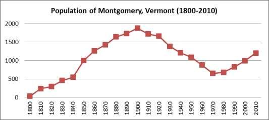
The graph below shows Montgomery’s population grew steadily from the year 1800 to the year
1900 where it peaked. In the early 1900s the population started to see a decline until 1980, where
once again it has started to rise moderately.
Data Source: US Decennial Census
11Montgomery Town Plan 2016-2021
The small size of the population
base makes long-term forecasting
difficult, especially at the local
level. Population trends since
1970 show that in-migration,
driven in part by continued
economic growth and
development, will continue well
into the next century, but natural
increases will level off somewhat,
given the overall aging of the
population. Since the 1980s, the
in-migration is accounting for the
majority of the population growth.
D
Data Source: Vermont Health Department, Vital Statistics
According to the U.S. Census reported population, Montgomery has been growing at a rate of
twenty-one percent for the past three decades. The growth in Montgomery has been steadier than
the surrounding communities leading up to 2010, and a much higher percent increase than
Franklin County from 2000 to 2010 which saw a five percent population increase.
1980 % 1990 % 2000 % 2010
Montgomery 681 21 823 21 992 21 1,201
Richford 2,206 -1.3 2,178 7 2,321 -0.6 2,308
Enosburgh 2,070 22 2,535 10 2,788 -0.3 2,781
Bakersfield 852 15 977 24 1,215 9 1,322
Eden 612 37 840 37 1,152 15 1,323
Lowell 573 4 594 24 738 19 879
Westfield 418 6 442 14 503 7 536
Belvidere 218 5 228 29 294 18 348
Data Source: US Decennial Census
Population projections are based on past trends in birth, deaths and migration which provide
reasonable estimates of future conditions. The Vermont Agency of Commerce and Community
Development produced a report calculating projections based on past trends from two time
periods; the 1990-2000 predict higher growth and 2000-2010 predicts lower growth. Based on
these projections, Montgomery could experience continued growth of twelve to seventeen
percent by 2020. Franklin County as a whole is projected to see closer to three to nine percent
growth by 2020.
12Montgomery Town Plan 2016-2021
Data Source: U.S. Census; Vermont Population Projections 2010-2030 Report, released August 2013.
Age Distribution of Residents
The median age in 2010 for the residents of Montgomery was 42.5 years, an increase of 6.1 years
since 1990. This trend is similar to other communities in Franklin County and the State of
Vermont as the
population as a
whole is aging. As
noted previously,
the total population
of the community
has been increasing
however the
proportion of the
population in each
age group has
remained stable
from 1990 to 2010.
Data Source: US Decennial Census
Special Populations
The 2010 US Census provides information about the number of people with various levels and
types of disabilities. Nineteen percent of the town population has a disability as classified by one
of the six categories: hearing, vision (blind or having serious difficulty seeing, even when
wearing glasses), cognitive, ambulatory (mobility), self-care difficulty, and independent living
difficulty. Montgomery has a higher percentage of persons between the ages of 18 and 64 with
disabilities (22.5% of this age group), than that of the county and the state.
13Montgomery Town Plan 2016-2021
Households & Household Types
The way the population groups itself into households affects the demand for housing, community
services, and employment. From 1990 to 2010, the percentage of family households to non-
family households remained unchanged in Montgomery following a dip in family households
from 1980 to 1990. Non-family and single households have continued to increase in the county
and state.
Family Household - A
householder living with one
or more individuals related to
him or her by birth, marriage,
or adoption
Non-Family Household -
A householder living alone,
with an unmarried partner, or
with nonrelatives.
Data Source: US Decennial Census
The increase in single-family households impacts the average number of persons per household.
This number decreased in Montgomery from 2.41 to 2.36 since 2000. A decrease means that
more units are required to shelter the same number of people. As the population continues to
increase, we expect an on-going demand for housing units. The majority of the community’s
housing units can be characterized as single-family structures.
In 2000, Montgomery needed approximately 412 housing units to house the 2000 population,
while the Town held a stock of 441 year round housing units. With the 2010 household size of
2.36, 509 year round housing units would have been needed to accommodate growth and 558
units were reported by the Census. If one assumes household size stabilization at about 2.4 in
Montgomery through the year 2030, and in consideration of population projections for the town,
approximately 30 additional housing units will be needed by 2020 and 49 up to 78 new units to
house the projected population for 2030.
% Change %Change % Change
1980 1990 2000 2010
1980-1990 1990-2000 2000-2010
Total Households 253 345 412 509 36.4 19.4 23.5
Total Housing Units 485 556 666 791 14.6 19.8 18.8
Data Source: US Decennial Census
14Montgomery Town Plan 2016-2021
Economic Standing
Sixty-six percent of the population 16 years old and older is in the labor force as of 2013 (ACS
2009-2013) which equates to the proportion of the population that is 18-64 years old. Fifty-six
percent of 25 to 64 year olds have attended some college or obtained a degree (Associates,
Bachelors or higher).
The median household income for Montgomery is below the The Census defined Poverty
median household incomes for both Franklin County and Threshold in 2013 for a two-
Vermont. Montgomery does have an increasing percent of adult family with one child under
families that are below the poverty level, this percent has 18 years old is $16,057.
increased since 1999.
% of Families
Median Household Income
Below Poverty Level
1989 1999 2013 1999 2013
Montgomery $22,019 $33,958 $38,000 8.70% 14.00%
Franklin County $28,401 $41,659 $56,240 7.00% 7.70%
Vermont $29,792 $40,856 $54,267 6.30% 7.60%
Source: US Census of Population 1980-2000; American Community Survey 2009-2013
Commuting to Jobs
In the 1990s, the majority of Montgomery and Franklin County residents has less than a 20
minute commute to work. By 2013, the majority of residents still maintain a travel time of less
than 30 minutes for work.
Montgomery Franklin County
1990 2000 2013 1990 2000 2013
Minutes to Work Percent of Workers by Travel Time to Work (%)
Less than 10 minutes 32.7 14.7 17.2 25.1 21.6 16.7
10 – 14 minutes 12.1 9.6 8.6 14.1 12.6 12.2
15 – 19 minutes 15.8 16.2 11.6 13.0 10.8 11.7
20 – 29 minutes 15.8 14.7 14.7 12.9 14.6 13.8
30 – 44 minutes 9.3 11.7 18.6 21.1 23.1 25.6
Greater than 45 min. 14.4 18.2 29.3 13.9 15.1 19.9
Mean Travel Time to Work (mins)
20.5 33.3 30.5 21.6 25.6 27.1
Source: US Census of Population 1990 and 2000; American Community Survey 2009-2013
The percentage of workers in Montgomery and the county who drove alone to work (using either
a car, truck, or van) has been creeping higher since 1990. The Town does not have direct access
to public transit; the closest service is in Berkshire on the transit route that connects Richford to
15Montgomery Town Plan 2016-2021
St. Albans City. The percentage of people who work from home or use non-motorized means of
travel has continued on a downward trend.
Transportation Type Used in Montgomery Franklin County
Commuting to Work 1990 2000 2010 1990 2000 2010
% who drove alone 64.4 70.5 75.5 66.7 73.3 77.6
% in carpools 12 14.5 12.3 17.4 16.5 12.7
% using public
1 0.5 0 0.6 0.2 0.4
transportation
% using other means 1.6 0.9 0 1.3 0.3 0.9
% who walked, biked, or
21 13.7 8.4 13.9 9.7 12.2
worked at home
Source: US Decennial Census
Grand List
The Grand List can give a town an idea of what the land is being used for and also, how the land
uses have changed over time. It will show how many parcels there are and different types of
housing (vacation, residential, mobile homes, etc.), and it will show the number of parcels for
commercial, industrial, forestry, utilities, and farms. The Grand List also shows the appraised
value of all of the parcel categories. The Town of Montgomery currently has a total of 943
parcels for the year 2014. The largest category is Residential with 631 parcels or 67 percent of
the total. Woodlands (Forestry) is the second largest category with 144 parcels or 15 percent of
the total, while Vacation/Seasonal is the third largest with 55 parcels or 6 percent of the total.
The Residential category also has the highest appraised value (83%) followed by Woodland
(forestry) (5%). Overall the grand list has stayed relatively similar since 2009; there has been a
small decrease in the number of woodlands parcels. The Grand List for Montgomery (2014)
which lists the categories and their appraised values can be found in the Table below.
16Montgomery Town Plan 2016-2021
2009 and 2014 Grand List for Montgomery, Vermont
Category # of Parcels % of Total Appraised Value of Category % of Total
200 201
9 4 2009 2014 2009 2014 2009 2014
$129,817,90
Residential 618 631 65.19% 66.91% $95,437,000 0 82.25% 82.52%
Mobile
Home 37 31 3.90% 3.29% $2,053,700 $2,161,800 1.77% 1.37%
Seasonal 55 55 5.80% 5.83% $3,036,900 $4,108,459 2.62% 2.61%
Commercia
l 23 27 2.43% 2.86% $2,652,300 $4,386,100 2.29% 2.79%
Industrial 0 0 0.00% 0.00% $0 $0 0.00% 0.00%
Utilities 2 2 0.21% 0.21% $2,282,000 $3,587,500 1.97% 2.28%
Farm 7 7 0.74% 0.74% $165,500 $2,515,533 0.14% 1.60%
Woodland 159 144 16.77% 15.27% $7,119,700 $8,455,311 6.14% 5.37%
Misc. 47 46 4.96% 4.88% $1,793,900 $2,289,805 1.55% 1.46%
Other 0 0 0.00% 0.00% $0 $0 0.00% 0.00%
100.00 100.00 $116,026,00 $157,322,40 100.00 100.00
Total 948 943 % % 0 8 % %
Source: Vermont Department of Taxes
17Montgomery Town Plan 2016-2021
CHAPTER 5. Archaeological, Historic, and Scenic Resources
GOAL: TO RECOGNIZE THE ROLE OF MONTGOMERY'S
ARCHAEOLOGICAL, HISTORIC, AND SCENIC RESOURCES IN SHAPING
THE TOWN'S PRESENT QUALITY OF LIFE AND FUTURE OPPORTUNITIES
Policies
Protect sites of potential archaeological and/or historical significance.
Promote community growth that maintains the land use pattern developed throughout the
Town’s history – densely settled villages separated by open agricultural and forest land.
Promote the use of historic buildings for public purposes whenever feasible.
Preserve the scenic beauty and rural character of Montgomery’s ridgelines, forests, open
lands, and roads.
Town History
The Town of Montgomery was named after Captain Richmond Montgomery, a hero of the
American Revolution. It was chartered on March 13, 1780. Montgomery is situated within the
northern Green Mountains and is dominated by steep, forested mountain slopes drained by the
Trout River and its tributaries. The first people who moved to the Town of Montgomery settled
along this area. Five small villages also referred to as hamlets, eventually formed along the river.
These hamlets are known today as West Hill, Montgomery, Montgomery Center, Hutchins, and
Hectorville.
Spurred by abundant waterpower and surrounding raw materials, the population grew steadily
until 1900. At this time, the population started to decline until the 1970’s, when it slowly started
to rebound. Early economic activity in Montgomery centered on farming, sugaring, logging, and
small wood related industries. As these industries changed, so did Montgomery’s population.
More recently, Montgomery’s economy has begun to grow again due to the development of
recreation and tourist industries. Since 2000, we have seen a shift from a greater percentage of
vacation homes to a greater percentage of residential homes. The Town also receives a noticeable
influx of retirees from other parts of the United States and Canada. This trend is likely to
continue for the foreseeable future.
Cultural and Historic Resources
Covered Bridges
Vermont regards its covered bridges as one of its most treasured landmarks. The State has more
covered bridges in proportion to its area than any other state. The bridges were covered for two
purposes: to protect them from the elements of nature and to preserve the wooden trusses used in
their construction. Unfortunately, many of the states' covered bridges have succumbed to the
forces of nature and also to neglect. It is vital that the State takes active measures to preserve
these valuable landmarks.
18Montgomery Town Plan 2016-2021
The Town of Montgomery has six covered bridges that are considered historic sites. They are the
following: Fuller (1890), Comstock (1883), Hectorville (1883), Longley (1863), Creamery
(1883), and Hutchins (1883). The Fuller Covered Bridge is also known as Black Falls and the
Creamery Covered Bridge is also known as West Hill or Crystal Springs. The Jewett brothers,
Sheldon and Savannah, built all of Montgomery’s covered bridges between 1860 and 1890. They
operated a sawmill on West Hill which allowed them to mill the wood to their specific
requirements. Stress, wind, and weight were all factors that had to be taken into account when
designing the bridges. The brothers used their trademark method to design the bridges. First, the
main bearing beams were positioned across the stream onto a pier foundation on either end. Then
the lattice trusses were moved into position and the top beams tied. After this, the roof was
secured. The Jewett brothers were able to build bridges that have lasted over a hundred years. All
six of these bridges are listed on the National Register of Historic Places. The following chart
gives the location, type, the year built, and crossing for the covered bridges in Town:
Historic Covered Bridges in Montgomery
Name Location Type Year Crossing
Built
Fuller Bridge South Richford Road Town 1890 Black Falls Brook and
Montgomery Village Lattice South Richford Road
Creamery Creamery Bridge Road Town 1883 West Hill Brook and
Bridge Montgomery Village Lattice Creamery Bridge Road
Hectorville Disassembled, and in Town 1883 South Branch of the Trout
Bridge storage awaiting a plan Lattice River and the Gibou Road
for restoration
Comstock Comstock Road Town 1883 Trout River and
Bridge Montgomery Village Lattice Comstock Road
Hutchins Hutchins Bridge Road Town 1883 South Branch of the Trout
Bridge Montgomery Center Lattice and Hutchins Bridge Road
Longley Bridge Longley Bridge Road Town 1863 Trout River and Longley
Montgomery Village Lattice Bridge Road
Source: Montgomery Historical Society
Historic Buildings
St. Bartholomew’s Episcopal Church and the Montgomery House (formerly the Black Lantern
Inn) are also listed on the National Register of Historic Places. Their years of inclusion are 1988
and 1992 respectively. The St. Bartholomew’s Episcopal Church, also known as the Union
Church, was built in 1835 at a cost of three thousand dollars. Membership thrived at the church
until 1882 when, for the first time, it started to decline. By 1920, the church was no longer being
19Montgomery Town Plan 2016-2021
used on a regular basis, and thus began a long, slow process of deterioration. The Town
responded to the need to save the historic building for future generations. On November 23,
1974, the Town of Montgomery formed the Montgomery Historical Society. The Society then
proceeded to purchase the church from the Episcopal Diocese of Burlington for the sum of one
dollar. The church was later renamed Pratt Hall in honor of one of the founders, Larry Pratt. All
the necessary repair work that was done on the building was funded through community
donations and fund-raising events. See Chapter 16, Volunteer Community Organizations for
more on the Montgomery Historical Society.
Smaller landscape features such as stone walls, old barns, outbuildings, corner stones, markers,
trees, and old apple orchards and lilac bushes planted around former homesteads, all have
historic value and importance but these unfortunately often go unnoticed. These features say as
much about the region’s rural and agricultural heritage as many of its more readily recognized
historic landmarks, but are often disturbed, removed, or demolished without any thought.
Recognizing the need for more public education, the Vermont Department of Forests, Parks, and
Recreation published in 1994 Stonewalls and Cellarholes: a Guide for Landowners on Historic
Features and Landscapes in Vermont’s Forests.
Cultural and historic resources are at risk of degradation through improper earth resource
extraction. This includes the accidental destruction of buried archaeological sites and diminished
scenic qualities that may limit the future use of disturbed sites. Noise, dust, and increased traffic
on roads near extraction sites all compromise the rural character and sense of place the Town
enjoys.
Scenic Resources
The Northwest Region of Vermont is an extremely rich visual mosaic of diverse landscapes,
from the sweeping agricultural views of the Lake Champlain islands, to the heavily wooded
Western slopes of the Green Mountains. It is the visual language of the area which plays an
important part in how a community is perceived.
Scenic highways and corridors link natural, cultural, and scenic resources to the historic
landscape of the area. The visual character of Montgomery makes it an excellent place to live.
Montgomery, like all other towns, should maintain the preservation of scenic vistas. The scenic
qualities of a forested ridgeline or hillside can be compromised by poorly planned development,
such as inappropriate building placement, site design, and excessive clearing. The Town should
encourage innovation in design and layout of development so that the visual impact can be
minimized. The use of vegetative buffers and other screening methods should be encouraged to
help reduce the visual impact of development in the town.
Montgomery shall take measures to ensure that its natural features are conserved. These natural
areas include the Trout River and its tributaries, its mountains such as Burnt Mountain, Big Jay,
and Little Jay, as well as farm and forest land. These natural features play a big role in drawing
people to the area and they should not be compromised.
20Montgomery Town Plan 2016-2021
CHAPTER 6. Community Facilities
GOAL: TO LOOK AHEAD AND PREDICT FUTURE NEES FOR PUBLIC
FACILITIES BASED UPON COMMUNITY GROWTH AND CHANGE
Policies
Promote efficient and functional use of existing municipal buildings and facilities
Provide sufficient space and facilities to carry out essential municipal functions
Provide a gathering place for the local population to address town business
Conserve Montgomery’s recreational resources, discourage incompatible land uses, and
protect the scenic qualities that contribute to recreation
Promote recreational areas and facilities in convenient and reasonable locations for the
use and enjoyment of all residents and visitors
Promote the protection and maintenance of public recreation trails within the town on
private land, including the Catamount Trail, a cross-country ski trail that runs the length
of Vermont
Provide space for gatherings, functions, and events to provide educational, social, and
civic opportunities to enhance community involvement and identity
Public Buildings (Town Office, Town Garage, Public Safety Building)
The Town Office building is located on Main Street in the Center. One half of the main floor of
the one story building provides space for the Town Clerk’s office with a walk in vault, and a
large conference room which also serves as the Listers and Zoning Administrators offices. The
remainder of the main floor is leased by the US Postal Service. The basement has a walk in vault
for storage of Town records, and it has a furnace room; this space has been deemed unusable for
records storage due to flooding concerns. The Town has identified that the current Town Office
is not meeting the needs of the Community; there are space constraints in the Town vault, office
space for staff and additional meeting space is needed. The Town is currently considering
options for relocating the Town Office.
The former Grange Hall, located on Main Street in the Center, is now referred to as the Town
Hall. It is used for Town meetings, by individuals and groups for social functions, large
gatherings, and fundraisers.
The Public Safety Building, a one-story building located on Route 242, houses the Fire
Department, Rescue Squad, Health Office, and Montgomery Town Library.
The Fire Department has three large bays for trucks and equipment.
The Rescue Squad has one ambulance bay and space for storage.
There is also a kitchen, conference room, small first aid room, electrical room, utility
room, and ample bathrooms.
The Library consists of one large room and a storage room, a portion of which has been
modified for a children’s area. The library Board of Trustees would like to pursue an
21Montgomery Town Plan 2016-2021
expansion project to provide additional space for the growing collection of books, audios
and videos; additional computers; a reading room for adults; and a larger children’s area.
A Public Works Building was built in 2010 for the Town Highway Department. This building
consists of a five-bay building and replaced the previous building from the 1970’s. The building
accommodates office space for the highway department and additional space for the highway
equipment and the Water Department truck. The current site of the town garage is in the
floodplain, the building was flood-proofed by elevating the building prior to reconstruction.
Recreation
Maintaining and developing Montgomery’s natural beauty and resources for recreational
purposes is an important part of the Town Plan. Montgomery has some of the most beautiful
hiking, hunting, and fishing areas in the State and the Town should make a concerted effort to
preserve these.
Water quality, for swimming and fishing, should be protected against adverse impacts
from development adjacent to streams and rivers.
Commercial development that compromises recreational resources should be
discouraged.
Montgomery should encourage the development of recreation areas in the regions defined
as suitable in the land use plan, as long as appropriate standards of attractiveness and
supplemental protection are maintained.
Currently, the Recreation Board manages the Town’s formal recreational activities. They work
with other volunteer groups in town to provide and maintain recreational facilities for use by the
entire town. For the purpose of this Plan, recreation is divided into three equally important
categories: sport recreation, wildlife recreation, and other outdoor recreation.
Sport recreation involves activities such as tennis, baseball, and soccer. The recreation center,
located near Montgomery Center on Route 118, has town tennis courts, a baseball/soccer field,
outdoor ice rink, basketball court, and limited room for other activities. There is also a one-story
log cabin with rest rooms and space for storage of equipment. A two-story memorial pavilion
has been built. There is a ball field/volley ball court in Montgomery Village.
Wildlife recreation involves activities such as hunting, fishing, trapping, and wildlife viewing.
The Vermont Department of Fish and Wildlife administers over 95,000 acres of wildlife
management areas which are open to the public for hunting and other outdoor recreational
activities. Potential users of these areas are responsible for making themselves familiar with all
rules, regulations, and restrictions before they can hunt or fish. Avery’s Gore, located in the
southern part of the Town, is one of these areas. It contains a total of 259 acres and has many
different types of game available for hunting. Such game includes black bear, deer, wild turkey,
gray squirrel, rabbit/hare, partridge, and woodcock.
Outdoor recreation activities include skating, downhill skiing, cross-country skiing,
22Montgomery Town Plan 2016-2021
snowmobiling, snowshoeing, hiking, swimming, mountain biking, and road biking. Within the
borders of Montgomery, there exists Little Jay (elevation 3180 feet) and Big Jay (elevation 3780
feet). There are several natural swimming holes in Montgomery.
Recognizing Special Resources. Fifty miles of the upper Missisquoi River and 20 miles of the
Trout Rivers were designated in 2014 as a Wild and Scenic waterbody. This designation
excludes the section of the Missisquoi River with the Enosburg Falls dam. The National Wild
and Scenic Rivers System was created by Congress in 1968 (Public Law 90-542) to preserve
certain rivers with outstanding natural, cultural, and recreational values in a free-flowing
condition for the enjoyment of present and future generations. This designation encourages river
management that crosses political boundaries and promotes public participation in developing
goals for river protection. In addition, it enables access to federal funding for projects to preserve
the recreational, scenic, historic, cultural, natural, and geologic resources of these rivers. It
should be noted that designation neither prohibits development nor gives the federal government
control over private property; recreation, agricultural practices, development and other uses are
permissible in this designated area.
There are several public and private recreational resources available to the community:
The Hazen’s Notch Association maintains about 40 miles of trails on over 2,000 acres. These
trails are used in summer and fall for hiking and in winter for cross-country skiing and
snowshoeing. The Association acts both as a local land trust for the Town of Montgomery, as
well as a stewardship partner with other regional and statewide land trusts. The 300-mile
Catamount Trail is a winter-use cross-country ski trail that passes through Montgomery as it
traverses the length of Vermont from Massachusetts to Canada.
The Covered Bridges Snowmobile Club maintains an extensive snowmobile trail network
throughout the town and works with landowners to maintain these trails and the permission for
use by snowmobilers.
The Towns of Jay and Westfield, located to the east of Montgomery, are home to the Jay Peak
Ski Area (elevation 3861 feet) which offers downhill skiing, cross-country skiing, and
snowboarding. Jay Peak is an important asset to the area because of the amount of tourism
activity that goes on at it. Although located in Jay, the Jay Peak Ski Area brings in more potential
tourists to their town and its bordering neighbors like Montgomery. Jay Peak owns
approximately 2,600 acres; of which 1,500 acres will remain forever wild by Jay Peak’s choice
and 1,100 of which is to be used for some type of development based on the Jay Peak Master
Plan. Presently, Jay Peak has built an 18-hole golf course, an indoor ice rink, and an indoor
waterpark since 2005. A four-season operation is vital to Jay Peak’s future and will have a very
positive impact on all of its neighboring communities as they provide more year round
employment for its staff, many of whom reside in or around Montgomery. Hiking is possible
throughout the Town and there are many trails for people to enjoy.
The Long Trail extends the length of the State of Vermont from Massachusetts to Canada. The
local chapter of the Green Mountain Club maintains hiking trails associated with this trail.
23Montgomery Town Plan 2016-2021
Catamount Trail is a 300-mile, winter-use trail open to the public for skiing and snowshoeing.
24Montgomery Town Plan 2016-2021
CHAPTER 7. Community Services
GOALS: TO PROVIDE MUNICIPAL SERVICES, OR ENABLE OTHER ENTITIES TO
MEET THE NEEDS OF LOCAL RESIDENTS OF ALL AGES WITHOUT UNDUE OR
SUDDEN IMPACTS UPON LOCAL PROPERTY TAXES
Policies
Provide emergency services to protect the health, safety, and property of local residents
Provide library services to enable Montgomery residents access to information, resources,
and opportunities for personal and community enrichment
Encourage safe and affordable childcare facilities in the community
Police Protection
The Vermont State Police (VSP) is the primary law enforcement agency responsible for public
safety in Montgomery; services are out of the St. Albans Field Station.
Fire Protection and Rescue Services
Firefighting and rescue services are two services that are absolutely essential for communities to
function. The Town of Montgomery currently has the following fire and rescue equipment:
2010 Pumper
1977 Pumper
Tanker: #1 1,500 gallons, 1 drop tank 1500 gallons, 1-4² 500 GPM, and 1-2 1/2² 250
GPM portable pumps
Rescue Van: Set of air bags, 8 SCBA with 8 spare tanks
Fire Protection Suits
Montgomery has a volunteer fire department located in the Public Safety Building on Route 242.
There are currently 12 volunteer members who serve on the fire department. The equipment
consists of two pumper trucks, one tank truck, one rescue van, and assorted smaller equipment,
which is capable of fighting a fire in any accessible area of the Town. The smaller pumper is
almost 40 years old and will need to be replaced within the next five years. The other future
needs of the fire department include the replacement of the rescue van and purchase of new fire
protection suits for the members.
The Town of Montgomery currently maintains an ambulance squad providing emergency
medical services to Town residents and the surrounding area as needed. At the beginning of
2010, Montgomery Rescue had eight active members, all volunteer EMTs or First Responders.
Richford Ambulance Service is contracted to provide EMS service to the Town when
Montgomery Rescue does not have an available crew. The squad maintains an ambulance
stocked with supplies and equipment to deliver advanced life support, and a rescue van with
additional equipment used for incidents with multiple patients or hazardous scenes.
25Montgomery Town Plan 2016-2021
Montgomery has a Local Emergency Operations Plan (LEOP) to help organize the Town in case
of an emergency. The LEOP contains basic emergency preparedness essential for responding to
local emergencies. It includes critical phone numbers, contact persons, and critical facilities.
Steps are listed in the Plan as to what to do in case an emergency arises. These plans also
provide a framework that allows municipalities to work collaboratively to assist each other
during a widespread event.
Library Services
The Montgomery Town Library Services includes five public access computers with high speed
internet, printer, free Wi-Fi, copy and fax machine, and digital projector with large screen. The
library houses approximately 9,000 items that range from books, audio books, movies, puzzles
and maps. There is also an inter-library loan service, a community bulletin board, and year round
programming for all ages. At present the library is open seven days a week, including volunteer
staffing.
The Town library meets public library standards set by the Vermont Department of Libraries.
The Library is supervised by a seven member board of trustees.
The library serves as a gathering spot for community groups to meet, sponsors art shows, hosts
guest speakers, and participates with other local organizations in planning community events.
Some examples of current offerings include:
Family friendly presentations throughout the summer at the Rec Center
A monthly Book to Film potluck supper and film showing
A story hour playgroup for moms and young children, sponsored by Building Bright
Futures.
A fenced in play yard for young children on the library lawn was completed in Spring of
2010.
Municipal Website
The Town maintains a basic municipal web site at http://www.montgomeryvt.us. Information is
available about a variety of Town Officers and Boards, including Warnings, Agendas and Minutes
of Meetings, as well as ordinances, policies, permits, etc. This site should be continued and
expanded, as time and expense allow, in order to better inform the public and improve
communication.
Solid Waste Disposal
Montgomery has been a member of the Northwest Vermont Solid Waste Management District
(NVSWMD) since the district’s inception in December 1987. The district operates a trash and
recyclables drop off every Saturday at the Public Safety Building. Additionally, the district
conducts special events for the disposal of problem wastes, such as tires, metals, bulky, and
household hazardous wastes. The district accepts computers and peripherals, other electronic
waste, and fluorescent bulbs at its Georgia facility.
26You can also read