MARLBOROUGH HAZARD MITIGATION PLAN UPDATE 2021 - (add) - Marlborough, New Hampshire - Town of Marlborough NH
←
→
Page content transcription
If your browser does not render page correctly, please read the page content below
MARLBOROUGH HAZARD MITIGATION
      PLAN UPDATE 2021
        Marlborough, New Hampshire

                     Approval Date
                         (add)
 Prepared by the Marlborough Hazard Mitigation Work Group
                            &

                        SWRPC
         Southwest Region Planning Commission
                   37 Ashuelot Street
                    Keene, NH 03431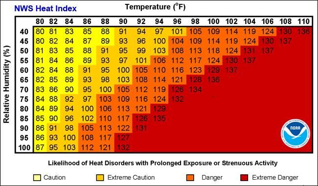
Marlborough Hazard Mitigation Plan Update 2021

                                                                   TABLE OF CONTENTS
Executive Summary.................................................................................................................................... 3
    1.     INTRODUCTION....................................................................................................................... 5
           Funding Source ................................................................................................................... 5
           Scope of the Plan ................................................................................................................ 5
           Methodology ....................................................................................................................... 5
           Public Work Group Meetings ............................................................................................. 6
           Public Participation ............................................................................................................. 7
           Resources Used in the Plan ................................................................................................. 7
           Plan Updates ....................................................................................................................... 8
           Acknowledgements ............................................................................................................. 8
           Hazard Mitigation Goals ..................................................................................................... 9
    2. COMMUNITY PROFILE ...............................................................................................10
           Town Overview .................................................................................................................10
           Disaster Risk ......................................................................................................................11
           Population Trends ..............................................................................................................11
           Population Projections .......................................................................................................11
           Development Patterns ........................................................................................................12
           Considerations for Development .......................................................................................12
           Current Development Trends.............................................................................................12
           Development in Hazard Areas ...........................................................................................13
           Changes in Development ...................................................................................................13
           Participation in NFIP .........................................................................................................13
           Continued Compliance with NFIP Requirements .............................................................13
    3.     ASSESSING PROBABILITY, SEVERITY AND RISK ..............................................14
           Risk Assessment ................................................................................................................15
    4.     HAZARD IDENTIFICATION AND POTENTIAL HAZARDS ................................... 16
           Flooding .............................................................................................................................16
           Drought ..............................................................................................................................17
           Extreme Temperature.........................................................................................................18
           High Wind, Tornado, Downburst ......................................................................................19
           Infectious Disease ..............................................................................................................20
           Lightning............................................................................................................................21
           Severe Winter Weather ......................................................................................................22
           Solar Storm and Space Weather ........................................................................................23
           Tropical Storm/Hurricane ..................................................................................................24
           Wildfire ..............................................................................................................................26
    5.     CRITICAL FACILITIES ....................................................................................................... 27
           Category 1 – Emergency Response Services .....................................................................27
           Category 2 – Non-Emergency Response Facilities ...........................................................28
           Category 3 – Facilities/Populations to Protect ...................................................................28
           Category 4 – Potential Resources ......................................................................................29

                                                                                                                                                     1
Marlborough Hazard Mitigation Plan Update 2021

6.   EXISTING MITIGATION STRATEGIES AND PROPOSED IMPROVEMENTS . 30
     Description of Existing Programs ......................................................................................30
     Integration of Mitigation Priorities into Planning and Regulatory Tools ..........................31
     Existing Protection Matrix .................................................................................................31
     Status of Previous Mitigation Action Plan ........................................................................34
7. PROPOSED MITIGATION STRATEGIES ....................................................................... 36
     Potential Strategies – Filling Gaps in Coverage ................................................................36
     Prioritization of Proposed Mitigation Strategies- STAPLEE Chart ..................................38
8. MITIGATION ACTION PLAN .................................................................................... 41
9.   ADOPTION, IMPLEMENTATION, MONITORING AND UPDATING ................44
     Monitoring & Updates ......................................................................................................44
     Implementation of the Plan Through Existing Programs ..................................................44
     Continued Public Involvement .........................................................................................45
     Certificate of Adoption ......................................................................................................46
     APPENDICES
     Hazard Description ............................................................................................ Appendix A
     Risk Assessment Description............................................................................. Appendix B
     Resources ........................................................................................................... Appendix C
     Federal Mitigation Resource Profiles and Mitigation Programs ....................... Appendix D
     Documentation of the Planning Process ............................................................. Appendix E
     Project Status Sheet............................................................................................. Appendix F

                                                                                                                                   2
Marlborough Hazard Mitigation Plan Update 2021
Executive Summary
The Marlborough Hazard Mitigation Plan serves as a means to reduce future losses from natural,
technological and human-caused hazard events before they occur. The Plan was developed by the
Marlborough Hazard Mitigation Work Group and contains statements of policy adopted by the Board of
Selectmen.
Hazards are addressed as follows:
• Flooding • Hurricane/Tropical Storm
• Drought • Wildfire
• Extreme Temperature • Aging Infrastructure
• High Wind (tornado, • Conflagration
downburst) • Known & Emerging
• Infectious Disease Contaminants
• Lightning • Hazardous Materials
• Severe Winter Weather/ • Long-term Utility Outages
Icing • Cyber Event
• Solar Storms and Space • Mass Casualty Incident
Weather • Transport Accident
Critical Facilities
• Emergency Response Facilities & Services
• Non-Emergency Response
• Facilities/Populations to Protect
• Potential Resources
The Marlborough Hazard Mitigation Work Group identified existing hazard mitigation programs in various
stages of development:
• School Evacuation Plan
• Town Master Plan
• Building Codes
• Capital Improvements Plan
• Emergency Operations Plan
• Code Enforcement Officer
• Emergency Back-up Power
• Local Road and Driveway Design Standards
• Fire Pond Management Plan
• Local Road Maintenance Program
• Floodplain Development Ordinance
• Winter Operations Guidelines
• Mutual Aid
• Dry Hydrant Maintenance
• Pressurized Hydrant Maintenance
• Participating Member of NFIP
• Participates in CRS Program
• Spill Prevention Control & Counter Measures Plan
• Point of Distribution (POD) Plan
• Erosion & Sedimentation Plan
• Tree Maintenance Program
3Marlborough Hazard Mitigation Plan Update 2021
• Town Radio System
• Shoreland Protection Act
• Steep Slope Development Regulations
• Local Bridge Maintenance Program
Prioritized Hazard Mitigation Strategies
• Inspect storm drains, culverts and dams prior to heavy rain events.
• Expand education to residents about emergency preparedness and hazard mitigation by adding
FEMA and NHHSEM links to the Marlborough website.
• Include the Hazard Mitigation Plan update into the appendix of the Master Plan.
• Review Hazard Mitigation Plan for projects and how it relates to CIP.
• Update the EOP in 2023.
• Seek funding for installing emergency generators at the pumping station on Pleasant Street,
Town Garage (secondary EOC) and Marlborough Community House.
• Trim tree branches near critical facilities, Town structures, and Town roads.
• Inventory culverts and bridges to determine needed upgrades.
• Maintain emergency resources for all hazardous events.
• Host a workshop for homeowners to learn of ways to mitigate the impact of extreme
temperatures such as insulation, windows, heating & cooling, etc. (NH Saves program, etc.)
• Conduct a workshop for providing information on ways to reduce the impact of hazards and to
make emergency preparedness kits.
• Provide a link on the Town website to NHDES regarding the Shoreline Protection Program.
• Continue to participate in NFIP trainings/workshops offered by the State and/or FEMA (or in
other training) that addresses flood hazard planning and management.
• Investigate steps needed to add the Marlborough Community House as an emergency shelter.
• Upsize culvert on Old Dublin Road.
• Upsize culvert on Dillingham Road.
• Improve ditching on Stone Pond Road.
• Include the Stormwater Wastewater Asset Management Plan as an appendix to this plan.
• Get construction level designs for repair and strengthening of the landslide area on Roxbury Road.
• Develop a written action plan for Jewett Street similar to Roxbury Road.
• Assess and install where needed, grounding equipment on public and historic buildings.
• Develop a protocol for determining closures and measures needed to protect the public during
infectious disease threats.
4Marlborough Hazard Mitigation Plan Update 2021
Chapter 1
Introduction
This Multi-Hazard Mitigation Plan was prepared pursuant to Section 322, Mitigation Planning, of the
Robert T. Stafford Disaster Relief and Emergency Assistance Act (the Act), herein enacted by Section 104
of the Disaster Mitigation Act of 2000 (DMA) (P.L. 106-390). This Act provides new and revitalized
approaches to mitigation planning. Section 322 of DMA 2000 emphasizes the need for State, local and
tribal entities to closely coordinate mitigation planning and implementation efforts. The development and
periodic update of this plan satisfies the planning requirements of the Disaster Mitigation Act (DMA) of
2000 which amended the Robert T. Stafford Disaster Relief and Emergency Assistance Act (Stafford Act).
Funding Source
This Plan was funded by the NH Homeland Security and Emergency Management, with a grant from
FEMA’s Pre-disaster Mitigation Program.
Scope of the Plan
The scope of this Plan includes the identification of past and potential natural hazards affecting the Town
of Marlborough, the determination of vulnerability of existing and future structures to the identified
potential hazards, and the identification and discussion of new strategies aimed at mitigating the likely
effects of potential hazards before they occur.
In addition, the Marlborough Hazard Mitigation Work Group discussed issues related to Technological
Hazards and Human-Caused Hazards
Methodology
Using the Local Hazard Mitigation Planning Handbook, the Marlborough Hazard Mitigation Work Group
developed the content of the Marlborough Hazard Mitigation Plan by following tasks set forth in the
handbook. The Work Group held monthly meetings, open to the public, in order to develop the Plan.
A final draft of this Plan was made available to the Work Group and Town Departments for review and
comment. The document was also provided to the NH Homeland Security and Emergency Management for
their review and comment.
On (add date of adoption) the Marlborough Board of Selectmen held a duly-noticed public hearing to adopt
the Marlborough Hazard Mitigation Plan Update 2021. Copies were made available at the Town Offices and
the Town website for public review.
Task 1: Determine the Planning Area & Resources: This task was conducted by town staff and the
Regional Planning Commission. The results of this research were shared with the Work Group and can be
found in Chapter 2, “Community Profile”.
Task 2: Building the Planning Team: The Emergency Management Director contacted town officials,
department heads, and residents who might wish to volunteer their time and serve on a Work Group.
5Marlborough Hazard Mitigation Plan Update 2021
Task 3: Create an Outreach Program: This task was used throughout the plan and is a vital part of the
plan’s success. Many of the proposed actions involve a community outreach component for individuals to
use as a means to reduce the risk of loss of life and property from future natural, technological, and human-
caused hazards.
Task 4: Review Community Capabilities: The Work Group brainstormed on the type of hazards and
locations that have sustained or could be susceptible to each hazard within the town. The Work Group
then identified and catalogued all of the critical facilities within the town. The result is found in Chapter 6
with a location map at the end of the plan.
Task 5: Conduct a Risk Assessment: The Work Group conducted several assessments to help determine
the gaps in coverage. These include Vulnerability Assessments and Assessing Probability, Severity and
Risk. In addition to the assessments, the existing mitigation strategies were reviewed to determine where
gaps in coverage exist and areas that need improvement.
Task 6: Develop a Mitigation Strategy: The Work Group identified plans and policies that are already in
place to reduce the effects of man-made and natural hazards. Then the Work Group evaluated the
effectiveness of the existing measures to identify where they can be improved. The Work Group then
developed the Mitigation Action Plan, which is a clear strategy that outlines who is responsible for
implementing each project, as well as when and how the actions will be implemented and the funding
source.
Task 7: Keep the Plan Current: It is important to the Town of Marlborough that this plan be monitored
and updated annually or after a presidentially declared disaster.
Task 8: Review & Adopt the Plan: The Work Group members reviewed and approved each section of the
plan as it was completed. After acceptance by the Work Group, the Plan was submitted to the New
Hampshire Homeland Security and Emergency Management (HSEM) for review and Approval Pending
Adoption. At a public meeting, the Board of Selectmen formally adopted the plan on (add date). The plan
was then granted formal approval by FEMA on (add FEMA approval date).
Task 9: Create a Safe & Resilient Community: The Work Group discussed the mitigation actions in the
Action Plan and the ways in which the implementation of the actions will be beneficial to the community.
Annual reviews of the Action Plan by the Work Group are needed to maintain the timeframes identified for
completion of activities. Incorporation of the plan into other land use plans and the Capital Improvement
Plan help to ensure that the goals of the plan are met. Implementation of the actions prior to a hazardous
event can be funded through a variety of resources found at the end of this plan in Appendix D.
A final draft of this Plan was made available to the Work Group and the public for review and comment.
The document was also provided to the NH Homeland Security and Emergency Management for their
review and comment.
Public Work Group Meetings
Work Group meetings were held by Zoom meetings on October 8, November 5 and December 10, 2020,
January 7 and 28, 2021. An email was sent to each Work Group member, prior to each meeting that
contained an agenda (Appendix E) and information to be covered. Agendas were posted on the Town
website to encourage public participation.
6Marlborough Hazard Mitigation Plan Update 2021
Public Participation
An article was printed in the Southwest Region Planning Commission Newsletter to inform the members
of the community as well as surrounding communities and other interested stakeholders about participating
in this plan update. Copies of the newsletter were sent to the 34 towns within the region, the Cheshire
County Office, businesses, and other interested parties. It was also available on the Southwest Region
Planning Commission website. In addition to the SWRPC newsletter and website, an email of the SWRPC
Happenings was sent to more than 450 addresses, including neighboring communities, counties, businesses,
and academia. The email contained notices of public meetings and events.
A copy of the draft plan was made available for public review and input at the Town Office from (add dates
of viewing period). In addition, the draft plan was also available for public viewing on the Town website
to reach a broad range of interested parties. A copy of the public notice for the public viewing period is in
Appendix E. There were ___ comments from the public received during the drafting stage of the plan as
well as following the public viewing period.
Resource List for Hazard Mitigation Team
Marlborough’s EMD, or designee, reviewed and coordinated with the following agencies in order to
determine if any conflicts existed or if there were any potential areas for cooperation. All agencies
mentioned below were contacted by Marlborough's EMD, or designee. All agencies were given the
opportunity to attend Work Group meetings or provide valuable input and guidance through telephone
conversation or printed data. Training support has been offered by some of those on this resource list.
New Hampshire Homeland Security and Emergency Management:
33 Hazen Drive, Concord, NH 03305 1-800-852-3792
Field Representative: Elizabeth Gilboy (603) 223-3613
State Hazard Mitigation Planner: Kayla Henderson (603) 271-2231
New Hampshire Department of Transportation:
John Kallfelz (District 4), Swanzey, NH 03446 (603) 352-2302
New Hampshire Department of Environmental Services - Dam Bureau:
Nancy Baillargeon (603) 271-3406
New Hampshire Office of Strategic Initiatives:
Samara Ebinger (603) 271-1755
Marlborough Town Office:
Ellen Smith (603) 876-3751
Keene/Marlborough School Principals:
Robin Whitney, Principal
Marlborough School 41 Fitch Court, Marlborough, NH (603)876-4465
Deanna Zilske, Principal
Keene Middle School 167 Maple Avenue, Keene, NH (603)357-9020
7Marlborough Hazard Mitigation Plan Update 2021
Cindy Gallagher, Principal
Keene High School 43 Arch Street, Keene, NH (603)352-0640
Plan Updates
During the planning process, the Work Group reviewed relevant portions of the previous hazard mitigation
plan and updated those portions accordingly. Unchanged sections were incorporated into the plan while
other sections were amended to reflect changes. Particular attention was given to the previous mitigation
strategies that have been completed to give a status update on those that remain on the list. The previous
plan was used as a basis to begin the update. Amendments were made in each chapter to reflect changes
that have occurred during the five-year period. Included in the changes were:
Chapter 1 - Introduction - updated Methodology, Acknowledgements, etc., and added Plan Updates;
Chapter 2 - Community Profile - NFIP policies updated, added updated demographics;
Chapter 3 - Assessing Probability, Severity, and Risk - updated risk assessment;
Chapter 4 - Hazard Identification - updated hazards and their location; updated vulnerability assessment;
Chapter 5 - Critical Facilities - updated locations;
Chapter 6 - Existing Mitigation Strategies and Proposed Improvements - updated chart and other data,
updated chart for Status of Previous Mitigation Action Items;
Chapter 7 - Proposed Mitigation Strategies - updated STAPLEE chart;
Chapter 8 - Prioritized Implementation Schedule - updated Action Plan;
Chapter 9 - Adoption, Implementation, Monitoring, and Updates - Adoption certificate, updated
information.
Appendices - agendas, resources, public documentation.
This update was prepared with assistance from professional planners at Southwest Region Planning
Commission trained in Hazard Mitigation Planning. Data and maps used to prepare this plan are available
at their office and should be used in preparing future updates.
Acknowledgements
The Marlborough Board of Selectmen extends special thanks to the 2021 Marlborough Hazard Mitigation
Work Group as follows:
Cliff Warme, Marlborough Emergency Management Director
Craig Cashman, Marlborough Director of Public Works
Chris Lyons, Marlborough Police Chief
John Manning, Marlborough Fire Chief
Larry Robinson, Marlborough Citizen
Ellen Smith, Marlborough Town Administrator
The Marlborough Board of Selectmen offers thanks to the New Hampshire Homeland Security and
Emergency Management for developing the State of New Hampshire Multi-Hazard Mitigation Plan
Update 2018 which served as a model for this plan. In addition, special thanks are extended to the staff
of the Southwest Region Planning Commission for professional services, process facilitation and
preparation of this document.
8Marlborough Hazard Mitigation Plan Update 2021
Hazard Mitigation Goals
The Marlborough Hazard Mitigation Work Group reviewed the goals set forth in the New Hampshire
Hazard Mitigation Plan Update - 2018. The work group generally concurs with those goals and has
amended them to better meet the goals of the Town.
Town of Marlborough, NH
The overall Goals of the Town of Marlborough with respect to hazard mitigation are stipulated here:
1. To improve upon the protection of the general population, the citizens of the Town of Marlborough
and guests, from all natural, technological and human-caused hazards.
2. To reduce the potential impact of natural, technological and human-caused hazards on the Town of
Marlborough's emergency response services, critical facilities and infrastructure.
3. To reduce the potential impact of natural, technological and human-caused disasters on the Town
of Marlborough's economy, natural resources, historic/cultural treasures, and private property.
4. To improve the Town of Marlborough's Emergency Preparedness and Disaster Response and
Recovery Capability.
5. To reduce the Town of Marlborough's risk with respect to natural, technological and human-caused
hazards through outreach and education.
6. To identify, introduce and implement cost-effective hazard mitigation measures so as to accomplish
the Town's goals and objectives, and to raise the awareness of and acceptance of hazard mitigation
opportunities generally.
7. To address the challenges posed by climate change as they pertain to increasing risks in
Marlborough’s infrastructure and natural environment.
8. To work in conjunction and cooperation with the State of New Hampshire's Hazard Mitigation
Goals and with FEMA.
9Marlborough Hazard Mitigation Plan Update 2021
Chapter 2
Community Profile
Town Overview
The Town of Marlborough is located in the eastern portion of Cheshire County, in Southwest New
Hampshire. Marlborough is bounded on the north side by Keene, Roxbury and Harrisville, easterly by
Dublin and Jaffrey, southerly by Troy, and westerly by Swanzey. The Town population is 2,0631.
Location Map of Marlborough, NH
The Town of Marlborough consists of 20.6 square miles. Marlborough has several significant waterbodies,
such as Stone Pond, Meetinghouse Pond, Shaker Pond, Robbins Brook, and Clapp Pond. The Minnewawa
Brook is the main stream in Marlborough, and the Ashuelot River flows through the southern portion of
Town. Additionally, Marlborough has large amounts of land that have been publicly and privately protected
from development.
Marlborough's climate is temperate. Average summer high temperature is 83 degrees Fahrenheit and
average winter low is 11 degrees. Average annual precipitation is 41 inches and the average annual snowfall
is 65 inches.
A three-member Board of Selectmen governs the Town of Marlborough. The Town maintains a full-time
1
US Census Bureau 2010
10Marlborough Hazard Mitigation Plan Update 2021
Town Administrator. Marlborough has a voluntary on-call fire department with a chief and deputy chief,
and three police officers including a chief. The Cheshire Medical Center is located in Keene, 6 miles
northeast of Marlborough.
Disaster Risk
Marlborough is prone to a variety natural, technological, and human-caused hazards. These include:
flooding, droughts, extreme temperatures, high wind events, infectious disease, lightning, severe winter
weather, solar storms and space weather, tropical storms/hurricanes, wildfires, aging infrastructure,
conflagration, known and emerging contaminants, hazardous material spills, long-term utility outage, cyber
events, mass casualty incidents, and vehicle accidents.
Winter weather has proven to be a regular hazard throughout the Town of Marlborough each year.
Marlborough is susceptible to receiving large volumes of snow from Nor’easters due to its close proximity
to the east coast where these storms track. The Town has also received a fair share of damage from ice
storms.
Population Trends
The population data contained in this section are generated by the U.S. Census. The trend analysis is based
on the 10-year cycles of the Census. Table 1 below presents the U.S. Census population figures for
Marlborough for each decade since 1960. The table shows that Marlborough’s population grew 28%
between 1960 - 2010 from 1,612 to 2,063 which averages out to 5.6% per decade. This figure is misleading,
however, due to the greater increase during the housing boom of the 80’s. As shown in the table,
Marlborough’s population grew by 175 people (10.47%) between 1970 - 1980 and 81 people (6.83%)
between 1980 - 1990. The slowest growth periods were between 1990 - 2000 and 2000 - 2010.
Table 1: Marlborough Population 1960–2010
Year Population # of People added % Change
1960 1,612 51 3.27
1970 1,671 59 3.66
1980 1,846 175 10.47
1990 1,972 126 6.83
2000 2,009 37 1.87
2010 2,063 54 2.69
Source: Marlborough Master Plan; US Census 2010
Population Projections
Population projections are an important component in planning for the future. Projections are beneficial to
help communities begin to plan and budget for Capital Improvement Projects. Since population projections
are based on a set of assumptions, changes can be significant if the assumptions used in the calculations are
not met. For example, a tropical storm that destroys a large employer or causes infrastructure damages to
that facility, can cause a significant economic hardship to the business that may ultimately result in its
closure and loss of jobs. This can then result in an outward migration of residents from the community.
Therefore, population projections should only be used as a basis to begin planning for the future. The New
Hampshire Office of Strategic Initiatives (OSI) prepares population projections for each community in New
Hampshire. See Table 2.
11Marlborough Hazard Mitigation Plan Update 2021
Table 2: Population Projections 2010-2040
2010 2015 2020 2025 2030 2035 2040
Marlborough 2,063 2,110 2,130 2,151 2,160 2,166 2,170
Cheshire
77,117 77,324 77,653 78,002 78,315 78,543 78,695
County
New
1,316,470 1,330,501 1,349,908 1,374,702 1,402,878 1,422,503 1,432,730
Hampshire
Source: NH Office of Energy and Planning- Population Projections 2016
Table 2 shows a population projection increase of 5% for the Town of Marlborough between the years of
2010 and 2040. During that same period, the projected increase for Cheshire County is 2% and the State
of New Hampshire is 9%.
Development Patterns
Examination of the Town’s existing land use indicates that most of the Town (about 78%) is undeveloped
and consists primarily of wooded and brush-covered areas, many of which have substantial development
constraints.
The “developed” portion of Town consists of the more densely developed Town Center located along NH
101 and scattered frontage development along state and local roads. Moreover, residential uses comprise
most of the developed uses in Marlborough.
Existing commercial development is principally located along NH 101 in the Town Center, with a few
commercial uses in the NH 12 corridor.
The downtown area has a much greater density of development than exists in the outlying portions of Town.
This density of development is typical of New England villages, where lots are historically smaller, and the
later availability of municipal water and sewer supports this type of development. The downtown is also
the location of most of the Town’s public and semi-public uses: the Town Office, police department, fire
department, library, park, school and Post Office.
Considerations for Development
Several factors have played, and will continue to play, an important role in the development of
Marlborough. These include: the existing development pattern and availability of land for future
development; the present road network; physical factors such as steep slopes, poor soil conditions, land set
aside for conservation, the rivers, tributaries and floodplains; and the availability of utilities such as public
water and sanitary sewers. These factors have an impact, both individually and cumulatively, on where
and how development occurs
Current Development Trends
The pattern and distribution of land use in Marlborough has not changed appreciably over the last fifteen
years. Land devoted to residential uses comprises the largest amount of developed acreage exclusive of
the land classified as agriculture.
Existing commercial development consists of several small retail uses and a limited number of business,
professional and personal service uses, and most of that is located in the downtown area and along NH 101.
Given the predominance of residential over non-residential development in Marlborough, a conclusion can
12Marlborough Hazard Mitigation Plan Update 2021
be reached that Marlborough is essentially a bedroom community for economic centers in Peterborough,
Hillsborough, Keene and Concord. This should not, however, underestimate the role that Marlborough’s
vital downtown plays, not only in the local economy, but the subregion as well. With NH 101 serving as
Marlborough’s Main Street, a great deal of through traffic comes into Marlborough, allowing these travelers
to take advantage of the goods and services offered by the local businesses.
Development in Hazard Areas
Hazards identified in this plan are regional risks and, as such, all new development falls into the hazard area.
The exception to this is flooding. Currently, there are 225 structures located within the Special Flood
Hazard Area (SFHA) in Marlborough. According to the Community Information System (CIS) of FEMA,
there have been no development permits and no variances granted within the SFHA since 1997.
Changes in Development
The demographic trends in the previous sections indicate that Marlborough’s population and development is
increasing at a slower rate than in previous decades. This provides an opportunity to plan for future events
rather than react as they occur. As the population continues to grow, new development has been outside of the
flood prone areas which has helped to protect the residents from any increase in vulnerability of hazards. As
the intensity of storms continues to increase though, it is important to review the existing programs and
strategies, and improve upon areas that are needed. The plan was revised with this in mind and strategies were
considered during the work group meetings.
Participation in National Flood Insurance Program (NFIP)
The Town is currently participating in the National Flood Insurance Program (NFIP) and joined on May 3, 1982.
The community has Flood Insurance Rate Maps (FIRM) dated May 23, 2006. There are 10 NFIP policies, and
no claims made since 1975. There are no repetitive loss properties. The most recent Flood Insurance Study was
done on May 23, 2006. The town is also a member of the Community Rating System (CRS).
Continued Compliance with NFIP Requirements
The Town of Marlborough acknowledges the importance of maintaining requirements set forth in the
National Flood Insurance Program. As such, the Town took steps related to continued compliance with the
program that will help to reduce or eliminate the potential for loss of life and property due to flooding.
The following actions have been taken since the last Hazard Mitigation Plan:
• maintained and replaced culverts;
• continued enforcement of the Floodplain Development Ordinance;
• continued membership in the Community Rating System.
The implementation of these actions as well as others have helped improve Marlborough’s risk of death or
injury, and structural damage, from severe weather events. As the intensity in storm events increases,
additional actions may need to be added during the annual review or the five-year update.
13Marlborough Hazard Mitigation Plan Update 2021
Chapter 3
Assessing Probability, Severity and Risk
The Hazard Mitigation Working Group met to discuss the Towns’ risk assessment and assign rating scores.
Consideration was given to climate change, current capabilities, Town assets and critical infrastructure, and
previous occurrences when determining the scale of impacts and overall risk. The following terms were
used to analyze the hazards:
Impacts: The Impact is an estimate generally based on a hazard’s effects on humans, property and
businesses.
Impact Scoring
1 - 2: Inconvenience, reduced service/productivity, minor damages, non-life-threatening injuries.
3 - 5: Moderate to major damages, temporary closure and reduced service/productivity, numerous
injuries and deaths.
6 - 10: Devastation and significant injuries and deaths, permanent closure and/or relocation of
services, long-term effects.
Probability of Occurrence: The Probability of Occurrence is a numeric value that represents the likelihood
that the given hazard will occur within the next 10 years.
Probability Scoring
1 - 2: 33% probability of occurring within 10 years (Low)
3 - 5: 34-66% probability of occurring within 10 years (Medium)
6 - 10: 67-100% probability of occurring within 10 years (High)
Severity: Severity is calculated by taking the average of the vulnerability for human, business and property
impacts of each hazard type.
Risk: Risk is an adjective description (High, Medium, or Low) of the overall threat posed by a hazard over
the next 10 years. It is calculated by multiplying the probability of occurrence and severity.
Risk Level: The Risk Level is a representation of the combined potential impact and probability of
occurrence ratings. This is calculated by multiplying the probability of occurrence rating score by the
impact rating score (the average of human, property and business impacts). The goal of identifying the
overall risk of each identified hazard is to assist the Town in determining which hazards pose the largest
potential threat. The overall risk ratings are broken down and color coded into the following categories:
White: values 1 - 6, Low Risk
Yellow: values 7 - 12, Medium Risk
Red: values 13+, High Risk
14Marlborough Hazard Mitigation Plan Update 2021
Risk Assessment
Economic/ Average Probability
Human Property Risk
Threat/Hazard Classification Business Impact of
Impact Impact Level
Impact Score Occurrence
Avalanches Low 0 0 0 0 0 0
Coastal Flooding Low 0 0 0 0 0 0
Inland Flooding Medium 3 4 4 3.7 3 11
Drought Medium 2 2 3 2.3 4 9
Earthquakes > 4.0 Low 4 4 4 4 1 4
Extreme Temperatures Medium 2 2 2 2 4 8
NATURAL HAZARDS
High Wind Events High 4 4 3 3.7 6 22
Infectious Disease Medium 5 2 5 4 2 8
Landslide/Severe Low 2 3 3 2.7 2 5
Erosion
Lightning High 2 3 3 2.7 6 16
Severe Winter Weather High 4 3 3 3.3 6 20
Solar Storms & Space High 2 2 4 2.7 6 16
Weather
Hurricane and Tropical High 4 4 3 3.7 5 19
Storm
Wildfire Medium 3 4 3 3.3 3 10
Aging Infrastructure High 4 2 2 2.7 5 14
TECHNOLOGICAL HAZARDS
Conflagration Medium 6 6 6 6 2 12
Dam Failure Low 6 6 6 6 1 6
Known & Emerging Medium 3 3 3 3 4 12
Contaminants
Hazardous Materials High 2 4 2 2.7 5 14
Long-term Utility High 4 4 5 4.3 2 14
Outage (2 weeks)
Radiological Low 3 3 3 3 1 3
Cyber Event High 4 1 4 3 6 18
HAZARDS
HUMAN-
CAUSED
Mass Casualty Incident Medium 5 2 2 3 4 12
Terrorism/Violence Low 6 4 3 4.3 1 4
Transport Accident Medium 3 3 3 3 3 9
15Marlborough Hazard Mitigation Plan Update 2021
Chapter 4
Hazard Identification and Potential Hazards
The Marlborough Hazard Mitigation Work Group discussed hazard events that have occurred within the
last five years. They also looked at the type of hazards that could occur within Town. These hazards were
identified by using the New Hampshire Hazard Mitigation Plan (2018), the Federal Emergency
Management Agency (FEMA) website, the previous Marlborough Hazard Mitigation Plan, and the
Marlborough Hazard Risk Assessment. From this list, the work group developed a summary for each
hazard type to provide information on past and potential events, risk and impact. In some instances, specific
locations of hazard events that have occurred within the past five years have been recorded.
Information in this chapter is only given for the medium and high-risk natural hazards identified in Chapter
3. These include: flooding, drought, extreme temperatures, high-wind events, infectious disease, lightning,
severe winter weather, solar storms and space weather, tornado and high wind events, tropical storms and
hurricanes, wildfires. Hazards that ranked as low-risk hazards are not included in the remaining chapters
of this plan because the Work Group felt that the risk was so low and the focus of the plan should be on the
higher risk hazards. The low-risk natural hazards include: avalanche, coastal flooding, earthquake, and
landslide. The Work Group also identified the following medium and high-ranked technological hazards
and human-caused hazards that have occurred in Town or have the potential to occur: aging infrastructure,
conflagration, known and emerging contaminants, hazardous materials, long-term utility outage, cyber
event, mass casualty, and transport accident.
Flooding
Risk: Medium
Impact: Medium
Future Probability: Medium
Floods are defined as a temporary overflow of water onto lands that are not normally covered by water.
Flooding results from the overflow of major rivers and tributaries, storm surges, and/or inadequate local
drainage. Floods can cause loss of life, property damage, crop/livestock damage, and water supply
contamination. Floods can also disrupt travel routes on roads and bridges. Inland floods are most likely to
occur in the spring due to the increase in rainfall and melting of snow; however, floods can occur at any
time of the year. A sudden thaw in the winter or a major downpour in the summer can cause flooding
because there is suddenly a significant amount of water in one place with nowhere to go.
Floodplains are usually located in lowlands near rivers, and flood on a regular basis. The term 100-year
flood does not mean that flood will occur once every 100 years. It is a statement of probability that scientists
and engineers use to describe how one flood compares to others that are likely to occur. It is more accurate
to use the phrase “1% annual chance flood”. What this means is that there is a 1% chance of a flood of that
size happening in any year.
Past Events:
July 1 - 2, 2017: There was a FEMA Disaster Declaration #4329 for Grafton County. Heavy rains occurred,
but no local impact to Town services and no structural damages, injuries, or death were reported.
October 29, 2017 to November 1, 2017: Heavy rains occurred, but no local impact to Town services and
no structural damages, injuries, or death were reported due to this event.
March 2, 2018: Heavy rains occurred, but no local impact to Town services and no structural damages,
injuries, or death were reported due to this event.
16Marlborough Hazard Mitigation Plan Update 2021
Potential Occurrences: Potential annual events due to heavy rains and snow melt. Here is a list of areas
that have experienced water over the road:
• The area around the Marlborough Convenience Store
• Shaker Farm Road
• Jaffrey Road
• School Street/Church Street
Potential Impact:
• There is a potential for injuries and loss of life;
• There is potential for structural damage and interruption of services;
• There is potential for flooding of roads due to accumulation of heavy rain and runoff which could cause
a delay in the response time of emergency services; and
• There is a potential for damage/repair to the road surface.
Drought
Risk: Medium
Impact: Low
Future Probability: Medium
Droughts are a natural hazard that impacts the entire Town. A greater emphasis is placed on responding to
these hazards rather than mitigating for them. Outreach and education on methods of dealing with drought
are important. The severity of droughts can be found by referring to the Palmer Drought Severity Index
and can be viewed at: http://www.cpc.ncep.noaa.gov/products/monitoring_and_data/drought.shtml. Below
is the Intensity Scale that is used with the Palmer Drought Severity Index to describe the observed impact
with each category.
Category Intensity Impact
Abnormally Crop growth is stunted; fire danger is elevated; lawns brown and gardens wilt;
D0
Dry surface water levels are lower.
Wildfires and brush fires increase; increased use of irrigation for crops; hay and
Moderate
D1 grain yields are lower; honey production declines; trees and fish are stressed making
Drought
them susceptible to disease; water conservation is recommended.
Water quality and quantity declines; irrigation ponds are dry and hay crops are
Severe impacted causing economic hardship to farms; crop yields and size of fruit are
D2
Drought reduced; outdoor burning is limited; air quality is poor; impact on the health of trees
and wildlife is observed.
Crop loss, farms are stressed and are experiencing a financial impact; extremely
Extreme
D3 reduced flow or ceased flow of water; river temperatures are warm; wildlife disease
Drought
is increased; many well are dry; new and deeper wells are needed.
Exceptional
D4 NH has little or no experience in D4, so no impacts have been recorded at this level.
Drought
Source: NOAA
Past Events:
• Summer of 2020 - drought conditions existed throughout New Hampshire. There was no local impact.
• Summer of 2018 - drought conditions existed throughout New Hampshire. There was no local impact.
Potential Occurrences:
• This is a recurring event that impacts the entire Town. Areas that are most impacted from droughts are
farms and residents with wells.
17Marlborough Hazard Mitigation Plan Update 2021
Potential Impact:
• Drought will increase the risk of wildfire, especially in areas of high recreational use and as more
timberland is set aside as non-harvested timberland.
• Some private wells may run dry; and
• Minimal impact to Town services.
Extreme Temperatures
Risk: Medium
Impact: Low
Future probability: Medium
Extreme heat is characterized by abnormally high temperatures and/or longer than average time periods of
high temperatures. Although it is an infrequent event, it usually occurs on an annual basis between late
July and August and happens town wide. The severity of extreme heat can be dangerous to those residents
with medical conditions and the elderly. It is important to have cooling areas and a good supply of water
available. Extreme heat can add to the potential for wildfires and depletion of the water supply for
firefighting. The Marlborough Hazard Mitigation Work Group did not recall any impact to the Town
services due to this hazard. They also did not recall any death, injuries or structural damage as a result of
extreme heat. The NWS Heat Index is an indicator of the likeliness of heat disorders with prolonged
exposure or strenuous activity, especially for those with a history of stroke and heart issues.
Source: NOAA
Extreme Cold events occur during meteorological cold waves, also known as cold snaps that are caused by
the southern transport of arctic airmasses into the Northeast. These events are most common in winter
months and increase the likelihood of cold disorders in humans and animals that have prolonged exposure
to low ambient temperatures. Cold disorders can include frostbite and hypothermia which can eventually
lead to death. Extreme cold can also damage or kill crops and animals (wild, farm, or domesticated),
potentially presenting a risk to the economy.
The Wind Chill Chart below shows the impact that wind and cold temperatures can have by indicating the
number of minutes until frostbite strikes.
18Marlborough Hazard Mitigation Plan Update 2021
Source: NOAA
Past Events:
• There have been no impactful events of extreme heat or cold since the last plan update;
Potential Occurrences:
• Extreme temperatures are a town-wide event.
Potential Impact:
• Higher elevations are impacted more by extreme temperatures.
• Vulnerable populations are at greater risk.
High Wind, Tornado, Downburst
Risk: High
Impact: Medium
Future probability: High
Risk from tornados is considered to be medium in Cheshire County. The Enhanced Fujita Scale is used to
determine the intensity of tornadoes. Most tornadoes are in the F0 to F2 Class. Building to modern wind
standards provides significant property protection from these hazard events. New Hampshire is located
within Zone 2 for Design Wind Speed for Community Shelters, which is 160 mph, and is also noted as
being within a hurricane susceptible region.
Past Events (regional):
The southwestern portion of the state is considered a special wind hazard area as demonstrated by the high
proportion of tornadoes and severe wind events that are experienced in this region annually. On July 3,
1997 several tornadoes struck this section of the state. An F1 tornado caused severe tree loss in Swanzey,
destroying a building and damaging the stables at the Cheshire Fairgrounds. Although outside the
southwest region, the 2008 Barnstead Tornado caused significant damage and also involved loss of life.
19Marlborough Hazard Mitigation Plan Update 2021
Therefore, this is a real hazard and the damage it could inflict should not to be taken lightly.
Past Events (local):
Two events occurred in July and August in 2020 that caused downed trees and powerlines, trees on houses
and vehicles and power outage for more than 10 hours. There were no reported injuries. Response was
needed by the public works, fire department and police department. NH 124 was closed down for more
than 10 hours during these events.
Potential Occurrences:
• River corridors and hill tops are more susceptible; and
• This is a town-wide event; therefore, no specific locations are listed.
Potential Impact:
• There is a potential for structural damage;
• There is a potential for loss of life and property as well as disruption of utility service; and
• Such events cause small blocks of downed timber.
The Enhance Fajita Scale is used to rate the intensity of a tornado by examining the damage caused by
the tornado once it has passed.
EF-0: Wind speed 65-85 mph.; frequency 53.5%. Minor damage.
EF-1: Wind speed 86-101 mph.; frequency 31.6%. Moderate damage.
EF-2: Wind speed 111-135 mph.; frequency 10.0%. Considerable damage.
EF-3: Wind speed 136-165 mph.; frequency 3.4%. Severe damage.
EF-4: Wind speed 166-200 mph.; frequency 0.7%. Extreme damage.
EF-5: Wind speed >200 mph.; frequency 0.1%. Total destruction.
Infectious Disease
Risk: Medium
Impact: Medium
Future probability: Low
Epidemics may be caused by infectious diseases, which can be transmitted through food, water, the
environment or person-to-person or animal-to-person; and noninfectious diseases, such as a chemical
exposure, that causes increased rates of illness. Infectious diseases that may cause an epidemic can be
broadly categorized into the following groups:
• Foodborne (Salmonellosis, E. Coli)
• Water (Cholera, Giardiasis)
• Vaccine Preventable (Measles, Mumps)
• Sexually Transmitted (HIV, Syphilis)
• Person-to-Person (TB, meningitis)
• Arthropod borne (Lyme, West Nile Virus)
• Zoonotic (Rabies, Psittacosis)
• Opportunistic fungal and fungal infections (Candidiasis)
Past Events:
January 20, 2020 and continuing; COVID-19 PANDEMIC (DR-4516-NH) Major Disaster Declaration
declared on April 3, 2020. The Covid-19 Pandemic that began in 2020 resulted in numerous residents to
20Marlborough Hazard Mitigation Plan Update 2021
become ill and also some deaths in Town. In addition, it created economic hardship for many due to loss
of work, school closures and business closures. This pandemic is still occurring, so data will be forthcoming
in the next update of this plan.
Potential Occurrences:
• This is a town wide event; therefore, no specific locations are listed.
Potential Impact:
• Those with weakened immune systems are at greater risk during these events;
• There is a potential for injury or death;
• There is a potential for injury or death to domestic animals and wildlife;
• There is a potential for risk to waterbodies and wildlife habitat;
• There is a potential for loss of crops and vegetation; and
• There is a potential for economic disparity.
Lightning
Risk: High
Impact: Medium
Future probability: High
Lightning is a natural hazard that is unpredictable. It could strike anywhere during a storm and potentially
start a forest fire, especially in periods of drought. High elevations and areas around waterbodies may be
more susceptible to lightning strike incidents. The table below categorizes lightning hazards according to
the Lightning Activity Level (LAL) using cloud conditions and precipitation, and an estimate of lightning
strikes per every 15 minutes.
Lightning
AL Cloud & Storm Development Strikes/15
min
1 No thunderstorms. -
Cumulus clouds are common but few reach the towering cumulus stage. A single
2 thunderstorm must be confirmed in the observation area. Light rain will 1-8
occasionally reach the ground. Lightning is very infrequent.
Towering cumulus covers less than two-tenths of the sky. Thunderstorms are few,
3 but two to three must occur within the observation area. Light to moderate rain 9-15
will reach the ground, and lightning is infrequent.
Towering cumulus covers two to three-tenths of the sky. Thunderstorms are
4 scattered and more than 3 must occur within the observation area. Moderate rain 16-25
is common & lightning is frequent.
Towering cumulus and thunderstorms are numerous. They cover more than three-
5 tenths and occasionally obscure the sky. Rain is moderate to heavy and lightning >25
is frequent and intense.
6 Similar to LAL 3 except thunderstorms are dry. 9-15
Source: NOAA
Past Events:
• There have been no incidents of lightning in Marlborough within the past five years that have
caused injuries or property damage and no impact to town services.
21Marlborough Hazard Mitigation Plan Update 2021
Potential Occurrences:
• Lightning could occur town wide, therefore, no specific locations are identified;
• Antennas and satellites, church steeples, cupolas, and other upward protruding architectural
features are at greater risk for lightning strikes; and
• Hikers, fisherman, and boaters are at risk during lightning events and should seek safe shelter.
Potential Impact:
• Forested areas with a high fuel load are a high risk for forest fire during lightning storms;
• Telephone and power outages often occur when transformers are hit by lightning or when a tree
gets struck and falls onto the lines;
• There is a potential for damage to structures; and
• There is a potential for injury or death.
Severe Winter Weather
Risk: High
Impact: Medium
Future probability: High
Three types of winter events that cause concern are heavy snow, ice storms and extreme cold.
Marlborough's recent history has not recorded any loss of life due to the extreme winter weather. These
random events are difficult to set a cost to repair or replace any of the structures or utilities affected.
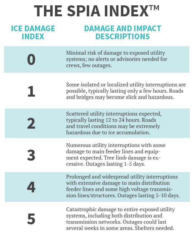
To help prepare for these events, the Sperry Piltz Ice Accumulation Index was created.
22Marlborough Hazard Mitigation Plan Update 2021
Past Events:
November 26, 2014: Snowstorm - New Hampshire, Thanksgiving Storm. The 4th largest power outage
in NH. Some residents lost power for several hours.
January 26-29, 2015: Snowstorm - FEMA Disaster Declaration # DR-4049; $4,939,215. Severe winter
storm and snowstorm. Residents experienced minor power outages. There was no local impact to the Town
other than snow removal.
March 14-15, 2017 - Heavy snow and wind occurred throughout the state. There was no local impact.
March 13-14, 2018 - Heavy snow storm but no local impact. FEMA Disaster Declaration # DR-4371 for
Carroll, Strafford, and Rockingham Counties.
Potential Occurrences:
• This is a town-wide event; therefore, no specific locations are listed, however, roads with moderate
to steep grades are a concern for driver safety.
Potential Impact:
• There is a potential for damage to structures and interruption of service;
• There is a potential for injury or death.
Solar Storm and Space Weather
Risk: High
Impact: Medium
Future probability: High
The term space weather is relatively new and describes the dynamic conditions in the Earth’s outer space
environment, similar to how the terms “climate” and “weather” refer to the conditions in the Earth’s lower
atmosphere. Space weather includes any and all conditions and events on the sun, in the solar wind, in
near-Earth space, and in our upper atmosphere that can affect space-borne and ground based technological
systems.
The table below shows the level of severity of space weather as it relates to the impact on radio
communications. The National Oceanic and Atmospheric Administration (NOAA) uses this table to alert
those who depend on radio communications such as first responders and airlines on days that could create
life threatening situations if their radios are impacted.
23You can also read