National Marine Fisheries Service/Federal Highway Administration Best Management Practices Manual For Transportation Activities in the Greater ...
←
→
Page content transcription
If your browser does not render page correctly, please read the page content below
National Marine Fisheries Service/Federal Highway Administration
Best Management Practices Manual
For Transportation Activities in the Greater Atlantic Region
NMFS/FHWA: BMP Manual for ESA Section 7 and EFH Consultations on Transportation Actions in the Greater Atlantic Region

           NMFS/FHWA Best Management Practices (BMPs) Manual for
              Transportation Actions in the Greater Atlantic Region
                  Prepared in Collaboration through an Interagency Agreement by:

      National Marine Fisheries Service, Greater Atlantic Regional Fisheries Office (GARFO)
                         55 Great Republic Drive, Gloucester, MA 01930

           Integrated Statistics, Information Technology and Environmental Services Specialists
                                  16 Sumner Street, Woods Hole, MA 02543

                                                    With and for:

   Federal Highway Administration, Office of Project Development and Environmental Review
                    1200 New Jersey Avenue SE, Washington, DC 20590

                                                     Assisted by:

      Volpe, The National Transportation Systems Center, U.S. Department of Transportation
                     55 Broadway, Kendall Square, Cambridge, MA 02142

                                                      April 2018

2 | Page
NMFS/FHWA: BMP Manual for ESA Section 7 and EFH Consultations on Transportation Actions in the Greater Atlantic Region

Table of Contents
1.0        Introduction ..................................................................................................................................... 5
2.0        ESA-Listed Species and Critical Habitat in the Greater Atlantic Region ................................. 7
   2.1      Fish................................................................................................................................................... 8
   2.2      Sea Turtles ..................................................................................................................................... 13
   2.3      Whales ........................................................................................................................................... 14
3.0        Essential Fish Habitat (EFH) in the Greater Atlantic Region .................................................. 17
   3.1      EFH Designations for Federally-Managed Species ....................................................................... 18
   3.2      Major Habitat Types ...................................................................................................................... 19
4.0        Stressors and Effects ..................................................................................................................... 22
   4.1      Underwater Noise/Hydroacoustic Energy ..................................................................................... 23
   4.2      Impingement/Entrainment and Entanglement ............................................................................... 27
   4.3      Turbidity and Sedimentation.......................................................................................................... 30
   4.4      Reduced Water Quality (Dissolved oxygen, Temperature, and Pollutants) .................................. 33
   4.5      Habitat Alteration........................................................................................................................... 36
   4.6      Vessel Interaction........................................................................................................................... 41
5.0        Transportation Activities and Sub-Activities ............................................................................. 45
   5.1      Transportation Activity Descriptions ............................................................................................. 46
   5.2      Transportation Sub-Activity Descriptions ..................................................................................... 47
6.0        Best Management Practices (BMPs) ........................................................................................... 50
   6.1      Underwater Noise/Hydroacoustic Energy ..................................................................................... 51
   6.2      Impingement/Entrainment and Entanglement ............................................................................... 52
   6.3      Turbidity and Sedimentation.......................................................................................................... 53
   6.4      Reduced Water Quality .................................................................................................................. 54
   6.5      Habitat Alteration........................................................................................................................... 54
   6.6      Vessel Interaction........................................................................................................................... 57
Literature Cited ........................................................................................................................................ 59
List of Appendices ..................................................................................................................................... 71
   Appendix A. Recommended Time of Year Restrictions for Essential Fish Habitat ............................... 72
   Appendix B. Natural Resources and Habitat Links ................................................................................ 74
   Appendix C. BMP Spreadsheet .............................................................................................................. 76

3 | Page
NMFS/FHWA: BMP Manual for ESA Section 7 and EFH Consultations on Transportation Actions in the Greater Atlantic Region

Tables and Figures
Figure 1. Atlantic Salmon Critical Habitat ................................................................................................. 10
Figure 2. Atlantic Sturgeon Critical Habitat in the GAR ............................................................................ 12
Figure 3. North Atlantic Right Whale Critical Habitat in the GAR............................................................ 16
Table 1. GARFO Sound Thresholds for ESA-Listed Species .................................................................... 25

4 | Page
NMFS/FHWA: BMP Manual for ESA Section 7 and EFH Consultations on Transportation Actions in the Greater Atlantic Region

1.0        Introduction

5 | Page
NMFS/FHWA: BMP Manual for ESA Section 7 and EFH Consultations on Transportation Actions in the Greater Atlantic Region

1.0        Introduction
The Endangered Species Act (ESA), Magnuson-Stevens Fishery Conservation and Management
Act (MSA), and the Fish and Wildlife Coordination Act (FWCA) require federal agencies, such
as the Federal Highway Administration (FHWA) to consult with NOAA’s National Marine
Fisheries Service (NMFS) on actions they fund, permit, or carry out that may adversely affect
ESA-listed species and their critical habitat, essential fish habitat (EFH), and/or other NOAA
trust resources. FHWA and NMFS conduct these consultations to minimize adverse effects from
transportation projects on NOAA trust resources. This Best Management Practices (BMP) 1
Manual provides a summary of the potential adverse effects produced by transportation projects
as well as NMFS’ Greater Atlantic Regional Fisheries Office’s (GARFO) recommended
measures to avoid, minimize, and/or offset those adverse effects.

The guidance in this BMP Manual provides a consistent, biologically driven effects analysis for
the full range of transportation projects affecting ESA-listed species and their critical habitats,
designated EFH, and other NOAA trust resources 2 under NMFS’ jurisdiction in the Greater
Atlantic Region (GAR). GARFO’s jurisdiction includes any coastal or riverine areas where
ESA-listed species, EFH, and/or NOAA trust resources may be present in the GAR. This Manual
is applicable for transportation activities in Maine, New Hampshire, Massachusetts, Rhode
Island, Connecticut, New York, New Jersey, Pennsylvania, Delaware, Maryland, District of
Columbia, and Virginia.

The BMPs provided herein are recommendations for transportation agencies to incorporate into
their projects to avoid, minimize, and offset adverse effects to ESA-listed species and their
critical habitat, EFH, and other NOAA trust resources. The BMPs provide more transparency
and predictability to transportation agencies, including FHWA and state Departments of
Transportation (state DOTs) regarding species conservation, habitat needs, and GARFO’s
recommendations. This conservation strategy facilitates project approvals by enabling
transportation agencies to incorporate impact avoidance and other minimization strategies during
project planning. For transportation activities that cannot fully avoid impacts, project proponents
can incorporate these BMPs in the design or planning phases to minimize impacts and future
redesign of projects. The information in this document may inform transportation agencies of
options to incorporate in design scenarios and alternatives development and in conducting
biological evaluations and assessments. This approach intends to improve predictability, increase
consistency of project design and review, reduce consultation timeframes and delays, and
contribute to the conservation of trust resources, leading to improved environmental outcomes.

1
  This manual uses the term “Best Management Practices (BMPs)” to represent the preferred practices, methods, actions,
materials and other items that avoid and minimize impacts to ESA-listed species and their critical habitat, EFH, and NOAA trust
resources.
2
  Many NOAA trust resources serve as prey for federally-managed species and are therefore a component of EFH.

6 | Page
NMFS/FHWA: BMP Manual for ESA Section 7 and EFH Consultations on Transportation Actions in the Greater Atlantic Region

2.0 ESA-Listed Species and Critical Habitat in the Greater
Atlantic Region

7 | Page
NMFS/FHWA: BMP Manual for ESA Section 7 and EFH Consultations on Transportation Actions in the Greater Atlantic Region

2.0 ESA-Listed Species and Critical Habitat in the Greater
Atlantic Region
The ESA provides protection to species listed as threatened and endangered. In most cases, once
an agency lists a species as threatened or endangered, the agency must also designate critical
habitat. 3 Critical habitat includes areas occupied by the species, in which are found physical and
biological features (PBFs) 4 that are essential to the conservation of an ESA-listed species and
which may require special management considerations or protection. Critical habitat may also
include unoccupied habitat if it is essential for the conservation of the species. Some species are
listed as one unit throughout their range and some species are listed as distinct population
segments (DPSs) with each DPS treated as a separate species. Descriptions of the ESA-listed
species under GARFO jurisdiction are provided below. 5

More detailed information on species biology and site-specific distribution of these species is
provided in NMFS’ species presence tables. 6 These tables provide specific information on
locations of ESA-listed species including seasonality, life stages, and behaviors of the animals in
distinct geographic areas. The GARFO ESA-Listed Species Maps provide a visual overview of
the presence of a particular ESA-listed species using the best available knowledge, geographic
factors, time of year, and the biology of that species. These tools allow for proactive
conservation, prior to conducting ESA consultation. FHWA/state DOTs can use the site-specific
information to inform preparation of a Biological Assessment, and ultimately avoid and
minimize impacts to ESA-listed species by determining why and how stressors affect which
species and connecting that to the appropriate BMPs to minimize their interaction.

2.1        Fish
2.1.1 Atlantic salmon (Salmo salar) – Endangered
NMFS and United States Fish and Wildlife Service (U.S. FWS) (the Services) jointly listed the
Gulf of Maine DPS of anadromous 7 Atlantic salmon as an endangered species on November 17,
2000. In 2009, the Services finalized an expanded listing of Atlantic salmon and its designated
critical habitat (74 FR 29344, June 19, 2009). The current Gulf of Maine DPS includes all
anadromous Atlantic salmon whose freshwater range occurs in the watersheds from the
Androscoggin River northward along the Maine coast to the Dennys River and wherever these
fish occur in estuarine and marine environments. The marine range of Gulf of Maine DPS
extends from the Gulf of Maine, throughout the Northwest Atlantic Ocean, to the coast of

3
  Section 3(5)(A) of the ESA (16 U.S.C. 1532(5)) defines critical habitat as: (i) the specific areas within the geographical area
occupied by the species, at the time it is listed in accordance with the provisions of section 4 of the Act, on which are found those
physical or biological features (I) essential to the conservation of the species and (II) which may require special management
considerations or protection; and (ii) specific areas outside of the geographical area occupied by the species at the time it is listed
in accordance with the provisions of section 4 of the Act, upon a determination by the Secretary that such areas are essential for
the conservation of the species.
4
  “Physical or biological features” are the features that support the life-history needs of the species, including, but not limited to,
water characteristics, soil type, geological features, sites, prey, vegetation, symbiotic species or other features.
5
  This guidance does not address Marine Mammal Protection Act (MMPA) concerns. For impacts to species covered under the
MMPA that are not ESA-listed species, refer to NMFS' website for further information.
6 For actions incorporating this information including species information and BMPs, FHWA/state DOTs should first ensure use

of the most recent version (including any updates to the ESA section 7 maps).
7
  Anadromous fish are a subset of diadromous fish. Anadromous fish live as adults in saltwater and spawn in freshwater.

8 | Page
NMFS/FHWA: BMP Manual for ESA Section 7 and EFH Consultations on Transportation Actions in the Greater Atlantic Region

Greenland. All associated conservation hatchery populations used to supplement these natural
populations are included in the Gulf of Maine DPS; currently, such conservation hatchery
populations are maintained at Green Lake National Fish Hatchery and Craig Brook National Fish
Hatchery, both operated by U.S. FWS. Landlocked Atlantic salmon and salmon raised in
commercial hatcheries for the aquaculture industry are excluded from the Gulf of Maine DPS.

2.1.1.1 Atlantic salmon critical habitat
With the June 19, 2009 endangered listing, the Services designated critical habitat for the Gulf of
Maine DPS of Atlantic salmon. The Services revised the final rule on August 10, 2009 (74 FR
39003). In this revision, designated critical habitat for the expanded Gulf of Maine DPS of
Atlantic salmon was updated to exclude trust and fee holdings of the Penobscot Indian Nation.
The final rule identified 45 specific areas containing over 19,000 kilometers of rivers and
streams and 799 square kilometers of lakes and ponds as having the PBFs essential to the
conservation of the species, which may require special management or protections.

Within the occupied range of the Gulf of Maine DPS, Atlantic salmon PBFs include sites for
spawning and incubation, sites for juvenile rearing, and sites for migration. The PBFs that allow
these sites to be used successfully for spawning, incubation, rearing, and migration are the
features of habitat within the Gulf of Maine DPS that are essential to the conservation of the
species. Kircheis and Liebich (2007) provide a detailed review of the PBFs Atlantic salmon
require. GIS layers for Atlantic salmon critical habitat are available at NMFS’ Geographic
Information System website. Atlantic salmon is unique because in addition to having populations
listed as endangered, it also has designated EFH. Atlantic salmon critical habitat and EFH may
overlap in some areas.

9 | Page
NMFS/FHWA: BMP Manual for ESA Section 7 and EFH Consultations on Transportation Actions in the Greater Atlantic Region

Figure 1. Atlantic Salmon Critical Habitat

2.1.2 Atlantic sturgeon (Acipenser oxyrinchus oxyrinchus) – Endangered and
Threatened
     •      Gulf of Maine DPS – Threatened
     •      New York Bight DPS – Endangered
     •      Chesapeake Bay DPS – Endangered
     •      Carolina DPS – Endangered
     •      South Atlantic DPS – Endangered

On February 6, 2012, NMFS listed four DPSs of Atlantic sturgeon as endangered (New York
Bight, Chesapeake Bay, Carolina, and South Atlantic) and one DPS as threatened (Gulf of
Maine) under the ESA (77 FR 5880 and 77 FR 5914). The marine range for all five DPSs
includes all marine waters, coastal bays and estuaries, from Labrador Inlet, Labrador, Canada to
Cape Canaveral, Florida. The ranges of all five DPSs overlap. Based on the best available
information on the distribution of Atlantic sturgeon, NMFS determined that Atlantic sturgeon
from any of the five DPSs may be present in the GAR. Atlantic sturgeon migrate into the ocean
from the river they were born, at two or three years old (“subadults”); they occur along the U.S.
Atlantic coast using rivers and estuaries. Spawning most often occurs in late spring or early

10 | Page
NMFS/FHWA: BMP Manual for ESA Section 7 and EFH Consultations on Transportation Actions in the Greater Atlantic Region
summer (April to June), and fall spawning occurs in some rivers (e.g., James and York Rivers).
Spawning typically occurs in flowing water between the salt front and fall line of large rivers.
2.1.2.1. Atlantic sturgeon critical habitat
NMFS issued two proposed rules to designate critical habitat for the five listed DPSs of Atlantic
sturgeon in U.S. waters: 1) Gulf of Maine, New York Bight, and Chesapeake Bay DPSs (81 FR
35701; June 3, 2016); and 2) Carolina and South Atlantic DPSs (81 FR 41926; June 28, 2016).
On August 17, 2017, NMFS published one final rule designating critical habitat for all five
DPSs. The effective date of the rule is September 18, 2017. The final rule identifies four PBFs
necessary for the conservation of the species:
1. Hard bottom substrate (e.g., rock, cobble, gravel, limestone, boulder, etc.) in low salinity
waters (i.e., 0.0 to 0.5 parts per thousand (ppt) range) for settlement of fertilized eggs,
refuge, growth, and development of early life stages;
2. Aquatic habitat with a gradual downstream salinity gradient of 0.5 up to as high as 30 ppt
and soft substrate (e.g., sand, mud) between the river mouth and spawning sites for
juvenile foraging and physiological development;
3. Water of appropriate depth and absent physical barriers to passage (e.g., locks, dams,
thermal plumes, turbidity, sound, reservoirs, gear, etc.) between the river mouth and
spawning sites necessary to support: 1) unimpeded movement of adults to and from
spawning sites; 2) seasonal and physiologically dependent movement of juvenile Atlantic
sturgeon to appropriate salinity zones within the river estuary; and 3) staging, resting, or
holding of subadults or spawning condition adults. Water depths in main river channels
must also be deep enough (e.g., at least 1.2 m) to ensure continuous flow in the main
channel at all times when any sturgeon life stage would be in the river; and
4. Water, between the river mouth and spawning sites, especially in the bottom meter of the
water column, with the temperature, salinity, and oxygen values that, combined, support:
1) spawning; 2) annual and inter-annual adult, subadult, larval, and juvenile survival; and
3) larval, juvenile, and subadult growth, development, and recruitment (e.g., 13°C to
26°C for spawning habitat and no more than 30°C for juvenile rearing habitat, and 6
milligrams per liter (mg/L) dissolved oxygen (DO) or greater for juvenile rearing
habitat).
In the GAR, critical habitat for Atlantic sturgeon is located within the following river systems: 1)
Penobscot, 2) Kennebec, 3) Androscoggin, 4) Piscataqua, 5) Merrimack, 6) Connecticut, 7)
Housatonic, 8) Hudson, 9) Delaware, 10) Nanticoke, 11) Marshyhope Creek, 12) Potomac, 12)
Rappahannock, 13) York/Mattaponi/Pamunkey, and 14) James. The habitat containing the
physical features essential to the conservation of the Gulf of Maine, New York Bight, and
Chesapeake Bay DPSs and that may require special management or protection is aquatic habitat
of main stem rivers flowing into a coastal estuary. Atlantic sturgeon typically cannot pass dams
or natural features such as waterfalls and rapids found at the fall line of rivers in the GAR.
Therefore, NMFS defined each critical habitat unit for these three DPSs by an upriver landmark
on the main stem river (e.g., the most downriver dam or a bridge immediately downriver of the
fall line of that river) and all waters of the main stem downriver of that landmark to where the
waters empty at its mouth into an identified water body (82 FR 39160).
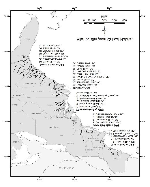
11 | PageNMFS/FHWA: BMP Manual for ESA Section 7 and EFH Consultations on Transportation Actions in the Greater Atlantic Region Figure 2. Atlantic Sturgeon Critical Habitat in the GAR 2.1.3 Shortnose sturgeon (Acipenser brevirostrum) – Endangered Shortnose sturgeon are listed as endangered by NMFS (32 FR 4001, March 11, 1967). Shortnose sturgeon occur in most major Atlantic river systems from the Minas Basin in Nova Scotia, Canada, to the St. Johns River, Florida. Spawning populations have been documented in the following large coastal river systems: the Penobscot, Kennebec, Androscoggin, Merrimack, Connecticut, Hudson, Delaware, and Potomac Rivers. Unlike adult Atlantic sturgeon that range widely along the coast, most adult shortnose sturgeon remain in their natal river or estuary. While movements between river systems have been documented in the Gulf of Maine, between 12 | Page
NMFS/FHWA: BMP Manual for ESA Section 7 and EFH Consultations on Transportation Actions in the Greater Atlantic Region

the Connecticut and Hudson Rivers, and in the Southeast, interbreeding between river
populations is limited to very few individuals per generation; this results in morphological and
genetic variation between most river populations (Walsh et al. 2001; Grunwald et al. 2002;
Waldman et al. 2002; Wirgin et al. 2005). Many of the river systems within the range are
considerable separated, while others are geographically close and sometimes share a river mouth
or estuary.

2.2         Sea Turtles
      •     North Atlantic DPS of green sea turtles – Threatened
      •     Kemp’s ridley sea turtles – Endangered
      •     Leatherback sea turtles– Endangered
      •     Northwest Atlantic DPS of loggerhead sea turtles – Threatened

All four species of sea turtles are highly migratory and travel widely throughout the GAR. While
sea turtles may occur year-round off the southeastern U.S., they are generally present in marine
and estuarine waters of the GAR from May through November. As water temperatures rise in the
spring, sea turtles begin to migrate to nearshore waters and up the U.S. Atlantic coast, occurring
in Virginia as early as April/May and in the Gulf of Maine in June. The trend is reversed in the
fall with some animals remaining in the GAR until late fall. Nesting is extremely limited in the
region; typically, juveniles and, to a lesser extent, adults are present in the GAR.

2.2.1 North Atlantic DPS of green sea turtle (Chelonia mydas) – Threatened
On April 6, 2016, NMFS and the U.S. Fish and Wildlife Service issued a final rule to list 11
DPSs of the green sea turtle under the ESA (81 FR 20057). The final rule became effective on
May 6, 2016. Based on the best available scientific and commercial data, and after considering
comments on the proposed rule, the Services listed three DPSs as endangered and eight DPSs as
threatened. The North Atlantic DPS, the only DPS of green sea turtles found in the GAR, is
listed as threatened. In the U.S. Atlantic Ocean, green sea turtles are occasionally found as far
north as New England, but are more commonly seen from New York south. They occur
seasonally in GAR waters, including but not limited to Chesapeake Bay and Long Island Sound,
which serve as foraging and developmental habitats.

2.2.2 Kemp’s ridley sea turtle (Lepidochelys kempii) – Endangered
The Kemp’s ridley turtle was first listed under the Endangered Species Conservation Act of 1970
on December 2, 1970 (35 FR 18319), and subsequently under the ESA. On March 23, 1999,
NMFS revised and consolidated the initial regulation (64 FR 14052). The endangered Kemp’s
ridley sea turtle is one of the least abundant of the world’s sea turtle species. In contrast to
loggerhead, leatherback, and green sea turtles, which inhabit multiple oceans of the world,
Kemp’s ridley sea turtles typically occur only in the Gulf of Mexico and the northwestern waters
of the Atlantic Ocean. Adult Kemp’s ridley sea turtles are rare in the northeastern U.S. waters of
the Atlantic, although juveniles venture as far north as New England, as demonstrated by the
cold stunning events that occur in Cape Cod Bay each fall when temperatures drop. Foraging
areas in the GAR include, but are not limited to, Chesapeake Bay, Delaware Bay, Cape Cod Bay,
and Long Island Sound.

13 | Page
NMFS/FHWA: BMP Manual for ESA Section 7 and EFH Consultations on Transportation Actions in the Greater Atlantic Region
2.2.3 Leatherback sea turtle (Dermochelys coriacea) – Endangered
Leatherback sea turtles, listed as endangered (35 FR 8491, June 2, 1970), are the largest living
turtles, and range farther than any other sea turtle species. Leatherback sea turtles are a pelagic
species that feed on jellyfish and tunicates; however, they use coastal waters of the U.S.
continental shelf on a seasonal basis. Their large size and tolerance of relatively low water
temperatures allow them to occur in boreal waters such as those off Labrador. The distribution of
the leatherback sea turtle includes the Gulf of Maine northward to Nova Scotia and the Labrador
coast during the summer and late summer months. Leatherbacks aggregate in and at the mouth of
Chesapeake Bay during warmer months, presumably taking advantage of large jellyfish
populations that breed in the bay.
2.2.4 Northwest Atlantic DPS of loggerhead sea turtle (Caretta caretta) – Threatened
The Northwest Atlantic DPS of loggerhead sea turtles is listed as threatened (76 FR 58868,
September 22, 2011) and is the most abundant species of sea turtle in U.S. waters. They are
found in temperate and subtropical waters and occupy a range of habitats including offshore
waters, continental shelves, bays, estuaries, and lagoons. Loggerhead sea turtles occur year-
round in ocean waters of the South Atlantic Bight where water temperature is influenced by the
proximity of the Gulf Stream. As coastal water temperatures warm in the spring, loggerheads
begin to migrate to inshore waters of the southeast U.S. and also move up the U.S. Atlantic coast,
occurring in Virginia foraging areas as early as April/May and on the most northern foraging
grounds in the Gulf of Maine in June. The trend is reversed in the fall as water temperatures cool.
Most loggerheads leave the Gulf of Maine by mid-September, but some may remain in the Mid-
Atlantic and Northeast until late fall.
2.2.4.1 Northwest Atlantic DPS of loggerhead sea turtle critical habitat
On July 10, 2014, the Services published two separate final rules designating critical habitat for
the Northwest Atlantic DPS of loggerhead sea turtles (79 FR 39755 for nesting beaches under
U.S. FWS jurisdiction; 79 FR 39856 for marine areas under NMFS’ jurisdiction). Effective
August 11, 2014, NMFS’ final rule for marine areas designated 38 occupied areas within the at-
sea range of the Northwest Atlantic DPS. These designated marine areas of critical habitat
contain one or more of the following habitats: nearshore reproductive habitat, overwintering
habitat, breeding habitat, migratory habitat, and Sargassum habitat. In the GAR, the only critical
habitat for loggerheads is Sargassum habitat which occurs far offshore (beyond the continental
shelf break) of the Delmarva Peninsula.
2.3 Whales
• North Atlantic right whale – Endangered
• Fin whale – Endangered
• Sei whale – Endangered
• Sperm whale – Endangered
• Blue whale – Endangered
Right and fin whales occur in Mid-Atlantic and New England waters over the continental shelf.
In general, these two species follow a similar pattern of foraging at high latitudes (e.g., New
England and Canadian waters) in the spring and summer months and calving in lower latitudes
14 | PageNMFS/FHWA: BMP Manual for ESA Section 7 and EFH Consultations on Transportation Actions in the Greater Atlantic Region
(i.e., off of Florida for right whales) in the winter months. These species make rare appearances
in bays and estuaries of the GAR; their presence is typically restricted to offshore waters. Sei,
sperm, and blue whales typically occur in deeper waters beyond the continental shelf and are rare
within state waters where most FHWA transportation activities occur. As a result, this Manual
does not discuss them in detail.
2.3.1 North Atlantic right whale (Eubalaena glacialis) – Endangered
Northern right whales were originally listed December 2, 1970 (35 FR 18319) and the North
Atlantic right whale was subsequently listed as a separate species (73 FR 12024, March 6, 2008).
North Atlantic right whales are the most endangered large whale species in the GAR. The
population ranges primarily from calving grounds in coastal waters of the southeastern U.S. to
feeding grounds in New England waters and the Canadian Bay of Fundy, Scotian Shelf, and Gulf
of St. Lawrence. The distribution of right whales seems linked to the distribution of their
principal zooplankton prey, calanoid copepods. Right whales are most abundant in Cape Cod
Bay between February and April and in the Great South Channel in May and June where they are
observed feeding predominantly on copepods of the genera Calanus and Pseudocalanus. Right
whales also frequent Stellwagen Bank and Jeffreys Ledge, as well as Canadian waters including
the Bay of Fundy, and Browns and Baccaro Banks in summer through fall.
2.3.1.1 North Atlantic right whale critical habitat
On January 27, 2016, NMFS published a final rule (81 FR 4837) to replace the critical habitat for
right whales in the North Atlantic, originally designated in 1994, with two new areas. The
effective date for this final rule is February 26, 2016. The areas designated as critical habitat
contain approximately 29,763 square nautical miles of marine habitat in the Gulf of Maine and
Georges Bank region (Unit 1, Northeastern U.S. Foraging Area) and off the Southeast U.S. coast
(Unit 2, Southeastern U.S. Calving Area). GIS layers for right whale critical habitat are available
on the NMFS GIS website. The final rule identifies the following four PBFs of the Northeastern
U.S. foraging habitat that are essential to conservation of the species:
1. The physical oceanographic conditions and structures of the Gulf of Maine and Georges
Bank region that combine to distribute and aggregate Calanus finmarchicus for right
whale foraging, namely prevailing currents and circulation patterns, bathymetric features
(basins, banks, and channels), oceanic fronts, density gradients, and temperature regimes;
2. Low flow velocities in Jordan, Wilkinson, and Georges Basins that allow diapausing C.
finmarchicus to aggregate passively below the convective layer so that the copepods are
retained in the basins;
3. Late stage C. finmarchicus in dense aggregations in the Gulf of Maine and Georges Bank
region; and
4. Diapausing C. finmarchicus in aggregations in the Gulf of Maine and Georges Bank
region.
15 | PageNMFS/FHWA: BMP Manual for ESA Section 7 and EFH Consultations on Transportation Actions in the Greater Atlantic Region Figure 3. North Atlantic Right Whale Critical Habitat in the GAR 2.3.2 Fin whale (Balaenoptera physalus) – Endangered Fin whales were listed as endangered on December 2, 1970 (35 FR 18319) and are common in waters of the U.S. Atlantic from Cape Hatteras northward. Fin whales are migratory, moving seasonally into and out of high-latitude feeding areas, but the overall migration pattern is complex and specific routes are not documented. However, acoustic recordings from passive- listening hydrophone arrays indicate that a southward “flow pattern” occurs in the fall from the Labrador-Newfoundland region, past Bermuda, and into the West Indies. The most important area for this species on the Northeast U.S. continental shelf appears to be from the Great South Channel, along the 50-meter isobath past Cape Cod, over Stellwagen Bank, and past Cape Ann to Jeffreys Ledge. 16 | Page
NMFS/FHWA: BMP Manual for ESA Section 7 and EFH Consultations on Transportation Actions in the Greater Atlantic Region

3.0         Essential Fish Habitat (EFH) in the Greater Atlantic Region

17 | Page
NMFS/FHWA: BMP Manual for ESA Section 7 and EFH Consultations on Transportation Actions in the Greater Atlantic Region

3.0         Essential Fish Habitat (EFH) in the Greater Atlantic Region
Habitat has an essential role in supporting the productivity of a species. EFH includes all types of
aquatic habitat where fish spawn, breed, feed, or grow to maturity. Such habitats include, but are
not limited to, wetlands, mudflats, seagrasses, sand, cobble, bays, rivers, and estuaries. In the
GAR, NMFS and the New England, Mid-Atlantic, and South Atlantic fishery management
councils (FMCs) identify and designate EFH for life stages of each federally-managed species
and habitat areas of particular concern (HAPCs) using the best available scientific information.
HAPCs are high priority areas for conservation, management, or research because they are rare,
sensitive, stressed by development, or important to ecosystem function.

3.1         EFH Designations for Federally-Managed Species
The official EFH designation language for federally-managed species in the GAR, including text
descriptions and information on life history stages and habitat preferences for each species, is
provided in the Guide to Essential Fish Habitat Designations in the Northeastern United States. 8
The designations describe the geographic extent in which EFH is found and the type of habitats
used by each life stage. The Essential Fish Habitat Mapper provides a spatial representation of
EFH and HAPCs by species and life stage.

In the GAR, EFH is designated for the following species:

American plaice, Atlantic cod, Atlantic halibut, Atlantic herring, Atlantic mackerel, Atlantic
salmon, Atlantic sea scallop, Atlantic wolffish, black sea bass, bluefish, butterfish, cobia, golden
crab, haddock, king mackerel, longfin squid, monkfish, ocean pout, ocean quahog, offshore hake,
pollock, red hake, redfish, scup, shortfin squid, skates (barndoor, clearnose, little, rosette,
smooth, thorny, winter), Spanish mackerel, spiny dogfish, summer flounder, surf clam, tilefish,
white hake, whiting, windowpane flounder, winter flounder, witch flounder, and yellowtail
flounder.

EFH is also designated for the following highly migratory species and billfish in the GAR:

Albacore tuna, Atlantic angel shark, Atlantic bigeye tuna, Atlantic bluefin tuna, Atlantic
sharpnose, Atlantic skipjack tuna, Atlantic swordfish, Atlantic yellowfin tuna, basking shark,
bigeye thresher shark, blue marlin, blue shark, common thresher shark, dusky shark, longbill
spearfish, longfin mako shark, porbeagle shark, roundscale spearfish, sand tiger shark, sandbar
shark, scalloped hammerhead shark, shortfin mako shark, silky shark, smooth dogfish, tiger
shark, white marlin, and white shark.

3.1.1 Habitat Areas of Particular Concern (HAPCs)
HAPCs are a subset of EFH and are depicted on the EFH Mapper. In the GAR, HAPCs include:

      1. Juvenile Atlantic cod: an area on Georges Bank of approximately 300 square nautical
         miles along the northern edge of Georges Bank and the Hague Line containing gravel
         cobble substrate;
8
 Note that the description of EFH in the fishery management plans takes precedence over any information on the website and the
EFH mapper.

18 | Page
NMFS/FHWA: BMP Manual for ESA Section 7 and EFH Consultations on Transportation Actions in the Greater Atlantic Region
2. Adult Atlantic salmon: 11 rivers in Maine (Dennys, Machias, East Machias, Pleasant,
Narraguagus, Ducktrap, Kennebec, Penobscot, St. Croix, Tunk Stream, and Sheepscot);
3. Summer flounder: all native species of macroalgae, seagrasses, and freshwater and tidal
macrophytes in any size bed, as well as loose aggregations within adult and juvenile
summer flounder EFH; 9
4. Tilefish: substrate between the 250- and 1200-foot isobath, adjacent to Veatch,
Oceanographer, and Lydonia Canyons; and
5. Sandbar shark: areas at the mouth of Great Bay, NJ, in Delaware Bay, and lower
Chesapeake Bay.
3.2 Major Habitat Types
The aquatic habitats in the GAR contain varying physical and biological properties from the cold
waters of the Gulf of Maine south to the more temperate climate of the Mid-Atlantic Bight. In
this region, the oceanographic and physical processes interact to form a network of expansively
to narrowly distributed habitat types (Stevenson et al. 2004). The GAR contains freshwater
rivers and streams that flow towards the sea into numerous bays and estuaries that serve as
important refuge and nursery areas for marine species. The major systems include riverine/
freshwater, estuarine/nearshore, and marine/offshore environments. FHWA/state DOT’s
transportation activities that affect aquatic resources are generally limited to riverine and
estuarine locations. Some of the diadromous 10 fish in the GAR include striped bass, alewife,
blueback herring, American shad, and American eel. Other NOAA trust resources, including
American lobster, blue crab, black sea bass, cunner, tautog, mummichog, and silversides,
provide valuable recreational and commercial fisheries and are critical to a healthy marine
ecosystem. Many of these species serve as the forage base for federally-managed fisheries, and
are a component of EFH. SAV and shellfish maps may be available from state environmental
agencies. A list of some electronic sources of this information is provided in Appendix B.
3.2.1 Riverine/Freshwater
Riverine and riparian habitats in the northeastern coastal U.S. are important for the growth,
survival, and reproduction of diadromous fish and are critical to maintaining healthy estuarine
ecosystems. These habitats include freshwater streams, rivers, streamside wetlands, freshwater
submerged aquatic vegetation (SAV), and banks and associated vegetation bordered by other
freshwater habitats (NEFMC 1998). Depending on water velocity and other physical
characteristics, riverine systems include benthic substrates ranging from exposed bedrock,
cobble, and other hard bottom types to extremely unconsolidated, soft materials. These features
largely determine the fish and invertebrates present.
Free flowing waters act as migratory corridors and spawning, nursery, and rearing areas and
provide forage and refuge for different life stages of fish. Riparian corridors provide shade,
nutrients, and habitat-enhancing debris in riverine systems (Bilby and Ward 1991), which are
essential elements for these aquatic resources to thrive. Freshwater wetlands and SAV perform
important ecological functions by reducing erosion, attenuating floodwater velocity and volume,
9 The EFH mapper does not show these areas. You may find SAV maps in the links in Appendix B or you may need to collect
site-specific data to identify this HAPC.
10 Diadromous fish are those that spend part of their lives in saltwater and part in freshwater.
19 | PageNMFS/FHWA: BMP Manual for ESA Section 7 and EFH Consultations on Transportation Actions in the Greater Atlantic Region improving water quality by the uptake of nutrients, and reducing sediment loads (Howard- Williams 1985; De Laney 1995; Fletcher 2003). Freshwater habitats are vulnerable to anthropogenic disturbances that alter the functions, values, quantity, and accessibility of freshwater wetlands used by diadromous fish (Beschta et al. 1987; Naiman 1992). 3.2.2 Estuarine/Nearshore Estuaries are bays and inlets influenced by oceans and rivers, serving as the transition zone between fresh and salt water. In the northeastern U.S., estuaries include inland reaches of large river systems where salinities exceed 0.5 ppt. They support communities of plants and animals adapted to the mixing zone. These habitats support reproduction, feeding, refuge, and other physiological necessities (NEFMC 1998). Coastal and estuarine features such as salt marshes, mud flats, rocky intertidal zones, sandy beaches, and SAV are critical to nearshore and offshore habitats and fishery resources of the northeastern U.S. (Stevenson et al. 2004; Kritzer et al. 2016). Nearshore habitats are dynamic environments that support most marine and diadromous fish at some stage of development (NEFMC 1998). Mud flats, salt marshes, and creeks provide productive shallow water habitat for forage species. These valuable habitats are some of the most vulnerable to alterations through coastal development, including transportation actions. Shallow estuarine waters provide refuge from predation and foraging areas for juvenile fish during high tides (Helfman et al. 2009). Each shallow water habitat type provides EFH for multiple federally-managed fish species. SAV beds are highly productive, produce a structural matrix on which many other species depend, improve water quality, and stabilize sediments (Fonseca et al. 1998). Larvae and juveniles of commercial and sport fish such as bluefish, summer flounder, spot, Atlantic croaker, and herring appear in SAV beds in the spring and early summer (Fonseca et al. 1992). Mud and sand substrates serve as EFH during spawning, juvenile and/or adult stages for species, including, but not limited to, juvenile pollock, juvenile little skate, juvenile hake species, juvenile and adult windowpane flounder, and all life stages of winter flounder (Cargnelli et al. 1999; Chang et al. 1999; Pereira et al. 1999; Stevenson et al. 2014). Mixed gravel substrate habitats provide structural complexity for managed fish species that require shelter and seek refuge from predation, including, but not limited to, juvenile stages of cod, ocean pout, and Atlantic herring (Auster 1998; Auster and Langton 1999; NRC 2002; Stevenson et al. 2006 and 2014). The structural complexity of rocky substrates with attached macroalgae and macrofauna mediate the spatial distribution of juvenile cod and provide additional refuge from predation, significantly increasing their survival (Fraser et al. 1996; Gotceitas et al. 1997; Lindholm et al. 1999 and 2001). 3.2.3 Marine/Offshore The Northeast U.S. Continental Shelf Ecosystem (Sherman et al. 1996) is composed of four distinct sub-regions: the Gulf of Maine, Georges Bank, the Mid-Atlantic Bight, and the continental slope (Stevenson et al. 2004). The Gulf of Maine is an enclosed coastal sea, with relatively cold waters and deep basins with various sediment types. Georges Bank is a relatively shallow coastal plateau that slopes gently from north to south with steep submarine canyons on its eastern and southeastern edge. It contains highly productive, well-mixed waters and strong currents. The Mid-Atlantic Bight contains sandy, relatively flat, gently sloping continental shelf habitat from southern New England to Cape Hatteras, North Carolina. The continental slope is 20 | Page
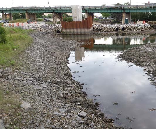
NMFS/FHWA: BMP Manual for ESA Section 7 and EFH Consultations on Transportation Actions in the Greater Atlantic Region

homogenous, with exceptions at the shelf break, some of the canyons, the Hudson Shelf Valley,
and areas of hard bottom (Stevenson et al. 2004). Offshore benthic habitat features include sand
waves, shell aggregates, gravel beds, boulder reefs, and submerged canyons, which provide
nursery areas for many fish species (NEFMC 1998). Many marine organisms inhabit the stable
offshore environment for multiple stages of their life history. It is unlikely that transportation
activities under the purview of this manual would occur in or directly affect these
marine/offshore habitats.

21 | Page
NMFS/FHWA: BMP Manual for ESA Section 7 and EFH Consultations on Transportation Actions in the Greater Atlantic Region

4.0         Stressors and Effects

22 | Page
NMFS/FHWA: BMP Manual for ESA Section 7 and EFH Consultations on Transportation Actions in the Greater Atlantic Region

4.0         Stressors and Effects
Stressors produced by transportation activities may affect ESA-listed species and their critical
habitat, EFH, and other NOAA trust resources. An ESA-listed species may be adversely affected
if it is exposed to any potentially harmful elements of an action or if actions diminish the value
of critical habitat. An adverse effect on EFH is any impact that reduces the quality and/or
quantity of EFH and may include direct or indirect physical, chemical, or biological alterations
of the waters or substrate and loss of, or injury to, benthic organisms, prey species and their
habitat, and other ecosystem components. Transportation activities occurring within or adjacent
to aquatic areas can cause site-specific or habitat-wide adverse effects, including individual,
cumulative, or synergistic consequences of actions. Transportation activities could have positive
effects on ESA-listed species and their critical habitat, EFH, and NOAA trust resources either by
design or coincidentally. For example, upgrading a culvert with a larger diameter opening could
result in better environmental outcomes than replacement in-kind. However, temporary adverse
effects from construction itself and adverse effects from the presence of any structure would
result regardless of any minimization measures used.

This section provides detailed information on how transportation actions create stressors and
how those stressors affect ESA-listed species and their critical habitat, EFH, and other NOAA
trust resources. FHWA/state DOTs can use this information to develop biological
evaluations/assessments and EFH assessments. Aspects of transportation actions can have
complex interrelated effects. Effects can cascade through a system, and the responses by
individuals and populations can vary. For example, while excavation for the installation of
bridge abutments can cause increased turbidity, measures to contain those sediments can create a
barrier to fish. All of the stressors presented here are also considered habitat alteration; however,
the stressors were divided to best reflect the mechanism leading to the effect. The BMPs
provided in Section 6.0 of this guidance include measures to minimize these stressors or
minimize exposure of species and habitat to these stressors. To avoid interactions with ESA-
listed species and their critical habitat and EFH altogether, refer to the ESA tables for
information on spawning areas and other important habitats and the EFH Mapper for spatial data
on EFH and HAPCs by species and life stage.

4.1         Underwater Noise/Hydroacoustic Energy
Transportation activities involving in-water work may produce underwater noise and acoustic
impacts. The duration of acoustic impacts is typically limited to the construction phases.
Demolition may introduce significant acoustic impacts to the aquatic environment. Blasting
represents a single point of disturbance with a restricted, and often predictable, mortality zone.
Blast energy is generally focused towards fracturing rock substrate, preventing excess energy
from releasing into the water column (Keevin et al. 1999). Baker (2008) describes how
detonations in open water produce both higher amplitude and higher frequency shock waves than
contained detonations; thus, the use of stemming charges results in reduced pressures and lower
aquatic organism mortality compared with an equivalent explosive charge weight detonated in
open water (Nedwell and Thandavamoorthy 1992; Hempen et al. 2007).

Unlike blasting, pile driving and mechanical demolition create repeating sound disturbances that
can last for extended periods of time. Factors that affect the type and intensity of sound pressure

23 | Page
NMFS/FHWA: BMP Manual for ESA Section 7 and EFH Consultations on Transportation Actions in the Greater Atlantic Region

waves include the size and type of pile or material, firmness of the substrate, and the type of
equipment/hammer used (Hanson et al. 2003; Johnson et al. 2008). Wood and concrete piles
produce lower sound pressures than do steel piles. Pile driving in firmer substrates requires more
energy and produces more intense sound pressures (Hanson et al. 2003; Johnson et al. 2008).
The intensity of an acoustic pressure wave decreases as it moves away from the source. Sound
propagation is affected by various factors such as water depth, bathymetry, currents, and
substrate type.

Dredging and disposal can produce continuous noise impacts for extended periods of time
(Nightingale and Simenstad 2001b). The acoustic frequencies and sound attenuation depend on
the type of equipment used, the depth and thermal variations in the surrounding water,
bathymetry, and sediment composition (Nightingale and Simenstad 2001b; Stocker 2002).
Mechanical and hydraulic dredges produce underwater sounds that are strongest at low
frequencies and because of rapid attenuation of low frequencies in shallow water, dredge noise
normally is undetectable underwater at ranges beyond 20 to 25 kilometers (Richardson et al.
1995). Although the noise levels from large vessels may exceed those from dredging, single
vessels usually do not produce strong noise in one area for a prolonged period of time
(Richardson et al. 1995). Vessel noise may reverberate or scatter off geological features and
anthropogenic structures in the water (Stocker 2002).

4.1.1 Effects
In addition to physiological effects, underwater noise can interrupt migrating, foraging,
overwintering/ sheltering, or spawning by ESA-listed species, managed species, and/or forage
species such as diadromous fish. This can temporarily cause aquatic organisms to avoid an area
that would normally serve as foraging, spawning, nursery, or refuge habitat. Interruption of basic
biological life stages could have cascading effects by reducing population levels or viability.

4.1.1.1 ESA-listed species
Effects to ESA-listed species may include behavioral modifications, such as avoidance or
decreased foraging activity, injury (e.g., hearing loss), or in extreme cases, mortality, depending
on the distance from the activity. Injury can occur from a single noise event exceeding the
threshold for direct physical injury, constituting an immediate adverse effect; or from prolonged
exposure to noise levels that exceed the daily cumulative exposure threshold, constituting
adverse effects if the species are exposed to the noise levels for prolonged periods. The noise
could deter ESA-listed species from an area, and these behavioral effects can prevent the species
from migrating, foraging, sheltering, or spawning. Pressure oscillations created by blasting cause
a rapid contraction and over-extension of gas-filled cavities (e.g., swim bladders and lungs)
which may result in internal damage or mortality (Wiley et al. 1981).

24 | Page
NMFS/FHWA: BMP Manual for ESA Section 7 and EFH Consultations on Transportation Actions in the Greater Atlantic Region

Table 1. GARFO Sound Thresholds for ESA-Listed Species
      Species Classification            Size          Injury Threshold            Behavioral Modification Threshold

               FISH                     > 2g       206 dBpeak/187 cSEL 11                  150 dB re 1 µPa RMS

                                        < 2g        206 dBpeak/183 cSEL                    150 dB re 1 µPa RMS

            SEA TURTLES                  all        180 dB re 1µPa RMS                     166 dB re 1 µPa RMS

             WHALES                      all             See below 12

                 Impulsive noise
                                                                                             160 re 1µPa RMS

                 Non-pulse noise
                                                                                             120 re 1µPa RMS

4.1.1.1.1 ESA-listed fish
Sound waves can cause temporary or permanent damage to hearing and swim bladders of ESA-
listed fish. Sturgeon and salmon exposed to elevated levels of underwater noise can experience
injury or behavioral disturbance. A conservative indicator of the noise level at which there is the
potential for behavioral effects to ESA-listed fish is 150 decibels relative to one micro-Pascal
(dB re 1 µPa) root-mean-square (RMS). Upon exposure to noise at this level, there is the
potential to experience some behavioral response. Behavioral responses could range from a
temporary startle to avoidance of an ensonified area; fish may leave an area for more suitable
spawning grounds or avoid natural migration paths. Pile-driving operations may affect the
distribution and behavior of juvenile pink salmon and chum salmon (Feist et al. 1996).

At ranges beyond those causing injury, ESA-listed fish are susceptible to behavioral disturbances
from underwater noise in the frequencies of their hearing range. Explosions produce loud,
broadband noise audible to many species, but the main frequencies produced are often influenced
by the blasted material and blasting technique. Based on the duration of noise, repeated exposure
to acoustic energy (e.g., pile driving, dredging, and vessel noise) could result in a wider range of
behavioral effects than single, impulsive energy waves. Project areas in or near known spawning
grounds, important foraging areas, migration corridors, or designated critical habitat may be
more likely to disturb ESA-listed species, depending on when the action occurs (Baker 2008).

Fish with swim bladders, such as salmon and sturgeon, are generally more susceptible to
mortality and injury from explosions than sea turtles and whales, as they are difficult to see from
above the surface of the water and due to their relatively greater numbers and physiological
differences. Fish with swim bladders are more likely to be killed or injured than fish without
swim bladders, as mortality from explosions usually results from tissue damage to gas filled
organs, such as the intestinal tract and swim bladders. Internal injuries to other organ systems

11 The sound exposure level (SEL) is defined as that level which, lasting for one second, has the same acoustic energy as the
transient and is expressed as dB re: 1μPa2•sec.
12
   Please refer to NMFS’ 2016 Marine Mammal Acoustic Technical Guidance document and user spreadsheet for assessing
whether a project creates underwater noise that exceeds the permanent threshold shift (PTS) (i.e., considered injury) or temporary
threshold shift (TTS) limits for listed cetaceans.

25 | Page
NMFS/FHWA: BMP Manual for ESA Section 7 and EFH Consultations on Transportation Actions in the Greater Atlantic Region have occurred from the rapid expansion of the swim bladder resulting from exposure to negative pressures from a shock wave. Smaller fish may incur greater blast injury than larger fish at the same exposure level (Yelverton et al. 1975; Goertner 1978; Wiley et al. 1981; O’Keefe 1984; Munday et al. 1986; Moser 1999; Baker 2008). 4.1.1.1.2 Sea turtles Sound waves can cause temporary or permanent damage to hearing and the lungs of sea turtles. The sea turtle ear appears to be adapted to both aerial and aquatic environments (Baker 2008). Currently, there are no established thresholds for injury or behavioral disturbance for sea turtles. Behavioral reactions of sea turtles (McCauley et al. 2000a and 2000b; DeRuiter and Doukara 2012) were reported for sea turtles in response to airgun noise. McCauley et al. (2000b) noted that decibel levels of 166 dB re 1µPa RMS were required before behavioral reactions (e.g., increased swimming speed) were observed in sea turtles. Based on this, sea turtles exposed to underwater noise greater than 166 dB re 1µPa RMS may be expected to experience behavioral disturbance and actively avoid an area with noise levels greater than 166 dB re 1µPa RMS. While information suggests the noise levels that might result in injury to sea turtles from exposure to underwater explosives, no such information is available for non-explosive sound sources. However, all available information indicates that injury is not expected upon exposure to impulsive noises less than 180 dB re 1µPa RMS. 4.1.1.1.3 Whales Sound waves can cause temporary or permanent damage to hearing and the lungs of whales. Underwater noise may also mask sounds whales use for communication across long distances. Whales are at greatest risk of injury when they are at the same depth as, or slightly above, an explosion (Keevin and Hempen 1997). Risks decrease above and below the depth of an explosion; however, the pressure waves from an explosion may propagate differently, depending on environmental factors. Frequently occurring or repeated detonations over a given time period may cause behavioral changes that disrupt biologically important behaviors. 4.1.1.2 EFH and other NOAA trust resources Pressure waves generated during transportation activities may affect managed species, temporarily damage EFH, and/or disrupt NOAA trust resources. Fish detect and respond to sounds for many life history requirements, including locating prey, avoiding predation, spawning, and various social interactions (Myrberg 1972; Myrberg and Riggio 1985; Kalmijn 1988). Noise can cause fish to disperse from the acoustic source and may disrupt their feeding patterns (Marten et al. 2001). Fish use sound for both prey/predator detection and social interaction (Richard 1968; Myrberg 1972; Myrberg and Riggio 1985; Hawkins 1986; Kalmijn 1988), and underwater blasting and noise within EFH may alter fish distribution and behavior (Feist et al. 1996). Fish may leave an area for more suitable spawning grounds or may avoid a natural migration path because of noise disturbances (Johnson et al. 2008). Managed fish with air cavities are generally more susceptible to underwater blasts than those without (Keevin et al. 1999); smaller fish are more likely to be impacted by the shock wave of underwater blasts than are larger fish, and the eggs and embryos tend to be particularly sensitive. Fish larvae tend to be less sensitive to blasts than eggs or post-larvae fish, likely because the larvae do not yet possess air bladders (Wright 1982; Keevin et al. 1999; Johnson et al. 2008); however, acoustic impact 26 | Page
You can also read