DUE DILIGENCE REPORT
ON THE ESTABLISHMENT OF
A POLONINY NATIONAL PARK TRAIL
←
→
Page content transcription
If your browser does not render page correctly, please read the page content below
DUE DILIGENCE REPORT
ON THE ESTABLISHMENT OF
A POLONINY NATIONAL PARK TRAIL
DUE DILIGENCE REPORT ON THE ESTABLISHMENT OF A POLONINY NATIONAL PARK TRAIL
© 2019 International Bank for Reconstruction
and Development / The World Bank
1818 H Street NW
Washington DC 20433
Telephone: 202-473-1000
Internet: www.worldbank.org
This work is a product of the staff of The World
Bank with external contributions. The findings,
interpretations, and conclusions expressed in this
work do not necessarily reflect the views
of The World Bank, its Board of Executive
Directors, or the governments they represent.
The World Bank does not guarantee the accuracy
of the data included in this work. The boundaries,
colors, denominations, and other information
shown on any map in this work do not imply
any judgment on the part of The World Bank
concerning the legal status of any territory
or the endorsement or acceptance of such
boundaries.
Rights and Permissions
The material in this work is subject to copyright.
Because The World Bank encourages dissemination
of its knowledge, this work may be reproduced, in
whole or in part, for noncommercial purposes as
long as full attribution to this work is given.
Any queries on rights and licenses, including
subsidiary rights, should be addressed to World
Bank Publications, The World Bank Group, 1818 H
Street NW, Washington, DC 20433, USA;
fax: 202-522-2625;
e-mail: pubrights@worldbank.org.
CONTENTS

Acknowledgements                                                                         7
Acronyms and Abbreviations                                                               8

Synopsis                                                                                 9

  Key Facts about the Trail                                                              9

Introduction                                                                            10

  Historical and Cultural Context of the National Park                                  12

Methodology                                                                             13

SITUATION ANALYSIS                                                                      17

  Overall                                                                               18

  Key Activities and Points of Interest in NP Poloniny: Significant Cultural
  and Natural Landmarks                                                                 18
  Existing Trail Network                                                                18
  Communities                                                                           18
  Cultural Sights and Natural Attractions                                               19
  Natural Attractions                                                                   21

EXISTING AND PROPOSED TRAIL NETWORK BY ACTIVITY                                         25

  Cycling                                                                               27

  Hiking                                                                                32

  Horseback riding                                                                      35

  Additional Tourist Activities                                                         38

ZONING LAWS IN THE PARK                                                                 43

  Land Ownership Distribution in the Park                                               45

  Identification of Stakeholders                                                        46

REQUIREMENTS FOR HIKERS, CYCLISTS
AND HORSEBACK RIDERS                                                                    49

  Hikers                                                                                51

  Cyclists                                                                              53
  Route infrastructure                                                                  53
  Signage and Marking of Cycle Tourist Trails                                           54
  Design Parameters for Cycling Trails                                                  55
  Services                                                                              56
  Accommodation, food, drink, and attractions                                           56
  Rest areas                                                                            56
  Bike repair, helpline, bike rental, ‘pedelec’ charging stations and bicycle centers   56
  Marketing and promotion                                                               56
Equestrian visitors                                                           57
 Infrastructure: Equestrian Specific Services and Facilities                   57
 Trail Riding Considerations                                                   58
 Route planning and selection                                                  58
 Classification of terrain difficulty and surface types                        59
 Overnight Camping Considerations                                              59

GAPS IN THE PARK                                                               61

 Infrastructure Gaps                                                           62

 Accommodation                                                                 62

 Shelters and rest areas                                                       63

 Water                                                                         64

 Restrooms                                                                     65

 Parking                                                                       65

 Restaurants, Food and Beverages                                               65
 Restaurants and cafes                                                         66
 Grocery stores and food vendors                                               66

 Transportation                                                                67
 Remoteness and access by car                                                  67
 Access by train                                                               67
 Access by bus                                                                 68

 Tourism Development Plans for the Park                                        68

RISKS, CHALLENGES, AND OBSTACLES                                               71

 Administrative resources                                                      72

 Financing                                                                     72

 Human resources                                                               72

 Landownership                                                                 73

NEXT STEPS AND KEY RECOMMENDATIONS                                             75

 Recommendation #1: Implement ‘Poloniny Park Trail Project’                    76

 Recommendation #2: Finalize mapping                                           76

 Recommendation #3: Consensus on quality trail development and maintenance
 standards                                                                     77

 Recommendation #4: Stakeholder capacity for trail development                 77

 Recommendation #5: Organization                                               78

 Recommendation #6: Financing and investment                                   78

 Recommendation #7: Usage monitoring                                           79

 Recommendation #8: Product development, marketing and promotion plans         79

 Recommendation #9: Improve access between Poloniny, Poland, and the Ukraine   79

 Recommendation #10: Development of regional tourism initiatives               80
 Nature school for children                                                    80
 Local food production and cuisine promotion                                   80
Mountain biking trails                                                                 81
   ATV Excursions                                                                         81

   Concluding Summary                                                                     81

ANNEX 1 Examples from other National Parks and Natural Areas
across the Slovak Republic                                                                83

ANNEX 2 List of National Cultural Monuments and Attractions in the Snina District         86

ANNEX 3 List of Shelters and Rest Areas in the Park                                       89

ANNEX 4 List of Improved Springs in Poloniny Park                                         90

ANNEX 5 Link to Online Map Indicating PPT Route Infrastructure Recommendations            91

ANNEX 6 Equestrian Travel Background                                                      92

Notes                                                                                     96

BOX

BOX 1 Adventure Travel Defined                                                            11

FIGURES

FIGURE 1 The main map of Poloniny Trail                                                    9
FIGURE 2 Typical Poloniny fields atop the numerous hills and peaks                        11
FIGURE 3 Trail inspection from Prislop to Stakčínska Roztoka                              14
FIGURE 4 The Map of the communities in the NP Poloniny area                               19
FIGURE 5 Wooden church of St. Michael, the Archangel,
from the mid-18th century, Topoľa                                                         19
FIGURE 6 Historic park part of late Baroque manor grounds in Snina                        20
FIGURE 7 Map of the key attractions in and around the park                                21
FIGURE 8 Map indicating locations of the required infrastructure                          26
FIGURE 9 Map of cycling circuit 1 from Stakčín                                            27
FIGURE 10 Map of cycling circuit 2 from Stakčín                                           27
FIGURE 11 Forestry road cycling trail: Runina — Ruský Potok — Uličské Krivé               29
FIGURE 12 Map of recreational cycling route: Nová Sedlica — Zboj — Uličské Krivé — Ulič   29
FIGURE 13 Ulič to Brezovec — connects the cyclist to the nearest border crossing
with the Ukraine                                                                          30
FIGURE 14 Map of the Snina to Stakčín to Starina cycling route along the Cirocha River    30
FIGURE 15 Map of Ulič to Stakčín through various existing forestry roads.                 30
FIGURE 16 Nová Sedlica — Uličske Krivé: a sport cycling route.                            30
FIGURE 17 Map of Veľká Poľana to Ruské variation connecting with the path to Hodošik.     31
FIGURE 18 Veľká Poľana — Ruské: an equestrian path that could also serve as
a cycling route.                                                                          31
FIGURE 19 Map of all marked cycling routes in Snina/Poloniny                              31
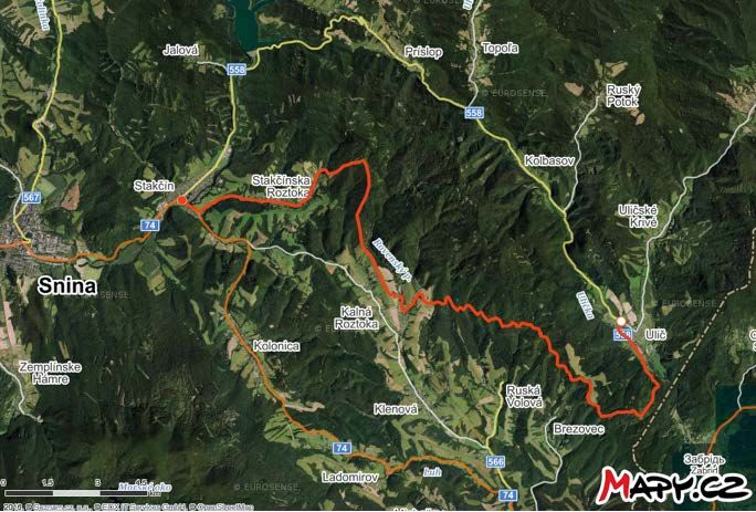
FIGURE 20 Start of Porta Rusica leading up to Ruské Sedlo, the border between
Poland and the Slovak Republic                                                        31
FIGURE 21 Map of Runina — Ruský Potok — Uličské Krivé hiking circuit                  33
FIGURE 22 Map of hike from Nová Sedlica North West                                    33
FIGURE 23 Current hiking trail network within the park (red, blue, and yellow
marked trails).                                                                       34
FIGURE 24 Route from Ulič to Príslop                                                  34
FIGURE 25 Route from Stakčín to Príslop                                               34
FIGURE 26 Stakčín to Jalová to Veľka Poľana off the paved road.                       34
FIGURE 27 Map of equestrian route 1 — begins in Snina and finishes atop the Ruské
sedlo, via Porta Rusica                                                               35
FIGURE 28 Beautiful tree seen during equestrian trail inspection northeast of Snina   35
FIGURE 29 Map of route from Parihuzovce                                               36
FIGURE 30 Map of route from Pčoliné                                                   36
FIGURE 31 Map of route from Diakov (Osadné) to Veľka Poľana                           36
FIGURE 32 Map of route from Snina to Smolnik via Osadné                               36
FIGURE 33 Circuit route 1 from Veľká Poľana via Hodošik                               37
FIGURE 34 Circuit route 2 from Veľká Poľana via Hodošik and Ruské ski hill            37
FIGURE 35 Peter Sagan at the Tour de Suisse, June 20, 2019                            39
FIGURE 36 Park protection levels map                                                  44
FIGURE 37 Map of landownership in Poloniny                                            45
FIGURE 38 U.S. Forest Service trail management tools webpage                          50
FIGURE 39 Official trail markings                                                     51
FIGURE 40 A hiker in the Jarabá Skala nature reserve                                  52
FIGURE 41 U.S. Forest Service Design Parametersfor Hiking Trails                      52
FIGURE 42 U.S. Forest Service Design Parameters for Bicycle Trails                    55
FIGURE 43 Gaining experience in the field with an expert rider near Osadné            57
FIGURE 44 Design Parameters for Equestrian Trails                                     59
FIGURE 45 Parcel ownership along the route from Veľka Poľana to Hodošik.              73
FIGURE 46 Map showing trail access between Poloniny and Ukraine                       80
FIGURE 47 Map showing ‘bikes to tajchs’ routes                                        83
FIGURE 48 Map showing hiking and cycling trails in NP Muránska Planina                85

TABLES

TABLE 1 Number of infrastructure improvements needed                                  26
TABLE 2 Accommodation in and outside Poloniny Park                                    62
TABLE 3 Rest Areas and Water Access                                                   63
TABLE 4 Driving distances and durations between Snina and other destinations          67
TABLE 5 Train travel times between Stakčín and other destinations                     67
ACKNOWLEDGEMENTS

To develop this report, a World Bank Group team conducted multiple missions, field visits, and
workshops in the Slovak Republic, during which it collaborated with Slovak experts. Guidance
in the process was effectively provided by Paul Kriss (World Bank Lead Urban Specialist).

The team is indebted to the executive and administrative staff of the Prešov Self- Governing
Region that generously offered its premises, support staff and endless hours of dynamic and ded-
icated discussions in meetings. In this context, the World Bank Group team is particularly thank-
ful to Dr. Rudolf Bauer and Ms. Maria Biľová.

Furthermore, the team is thankful for the support provided by the Deputy Prime Minister’s Office
for Investments and Informatization of the Slovak Republic, Mayors and Council Members of Local
Governments in the Snina District, Poloniny National Park Administration, Forestry Property
Enterprise Ulič, and all other stakeholders consulted during the process, whose contributions
have been essential.

Last, but not least, special thanks go to all the Slovak and international experts who have directly
contributed their expertise in shaping the following report and analytical findings. The report
col-lates contributions from Dr. Guido Licciardi (World Bank Senior Urban Development Specialist),
Scott Wayne (World Bank consultant), Dr. Jordanka Tomková (World Bank consult¬ant), and field
experts working directly within the region comprising of Peter Bujňák, Viera Štupáková, Vladislav
Juško and Mário Perinaj.

The findings, interpretations, and conclusions expressed herein are those of the authors and
do not necessarily reflect the view of the World Bank Group, its Board of Directors, or the gov-
ernments they represent.

                                                                                                       7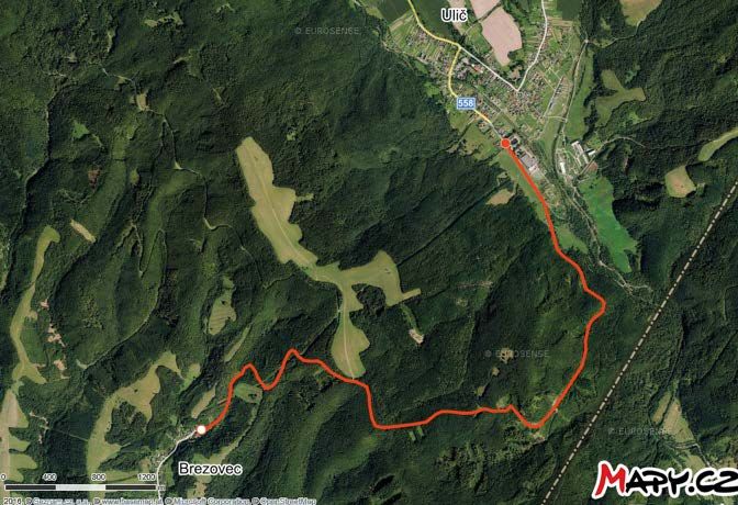
ACRONYMS
AND ABBREVIATIONS
ATV All-terrain vehicle
CuRI Catching-Up Regions Initiative
DMO Destination Management Organization
DMS Destination Management System
EC European Commission
EFA Ecological Functional Area
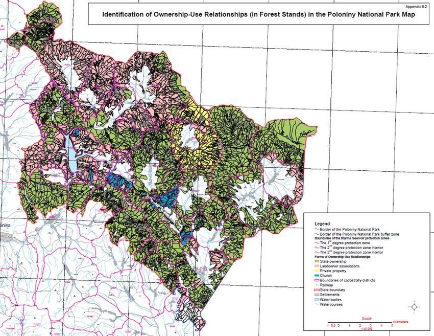
GDP Gross Domestic Product
ICT Information Communication Technologies
KOCR Krajská Organizácie Cestovného Ruchu (Regional Destination
Management Organisation)
KST Klub slovenských turistov (Club of Slovak tourists)
MTB Mountain Biking Trails
NP National Park
NR Nature Reserve
NRR National Nature Reserve
OOCR Oblastná Organizácia Cestovného Ruchu (Sub-Regional Destination
Management Organisation)
OECD Organization for Economic Cooperation and Development
PPT Poloniny Park Trail
PSK Prešovský Samosprávny Kraj, Prešov Self-Governing Region
R-DMO Regional Destination Management Organization(s)
SME Small and Medium Enterprise(s)
TDMIS Tourism Destination Management Information Systems
TZT Turistické značkované trasy (standardized methodology for trail marking
in SR and CZ)
TIC Tourism Information Center
UNESCO United Nations Educational, Scientific and Cultural Organization
UNWTO UN World Tourism Organization
WB World Bank
WBG World Bank Group
WTTC World Travel & Tourism Council
8 Due Diligence Report on the Establishment of a Poloniny National Park Trail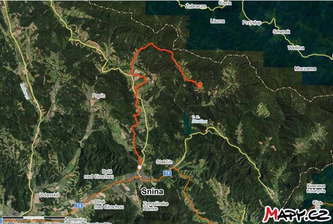
SYNOPSIS

The following report focuses on what is needed to establish the Poloniny Park Trail—one of the
main recommendations of the Output 2 Report. The Trail is intended to connect communities in the
park towards increased community engagement
and economic empowerment by forming a single FIGURE 1 The main map of Poloniny Trail
brandable, more marketable and cohesive tour-
ism product. A team of trail experts conducted
extensive field research, document reviews, and
stakeholder meetings on, and related to, the
trail. One of the main results is this initial full
Poloniny Park Trail map (Figure 1).

Additional maps have been developed for specific
Poloniny Park Trail (PPT) sections and each of the
key activity areas — hiking, cycling, and horse-
back riding. These maps are provided through-
out this report to present the individual sec-
tions, as well as off-shoot routes that connect
to interesting natural or cultural landmarks.
All route variations and individual sections are
in relation to the above overall Poloniny Trail          Distance: 120.7 km     Altitude profile:   2,736 m   2,753 m

map. To the extent possible, infrastructure
                                                     239 m.a.s.l.
needs, such as water access and rest area facili-
ties (toilets, tables, and so on), have been high-
lighted and mapped (see below Existing Trail
                                                                              30 km                           60 km
section and Annex 5).

KEY FACTS ABOUT THE TRAIL
The Poloniny Park Trail can comprise over 110-kilometer-long circuit with another over 100 kilo-
meters with possibilities to connect to an existing network of trails, attractions, and communities:

   1.   125 kilometers of marked hiking routes within and around the national park
   2.   308 kilometers of cycling trails
   3.   10 communities along the trails
   4.   95+ national and local cultural monuments, shrines, and sites
   5.   80+ notable natural attractions and viewpoints along or near the trails
   6.   100 kilometers of planned equestrian trails

                                                                                                                        9
INTRODUCTION
This Preliminary Due Diligence Report for the NP Poloniny builds on a key recommendation
in the recent Output 2 report of the European Commission’s Catching-up Initiative (CuRI) for
the Presov Self-governing Region (PSK). In that report, which focused on tourism, a World Bank
team of experts, in coordination with PSK experts and local stakeholders, recommended that the
NP Poloniny becomes a more developed adventure travel destination. To achieve this, the team
recommended focusing on the development of a core NP Poloniny Trail with subsidiary trails
suitable for activities such as hiking, cycling, and horseback riding. Best practice examples, such
as the Lebanon Mountain Trail, provide some useful elements for replication and adaptation in the
NP Poloniny. This report provides an overview of key elements related to NP Poloniny, existing doc-
umentation, and a preliminary mapping of trails that could be packaged, branded, and presented
as ‘NP Poloniny Trails,’ as well as the initial trail condition reports. Achieving this overcomes the
lack of cohesion in Poloniny as a destination.
The NP Poloniny is one of three parks comprising the East Carpathian UNESCO Biosphere Reserves;
the other two are adjacent to Poland and Ukraine. NP Poloniny is in the north eastern region of the
Slovak Republic, one of the most remote areas in the country. It covers an area of 29,805 hectares,
and has officially been declared a national park since 1997. The park is a home to 10 villages with
a total population of around 2,600 people. The villages are Jalová, Príslop, Kolbasov, Ulič, Uličské
Krivé, Ruský Potok, Zboj, Nová Sedlica, Topoľa, and Runina.
The Park is characterized with dense primeval forests, unique flora and wildlife, such as, the
European bison. It unites seven national natural reserves and 12 natural reserves, which cover
an area of 10,973 hectares of strictly protected reserves. The park is also home to bison, wolves,
over 200 species of birds, 24 species of fish, and 63 mammal species.
The park also hosts numerous cultural landmarks, such as the wooden churches in the villages
of Jalová, Topola, Ruský Potok, Uličské Krivé, and other neighboring villages just outside the park
boundaries. Most of these churches, as well as the natural reservations, are also designated cul-
tural and natural UNESCO sites. The region is also home to the traditionally Christian Orthodox
Rusyn (Ruthenian) ethnic group, who have lived there for a thousand years. Both world wars also
left their mark on this region, which has left behind unique relics and monuments of remem-
brance for the lives lost during the battles throughout the region.
Combination of natural splendor and cultural heritage in the region holds for the NP Poloniny
a great opportunity to become a competitive adventure travel destination (see definition below).
An adventure destination requires a central point of orientation merging its unique natural and
cultural attractions with active recreation such as hiking, cycling, horseback riding, and/or other
activities, thus creating an array of experiences appealing to adventure travelers. Hence, the idea
of a Poloniny Trail is greatly positioned for such vision.
In designing the Poloniny Trail, the team and stakeholders endeavored to meet the requirements
of adventure travel families, as another dimension of tourism development within the region.
Hence, family travel was kept in mind while analyzing alternate cycling routes, based on ease
of terrain, available parking, recreational vehicle amenities, public amenities, and isolation from
10 Due Diligence Report on the Establishment of a Poloniny National Park Trailroad traffic. However, the park’s topography and FIGURE 2 Typical Poloniny fields atop the numerous hills
terrain do limit potential cycling routes for the and peaks
recreational cyclist and/or a family of cyclists.
Hiking trail outlets on, or along the Poloniny
Trail, are aimed at reducing some of the vast
distances, by creating a network enabling the
visitor to combine routes and create a circuit
of desired length. This and other considerations
are part of this report.
The purpose of the PT project is to be part of the
precedent for the future socio-economic devel-
opment of the region, and to commence multi-
dimensional cooperation among different lev-
els of government and local enterprise:
1. Increase cooperation of stakeholders
in the Poloniny region during trail plan-
ning and design
Source: Peter Bujňák
2. Develop a new entity, or improve existing
organizations, to implement quality tour-
ist infrastructure pertaining to the Polon-
BOX 1 Adventure Travel Defined
iny Trail and park as a travel destination
Adventure travel is a form of travel that combines physical activity
3. Develop a travel destination product for with cultural experience. According to the Adventure Travel Trade
the Poloniny region via the initiation and Association (ATTA), adventure travel requires three components
to be present – physical activity, cultural immersion, and natural
involvement of local and regional service
environment. This type of travel is meant to connect the traveler to
providers and stakeholders an area by experiencing nature and culture with physical activity.
Activities such as hiking, cycling, horseback riding, rafting, climbing,
4. Work with the Krajská Organizácia Ces- skiing, and others, are actively pursued while immersed in a new
tovného Ruchu (KOCR/R-DMO) and sub-re- culture and landscape.
gional DMOs—Oblastné Organizácie Ces- According to research from the ATTA, the adventure and na-
tovného Ruchu (OOCR/S-DMO) to develop ture-based travel industry is now worth more than US$ 683 billion,
sustainable promotion and management and since 2012 has been growing at approximately a 21% compound
annual growth rate (CAGR). Furthermore, in the 2017 ATTA Adven-
strategies that help define the Poloniny
ture Pulse, a survey of leading adventure tour operators, the most
Trail and park, as well as the entire region, demanded outdoor activities were hiking and biking, a finding that
as a unique and distinct travel destination bodes well for the Snina District and Poloniny Park.
In addition, while the research found that experiential travel (both
The Poloniny Park Trail (PPT) is intended to be- nature and culture-based) has a broad appeal, the highest level of
come the main multiuse trail connecting exist- interest is especially among young people – Millennials or Generation
ing cycling, hiking, and potentially equestrian Y (born between 1981 and 2000), and Generation Z (born between
2001 and 2019). If experiences are developed to appeal to these age
trails (depending on the section of trail), with-
groups, there might also be increased interest to pursue entrepre-
in and around the park. The PPT passes through, neurial experience-based businesses and opportunities in the Snina
or connects to, the most significant natural and District and Poloniny Park, thus reversing the depopulation trend.
cultural landmarks within and near the park.
The PPT could use existing forestry road infra-
structure and minimize the construction of new roads. While not technically challenging, the
terrain in the NP Poloniny is relatively steep, which must be considered when designing and map-
ping the trail, especially for cyclists and horseback riders.
Introduction 11HISTORICAL AND CULTURAL CONTEXT
OF THE NATIONAL PARK
The natural environment in Poloniny is spectacular and central to the Park’s offers, but the cul-
tural and historical context are also important to developing positive and authentic experiences
in the Poloniny Park Trail. For example, simply seeing the Starina water reservoir, without under-
standing the political and social unrest that accompanied its construction, is an incomplete picture.
The reservoir development, beginning in 1983, caused the destruction of seven Rusyn villages,
and the displacement of 3,463 people from 769 homes. The villages of Dara, Ostrožnica, Ruské,
Smolník, Starina, Veľká Poľana, and Zvala were depopulated and subsequently destroyed dur-
ing the 1970’s to early 1980’s, with only a few remnants remaining today. The reservoir takes its
name from Starina village, which was flooded by the reservoir. Remnants include mainly ceme-
teries and religious monuments from the former villages, but all major objects, such as churches,
were destroyed or removed. Today, areas such as Ruské are lined with recreational cottages, with
Poloniny offering a picturesque backdrop.
When first entering the park, a visitor is awe struck by the sheer expanse of the park’s forest can-
opy. While much of the park is a relatively untouched natural environment with minimal human
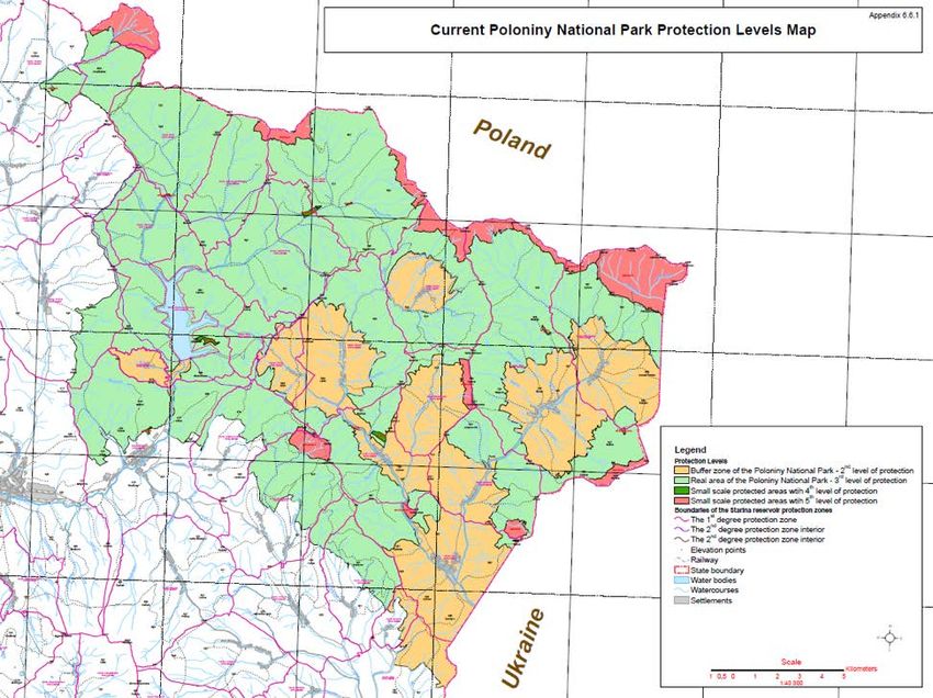
interference, the park is also home to communities and commercial forestry operations. The lat-
ter comprises 65% of the total park land, with 27% under private ownership and eight percent des-
ignated as protected reserves.
The logging industry is an important economic activity of the park that dates back centuries and
now supports over 200 families in the Snina District, thus making it the largest local employer,
and an important dimension of local heritage. For tourism to be developed in the park, it must be,
and from the team’s perspective can be, complementary with logging.
Foresters play a key role in the health of the forests in the region. Historically, prior to the region
being designated a national park, foresters were responsible for afforestation, expanding the for-
est from 1947 onwards, when the first state forestry administration was established in Stakčin
and Ulič. Given the history of the region, these two sectors cannot be treated as exclusive enti-
ties, but should be combined effectively. For example, sustainable forestry management is essen-
tial for the strengthening of adventure travel and ecotourism in the region. The forestry organi-
zation can help ensure trail access throughout the park (see further details in Risks, Challenges,
Obstacles and Opportunities).
According to Peter Šiška, Director of the Forestry Organization, the organization can help ensure
trail access throughout the park. He has commented that the forestry industry in the Slovak
Republic is in transition. While logging and forestry have historically been critical to local liveli-
hoods, society, and the economy, as panelists at the June 2019 Catching-up Regions Initiative con-
ference in Prešov emphasized, the local population is aging, and young people are not choosing
logging as a profession. To sustain and further develop the local economy, panelists agreed that
other options were needed, such as sustainable tourism. The logging industry has also been ham-
pered by aging technology that has constrained the competitiveness and efficiency of forestry man-
agement. As Mr. Šiška emphasized, it is in the interest of the Forestry Organization to increase
their management capacity and upgrade their technology, while simultaneously diversifying into
other forestry-related areas, such as recreation, adventure travel, and ecotourism. The US Forest
Service is a prime example where both tourism and commercial forestry can be compatible, and
operate in mutually beneficial and sustainable ways. The trail is intended to be the ideal common
ground for all stakeholders.
12 Due Diligence Report on the Establishment of a Poloniny National Park TrailMETHODOLOGY
The main purpose of this report was to develop the initial Poloniny Park Trail map with GPS coor-
dinates marking areas of needs, and points of interest for potential trail cyclists, hikers, and rid-
ers. To determine this map, background research and extensive field work were conducted. For the
latter, a field team led by adventure expert Peter Bujňák, and including Viera Štupáková (cycling
expert), Vladislav Juško (equestrian expert), and Mario Perinaj (Director of Poloniny Park) pro-
vided details as to possible trail routing, infrastructure, and service needs, as well as points of his-
torical, cultural, and natural interest. Peter pursued the following intense itinerary:
1. June 6, 2019—General inspection by car of accessible routes throughout the park, from
Stakčín to Nová Sedlica, and from Stakčín to Ruská Volová via Kalná Roztoka
2. June 7—Snina- Stakčín section inspected by bike
3. June 8–9—Trail excursions began and included the marking of points of interest, poten-
tial rest areas, sign improvement needs, as well as discussions with residents; 75 kilome-
ters covered by bike
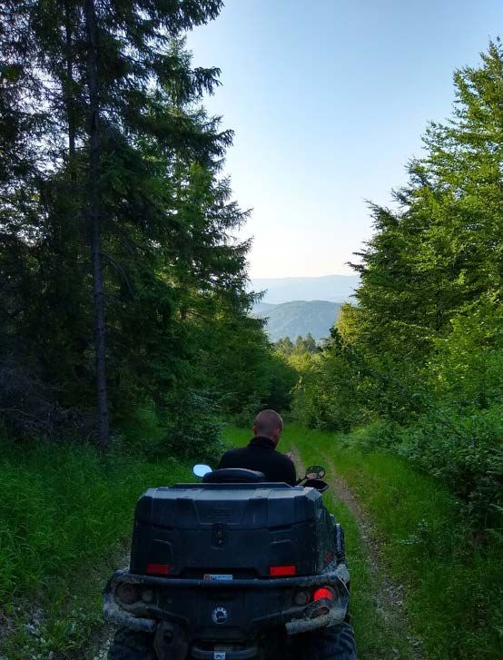
4. June 10—Trail inspections by all-terrain vehicle (ATV), covering the southern part of the park,
including the corridor between Nová Sedlica and Ulič
5. June 11—Entire northwestern area of the park inspected by SUV, including from Pčoliné
to Osadné area, including Udava. Emphasis on equestrian potential and bison viewing, with
consideration of opportunities also for cyclists and hikers. This is an important stretch for
possible connectivity to trails and villages in and around Starina
6. June 13—Trail inspections by ATV, covering 120 kilometers along the southern slopes above
Príslop to Kolbasov, and then from Ruský Potok to Zboj, and the forest road from Nová
Sedlica to the intersection of the yellow route to Jarabá skala and the forest road, which
paralleled the ridge line from Ďurkovec to just before Vel’ky Bukovec. The team explored
part of this ridge by foot and inspected an old fire road along this ridge, and then returned
to Nová Sedlica
7. June 22—Trail inspections by ATV covering the northwestern boundary of Poloniny Park along
the Snina to Osadné corridor (conducted by Vladislav Juško). Equestrian requirements were
considered, although the multipurpose use of the route was also considered. This route be-
gins at the mini zoo compound in Snina, and follows forest road networks and paths along
the northern corridor. Main factors considered were elevation and minimal contact with
motorized roads and traffic (only required for crossing from west to east of the main corri-
dor). The route inspection passed through Pčoliné, Parihuzovce, and continued to the for-
mer villages of Zvala and Smolník
To conduct these inspections, factors such as slope incline, property boundaries, and zoning for
environmentally sensitive areas were considered and reflected in the GPX files. Initial trail map-
ping was conducted, using the online mapping application www.mapy.cz, which uses ‘open street
13FIGURE 3 Trail inspection from Prislop to Stakčínska Roztoka maps’ (open source data) as their source, and
indicates levels of slope inclination. The route
followed was based on existing marked trails,
as well as logging roads. However, sections were
discovered that historically had a path running
through it, yet were absent in all online mapping
applications, including Google Earth. The ini-
tial route was reviewed with the team and then
mapped using online mapping applications and
GARMIN’s Base Camp program.
At the time of writing, the team was waiting
on additional feedback from the locals and from
the University of Prešov ArcGIS experts on road
quality, slope, and terrain for more precise route
inspections. Trail inspections resulted in the
separation of cycling and equestrian paths from
hiking paths, as hikers have different demands
for trails compared with other users (see hik-
ing section for details). Unsatisfactory sections
of the route and possible route variations were
determined. Multiple route options were con-
sidered with special attention to trail or road
incline and slope, and road condition quality.
The resulting Poloniny Trail recommendations
are based on what optimal slope and road condi-
tions are for cyclists, hikers, and horseback riders.
The field team was supported with reporting and
research by World Bank official Guido Licciardi,
and World Bank consultants Scott Wayne and
Source: Peter Bujňák Jordanka Tomkova.
14 Due Diligence Report on the Establishment of a Poloniny National Park TrailSITUATION ANALYSIS
OVERALL
     The Snina District and Poloniny Park offer nature-based and cultural experiences and attrac-
     tions that, given international demand trends, could become genuinely competitive, if they are
     further developed. Both sets of activities are increasingly considered experiential travel—travel
     that is immersive, local, authentic, active and/or adventurous—that is, traveling to experience
     nature-based and cultural adventure. In fact, a 2018 study from the Adventure Travel Trade
     Association (ATTA) referenced above found that “experiencing a new culture” is now often included
     in the definition of adventure travel. So, when considering adventure travel demand, it is often
     combined with cultural tourism as experiential travel, of which Poloniny Park offers great desti-
     nation potential. To develop these opportunities will require increased local coordination, infra-
     structure, and product improvements, as well as increased tourism and hospitality skills.

     KEY ACTIVITIES AND POINTS OF INTEREST
     IN NP POLONINY: SIGNIFICANT CULTURAL
     AND NATURAL LANDMARKS

     Despite having over 27,000 hectares of forests (in Poloniny Park), presently, there is only a lim-
     ited network of hiking, horseback riding, and cycling trails available. Improvements are needed
     to facilitate better access for more visitors and provide more variety of excursions. The area also
     hosts an internationally known ‘dark-sky park’ (at the edge of Poloniny), and multiple cultural
     monuments, sites, and institutions in local communities.

     Hiking tops the list of preferred activities in the Snina District. According to the Snina Action
     Plan, the most frequent reason for visiting the district is hiking in the National Park Poloniny and
     Vihorlat Protected Landscape Area (CHKO), which is especially popular among the most numerous
     visitors—Slovaks, Czechs, and Polish tourists—who comprise 90% of all visitors.

     Existing Trail Network

     The Poloniny Park hiking and cycling trail infrastructure is in its infancy compared with other
     national parks and protected areas in the Slovak Republic (see Annexes). When considering the
     natural splendor offered by Poloniny, the current trail network is quite limited and does not accu-
     rately reveal the full natural value and potential of the region for the visitor. The park is still rel-
     atively undiscovered by tourists, in part due to the limited hiking, cycling, and horseback riding
     trails that are marked in the park. The horseback riding potential is particularly untapped, since
     there is no mention of this activity on any of the park information boards or pamphlets.

     Communities

     As the map (Figure 4) shows, the NP Poloniny and areas adjacent to the Park include the follow-
     ing communities: Jalová, Príslop, Kolbasov, Ulič, Uličské Krivé, Ruský Potok, Zboj, Nová Sedlica,
     Topoľa, and Runina.

18   Due Diligence Report on the Establishment of a Poloniny National Park Trail
Cultural Sights FIGURE 4 The Map of the communities
and Natural Attractions in the NP Poloniny area
The Snina District and Poloniny Park offer more
than 140 sites and attractions, many of which
could be of interest for visitors to the Poloniny
Park Trail. Several of these sites, such as the
wooden churches, military cemeteries, the min-
iature wooden church park, and Three Springs
pilgrimage site, have been restored and are being
well maintained. Many other sights, however,
require improvements. Here is a summary of
some of the key needs:
1. Approximately 39 of 140 sights are cur-
rently inaccessible and require signage im-
provements, better mapping, and/or phys-
ical access.
2. Numerous lookout points throughout the
park, including the Príslop radio tower,
offer spectacular views, but lack required
infrastructure and/or signage, and are sometimes not even indicated on maps, nor on near-
by hiking trails.
3. The Slovak Republic’s highest elevation military cemetery at Hodošík, is accessible by road,
but there is no marked path for visitors.
4. The wooden churches can all be visited and seen from outside. However, entering them re-
quires assistance, and thus signage or other information indicating who to call for access.
5. Attractions, such as the outdoor chapel in Veľka Poľana and the NR Pod Ruským, are easy
to miss, due to a lack of signage.
Similar experiences were found during the trail inspections throughout the park that could be eas-
ily improved, and thus packaged as Poloniny Park Trail experiences. These experiences could,
in turn, enable Poloniny to compete with sim-
ilar destinations in the region. FIGURE 5 Wooden church of St. Michael, the Archangel,
from the mid-18th century, Topoľa
The full list of cultural monuments and natural
attractions in the Snina District can be found
in Annex 2. Some of the most distinctive and
historic attractions include:
A. Distinctive 18th Century Wooden
Churches
The wooden churches of the region offer win-
dows into 18th century, and with information
and guides, offer incredible stories on history
and culture.
1. Wooden church of St. Michael,
the Archangel, from the early 1700’s,
Ruský Potok Source: Peter Bujňák
Situation Analysis 192. Wooden church of St. Michael, the Archangel, from the mid-18th century, Topoľa
3. Outdoor miniature wooden church park, Ulič
4. Greek Catholic wooden church from 1718, Uličské Krivé
5. Greek Catholic wooden church of St. John the Baptist, Kalná Roztoka
6. Wooden church exposition, Topoľa
7. Greek Catholic wooden church of Saint Juraj (George) from 1772, Jalová
B. WWI and WWII Cemeteries
The many military cemeteries attached to nearly every community in and around Poloniny Park
are important and somber reminders of the human toll paid by the Slovaks in the world wars of the
20th century. These cemeteries include:
1. Military cemeteries can be found in the following park communities: Kolbasov,
Čišovatyj Runina, Topoľa, Ulič, Zboj, Dara*, Ostrožnica, Ruské, Starina, Smolník,
Veľka Poľana, Predný Hodošík, and Zvala.
2. Military cemeteries can also be found in the following communities outside the park:
Hostovice, Osadné, Snina, Giglovo, and Ubľa.
C. Jewish Cemeteries and Memorials
The Jewish population in the eastern Slovak Republic suffered, as well, in World War II. Several
memorials and cemeteries can be found in Kolbasov, Runina, Topoľa, Snina, and Ubľa.
D. Other Interesting Attractions and Sights
Inside the park:
1. Nová Sedlica and vicinity—Honey Woman’s wooden sculpture, and a nearby waterfall
2. Kremenec—(highest peak and tri-border), and the outdoor Slovak–Rusyn dictionary
3. Runina—An astronomical observation point
4. Topoľa—Paragliding take-off site on Bukovec peak
5. Ulič—Poloniny gallery of wooden statues
FIGURE 6 Historic park part of late Baroque manor Outside the park:
grounds in Snina 1. Snina—A late Baroque manor from the
18th century and historic park
2. Kolonica—Astronomical observatory
3. Osadné—Marked hiking trail railway
station, Balnica (small gauge railway
line), and mineral spring Udavy
4. Stakčín—Pathway
of the small gauge forestry railway
from Stakčín–Strihovec, and the town
cultural heritage museum
5. Zemplínské Hamre—Outdoor mining
exhibition
The following map (Figure 7) indicates attrac-
tions in and around each community in Polon-
Source: Peter Bujňák iny. Annex 2 presents the list of these attractions.
20 Due Diligence Report on the Establishment of a Poloniny National Park TrailFIGURE 7 Map of the key attractions in and around the park
Natural Attractions
Prešov Region is well endowed with multiple nature-based attractions and sites that draw both
domestic and foreign visitors. These sites include five national parks1, 180 protected areas, nature
reserves, UNESCO protected beech forests, geothermal springs, the astronomical observatory
near Kolonica, and beekeeping operations. The NP Poloniny, along with the neighboring parks
of, Bieszczadzki National Park in Poland and Uzhanian National Nature Park in Ukraine, offer
opportunities for transnational park and tourism cooperation, particularly for extended hiking
and biking trails, which can be a good selling point.
The Snina District and the National Park Poloniny currently generate limited demand for adven-
ture and nature-based travel. Some of the nature-based attractions include astronomical tourism,
birdwatching, especially the twitching Ural owl, woodpecker and hazel grouse; wildlife viewing
of bison; and occasionally—with luck and/or professional tracking—wolves and bears.
Birdwatching offers opportunities for further development in the Snina District. With over 15,000
hectares of protected bird areas and 211 bird species2, the district could become an optimal area
for birdwatching. According to the Poloniny National Park Management Plan, the park includes
Situation Analysis 2162% of the bird species in the Slovak Republic. The Starina reservoir construction helped create
good conditions for the breeding of several rare bird species and aquatic birds; it also is located
on a significant migratory route to the south and back, across the Eastern Carpathians between
Poland and the Ukraine.3
The Poloniny National Park needs improved and new lookout points to enable visitors to fully
appreciate the beautiful landscape, and to foster activities such as birdwatching and bison watching.
Residents recommended installing a wooden bison statue at points where bison watching is the best.
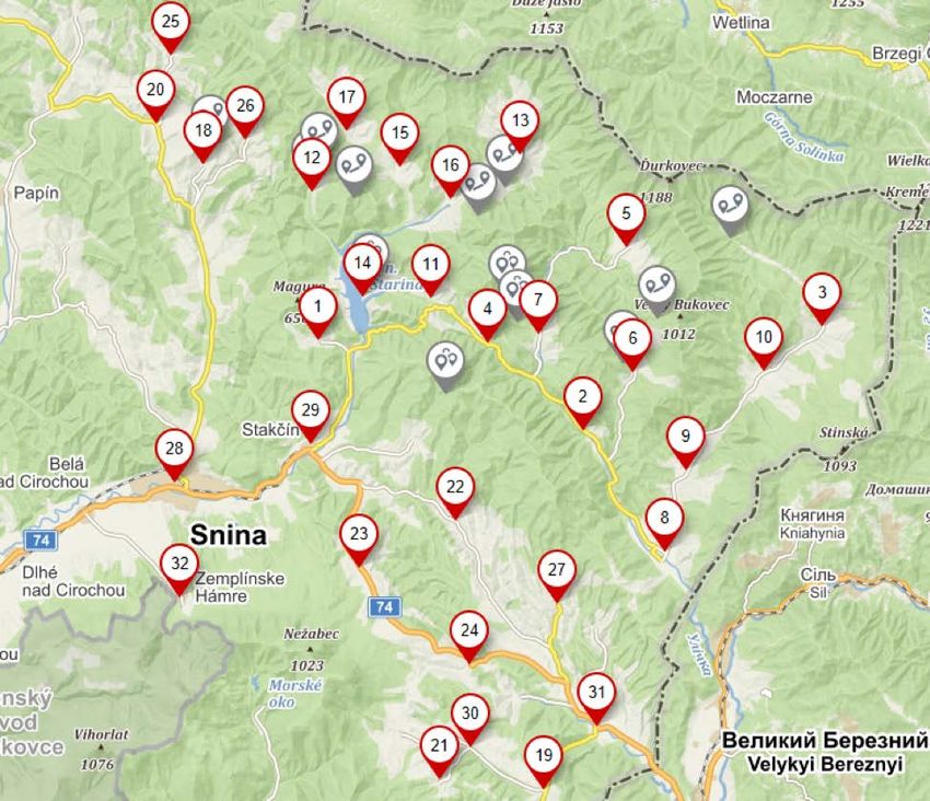
22 Due Diligence Report on the Establishment of a Poloniny National Park TrailEXISTING AND PROPOSED TRAIL NETWORK BY ACTIVITY
In conducting the inspections for each trail section, and meeting with the stakeholders, the team
                      identified at least 114 infrastructure improvements. The list of improvements is not exhaus-
                                                                         tive and may change as the route development
TABLE 1 Number of infrastructure improvements needed                     progresses. Some improvements, such as vis-
                                                                         itor parking, public restrooms, and recrea-
 Infrastructure type:                           Number needed
                                                                         tional vehicle campsites, are recommended for
 Bridges                                        4
                                                                         every village in the park. These infrastructure
 New Rest Areas                                 14                       requirements should be understood as being
 Improved Rest Areas                            3                        phased in, starting with priority areas, as visi-
 Shelters                                       5                        tor numbers increase. Infrastructure require-
 Lookout Towers                                 10
                                                                         ments,  such as bridges and rest areas, might
                                                                         also increase or decrease, depending on the
 Improved Signage                               30
                                                                         route and other factors, such as permits to build
 Improved Water Sources                         3
                                                                         in specific areas.
 New Equestrian Campsites                          3
 Self-serve Bike Service Stations                  4                           The following map (Figure 8) is a partial rep-
 New Recreational Areas                            2                           resentation of an interactive online map that
 RV Campsites                                      10                          shows GPS coordinates and specific needs for
                                                                               each point. The improvements and their location
 Visitor Parking Areas                             10
                                                                               can be viewed in detail via the following link:
 Public Restrooms                                  11
                                                                               https://en.mapy.cz/s/3uuzw.

FIGURE 8 Map indicating locations of the required infrastructure

26                       Due Diligence Report on the Establishment of a Poloniny National Park Trail
CYCLING
The district hosts eight main cycling trails totaling about 309 kilometers, two of which connect
the Slovak Republic with Poland and the Ukraine, and one that connects the Slovak Republic with
the Ukraine. These include: the five-country Carpathian Cycling Route project, with 65 kilome-
ters in the Snina District and along the edge of the park; and the Green Route, with 52 kilometers
also in the district and park. In fact, as the team’s local cycling expert, Viera Štupáková, explained,
the Green Route overlaps and connects with the Porta Rusica Trail, which has been approved for
€ 2.2 million in funding for trail improvements. Notably, the Slovak Republic’s most well-known
hiking and outdoor web portal—hiking.sk—with their online mapping application—turistick-
amapa.sk—lacked all cycling routes, except for
route 016 around Starina water reservoir and FIGURE 9 Map of cycling circuit 1 from Stakčín
up to Ruské Sedlo. With trail improvements
in Poloniny, the team recommends that these
routes be added.
A major attraction point for cyclists is the Porta
Rusica at the northern edge of the park, an an-
cient trade route built between 1861–1865 made
of stone, that is due for restoration. The Por-
ta Rusica, however, is an end point for visitors,
meaning that if a cyclist were to continue, he or
she would continue into Poland and leave the
Poloniny Park. On the other hand, the planned
restoration of Porta Rusica could see a rise in cy-
clist visitors from the Polish side, who are inter-
ested in seeing the restored historic trade route.
Given the lack of monitoring of trail visitors, es-
timates as to the total numbers of cyclists from
Poland are uncertain.
While the Park lacks circuits for cyclists, there
are two existing possibilities to create circuits
from the different marked trails:
1. Starting in Stakčín, south west of Starina,
the route continues along Ruské to Topola, FIGURE 10 Map of cycling circuit 2 from Stakčín
and returns to Stakčín, totaling just un-
der 50 kilometers—a reasonable one- to
two-day circuit. Roughly half the route
shares the road with car traffic.
2. The route starts and ends in Stakčín, along
the southern side of the park for just over
53 kilometers, passing through Príslop
and Kolbasov, and then continues on to
Ulič along a semi-paved forest road, con-
necting to Ruská Volová, where it contin-
ues alongside the road to Stakčín, pass-
ing through Klenová and Kalná Roztoka.
While the route provides decent scenery
and connects multiple communities, it
does not show the vast natural attractions
of the park. The cyclist may be left wonder-
ing what lies beyond the road within the
UNESCO designated primeval forests. Over
80% of this route is shared with car traffic.
Existing and Proposed Trail Network by Activity 27In their present state, neither circuit is appropriate for family cyclists, nor for road cycling, due
to the road traffic and the surface quality in certain areas. Overall, they are best for the recrea-
tional sport cyclist who uses trekking bikes. Road cyclists would have to backtrack, and families
with children would most likely want to avoid roads with car traffic. The construction of new trails
along flatter sections of terrain could address the lack of family-oriented cycling routes, whereas
the improvement to certain sections of marked routes, could significantly improve the appeal
of the region for the road cyclist (see below for further details).
Another notable cycling trail in the region is the IKON Cycling Path, a premier trail that starts
in Nová Sedlica, continues along the main road to Stakčín and beyond the park boundaries via
Kalná Roztoka, Ubľa, and ending in Inovce, for a total of 109kilometers. This trail passes by several
impressive UNESCO heritage wooden churches. As with the other trails, it shares the road with car
traffic, but can be considered one of the most effective means of covering many kilometers along
relatively simple terrain. However, a cyclist must first travel to Nová Sedlica to reach this route.
Currently, there are no buses equipped with bike racks, while driving to the village means that the
cyclist must return to retrieve his or her car, unless they have organized transport.
The marking and signposting of most cycling trails is provided by the nongovernmental organization
(NGO) DO Fenix Snina; the Carpathian cycling trail was marked by the Prešov Bicycle Group Kostitras.
Since most of these and other cycling trails in the park share paved roads with motor vehicles for
most of their lengths, these are appropriate mainly for the sport cyclist or cycling tourers, rather
than families. These trails, however, only skirt the edge of the park, and do not really offer the
visitor the opportunity for the full appreciation of its natural beauties and breathtaking vastness.
Furthermore, pertaining to cycling (as well as horseback riding), the natural topography of the
park is a major determining factor, placing limits on the development of diverse cycling routes for
all fitness levels within the national park.
The cycling trail from Starina north to Porta Rusica, via the former village of Ruské, is an excep-
tion that deviates from a paved road and then finishes on the main road between Topoľa and
Runina, thus offering relatively easy access. While it does not pass through any areas with wooden
churches, the route passes by, or provides access to, significant WW I military cemeteries, includ-
ing Hodošik (the Slovak Republic’s highest elevated military cemetery), the remnants of the former
villages Veľka Poľana and Ruské, and a ride up the Porta Rusica. Out of the current offer of marked
cycling routes, the Porta Rusica offers by far the most in terms of immersion in nature, providing
great views, and a sense of history, as the visitor cycles along the cobbled stone road (with scope
for restoration). Car traffic along the Starina route to Ruské and beyond to the north of Topola
is minimal (only by permit and limited to 60 personal cars per day). Therefore, the level of motor-
ized traffic does not seem to be an issue along this portion of trail. During the trail inspections
between June 7–9, 2019, directional signs were found to be missing at numerous intersections
along the route or were of poor quality and required repainting. Rest areas and shelters were also
lacking along this route.
The team found route possibilities away from road traffic throughout the park that utilized exist-
ing forestry roads. Some of these routes also connect villages in the park area with potential new
routes that follow more challenging terrain than the paved road trails, and are thus, more appro-
priate for an active or sport cyclist. The section below describes trail requirements for cyclists.
28 Due Diligence Report on the Establishment of a Poloniny National Park TrailForestry Road Cycling Trail Profile: Runina — Ruský Potok — Uličské Krivé
This trail (inspected on June 9 and 10) uses ex- FIGURE 11 Forestry road cycling trail:
isting forestry road infrastructure consisting of Runina — Ruský Potok — Uličské Krivé
numerous ascents and descents, making it phys-
ically challenging. Numerous parts of the route
require intensive trail improvements, but pro-
vide some spectacular scenery, including rides
through typical Poloniny fields. Some sections
(just before entering Ruský Potok) were missing
entire road sections. The section from Ruský Po-
tok to Uličské Krivé offered nice scenery and an
interesting winding route with diversity, but this
currently serves as a logging road and was non-
negotiable by bicycle in numerous sections. Of
the 5.2 kilometer-route from Ruský Potok to Ul-
ičské Krivé, roughly 80 % would require signifi-
cant road improvements to turn this into a via-
ble cycling or equestrian path. The other option
is to seek an alternate route along this corridor,
within the boundaries of environmental zoning Distance: 13.29 km Altitude profile: 396 m 644 m
laws and landownership rights. However, giv-
en the beautiful scenery offered on this route,
a collaboration with the state forestry agen-
cy for permanent improvements, would bene-
fit both tourism development and sustainable
logging activity. 3.3 km 6.6 km
Recreational Route Option: Nová Sedlica — Zboj — Uličské Krivé — Ulič
Regarding recreational routes, the construction FIGURE 12 Map of recreational cycling route:
of whole new trail sections isolated from road Nová Sedlica — Zboj — Uličské Krivé — Ulič
traffic, could be possible on the main corridor
between Nová Sedlica and Ulič, which could
serve as a recreational trail, due to its gentle
inclines. There are minor trail deviations be-
tween Uličské Krivé—Zboj—Nová Sedlica that
are readily available due to existing forest-
ry roads. The possibility of building new sec-
tions of trail alongside the Zbojský River for the
length of the corridor, would connect the vil-
lages via nonmotorized modes of transporta-
tion, such as cycling and horseback riding, and
could also be used as a footpath. Some sections
of this route exist, while in some areas, whole
new trail construction would be required. This
Distance: 13.05 km Altitude profile: 76 m 215 m
route would increase the appeal of the park for
families, by providing gentle terrain isolated 390 m.a.s.l.
from road traffic, plus it could further serve as
a multipurpose trail.
Other individual trail segments and variations
3.3 km 6.5 km
include the following (Figures 13–18).
Existing and Proposed Trail Network by Activity 29FIGURE 13 Ulič to Brezovec — connects the cyclist FIGURE 14 Map of the Snina to Stakčín to Starina
to the nearest border crossing with the Ukraine cycling route along the Cirocha River
Distance: 6.485 km Altitude profile: 196 m 243 m Distance: 11.55 km Altitude profile: 123 m 106 m
483 m.a.s.l. 225 m.a.s.l.
1.6 km 3.3 km 2.9 km 5.8 km
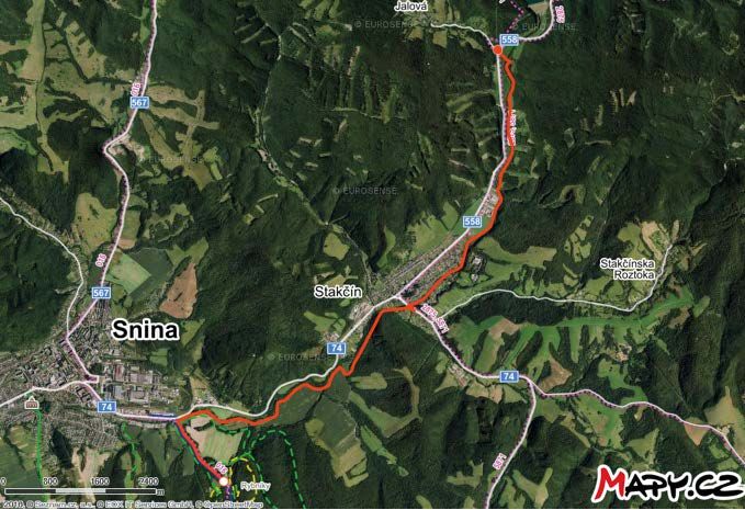
Snina to Stakčín to Starina variation, isolating the cyclist from motorized traffic on a route along
the Cirocha River (Figure 14). Ulič to Stakčín (Figure 15) through various existing forestry roads.
Half of this route is part of the 2019 ‘1,000-Mile Adventure Race’ (Ulič to Kalná Roztoka). Nová
Sedlica—Uličske Krivé (Figure 16): A sport cycling route with modest elevation inclines, offering
scenery and immersion in forests. Veľká Poľana—Ruské (Figures 17 and 18): an equestrian path,
could also serve as a cycling route for the sport cyclist seeking lookout points at higher elevations.4
FIGURE 15 Map of Ulič to Stakčín through various FIGURE 16 Nová Sedlica — Uličske Krivé: a sport
existing forestry roads. cycling route.
Distance: 28.17 km Altitude profile: 721 m 718 m Distance: 12.51 km Altitude profile: 537 m 647 m
240 m.a.s.l. 689 m.a.s.l.
7 km 14 km 3.1 km 6.3 km
30 Due Diligence Report on the Establishment of a Poloniny National Park TrailFIGURE 17 Map of Veľká Poľana to Ruské variation FIGURE 18 Veľká Poľana — Ruské: an equestrian
connecting with the path to Hodošik. path that could also serve as a cycling route.
Distance: 8.316 km Altitude profile: 352 m 265 m Distance: 13.09 km Altitude profile: 446 m 349 m
393 m.a.s.l. 369 m.a.s.l.
2.1 km 4.2 km 3.3 km 6.5 km
Map in Figure 19 illustrates the entire marked cycling routes in the Snina / Poloniny region. As stated,
the vast majority share the road with motorized traffic, except for a few sections mentioned pre-
viously. These routes are low traffic (generally accepted as less than 1,000 vehicles per day for the
Prešov Region). An adventure travel destination seeks to provide experiences that require some
physical input and are not readily accessible through common modes of transportation. The PPT
could be an attractive destination for adventure travelers, such as bike-packers and classic cycle
tourers, who would spend more than one day in the park with the implementation of appropri-
ate infrastructure, such as overnight shelters, accommodations, food establishments, and other
amenities. Furthermore, the PPT would only bolster the existing cycling network by providing var-
ious outlets for themed excursions, such as the IKON trail.
FIGURE 19 Map of all marked cycling routes FIGURE 20 Start of Porta Rusica leading up to
in Snina/Poloniny Ruské Sedlo, the border between Poland and the
Slovak Republic
Source: Peter Bujňák
Existing and Proposed Trail Network by Activity 31HIKING
The Snina Action Plan reports that the district offers 152.5 kilometers of marked hiking trails
among 12 routes, which are maintained and marked by the Humenné branch of the 20,000-mem-
ber nonprofit Club of Slovak tourists (KST). There are around 125 kilometers of marked hiking
routes within and around the national park, with some routes leaving the park and ending in vil-
lages near the park. The trails pass through and/or connect every village in Poloniny, as well as the
towns of Snina, Stakčin, and other communities in the district. In addition, some of the trails
could also be used for horseback riding.
One of the highlights of the marked hiking trails is that nearly 40 kilometers are along the ridge
of the Poloniny mountains, where more than 50% of the marked trail passes through the primor-
dial forests, or above them on the Poloniny fields. Some of the forests are designated UNESCO world
heritage sites and biosphere sites. All of them are part of the Slovak Republic’s national natural
reserves and natural reserves that have been accorded the fifth level of environmental protec-
tion. However, there are certain areas such as Havešova or Kycera, which also have great appeal,
as they are part of the natural reserves list, yet have no marked hiking trails nearing these areas.
The recommended Poloniny trail seeks to incorporate a hiking route variation passing the bor-
ders of these areas, but not running directly through them.
Hiking trails are well marked on available paper maps from manufacturers such as, ShoCart and
VKU Harmanec, as well as on mobile applications such as MAPY CZ. Hiking trail markings in the
actual park can be problematic depending on the area. Trail markers on trails passing through
areas with logging activity have been reported to be poorly marked, due to instances of trees being
cut containing the marker or damaged signs, (in this case, the route to Giglovo military cemetery
outside the park grounds within the Snina area near Sninské Rybníky was observed during trail
inspections on June 7, 2019). The issue of trail marking and maintenance needs to be addressed
with the stakeholders, such as the NP Poloniny, KST, LPM Ulič, and other regional entities.
The hiking trail to Jarabá Skala, a nature reserve site, initially winds along a 7.7-kilometer for-
est road where occasionally logging trucks pass by, but then the trail veers off the main logging
road and into the forest for the remaining two kilometers, before reaching the top of the ridge.
The only main areas of interest along the route (which is also a main logging road) are:
1. The Honey Woman’s wooden monument, with a traditional wooden hut housing 80 bee-
hives. The monument is, in fact, a memorial to Žofia Maťašovská, who maintained the bee-
hives with her daughters as her husband worked in the logging industry.
2. The forestry lodge and lake is roughly 500 meters further along the route. The lake has the
potential to become a recreational area, if proper eco-remediation activity were implement-
ed, and terms and conditions agreed with the owner (LPM Ulič).
While these areas are major points of interest and could be more attractive, the route leading
up to these is long and monotonous, and even longer, if one continues to the intersection lead-
ing up to Jarabá Skala (after which, the visitor is finally immersed in the natural beauty of the
park). A possible rerouting or an added trail in the vicinity could address this portion of the trail,
by offering additional options. The current route (yellow marking) along the main logging road
could become a cycling path, or even a through path for motorized vehicles, with parking pro-
vided in the vicinity of the Honey Woman sculpture. Space is adequate, without extensive earth-
works needed. Measures for traffic regulation, capacity, and fees need to be addressed to prevent
any environmental damage or encroachment. Existing road infrastructure is of a sufficient qual-
ity, with only minor improvements needed to create a visitors’ parking area, alongside a potential
recreational outlet in the Honey Woman and lake vicinity. This option would enable more favora-
ble excursions for tourists hiking up to Jarabá Skala and continuing along the ridge of Poloniny.
32 Due Diligence Report on the Establishment of a Poloniny National Park TrailYou can also read