Department of Environment, Great Lakes, and Energy Water Resources Division Michigan Coastal Management Program Section 309 Assessment and ...
←
→
Page content transcription
If your browser does not render page correctly, please read the page content below
Department of Environment, Great Lakes, and Energy
                 Water Resources Division

                    Michigan Coastal Management Program

      Section 309 Assessment and Enhancement Strategy,
                         2021-2025
                                                   January 22, 2021

EGLE Environmental Assistance Center 800-662-9278 Michigan.gov/EGLE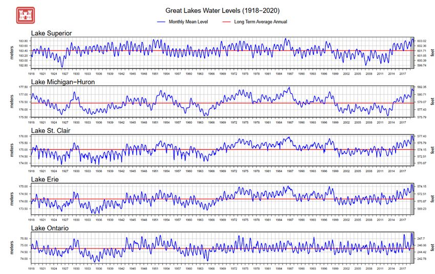
Michigan Coastal Management Program
                    Section 309 Assessment and Enhancement Strategy
                                       2021-2025

                                                    Table of Contents

I.     Background............................................................................................................ 3

II.    Summary and Achievements to date on the MCMP 2016-2020
       Coastal Geophysical Properties and Resiliency Enhancement Strategy …….6

III.   Phase I Assessment Findings .............................................................................. 9

         A.   Wetlands ......................................................................................................... 9
         B.   Hazards ......................................................................................................... 17
         C.   Public Access ................................................................................................ 27
         D.   Marine Debris ................................................................................................ 31
         E.   Cumulative and Secondary Impacts .............................................................. 34
         F.   Special Area Management Planning ............................................................. 38
         G.   Ocean and Great Lakes Resources .............................................................. 39
         H.   Energy and Government Facility Siting ......................................................... 48
         I.   Aquaculture ................................................................................................... 55

IV.    Phase II Assessment Findings and Management Priorities ............................ 59

         A.   Wetlands ....................................................................................................... 59
         B.   Hazards ......................................................................................................... 63
         C.   Public Access ................................................................................................ 70
         D.   Cumulative and Secondary Impacts .............................................................. 74

V.     2021-2025 MCMP Enhancement Strategies ....................................................... 78

         A. Coastal Leadership Academy ........................................................................ 78
         B. Resilient Coastal Communities Adaptation Strategies Toolkit ....................... 81

         Appendix
         A. Stakeholder Engagement Survey…………………………………………………87
I. Background
Within the Department of Environment, Great Lakes, and Energy (EGLE), Water Resources
Division (WRD), the Coastal Management Program Unit (CMPU) administers the Michigan
Coastal Management Program (MCMP). The MCMP’s mission is to protect, preserve, restore,
enhance, and wisely develop the coastal natural resources and cultural heritage on the longest
freshwater coastline in the nation. The MCMP is part of the national program established in
1978 as a state-federal partnership. The national program consists of 34 coastal states,
islands, and territories in coordination with the National Oceanic and Atmospheric
Administration (NOAA), Office for Coastal Management (OCM), Stewardship Division, Coastal
Communities Program.
The MCMP is a networked program established on three foundations, as outlined in the
Michigan Coastal Management Program and Final Environmental Impact Statement, July
1978: (1) Improve the administration of existing shoreland statutes; (2) Provide substantial
technical and financial assistance to local partners for creative coastal projects; and
(3) Improve the governmental coordination to reduce time delays, duplication, and conflicts in
coastal management decision-making, otherwise known as federal consistency.
The WRD's Field Operations Support Section (FOSS) is responsible for the effective
administration of the permitting and compliance activities within the designated MCMP coastal
boundary. The MCMP coastal boundary, generally, is defined as 1,000 feet landward of the
ordinary high-water mark. The coastal boundary also encompasses coastal inland lakes and
other critical ecosystems. The FOSS provides technical assistance and regulatory oversight
over activities such as dredging or filling of wetlands; and building in designated critical dune
areas, environmental areas, coastal wetland, or coastal floodplain in the following programs:
Part 31, Water Resources Protection; Part 301, Inland Lakes and Streams; Part 303, Wetlands
Protection; Part 323, Shorelands Protection and Management; Part 325, Great Lakes
Submerged Lands; and Part 353, Sand Dunes Protection and Management; of the Natural
Resources and Environmental Protection Act, 1994 PA 451, as amended (NREPA).
The CMPU is committed to providing substantial technical assistance and strategic grant
funding to assist stakeholders’ ability to understand risks and options to mitigate coastal
hazards; create healthy habitats that provide for human use and enjoyment; support coastal
eco-tourism while ensuring safe public access; and support resilient and sustainable coastal
economies. As connectors and collaborators, the MCMP advances the research on the effects
of a changing climate and resilient planning methods and seeks a balanced approach to a
sustainable coastline with the main objective to connect people and communities to the Great
Lakes coast. The federal consistency review duties are also administered within the FOSS
and are closely coordinated with the CMPU.
Section 309, Coastal Zone Enhancement Grants, of the Coastal Zone Management (CZM) Act
(Title 15 of the Code of Federal Regulations, Part 923, Coastal Zone Management Program
Regulations, Subpart K, Coastal Zone Enhancement Grants Program) establishes a voluntary
enhancement program for coastal states, territories, and islands with federally approved
coastal management programs to continually improve its programs in specific areas of national
3importance. Under the provisions of Section 309, NOAA, OCM encourages coastal programs
to strengthen and improve their programs on five-year cycles by conducting self-assessments
in the nine enhancement areas. The enhancement areas include wetlands; coastal hazards;
public access; marine debris; cumulative and secondary impacts; special area management
planning; ocean/Great Lakes resources; energy and government facility siting; and
aquaculture. Guided by the assessments, the MCMP identifies high priority issues and gaps
the program should address through strategies approved by NOAA, OCM. States with
approved assessment and strategies are eligible for financial support provided under Section
309.
Stakeholder Engagement Survey
The CMPU launched its MCMP Section 309 assessment process by conducting a stakeholder
engagement survey sent to over 300 local units of government, nonprofits, regional council of
governments, and university partners. The survey responses were primarily received from
local units of government (67%), followed by regional councils of government (17%), then by
nonprofits and academia (both at 8%). The survey responses overwhelmingly provided the
CMPU a clear “line in the sand” for the top enhancement areas to address which are listed in
the following order of importance:
1. Increase the understanding of risk and mitigation associated with coastal hazards, (e.g.,
erosion, flooding, and coastal storms).
2. Enhance public access for the use and enjoyment on Michigan’s coastline.
3. Protection, restoration, and preservation of coastal wetlands.
4. Development and adoption of procedures to assess, consider, and control cumulative
and secondary impacts of coastal growth and development.
The survey’s intent was to solicit opinions about coastal management priorities and needs to
help direct the MCMP’s work. The survey asked the following questions:
1. Describe your current or past working experience you have had with the MCMP.
2. Based on the MCMP mission statement, identify the top three areas that the MCMP
should mostly focus on.
3. Based on the top areas selected, what are the biggest challenges for each area?
4. What are the opportunities for the MCMP to more effectively address the challenges?
5. In what manner (e.g., technical assistance, trainings, outreach, research, or other) do you
see the MCMP best addressing the issues?
6. What are the biggest challenges facing coastal communities’ ability to be resilient?
7. Where do you see the MCMP role, or how could the program change or enhance itself, to
better support efforts to build coastal resiliency, adapt to climate change, or address other
coastal issues facing communities?
Responses to the question on experience with the MCMP was either as a past grant recipient
or none; while the responses to challenges varied, lack of funding and public awareness was
identified most often. With the question on what the MCMP can do to be more effective, a few
common responses highlighted the MCMP to provide as much information as possible to help
decision-making by delivering information and continuous education to local decision-makers,
4and by supporting applied research to better understand key coastal ecosystems. How the
MCMP would address the issues would be through training, outreach, and research.
The best summary response for the biggest challenges facing coastal communities’ ability to
be resilient was the lack of knowledge and professional staff to adequately identify
vulnerabilities and how the community would react and respond. The final question asked how
the MCMP could be enhanced to better support efforts to build coastal resiliency, adapt to
climate change, or address other coastal issues facing communities. The recommendation
was for the MCMP to provide public information meetings, ongoing funding support, training on
best practices and/or training that addresses resiliency, and template planning documents for
local communities.
The Engagement Survey report can be found in Appendix A.
Public Comment on Draft Assessment and Enhancement Strategy, 2021-2025.
The MCMP published the draft Assessment and Enhancement Strategy for a 30-day public
comment period on November 6, 2020. A comment received from an emergency
management administrator from a community that is situated outside of the MCMP coastal
boundary expressed that even though their city does not have direct impact on the coastline
there are still potential impacts to upland communities in the riverine/watershed systems.
From an emergency management perspective, additional analysis of the cumulative and
secondary impacts on how inland communities and the waterways are impacted by climate
changes and variations (e.g., highs and lows) of the Great Lakes water levels is needed.
As the Great Lakes water levels rise and fall combined with impacts of more intense and
frequent storm events, the effects are realized statewide; however, one must keep in mind that
coastal communities face a harsher reality of the “perfect storm”. That is, coastal communities
face far greater culminative and secondary impacts resulting from hydrology (e.g. quantity of
water in the system) from the upper watersheds as well as the impacts from coastal storms all
of which are being intensified at the coastline with the effects of climate change.
5II. Summary and Achievements to date on the MCMP 2016-2020 Coastal Geophysical
Properties and Resiliency Strategy
The NOAA, OCM approved the MCMP 2016-2020 Coastal Geophysical Properties and
Resiliency Strategy (Resiliency Strategy) on December 8, 2015, with the expectation of a
MCMP program changes. In part, the MCMP program change will be accomplished by the
creation of a technical guidance document targeting local decision-makers on the benefits of
developing resilient master plans and policies. The other program change will be sought
through a policy change proposed to WRD Management via an update to the WRD policy,
Considering Climate Change in WRD Programs, by identifying the technical guidance
document as an example of implementation of the policy.
The MCMP launched the Resiliency Strategy striving to learn what local decision-makers
understood for reducing risks to coastal hazards (erosion, flooding, and coastal storms) and
what to do to protect their coastline. Partnering with a project team of researchers and
community planning leaders, the MCMP is developing a program for applied research in
scenario-based planning methods, via pilot communities, and creating site-based data tools.
Research conducted to date in approximately eight pilot coastal communities suggests that
coastal communities are not directly planning for their coastal areas. Traditional scenario-
based planning methods are not incorporating coastal resource areas for protection nor
mitigation. Further, significant gaps exist with hazard-based (risk due to erosion and flooding)
data for the entire coast as well as community, site-specific areas.
Simplified decision-making approaches incorporating hazard-risk scenarios are developed to
help visualize what the “Expected – Lucky – Perfect Storm” may look like in community
planning through a range of physical conditions. These scenarios, along with model plan and
ordinance language, are being developed to increase the knowledge for local decision-makers.
Resulting hazard-ready Resilient Master Plans better align with the community’s vision for their
coast and help institutionalize management measures to adapt, accommodate, and ‘step back’
development from sensitive and dynamic coastal features.
For challenging questions such as, “How fast is the bluff eroding?” “What section of the coast
is most prone to flooding?” and “What might the beach look like in 30 years?,” the MCMP is
supporting the developent of a tool to look at those questions in an online “80-year” viewer
showing photographic evidence of beach and shoreline change. At a minimum, the coastal
change viewer provides local officials and property owners a first-hand view on the dynamic
nature of the coast over the long-term. The project team is furthering these efforts to provide a
coastal vulnerability index (CVI) within the viewer and to develop future-scenarios for coastal
erosion based on the information being developed and provided through the coastal change
viewer. This would allow communities to develop hazard-risk scenarios for coastal erosion in
addition to those that are currently being developed for coastal flooding.
The goal for the Resiliency Strategy is to develop policy and technical guidance targeting local
decision-makers that promotes hazard-ready coastal communities; communities that can
absorb and adapt to changes in Great Lakes water levels, coastal storms, and floods. Hazard-
ready communities provide space for beach and dunes to migrate naturally, so they can
6continue to serve the community, which includes functioning to absorb erosion and flooding
impacts.
Achievement to date:
• The MCMP partnered with Land Information Access Association (LIAA), Michigan
Technological University (MTU), and University of Michigan (UM) to directly engage with
eight pilot communities to date. The type of local program change is dependent upon the
local needs and views of each community and ranges from development of chapters for
prospective inclusion in future local master plans to updated master plans or ordinances
that incorporate coastal resilience principles. The pilot communities include the following:
1. City of Bridgman (Resilient Master Plan)
2. Bear Creek Township (Resilience Chapter)
3. Port Austin Township (Resilient Master Plan)
4. Port Austin Village (Resilient Master Plan)
5. Leland Township (Resilience Chapter)
6. Alpena County (Resilience Chapter)
7. Emmet County (Resilience Chapter)
8. St. Clair County (Resilience Chapter)
• The city of Bridgman serves as an example of local program enhancement through
improvements made within the community’s updated master plan. Bridgman’s updated
master plan includes an entire chapter on Planning for Coastal and Climate Trends,
along with an additional chapter on Defining Vulnerability in the Bridgman Community.
“Understand Coastal Processes”, “Understand Dune Dynamics,” and “Build Community
Resilience” were among the ten community-identified guiding principles for the master
plan. The plan lays the groundwork for future implementation advancements in the
community through the Goals and Actions Strategies chapter of the master plan which
includes the following:
o “Consider changing the setback on the Residential Lake District for Lake Michigan
fronting properties to more than 25 feet.”
o “Consider establishing an overlay district that would not allow for the placement of a
seawall or any other hardening along Lake Michigan.”
• Efforts in the remaining communities continue as the communities’ work towards
incorporating coastal hazards information into their planning and zoning actions in a
manner consistent with their local planning timelines and visions.
• A Coastal Change Viewer developed by MTU has been made publicly available at:
(http://geospatialresearch.mtu.edu/czmp). The viewer is a critical tool towards providing
insight on the dynamic nature of Michigan’s Great Lakes coast through time. The viewer
shows Great Lakes shoreline and bluff line (where applicable) movement through time
with data going back to 1938. Aerial imagery through time is included along with the
7digitized shorelines and bluff lines. The viewer is complete for Michigan’s lower peninsula
Lake Michigan and Lake Huron shorelines.
• LIAA is facilitating programs referred to as Navigator Training that provide a broad
overview of coastal dynamics, resilience planning, and how changes in climate and Great
Lakes water levels are impacting communities. In addition, the training programs provide
an overview of scenario-based planning tools and how planners and local officials can
use coastal hazards data to inform local planning.
• A series of white papers have been developed by the UM to inform coastal resilience
planning:
o “Overlooking the Coast: Limited Local Planning for Coastal Area Management along
Michigan’s Great Lakes.” This paper provides an evaluation of local efforts to
manage Great Lakes coastal shorelands through master plans, focusing on
Michigan localities. Findings showed that Michigan communities were largely failing
to consider coastal areas and dynamics in their planning. The paper also finds that
having knowledge about coastal dynamics appears important in explaining local
planning efforts, but having the capacity to act on that knowledge and the
commitment to do so are equally or more important.
o “Using Simple Decision-Centered Scenario-Based Planning to Integrate Coastal
Hazard Management into the Master Plans of Small Great Lakes Communities.”
Presents methods for applying scenario-based planning to coastal hazards
mitigation. The paper also provides findings and observations from participatory
action research (PAR) of selected Great Lakes coastal communities where these
scenario-based planning approaches were applied.
o “Local Zoning in Michigan for Great Lakes Coastal Shoreland Management Initial
Findings and Guidance.” This paper presents a preliminary review of zoning
ordinance provisions that coastal communities might adopt to improve their
management of coastal hazards. This review primarily occurred in the northwest
region of the Lower Peninsula.
• The MCMP’s 2019 Project of Special Merit is working in collaboration with the Michigan
Association of Planning (MAP) to develop technical training to implement the MCMP
technical guidance document with a flipped classroom format. The MCMP has worked
with the Michigan Sea Grant (MSG) to develop a six-video series outlining the path to
community resilience. The videos will be housed on the EGLE MCMP Resilient Coast
webpage as well on the partners websites in an effort of strategic messaging.
8III. Phase I. Assessment Findings
The MCMP completed a high-level analysis of the nine enhancement areas following the
NOAA Section 309 guidance. The following section outlines the assessment findings.
A. Wetlands
Section 309 Enhancement Objective: Protection, restoration, or enhancement of the existing
coastal wetlands base, or creation of new coastal wetlands. §309(a)(1).
Note: For the purposes of the Wetlands Assessment, wetlands are “those areas that are
inundated or saturated at a frequency and duration sufficient to support, and that under normal
circumstances do support, a prevalence of vegetation typically adapted for life in saturated soil
conditions.” [33 CFR 328.3(b)].
Resource Characterization:
Great Lakes coastal wetlands offer recreational and tourism opportunities in addition to a
variety of beneficial ecological services. Coastal wetlands are well known for serving vital
functions such as providing wildlife habitat and improving water quality, but coastal wetlands
are equally valuable as natural barriers to slow waves and storm surges through friction and
providing flood storage and control functions.
Based on the processing of 2016 NOAA’s C-CAP Coastal Land Atlas raw data utilizing a
wetland modeling tool developed by MCMP staff to analyze the data, it was calculated that
Michigan currently has 5,304,199 acres of coastal wetlands within the MCMP coastal counties,
and 351,603 acres within its coastal boundary. The following table indicates the latest status
and trends for Michigan’s coastal wetlands from 1996 to 2016 and from 2010 to 2016.
Coastal Wetlands Status and Trends (Coastal Counties)
Current state of wetlands in 2016 (acres) 5,304,199
Percent net change in total wetlands (% from 1996-2016 - 0.52% from 2010-2016 - 0.03%
gained or lost)
Percent net change in freshwater (palustrine from 1996-2010 - 0.52% from 2010-2016 - 0.03%
wetlands) (% gained or lost)
Percent net change in saltwater (estuarine) from 1996-2016 - N/A from 2010-2016 - N/A
wetlands (% gained or lost)
Table 1: Coastal Wetlands Status and Trends (Coastal Counties)
The following tables report the coastal wetlands status and trends within the MCMP coastal
boundary.
9Coastal Wetlands Status and Trends (Coastal Boundary Management Program)
Current state of wetlands in 2016 (acres) 351,603
Percent net change in total wetlands (% from 1996-2016 - 4.20% from 2010-2016 - -0.22%
gained or lost)
Percent net change in freshwater (palustrine from 1996-2016 - 4.20% from 2010-2016 - -0.22%
wetlands) (% gained or lost)
Percent net change in saltwater (estuarine) from 1996-2016 - N/A from 2010-2016 - N/A
wetlands (% gained or lost)
Table 2: Coastal Wetlands Status and Trends MCMP
As previously reported in the last 2016-2020 Assessment, the state has a more detailed
wetland inventory then what is provided in NOAA’s C-CAP Coastal Land Atlas. The State’s
wetland inventories were produced on a county-by-county basis, all in the same manner and
integrated into the U.S. Fish and Wildlife Service (USFWS) National Wetlands Inventory (NWI)
datasets. The wetland datasets can be viewed as maps in NWI Wetlands Mapper and EGLE’s
online Wetland Map Viewer. The state is currently updating the inventory, but the latest
inventory to be completed and integrated in into the NWI Wetlands Mapper and EGLE’s online
Wetland Map viewer occurred in 2005. Because of this reason, the latest dataset for C-CAP
data (2016) was used to estimate coastal wetland acreage in the state.
The following table provides the changes in the number of wetlands in square miles converted
to developed land, agriculture, barren land, and open water from 1996-2016 when the data
was first collected, and 2011-2016 and since the 2015 assessment.
Land Cover Type Area of Wetlands Transformed Area of Wetlands Transformed
to Another Type of Land to Another Type of Land Cover
Cover Between 1996-2016 (Sq. Between 2011-2016 (Sq. Miles)
Miles)
Development 6.43 0.50
Agriculture 6.18 1.66
Barren Land 4.54 0.64
Water 13.54 9.01
Table 3: How Wetlands Are Changing
In 2016 , the MCMP partnered with the UM, MTU, Michigan Technological Research Institute
(MTRI), and LIAA, to develop the methodology to map coastal wetland zones of dynamic
coastal influences (ZDCI). The ZDCI refined the distinction between lands inundated and
wetlands that are hydrologically connected through inundation. The UM, MTU, and MTRI
incorporated the calculations, mapping, and information from the Great Lakes Aquatic Habitat
Framework (GLAHF) into the ZDCI for all of the 41 Lower Peninsula coastal counties. The
information from each county was based on vegetation maps, Digital Elevation Models
(DEMs), and county elevation data developed by MTU and MTRI. UM also incorporated the
modeled connectivity data developed by MTRI and the high, low, surge, and wave-run-up
water levels developed by MTU. Using all of this information, UM developed a page on the
10GLAHF Web site (https://www.glahf.org/coastal-wetlands/) for all data on coastal wetlands and
an interactive Coastal Wetlands Explorer for viewing the delineated coastal wetland
boundaries. The boundaries can be viewed by type or the alternative ZDCIs, which enables
users to zoom in on a given location and manipulate the data layers to be included for various
types of mapping and/or downloading formats. UM also developed printable county maps that
include the two different versions of ZDCIs (i.e., geomorphic and elevation) with modeled
connectivity capabilities.
This work resulted in the creation of spatial predictions of coastal wetlands in the Lower
Peninsula of Michigan; but creation of spatial predictions for coastal wetlands and the ZDCI is
needed for the Upper Peninsula for communities that border Lake Superior and the upper
sections of Lake Michigan and Huron. Since the completion of the project in 2018, the MCMP
is not aware of plans to conduct additional work to complete maps for the upper peninsula.
An important outcome of this work is the methodology used to develop rapid wetland
connectivity maps that can be easily applied to other coastlines using hydrological modeling
and DEMs, rather than through time-intensive image interpretation. By identifying where
wetlands in Michigan’s Lower Peninsula are hydrologically connected to Great Lakes waters
and consequently assess what land areas are periodically inundated by Great Lakes water, the
analyses reveal that connected wetlands are concentrated on the eastern side of Michigan’s
Lower Peninsula. During average water levels, 96% of the connected wetlands in Michigan’s
Lower Peninsula are predicted to be along the shores of Lakes Huron, St. Clair, and Erie. The
data could help local decision-makers understand where coastal wetlands are located and
whether they are connected directly to the Great Lakes waters at varying levels. This
information could be utilized by the MCMP as part of efforts to assist communities with
developing vibrant, healthy, and resilient coastal communities through preservation, protection,
restoring, and enhancing healthy coastal ecosystems.
The ZDCI was designed to inform local decision-makers of the land areas influenced by Great
Lakes waters. The data layers are intended to identify the distinctions between lands
inundated generally and wetlands hydrologically connected to the Great Lakes through
inundation. The data layers help local governments and decision-makers improve shoreland
management and enhance resiliency by adopting policies that restrict development in areas
influenced by Great Lakes waters and provide wetland inventories that can be utilized in
recreational or other community plans. Since the project completion, the MCMP is unaware if
any related outreach has occurred, but the final report and maps are posted on the GLAHF
Web site as identified above.
Management Characterization:
Revisions to the state statute Part 303 of the NREPA, occurred 2019. Senate Bill 1211 (now
PA 631 of 2018) went into effect on March 28, 2019. These changes amended the following
sections of the NREPA: Part 13, Permits (details requirements and processes for permit
application, review, approval or denial, and petitioning a permit decision; applies to all divisions
who engage in NREPA permitting; Part 15, Enforcement (details enforcement authorities and
procedures required under the NREPA, including those related to civil enforcement action),
11Part 301, Inland Lakes and Streams (regulates inland lakes and stream activities as defined
under statute), and Part 303, Wetlands Protection (regulates wetland activities as defined
under statute). Overall, the amendments did not result in major changes, but add
requirements on the WRD to document decisions and consider federally defined Waters of the
United States (WOTUS) when determining jurisdiction.
Minor modifications were also made to other enforcement and permitting processes. It is
unlikely that the new amendments made by PA 631 of 2018 deregulate wetlands, lakes, or
streams. WRD has the Wetland Identification Program and pre-application services available
to assist the public in identifying whether there are regulated wetlands on their property.
Though the changes are not significant, they require minor modifications to Part 303.
Below is a summary created by WRD for the public on the changes in PA 631 that impact
Part 303, which should be used in conjunction with the language provided in the new
amendments as follows:
• Part 13 and Part 15 Changes: Requirements were added for the specific documentation
needed by EGLE for permit approvals with modification, denials, and civil enforcement
actions under Part 301 and Part 303.
• Part 301 and Part 303 Definitions.
o The main definition of inland lakes and streams remains the same.
o The main definition of wetland has been reworded, but the meaning remains
the same. However, the amendments add artificial or natural lakes, ponds, or
impoundments and wetlands that are a WOTUS under the federal Clean
Water Act.
The language allowing non-contiguous wetlands less than five acres in size to be regulated if
determined to be essential to the preservation of the natural resources of the state has been
removed. However, language was added regulating wetlands with the documented
presence of state or federal endangered or threatened species and wetlands that are rare
and imperiled.
o Other Definitions Changes:
▪ The definition of hydric soil from the federal delineation manual and
regional supplements which are already in use in Michigan was added.
▪ The list of rare and imperiled wetlands was modified.
▪ Farm or stock ponds constructed consistent with the exemption under
30305(2)(g) are now not considered ponds for the purposes of the
definition of “contiguous.”
▪ Voluntary wetland restoration definitions were added to make the bill
consistent with the recently passed bills on voluntary wetland restoration.
These new definitions do not apply to other sections of the statute (i.e., the
definitions should not be used outside of voluntary wetland restoration project
reviews).
12o Other Amendments:
▪ Language was added clarifying that borrow material for farm and forest
road construction and maintenance be taken from upland sources if
feasible.
▪ The amendments remove mention of restoration orders and allow WRD to
determine whether they accept an after-the-fact permit application on a case-
by-case basis.
▪ The requirement to create a bi-weekly list of applications has been removed,
and language that already occurs in Part 301 referring to Web site postings
has been added.
▪ Additional language regarding entering the premises for inspections has
been added.
▪ The amendments provide that reasonable expert professional witness fees,
as determined by the court or an administrative law judge, must be awarded
to a landowner that prevails against the WRD on whether the landowner’s
property is a wetland.
The WRD participated in the Coastal Conservation Work Group which was developed under
the Upper Midwest and Great Lakes Landscape Conservation Cooperative (LCC) which
focused its efforts on the Saginaw Bay to Western Lake Erie region. The LCC has since lost
funding. However, the partners within the Coastal Conservation Work Group wanted to keep
the workgroup together and formed the Great Lakes Coastal Assembly (Coastal Assembly).
The WRD is a partner in the newly formed Coastal Assembly which has expanded its
membership to include representatives from other Great Lakes states and Canadian
government. The assembly has several purposes: to promote collaborations aimed at
management, restoration, and conservation of coastal areas; to assist organizations in
assessing where investments should be made, and how to align them with regional, state, and
local goals; to identify needs for science and decision support data and tools; and to enable
actions that help coastal managers make effective decisions.
The main goal of the WRD’s Wetland Assessment and Monitoring Program is to assess the
State’s effectiveness in protecting, managing, and restoring Michigan’s wetlands that have
public benefits as defined under Part 303 of the NREPA. WRD developed the State of
Michigan Wetland Monitoring and Assessment Strategy (Wetland Strategy) which includes
landscape level, rapid and intensive wetlands assessment methods, and statewide monitoring
goals, and was finalized in March of 2015.
To meet the goals of the Wetlands Strategy, the Wetland Assessment and Monitoring Program
is tasked with implementing the monitoring objectives outlined in the strategy. These include
updating the inventory of Michigan’s wetland resources by gathering and analyzing geographic
information system remote sensed data, updating the National Wetland Inventory maps,
applying Landscape Level assessment on a watershed scale, and using the Rapid assessment
Method to assess wetland functions and values, regardless of ecological type.
Since 2015, the WRD received funding from various sources including U.S. Environmental
Protection Agency (USEPA), Renew Michigan Fund (state funds designated for critical
13upgrades to road and water infrastructure and environmental improvements), Southeast
Michigan Council of Governments, and USFWS to conduct inventory of Michigan’s wetland
resources. Kent and Washtenaw counties were completed using funds from USEPA; 12
southwest/central counties (including three coastal counties, Allegan, Van Buren, and Berrien)
are in progress and being funded by Renew Michigan Fund; six southeast counties ( including
four coastal counties, St. Clair, Macomb, Wayne, and Monroe) are in progress and being
funded by Southeast Michigan Council of Governments; and in the Upper Peninsula, wetland
inventories funded by USFWS are in progress for two watersheds. One watershed is located
in Marquette, Alger, and Delta counties, and the other is located in Schoolcraft, Luce, and
Mackinac counties. In 2020, wetland inventory of 29 counties centrally located in Michigan
between Lake Michigan and Lake Huron (including eight coastal counties, Mason, Oceana,
Muskegon, Ottawa, Bay, Tuscola, Huron, and Sanilac) will commence. Renew Michigan
funding will be used to complete the inventory for these counties.
Since the Wetland Strategy was finalized, WRD has conducted Level 3 Intensive Site
Assessment used in part to refine and verify the rapid wetland assessment method to
diagnose the cause of wetland degradation (Level 3 Assessment). In 2016, the WRD
partnered with the USEPA to conduct Level 3 Assessments on 19 sites, part of the USEPA’s
National Wetland Condition Assessment efforts to assess wetland functions and values. The
sites were randomly selected using USFWS Status and Trends Plots. Since 2016, the WRD
received additional funding and randomly selected 83 sites where permission was obtained
from the landowner to conduct the site assessments. This resulted in assessments being
conducted on state lands. Of the 83 sites randomly selected, less than five were located within
the coastal boundary. A total of 100 sites were assessed. It is anticipated that the
assessment data from these 100 sites will be incorporated into the online Wetland Map Viewer
in 2020.
The WRD participates in the Great Lakes coastal wetland monitoring project funded by the
Great Lakes Restoration Initiative led by Central Michigan University (CMU) in partnership with
various U.S. and Canadian universities and federal agencies, private and nonprofit
organizations. WRD’s role included facilitating the communication between researchers and
agencies participating in the project. The Great Lakes Coastal Wetland Monitoring Program
was initially a five-year monitoring project based on a study developed by the Great Lakes
Coastal Wetlands Consortium in 2008. The monitoring project timeframe was initially from
2010 to 2015, but in 2015 another $10 million in funding was received to continue for the next
six to 10 years.
The goal of this project is to monitor the conditions and trends of every coastal wetlands within
the Great Lakes basin. Approximately 1,039 acres of coastal wetlands that are greater than
four hectares in size and have a surface water connection to the Great Lakes are being
monitored after five years. Data gathered at each site included information on birds,
amphibians, fish, invertebrates, plants, water quality and habitat. The Great Lakes Coastal
Wetland Monitoring Program continues to lead the basin-wide monitoring efforts of Great
Lakes coastal wetlands and continues to work on updating the coastal wetlands polygons
(e.g., geographic representation of a wetland area) that are currently being used in the Site
Mapping and Great Lakes Coastal Wetlands Decision Support Tools hosted by CMU (Decision
14Support Tool). The Decision Support Tool was initially developed for Saginaw Bay, Lake St.
Clair, and Western Lake Erie, but through funding provided by the MCMP, the geographic area
for the tool was expanded to cover all of Michigan’s coastline. The link to the wetland
monitoring reports/publications, Site Mapping and Decision Tools, can be found on the CMU
Web site located at (https://greatlakeswetlands.org/Home.vbhtml).
This platform and information is available to researchers, state wetland managers, and local
decision-makers to help guide restoration and conservation efforts in Michigan. This is a tool
that the MCMP can utilize to meet its strategic goal of ensuring Michigan’s coastal habitats are
protected, preserved, and restored for use and enjoyment of Michigan’s citizen’s and visitors
by providing technical assistance to coastal communities.
Management Category Significant Changes Since Last Assessment
(Y or N)
Statutes, regulations, policies, or case law N
interpreting these
Wetlands programs (e.g., regulatory, migration, N
restoration, acquisition)
Table 4: Significant Changes in Wetland Management
The program change achieved as a result of the Section 309 Assessment and Five-Year
Strategy for CZM Program Enhancement Fiscal Years 2012-2016, Strategy: Climate Change
Adaptation in Coastal Wetland Management, the WRD adopted an internal climate change
adaptation policy WRD-046, Considering Climate Change in Water Resources Division
Program on February 12, 2016. The WRD-046 policy states that “The WRD should consider
the impacts of climate change and aim to implement adaptation and mitigation measures
within its programs in an effort to minimize the degradation and impairment of the state’s water
resources due to climate change.”
Enhancement Area Prioritization:
1. What level of priority is the enhancement area for the coastal management program?
High
Medium
Low
2. Briefly explain the reason for this level of priority. Include input from stakeholder
engagement, including the types of stakeholders engaged.
The majority of the respondents indicated that the protection, restoration, and preservation of
coastal wetlands was identified as one of the top three areas that the MCMP should focus its
effort on. Survey participants indicated that the biggest challenges specifically to wetlands
included in part: identification, delineation of boundaries and regulating wetlands;
implementation of public policy that supports wetland protection and not impacts; MCMP
15funding is generally too small to leverage large-scale projects, and can’t be used as match with
other federal funding sources; public awareness of the issues; convincing people to value
natural resources and to think of them as finite; and number of threats, including better
understanding of impacts of the changing water levels, and how different types of development
impact different types of coastal ecosystems.
When participants were asked what the opportunities for MCMP were to more effectively
address the changes, the overall response was to provide more information and public
outreach. Specifically, participants indicated development of key messages to the public on
the importance of coastal wetlands, including functions, values, and priority conservation
opportunities.
As described in the Status and Trends of Michigan’s Wetlands: Pre-European Settlement to
2005 developed by WRD and finalized July 2014, Great Lakes coastal wetlands are among the
most biologically diverse ecosystems in Michigan. It was reported that “Michigan’s wetlands
continue to face increasing threats, including historic threats such as agriculture and
development, as well as new threats like invasive species and climate changes.” Additionally,
coastal wetlands are also impacted by the variability of the Great Lakes water levels. These
threats continue to be stressors on the health of coastal wetlands.
WRD continues to conduct wetland monitoring and assessment work state-wide as funding
becomes available. The monitoring of coastal wetlands that are greater than four hectares in
size and have a surface connection to the Great Lakes by CMU and its partners has significant
funding by the Great Lakes Restoration Initiative. However, there continues to be a data gap
on monitoring on coastal wetlands that is less than four hectares. Future funding mechanisms
need to be identified or state programs developed to increase the number of the coastal
wetlands monitored by the State to have a better understanding of the health and function of
all coastal wetlands as management efforts are focused on addressing the above-mentioned
stressor. This is especially important as Great Lakes water levels are predicted to remain
higher for the foreseeable future.
Development of adaptive management measures is needed to assist coastal communities with
resiliency efforts to preserve and protect these important ecosystems. Coastal wetlands are
dynamic systems that are subject to high-water levels and the associated erosive forces along
with low water levels. Communities need to consider these changing water levels as part of
their planning process.
As indicated above, another gap needed to be addressed is the completion of the creation of
spatial predictions for coastal wetlands and the ZDCI for the Upper Peninsula, specifically for
communities that border Lake Superior and the upper sections of Lake Michigan and Huron.
Completion of these datasets are needed to ensure all coastal communities have this data
when considering it short-term and long-term planning goals and strategies.
Given the status and trends for coastal wetlands within the coastal boundary, program gaps,
and stakeholder engagement perspectives as described under Section III. Stakeholder
Engagement (a complete list of the stakeholders and survey response are in Appendix 1), the
MCMP rates Coastal Wetlands as a High Priority Enhancement Area. Invasive species,
16development pressure and conversion to agriculture, and great lakes water levels continue to
have an impact on coastal wetlands. Coastal wetlands serve a vital function as habitat for
plant and wildlife species and provide a wide variety of ecosystem service for communities
including maintaining water quality, providing recreational opportunities, flood storage, and
erosion control. In order to achieve on-the-ground changes that protect, restore, and enhance
coastal wetlands, coastal communities need to be empowered to take the necessary steps by
strengthening their commitment and capacity to address the challenges that impact wetlands.
To do this, coastal communities need to have the resources and tools to guide them towards
long-term resilience planning, including the implementation of restoration and enhancement
resilient options.
B. Coastal Hazards
Section 309 Enhancement Objective: Prevent or significantly reduce threats to life and
property by eliminating development and redevelopment in high-hazard areas, managing
development in other hazard areas, and anticipating and managing the effects of potential sea
level rise and Great Lakes level change. §309(a)(2).
Note: For purposes of the Hazards Assessment, coastal hazards include the following
traditional hazards and those identified in the Coastal Zone Management Act (CZMA):
flooding; coastal storms including associated storm surge; geological hazards (e.g.,
tsunamis, earthquakes); shoreline erosion including bluff and dune erosion; Great Lake
level change; and land subsidence.
Resource Characterization:
The Great Lakes are experiencing the highest water levels since 1986, and storms and wave
action are causing significant erosion and flooding along Michigan’s coast. Great Lakes water
levels are cyclical with periods of low and high-water, with each period lasting for several years
depending on the relative amount of precipitation, runoff, and evaporation.
At the time of the previous Section 309 assessment efforts, water levels were just beginning to
rise after an approximate 15-year low stand (see Figure 1). During the low water period,
entrance harbor shoaling occurred impacting shipping and recreational boating; marina docks
were so high above the water surface that they were unusable in some cases; and beaches
expanded. In many cases the expanding beaches prompted new pressures for development
situated further lakeward.
The rise in Great Lakes water levels that began in 2013 was the fastest on record. In 2019, all
the Great Lakes were at least a foot higher than their long-term average water levels. Water
level projections for 2020 anticipate the lakes will be similar to those elevations in 2019. Lakes
Michigan and Huron are expected to exceed their annual levels to a greater degree than the
other lakes, which is problematic due to the high level of development along the Michigan and
Huron coasts.
17During high-water periods Michigan’s coast experiences, a variety of challenges, which in large
part relate to the local shoreline type. Michigan’s diverse coastal geomorphology is displayed
through a wide array of shore types including dunes, bluffs, marshes, cobble, and hardground
shorelines. High-water may cause irreversible erosion of coastal bluffs threatening any bluff
top development by undermining, whereas in low-lying areas flooding will occur. One constant
that spans most shoreline types during high-water periods is the reaction of attempting to stop
the shoreline from moving through construction of engineered structures.
Figure 1. Great Lakes Water Levels: Year-to-Date, US Army Corps of Engineers
The table below indicates the general level of risk in the MCMP coastal boundary for various
types of coastal hazards.
18Type of Hazard General Level of Risk (H, M, L)
Flooding (riverine, stormwater) H
Coastal storms (including storm surge) H
Geological hazards (e.g., tsunamis, earthquakes) L
Shoreline erosion H
Sea level rise N/A
Great Lakes level change H
Land subsidence L
Saltwater intrusion N/A
Other – Dangerous currents including rip currents M
Table 5: Hazard Risk in the MCMP coastal boundary
Major stretches of Michigan’s coast are subject to flooding and erosion hazards. Great Lakes
level changes are explicitly identified as a hazard in the table above; however, impacts of such
changes are typically expressed as erosion and/or flood impacts during high-water events or
as shipping and recreation impacts during low water events. Michigan is not in an active
tectonic area and therefore tsunamis and earthquake impacts are not anticipated. Land
subsidence has not historically had a significant impact on coastal hazards along Michigan’s
Great Lakes shoreline. Due to isostatic rebound following the last period of glaciation in the
region, the land under the upper Great Lakes is rising relative to the lower lakes. This isostatic
rebound will result in relative changes in lake levels; however, the rate of change is occurring
so slowly that it does not constitute as a hazard.
High-water levels have resulted in recent, significant impacts along the coast during storm
events, including coastal erosion undermining homes, parking lots and other development, and
flood impacts to homes and other infrastructure along low-lying coastal areas. Examples of
the type of impacts experienced recently include:
• Roadways closed:
o The city of Muskegon - located along the central Lake Michigan shoreline - closed
Beach Street on Wednesday, September 25, 2019, because high-water and waves
were crashing up and over the roadway causing dangerous conditions. The street,
which is the primary road access to the city’s popular Pere Marquette Beach, is
expected to remain closed through the fall and winter.
o Lakeshore Boulevard – located along the Lake Superior shoreline in the city of
Marquette – was closed twice in the span of three weeks during September 2019
due to high waves crashing onto the roadway. Flooding and erosion are chronic
issues along this stretch. The city has been awarded a grant from the National Fish
and Wildlife Foundation that will support a managed-retreat effort to move the
roadway landward, out of harm’s way.
19• Homes flooded:
o The city of Luna Pier evacuated portions of the Allen’s Cove neighborhood along the
Lake Erie shoreline in April 2019 due to coastal flooding.
o The city of Detroit installed sandbags in the Jefferson Chalmers neighborhood along
the Lake St. Clair shoreline in July 2019 to reduce impacts from coastal flooding
along the Lake St. Clair Shoreline.
• Homes/structures impacted by coastal erosion:
o Great Lakes shorelands staff, WRD has begun maintaining an inventory of homes
and other structures imminently threatened by erosion. Twenty-one entries are
documented between 7/6/2014, and 10/22/2019. Three structures are listed as
demolished; six structures as relocated; and eleven as at-risk.
• Coastal tourism impacted:
o Flooding at Fishtown – This rare commercial fishing and popular tourist location,
located in Leland, along the northeastern Lake Michigan shoreline is suffering from
flooding impacts. Some of the historic waterfront shanties and businesses have
been flooded and local fundraising efforts are underway to elevate some of the
structures.
o Beach eliminated and historic structure threatened at Orchard Beach State Park –
Water is lapping at the toe of the bluff and no recreational beach remains at this
State Park, located along the North-Central Lake Michigan shoreline. An historic,
1940’s stone pavilion that sits about 50-feet from the top of the eroding bluff is
threatened. The Michigan Department of Natural Resources (MDNR) is working
with a consulting firm to identify options to save the structure and park lands.
Michigan’s recreational, public trust beaches have receded significantly in both width and
extent due to high-water levels, erosion, and increased use and effects from shore protection
structures. Reduced beach widths have an undetermined economic impact on property values
and coastal community tourism economies as well as providing decreased eco-system service
values due to a decreased ability to protect the upland from coastal storms.
Eroding beaches have resulted in a significant rise in installations of shore protection
structures, primarily in the form of shore-parallel revetments and seawalls. More than 500
permits for installation of shore protection were issued by EGLE, WRD in the first quarter of
2020. This is higher than the number of permits that would typically be issued during an entire
year.
Traditional harden shore protection structures temporarily halt erosion of coastal bluffs and
dunes; however, these structures also disrupt the supply of sand to beaches. The majority of
Michigan’s Great Lakes beach sand is derived from erosion of coastal bluff and dune systems
and therefore the halting of erosion of these bluff and dune systems exacerbates the problem
of a limited sand supply along our beaches. Beaches simply cannot be sustained when their
sand supply is cut off.
20Multiple efforts to better understand coastal hazards resource impacts, threats, and
vulnerabilities have been undertaken or are on-going. Following is a summary of these efforts:
• Great Lakes Coastal Flood Study: The Federal Emergency Management Agency (FEMA)
in partnership with the U.S. Army Corps of Engineers (USACE) is conducting a coastal
analysis and mapping study to update Digital Flood Insurance Rate Maps (DFIRMs) for
coastal counties along the Great Lakes. The mapping and analysis effort, which began in
2012, has resulted in new preliminary coastal flood maps for most Michigan coastal
counties. Implementation of the hazard areas depicted within the updated maps will be
rolled out on a county-by-county basis beginning in early 2020. The new flood risk
information will be used to increase understanding of local coastal flood risk, facilitate
mitigation efforts, and improve community resilience to Great Lakes flood events. For the
first time along Michigan’s coast, the updated Flood Insurance Rate Maps (FIRMs) will
identify Coastal High Hazard Areas, or VE zones. VE zones differ from other Special
Flood Hazard Areas in that they are exposed to powerful waves during large flood events.
These areas are therefore prone to increased risk of structural damage to buildings and
other infrastructure.
• Great Lakes Coastal Reporting Tool (https://superiorwatersheds.org/report-erosion-
hazard): The Great Lakes Coastal Reporting Tool provides an easy-to-use, web-based
portal for the public to provide, and view, information on coastal erosion, flood events, and
other shoreline impacts. The brief eye-witness reports and site photographs provide
valuable insight into coastal storm impacts and shoreline change over time. Superior
Watershed Partnership and Land Trust Developed the Tool for use within their coverage
area and therefore tool coverage is currently limited to Michigan’s Upper Peninsula coast.
• National Shoreline Management Study – Lake Michigan: The Institute for Water
Resources, USACE, in 2017, published the Lake Michigan report under the
Congressionally-authorized National Shoreline Management Study. Management
challenges for Lake Michigan that may be applied by policy makers, coastal engineers
and scientists, and other stakeholders to improve coastal resilience are reviewed. A
compilation of existing information summarizing characteristics such as: shoreline type
and processes; sediment management; impacts of water level variations, effects of
erosion, and shoreline governance is provided. Michigan’s Lake Michigan shoreline is
characterized in the report based largely on information from the WRD’s high-risk erosion
area (HREA) studies, a USACE Regional Sediment Management study in the early
2000’s, and the USACE’s Section 111 studies of the effects of navigation structures on
adjacent shorelines.
• Great Lakes Shoreviewer (http://www.greatlakesshoreviewer.org/): The Great Lakes
Shoreviewer (Shoreviewer) is a publicly accessible online mapping tool that includes
color, aerial photographs (vertical and oblique), slope and elevation information, as well
as preliminary mapping efforts to display vulnerability to erosion areas and steep slopes.
Shoreviewer was developed with MCMP support to the Superior Watershed Partnership
21(SWP) and partners at Applied Ecological Service (AES) and 906 Technologies, and can
assist coastal management, restoration, planning, and outdoor recreation.
• Historic Shoretypes in Michigan - Data Development: MCMP supported the Michigan
Natural Features Inventory’s 2018 project entitled Spatial Data to Improve Coastal
Resiliency and Better Inform Local Decision Making. Geospatial data layers showing the
extent and characteristics of coastal dune systems were developed along with a digital
layer showing an historic (circa 1950’s) inventory and assessment of Michigan’s Great
Lakes coastal geomorphology. The historic hardcopy (mylar) maps, known as the
Humphrys shoretype classification, were converted into a digital GIS data layer. Historic
beach and nearshore parameters such as beach width, slopes, sediment type, and
erosion potential qualifiers can help local communities better understand which areas
have had higher potential for shoreline erosion, potentially resulting in lower risk for new
developments within the coastal boundary, while also identifying potential risk to existing
infrastructure.
While beach erosion and coastal flood challenges are currently high-priority coastal hazards,
challenges associated with swimmer safety from dangerous nearshore currents continue to be
a concern. According to the Great Lakes Current Incident Database
(https://www.michiganseagrant.org/dcd/dcdsearch.php), since 2015 Michigan’s Great Lakes
waters have seen 15 fatalities and 55 rescues associated with dangerous nearshore currents.
The Great Lakes Dangerous Nearshore Currents Dashboard developed by researchers at
MTU, identifies stretches of the Lake Michigan and Lake Superior shoreline most prone to rip
currents and other dangerous nearshore currents. Application of a model to semi-
automatically detect and map geo-indicators for dangerous nearshore currents was applied to
a time sequence of aerial photographs. Mapping of dangerous nearshore current hot spots
through the dashboard informs beach managers and the public on the relative risk level
existing along any stretch of the mapped shoreline.
Management Characterization:
Coastal hazards management occurs at federal, state, and local levels of government. Private
landowners also serve as critical decision-makers with respect to development and
management of coastal ecosystems and hazards.
The tables and narrative below provide information on coastal hazards-related management
actions employed in Michigan along with changes since the last assessment as related to
changes in hazards statutes, regulations, policies, or case law; changes in hazards planning
programs or initiatives; and changes in hazards mapping or modeling programs or initiatives.
State statutes, regulations, policies, and case law have not significantly changed since the last
assessment; however, resource changes have affected implementation, especially with
respect to permits for construction of shore protection structures and coastal development in
regulated areas.
22You can also read