Roxborough State Park - September 2010 - Park Management Plan 2010-2020 - Colorado Parks and Wildlife
←
→
Page content transcription
If your browser does not render page correctly, please read the page content below
Roxborough State Park
    Park Management Plan
          2010-2020

      September 2010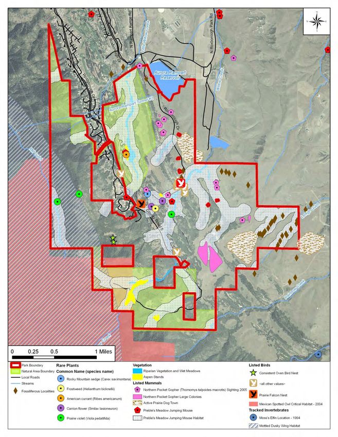
ACKNOWLEDGEMENTS

Development of the Roxborough State Park Management Plan was made possible through the
support and collaborative efforts of the Roxborough Management Planning Team (Planning Team),
Roxborough State Park Advisory Committee, State Parks Leadership Team, and interested members
of the public. Special thanks to other program, section, and park staff that provided input and
suggestions on draft iterations of the plan.
This management plan is the second to be developed using the Colorado State Parks Management
Plan Template, which was developed by a diverse committee comprised of experienced park and
program staff and was approved by the Parks Board in 2009.

               Roxborough State Park Management Planning Team
Scott Babcock, Strategic Planning Program Manager             Heather Dugan, High Plains Region Manager
Rob Billerbeck, Natural Resource & Stewardship Program        Shawn Krier, High Plains Region Development Manager
      Manager                                                 Eric Scholz, Capital Development Manager
Todd Farrow, Roxborough Park Manager                          Margaret Taylor, High Plains Region Assistant Manager

                      Roxborough State Park Advisory Committee
Sean Burke, One Roxborough                                    Trudy Peterson, Roxborough Park Foundation HOA
Del Kelley, Friends of Roxborough State Park                  Vickey Trammell, Roxborough State Park Volunteer

                          Colorado State Parks Leadership Team
                                                 Dean Winstanley, Director
Ken Brink, Assistant Director of Field Operations                 Gary Thorson, Assistant Director of Statewide Programs
Steve Cassin, Chief Financial Officer                             John Geerdes, Southeast Region Manager
Rich Dudley, Southeast Assistant Region Manager                   Kurt Mill, Rocky Mountain Region Manager
Heather Dugan, High Plains Region Manager                         Bob Wiig, Rocky Mountain Assistant Region Manager
Margaret Taylor, High Plains Assistant Region Manager             Eric Scholz, Capital Development Manager
Patrick Gavin, Chief of Public Safety                             Tom Morrissey, State Trails Program Manager

                                                Consultants
Special thanks to Computer Terrain Mapping, Inc. for their assistance in developing a digital
viewshed analysis from desired observation points within the Roxborough State Park and BBC
Research Inc for assisting with the Roxborough Financial Assessment.

                                                          i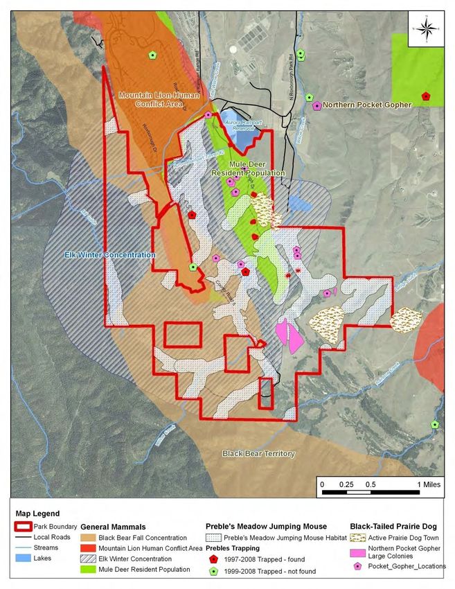
ii
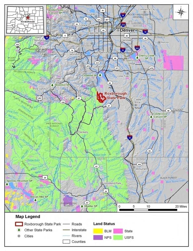
TABLE OF CONTENTS

1.0 Introduction .................................................................................................................................... 7
        Park Description .............................................................................................................................. 7
        Purpose of the Plan ......................................................................................................................... 7
        Park Goals ....................................................................................................................................... 8
        Future Plan Updates ....................................................................................................................... 9
        Previous Planning Efforts ................................................................................................................ 9
        Public Input Process ...................................................................................................................... 10
        Influences on Management .......................................................................................................... 12
        Management Considerations........................................................................................................ 12

2.0 Regional Planning Context ............................................................................................................ 15
        Physical Setting ............................................................................................................................. 15
        Climate .......................................................................................................................................... 15
        Eco-Regional Setting ..................................................................................................................... 16
        Adjacent Land Use and Land Ownership ...................................................................................... 17
        Local Recreation, and Tourism Trends, Needs, and Opportunities .............................................. 19
        Population Trends ......................................................................................................................... 20

3.0 Park Setting & Resources .............................................................................................................. 23
        Special Designations ..................................................................................................................... 23
        Park Land Ownership .................................................................................................................... 25
        Natural Resources ......................................................................................................................... 28
        Hydrology ...................................................................................................................................... 38
        Geology & Soils ............................................................................................................................. 39
        Cultural, Archaeological, and Paleontological Resources ............................................................. 40
        Scenic Resources ........................................................................................................................... 43
        Recreation Resources ................................................................................................................... 47
        Interpretation and Environmental Education ............................................................................... 49
        Facilities and Infrastructure .......................................................................................................... 50
        Operations & Maintenance .......................................................................................................... 52
        Visitation ....................................................................................................................................... 54
        Park Administration and Special Functions .................................................................................. 58
        Partnerships .................................................................................................................................. 60
        Economic Value............................................................................................................................. 65

4.0 Management Zoning ..................................................................................................................... 67
       Methodology for Determining Management Zones ..................................................................... 67
       Description of Management Zones............................................................................................... 67
       Area Descriptions that Influence Park Zoning............................................................................... 71

5.0 Park Enhancement Opportunities & Initiatives ............................................................................. 73
        Enhancement Opportunities......................................................................................................... 73

                                                                             iii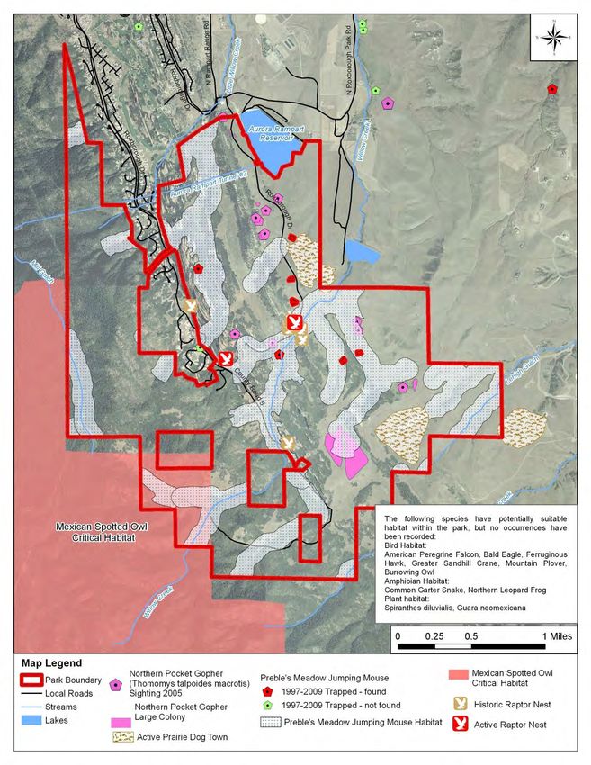
6.0 Implementation Priorities............................................................................................................. 79
Implementation Considerations ....................................................................................................79
Using the Implementation Plan .....................................................................................................79
7.0 Conclusion ..................................................................................................................................... 87
8.0 Appendices ................................................................................................................................... 89
Tables
Table 1 .Roxborough State Park Mean Temperatures ............................................................................. 15
Table 2. Roxborough State Park Average Precipitation Totals ................................................................. 16
Table 3. Local Recreation and Tourism Attractions .................................................................................. 20
Table 4. Trail Summary ............................................................................................................................. 47
Table 5. Importance of Park Features 2002-2009 ..................................................................................... 57
Table 6. Emergency Response Protocol .................................................................................................... 60
Table 7. Roxborough State Park’s Partnerships ....................................................................................... 60
Table 8. FY 08-09 Operating Expenditures ................................................................................................ 62
Table 9. FY 08-09 Utilities Expenditures ................................................................................................... 63
Table 10. FY 2009 Temporary Employee Expenditures ............................................................................. 63
Table 11. Management Zone Classification Scheme and Characteristics ................................................ 68
Table 12. Priority Management Actions at Roxborough State Park ......................................................... 81
Figures
Figure 1. Chatfield Basin Conservation Network Concept Plan (1998) ..................................................... 16
Figure 2. Type of Entrance Pass Used ....................................................................................................... 56
Figure 3. Annual Visitation Trends (2003-2009) ........................................................................................ 56
Figure 4. Budget Allocations (FY 2005-FY 2010) ....................................................................................... 64
Figure 5. Revenue by Fiscal Year. .............................................................................................................. 65
Figure 6. Revenue by Source .................................................................................................................... 65
Maps
Map 1. Location ........................................................................................................................................... 2
Map 2. Enhancement Opportunities ........................................................................................................... 5
Map 3. Regional Context Map ................................................................................................................... 18
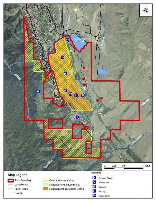
Map 4. Special Designations ...................................................................................................................... 24
Map 5. Land Ownership ............................................................................................................................. 26
Map 6. Significant Features ........................................................................................................................ 30
Map 7. Wildlife Habitat (Mammals) ........................................................................................................... 31
Map 8. Wildlife Habitat (Birds) .................................................................................................................. 32
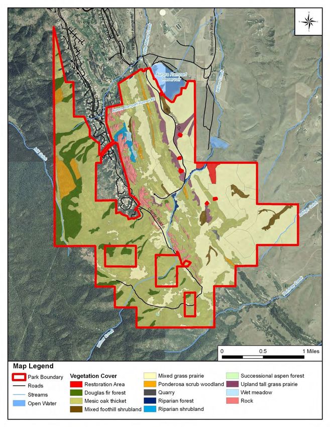
Map 9. Vegetation Cover............................................................................................................................ 34
Map 10. Threatened and Endangered Species........................................................................................... 37
Map 11. Cultural Resources....................................................................................................................... 42
Map 12. Viewshed Sensitivity from Trails and Roads................................................................................. 44
Map 13. Viewshed Sensitivity from Inside the Park Looking Out ............................................................. 45
Map 14. Viewshed Sensitivity from Lyons Overlook, Fountain Valley Overlook, and Visitor Center ........ 46
Map 15. Recreation and Facilities Infrastructure ...................................................................................... 51
Map 16. Engineering Suitability................................................................................................................. 69
Map 17. Management Zoning ................................................................................................................... 70
iv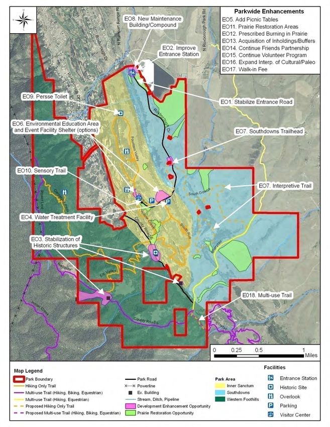
EXECUTIVE SUMMARY

                                Roxborough State Park is a popular 3,294-acre, day-use park located in Douglas County on the
                                edge of the foothills about 25 miles southwest of Denver. Roxborough is a geologically
                                significant site with more than 1.3 billion years of geologic time represented in elegant
                                sandstone spires and steep, colorful hogbacks. The park also features unique and high quality
                                plant communities, wildlife including large numbers of song birds and raptors, black bears,
                                mountain lions, mule deer and rare species such as Preble’s Meadow Jumping Mouse; as well
Roxborough offers a wide
variety of interpretation and
                                as abundant hiking and interpretive opportunities. Substantial portions of the park are
environmental education         designated as a Colorado Natural Area, National Natural Landmark, and National
opportunities for visitors.     Archaeological District. Roxborough State Park is known by many as one of the Colorado State
                                Park system’s “crown jewels” because of its remarkable landscape, beautiful natural features,
                                and abundant wildlife (all within close proximity to Denver).
                                Each year, close to 100,000 people visit Roxborough, but with continued population growth
                                projected along the Front Range, and a 3,100-acre master planned development (Sterling
                                Ranch) situated just a couple miles northeast of the park entrance, visitation and use of
                                Roxborough is projected to increase over time. 1 These factors, as well as the need to balance
                                use with protection of significant natural, geologic, and historic resources protected by the
                                park, influence many of the recommendations outlined in the Roxborough State Park
                                Management Plan.

                                About the Plan
                                Management Plans are an important planning tool for park managers. The Roxborough State
                                Park Management Plan serves as the foremost guiding document for Roxborough State Park.
                                All other park planning documents should be consistent with this plan.
                                The Roxborough State Park Management Plan provides a conceptual planning framework for
                                setting management priorities and provides specific management direction for park resources.
                                The plan also:
                                    •   Serves as a guide and policy document for current and future park staff, other
                                        partnering agencies, elected officials, and interested members of the public.
                                    •   Guides management of natural, cultural, and recreational resources.
                                    •   Provides a framework for monitoring and maintaining resources at Roxborough State
                                        Park.
                                    •   Identifies park enhancement opportunities including possible upgrades to or new park
                                        facilities, recreation infrastructure, etc.
                                    •   Serves as a guide for future park budget allocations and annual funding requests.
                                Included in the plan is a description of the complete spectrum of recreational, cultural, and
                                natural resources at Roxborough State Park. Implementation of the Roxborough State Park

                                1
                                Sterling Ranch website, 2009.

                                                                                1
Roxborough State Park Management Plan (2010-2020)

  Map 1. Location

                                                    2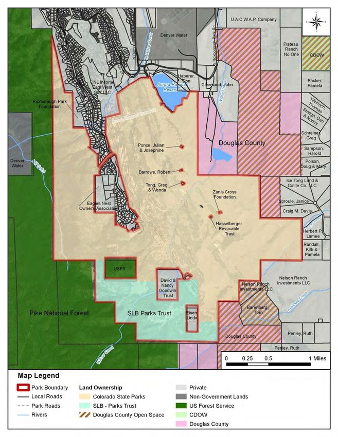
Executive Summary

Management Plan will assist park staff in their efforts to preserve and enhance the park for
future recreational users.
The Roxborough State Park manager should regularly review the park management plan to
evaluate implementation progress. This includes annually reviewing the document at the
beginning of each calendar year.

Park Goals
The following overarching goals set the tone for park management decisions at Roxborough
State Park. All management recommendations and priorities relate directly back to these
goals.
    a. Protect and interpret the significant natural, cultural, and paleontogical resources.
    b. Sustainably manage the park while planning ahead for anticipated increases in
       visitation associated with local and regional population growth.
    c. Offer a range of high quality visitor experiences that are compatible with park resource
       management needs.
    d. Provide high-quality customer service and opportunities to access and learn about
       park resources and enjoy popular recreation activities.
    e. Conduct development activities and operations in a manner that do not adversely
       affect park resources and environments.
    f. Build cost-effective, high quality recreation facilities that are aesthetically compatible,
       visually consistent with park resources, energy efficient, and which do not exceed the
       maintenance capabilities of park staff.
    g. Support retail opportunities that enhance the visitor experience.

Management Zoning
The management zoning scheme adapted specifically for Colorado State Parks provides a
framework for identifying areas that provide for different types of visitor experiences and
recreation opportunities, based on the resource constraints that occur within the park. Within
each management zone, suitable types of facilities and land uses are also identified, along with
the suggested visitor experience and management focus.
Influencing the zoning of Roxborough State Park were a number of factors including resource,
land ownership, and engineering suitability mapping (presented in subsequent sections of the
plan). In addition, historical activities, existing land uses, and other issues occurring in specific
areas of the park also influenced management zoning.
In addition to natural resource, land ownership, and engineering suitability mapping, other
factors influencing park zoning included historical activities, established land uses, and
acquisition history. At Roxborough State Park, three distinct areas were identified in the plan
(these are depicted on Map 2 and briefly discussed below). Additional details on these areas
and how they influenced Roxborough State Park’s management zoning are provided in Section
4.0.
Inner Sanctum — The Inner Sanctum area corresponds to much of the original “core” of
Roxborough State Park, which today includes the Visitor Center and hiking trails that extend
between the Dakota Hogback and the Fountain formations. This area experiences the highest
concentration of visitors and includes the most dramatic natural and scenic park features.

                                                  3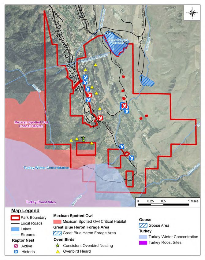
Roxborough State Park Management Plan (2010-2020)

Western Foothills — The Western Foothills occurs within the highest elevation area of the
park along a transitional vegetation zone that features upland mesic oak thicket and Douglas
fir forest. The highest peak in the park (Carpenter Peak) is located in this area, which offers
unparalleled views of the park below and much of the Front Range. Much of Roxborough’s
designated Colorado Natural Area Boundary is included in this area.
Southdowns Area — The Southdowns Area generally includes lands occurring along the
eastern one-third of the park, and is comprised of Roxborough State Park’s most recently
acquired lands (1997). Presently, little if any park visitation occurs in the Southdowns area.
The Sharptail Trail, which is a Douglas County trail that extends through Roxborough, is the
only trail currently situated in this portion of the park. Much of the Southdowns area features
mixed grass prairie with rolling hills topped with scrub oak thicket.

Summary of Recommended Park Enhancement Opportunities
Based on natural resource considerations, outdoor recreation trends, visitor preferences,
financial considerations, and other issues identified in this plan, there are a number of possible
park “enhancement opportunities” suggested for Roxborough State Park (Map 2). These
enhancement opportunities are discussed in detail in Section 5.0 Park Enhancement
Opportunities and Initiatives. All of the Enhancement Opportunities and other suggested
management priorities are included in the Summary Implementation Priorities Table included
in Section 6.0. Enhancement opportunities generally include park improvements that are
significant in terms of their spacial scale and level of effort needed to implement them, and
may warrant considerable financial resources. It is important to note that new facilities and
infrastructure should be balanced with maintaining and preserving what we already have.
Also, major new facility investments should be balanced with resource enhancements. Finally,
park enhancement opportunities are not “commitments.” Implementation of enhancement
opportunities and other recommendations in the management plan are contingent on the
park securing adequate financial and human resources. Any park enhancement that requires
additional funding or staffing must be considered or weighed within the context of other
Division-wide needs.

Existing Facilities and Infrastructure
        EO1.     Stabilization of Park Entrance Road
        EO2.     Improvements to Park Entrance Station
        EO3.     Stabilize and Interpret Historic Structures

New Facilities & Infrastructure
        EO4.     Water Treatment Facility
        EO5.     Add Picnic Tables
        EO6.     Environmental Education/Event Facility Shelter
        EO7.     Southdowns Trailhead and Interpretive Hiking Trails
        EO8.     New Maintenance Building/Compound

                                                    4
Executive Summary
Map 2. Enhancement Opportunities
5Roxborough State Park Management Plan (2010-2020)
EO9. Vault Toilet Adjacent to Persse Place
EO10. Sensory Trail near the Visitor Center
Rehabilitation & Restoration Efforts
EO11. Prairie/Grassland Restoration
EO12. Prescribed Burning for Ecological Restoration
Management Initiatives
EO13. Acquisition of Key Inholdings and/or Protection of Buffer Parcels
EO14. Continue to Build Partnership with the Friends of Roxborough State Park
EO15. Continue to Operate and Maintain a Successful Volunteer Program
EO16 Expand Interpretation of the Park’s Geological, Cultural & Paleontological
Resources
EO17. Establishment of Walk-In Fee
EO18. Formalize Multi-use Trail Connection to Nelson Ranch
Budget Considerations
During the development of the Roxborough State Park Management Plan, Colorado State
Parks experienced annual reductions in General Fund taxpayer support resulting in targeted
budget cuts in June 2009 and June 2010, as well as fee increases in FY 2010 and FY 2011. At
the time of formal adoption, Colorado State Parks projected that no General Fund Dollars
would be allocated to the Division in 2012.
These financial challenges were considered during the development of the Roxborough State
Park Management Plan, and helped influence the type and scale of suggested park
enhancements, as well as other implementation priorities. Despite current and ongoing
financial challenges, the Roxborough State Park Management Plan remains relevant and
should continue to be used as an important tool for planning the park’s future. While
Roxborough and many other parks are currently experiencing budget reductions, there will
indeed be a time when improving the park, and further investing in its natural and recreational
resources makes sense. Recommendations included in this plan will help guide such
investments.
Regardless of whether the Division secures funding for park enhancements, Roxborough is
fortunate to have the Friends of Roxborough, an extensive volunteer group, and other
stakeholders that have the capacity to generate significant financial resources. Additionally,
not all recommendations in the plan require a capital investment. Some of the recommended
park enhancements and management actions increase efficiencies, and do not require
additional capital or operating expenditures. Others may be paid for with the help of grants.
Such park enhancements should be pursued regardless of the present day financial situation.
61.0 INTRODUCTION
Park Description
Roxborough State Park is a popular 3,294-acre, day-use park Roxborough Vision
located in Douglas County on the edge of the foothills about Statement:
25 miles southwest of Denver. Roxborough is a geologically
Roxborough State Park
significant site with more than 1.3 billion years of geologic was established to
time represented in elegant sandstone spires and steep, protect unparalleled
colorful hogbacks. The park also features unique and high scenery and resource
quality plant communities, wildlife including large numbers values and does so
of song birds and raptors, black bears, mountain lions, mule through innovative
deer and rare species such as Preble’s Meadow Jumping outdoor recreation,
Mouse; as well as abundant hiking and interpretive educational and
opportunities. Substantial portions of the park are volunteer programs.
designated as a Colorado Natural Area, National Natural Roxborough will
continue to set a high
Landmark, and National Archaeological District. Roxborough
standard for
State Park is known by many as one of the Colorado State engagement with the
Park system’s “crown jewels” because of its remarkable natural environment
landscape, beautiful natural features, and abundant wildlife while preserving and
(all within close proximity to Denver). enhancing park
resources for future
Each year, close to 100,000 people visit Roxborough, but with
generations. The park
continued population growth projected along the Front will continue to serve
Range, and a 3,100-acre master planned development the people of Colorado
(Sterling Ranch 2) just a couple miles northeast of the park as a premier site for
entrance, visitation and use of Roxborough is projected to environmental
increase over time. This factor, as well as the need to education and resource
balance use with protection of significant natural, geologic, stewardship and is an
and historic resources protected by the park, help influence irreplaceable treasure
many of the recommendations outlined in the Roxborough within the Colorado
State Park Management Plan. State Park system.
Purpose of the Plan
The Roxborough State Park Management Plan serves as the
foremost guiding document for Roxborough State Park. The
ultimate purpose of developing the park management plan is
to outline the vision for the park (see inset) as well as
priorities that will provide for both the public’s enjoyment
and the protection of the park’s resources. The Plan provides
a conceptual planning framework for setting management priorities and provides specific
management direction for park resources. The Plan also:
2
Sterling Ranch website, 2009.
7Roxborough State Park Management Plan (2010-2020)
• Serves as a guide and policy document for current and future park staff, other
partnering agencies, elected officials, and interested members of the public.
• Guides management of natural, cultural, and recreational resources.
• Provides a framework for monitoring and maintaining resources at Roxborough State
Park.
• Identifies park enhancement opportunities including possible upgrades to or new park
facilities, recreation infrastructure, etc.
• Serves as a guide for future park budget allocations and annual funding requests.
Included in the plan is a description of the complete spectrum of recreational, cultural, and
natural resources at Roxborough State Park. Implementation of the Roxborough State Park
Management Plan will assist park staff in their efforts to preserve and enhance the park for
future recreational users.
The Roxborough State Park manager should regularly review the Plan to evaluate
implementation progress. This includes annually reviewing the document at the beginning of
each calendar year.
Relationship to the Division Strategic Plan
Using the Division Strategic Plan as an overarching guide, the Roxborough State Park
Management Plan serves as the primary “go-to” planning document for Roxborough State Park
staff. Specifically, the Division Strategic Plan is a useful guide for achieving a broad range of
Division-wide goals and objectives, while the management plan is the primary guidance
document for park-level planning efforts. The Roxborough State Park Management Plan is
consistent with the following Division-wide Mission, Vision, and Goals which are highlighted
below:
Mission
To be leaders in providing outdoor recreation through the stewardship of
Colorado’s natural resources for the enjoyment, education, and inspiration of
present and future generations.
Vision Statement
Colorado State Parks offer exceptional settings for renewal of the human spirit.
Residents and visitors enjoy healthy, fun-filled interaction with the natural world,
creating rich traditions with family and friends that promote stewardship of our
natural resources. Parks employees and their partners work together to provide
ongoing and outstanding customer service through recreational programs,
amenities, and services.
Division-wide Goals
• Goal 1: Connect People to the Outdoors by Providing Quality Outdoor Recreation
Opportunities and Settings
• Goal 2: Conserve, Enhance, Manage and Interpret Natural, Cultural, and Scenic
Resources
8Section 1.0- Introduction
• Goal 3: Foster and Actively Promote Excellence in our Workforce
• Goal 4: Stabilize and Strengthen Colorado State Parks’ Financial Condition
• Goal 5: Strengthen Outreach and Partnerships
Park Goals
• Protect and interpret the significant natural, cultural, and paleontogical resources.
• Sustainably manage the park while planning ahead for anticipated increases in visitation
associated with local and regional population growth.
• Offer a range of high quality visitor experiences that are compatible with park resource
management needs.
• Provide high-quality customer service and opportunities to access and learn about park
resources and enjoy popular recreation activities.
• Conduct development activities and operations in a manner that do not adversely affect
park resources and environments.
• Build cost-effective, high quality recreation facilities that are aesthetically compatible,
visually consistent with park resources, energy efficient, and which do not exceed the
maintenance capabilities of park staff.
• Support retail opportunities that enhance the visitor experience.
Future Plan Updates
The Roxborough State Park Management Plan should be updated every 10 years by park and
other Division staff (e.g., Division planning, region, natural resource, and capital development
staff). To ensure that the Plan is a dynamic document that meets the changing needs of the
park and visitors over time, the Plan may be supplemented with updated information as
needed, including minor changes to management actions, additional management actions that
help the park adapt to changes in recreational trends, and possibly additional mapping. This
may occur during the annual review at the beginning of the calendar year, or whenever relevant
information becomes available. In addition, at the 5-year mark, the Park Manager should
perform a detailed review of the plan and determine whether any formal amendments to the
Plan are necessary. In general, park management plans may need to be amended when changes
in circumstances are significant enough to merit changing the plan. Examples of when formal
amendments to the Plan may be necessary are listed below:
• Changes to the park land base (e.g., additional lands are purchased or portions of the
park are sold off)
• Major new facilities or infrastructure are planned for the park
• A policy or directive is instituted that significantly affects park management direction
• Major changes to land use occur within or adjacent to the park
• Changes to the Management Zoning are necessary
• Significant environmental stress (i.e., fire, drought, etc.)
Previous Planning Efforts
The following is a list of some of the relevant plans that were reviewed and considered in
developing this management plan:
• Roxborough State Park Natural Resource Stewardship Plan, Colorado State Parks, 2010
9Roxborough State Park Management Plan (2010-2020)
• Roxborough State Park Management Plan Update (Draft) – Colorado State Parks, 2002
• Roxborough State Park Management Plan – Colorado State Parks 1985 & 1987
• Roxborough State Parks Fuels Management Plan – November, 2005
• Interpretive Master Plan Roxborough State Park – Colorado State Parks, Undated
• Trail Impact Report for Roxborough State Park – PKM Design Group, Inc. 1999
• Concepts for Sustainable Trails – Sustainable Trails, Inc. January 2000
Public Input Process
Public input is an important part of the management planning process. Members of the public
were encouraged to provide input on the Plan at two public open house meetings conducted on
June 9, 2009 and May 11, 2010 at the West Metro Fire Station, District 15. The public was also
invited to submit comments online or via mail. Visitors to Roxborough were also encouraged to
complete surveys as part of the Corona Research Field Intercept Survey between June 2008 and
May 2009.
Public Open House Comments
The first open house meeting (June 9, 2009) was attended by about 20 interested community
members and provided them an opportunity to learn about the planning process. Attendees
also offered Parks staff valuable feedback on issues of interest or concern. A sampling of
comments gathered at the first meeting generally focused on a variety of subjects including:
• Addition of amenities such as a covered rest area and/or a covered environmental
education area
• Trail connections to Sharptail Trail in the South Downs area for mountain-biking and
equestrian use
• Parking area for mountain-bikers
• Improved interpretation of archaeological, paleontological, and geologic resources
• Sensory trail near the George O’Malley Visitor Center
• Preserving the main part of the park “as is”
At the May 11, 2010 open house meeting, Parks’ staff presented the public with ideas of
potential park enhancement opportunities being considered in the Draft Management Plan and
presented associated mapping; 33 community members attended and provided feedback. An
additional 15 written and email comments were submitted. A sampling of key takeaways and
comments gathered at the second meeting focused on a variety of subjects including:
• Stabilization of Historic Structures3 was assigned as being the highest priority
• Park enhancements EO9 (the multi-use trail) and EO7 (Environmental Education Area
and Event Facility Shelter (EE/EF shelter)) were identified as the lowest priorities
• Among the comments received, there was no clear consensus on the importance of park
enhancement EO8 (Southdowns trailhead and interpretive trail)
• Provide suitable parking options that accommodate trailers if equestrian use is allowed.
• Continue to encourage and work with Friends of Roxborough and other volunteers
• Preserve the natural resources of the park and protect it as a designated Natural Area
• Concern that multi-use trails may damage the park as a natural resource
10Section 1.0- Introduction
Online and Written Comments
Following the May 11, 2010 open house meeting, online comments were accepted until June 2,
2010 and an additional 15 written and email comments were received. Detailed comments
were received from a former park manager, several volunteer naturalists and Friends of
Roxborough, as well as from the Audubon Society of Greater Denver, and several equestrians.
Most of the detailed comments expressed strong concern regarding a multi-use trail and the
EE/EF shelter (EO7). Among comments provided were:
• Provide suitable parking options that accommodate trailers if equestrian use is allowed
• Concern over increased trash, disruption of wildlife and vegetation, vandalism, and that
multi-use trails will degrade the natural areas
• Concern that additional structures or parking lots will degrade existing viewsheds
• Continue to work with Friends of Roxborough and other volunteers; any new
interpretive programs should include their input
• Toilet at Persse Place would be welcomed
• Pave the entrance road
• Group and/or picnic table areas are not needed or wanted; a modest educational
shelter near the Visitor Center would be more preferable
• Concern about offering parking for overnight visitors accessing Pike National Forest
from Roxborough
Display boards and comment cards were also available in the park visitor center from May 17 to
May 30, 2010; park staff were trained how to answer questions and observed 56 people look at
the boards. Two additional comment cards were received during the display period. Those two
comments emphasized the importance of an environmental education facility and keeping the
park in as natural of a state as possible. The water treatment facility and environmental
education shelter were highest in priority and the multi-use trail and Southdowns Trailhead and
Interpretive Trail were lowest in priority.
Key Stakeholders
Key public and agency partners were involved in the development of the management plan in
order to ensure its success. Stakeholders listed in bold, below, participated as members of the
Roxborough State Park Advisory Council (RSPAC), which met quarterly throughout development
of the plan with members of the Roxborough Planning Team. Other key stakeholders
participated in public open houses and/or were contacted individually during development of
the plan to ensure they were informed of the planning process and that they could weigh in on
management plan recommendations if desired.
• Friends of Roxborough – Del Kelley, President
• One Roxborough – Sean Burke, Member
• Roxborough Park Foundation – Trudy Peterson, General Manager
• Vickey Trammel – Roxborough Volunteers
• Colorado Division of Wildlife – Matt Martinez, District Wildlife Manager
• Douglas County – Cheryl Matthews, Open Space Director
• Sterling Ranch LLC – Jack Hoagland, Principal
11Roxborough State Park Management Plan (2010-2020)
Visitor Survey
Visitor surveys were used as another tool to further gauge visitor ideas, needs, and issues.
Detailed results from the 2009 Corona Research Visitor Survey (discussed in Section 3.0 – Park
Setting and Resources) provided a rich dataset that enhanced the creation of this Plan.
Roxborough State Park staff and volunteers collected 328 completed surveys between June
2008 and May 2009, the second highest survey sample among the other State Parks.
Influences on Management
There are a number of outside or “external” factors that may influence park management (e.g.,
land development patterns and zoning adjacent to the park, population projections,
partnerships, etc.). Three of the more significant “external” forces that either indirectly or
directly influence park management that were factored into the Plan are listed below.
• Roxborough State Park is operated and managed as a day-use park. As such, plan
recommendations and overall management of the park is generally focused on
continued day-use operations.
• Continued population growth in and along the Front Range, and areas zoned for
residential and commercial development near the park, will inevitably increase visitor
use over time and may ultimately influence management needs.
• Public interest and support for Roxborough can be measured by the size of its Friends of
Roxborough group and the large number of volunteers that assist with park operations
and programs. The Friends of Roxborough is one of the strongest friends groups of any
park. There are over one hundred eighty (180) Roxborough volunteers that contribute
over 8,000 hours annually to the Volunteer Naturalists programs alone. These partners
to the Park are major stakeholders that provide tremendous support as well as influence
management direction.
Management Considerations
Management considerations include issues and concerns that have been identified by park staff
based on first-hand experience, knowledge, and/or information gathered from the public during
the open house meetings and through survey responses. Some of the specific key management
considerations addressed in this plan are as follows:
• Natural Resource Protection: As a designated Colorado Natural Area and National
Natural Landmark, continued protection of unique park features is central to future
management of Roxborough State Park.
• Diversification of Recreation Opportunities on Newly Acquired Lands: Roxborough
cannot be all things to all people; however, diversification of outdoor recreation
opportunities at the park may help generate added support for the park, ensure its long-
term operational success, and add additional recreational benefits for visitors.
• Long-term Operations and Maintenance: Long-term operations and maintenance
needs at Roxborough must be weighed alongside the inherent financial constraints of
Colorado State Parks.
12Section 1.0- Introduction
• Land Acquisition: There are numerous private inholdings within Roxborough. The
management plan evaluates the feasibility of uniting park inholdings and the need for
potential strategic land buffers.
• Visitor Center Renovation: With the George O’Malley Visitor Center recently renovated
in 2009, the park has an opportunity to explore new ways to enhance the visitor
experience.
• Office/Maintenance Needs: The original Visitor Center was designed in 1987 for one
full-time employee and has since increased to three full-time employees, limiting the
amount of space for storage and equipment. Currently Roxborough houses equipment
at the Visitor Center and at a garage at Chatfield State Park. Because of limited storage
space, the park does not have the maintenance equipment typical of a state park.
• Volunteer Program: The Friends of Roxborough, volunteer naturalists, and trail
stewards are important assets and allow visitors to give back to the park on a personal
level. Enhancing the Volunteer Program will provide vital services to the park and
maintain a healthy relationship with the public.
• Environmental Education: Roxborough offers premier and unique opportunities for
environmental education within the Denver Metropolitan Area. Environmental
education will continue to be a priority at this park.
13Roxborough State Park Management Plan (2010-2020)
142.0 REGIONAL PLANNING CONTEXT
Physical Setting
Roxborough State Park is located in the Denver Metropolitan Area along the Front Range. The
park is situated in the northwest corner of Douglas County and is flanked by Pike National
Forest to the west, and upland grassland communities to the east. The surrounding area is an
attractive mix of pine forests and rangeland. Residential development is scattered around the
park. Rural agricultural lands are also found to the east and southeast of the park.
Chatfield State Recreation Area is just three miles north of the park. Douglas County provides
multiple open space areas and trails for recreation within close vicinity of Roxborough, as well
as a number of local golf courses, including an award-winning 18-hole golf course that directly
borders the park (Arrowhead Golf Course). The closest incorporated towns are the Town of
Castle Rock (about 6.5 miles to the east) and Castle Pines North (about 7.5 miles to the
northeast). The City of Littleton and Columbine and Ken Caryl neighborhoods are located
approximately 13 miles north of the park.
The ridges of the Dakota, Lyons, and Fountain formations slice through segments of
Roxborough State Park. These ridges were formed when sedimentary beds were tilted to a 60-
80 degree angle by the upward mountain building activity of the Laramide Orogeny. Wind and
weather have sculpted them into present dramatic forms, creating a unique, scenic landscape.
Climate
Average daily temperatures at Roxborough State Park range from 30°F in December and
January to 73°F in July, and may fluctuate by as much as 31°F in a given month (Table 1).
Average annual precipitation totals 18.1 inches (Table 2). Roxborough is accustomed to typical
Front Range winters, receiving the majority of snow in March and April. Summer high
temperatures typically average the high 80’s. The many exposed rock formations within the
park absorb and retain heat. Southwest-facing rocky ledges always have the earliest spring
flowers because of the heat holding capacity of the rocks.
4
Table 1 .Roxborough State Park Mean Temperatures
Month Jan Feb Mar Apr May Jun Jul Aug Sep Oct Nov Dec Annual
Max °F 46.0 49.4 54.7 61.3 70.5 81.9 87.7 85.8 77.8 67.1 53.5 46.5 65.2
Mean °F 30.2 34.0 40.0 47.0 56.3 66.8 72.8 71.3 62.5 51.3 38.4 30.9 50.1
Min °F 14.3 18.5 25.2 32.6 42.1 51.7 57.8 56.8 47.1 35.5 23.3 15.3 35.0
Source: KASSLER Weather station, 0.91 miles from Roxborough Park
4
IDcide - Local Information Data Server. 20 Apr. 2009 .
15Roxborough State Park Management Plan (2010-2020)
Table 2. Roxborough State Park Average Precipitation Totals
Month Jan Feb Mar Apr May Jun Jul Aug Sep Oct Nov Dec Annual
Inch 0.57 0.58 1.68 2.36 2.85 1.69 1.60 1.80 1.52 1.28 1.33 0.80 18.06
Source: KASSLER Weather station, 0.91 miles from Roxborough Park
Much like other nearby areas along the Front Range, the park is often swept by northwest
winds. These winds are strongest in the spring and fall. Gusts of wind often precede summer
thunderstorms. Small spiraling “dust devils” accompany the winds, but tornadoes are not
common for this area. Lightning bolts have been known to jump from ridge to ridge during
thundershowers in a spectacular, but potentially dangerous display.
Eco-Regional Setting
Roxborough State Park is an integral component of the more broadly-defined Chatfield Basin,
which covers a large portion of western Douglas County and consists of a broad expanse of
public and private lands that drain into Plum Creek and the South Platte River (Figure 1).
Included within the Chatfield Basin is a species-rich transition zone (ecotone) that straddles
three ecological units, where the mountains meet the plains and northern and southern
communities merge. Hundreds of bird species inhabit this area. In total, nearly 400 species of
birds are known to nest or migrate through the Chatfield Basin. Rare animals in the Chatfield
Basin include the peregrine falcon, bald eagle, four species of minnows, the Federally-listed
Preble's meadow jumping mouse, and at least ten species of butterflies. 5
Figure 1. Chatfield Basin Conservation Network Concept Plan (1998)
5 Chatfield Basin Conservation Network. 14 June 2009 .
16Section 2.0 – Regional Planning Context
The Chatfield Basin study area includes the Plum Creek Watershed, which is generally bounded
on the south by the Palmer Divide; the east by I-25; the north by South Platte Park; and the
west by the Pike National Forest. Drainage is from south to north to the Chatfield Reservoir
and on to South Platte Park. This area contains important riparian corridors, recreation areas,
and scenic vistas. With more than 51,000 acres of protected open space and hundreds of
miles of trails, the Chatfield Basin is an important part of what makes western Douglas County
a special place.
Adjacent Land Use and Land Ownership
The entire western boundary of Roxborough State Park is adjacent to the Pike National Forest
(). According to the 1984 Land and Resource Management Plan for Pike and San Isabel
National Forests, these lands are managed primarily for Rural and Roaded-Natural Recreation
(Management Area 2B) and Wildlife Habitat for Management Indicator Species (Management
Area 4B). Management Area 2B supports a wide range of motorized and nonmotorized
recreation opportunities, and may be prohibited or restricted on designated routes to protect
physical and biological resources. Management Area 4B emphasizes protection of habitat for
one or more management indicator species. Recreation and other human activities are
regulated to favor the needs of designated species. 6 About 500 acres of forest within these
areas are scheduled for fuels treatment projects in the next few years. 7
Douglas County Open Space manages land just outside the North and Southwest corners of
the park, including Sharptail Ridge, Pike Hill, and Nelson Ranch Open Space areas. Most of
these lands experience passive recreational use such as hiking and horseback riding. In
addition, there is an adjacent protected property to the northwest (via a conservation
easement) that provides public access by “special arrangement” (Red Mesa Ranch) and
protected land to the southeast of the park with access prohibited (South Willow Creek). Just
to the northeast of the park is Rampart Reservoir, which is closed to the public and is owned
and managed by the City of Aurora. Two Denver Water properties are also located just north
of the Aurora Rampart Reservoir and within the Pike National Forest.
Roxborough Park subdivision, which is located along much of the park’s northern boundary, is
zoned Planned Development Urban (PDU) and consists of about 1,644 housing units. The
Indian Creek Ranch subdivision in Sedalia is a residential development with over 100 large-lot
ranchettes situated southeast of the park. Numerous other private residences within
unincorporated Douglas County also abut the park.
Eight private in-holdings and/or adjacent properties currently situated within Roxborough are
owned by:
• David and Nancy Goodwin Trust
• Preshaw-Eisen
• United States Forest Service
• Ponce (Lot #202)
6 U.S. Forest Service. U.S. Forest Service Land and Resource Management Plan for Pike and San Isabel Forests; Comanche and Cimarron National Grasslands.
1981. Print.
7 Personal communication with Matt Schweich, GIS Specialist for the South Platte Ranger District. 04 Feb. 2010. Print.
17Roxborough State Park Management Plan (2010-2020)
Map 3. Regional Context Map
18Section 2.0 – Regional Planning Context
• Barrows (Lot #161)
• Tong (Lot # 169)
• Zanis Cross Foundation (Lot #336)
• Hasselberger Revocable Trust (Joy Barber) 8
As of 2010, there were twelve privately-owned parcels exist directly adjacent to Roxborough
State Park, in addition to property owned by Douglas County and Douglas County Open Space,
the City of Aurora, and the U.S. Forest Service. Private property owners include:
• Davis
• Starbuck (Lot #3)
• Commercial Lot 2 (kiln site) owned by Roxborough Park Foundation
• Randall
• Nelson Ranch Investments, LLC
• Ice Tong Land & Cattle Co., LLC
• Lamee
• Roxborough Park Foundation
• Eagles Nest Owner’s Association
• Cleveland
• Haberer
• CNL Income Eagle West Golf LLC
Planned Development
In 2009, Sterling Ranch LLC submitted a Planned Development Application to Douglas County
for a 3,100-acre, mixed-use commercial and residential development project (current
estimates are around 10,000 households), situated about one mile from Roxborough State
Park. Although Sterling Ranch’s proponents stress that the proposed development will result
in a highly efficient, conservation-minded community located in an already growing county,
this development will likely directly affect the park (e.g. increased visitation and pressure to
access the park via alternate routes) as well as indirectly affect the park (e.g. wildlife
movement between Roxborough and Chatfield and increased light pollution/light glare).
Additional residential and commercial development (about 50 residential lots and 2 acres of
commercial development) is currently planned just north of the park adjacent to the proposed
park entrance.
Local Recreation, and Tourism Trends, Needs, and Opportunities
There is an abundance of outdoor recreation opportunities around Roxborough State Park
given its proximity to other state parks and county open space, neighboring national forests,
and abundant regional trails. The park attracts tourists from around the country and the
world. All of these opportunities must be considered when planning future park facilities.
Some of the more popular local attractions are presented below in Table 3.
Recreational use in northwest Douglas County and Roxborough State Park is likely to increase
over time in conjunction with projected population growth. In recent years, Roxborough staff
8
Parcel is pending purchase by Colorado State Parks as of January 13, 2010.
19Roxborough State Park Management Plan (2010-2020)
have fielded inquiries about expanding trail use to accommodate mountain bicyclists and
equestrians, providing overnight camping options, as well as group picnic areas.
Table 3. Local Recreation and Tourism Attractions
Approximate
Major Recreation Distance from Acres/Miles of
Attractions Roxborough trails Key Recreation Amenities
2,621 acres Wildlife viewing, hiking, horseback riding,
Castlewood Canyon SP 16 miles 15 miles picnicking, rock climbing
Camping, fishing, hiking, bicycling, boating,
5,318 acres jet-skiing, cross-country skiing,
Chatfield SP 3.5 miles 26 miles snowshoeing, horseback riding, swimming
Pike National Forest -
Waterton Canyon Area/South
Platte River < 1 mile Numerous Fishing, camping, cross-country skiing
Pike National Forest - Four-wheel driving, mountain biking,
Rampart Range Area 4 miles Numerous hunting, camping, fishing, rock climbing
8,000 acres (1,200
for recreational use)
Backcountry Wilderness Area 5-miles of multi-use
of Highlands Ranch 4 miles trails Wildlife viewing, hiking, walking, bicycling
2,000 acres
Highlands Ranch Metro 70 miles of multi-use
District 5 miles trails Wildlife viewing, hiking, walking, bicycling
Sharptail Ridge Open Space
(Sharptail Ridge Trail) < 1 mile 4.4 miles Hiking, horseback riding
Nelson Ranch Open Space
(Swallow Hill Trail) < 1 mile 3.3 miles Hiking, horseback riding, mountain biking
Park Hill < 1 mile 2.0 miles Hiking, horseback riding, mountain biking
Colorado Trail 1-2 miles 25 miles Hiking, mountain biking
Lamb Spring Archeological Mammal fossil remains, free monthly tours
Preserve 2.5 miles 35 acres available May through October
Population Trends
The population estimate for Douglas County as of January 1, 2009 is 290,311 persons, a 1.2%
increase from the previous year. Almost 90 percent of the population lives in urban
designated areas of the County. The incorporated cities and towns have 38.7% of the total
County population. The Town of Castle Rock and the Town of Parker are the two largest
incorporated places in the County, each with population estimates around 45,000 persons.
The City of Lone Tree and the City of Castle Pines North each have about 10,000 people. The
other major urban area in Douglas County is the Primary Urban Area (PUA) which includes
Highlands Ranch, Meridian International Business Center, and Stonegate. With a population of
approximately 119,000 people, it is 41% of the total County population. The combined
population of the three Separated Urban Areas (SUA), Roxborough, Castle Pines, and The
Pinery, is 25,000 people, or 8.7% of the County.
The last two years the County’s growth rate has slowed due to the downturn in the economy.
Still, Douglas County has typically experienced a higher growth rate than surrounding counties
and is projected to grow to 417,000 people by 2020. 9 The senior population, those people age
65 and over, was only 4.2% of the total County population in 1990 and 2000. According to the
American Community Survey 3-year estimate for 2005-2007, seniors made up 5.0% of the
9
Colorado County Population Projections (2000 - 2020). Raw data. Prepared by the Colorado Division of Local
Government, State Demography Office. Nov. 2008.
20You can also read