SECURING THE FRONTIER - BRYAN CLARK AND JESSE SLOMAN - CHALLENGES AND SOLUTIONS FOR U.S. POLAR MARITIME OPERATIONS - Center for Strategic and ...
←
→
Page content transcription
If your browser does not render page correctly, please read the page content below
SECURING THE FRONTIER
  CHALLENGES AND SOLUTIONS FOR
  U.S. POLAR MARITIME OPERATIONS

    BRYAN CLARK AND JESSE SLOMAN
SECURING THE FRONTIER
CHALLENGES AND SOLUTIONS FOR
U.S. POLAR MARITIME OPERATIONS

           BRYAN CLARK
           JESSE SLOMAN

               2017
ABOUT THE CENTER FOR STRATEGIC AND
BUDGETARY ASSESSMENTS (CSBA)
The Center for Strategic and Budgetary Assessments is an independent, nonpartisan policy
research institute established to promote innovative thinking and debate about national security
strategy and investment options. CSBA’s analysis focuses on key questions related to existing and
emerging threats to U.S. national security, and its goal is to enable policymakers to make informed
decisions on matters of strategy, security policy, and resource allocation.

©2017 Center for Strategic and Budgetary Assessments. All rights reserved.
ABOUT THE AUTHORS

Bryan Clark is a Senior Fellow at the Center for Strategic and Budgetary Assessments. Prior to
joining CSBA in 2013, Mr. Clark was special assistant to the Chief of Naval Operations and director
of his Commander’s Action Group, where he led development of Navy strategy and implemented
new initiatives in electromagnetic spectrum operations, undersea warfare, expeditionary
operations, and personnel and readiness management. Mr. Clark served in the Navy headquarters
staff from 2004 to 2011, leading studies in the Assessment Division and participating in the 2006
and 2010 Quadrennial Defense Reviews. His areas of emphasis were modeling and simulation,
strategic planning, and institutional reform and governance. Prior to retiring from the Navy in
2007, Mr. Clark was an enlisted and officer submariner, serving in afloat and ashore submarine
operational and training assignments, including tours as chief engineer and operations officer at
the Navy’s nuclear power training unit. Mr. Clark holds an M.S. in national security studies from the
National War College and a B.S. in chemistry and philosophy from the University of Idaho. He is the
recipient of the Department of the Navy Superior Service Medal and the Legion of Merit.

Jesse Sloman is an analyst at the Center for Strategic and Budgetary Assessments. Prior to joining
CSBA, Mr. Sloman worked for the Council on Foreign Relations. He served as an intelligence officer
in the Marine Corps from 2009 to 2013 and a civil affairs officer in the Marine Corps Reserve
from 2013 to 2016. He is the recipient of the 2012 Major General Michael E. Ennis Award for
Literary Excellence.
ACKNOWLEDGMENTS

The authors would like to thank the CSBA staff for their assistance with this report. Special thanks
go to Tom Mahnken for his guidance and editing, Kamilla Gunzinger for her production leader-
ship, and to and Adam Lemon for his excellent graphics. Thanks also go out to RADM Jeff Garrett,
USCG (Ret.) and RADM David Titley, USN (Ret.) for their detailed and insightful comments during
our review process. The analysis and findings presented here are solely the responsibility of the
authors. CSBA receives funding from a broad and diverse group of contributors, including private
foundations, government agencies, and corporations. A complete list of these organizations can be
found on our website at www.csbaonline.org/about/contributors.

Cover Graphic: The Coast Guard Cutter Healy breaks ice in the Nome harbor, January 13, 2012.
U.S. Coast Guard photo by Petty Officer 2nd Class Charly Hengen.
Contents
CHAPTER 1: INTRODUCTION.  .  .  .  .  .  .  .  .  .  .  .  .  .  .  .  .  .  .  .  .  .  .  .  .  .  .  .  .  .  .  .  .  .  .  .  .  .  .  .  .  .  .  .  .  .  .  .  .  .  .  .  .  .  .  .  . 1
        The Arctic and Antarctic Defined. . . . . . . . . . . . . . . . . . . . . . . . . . . . . . . . . . . . . . . . . . . . . 2
        A Changing Environment. . . . . . . . . . . . . . . . . . . . . . . . . . . . . . . . . . . . . . . . . . . . . . . . . . . 4
        Implications of Changing Polar Environments. . . . . . . . . . . . . . . . . . . . . . . . . . . . . . . . . . . . 5
CHAPTER 2: ARCTIC ISSUES.  .  .  .  .  .  .  .  .  .  .  .  .  .  .  .  .  .  .  .  .  .  .  .  .  .  .  .  .  .  .  .  .  .  .  .  .  .  .  .  .  .  .  .  .  .  .  .  .  .  .  .  .  .  .  .  . 7
        Territorial and Sovereignty Disputes . . . . . . . . . . . . . . . . . . . . . . . . . . . . . . . . . . . . . . . . . . 8
        Onshore and Offshore Oil and Gas Extraction. . . . . . . . . . . . . . . . . . . . . . . . . . . . . . . . . . . 12
        Onshore Mineral Resources. . . . . . . . . . . . . . . . . . . . . . . . . . . . . . . . . . . . . . . . . . . . . . . 15
        Arctic Shipping and Cruise Sailing. . . . . . . . . . . . . . . . . . . . . . . . . . . . . . . . . . . . . . . . . . . 15
        Fisheries. . . . . . . . . . . . . . . . . . . . . . . . . . . . . . . . . . . . . . . . . . . . . . . . . . . . . . . . . . . . . 21
        Military Competition. . . . . . . . . . . . . . . . . . . . . . . . . . . . . . . . . . . . . . . . . . . . . . . . . . . . . 22
        Summary . . . . . . . . . . . . . . . . . . . . . . . . . . . . . . . . . . . . . . . . . . . . . . . . . . . . . . . . . . . . 23
CHAPTER 3: ANTARCTIC ISSUES.  .  .  .  .  .  .  .  .  .  .  .  .  .  .  .  .  .  .  .  .  .  .  .  .  .  .  .  .  .  .  .  .  .  .  .  .  .  .  .  .  .  .  .  .  .  .  .  .  .  .  .  . 25
        Summary . . . . . . . . . . . . . . . . . . . . . . . . . . . . . . . . . . . . . . . . . . . . . . . . . . . . . . . . . . . . 29
CHAPTER 4: INTERNATIONAL POLAR PLANS .  .  .  .  .  .  .  .  .  .  .  .  .  .  .  .  .  .  .  .  .  .  .  .  .  .  .  .  .  .  .  .  .  .  .  .  .  .  .  .  .  .  . 31
        Russia . . . . . . . . . . . . . . . . . . . . . . . . . . . . . . . . . . . . . . . . . . . . . . . . . . . . . . . . . . . . . . 32
        Canada. . . . . . . . . . . . . . . . . . . . . . . . . . . . . . . . . . . . . . . . . . . . . . . . . . . . . . . . . . . . . . 34
        Norway. . . . . . . . . . . . . . . . . . . . . . . . . . . . . . . . . . . . . . . . . . . . . . . . . . . . . . . . . . . . . . 36
         Greenland (Denmark). . . . . . . . . . . . . . . . . . . . . . . . . . . . . . . . . . . . . . . . . . . . . . . . . . . . 36
         Finland. . . . . . . . . . . . . . . . . . . . . . . . . . . . . . . . . . . . . . . . . . . . . . . . . . . . . . . . . . . . . . 37
         Sweden . . . . . . . . . . . . . . . . . . . . . . . . . . . . . . . . . . . . . . . . . . . . . . . . . . . . . . . . . . . . . 38
         Iceland. . . . . . . . . . . . . . . . . . . . . . . . . . . . . . . . . . . . . . . . . . . . . . . . . . . . . . . . . . . . . . 38
         Australia. . . . . . . . . . . . . . . . . . . . . . . . . . . . . . . . . . . . . . . . . . . . . . . . . . . . . . . . . . . . . 38
         New Zealand. . . . . . . . . . . . . . . . . . . . . . . . . . . . . . . . . . . . . . . . . . . . . . . . . . . . . . . . . . 39
         China. . . . . . . . . . . . . . . . . . . . . . . . . . . . . . . . . . . . . . . . . . . . . . . . . . . . . . . . . . . . . . . 40
         Summary . . . . . . . . . . . . . . . . . . . . . . . . . . . . . . . . . . . . . . . . . . . . . . . . . . . . . . . . . . . . 41
CHAPTER 5: THE UNITED STATES’ POLAR STRATEGY AND CAPABILITIES. .  .  .  .  .  .  .  .  .  .  .  .  .  .  .  .  .  .  .  .  . 43
         Arctic Strategy and Policy. . . . . . . . . . . . . . . . . . . . . . . . . . . . . . . . . . . . . . . . . . . . . . . . . 43
         Antarctic Strategy and Policy. . . . . . . . . . . . . . . . . . . . . . . . . . . . . . . . . . . . . . . . . . . . . . . 45
         Security Considerations in the Polar Regions. . . . . . . . . . . . . . . . . . . . . . . . . . . . . . . . . . . 46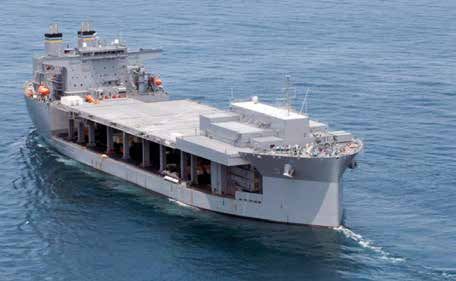
Military Activity in the Arctic During the Cold War . . . . . . . . . . . . . . . . . . . . . . . . . . . . . . . . 47
Post-Cold War Military Activity in the Arctic. . . . . . . . . . . . . . . . . . . . . . . . . . . . . . . . . . . . . 48
USCG Activity in the Arctic . . . . . . . . . . . . . . . . . . . . . . . . . . . . . . . . . . . . . . . . . . . . . . . . 49
Military Arctic Infrastructure and Force Posture . . . . . . . . . . . . . . . . . . . . . . . . . . . . . . . . . 50
USCG Arctic Infrastructure and Force Posture . . . . . . . . . . . . . . . . . . . . . . . . . . . . . . . . . . 51
Icebreaker Capacity. . . . . . . . . . . . . . . . . . . . . . . . . . . . . . . . . . . . . . . . . . . . . . . . . . . . . 52
Summary . . . . . . . . . . . . . . . . . . . . . . . . . . . . . . . . . . . . . . . . . . . . . . . . . . . . . . . . . . . . 54
CHAPTER 6: RECOMMENDATIONS AND CONCLUSION . . . . . . . . . . . . . . . . . . . . . . . . . . . . . . . . . . . . 55
New Roles and Missions . . . . . . . . . . . . . . . . . . . . . . . . . . . . . . . . . . . . . . . . . . . . . . . . . 55
Arctic and Antarctic Posture. . . . . . . . . . . . . . . . . . . . . . . . . . . . . . . . . . . . . . . . . . . . . . . 57
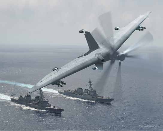
Polar Platforms and Systems. . . . . . . . . . . . . . . . . . . . . . . . . . . . . . . . . . . . . . . . . . . . . . 59
Conclusion . . . . . . . . . . . . . . . . . . . . . . . . . . . . . . . . . . . . . . . . . . . . . . . . . . . . . . . . . . . 64
LIST OF ACRONYMS . . . . . . . . . . . . . . . . . . . . . . . . . . . . . . . . . . . . . . . . . . . . . . . . . . . . . . . . . . . . . . 66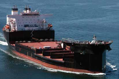
FIGURES
FIGURE 1: ARCTIC TERRITORIAL BOUNDARIES AND EXTENDED EEZ. . . . . . . . . . . . . . . . . . . . . . 10

FIGURE 2: CUMULATIVE ARCTIC OIL AND GAS PRODUCTION, 1960–2004 . . . . . . . . . . . . . . . . . 13

FIGURE 3: ARCTIC SHIPPING ROUTES . . . . . . . . . . . . . . . . . . . . . . . . . . . . . . . . . . . . . . . . . . . 16

FIGURE 4: ARCTIC SHIPPING ACTIVITY. . . . . . . . . . . . . . . . . . . . . . . . . . . . . . . . . . . . . . . . . . . 18

FIGURE 5: PROJECTED FUTURE ACTIVITY IN THE U.S. ARCTIC REGION. . . . . . . . . . . . . . . . . . . . 20

FIGURE 6: ANTARCTIC TERRITORIAL CLAIMS. . . . . . . . . . . . . . . . . . . . . . . . . . . . . . . . . . . . . . . 26

FIGURE 7: CHINESE FACILITIES IN EAST ANTARCTICA . . . . . . . . . . . . . . . . . . . . . . . . . . . . . . . . 27

FIGURE 8: ICE-CAPABLE ARMED NAVAL SHIPS . . . . . . . . . . . . . . . . . . . . . . . . . . . . . . . . . . . . . 32

FIGURE 9: ICEBREAKER INVENTORY AND CONSTRUCTION. . . . . . . . . . . . . . . . . . . . . . . . . . . . . 42

FIGURE 10: AN APPROXIMATION OF THE LOCATION OF THE DEW LINE . . . . . . . . . . . . . . . . . . . . 47

FIGURE 11: U.S. FORCE POSTURE IN THE HIGH LATITUDES. . . . . . . . . . . . . . . . . . . . . . . . . . . . 51

FIGURE 12: ILLUSTRATION OF THE DISTANCES BETWEEN NORTHERN ALASKA AND THE
NORTHERNMOST CGAS OR USCG DEEP DRAFT SEAPORT. . . . . . . . . . . . . . . . . . . . . . . . . . . . . 52

FIGURE 13: USCGC POLAR STAR. . . . . . . . . . . . . . . . . . . . . . . . . . . . . . . . . . . . . . . . . . . . . . . 53

FIGURE 14: USCGC HEALY . . . . . . . . . . . . . . . . . . . . . . . . . . . . . . . . . . . . . . . . . . . . . . . . . . . 53

FIGURE 15: EXPEDITIONARY SUPPORT BASE (ESB). . . . . . . . . . . . . . . . . . . . . . . . . . . . . . . . . . 58

FIGURE 16: EXPEDITIONARY SUPPORT DOCK (ESD) . . . . . . . . . . . . . . . . . . . . . . . . . . . . . . . . . 58

FIGURE 17: PROPOSED PATROL FRIGATE. . . . . . . . . . . . . . . . . . . . . . . . . . . . . . . . . . . . . . . . . 60

FIGURE 18: ITALIAN FREMM FRIGATE. . . . . . . . . . . . . . . . . . . . . . . . . . . . . . . . . . . . . . . . . . . . 61

FIGURE 19: TACTICALLY EXPLOITED RECONNAISSANCE NODE (TERN). . . . . . . . . . . . . . . . . . . . 63

FIGURE 20: MQ-8C FIRESCOUT. . . . . . . . . . . . . . . . . . . . . . . . . . . . . . . . . . . . . . . . . . . . . . . . 64
www.csbaonline.org   1

CHAPTER 1

Introduction
The Arctic and Antarctic regions are among the most challenging and remote environments on
earth. Ice, low temperatures, and moderate to high winds for much of the year make sustained
maritime operations difficult to conduct and support. When ships can get underway and
remain at sea, they need very long endurance to reach the next port or secure anchorage.

The polar regions are also very different from one another. The Arctic is mostly a maritime
region with longstanding shipping, fishing, and oil and gas exploration where temperatures
reach 50 degrees Fahrenheit in summer. Antarctica is a 1000-mile-wide continent surrounded
by the Southern Ocean where temperatures rarely rise above zero, and activity beyond scien-
tific research is largely precluded by treaty. Despite these differences, both regions remain
cold, remote, and sometimes choked by ice. The U.S. Coast Guard (USCG) and U.S. Navy
(USN) only have a small fleet of ships, aircraft, and unmanned vehicles that can operate in
these conditions to protect U.S. national security interests. Therefore, the maritime services
should consider the Arctic and Antarctic together when making decisions regarding polar
capabilities and force structure.

The tough weather and distance of polar regions from population centers and infrastructure
have limited most expeditions there to researchers or explorers using icebreakers and special-
ized aircraft, but that is changing. Both areas are becoming more accessible as warming oceans
shrink Arctic and Antarctic ice coverage and new technologies such as unmanned vehicles,
miniaturized electronics, and nano-engineered materials enable increased polar operations.

Improving access to the poles may facilitate increased exploitation of natural resources. Oil
and gas in the Arctic is mostly untapped, whereas resources in the Antarctic are protected by
treaty. Although the price of these commodities is relatively low today, establishing claims to
polar territory could offer nations future reserves to draw upon when prices rise as predicted
during the next decade. The polar regions also offer fisheries that have not been depleted and
new sources for minerals such as rare earth metals.
2   CSBA | SECURING THE FRONTIER

    Access to the Arctic and Southern Oceans can enable dramatic reductions in travel time
    between the Atlantic and Pacific Oceans. Trans-polar routes have been used by aircraft since
    the mid-twentieth century to move between Europe or Asia and North America. Shipping
    companies are beginning to use sea routes through the Arctic to save days to weeks on trans-
    oceanic transits, which can translate into hundreds of thousands of dollars of fuel and
    personnel costs.

    The Arctic and Antarctic regions are also militarily significant. Because polar routes are often
    the shortest between two nations, such as Russia and the United States, surveillance there is
    important to homeland defense and missions such as air and missile defense. The remoteness
    of polar coastlines makes them difficult and expensive to defend, which could be exploited to
    insert military forces or capabilities into enemy territory. A lesser-known military consider-
    ation for the poles is that, unlike satellites in geosynchronous Earth orbit (GEO), satellites in
    low or medium Earth orbit (LEO and MEO)—such as those in the Global Positioning System
    (GPS) constellation—rotate the earth several times a day. Without polar ground stations, these
    satellites would lose radio contact during part of their orbit.

    Growing interest in and access to the polar regions comes as the United States finds itself
    increasingly engaged in great power competition with China and Russia, which are attempting
    to revise the existing international order to their benefit.1 Both have invested heavily in their
    military capabilities in recent years, focused on contesting the regions adjacent to their
    borders and projecting power abroad. Their efforts extend to the poles; Moscow and Beijing
    are both pursuing natural resources, access to shipping routes, and the ability to influence
    Arctic and Antarctic governing bodies.2

    This study will describe America’s national security concerns in the Arctic and Antarctic and
    assess how they could be affected by changing polar conditions and increased regional activity.
    It will then explore new concepts and capabilities the United States could implement to better
    protect its interests and those of its allies and partners in Earth’s last frontier.

    The Arctic and Antarctic Defined
    The remoteness, small indigenous populations,3 and sparse land borders in the polar regions
    have driven reliance on international agreements to define territorial boundaries and provide

    1    Hal Brands and Eric S. Edelman, Why is the World So Unsettled? The End of the Post-Cold War Era and the Crisis of
         Global Order (Washington, DC: Center for Strategic and Budgetary Assessments, 2017), pp. 11–15.

    2    Department of Defense (DoD), Under Secretary of Defense (Policy), Report to Congress on Strategy to Protect United
         States National Security Interests in the Arctic Region (Washington, DC: DoD, December 2016), pp. 7–8, available at
         https://www.defense.gov/Portals/1/Documents/pubs/2016-Arctic-Strategy-UNCLAS-cleared-for-release.pdf; and Jane
         Perlez, “China, Pursuing Strategic Interests, Builds Presence in Antarctica,” New York Times, May 3, 2015, available at
         https://www.nytimes.com/2015/05/04/world/asia/china-pursuing-strategic-interests-builds-presence-in-antarctica.
         html?mcubz=0.

    3    About 4 million people live across the entire Arctic year-round. Only a few hundred researchers live in Antarctica over winter.
www.csbaonline.org 3
for Arctic and Antarctic governance. As defined in the 1984 Arctic Research and Policy Act,
Section 112, the Arctic consists of all regions above the Arctic Circle, or 66.6 degrees north lati-
tude, as well as seas and rivers contiguous with the Arctic.4 For example, the U.S. definition of
the Arctic includes the Bering Sea and the Aleutian Islands. The Antarctic region is defined by
the Antarctic Treaty and includes all land and sea areas south of 60 degrees south latitude.5
The United Nations Convention on the Law of the Sea (UNCLOS) provides rules for
establishing ownership of waters in and around the Arctic and Antarctic. Control of and
responsibility for polar areas ashore is established by existing national boundaries in the
Arctic and by treaty in the Antarctic.
The Arctic
Due to the Arctic’s geography and to agreements between adjoining countries, there are
no major territorial disputes in the region today. The Arctic is a largely maritime region
surrounded by the six nations with Arctic coastlines, limiting territorial disputes to the loca-
tion of maritime boundaries that extend 12 nm seaward from their land borders. With the
resolution in 2012 of the Norway-Russia maritime boundary, the remaining disputes involve
a small area of the Beaufort Sea adjacent to the Alaska-Yukon border and ownership of the
uninhabited Han Island between Canada and Greenland. Under UNCLOS, nations have
Exclusive Economic Zones (EEZ) extending 200 nm beyond the 12-nm territorial limit where
they can exert control over resource extraction. The Arctic Ocean is large enough that the
EEZs of the Arctic nations do not overlap. There is, however, the potential for disputes over
the expansion of EEZs to encompass the extended continental shelf of Arctic countries, partic-
ularly Greenland and Russia. These claims and potential disputes are detailed in Chapter 2.
Coordination of Arctic activities and governance is provided by the Arctic Council, an inter-
national group formed in 1996 by the eight countries with territory inside the Arctic Circle:
Canada, the Kingdom of Denmark (including Greenland and the Faroe Islands), Finland,
Iceland, Norway, Sweden, the Russian Federation, and the United States.6 Thirteen non-Arctic
states, including China, and several non-governmental organizations are observers to the
Arctic Council.
The Antarctic
The Antarctic Treaty of 1961 governs territorial claims and activities in the Antarctic region
and Antarctica. It recognizes preexisting territorial claims of seven nations that are adjacent
to the Antarctic or had longstanding activity there: Australia, New Zealand, Chile, Argentina,
4 Arctic Research and Policy Act, P.L. 98-373, July 31,1984 (amended as P.L. 101-609, November 16, 1990), available at:
https://www.nsf.gov/geo/opp/arctic/iarpc/arc_res_pol_act.jsp#104.
5 The Antarctic Treaty, Washington, DC, December 1, 1959, available at http://www.ats.aq/documents/ats/treaty_original.pdf.
6 Arctic Council, Declaration on the Establishment of the Arctic Council, Ottawa, Canada, 1996, available at https://
oaarchive.arctic-council.org/handle/11374/85.4 CSBA | SECURING THE FRONTIER
France, the United Kingdom, and Norway. The United States and Russia are recognized by the
Antarctic Treaty Secretariat as having a “basis for claim” they could exercise in the future. The
Antarctic Treaty does not allow any claimant to exert control over their claim or establish new
claims. This has precluded territorial disputes in the Antarctic.
The Antarctic Treaty is not permanent, however, and it could eventually change or be abro-
gated. This has led to efforts by countries such as China to establish a substantial permanent
presence in Antarctica that could be the basis for a future claim. And although the treaty
prohibits military operations, mining, and oil production in the Antarctic, it does allow scien-
tific research and potential “dual-use” activities such as communications and logistics, which
could support future military operations. These allowances have led to increasing efforts by
China, the United States, and to a lesser degree Russia to identify potential mineral and petro-
leum resources, install satellite communication and surveillance systems, and build airfields
and port facilities in Antarctica.
A Changing Environment
Temperatures in the Arctic and Antarctic are increasing consistently year over year, reducing
sea ice and changing weather patterns. In 2016, Arctic temperatures reached a record high,
and sea ice was the thinnest on record.7 Thin and uneven sea ice coverage, in turn, reduces the
amount of reflected solar energy, causing ocean temperatures to rise. This could contribute to
thinner ice the following year, continuing a cycle of warming oceans and melting ice. The U.S.
government predicts these trends will result in the Arctic being uncovered during the summer
by mid-century.8 This does not mean the Arctic will be completely ice-free. Even when the
Arctic Ocean is not covered by ice, ice floes and small icebergs will still be present, having
either calved off glaciers on the Arctic coastline or formed in colder areas of water created by
eddies or local weather.
The Antarctic is also experiencing warming and loss of sea ice. However, Antarctic tempera-
ture increases are not as large as those in the Arctic because the average altitude of Antarctica
is more than a mile. Antarctic ice coverage is highly variable, but, on average, ice cover in
Antarctica today is 18.2 percent below the 1981–2010 average.9
7 National Snow and Ice Data Center, “Arctic Sea Ice Extent,” Arctic Sea Ice News & Analysis, Daily Image Update,
September 5, 2017, available at https://nsidc.org/arcticseaicenews/; and Chris Mooney and James Samenow, “The North
Pole is an Insane 36 Degrees Warmer Than Normal as Winter Descends,” Washington Post, November 17, 2016, available
at https://www.washingtonpost.com/news/energy-environment/wp/2016/11/17/the-north-pole-is-an-insane-36-
degrees-warmer-than-normal-as-winter-descends/?utm_term=.ce032a816b40.
8 See Jerry Melillo, Terese Richmond, and Gary Yohe, eds., Climate Change Impacts in the United States: The Third
National Climate Assessment (Washington, DC: U.S. Global Change Research Program, 2014), Figure 2.29, “Projected
Arctic Sea Ice Decline,” available at http://nca2014.globalchange.gov/report/our-changing-climate/melting-ice/graphics/
projected-arctic-sea-ice-decline.
9 Scott Waldman, “Climate Change Is Turning Antarctica Green,” Scientific American, May 19, 2017, available at https://
www.scientificamerican.com/article/climate-change-is-turning-antarctica-green/.www.csbaonline.org 5
In addition to reducing sea ice, higher temperatures melt permafrost. This is especially prob-
lematic in Arctic Alaska and Siberia where coastal roads, port infrastructure, and airfields are
built upon low-lying permafrost. Today, towns in Alaska are relocating; the land is melting
underneath them and rising sea levels cause more frequent flooding.10 The loss of associated
ports and airfields could make Arctic logistics and search and rescue (SAR) more difficult.
The melting of permafrost also contributes to future climate change. Permafrost binds carbon
in the cellulose of its mosses and lichens. When it melts and the plant materials decompose,
this carbon is released as carbon dioxide and methane, increasing greenhouse gas concentra-
tions in the atmosphere.11
Implications of Changing Polar Environments
Receding polar ice will make the Arctic and the Antarctic regions more accessible for longer
periods each year. Natural resources such as oil, gas, and fisheries will become easier to find
and exploit, which could increase demands on naval and coast guard forces for regulatory
enforcement, maritime security, SAR, and environmental response. Warming waters and
thinner ice will also enable military operations and shipping to expand in the polar regions.
Although the Antarctic Treaty precludes military operations in the region, non-combat activi-
ties such as logistics, surveillance, and communications are generally interpreted to lie outside
its scope.
The current U.S. fleet of ships and aircraft capable of operating in the Arctic and Antarctic is
aging and shrinking. The USCG has two heavy icebreakers, one of which is operable, and one
medium icebreaker; the National Science Foundation operates a light icebreaker.12 Although
submarines can operate under polar ice and surface through pack ice, the USN has no ice-
hardened surface combatants, amphibious ships, or aircraft carriers (CVN) able to operate
in regions containing icebergs or ice floes. The U.S. Air Force has ten LC-130 aircraft able to
operate from polar bases such as those in Antarctica.13 Together, these forces will not have
sufficient capacity or the right capabilities to address growing demands for polar operations
such as maritime security, SAR, surveillance, or disaster response.
10 Robert Ferris, “Thawing Alaska Permafrost Alarms Scientists,” CNBC, August 23, 2017, available at https://www.cnbc.
com/2017/08/23/thawing-alaska-permafrost-alarms-scientists.html.
11 Henry Fountain, “Alaska’s Permafrost Is Thawing,” The New York Times, August 23, 2017, available at https://www.
nytimes.com/interactive/2017/08/23/climate/alaska-permafrost-thawing.html?mcubz=0&_r=0.
12 The Coast Guard classifies a heavy icebreaker as one having more than more than 45,000 brake horsepower (BHP)
propulsion power; a medium icebreaker as having 20,000 to 45,000 BHP; and a light icebreaker as having less than 20,000
BHP. See U.S. Coast Guard, “U.S. Coast Guard’s 2013 Review of Major Icebreakers of the World,” USNI News, July 23,
2013, available at https://news.usni.org/2013/07/23/u-s-coast-guards-2013-reivew-of-major-ice-breakers-of-the-world.
13 Kerry Jackson, “LC-130 takes off for Operation Deep Freeze,” U.S. Air Force News, October 21, 2010, available at http://
www.af.mil/News/Article-Display/Article/115244/lc-130-takes-off-for-operation-deep-freeze/.6 CSBA | SECURING THE FRONTIER
This report assesses likely requirements for USN and USCG operations that will result from
the changing nature of Arctic and Antarctic activities. This will include protection and support
of commercial ventures such as shipping, tourism, and resource exploitation as well as mili-
tary operations to protect U.S. and allied territory and EEZs. The report will translate these
future needs into recommendations for new operational concepts and capabilities that will
improve the ability of USN and USCG forces to protect U.S. interests in these last frontiers.www.csbaonline.org 7
CHAPTER 2
Arctic Issues
America’s national security interests in the Arctic include sustaining maritime access,
protecting natural resources, and preventing hostile powers from encroaching on the terri-
tory of the United States and its allies and partners. As ice coverage recedes, shipping lanes
and resources such as oil, gas, minerals, and fisheries will become more accessible. The Arctic
nations and China are increasing the number and frequency of commercial and military oper-
ations in the polar regions to begin exploiting these potential benefits. This may also establish
a pattern of use to support future territorial claims.
The Arctic Council is “the leading intergovernmental forum promoting cooperation, coordi-
nation, and interaction among the Arctic states.” It is composed of the eight Arctic states,13
non-Arctic observer states, and six organizations representing indigenous Arctic natives.14
While it is not an enforcement body and does not deal with security issues, the Arctic Council
does provide a consultative function between nations having territory above the Arctic Circle.
Finland, Sweden, and Iceland are all Arctic Council members who do not have any coastline
on the Arctic Ocean. They are sometimes referred to as the “Arctic Three” to contrast them
with the “Arctic Five” countries that have Arctic coasts.15
14 “The Arctic Council: A Backgrounder,” Arctic Council, May 26, 2017, available at https://www.arctic-council.org/index.
php/en/about-us.
15 Willy Ostreng et al., Shipping in Arctic Waters (Heidelberg, Germany: Springer-Verlag Berlin, 2013), p. 67.8 CSBA | SECURING THE FRONTIER
Territorial and Sovereignty Disputes
There are no major disputes over territorial waters or EEZs in the Arctic; there are, however,
four less-significant unresolved Arctic territorial and sovereignty issues that are being
addressed through mid-level diplomatic negotiations:
1. Canada and the United States disagree over the maritime boundary between their EEZs
in the Beaufort Sea. In 2016, the United States proposed including the disputed area
in its 2017–2022 offshore oil and gas leasing program. In response, Canada alleged
that the sale would violate its sovereignty.16 Both the Chukchi and Beaufort Sea areas
were subsequently removed from the 2017–2022 lease program when the Obama
Administration placed large portions of the U.S. Arctic off-limits to oil and gas drilling.17
Current efforts by the U.S. government to restart Arctic oil and gas leasing may resurface
this disagreement.
2. The United States maintains that the Northwest Passage and Northern Sea Route Arctic
shipping routes should be treated as international straits outside the control of any single
country. Canada and Russia maintain that these passages are inland waterways that can
be regulated and controlled by the claimant countries.18
3. The United States and Russia have a dispute over one area of the Bering Sea. An agree-
ment was signed in 1990 to allow the United States to exercise EEZ jurisdiction over
the area, and that agreement has been adhered to in subsequent diplomatic exchanges.
Although the agreement was ratified by the U.S. Senate, it has yet to be confirmed by the
Russian Duma.19
4. Denmark and Canada have an ongoing disagreement concerning the status of Hans
Island, an uninhabited island in the strait between Nunavut and Greenland.20
16 Chris Windeyer, “Proposed U.S. Beaufort Sea Drilling Leases Infringe on Canada’s Sovereignty, Says Yukon,” CBC News,
March 19, 2016.
17 Darryl Fears and Juliet Eilperin, “President Obama Bans Oil Drilling in Large Areas of Atlantic and Arctic Oceans,”
Washington Post, December 20, 2016.
18 Ostreng et al., Shipping in Arctic Waters, p. 13.
19 Ronald O’Rourke, Changes in the Arctic: Background and Issues for Congress (Washington, DC: Congressional Research
Service, December 7, 2016), p. 22.
20 Ibid., p. 22.www.csbaonline.org 9
A more significant series of disputes may emerge over the next decade regarding extended
continental shelves. Article 76 of UNCLOS grants countries rights over natural resources in
the seabed of their continental shelves that go beyond the boundaries of their 200 nm EEZ
to a maximum of 350 nm from their coasts.21 Canada, Russia, Norway, and Denmark have
submitted, have plans to submit, or intend to carry out revisions to their extended continental
shelf (ECS) claims in the Arctic. Many of these ECS claims could overlap one another. And
although it is not a signatory to UNCLOS, the United States has established an interagency
task force, the U.S. ECS Project, charged with “coordinating the collection and analysis of all
relevant data and preparing the necessary documentation to establish the outer limits of the
U.S. ECS.”22
Figure 1 depicts territory claimed in the Arctic, including EEZs and potential extensions of
EEZs. It is likely that ECS claims from Denmark, Russia,23 the United States, and Canada24
could overlap one another. This is especially problematic regarding Russia, given the impor-
tance of the Arctic to Russian national security. The Arctic is the source for most Russian
natural gas and some oil. More importantly, the Arctic Ocean is a key operating location for
Russia’s ballistic missile submarines (SSBN) and it provides a protected bastion within the
Barents, Kara, and White Seas in which the Russian Northern Fleet can train and transit to
open ocean.
21 United Nations Convention on the Law of the Sea, December 10, 1982, art. 76, “Definition of the Continental Shelf,”
available at http://www.un.org/depts/los/convention_agreements/texts/unclos/unclos_e.pdf.
22 “What is the U.S. ECS Project?” U.S. Extended Continental Shelf Project, accessed on August 22, 2017, available at
https://www.continentalshelf.gov/about/index.htm.
23 Bob Reiss, “Why Putin’s Russia Is Beating the U.S. in the Race to Control the Arctic,” Newsweek, February 25, 2017,
available at http://www.newsweek.com/why-russia-beating-us-race-control-arctic-560670.
24 Levon Sevunts, “Canada to Submit Its Arctic Continental Shelf Claim in 2018,” Radio Canada International, May 3, 2016,
available at http://www.rcinet.ca/en/2016/05/03/canada-to-submit-its-arctic-continental-shelf-claim-in-2018/.10 CSBA | SECURING THE FRONTIER
Maritime jurisdiction and boundaries in the Arctic region
FIGURE 1: ARCTIC TERRITORIAL BOUNDARIES AND EXTENDED EEZ
180° E / W
3’N)
6°3
e (6
ircl C
US tic
Arc
A
W
13
5°
5°
13
E
A
I
C
S
A
e
S
g
d
N
i
R
U
v
A
o
s
o
R
n
D
o
North
m
90°W 90°E
Pole
o
A
L
re
G
D en
(
E
N
M
la
A nd
R
K
)
°E
45
45
°W
RUS S I A
NORWAY
F I NL AND
ICE S WE DE N Polar stereographic projection
LAN
D
0 nautical miles 400 at 66°N
0°E / W
0 kilometres 600
Map Source:
Internal IBRU, Durham University, UK. The original map is available at http://www.durham.ac.uk/ibru/resources/arctic, along
waters withbaselines
Straight the briefing
Russia territorial sea and EEZ
notes that accompany the map.
Canada territorial sea and Russia claimed continental shelf
Agreed boundary
exclusive economic zone (EEZ) beyond 200 M (note 4)
Potential Canada continental shelf
Norway-Russia Special Area (note 5) Median line
beyond 200 M (see note 1)
Denmark territorial USA territorial sea and EEZ 350 M from baselines (note 1)
sea and EEZ
Denmark claimed continental shelf Potential USA continental shelf 100 M from 2500 m isobath
beyond 200 M (note 2) beyond 200 M (note 1) (beyond 350 M from baselines) (note 1)
Iceland territorial sea and EEZ Overlapping Canada / USA EEZ (note 6) Svalbard treaty area (note 8)45 °E
°W 45
R USSIA
N O RWAY
FINLAND
ICE S WED EN Polar stereographic projection
LAN
D
0 nautical miles 400 at 66°N
0°E / W
0 kilometres 600
Internal waters Russia territorial sea and EEZ Straight baselines
Canada territorial sea and Russia claimed continental shelf
Agreed boundary
exclusive economic zone (EEZ) beyond 200 M (note 4)
Potential Canada continental shelf
Norway-Russia Special Area (note 5) Median line
beyond 200 M (see note 1)
Denmark territorial USA territorial sea and EEZ 350 M from baselines (note 1)
sea and EEZ
Denmark claimed continental shelf Potential USA continental shelf 100 M from 2500 m isobath
beyond 200 M (note 2) beyond 200 M (note 1) (beyond 350 M from baselines) (note 1)
Iceland territorial sea and EEZ Overlapping Canada / USA EEZ (note 6) Svalbard treaty area (note 8)
Iceland claimed continental shelf
Russia-USA Eastern Special Area (note 7) Iceland-Norway joint zone (note 9)
beyond 200 M (note 2)
Norway territorial sea and EEZ / Fishery zone (Jan Unclaimed or unclaimable continental Main 'Northwest Passage' shipping routes
Mayen) / Fishery protection zone (Svalbard) shelf (note 1) through Canada claimed internal waters
Norway claimed continental shelf
beyond 200 M (note 3)
U: Centre for Borders Research www.durham.ac.uk
www.csbaonline.org
1112 CSBA | SECURING THE FRONTIER
Onshore and Offshore Oil and Gas Extraction
The resolution of competing Arctic ECS claims would have limited economic implications. In
2008, the U.S. Geological Survey (USGS) estimated that 13 percent of the world’s undiscov-
ered oil and 30 percent of the world’s undiscovered gas lay in the Arctic.25 The USGS assesses
that most of these reserves are within the 200 nm EEZ limit and are concentrated between
the shoreline and the 500-meter contour line.26 While some oil and gas is projected to be in
potentially disputed extended EEZs, this oil would be some of the most expensive Arctic oil
to extract.
Confrontations over offshore Arctic oil reserves, if they occur, are not likely until the 2020s at
the earliest. Drilling in the Arctic is technically challenging and expensive. Low temperatures
can cause equipment to fail if it is not specially designed to cope with the climate. The high
latitude region offers little infrastructure to support drilling and extraction, forcing companies
to build their own or invest in costly work-arounds. Offshore drilling can only occur during
summer months and, even then, only with the assistance of ice-hardened ships or icebreakers.
Extraction costs for offshore Arctic oil average about $70 per barrel.27 Oil prices have been
between $48 and $58 per barrel during 2017 and are not projected to reach $70 per barrel
until 2020, when current excess stockpiles are depleted.28 The Russian government, which
has aggressively asserted its territorial claims elsewhere, estimates its cost to extract offshore
in its portion of the Arctic are between $70 and $100 per barrel. This has constrained
Russia’s offshore production and could reduce the likelihood of confrontations over disputed
extended EEZs.29
That is not to say oil and gas production are not economically viable ashore or in more acces-
sible areas of the Arctic. The first Arctic oil and gas discoveries occurred in the 1920s and
1930s in Canada, Alaska, and northern Russia.30 Sixty-one large hydrocarbon fields have been
identified in the Arctic since then, 46 of which are in production. Of those 61 large fields, 42
are in Russia, six in Alaska, 11 in Canada, and one in Norway.31
25 Donald L. Gautier et al., “Assessment of Undiscovered Oil and Gas in the Arctic,” Science 324, no. 5931, May 29, 2009.
26 Ostreng et al., Shipping in Arctic Waters, p. 102.
27 James Henderson, “How Saudi Arabia’s Grip on Oil Prices Could Bring Russia to Its Knees,” War in Context, February 2, 2016,
available at http://warincontext.org/2016/02/02/how-saudi-arabias-grip-on-oil-prices-could-bring-russia-to-its-knees/.
28 “End of day Commodity Futures Price Quotes for Crude Oil WTI (NYMEX),” NASDAQ, August 23, 2017, available at
http://www.nasdaq.com/markets/crude-oil.aspx?timeframe=1y; and International Energy Agency, “Global Oil Supply
to Lag Demand after 2020 Unless New Investments are Approved Soon,” IEA Newsroom, March 6, 2017, available
at https://www.iea.org/newsroom/news/2017/march/global-oil-supply-to-lag-demand-after-2020-unless-new-
investments-are-approved-so.html.
29 Elena Mazneva and Dina Khrennikova, “Russia Can Wait for $70 Oil Before Re-Entering Arctic Waters,”
Bloomberg, updated March 29, 2017, available at https://www.bloomberg.com/news/articles/2017-03-28/
russia-can-wait-for-70-oil-before-returning-to-arctic-waters.
30 Arctic Monitoring and Assessment Program (AMAP), Arctic Oil and Gas 2007 (Oslo, Norway: AMAP, 2007), p. 14.
31 Ostreng et al., Shipping in Arctic Waters, p. 99.www.csbaonline.org 13
Cumulative
FIGURE 2: CUMULATIVE Arctic
ARCTIC OILOil
ANDand Gas
GAS Production
PRODUCTION, (1960–2004)
1960–2004
12000
10000
8000
6000
4000
2000
0
Russia United States Canada Norway
Oil (millions m3) Gas (billions m3)
Data from Arctic Oil and Gas 2007, pp. 16–17.
Of all the states currently undertaking Arctic oil and gas extraction, Russia has the most
mature high latitude production apparatus and is responsible for roughly 80 percent of all
Arctic oil and 99 percent of all Arctic gas production. Within Russia, Arctic fields supplied 81
percent of natural gas output and 17 percent of crude output in 2016, making the region crit-
ical to Russia’s economic wellbeing.32 Existing Russian Arctic hydrocarbon fields are mostly
located in Western Siberia, and their output is expected to fall abruptly over the next two
decades.33 Russia hopes to offset this decline by developing new offshore fields in the Barents
and Kara Seas. However, Russia has so far avoided expanding its exploration of the offshore
Arctic fields while oil remains below $70 a barrel.34
Most Norwegian oil production has come from large fields in the North Sea. Norway’s oil
output reached its peak in 2001 and has declined ever since. Consequently, exploration in the
comparatively under-examined Barents Sea is critical to the country’s future as a major oil
exporter.35 In contrast to Russia, Norway is drilling new wells in the Barents Sea because its oil
companies are confident they can break even despite low oil prices. One factor contributing to
Norway’s bullishness is the lack of sea ice in the portion of the Barents just north of Norway,
which reduces the costs of extraction operations relative to other Arctic locations.36
Like Russia and Norway, Alaska faces declining oil production from its existing onshore
fields. An additional variable for Alaska is the minimum level of throughput required to keep
32 Mazneva and Khrennikova, “Russia Can Wait for $70 Oil.”
33 Barry Scott Zellen, ed., The Fast-Changing Arctic: Rethinking Arctic Security for a Warmer World [Kindle version]
(Calgary, Alberta: University of Calgary Press, 2013), loc. 5816.
34 Mazneva and Khrennikova, “Russia Can Wait for $70 Oil.”
35 Mikael Hook and Kjell Aleklett, “A Decline Rate Study of Norwegian Oil Production,” Energy Policy 36, no. 11,
November 2008.
36 Mikael Holter, “What Oil Crisis? Arctic Drilling Off Norway Set for Record,” Bloomberg, February 15, 2017.14 CSBA | SECURING THE FRONTIER
the Trans-Alaska Pipeline System (TAPS) economically viable. TAPS was completed in 1977
and runs between Prudhoe Bay and Valdez, Alaska, after which oil is transferred to tankers
for shipment to the lower 48 states. The pipeline is crucial to the success of North Shore oil
production in Alaska because it obviates the need to send tankers around the Aleutian Islands
into the challenging North Alaskan seas. TAPS has also allowed Alaska to develop North Shore
energy projects without a nearby deep draft port.
Without significant new sources of northern Alaska oil, the rate of production decline at
existing North Shore oil fields could make oil too expensive to ship via TAPS by the mid-
2020s.37 The pipeline may continue to operate at low throughput levels thanks to its
importance for the Northern Alaskan region, but the increasingly high costs of operation will
dissuade oil companies from investing in new North Shore oil projects.
The late 2000s were a period of great optimism for oil development along the Alaskan North
Shore. However, the declining oil prices of the past few years and the technical challenges
of operating in the Arctic have reduced oil companies’ appetite for Alaskan oil develop-
ment. In 2015, Shell elected to discontinue exploration following a collection of disappointing
results from a test well in the Chukchi Sea after spending seven years and $8 billion. In 2016,
Royal Dutch Shell, ConocoPhillips, and others gave up drilling rights in Alaska that had been
purchased for a total of $2.5 billion.38 In June 2017, the U.S. oil company Caelus declared that
it would delay drilling a test well at its discovery in Alaska’s Smith Bay due to low oil prices,
challenging local conditions, and a tax dispute with the Alaskan government.39
Despite these setbacks, the U.S. government continues to promote oil exploration in Alaska by
seeking a reversal of the current ban on oil exploration in the Arctic National Wildlife Refuge
(ANWR).40 New onshore discoveries may allow oil companies to avoid the costly technical
complications of offshore drilling in the Arctic. In March of 2017, a partnership between the
Spanish oil company Repsol and the U.S. company Armstrong Oil and Gas announced that it
had discovered a 1.2 billion-barrel onshore field adjacent to the National Petroleum Reserve-
Alaska (NPR-A) that could be ready for production by 2021.41 If those projections are accurate,
then the Repsol-Armstrong field would be the largest onshore discovery in Alaska of the past
three decades. A second large field was discovered by ConocoPhillips in the NPR-A in March
2017 that could yield as much as 100,000 barrels of oil daily.42
37 Tim Bradner, “Infrastructure Investment Climate for Oil and Gas Industry,” Alaska Business, April 2017, p. 100.
38 Jennifer A. Dlouhy, “Big Oil Abandons $2.5 Billion in U.S. Arctic Drilling Rights,” Bloomberg, May 10, 2016.
39 Alex DeMarban, “Caelus Delays Drilling at Smith Bay, Leaving a Big Alaska Energy Prospect Unconfirmed,” Alaska
Dispatch News, June 12, 2017.
40 Matt Egan, “Trump Wants to Drill for Oil in Alaska’s Fragile Wildlife Refuge,” CNN, May 25, 2017.
41 Matt Egan, “Massive Oil Discovery in Alaska is Biggest Onshore Find in 30 Years,” CNN, March 10, 2017.
42 Alex DeMarban, “ConocoPhillips Announces Alaska Discovery with Daily Production Potential of 100,000 Barrels,”
Alaska Dispatch News, March 9, 2017.www.csbaonline.org 15 Drilling in the Arctic creates environmental risks due to the volume of oil or gas being extracted and transported. The most catastrophic consequence of greater drilling would be an oil well blow-out or a tanker spill. There is considerable uncertainty in the scientific community about the interaction between oil and the unique characteristics of the Arctic environment, such as sea ice.43 However, it is well understood that oil undergoes biolog- ical degradation more slowly at cold temperatures than at warm temperatures, potentially allowing an Arctic oil spill to linger for 50 years or more.44 The negative impact of an oil spill in the Arctic would likely be exacerbated by a slow response time. There is little emergency infrastructure in the Arctic, and the emergency services that do exist lack specialized spill response equipment or training. Responders moving from the Continental United States (CONUS) or other southern locations to the Arctic region have a long distance to travel, leading some experts to fear there would be a “response gap” in the case of a high latitude oil accident. After arrival, the responders’ operations would be hindered by the limited port infrastructure throughout the Arctic. Onshore Mineral Resources The Arctic is home to considerable mineral reserves; many have remained untapped due to the difficulty of accessing them. The diminishing Arctic sea ice may open new routes to these existing reserves, making it easier to sustain mining operations and transport extracted minerals. In addition, receding glaciers may expose previously hidden mineral deposits that are suitable for extraction.45 As with oil and gas, Russia possesses the largest amount of Arctic mineral resources of any Arctic nation. Russia has explored some 20,000 deposits and mined approximately 30 percent of them.46 In the United States, Alaska is the fifth largest state producer by value of minerals, with most of its revenues coming from zinc, gold, and silver.47 Canada and Norway also carry out Arctic mining, with their Arctic reserves accounting for 5 percent and 50 percent of their total national mineral production by value, respectively.48 Arctic Shipping and Cruise Sailing Territorial disagreements could also emerge over international transit lanes. For example, the United States has ongoing disagreements with Russia and Canada over the three main routes 43 O’Rourke, Changes in the Arctic (2016), p. 36. 44 Ostreng et al., Shipping in Arctic Waters, p. 159. 45 O’Rourke, Changes in the Arctic (2016), p. 33. 46 Ostreng et al., Shipping in Arctic Waters, p. 106. 47 Ibid., p. 107. 48 Ibid., p. 107.
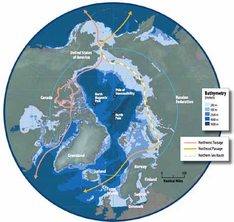
16   CSBA | SECURING THE FRONTIER

     that connect the Pacific and Atlantic Oceans via the Arctic: The Northern Sea Route along the
     Russian coast, the Northwest Passage along the Canadian coast, and a third route across the
     North Pole (see Figure 3). Of these, the continued presence of ice floes in the mid-Arctic Ocean
     and along the Northwest Passage will likely make them less reliable than the Northern Sea
     Route. The Northwest Passage will likely be affected by ice even after the mid-Arctic becomes
     ice-free in summer because it consists of a series of narrow channels.49

     Arctic traffic falls into one of two categories: transit traffic or destination traffic. Transit traffic
     refers to ships that pass through the Arctic on their way from a non-Arctic embarkation point
     to a non-Arctic destination.50 Destination traffic refers to ships whose destination is an Arctic
     port and whose point of origin may either have originated in the Arctic or outside the Arctic.
     Historically, most Arctic shipping has constituted destination traffic.

     FIGURE 3: ARCTIC SHIPPING ROUTES

     Map Source: Protection of the Arctic Marine Environment (PAME), Arctic Marine Shipping Assessment, 2009 Report (Iceland and Norway: The
     Arctic Council, 2009), available at https://www.pmel.noaa.gov/arctic-zone/detect/documents/AMSA_2009_Report_2nd_print.pdf.

     49    Ibid., p. 13.

     50    Frederic Lasserre et al, “Polar Seaways? Maritime Transport in the Arctic: An Analysis of Shipowners’ Intentions II,”
           Journal of Transport Geography 57, December 2016, p. 107.
www.csbaonline.org 17
The Northern Sea Route is between 2,200 and 2,900 nm long and skirts Russia’s northern
coast between Murmansk in the west and Provideniya in the east. First navigated by the
Swedish scientist A.E. Nordenskjold in 1879, the Northern Sea Route has been vital to the
sustainment of Russia’s many northern Siberian communities and the resource extraction
industries that they support. At the height of economic activity on the Northern Sea Route in
the 1980s, the Soviet Union operated an Arctic fleet of almost 700 ice-hardened vessels and
38 icebreakers, including six nuclear icebreakers.51 However, the economic collapse Russia
experienced following the dissolution of the Soviet Union dramatically reduced the amount of
investment in Northern Sea Route communities and businesses, and the volume of Northern
Sea Route shipping fell by 77 percent between 1987 and 1998.52
The last several years have seen a steady, but not dramatic, uptick in Northern Sea Route
shipping as Russia has sought to reinvigorate its Arctic economic program. Transit and desti-
nation shipping traffic there are constrained by recent sanctions, the route’s shallow depth,
and weather. Nevertheless, shipping traffic grew by 35 percent between 2015 and 2016 and is
predicted to reach 75 million tons a year by 2025.53 By comparison, the Panama Canal moved
330.7 million tons of transit shipping in 2016.54 Of the 7.33 million tons of cargo moved via the
Northern Sea Route in 2016, 3.5 million tons were oil and oil products; 3.4 million tons were
other dry cargo; 114,000 tons were related to liquefied natural gas (LNG) extraction; 220,000
tons were coal; and 55,000 tons were ore concentrate.55
The Northwest Passage runs through the Canadian Archipelago between Baffin Bay in the
east and the Beaufort Sea in the west. Northwest Passage routes that pass north of Banks or
Victoria Islands can generally be thought of as the northern routes and are shorter than the
more circuitous southern route passing through Amundsen or Coronation Gulfs. However,
the northern routes are also more prone to blockages by ice. They first opened to unaided
navigation as recently as 1998.56 The southern routes have been intermittently open since
the 1970s, but they are narrower, shallower, and longer than the northern routes and there-
fore less appealing for trans-Arctic shipping.57 Less resource extraction occurs at Northwest
Passage ports than along the Northern Sea Route. Therefore, the Canadian government has
never prioritized Arctic infrastructure development in the same way as the Soviet and Russian
51 Ostreng et al., Shipping in Arctic Waters, p. 19.
52 Ibid., p. 19.
53 “Traffic Volume on the Northern Sea Route Increased in 2016,” Centre for High North Logistics (CHNL), Information
Office, February 2, 2017, available at http://www.arctic-lio.com/node/264. The source of CHNL’s information is the
Russian news repository site PortNews, available at http://portnews.ru/news/.
54 See “Panama Canal Records Third Highest Annual Cargo Tonnage in Fiscal Year 2016,” Panama Canal Authority press
release, October 20, 2016, available at http://www.pancanal.com/eng/pr/press-releases/2016/10/20/pr610.html.
55 “Traffic Volume on the Northern Sea Route Increased in 2016,” CHNL.
56 Anne Casselman, “Will the Opening of the Northwest Passage Transform Global Shipping Anytime Soon?” Scientific
American, November 10, 2008.
57 Tom Di Liberto, “Northwest Passage Clear of Ice Again in 2016,” ClimateWatch Magazine, September 16, 2016.18 CSBA | SECURING THE FRONTIER
governments. Consequently, the Northwest Passage has lower traffic levels than the Northern
Sea Route and is considered less viable as a future trans-Arctic shipping route.58
The Transpolar Route goes directly across the Central Arctic Ocean. As such, the majority
of the route does not fall within the territorial bounds of any of the Arctic states. At present,
only icebreakers are able to navigate to the North Pole and, with one exception, only during
summer months.59 Some predictions assess that ocean warming could allow unaided naviga-
tion in ice-diminished conditions on the Transpolar Route by the middle of this century.60
The navigable season for Arctic sea lanes is generally from June to October, when the ice melts
Figure 4
sufficiently to allow passage of conventional or ice-hardened vessels at lower latitudes and
icebreakers at higher latitudes. The changes to Arctic sea ice mass and volume described in
Chapter 1 have resulted in an expanded season in many parts of the Arctic, which has subse-
quently increased shipping traffic (see Figure 4).
FIGURE 4: ARCTIC SHIPPING ACTIVITY
500
450
400
350
300
250
200
150
100
50
0
2009 2010 2011 2012 2013
NSR transits Bering Strait transits U.S. arctic annual traffic
Data from Alyson J. Azzara et al., A 10-Year Projection of Maritime Activity in the Arctic Region (Washington, DC: The International Council on
Clean Transportation, January 1, 2015), p. 23.
The savings from shipping via the Arctic could be substantial. Using the Northwest Passage or
Northern Sea Route can reduce the travel time from the Atlantic to Pacific by four to ten days,
saving hundreds of thousands of dollars in fuel and personnel costs.61 However, cost savings—
and interest in Arctic shipping routes—are affected by the same oil prices that affect petroleum
58 Ostreng et al., Shipping in Arctic Waters, p. 30. Fraunhofer Gesellschaft (FhG), “Safe Navigation Through the Northwest
Passage,” Phys.org News, November 3, 2016, available at https://phys.org/news/2016-11-safe-northwest-passage.html.
59 Ostreng et al., Shipping in Arctic Waters, p. 34.
60 Jugal K. Patel and Henry Fountain, “As Arctic Ice Vanishes, New Shipping Routes Open,” The New York Times, May 3, 2017.
61 Ed Struzik, “Shipping Plans Grow as Arctic Ice Fades,” Yale Environment 360, November 17, 2016, available at http://
e360.yale.edu/features/cargo_shipping_in_the_arctic_declining_sea_ice.www.csbaonline.org 19
exploration in the Arctic. The savings from using Arctic routes decreased as oil prices dropped
over the last several years.62 When oil prices rebound over the next five to ten years, interest in
these routes is likely to increase again.
The Arctic is also becoming more popular with tourists who will travel on these same routes.
In 2005, only 11 cruises travelled through the Arctic. In 2015, 45 cruises made an Arctic
voyage.63 Oil price fluctuations are unlikely to significantly affect cruise traffic, which is
expected to increase in volume and reach to include expeditions to northern Greenland,
Norway’s island of Svalbard, and Russia’s Arctic national park.
The number of Arctic cruise passengers originating in Svalbard, Jan Mayen, Greenland,
Canada, and Russia climbed from just over 50,000 in 2005 to over 70,000 in 2015.64 Most
Arctic passenger ships have remained in the high latitudes of the North Atlantic rather than
undertaking a trans-Arctic passage. However, some vessels do operate further north. In 2016,
the cruise liner Crystal Serenity became the largest cruise ship to navigate the Northwest
Passage. A second Arctic voyage has been scheduled for the ship in August 2017, and there are
currently between 15 and 20 ice-strengthened cruise vessels on order by various cruise opera-
tors.65 In addition to dedicated cruise ships, Russian polar icebreakers also host passengers on
Arctic sightseeing tours.
In short, the quantity of Arctic shipping traffic is likely to grow in the future as the volume of
Arctic sea ice diminishes. A reduction in sea ice would open Arctic routes to navigation for
longer periods than they are open today, potentially allowing shipping companies to make
use of Arctic routes that could reduce cargo transit times. Increased natural resource explo-
ration and extraction and overall growth in the global economy could also lead to additional
shipping traffic.
A study conducted by the U.S. Committee on the Marine Transportation System in 2015
projected vessel activity growth in the U.S. Arctic region (comprising the northern Bering Sea,
the Bering Strait, and the Chukchi and Beaufort Seas to the Canadian boundary). The study
evaluated current Arctic shipping trends and examined different scenarios for global economic
growth and Arctic development, then derived three estimates for vessel traffic increases (see
Figure 5). The projections ranged from a 120 percent to 430 percent increase in the number of
vessels using the Arctic in 2025 compared to 2013 and a 150 percent to 500 percent increase
in the number of Arctic transits in 2025 compared to 2013.66
62 Malte Humpert, “Is Northern Sea Route Shipping in a Deep Freeze?” Arctic Deeply, News Deeply, June 6, 2016, available
at https://www.newsdeeply.com/arctic/articles/2016/06/06/is-northern-sea-route-shipping-in-a-deep-freeze.
63 Struzik, “Shipping Plans Grow as Arctic Ice Fades.”
64 Aaron Lawton, “Cruise Tourism in the Arctic,” Presentation at the 7th Symposium on the Impacts of an Ice-Diminishing
Arctic on Naval and Marine Operations, Washington, DC, July 18, 2017.
65 Lawton, “Cruise Tourism in the Arctic.”
66 Alyson J. Azzara et al., A 10-Year Projection of Maritime Activity in the Arctic Region (Washington, DC: The International
Council on Clean Transportation, January 1, 2015), p. 57.You can also read