Risks to Glaciers and Periglacial Environments at the Cerro Amarillo mining project (Meryllion Resources)
←
→
Page content transcription
If your browser does not render page correctly, please read the page content below
Risks to Glaciers and Periglacial Environments
at the Cerro Amarillo mining project
(Meryllion Resources)
Malargüe Mendoza

by Jorge Daniel Taillant
Center for Human Rights and Environment (CEDHA)

English Translation (original text in Spanish)

Cerro Amarillo
Meryllion Resources
TSX.V : MYR
Publication Date: February 24, 2015
Cover photo: Periglacial environments in the Central Andes feed water basins during dry periods.
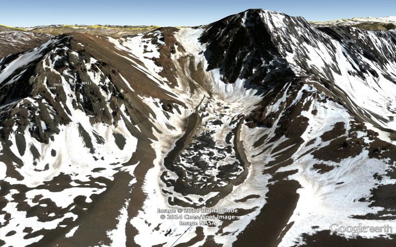
Photo location: Laguna del Cajón Grande (in the heart of the Cerro Amarillo mining concession),
Malargüe County, Mendoza Argentina
Source: Daniel Warenica
Center for Human Rights and Environment (CEDHA)
February 24, 2015
Cordoba, Argentina
Author: Jorge Daniel Taillant
Center for Human Rights and Environment (CEDHA) ©
jdtaillant@gmail.com
Original report in Spanish. In case of discrepancies/differences between translations, the Spanish version prevails.
This report is possible through the generous contribution of:
Unitarian Universalist Service Committee (UUSC)
Patagonia
Acknowledgments
We’d like to thank glacier experts Alexander Brenning, Mateo Martini and Juan Pablo Milana, who are
always available to answer our complex questions regarding the many technical issues that are
addressed in our reports. Alexander and Mateo contributed specifically to the analysis of images in this
report. We would like to thank our teachers, Cedomir Marangunic (Geo Estudios of Chile), Juan Carlos
Leiva (the IANIGLA in Argentina) and Benjamin Morales Arnao (of the Patronato de las Montañas
Andinas, in Peru), and Bernard Francou (of the IRD). They have been our instructors at the several
courses we took under the United Nation’s Environmental Program’s glacier training seminars offered in
2010, 2011, and 2012. Cedomir, Juan Carlos, Benjamin and Bernard have been extremely patient in
answering all of our questions and painstakingly going through the laborious task of teaching us how to
identify glaciers in satellite imagery. We have spent many long hours with each discussing glacier
resources, glacier academics, and learning about the fascinating world of ice, as well as the many risks
these sensitive natural resources face from anthropogenic impacts.
We’d especially like to thank Dario Trombotto Liaudat, a geocryologist of the IANIGLA and member of
the CONICET scientific association, for taking time to answer many technical questions on the
periglacial environment of the Central Andes. Darío answered numerous questions we posed him about
the glacier resources in this report. We also thank Stephen Gruber, of the University of Zurich who has
answered questions about, and explained the uses of, his fantastic permafrost remote modeling tool.
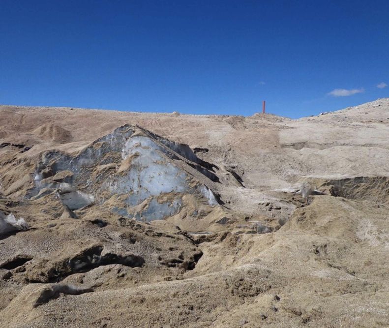
We also thank Daniel Warenica who collaborated with CEDHA on a site visit to the Cerro Amarillo area,
carrying out a photographic documentation of some of the key hydrological resources at the Cerro
Amarillo mining concession. We also thank Mercedes Lu, Heidi Weiskel and Mark Chernaik of ELAW
who helped with the identification of satellite imagery useful for this report.
We must also thank those contributors who have played a fundamental role in financially underpinning
our work, including UUSC (Patricia Jones) and Patagonia (Raul and Cristobal Costa). We also thank the
CEDHA team that collaborated in various parts of this. And finally, Romina Picolotti, who has inspired
this and many other environmental causes.
- Jorge Daniel Taillant
2
Table of Contents
Acknowledgements                                                            2

Recommendations to the Reader                                               4

Preface by Romina Picolotti (former Environment Secretary of Argentina)     5

Executive Summary                                                           7

Background                                                                  9

Access to Satellite Images                                                  9

Characteristics of the Cerro Amarillo Mining Project                        11

Mining History at Cerro Amarillo                                            12

Meryllion Resources                                                         12

Permits, Rights and Activity at Cerro Amarillo                              16

Weather                                                                     18

Hydrology at Cerro Amarillo                                                 18

Glacier and Periglacial Areas Visible by Satellite Images                   19

The Periglacial Environment and Frozen Grounds                              23

Rock Glaciers                                                               29

Water Contribution of the Periglacial Environment                           39

Hydrological Deniers of the Periglacial Environment                         43

Mining Impacts to Glaciers and Periglacial Environments                     44

The Periglacial Environment, Glaciers and Rock Glaciers at Cerro Amarillo   50

Glacier Inventory at Cerro Amarillo                                         51

Preliminary Glacier Inventory by the IANIGLA                                61

Overlap of Mining Activity with Glacier and/or Periglacial Areas            62

Potential Impacts to Glaciers and Periglacial Areas by Cerro Amarillo       66

Conclusions                                                                 67

Bibliography used for this report                                           69

Online Bibliography on Anthropogenic Impacts to Glaciers                    70

About the Author                                                            73


                                                                               3
Recommendations to the Reader:

This report is especially conceived so that the reader can use simple technology to see
glaciers, rock glaciers and periglacial environments, right on their smart devices. Go ahead
and open up your maps program on your phone and set the program to satellite mode.

Type the following string in the search box (comma and all): 35 19 30 S, 70 13 59 W

A white area appears after a few moments … you’re in the Central Andes … right in the heart
of the Cerro Amarillo mining project. Zoom out as needed to gain perspective of the image.
What you’re looking at is a colossal rock glacier containing millions of gallons of water, stored
in ice form ready to be used when the environment needs it most. It looks like a tongue
flowing down the mountain towards the bottom right corner of the screen.

This report is about this and other glaciers in the Cerro Amarillo mining concession.

We can get even more interesting without getting too complicated … download the following
zipped file.

http://wp.cedha.net/wp-content/uploads/2015/02/Cerro-Amarillo-Project-Polygons.kmz_.zip

Save it, and then open it up in Google earth from the file menu in the Google Earth Program.
You’ve now got a glacier inventory of 30 glacier bodies, the mining concession, and other
natural resource references, right in your Google earth program. You can see these glaciers
(or hide them) by simply checking and unchecking the boxes that appear on the left pane in
Google earth.

                       You can see Cerro Amarillo’s Glaciers right on
                       your phone!


                                                                                              4
Preface
by Romina Picolotti
Former Environment Secretary of Argentina

This report appears at a watershed moment in the evolution of the implementation of
Argentina’s National Glacier Protection Law, the first law in the world focused exclusively on
the protection of the planet’s cryogenic resources.

It is an opportune moment to reflect on the fact that only 2% of the world’s water is
freshwater, apt for human consumption. Of that water, ¾ of it is in glaciers, and most of it in
the polar ice caps. The rest is stored in mountain glaciers that in contrast to polar glaciers are
critical water suppliers and water basin regulators for human populations and for agricultural
activity during warmer and drier months. If it weren’t for mountain glaciers and for the
periglacial environment, many of the Planet’s rivers would be seasonal rivers, drying up
quickly once the winter snowfall melts away in the Springtime. Mountain glaciers provide
water year round to rivers and basins that feed humanity, agriculture and industrial activity.

It’s even more surprising to think that before the adoption of Argentina’s National Glacier
Protection Law in the year 2008, approved unanimously by the Argentine Congress, no
country in the world had a law to protect glaciers, a critical natural resource on route to
extinction due to climate change. The reason for this legislative oversight is undoubtedly the
lack of social knowledge about glaciers, the fact that very few people actually live in contact
with glaciers, and the fact that it is very difficult to reach the very inhospitable environments
where glaciers are located and where they thrive. It’s very difficult to protect that which we do
not know. Before the Argentine Glacier Protection Law, few Argentines knew there were
glaciers in provinces like Jujuy, La Rioja, Salta, San Juan, and even in Tucumán—all known
to have very dry climates. These glaciers play a fundamental role in these provinces’ local
water systems.

However, that year, Argentine legislative representatives worked in tandem and with the
Environment Secretariat, responding to the call on lawmakers to protect this vulnerable
resource. Not one of these congressional representatives doubted the importance of this
resource and none of these representatives raised any points of concern over the proposed
glacier protection bill. The world’s first glacier protection law was approved unanimously,
without comments, and without any modification to the proposed text. And yet, just a few days
later, the President of Argentina vetoed the law. She was pressured by large mining interests,
specifically by the owners and interested commercial stakeholders of a very large binational
mining project called Pascua Lama owned by the world’s largest gold miner, Barrick Gold.
The President of Argentina vetoed the glacier law on the grounds that prohibiting mining in
glacier and periglacial areas was “excessive”. She also argued that it wasn’t necessary to
carry out special environmental impact studies where mining was potentially impacting
glaciers. She argued that provinces were in the best position, and were the ideal actors to
monitor and control mining operations that could harm glaciers and periglacial environments.

I resigned from my position as National Environment Secretary at that time because I felt that
the decision of the President was not a good one. I had worked personally from the
Environment Secretariat, and hand in hand with congressional representatives, to achieve the
legal protection of glaciers that were being dynamited by mining companies. Glaciers were
defenseless before an executive power and before provincial powers that were unable or
unwilling to control mining companies. The State was absent in the face of risks and impacts
to glaciers and periglacial areas. The dominant paradigm was to extract and to pillage
resources at any social and environmental cost. We have the example of La Alumbrera in
Catamarca Province to show this tendency. I believe that before this absolute state of
defenselessness, the State must intervene, especially when what is at stake are strategic
hydrological reserves and the well being of communities in the region. I have been witness,
as a government official, of the unscrupulous behavior of mining companies, as they ignore
their environmental and social responsibilities.

Unfortunately, time has only confirmed what we could see was about to happen at that time.
Mining has continued uncontrolled onto glaciated and periglacial environments. Pascua Lama


                                                                                               5
(Barrick Gold), El Pachón (Glencore Xstrata), Los Azules (McEwen Mining), Del Carmen
(Barrick Gold/Malbex), Filo del Sol (NGEx Resources), Famatina (Osisko) and many other
mining investments are located in glacier and periglacial terrain, and are operating practically
without environmental oversight.

The provincial authorities, such as the government of San Juan, authorize companies such as
Barrick Gold to move forward with projects like Pascua Lama, when in neighboring Chile, the
same project, on the same land, is stalled by the judicial sector precisely for the impacts to
glaciers and periglacial environments. Meanwhile, national authorities such as the National
Environment Secretariat and the Mining Secretariat fail to comply with the glacier protection
law by failing to provide the IANIGLA with information about where mining is taking place, so
that the priority inventories and studies mandated by law can shed light on mining risks and
impacts to glaciers and periglacial environments.

It has been four years since the promulgation of Argentina’s National Glacier and Periglacial
Protection Law and we have yet to see a single priority inventory nor a glacier impact study
as mandated by Article 15 of the law.

This report by CEDHA is yet another report in a series of reports we have published
specifically with the intent to show society the risks and impacts suffered by the high glacier
and periglacial environments in the Central Andes and other ranges like the Aconquija Range
in Catamarca and Tucuman provinces. The report provides unquestionable evidence that
there is an overlap of mining activity with glaciated and periglacial environments. This is yet
another call for public officials to take warning, and respond to the urgency presented here
and to defend the interests and well-being of communities that depend on glaciers and
periglacial areas for their subsistence. This is an inescapable obligation for public officials.
Inaction has a permanent cost: environmental harm to these sensitive natural resources is
irreversible.

The Mendoza Legislature opportunely stalled the advancement of Meryllion Resource’s Cerro
Amarillo mining project until the appropriate glacier inventory now being carried out by the
IANIGLA is completed. But we must also ensure that the necessary risks and impact studies
are also carried out. We need more in-depth studies on the risks and impacts that could occur
if Cerro Amarillo is to move forward as planned.

The present report is exclusively focused on this project and identifies glaciers and periglacial
environment in the project’s concession and zone of influence. We hope that this report will
contribute to the effective implementation of Argentina’s Glacier Protection Law and to the
necessary strengthening of Argentina’s State of Law, so necessary now with the present
dominance of short-sighted commercial interests that are in frank contradiction with the needs
of our vulnerable home.


                                                                                              6
Executive Summary
The following report aims to bring attention and raise awareness of the risks and impacts that
mining activity at the Cerro Amarillo mining project (by Meryllian Resources) have had or
could have (if the exploration project moves forward) to glacier and periglacial environments
of the delicate hydrological ecosystems of the Central Andes.
While it is true that sometimes (although not always) we need to conduct site visits to confirm
or discard observations made through the analysis of satellite images, the presence of
glaciers and of periglacial environments, and sometimes also of other geoforms of the
periglacial environment, are easily identifiable through the analysis of satellite images. The
confirmed presence of glaciers and rock glaciers at nearby areas (such as Cordón del Plata
an Las Leñas) at similar altitudes is grounds upon which to presume that we could also find
glaciers, rock glaciers and periglacial areas at Cerro Amarillo.
According to CEDHA’s findings at Cerro Amarillo conclude:
• According to a global permafrost mapping tool developed at the University of Zurich,
there is ample possibility of finding frozen grounds in the project’s concession area;
• There is the probability or at least the possibility of finding ice-saturated frozen
grounds in areas where there may not be rock glaciers visible;
• There are at least three areas in the concession with high probability of finding frozen
grounds;
• The majority of the areas that Meryllion Resources has targeted for future drilling are
in areas where there is at least the uncertainty over the presence of frozen grounds;
• We know with absolute certainty that there are ice-saturated frozen grounds in the
concession where we have positively identified active rock glaciers;
In one small rock glacier we have identified in the mining concession, a conservative estimate
suggests that the glacier contains some 2,000,000,000 liters of water (528 million gallons of
water), which if distributed amongst the Argentine population (40,000,000 people), every
Argentine would have drinking water for nearly a month.
If we map out the waterways and their relationship to the principal rivers of the region, we see
that all of the higher areas where we are likely to find ice-saturated frozen grounds (according
to the University of Zurich model), are the birth sites of the various river systems in the
concession. This is not a coincidence. The waterways in the concession area all come from
the periglacial environment!
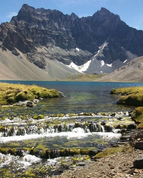
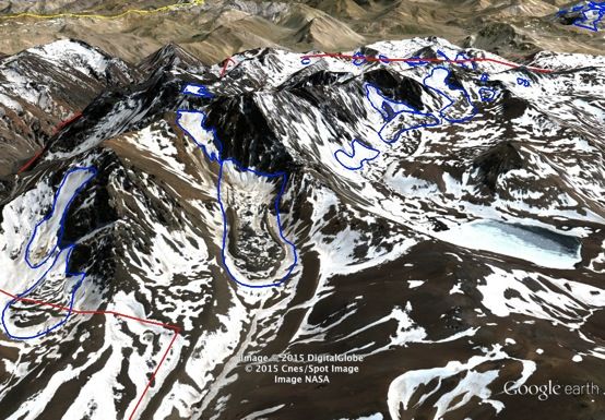
Several lagoons are visible in the heart of the mining concession. These form at the base of
mountain ravines. As these lagoons continue to outflow into local streams after the seasonal
snow has melted, this is undoubtedly due to the permanent and sustained contribution of melt
water from the melting of the periglacial environment above.
CEDHA’s glacier inventory (see image above) registers 30 glacial bodies (amongst these, 13
2 2
uncovered glaciers representing 1.15 km (.44 miles ) and 17 rock glaciers representing
2 2 2 2
2.58km (1 mile ), for a total area of 3.73km of ice (1.44 miles ) in the Cerro Amarillo mining
concession. These glaciers are located at between 2,740 – and 3,690 meters (9000 – 12,100
ft). Argentina’s national glacier institute (the IANIGLA) is still working on an official glacier and
periglacial environment inventory, including uncovered glaciers and of some of the geoforms
of the periglacial environment, such as rock glaciers. However, the IANIGLA will ignore other
very relevant ice-saturated cryogenic resources, such as ice-saturated creeping grounds,
which are also very significant hydrological resources and which are protected by law.
Further, the official inventory will only register glaciers with an aerial surface area of more
2
than 0.01km or 100 x 100 meters (328ft x 328ft) despite the fact that these ice patches can
collectively be even more significant in terms of water contribution than larger glaciers, and
also despite the fact that these ice bodies (prevalent in the Cerro Amarillo concession), are
still very much protected by the Argentine National Glacier Law.
7
According to the information CEDHA has obtained regarding recent and proposed activity for
future mining activity at Cerro Amarillo, combined with the satellite images we have analyzed
and which are presented in this report, we can say that effectively there are coincidences
between past mining activity, and with present or planned future mining activity with areas
that have glaciers, rock glaciers or other periglacial features.

Mining activity can impact glaciers, rock glaciers and periglacial environments due to the
introduction of roads, ground removed by excavation, drilling, blasting, traffic and other
industrial contamination from mining activity. Further, the various stages of mining work
(prospecting, exploration, preparation, extraction, closure) each have diverse and different
impacts. While according to the reports by the company, there has only been light exploration
at Cerro Amarillo, carried out by horseback, on foot, and by helicopter, CEDHA is concerned
over the risks that would be implied if new stages of exploration are to move forward, such as
drilling, moving of soil, introduction of roads, prior to the necessary inventories and glacier
and periglacial impact studies.

Given that the company has already announced its intention to drill and the specific drill sites
where it wants to drill, and that we have already identified the location of glaciers, rock
glaciers and periglacial environments, there is enough information present to warrant an in-
depth study of eventual risks and impacts of these activities to these resources. Of special
concern would be: any drilling on ice-saturated frozen grounds; any movement of soil on ice-
saturated frozen grounds; any introduction of roads on ice-saturated periglacial environment;
any blasts upwind of uncovered glaciers; any introduction of roads upwind of uncovered
glaciers;

It is CEDHA’s recommendation that no further permits be authorized for activities at Cerro
Amarillo until the appropriate inventories and impact studies are completed and that these
studies assure that glaciers, rock glaciers, and other hydrological resources of the periglacial
environments (such as creeping grounds, etc.) are not at risk.

The Argentine National Glacier Protection Law is very clear over the importance of cryogenic
resources, and establishes the categorical prohibition of activities that might damage this
resource. What we need to gauge, hence, is if the activity proposed by the Cerro Amarillo
mining project will negatively impact glaciers, rock glaciers or periglacial areas. If it does, it is
illegal. If it doesn’t then it could legally move forward (at least as concerns glacier protection).

CEDHA calls on public officials, provincial and national authorities specialized in
environmental and mining issues, particularly the IANIGLA, the Environment Secretariat and
the Mining Secretariat, to ensure that the proper studies are carried out to shed light on the
risks to glaciers, rock glaciers and periglacial environments at Cerro Amarillo.

This report by the Center for Human Rights and Environment (CEDHA), offers very clear and
certifiable information, showing that there are cryogenic resources (glacier resources) inside
the Cerro Amarillo mining concession. CEDHA shows without a doubt that there are glaciers,
rock glaciers and periglacial environments in the Cerro Amarillo mining concession. All of
these resources are protected by law. CEDHA cannot see, nor does it know of any special
environmental impact study to assess risks to these glacier and periglacial resources by
Meryillion Resources or by any another company or agency. It is time for the State authorities
to take the necessary steps to ensure the protection of this very vulnerable and strategic
resource.


                                                                                                  8
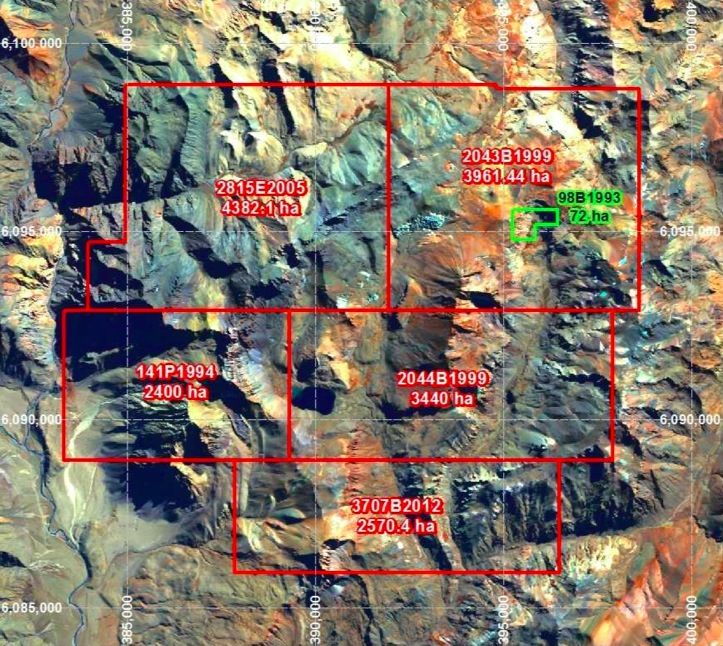
Background

The following report aims to bring attention and raise awareness of the risks and impacts that
mining activity at the Cerro Amarillo mining project (by Meryllian Resources) have had or
could have (if the exploration project moves forward) to glacier and periglacial environments
of the delicate hydrological ecosystems of the Central Andes.

The author is concerned with this potential impact because the project concession is known
to be in, or near, glacier and periglacial areas. Argentina’s laws in force at present prohibit
activities that can harm glaciers or periglacial environments, and expressly prohibits mining in
glacier and periglacial areas. Public officials in charge of controlling mining operations and
ensuring compliance with Argentina’s environmental laws, should be warned and refrain from
granting permits for any mining activity in the Cerro Amarillo concession until the official
glacier inventories and proper impact studies have been completed.

Public information available online indicate that Cerro Amarillo, located in the county of
Malargue Mendoza Argentina, is a gold and copper mining project currently in an initial
exploratory phase and comprises terrain of the Central Andes, including areas of the following
ranges: Apero, Vaca de Cobre, Cerro Choro, Cajón Grande and La Blanca. Below are three
images that help situate the project for the reader. The mining concession is the red polygon.

Cerro Amarillo Project Location (Meryllion Resources)


                                                                                             9
Detail of the concession area – Cerro Amarillo

Detail of the project area; Source Meryllion Resources


                                                       10
According to Meryllion Resources’ website (the company that holds exploratory rights to the
mining concession and who has already conducted exploratory activity at the concession),
the Cerro Amarillo mining project is located in the Central Andes at an average altitude of
3,000 meters (9,842 ft) above sea level, with an altitudinal variance between 2,000 and 3,800
meters (6,561 – 12,467 ft). [see: http://meryllionresources.com/s/cerro-amarillo.asp]

The company notes that there are substantial mineral deposits in the concession, which make
Cerro Amarillo an attractive mining investment. Also according to Meryllion Resources:

                                                      “Much of the project area receives snow from May to November each year resulting in a
                                                                                                                                     1
                                                      practical field season of some five months from early December to late April.”

Meryllion Resources also suggests that there are ample hydrological resources at the
concession. While the presence of snow during the winter months is not necessarily an
indicator that one might find glaciers or periglacial areas present in the area, the continued
presence of that snow beyond the winter months—and the short window of access to the site
due to the cold weather—does. This is at least a preliminary indicator that there may be
glaciers and periglacial areas at or near the site. But more importantly the region is already
known to glaciologists for housing many glaciers and periglacial environments. Periglacial
environments, in contrast to more commonly recognized white uncovered glaciers, are frozen
grounds saturated in ice, that work, much like normal glaciers, as water reserves and as
water basin regulators, providing slow release critical melt water after the seasonal snow has
melted in the spring. This is why the Argentine Glacier Law protects these sensitive
ecosystems.

In a recent report published in 2012, by the Argentine Snow, Glacier and Natural Sciences
Institute (IANIGLA), the area just north of Cerro Amarillo called Cordón del Plata, is
designated as a glacier and rock glacier area, at elevations between 3,200 and 4,100 meters
                     2
(10,500 – 13,500ft).

We should clarify that as one approaches the polar regions, glaciers are found at lower and
lower altitudes, due to which we can presume that without even analyzing satellite images of
the terrain at Cerro Amarillo, as we go further south from Cordón del Plata (Cerro Amarillo is
further South), there is probability of finding glaciers and/or periglacial environments at the
very least at similar altitudes or even at lower altitudes than Cordón del Plata. If we consider
the nearby ski resort of Las Leñas, for example, we can find active rock glaciers as of 2,900m
           3
(9,500ft).

Considering that Cerro Amarillo is between 2,000 and 3,800m (6,500 and 12,500ft), and that
it is further South than Cordón del Plata, and also further South from Las Leñas ski resort, we
can easily conclude that there is a likelihood of finding periglacial environments at Cerro
Amarillo at its average elevation of 3,000 meters (9,840ft). Evidently, each terrain may have
its own micro-climate and these may vary quite a bit from site to site. And while this
supposition is not sufficient to assuredly conclude that there is presence of periglacial areas
at Cerro Amarillo, we can certainly sustain that there is enough probability to warrant a
precautionary approach to the issue, and to mandate all types of industrial activities taking
place in the area to carry out full glacier inventories and glacier and periglacial impact
assessments in order to protect glaciers and periglacial environments.


1
  see: http://meryllionresources.com/s/cerro-amarillo.asp
2
  see: http://www.glaciaresargentinos.gob.ar/informes/MZ_ING_Plata_31_10_13.pdf; p. 24
3
  see for example:
a) 35°08'19.75" S 70°07'20.79" W
b) 35°09'46.54" S 70°09'30.20" W


                                                                                                                                                                                                                                 11
Cerro Amarillo is located more than 250 km South of the Cordón del Plata mountains (where there are
rich periglacial areas), which leads us to presume that is it more than reasonable to presume that there
is likely to be periglacial environments at similar altitudes (or even lower) at Cerro Amarillo.
                                                                                                                                                                                                                                   4
While today, in compliance with the National Glacier Protection Law, law number 26.639, a
national glacier and a partial periglacial inventory is underway and being carried out by the
IANIGLA, not all periglacial forms will be inventoried. The IANIGLA glacier inventory will not
fully register all periglacial resources. Furthermore, none of the relevant agencies, the
IANIGLA, the Environment Secretariat, the Mining Secretariat, or the Provincial Authorities,
                                                                 5
have complied with the National Glacier law, as per Article 15 which calls for carrying out
within 180 days of the sanctioning of the law (date which expired in April of 2011), priority
inventories and specialized studies to analyze the potential risks and impacts of industrial
activity such as mining to glacier and periglacial resources. In the case of the Cerro Amarillo
mining project, this study should have been carried out by April of 2011. We are already four
years into the full implementation of the Glacier Protection Law, and no such study has been
demanded or completed, which implies non-compliance of public duties by all of the
responsible agencies and actors.


4
  see: http://wp.cedha.net/wp-content/uploads/2012/10/Argentine-National-Glacier-Act-Traducción-de-CEDHA-no-
oficial.pdf
5
  see: http://wp.cedha.net/wp-content/uploads/2011/04/ley-glacieres-definitiva.pdf

Art. 15. – Transitory Disposition
In a maximum period of sixty (60) days beginning with the sanction of this law, the IANIGLA shall
present to the national implementing authority a chronogram for carrying out the inventory, which
shall commence immediately in such zones where due to the existence of contemplated activities in
Article 6, are considered priority. In these zones, the inventory stipulated in Article 3 shall be carried
out in a period of no more than 180 days.

With respect to the competent authorities, these shall provide all the necessary information
pertinent that the cited institute requires;

The activities described in Article 6, in progress at the moment of the sanctioning of the present law,
must, in a period of no more than 180 days from the promulgation of this law, submit to an
environmental audit in which potential and actual environmental impacts to glaciers are identified
and quantified. In the case of verification of negative impacts to glaciers or the periglacial
environment, contemplated in Article 2, the authorities shall order the pertinent measures so that
the present law is complied with, and could order the ceasing or relocation of the activity and
protective measures, cleaning and restoration as appropriate.


                                                                                                                                                                                                                                     12
It is because of these failures to comply with the law that the Center for Human Rights and
Environment (CEDHA), which has already produced numerous studies examining the impacts
of mining activity to glacier and periglacial areas, is publishing this report, with the aim of
warning of the apparent potential risks and impacts of allowing mining activity to advance at
Cerro Amarillo without first conducting the necessary inventories and official impact studies.
Additionally, this report aims to bring attention to public officials over these risks, offering a
preliminary glacier and periglacial environment inventory of the Cerro Amarillo mining project
concession. This warning and information is directed and especially targeted to the public
officials and legislatures that must decide on the granting of further exploratory or extraction
permits to Meryllion Resources or to any other company that desires to carry out mining
activity in the project concession area. We also advise other public officials, of other national
and provincial agencies that have domain over mining activities, that they must comply with
their due diligence and with the law to ensure the protection of glacier resources in the region.

Access to Satellite Images

In order to carry out a glacier scoping exercise, as well as detailed studies of glacier and
periglacial areas, the most important technical resource needed is good high-resolution
satellite imagery of the area studied, from a series of consecutive years, and preferably from
days without cloud cover or seasonal snow. In such images, one can easily identify glacier
and rock glacier resources (rock glaciers are glaciers with a cover and mix of rock debris). In
some cases, we can also identify other elements of the periglacial environment, as for
example, frozen creeping grounds, which are also hydrologically important resources.

Generally, satellite companies sell these images to interested clients, although they may also
be obtained through publically available internet-based programs such as Google earth.
Public agencies, for example space agencies, may also provide satellite images to interested
parties. In some cases these images can be very expensive, while in others, they may be
offered at no cost, particularly when they are for use for the public interest. In Argentina, the
CONAE (the national space agency), has access to high resolution satellite images. Through
its mandate, the CONAE can sign memorandums of collaboration with public interest groups,
including NGOs, and provide satellite images at no cost.

Unfortunately, when CEDHA began our work in 2010 to study satellite imagery to identify
mining activity affecting glaciers, the political officials of the CONAE, in complicity with the
Environment Secretariat, obstructed CEDHA’s access to these images, arguing that it was
not necessary for an NGO to carry out a glacier inventory, since the IANIGLA was already
preparing a national glacier inventory. This rejection of our request to public access to
satellite images, was not only a violation of CEDHA’s right to access information, but also
shows the national government’s intention to withhold information from society about the risks
of mining operations. It is a blatant non-compliance with, and violation of, the National Glacier
Protection Law.

We recall that this is the same government administration (currently in office at the time of the
publication of this report) that vetoed the National Glacier Law when it first appeared in 2008.
This veto was leveraged by companies like Barrick Gold and other interests in the mining
sector, including pressure from the National Mining Secretariat and by executive officials from
mining provinces such as San Juan, Catamarca, La Rioja, and Jujuy. This is not the
subjective opinion of the author of this report, but rather, it is the actual justification cited by
                                                                                                   6
the president’s office when she vetoed the unanimously approved Glacier Protection Law.

We also recall that at that same time, then Secretary of Environment, Romina Picolotti, now
acting president of CEDHA, resigned from her position as Environment Secretary, because of
the President’s refusal to provide federal protection to glaciers and their hydrological
functions. The present negligent acts of the government with regards to the protection of


6
       see (in Spanish only): http://www.infoleg.gov.ar/infolegInternet/anexos/145000-149999/146980/norma.htm


                                                                                                                                                                                                                                 13
cryogenic natural resources (ice resources) and its lack of will to implement the national
glacier protection law, demonstrated on numerous occasions since its adoption in 2010, and
by failing to comply with the dates established for the realization of priority inventories and
glacier and periglacial impact studies, is showing lamentable complicity by the national
government with the many violations we are seeing to the national glacier law by a number of
mining companies in the high Central Andes, including Barrick Gold, Glencore Xstrata,
McEwen Mining, NGEx Resources, Stillwater, and others.

Regardless of the national government’s refusal to grant CEDHA access to satellite images,
we have been able to obtain these images from a variety of other sources, including Google
earth, other space agencies, and through personal and institutional collaborators with our
initiative. With these images, we have been able to conduct our own glacier and periglacial
environment inventory.


                                                                                          14
Characteristics of the Cerro Amarillo Mining Project

According to the mining company Meryllion Resources, the Cerro Amarillo mining concession
          2
is 168km (65 square miles) large and is located at an average elevation of 3,000 meters
(9,800ft), with a varying elevation between 2,000 and 3,800 meters (6,500 – 12,500ft).

The concession is about 60km (37 miles) to the North East of the city of Malargue and at only
10km (6 miles) as a crow flies from the ski resort, Las Leñas. We should also mention that the
Las Leñas ski resort is also located on periglacial environment, including various active as
well as inactive rock glaciers. As such, and considering its current site, Las Leñas ski resort is
also mandated by law to carry out a glacier impact study for activities at the ski resort.

The heart of the Cerro Amarillo mining concession is approximately at the following
coordinates (visible on your smartphone is satellite mode):

35 18 12 S, 70 11 27 W


                                                                                            15
Mining History at Cerro Amarillo

The Cerro Amarillo mining property was first discovered by Minera Aguilar (St. Joe Minerals)
in 1970. Solitario conducted studies and additional sampling in 1994-95 at the Cajón Grande
area. In 1995-96, Phelps Dodge carried out additional mapping and in the years 1996-97,
BHP Billiton carried out further exploratory work. In 1998, Billiton conducted magnetic
mapping at the concession and in 1999, IMA repeated Aguilar’s original activities. The
property was later explored by MIM/Xstrata. In 2006 Latin American Minerals carried out
additional exploration and in 2008-2009 Constitution Mining also undertook mapping. Finally,
in 2011-2014 Meryllion Resources continued the task of mapping Cajón Grande and carried
out prospecting activity at La Blanca and later at Vaca de Cobre and Cerro Choro, Cerro
Apero and Cajón Grande.

Meryllion Resources

Meryllion Resources is a Canadian mining company listed on the Toronto Stock Exchange
(TSX Venture Exchange: MYR) operating in Argentina under the subsidiary name Meryllion
Minerals Corporation (MMC) and Meryllion Argentina, SA (MAS) and holds mining rights in
Argentina over two mining projects, Cerro Amarillo and Providencia (in Jujuy Province).
                                                                                                                                                                                                                                   7
In July of 2014, Meryllion Resources published a technical report (which has extensively
informed CEDHA’s report) and presented the same year, an environmental impact study to
the Province of Mendoza (a study which CEDHA could not obtain, despite requesting the
report to Meryllion Resources).

While CEDHA offered Meryllion Resources the opportunity to comment on the findings of this
report, and on CEDHA’s glacier and periglacial inventory, the company has decided not to
exercise this opportunity at this time.

Permits, Rights and Activity by Meryllion Resources at Cerro Amarillo

In Meryllion’s Techical Report on Cerro Amarillo, the company indicates that it has bought
mining rights and has an option to buy the rights for the Cerro Amarillo concession from Jorge
                                8
Bengochea and Lydia Espizua, and has paid the sum of US$300,000 during the years 2010
through 2014. The company must pay an additional US$400,000 for the 2015-2016 period. If
the company later intends to extract minerals from the concession, it must pay an additional
US$2.5 million to the owners of the mining rights and will also pay the owners an additional
1% of the earnings of the concession. The mining company also has surface rights granted
                                                                                        9
by the company Las Leñas, SA, which operate the nearby ski resort of the same name.

According to the information obtained on the website of the company, to date, the following
activity has been carried out at Cerro Amarillo during the 2011/2012 and 2012/2013 seasons:

                           •                          prospecting and sampling over much of the property;
                           •                          detailed mapping over Cerro Apero, Vaca de Cobre, Cerro Choro, Cajon Grande,
                                                       and La Blanca;
                           •                          geochemical sampling on grids over Cajon Grande and Vaca de Cobre as well as
                                                       talus sampling along scree slopes and crests at la Blanca and Cerro Choro;
                           •                          induced polarisation surveying over Cajon Grande and Cerro Apero; and,


7
  see: http://meryllionresources.com/i/pdf/reports/CA_43-101.pdf
8
  Lydia Espizua is a geologist and glacier specialist working for the IANIGLA. The glacier staff of the IANIGLA is the
team that carries out the glacier inventory, including the inventory of glaciers in the Cerro Amarillo concession. This
apparent conflict of interest between IANIGLA’s staff carrying out the glacier inventory and the financial loss for one
of those staff that would be implied should the IANIGLA determine there are glaciers in the concession which as a
consequence might imply the illegality of the project, was brought to the attention of the IANIGLA by CEDHA. In
response to our concern, the IANIGLA sustained that Lydia Espizua is not participating in the inventory of glaciers in
the Cerro Amarillo concession.
9
  Technical Report on the Cerro Amarillo Project. Pp. 4-5 y 4-6


                                                                                                                                                                                                                                     16
• helicopter-borne magnetic and radiometric surveying over the entire Cerro Amarillo
property.
There are no visible roads inside the mining concession, restricting access to the concession
site. Meryllion Resources indicates that its work at the concession to take samples has been
carried out on horseback and by helicopter, which would coincide with the analyzed satellite
images which do not show roads entering the concession.
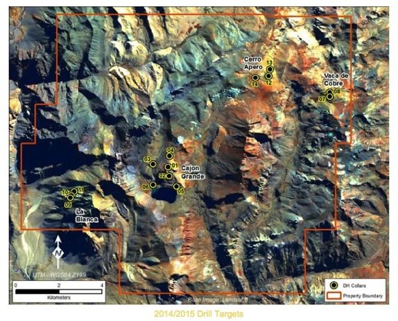
Given the good results from sampling activity, the company intends to advance to a drilling
phase of exploration in which it would perforate some 5,300 linear meters (17,400ft) of
grounds at 14 different locations throughout the concession. Below is a map of the projected
sites for drilling (this information was published by Meryllion Resources).
According to Mendoza Province’s laws, the company must obtain permits to operate and for
continued drilling from the Mendoza Legislature. The Mendoza Legislature recently stopped
all activity at Cerro Amarillo, refusing to grant Meryllion’s permits for further work, until the
10
IANIGLA completes its glacier and periglacial inventory. Meryllion Resources announced in
a more recent press release, dated December 1, 2014, that it:
“After evaluation of recently obtained information regarding the current status of the DIA [its’
environmental impact study], the Company has concluded that it is unlikely it will be able to
11
undertake its anticipated 2015 drill program at Cerro Amarillo”.
Climate
The majority of the surface of the concession receives snow during the months of May
through November, which leaves only the months of December through April for mining
activity.
Hydrology at Cerro Amarillo
The company indicates that the area of the concession has ample hydrological resources,
12
both inside the concession as well as from the Rio Grande basin, to the West.
The concession is located principally on the Rio Grande Basin, and one portion (the North
East) feeds the Rio Salado Basin through the El Desecho stream. The concession includes
four principal ravines, El Cajón de los Oscuros in the North East, the Cajón Grande, the
Cajón Chico and the Cajón del Infiernillo to the South. There is a lagoon at the foot of the
Cajón Grande called Laguna del Cajón Grande.
10
see:
http://www.portalminero.com/display/NOT/2014/10/21/Mendoza,+se+frena+el+proyecto+Cerro+Amarillo+y+avanza+
Hierro+Indio
11
see: http://www.marketwired.com/press-release/drilling-permit-update-regarding-meryllions-cerro-amarillo-project-
in-argentina-tsx-venture-myr-1972927.htm
12
see: http://meryllionresources.com/s/cerro-amarillo.asp
17
N
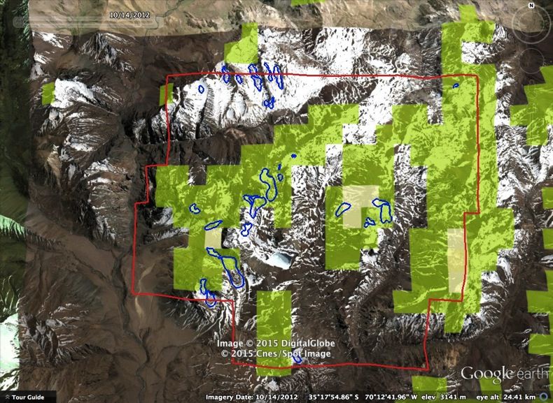
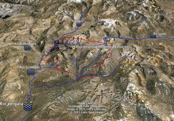
The Cerro Amarillo concession (red polygon) and the principal rivers in its vicinity.
Source: CEDHA/Google earth
The rivers and streams that feed the environments in the concession, also feed key
hydrological basins, principally of the Río Salado and the Río Grande (which is also an
affluent of the Río Colorado). The Río Atuel also receives water from these rivers and
streams. These rivers provide significant volumes of water to communities in the provinces of
Mendoza, Neuquén, Río Negro, La Pampa and to part of Buenos Aires province. The Río
Grande is Mendoza’s most plentiful river.
Glacier Environments Visible in Satellite Images
A first point of clarity, important to sustain the work presented in this report, is to explain the
value of satellite images to the identification and inventorying of glaciers and periglacial
environments. This point is particularly important as a number of individuals, principally in the
mining sector, have suggested that the identification of glaciers from satellite imagery is
13
merely “desktop work” and has no validity if it is not accompanied by site visits.
This affirmation by representatives of the mining sector is simply false. We note for example,
the opinion of the most notorious Latin American glacier agency, the IANIGLA, which states:
“The interpretation of satellite images by an experienced operator is considered still the best
method to register high level information about the different types of glaciers. Although
the manual digital registration is a tedious activity, a trained operator who is knowledgeable of
the region, can generally produce precise delineations of very trustworthy quality.” (IANIGLA.
Fundamentos y Cronograma … p. 34; bold is added)
While it is true that sometimes (although not always) we need to conduct site visits to confirm
or discard observations made through the analysis of satellite images, the presence of
glaciers and of periglacial environments, and sometimes also of other geoforms of the
periglacial environment, are easily identifiable through the analysis of satellite images.
13
This is for instance, the critique made by Javier Ochoa, Chief of Operations for El Pachon (Glencore Xstrata), of
CEDHA’s glacier inventory work for El Pachon. see: http://www.miningpress.com.pe/nota/110863/argentina-
glaciares-ms-cruces-entre-xstrata-pachn-y-la-ong-de-picolotti-
18
In the following image, extracted from the technical report of Cerro Amarillo, published by
Meryllion Resources, taken by the Landsat Satellite, probably during the end of the winter
season (February or March), we can identify some areas with the probable presence of
perennial ice—which would be glacier ice.

A simple definition of glacier ice is ice that lasts for at least two year-long cycles which include
both summers. That is, if the ice on a mountain surface survives for two consecutive
summers, without fully melting, it is considered glacier ice.

We recall that the Glacier Protection Law of Argentina, with respect to the definition of a
glacier, does not establish a size determination for glacier ice. Instead it defines the glacier by
the nature of the ice, indifferent to the size of the glacier:

                                                      Art. 2° – Definition.
                                                      As per the present law, we understand glaciers to be all perennial stable or slowly-flowing ice
                                                      mass, with or without interstitial water, formed by the re-crystalization of snow, located in
                                                      different ecosystems, whatever its form, dimension and state of conservation. Detritic rock
                                                      material and internal and superficial water streams are all considered constituent parts of each
                                                                                                   14
                                                      glacier. (unofficial translation by CEDHA).

We must take into account (and such is the case in the Glacier Protection Law) that a series
of cold winters may recharge mountain areas with snow and ice, and accompanying and
prolonged and sustained cold temperatures will recharge glaciers, and even create new
temporary glaciers, that survive long enough to act as significant hydrological supplements to
the water basin systems, especially during later drier and warmer periods. These “small and
temporary glaciers” are also protected by the Glacier Protection Law.

If we analyze two or three images in distinct sequential years of a same site, we can say that
we see perennial ice if the accumulation of ice year after year, conserves the same form and
shape. With the “time” feature in Google earth, we can see such cases easily. In the following
images, taken from Google earth, we indicate sites of interest with yellow ovals. These would
be areas where ice survives the heat of summer (perennial ice) and would be considered by
definition, glacier ice.


14
   see: http://wp.cedha.net/wp-content/uploads/2012/10/Argentine-National-Glacier-Act-Traducción-de-CEDHA-no-
oficial.pdf


                                                                                                                                                                                                                                 19
Satellite images published by Meryllion Resources show areas of uncovered ice in the Cerro Amarillo
concession. Source: http://meryllionresources.com/s/cerro-amarillo.asp

To get a better idea of the size of these bodies of ice, we can get closer to one of them using
a program like Google earth. In this case we are looking at a small glacier located in the far
Eastern portion of the concession (to the South of Cerro Vaca de Cobre), at the following
geographical coordinates. You can see it on your smartphone quite clearly!

35 17 51 S, 70 07 31 W

In the sequence of images taken from the years 2006, 2010 and 2013, we see that the area
of ice maintains its form quite well, indicating the sure presence of perennial ice.


                                                                                                20
February 2006                                                                                                                                                                                                              March 2010        October 2013

How much water does this relatively small glacier hold?

A quick estimate of the hydrological content of this glacier, supposing an approximate
thickness of 3 meters (it is probably 3 to 4 times as thick or more).
                                                                                                                                                                           2
400m X 200m = 80,000m
                                                           2                                                                                                                                                                       3
80,000m X 3 meters thick = 240,000m
                     3                                                                                                                                                                                                                  15
1m of ice = approximately 1,000 liters of water

so, this glacier holds some 240,000,000 liters of water (or 63 million gallons)

If we consider that per person we consume about 200 liters of water per day (53 gallons), for
drinking, hygiene, and other domestic uses, then this small glacier could provide water to the
entire population of Malargue county –all the people living near the glacier—(population
                                             16
29,000), for more than a month, or 41 days.


15
   In truth, a cubic meter of water holds about 920 liters of water. We have calculated the volume at 1,000 to make
the math easier, however we have greatly underestimated the probable thickness of the glacier to produce a very
conservative estimate of the water content. The likely content is actually several times higher than what we cite!
16
   This calculation is done in the following manner:
240,000,000 liters / 29,000 inhabitants = 8,276 liters per person
4,800 liters / 200 liters per day = 41 days of water.


                                                                                                                                                                                                                                                          21
In the example, we consider a small glacier. But if we pull back from the concession, to the
nearby border of Chile, just to the North or to the West, some 25km kilometers away (15.5
miles), we find very large uncovered glaciers (outside the mining concession), which are very
extensive and massive. This is the case of the next example at the head of the Río Grande
River Basin. In the next image we see the birth of the Río Grande beneath an enormous
glacier that is more than 3km long and wide (about 2 miles long and wide). You can see this
colossal glacier on your smartphone at:

34 59 57 S, 70 18 11 W

It’s pretty big, so you’ll have to zoom out once the image loads, or you’ll be right on the glacier
and not see its magnificent expanse!

                                                                                                                                                                                                                                        3km


Massive glacier at the head of the Río Grande river basin, 15 miles from the Cerro Amarillo concession.

While there are no massive glaciers of this proportion inside the Cerro Amarillo concession,
they are nearby, and we should ask what the impacts may be of volatile debris and dust
deriving from mining operations and entering the airstream in this vicinity. To determine likely
risks and impacts, detailed studies need to be carried out to estimate dust emissions and
corresponding potential impacts on nearby glaciers. Dust accumulated on glaciers darkens
the surface, changing the glacier’s albedo (reflective capacity), and in this way, can cause the
glacier to absorb more heat and accelerate its melt.

Simply by analyzing publically available satellite images, and by the information published by
Meryllion Resources which clearly shows the presence of ice, we can deduce that without a
doubt, there are glaciers present at the Cerro Amarillo mining concession. We will now focus
more in detail on these glaciers.


                                                                                                                                                                                                                                                                                                                                                                                                                                                                                                                                                                                                                             22
You can also read