ZONING ORDINANCE BUILDING CODE SUBDIVISION REGULATIONS SITE PLAN REGULATIONS 2021
←
→
Page content transcription
If your browser does not render page correctly, please read the page content below
ZONING ORDINANCE
      BUILDING CODE
SUBDIVISION REGULATIONS
 SITE PLAN REGULATIONS

 Town of New Castle, New Hampshire

              2021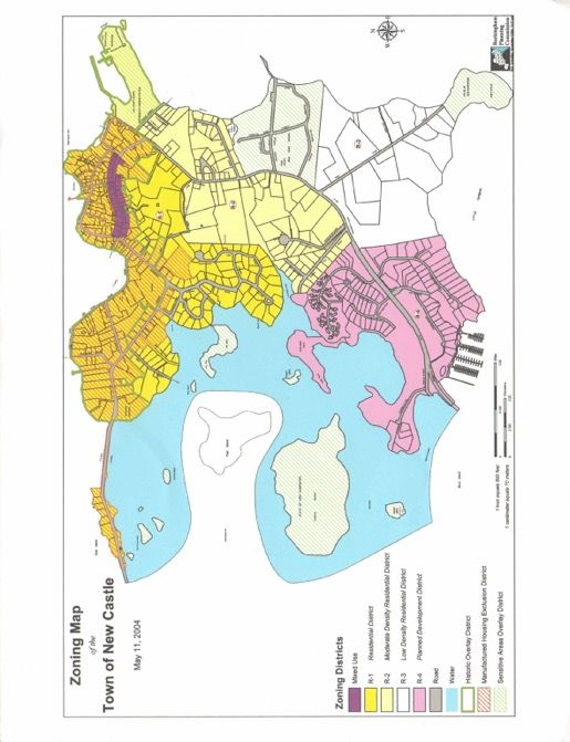
NEW CASTLE ZONING ORDINANCE

               Adopted by

  The Town of New Castle, New Hampshire
                May 2021
AMENDMENT HISTORY
Sections Adopted or Amended May 10, 1994:
1. Section 2.3 - Bed and Breakfast, Accessory Apartment, Home Occupation and Open Space under "Definition of
Terms";
2. Section 6.2: - Home Occupations; 6.2.1 through 6.2.4;
3. Section 6.6 - Accessory Apartments; 6.6.1 through 6.6.5;
4. Section 9.1.1 - Recreational Vehicle under "Definition of Terms";
5. Section 9.1.8b - paragraph iii - Recreational Vehicles.
Sections Adopted or Amended May 9, 1995:
1. Section 2.3 - "Definition of Terms": amendments made to definitions for Basement, Mulitfamily Structure, Parking
Space Right of Way, Structure, Story, Town Engineer; new term added: "Parcel"
2. Subsection 4.2.2 - "Modification and Special Provisions" (of "Dimensional Regulations" section) and Table 1
"Density and Dimensional Regulations": amended with respect to lot coverage;
3. Section 4.3 - "Special Exceptions": amended by combining paragraphs 4.3.2 and 4.3.3 and renumbering the result as
4.3.2;
4. Section 6.2.1 - Amended to include a reference to the special exception criteria of Section 4.3;
5. Section 6.3.1 - Amended to clarify its meaning by inserting the word "any" before "related development...";
6. Section 7.2 - Renamed from "Expansion & Reconstruction" to "Replacement" and deleted the phrase "or expansion"
from paragraph 7.2.1
7. Subsection 9.2.7 - "Special Exceptions for Non-Conforming Lots": replaced subsection with new language.
Sections Adopted or Amended May 14, 1996:
1. Section 2.3 - "Definitions": amend definitions for Coverage, Grade, Height, Structure; new term added: Living Area.
2. Section 4.1.2 - "Residential District": amended list of Prohibited Uses to include paragraph No. 5 regarding
buildings, structures or other devices which restrict access to public or private rights of way.
3. Section 4.2 - "Density and Dimensional Regulations": amended Table 1 to establish a front building setback
requirement in all zoning districts of 20 feet.
4. Section 4.2, Subsection 4.2.2. - "Modifications and Special Provisions": adopted a new provision to establish
maximum living area and minimum roof pitch for the principal structure on a building lot.
5. Section 5.3 - "Streets": adopted replacement language for Subsection(s) 5.3.1 "Acceptance of Streets," 5.3.2 "Right
of Way," and 5.3.3 Parking.
6. Section 6.1.5.1 - "Cluster Development -- Dimensional Standards": amended paragraphs A., B., C. and D.
7. Section 6.1.5.2 - "Lot Size and Density Standards for Cluster Development": amended paragraph C. and added new
Subsection 6.1.5.2.D Credit for Common Open Space.
8. Section 6.1.6.1 - "Provisions for Common Open Space": amended paragraph C to add text regarding Planning Board
approval of area and general layout of open space.9. Section 6.1.7 - "Utilities and Roads": amended No. 4 to reference A Policy on Geometric Design of Highways and
Streets - 1990- AASHTO.
10. Section 6.5 - "Regulations for Swimming Pools," Subsection 6.5.2 amended to update the edition of the National
Electrical Code from 1971 to 1993. Also added a new paragraph No. 9, regarding inclusion of pools in calculations
for allowable lot coverage.
11. Section 6.5.3 - "Signs": Section moved to a new Section 6.7 and text amended.
12. Section 7.2.1 - "Replacement": amended to replace the words "exterior must be a replica or reproduction" with "the
non-conforming portion."
Sections Adopted or Amended May 13, 1997:
1. Subsection 2.3.21 - “Coverage” changed to “Lot Coverage” and definitions renumbered accordingly.
2. Subsection 4.2.2.3 - Maximum % of Lot Covered was redefined for lot size of less than 3500 square feet and lot size
of more than 9000 square feet.
3. Subsection 4.2.2.3 - Added sentence stating that maximum lot coverage for clustered dwellings on undivided lots
will be determined by the Planning Board.
4. Subsection 4.2.2.5 - Added sentence stating that maximum living area for clustered dwellings on undivided lots shall
be determined by the Planning Board.
5. Subsection 6.1.5.2.C - Title of section changed; Inserted “and living area” after the word “coverage” in the second
sentence; Added “and 4.2.2.5" to the end of the second sentence.
6. Section 6.2.3 - First sentence amended to clarify its meaning by adding the word “permanent” after the word “No.”
7. Section 6.5 - Added the sentence “The following regulations also apply to exterior hot tubs and spas.” to the section
heading.
8. Section 6.5.2.4 - Deleted section as was a “rough” duplication of Section 6.5.2.8, and renumbered subsections
accordingly.
9. Section 6.7 - Text of entire section replaced.
10. Section 6.8 - Added as new section.
11. Section 9.2.3 - Reference to NH RSA corrected to “NH RSA 482:A:4.”
12. Subsection 9.3.1.2 - Text of entire section replaced.
13. Section 9.5 - Added as new section.Sections Adopted or Amended February 17, 1998:
1. Section 2.3 - “Hotel Apartments”, added definition, and renumber remainder of section accordingly.
2. Section 4.1.5 - “Uses Permitted by Special Exception”, delete section in its entirety.
3. Section 4.1.5.1 - “Permitted Uses”, amend entire paragraph.
4. Section 4.2.1 - “Density and Dimensional Regulation Chart”, Amend Table 1.
5. Section 5.1 - “Off-Street Parking and Loading”, no changes to Subsection 1 through 11, amend remainder of section.
6. Section 6.1.1 - “Approval Procedure”, delete in its entirety and replace with “Permitted Uses”.
7. Section 6.1.2 - “Uses Permitted by Special Exception”, delete in its entirety and renumber the remainder of section
accordingly.
8. Section 6.1.3.1 - “Hotel and Commercial Use Restrictions”, amend section.
9. Section 6.1.3.2a - Amend section.
10. Section 6.1.3.2c - Amend section.
11. Section 6.1.4 - “Minimum Tract Size and Suitability Requirements”, amend sections 6.1.4.1 and 6.1.4.2.
12. Section 6.1.5.1 - “Dimensional Standards for Residential Cluster Development”, amend section.
13. Section 6.1.6.2 - “Ownership”, amend section with no changes to Sub-Section A, B and C.
Sections Adopted or Amended May 11, 1999:
1. Section 9.3.16 - “Hearing and Notices”, amend section (d).
2. Section 8 - “Building Code Ordinance Fees”, add new section (c), and re-letter existing sections.
Sections Adopted or Amended May 9, 2000:
1. Section 4.3.2 - “Special Exceptions”, amend General Requirements.
2. Section 6.2.2 - “Home Occupations, General Requirements”, amend section.
3. Section 6.3 - “Marinas, Docks, and Piers”, amend 6.3.1.
4. Section 6.6 - “Accessory Apartments”, amend 6.6.1, 6.6.2, 6.6.3, 6.6.4, 6.6.5, and 6.6.6.
5. Section 9.2 - “Wetlands Conservation District”, amend 9.2.4.
6. Section 9.2.9 - “Buffer Provisions”, amend section.
7. Section 9.2.10 - “Natural Woodland Buffer”, amend section.
8. Section 9.2.11 - “Review Process”, amend section.
9. Section 9.3.2.3 - “Historic District Purposes”, amend section.
10. Section 9.3.2.17a - “Historic District Review Criteria”, amend section.Sections Adopted or Amended May 8, 2001:
1. Section 6.3 - “Marinas, Docks, and Piers”, amend 6.3.1, and 6.3.2; add section 6.3.3.
2. Section 9.3.2.14(b) - “Historic District Regulations - Application Procedure”, amend section.
3. Section 10.3 - “Board of Adjustment - Rules of Procedure”, amend section.
4. Section 11.1 - “Schedule of Fees”, amend section.
Sections Adopted or Amended May 14, 2002:
1. Section 6.1.7 - New wording for number 4.
2. Section 6.2 - “Home Occupations”, amend 6.2.2, new wording.
3. Section 6.6 - “Accessory Apartments”, amend 6.6.2, and 6.6.4, new wording.
4. Section 9.3.2 - “Historic District Regulations”, amend 13c, d; 14a, b; add new section 9.3.2, 18, 3
and 4.
Sections Adopted or Amended May 13, 2003:
1. Section 1.0 - “Authority and Purpose”, new wording.
2. Section 2.1 - “Definitions”, Interpretations, new wording.
3. Section 4.2.1 - “Density and Dimensional Regulations”, new wording.
4. Section 4.3.2 - “Special Exceptions”, new section heading and new wording.
5. Section 6.3.2.2-I - “Marinas, Docks and Piers”, new wording.
6. Section 7.0 - “Non-Conforming Lots and Uses”, revises new section heading.
7. Section 7.1.4 - “Non-Conforming Lots and Uses”, amend language.
8. Section 7.3 - “Discontinuance and Abandonment”, revise section heading.
9. Section 7.3.1 - “Discontinuance and Abandonment”, amend language.
10. Section 7.4 - “Change in Use”, revise section heading.
11. Section 7.4.1 - “Change in Use”, revise entire section.
12. Section 9.2.9.2 - Amend language.
Sections Adopted or Amended May 11, 2004:
1. Section 9.3.20 - “Historic District Ordinance”.
2. Section 9.2.9.3 - “Wetlands Conservation District”, add new language.
3. Section 9.3.2.8(f) - “Historic District Ordinance”, add new language.
4. Section 3.0 - “Establishment of Districts”, delete entire section and replace.5. Section 3.3 - “District Boundaries”, delete entire section, it is combined with Section 3.1.
6. Section 4.1 - “Permitted Uses”, delete entire section and replace.
7. Section 4.2.1 - “Applicability of Density and Dimensional Regulations, Table 1”, delete text and replace
Table 1.
8. Section 9.6 - “Sensitive Areas Overlay District”, create new section.
9. Section 7.1.4 - Revise existing section 7.1.4 and recodify section as Section 7.2.
10. Section 9.3.1.2 - “Historic District Overlay”, add new language to modify existing boundary description.
Sections Adopted or Amended May 10, 2005:
1. Section 9.1 - “Flood Plain Development District”, delete paragraph and replace.
2. Section 11.1 - “Enforcement; Fines”, delete section and replace.
Sections Adopted or Amended May 9, 2006:
1. Section 9.2 - “Wetlands Conservation District”, revise entire section.
2. Section 9.5 - “Personal Wireless Service Facility Overlay District”, revise entire section.
Sections Adopted or Amended May 8, 2007:
1. Section 2.3 - Amend definition (Building).
2. Section 2.3 - Add additional definitions (Building Area, Erosion, Sedimentation, Slope, Site Disturbance, and Steep
Slope).
3. Section 4.1.2.3 - Add 3a.
4. Section 4.2.1.1 - Amend “Ground Floor Area – Exempt Structures” and make change Table 1.
5. Section 4.2.1.3 - Amend “Maximum Lot Coverage” and make changes to Table 1.
6. Section 4.2.1.5 - Amend “Maximum Building Area” and make changes to Table 1.
7. Section 4.2.1.7 - Add new section “Building Setback Exceptions for Narrow and Shallow Lots in the R-1, R-2, and
MU Districts” and make changes to Table 1.
8. Section 6.1.4.1.i - Amend section and make changes to Table 1.
9. Section 5.2 - Add new section “Development on Steep Slopes”.
10. Section 6.5.2.7 - Amend section.Sections Adopted or Amended May 13, 2008: 1. Section 2.2 - Amend year of International Residential Code. 2. Section 2.3.13a - Amend definition. 3. Section 4.3.2 - Delete sentence. 4. Section 6.1.4.1 - Amend dimensional standards. 5. Section 2.2.3 - Add definition. 6. Section 9.2.3 - Add new section. 7. Section 9.2 - Delete 9.2.3.2.d; replace 9.2.5.1.d; add 9.2.5.1.e; delete 9.2.6.1; add 9.2.3.2.e; replace 9.2.5.2.g. 8. Section 9.3 - Amend Historic District Ordinance. Sections Adopted or Amended May 12, 2009: 1. Section 2.3.3 - Amend definition. 2. Section 6.6 - Amend Accessory Apartment. Sections Adopted or Amended May 11, 2010: 1. Section 4.1.6 – Amend Prohibited Uses #3. 2. Section 10.3 – Amend with updated language. 3. Section 10.5 – Amend with updated language. Sections Adopted or Amended May 10, 2011: 1. Section 2.2.3 - Add definition. Sections Adopted or Amended May 8, 2012: 1. Section 9.2 – Amend Wetlands Conservation District. Sections Adopted or Amended May 14, 2013: 1. Section 4.1.2 – Amend Residential District (R-1) Permitted Uses. Sections Adopted or Amended May 13, 2014: 1. Section 2.3.36 – Amend definition. 2. Section 9.2.8.4.b - Add definition ‘Turf”. 3. Section 9.2.3.3a – Amend Wetlands Conservation District. 4. Section 9.2.8.4 – Amend Wetlands Conservation District.
Sections Adopted or Amended May 12, 2015:

No Warrant Articles for Zoning Ordinance, Building Code, Subdivision Regulations, or Site Plan Regulations.

Sections Adopted or Amended May 10, 2016:

1.      Section 4.2.1.5 - Amend with updated language and amend Table 1.

2.      Section 5.2.3.1 – Add new subsection “c”.

3.      Section 9.2.5.2 – Add new subsection “j”.

4.      Section 6.1.4.2.d – Amend with updated language.

5.      Section 9.2.11 – Add new Section.

6.      Section 2.3 – Add definition.

Sections Adopted or Amended May 9, 2017:

1.     Section 6.6 – Accessory Dwelling Units – Change wording.

2..    Section 2.3 – Definitions, Subsection 2.3.3 Accessory department to add new section.

3.     Section 9.3.4.2 – Terms of Office in Historic District Commission – New wording.

4.     Section 9.3.4.2.c – To change wording in Historic District Commission.

5.     Section 9.3.7.3 – Hearing and notices subsections a,b,c to change wording.

Sections Adopted or Amended May 8, 2018:

1.     Section 2.0 – Definitions, 2.3.38 Lot Coverage to change wording.

2.     Section 2.3.35 – Impervious surface to adopt.

3.     Section 9.5.9 – Colocation procedures to add new wording.

4.     Section 9.2 – Wetlands conservation district under Section 9.2.5.2 conditions, to add new section.

5.     Section 9.5.5 – Condition uses under Section 9.5.5.1 Conditional use permit to amend.

Sections Adopted or Amended at Special Town Meeting January 20, 2021:

1.     Section 9.1 – Flood Plain Development District. Updated references and language per the updated FEMA Floodplain
        Regulations put into effect on January 29, 2021.
Sections Adopted or Amended May 11, 2021:
1. Section 9.2.5.1.d – Replaced old terminology with Shoreland Water Quality Protection Act
2. Section 9.2.5.1.e – Removed wording requiring ZBA relief for buffer encroachment. Replaced old terminology with
Shoreland Water Quality Protection Act.
3. Section 9.2.9 – Deleted Paragraph regarding Appeals
4. Section 9.2.10 – Deleted Paragraph regarding Review Procedures
5. Section 11.2 – Added new wording regarding appeals
6. Section 11.3 – Added new wording regarding fees
7. Section 5.4.2 – Added new wording
8. Section 6.3 – Deleted wording related to Marinas, Docks and Piers. Added wording for Docks.
9. Section 2.3.13a – Amended language for clarity, added an example and a reference on the accompanying chart.TABLE OF CONTENTS
Zoning Ordinance
SECTION PAGE
1.0 AUTHORITY AND PURPOSE ................................................................................................. Zone–1
2.0 DEFINITIONS ............................................................................................................................ Zone-1
2.1 Interpretations................................................................................................................... Zone-1
2.2 Terms Not Defined ........................................................................................................... Zone-1
2.3 Definitions ....................................................................................................... Zone-1 to Zone-7
2.4 Flood Development Regulation Definitions ..................................................................... Zone-8
3.0 ESTABLISHMENT OF DISTRICTS ....................................................................................... Zone-8
3.1 Establishment and Designation of Districts................................................... Zone-8 to Zone-10
3.2 Zoning Map .................................................................................................................... Zone-11
4.0 DISTRICT REGULATIONS ................................................................................................... Zone-12
4.1 Permitted Uses.............................................................................................. Zone-12 to Zone 15
4.2 Density and Dimensional Regulations and Table........................................ Zone-15 to Zone-19
4.3 Special Exceptions ......................................................................................................... Zone-20
5.0 GENERAL REGULATIONS .................................................................................................. Zone-21
5.1 Off-Street Parking and Loading……………………………………………Zone-21 to Zone-22
5.2 Development of Steep Slopes...................................................................... Zone-22 to Zone-24
5.3 Streets ............................................................................................................................. Zone-25
5.4 Condominium Regulations .......................................................................... Zone-25 to Zone-26
6.0 SUPPLEMENTARY USE REGULATIONS.......................................................................... Zone-26
6.1 Special Regulations for the Planned Development District ........................ Zone-26 to Zone-31
6.2 Home Occupations ......................................................................................................... Zone-31
6.3 Docks........................................................................................................... Zone-32 to Zone-33
6.4 Storage of Hazardous Materials ..................................................................................... Zone-33
6.5 Regulations for Swimming Pools ................................................................................... Zone-33
6.6 Accessory Dwelling Units (ADU)............................................................... Zone-34 to Zone-36
6.7 Signs ............................................................................................................................... Zone-36
6.8 Fences and Walls ............................................................................................................ Zone-36
7.0 NON-CONFORMING LOTS, BUILDINGS, STRUCTURES AND USES......................... Zone-36
7.1 Definitions ...................................................................................................................... Zone-37
7.2 General ......................................................................................................................... Zone-37
7.3 Replacement ................................................................................................................... Zone-37
7.4 Discontinuance .............................................................................................................. Zone-37
7.5 Change to Non-Conforming Lots, Buildings, Structures and Uses ................................ Zone-388.0 RESERVED ............................................................................................................................... Zone-39
9.0 OVERLAY ZONING DISTRICTS ......................................................................................... Zone-40
9.1 Flood Plain Development District ............................................................... Zone-40 to Zone-48
9.2 Wetlands Conservation District................................................................... Zone-48 to Zone-57
9.3 Historic District Ordinance ......................................................................... Zone-58 to Zone-67
9.4 Manufactured Housing Exclusion District ..................................................................... Zone-67
9.5 Personal Wireless Service Facility Overlay District ................................... Zone-67 to Zone-74
9.6 Sensitive Areas Overlay District ................................................................................... Zone-74
10.0 BOARD OF ADJUSTMENT ................................................................................................... Zone-75
10.1 Establishment ................................................................................................................. Zone-75
10.2 Authority and Purpose .................................................................................................... Zone-75
10.3 Rules of Procedure ......................................................................................................... Zone-75
10.4 Hearings and Notices...................................................................................................... Zone-75
10.5 Criteria for Variances and Special Exceptions ............................................ Zone-76 to Zone-77
10.6 Findings of Fact .............................................................................................................. Zone-77
10.7 Limitations on Variances & Special Exceptions ............................................................ Zone-78
11.0 ADMINISTRATION AND ENFORCEMENT ...................................................................... Zone-78
11.1 Enforcement; Fines......................................................................................................... Zone-78
11.2 Appeals…………………………………………………………………………………Zone-78
11.3 Fees……………………………………………………………………………………..Zone-78
12.0 AMENDMENTS, VALIDITY, APPLICABILITY ................................................................ Zone-79
12.1 Validity, Severability...................................................................................................... Zone-79
12.2 Conflicting Provisions .................................................................................................... Zone-79
12.3 Amendments................................................................................................................... Zone-79
12.4 Effective Date ................................................................................................................. Zone-79New Castle Zoning Ordinance
May 2021
ZONING ORDINANCE
New Castle, New Hampshire
1.0 Authority and Purpose
Pursuant to the authority conferred by Chapter 674:16 of the New Hampshire Revised Statutes Annotated, as
amended, and for the purpose of promoting the health, safety, and general welfare of the community and the
intent of the Town Master Plan, this Ordinance is hereby adopted by the Town of New Castle.
2.0 Definitions
2.1 INTERPRETATIONS
Unless otherwise expressly stated, the following words and phrases shall be construed throughout this ordinance
to have the meaning defined in this section. Words used in the present tense include the future; the singular use
includes the plural and the plural use the singular. Headings within this ordinance shall not be construed to affect
the interpretations of the words and phrases of the sections of the ordinance.
2.2 TERMS NOT DEFINED
Where terms are not defined in this section or elsewhere in the Zoning Ordinance, or in the New Castle
Subdivision or Site Plan Review Regulations or other regulations or bylaws of the Town, but are defined in the
2000 International Residential Code, as amended, the 2009 International Residential Code definitions shall be
used. Where terms are not defined in any of the aforementioned sources, such terms shall have ordinary accepted
meanings such as the context of their use implies.
2.3 DEFINITIONS
1. Abandonment: The visible or otherwise apparent intention of an owner to discontinue the use of a
building or premises or the removal of characteristic equipment or furnishings used in the performance of
any nonconforming use without its replacement by similar equipment or furnishings. The replacement of
any nonconforming use or building by a conforming use or building.
2. Abutter: Any person whose property is located in New Castle and adjoins or is directly across the street
or stream from the land under consideration by the local land use board. For purposes of receiving
testimony only, and not for purposes of notification, the term abutter shall include any person who is able
to demonstrate that his land will be directly affected by the proposal under consideration. For purposes of
receipt of notification by a municipality of a local land use board hearing, in the case of an abutting
property being under a condominium or other collective form of ownership, the term abutter means the
officers of the collective or association, as defined in RSA 356-B:3, XXIII.
3. Accessory Dwelling Unit (ADU): A residential living unit that is within or attached to a single-
family dwelling or is located in a detached structure, and that provides independent living
facilities for one or more persons, including provisions for sleeping, eating, cooking, and
sanitation on the same parcel of land as the principal dwelling unit it accompanies.
Zone - 1New Castle Zoning Ordinance
May 2021
4. Accessory Use or Structure: A use or structure subordinate to the principal use of a building on the same
lot and serving a purpose customarily incidental to the use of the principal building.
5. Addition: As applied to a building or structure, means any construction which increases the area or the
height of any portion of the building or structure.
6. Alteration: As applied to a building or structure, means any change or modification in construction,
existing facilities, or permanent fixtures or equipment which does not include an addition to the building
or structure.
7. Approval: see Subdivision Regulations
8. Approval, Conditional: see Subdivision Regulations
9. Area: As applied to a building or structure, means the maximum horizontal projected area of the building
or structure at or above grade.
10. Basement: A story of a building or structure having an aggregate of sixty percent (60%) or more of its
clear height below grade. Also see "Story".
11. Bed and Breakfast: A transient lodging facility which is the owner's personal residence, is occupied by
the owner at the time of rental and in which the only meal served to guests is breakfast.
12. Board: The Planning Board of the Town of New Castle, New Hampshire as established under the
provisions of RSA 673:3 as amended.
13. Building: Means a combination of materials to form a construction that is safe and stable and adapted to
permanent or continuous occupancy for assembly, business, educational, high hazard, industrial,
institutional, mercantile, residential or storage purposes; the term "building" shall be construed as if
followed by the words "or portion thereof". For the purposes of this code each portion of a building
separated from other portions by a fire wall, as defined in the current International Building Code as
adopted by the Town of New Castle, shall be considered as a separate building.
13a. Building Area: The gross floor area of all buildings on a lot including garages, detached buildings and
covered porches and including 50% of the area of walkout basements, but excluding patios and decks.
Storage sheds of less than 80 square feet are also excluded.
Example for a 15,000 Square Foot Lot:
15,000
- 4,000 (50%)---- 2,000
11,000
- 5,000 (25%) ---- 1,250
6,000 (15%)----- 900
4,150 Square Feet Max Building Area
14. Building Coverage: The aggregate or maximum horizontal cross sectional area of all buildings on the lot,
but excluding eaves or gutters projecting not more than thirty (30) inches. Structures less than eighteen
(18) inches above ground level shall not be included in calculating building coverage.
Zone - 2New Castle Zoning Ordinance
May 2021
15. Building Height: See Height.
16. Building Setback Line: The line, established by law, beyond which a building shall not extend, except as
specifically provided by law.
17. Building Official: The officer or other designated authority charged with the administration and
enforcement of this code, or his duly authorized representative.
18. Building, Principal: A structure in which is conducted the principal use of the site on which it is situated.
In any residential district any dwelling shall be deemed to be a principal building on the lot on which the
same is located.
19. Condominium: A fee interest in land or buildings owned by a unit owner, together with an undivided
interest in the common areas of facilities. Condominiums can include single-family or multi-family
dwellings and are managed by a condominium association. The creation of a condominium shall be
considered a subdivision entitled to regulation by the town under RSA 356-B:5.
20. Condominium Instruments: A collective term referring to the declaration, by-laws, site plan and floor
plan, recorded pursuant to RSA 356-B.
21. Dwelling: A building or portion thereof designed or used exclusively as the residence or sleeping place of
one or more persons, but not including hotels, motels, rooms or a boarding house, clubs, lodges, trailers,
or structures solely for transient or overnight occupancy.
22. Dwelling Unit: One (1) or more rooms, including cooking facilities, and sanitary facilities in a dwelling
structure, designed as a unit for occupancy by not more than one (1) family for living and sleeping
purposes.
23. Easement: A non-possessory interest in real property; the right to use another's real estate for a limited
purpose.
24. Erosion: The wearing away of the ground surface as a result of the movement of wind, water, ice, or
from land disturbance activities.
25. Family: Individuals occupying a dwelling unit and living together as a single housekeeping unit and
doing their cooking together; provided that unless all members are related by blood, marriage, or
adoption, no such family shall contain more than five persons.
26. Final Plat: See Subdivision Regulations
27. Frontage: The horizontal distance measured along a lot line dividing a lot from a street. Such
measurement shall refer to a continuous line except where otherwise specified.
28. Grade: With reference to a building or structure, means the average elevation of the ground adjoining the
building or structure on the lowest side. When the ground slopes away from the exterior walls, the grade
shall be established by the lowest points within the area between the building and the lot line or, when the
lot line is more than six (6) feet from the building, between the building and a point six feet from the
building.
29. Gross Floor Area: The sum of the areas of the several floors of the buildings as measured by the exterior
faces of the walls, but excluding the areas of fire escapes, unroofed porches or terraces, and areas such as
Zone - 3New Castle Zoning Ordinance
May 2021
basements and attics exclusively devoted to uses accessory to the operation of the building.
30. Habitable Room: A room or enclosed floor space arranged for living, eating or sleeping purposes, not
including bath or toilet rooms, laundries, pantries, foyers, or communicating corridors.
31. Health Officer: The Health Officer of the Town of New Castle.
32. Height: As applied to a building, means the vertical distance measured from the building line at the
lowest grade on any side, to the highest point of the roof, excluding chimneys and similar projections that
are usually appurtenant to the building.
33. Home Occupation: An occupation, professional activity, or use that is clearly a customary, incidental
and secondary use of a residence and which does not alter the exterior of the property or affect the
residential character of the neighborhood.
34. Hotel Apartment: A hotel unit containing up to two (2) bedrooms and kitchen facilities with a gross
floor area of less than 1,250 square feet. Hotel apartments shall be allowed only as a subordinate and
accessory use to an approved hotel of 150 or more rooms and must be maintained and managed by the
hotel operator. Hotel apartments shall not be used as a residence as defined in this ordinance.
35. Impervious Surface: A modified surface that cannot effectively absorb or infiltrate water, including but
not limited to, decks, patios, driveways, parking areas, walkways, tennis courts, swimming pools, and
hot tubs, unless such structures have been designed to effectively allow for water to infiltrate or be
absorbed. Roofs are always considered impervious surfaces regardless of infiltration systems.
36. Junk Yard: An area of land, with or without buildings, primarily used for the storage outside of a
completely enclosed building, or used and discarded materials, including but not limited to waste paper,
rags, metal, building junk as defined in this article, with or without the dismantling, processing, salvage,
sale or other use or disposition of the same. Junkyard also means any business and any place of storage or
deposit, whether in connection with another business or not, which has stored or deposited two or more
unregistered motor vehicles which are no longer intended or in condition for legal use on the public
highways.
37. Local Land Use Boards: A planning board, historic district commission, inspector of buildings, building
code board of appeals, or zoning board of adjustment established by the local legislative body.
38. Lot: A single parcel of land in the same ownership throughout as shown or defined on a recorded
instrument or defined by metes and bounds and having its principal frontage on a street or on such other
means of access as may be determined in accordance with the provisions of law to be adequate as a
condition of the issuance of a building permit for building on such land.
39. Lot Coverage: That percentage of the plot or land area covered by impervious surfaces
including but not limited to paved, bricked, or gravel areas, buildings, or other structures, decks,
patios, driveways, walkways, sheds, tennis courts, swimming pools and hot tubs.
40. Lot Depth: The mean horizontal distance between the front and rear lot lines.
41. Lot Line: A line dividing one lot from another, or from a street or other public space.
42. Lot of Record: A lot described in a deed which has been lawfully recorded in the Rockingham County
NH Registry of Deeds or which is part of a subdivision plat approved by the Planning Board and lawfully
Zone - 4New Castle Zoning Ordinance
May 2021
recorded in the Registry of Deeds.
43. Master Plan: The comprehensive plan or plan of development for the community.
44. Manufactured Housing: Any structure, transportable in one or more sections, which, in the traveling
mode, is 8 body feet or more in width and 40 body feet or more in length, or when erected on site, is 320
square feet or more, and which is built on a permanent chassis and designed to be used as a dwelling with
or without a permanent foundation when connected to required utilities, which include plumbing, heating
and electrical systems contained herein.
45. Minor Landscaping: Minor landscaping shall mean the placement or installation of landscaping features
that do not involve significant disturbance of soil or require or involve grading of the surface of the land.
For the purposes of the Wetlands Conservation Ordinance the following specific landscaping activities
shall be considered minor: (1) planting of non-invasive plant species; (2) tilling land for a residential
garden with appropriate erosion controls; (3) installation of raised decks which do not meet the definition
of structure as defined herein; (4) repairs to existing structures and facilities and (5) installation of foot
trails or paths that do not concentrate storm water or contribute to erosion.
46. Minor Subdivision: See Subdivision Regulations.
47. Multi-family Structure: Any building which includes three or more residential dwelling units.
48. Non-Conforming Use, Lot or Building: A use, lot or building lawfully existing at the time of adoption
of this ordinance or any subsequent amendment thereto which does not conform to one or more
provisions of this ordinance.
49. Official Map: The adopted street or base map of the municipality as defined in RSA 36:16-18.
50. Open Space: An area that is intended to provide light and air and is used for either environmental, scenic
or recreational purposes. Open space may include, but is not limited to lawns, decorative plantings,
walkways, recreation areas and wooded areas. For the purpose of calculating open space and recreational
area requirements of cluster development, open space does not include driveways, parking lots, open
water or intertidal areas.
51. Owner: A person having legal or equitable title to the property in question.
52. Parcel: A single unit of land in the same ownership throughout as shown or defined on a recorded deed.
53. Parking Space: See Section 5.1, Off-Street Parking and Loading.
54. Permanent Building: Any building resting upon a foundation or otherwise legally defined as "real
estate".
55. Person: Includes an individual as well as a corporation, firm, partnership or other organization or group
acting as a unit.
56. Plat: See Subdivision Regulations.
57. Repair: The replacement of existing work with equivalent materials for the purpose of its maintenance;
but not including any addition, change or modification in construction, exit facilities, or permanent
fixtures or equipment.
Zone - 5New Castle Zoning Ordinance
May 2021
58. Resident; Inhabitant: A person who is domiciled or has a place of abode in the Town of New Castle and
who has, through all of his actions, demonstrated a current intent to designate that place of abode as his
principal place of physical presence for the indefinite future to the exclusion of all others.
59. Residence/Residency: A person's place of abode or domicile. The place of abode or domicile is that
designated by a person as his principal place of physical presence for the indefinite future to the exclusion
of all others. Such residence or residency shall not be interrupted or lost by a temporary absence from it,
if there is an intent to return to such residence or residency as the principal place of physical presence.
60. Right of Way: All town, state and federal highways and the land on either side of same as covered by
statutes to determine the widths of rights-of-way. The term also includes private and other public ways
and the land on either side as stipulated in each specific instance.
61. Rooming and Boarding Houses: A building other than a hotel or motel where lodging is provided for
compensation without individual cooking facilities.
62. Sedimentation: The process by which sediment resulting from accelerated erosion has been or is being
transported from disturbed land into a lake or natural watercourse or wetland.
63. Septic Failure: The condition produced when a subsurface sewage or waste disposal system does not
properly contain or treat sewage or causes or threatens to cause the discharge of sewage on the ground
surface or into adjacent surface or directly into surface waters.
64. Setback: The distance between the nearest portion of a building and a lot or public right-of-way line,
whichever is closer.
65. Sign: Any name, identification, description, display, illustration or device which is affixed to or
represented directly or indirectly upon a building, structure or land in view of the general public and
which directs attention to a product, place, activity, person, institution or business.
66. Site Disturbance: The alteration of the surface of the land, including stripping of vegetative cover from
the land surface.
67. Slope: Slope is the change in elevation over a certain horizontal distance on the earth’s undisturbed
surface, expressed as the percent of elevation change over that distance.
68. Special Exception: A use permitted within a District only after a determination is made by the New
Castle Board of Adjustment that the prerequisite conditions as specified in this Ordinance have been met.
69. Steep Slope: Land with existing slopes greater than 15%. For the purpose of calculating the slope shall be
determined by the average slope from lowest to highest point in the area of a proposed building site.
70. Street: A right-of-way, avenue, road, boulevard, lane, alley, viaduct, highway, freeway and other ways
including a private way offering the principal means of access to abutting properties. A public way
includes the entire right-of-way.
71. Structure: A combination of material to form a construction greater than 18" high, with or without
foundation, that is safe and stable; including among others, buildings, stadiums, reviewing stands,
platforms, stagings, observation towers, radio towers, water tanks and towers, trestles, piers, wharves,
sheds, shelters, and display signs but excluding retaining walls, fences, and other customary landscaping
Zone - 6New Castle Zoning Ordinance
May 2021
elements. The term structure shall be construed as if followed by the words "or part thereof."
72. Story: That part of a building comprised between a finished floor and ceiling above with a minimum
height of 7 feet, 6 inches. A mezzanine shall be considered a story if it exceeds 33 1/3 per cent of the area
of the floor immediately below. A penthouse shall be considered a story if it exceeds 1,000 square feet or
33 1/3 per cent of the horizontal roof area.
73. Subdivider: See Subdivision Regulations.
74. Subdivision: See Subdivision Regulations.
75. Temporary Structure: A structure which, by the type and materials of its construction is erected for not
more than ninety (90) days. Such structures shall include tents, portable band stands, bleachers, reviewing
stands, a mobile home used in conjunction with construction activities, tractor trailers, or other structures
of similar character.
76. Town Engineer: The duly designated engineer of the Town of New Castle or, if there is no such official,
the planning consultant or official assigned by the Board of Selectmen.
77. Turf: Means non-agricultural land planted in closely mowed, managed grasses except golf courses, parks,
athletic fields and sod farms.
78. Variance: A legal permit to depart from the requirements of the Zoning Ordinance as granted by the
Board of Adjustment.
79. Walkout Basement: A basement having the exterior elevation equal to or below the elevation of the
existing basement floor and being accessed through a door or opening at grade level.
80. Wetlands: Areas that are inundated or saturated by surface or ground water at a frequency and duration
sufficient to support, and that under normal conditions do support, a prevalence of vegetation typically
adapted for life in saturated soil conditions. They include, but are not limited to, swamps, bogs, marshes,
ponds, lakes, soils that are defined as Type A (very poorly drained) or Type B (poorly drained) hydric
soils and any area of wetland falling within the jurisdictional definition of N.H. RSA 482-A:4.
81. Yard: Any open area that lies between the principal buildings or group of buildings and the nearest lot
line and is unoccupied by any structure except as herein permitted.
Zone - 7New Castle Zoning Ordinance
May 2021
2.4 FLOOD DEVELOPMENT REGULATION DEFINITIONS
Definitions specific to the Flood Development District are stated in Section 9.1 of this Ordinance.
3.0 Establishment of Districts
3.1 ESTABLISHMENT AND DESIGNATION OF DISTRICTS
The Town is hereby divided into areas as shown upon the New Castle Zoning Map, dated May 11, 2004, hereby
incorporated by reference and made a part hereof.
Such areas shall be designated as: 1. Residential District (R-1); 2. Moderate Density Residential District (R-2); 3.
Low Density Residential District (R-3); 4. Planned Unit Development District (R-4); and 5. Mixed Use District
(MU).
In addition to these, the following overlay zoning districts are designated: 6. Mobile Home Exclusion District
(MHE); 7. Historic Overlay District (HD); 8. Sensitive Areas Overlay District (SA); 9. Telecommunications
Overlay District (TEL); 10. Flood Plain Development District (FL); 11. Wetlands Protection District (WET);
The Districts referenced above are defined as follows:
3.1.1 Residential District (R-1): The Residential District includes the central densely settled area of New
Castle of primarily residential development. Its purpose is to accommodate and support single and two
family residential and permitted accessory uses consistent with the developed village center.
The District is bounded as follows: beginning with and including Goat Island, then easterly to include all
land between Portsmouth, Cranfield, Main and Ocean Streets and the Piscataqua River; also including all
land bounded between Wentworth Road, Pit Lane and Cranfield Street; also including land with frontage
on the following streets: Portsmouth Avenue, Cranfield Street, Laurel Lane, Grist Mill Lane, Davidson
Street, Walton Road, Quarterdeck Lane, Mainmast Circle. Excluded from the Residential District is that
land designated as the Mixed Use District as defined in Section 3.1.5.
3.1.2 Moderate Density Residential District (R-2): This district is designated primarily for single and two
family residential development but with lower development suitability and development density than the
Residential (R-1) District. The District is bounded as follows: All land on the easterly side of Wentworth
Road located between the northerly boundary of Great Island Common and Ocean Street; also land on the
westerly side of Wentworth Road located between Pit Lane to the north, the R-1 District to the west and
the rear lot lines of the lots located to the southwesterly side of Spring Hill Road.
3.1.3 Low Density Residential District (R-3): This district is designated primarily for single family residential
development but with lower development density than other residential districts in order to promote a
development density that is more consistent with the predominant development pattern in the lesser
developed areas of New Castle, including land in proximity to the Great Island Common and Fort Stark.
The Low Density Residential District (R-3) includes the following areas: All land on the easterly and
southeasterly side of Wentworth Road extending from and including the Great Island Common, to the
rear lines of lots accessed on the east side of Little Harbor Road. The R-3 District shall also include all
land north of Ocean Street on the easterly side of Wentworth Road. It shall also include all Islands within
the municipal boundaries except Goat Island, Campbell’s Island and Duck’s Head Island.
Zone - 8New Castle Zoning Ordinance
May 2021
3.1.4 Planned Development District (R-4): This District is intended to permit a variety of uses consistent with
and permitted by the defined development plan for this area, including clustered residential and
resort/hotel uses as approved by the Town.
The Planned Development District shall include the following area: all land on both sides of Wentworth
Road between the Rye Town line to the west, and to the R-2 and R-3 District boundaries on the east.
3.1.5 Mixed Use District (MU): The Mixed Use District is principally a residential district, with certain non-
residential uses permitted by special exception. The purpose is to allow traditional village commercial and
retail uses such as stores, shops and offices where such uses are of limited scale and are compatible with
surrounding residential uses.
The Commercial District is bounded and described as follows: Commencing at a point at the center of the
intersection of the public highways now known as Cranfield Street and Main Street and thence running
North along the center of said Cranfield Street 100 feet to a point; thence turning and running Easterly on
a line 100 feet Northerly from Main Street and parallel therewith to and through Atkinson Street to the
center of Walbach Street; thence turning and running Southerly 100 feet to the center of said Main Street
and continuing 100 feet to a point 100 feet Southerly from the center of said Main Street; thence turning
and running Westerly on a line 100 feet from and parallel with the center line of said Main Street to the
center line of Cranfield Street, (excepting the present Church properties which shall be designated as
residential); thence turning and running Northerly along the center line of said Cranfield Street 100 feet to
the point of beginning.
3.1.6 Manufactured Housing Exclusion District (MHE): is the area within the Residential District where
manufactured housing is prohibited. The District is defined as follows: extending along both sides of
Route 1B from the causeway to the intersection of Main Street and Wentworth Road. The area shall be
one lot deep on the south side of Route 1B and shall extend to the Piscataqua River on the north side. (See
Section 9.4)
3.1.7 Historic Overlay District (HD): The Historic Overlay District is intended to preserve and protect the
buildings and the historical architectural landscape of the historical village center of New Castle. See
Section 9.3 for the District boundary definition and related regulations.
3.1.8 Sensitive Areas Overlay District (SA): The Sensitive Areas Overlay District consists of several unique,
sensitive properties under the control of governmental entities and which have special historic,
environmental, economic and recreational value to the citizens of the Town of New Castle and the State
of New Hampshire.
The District is intended to establish attendant use restrictions that encourage the retention of these areas as
public parks and recreation areas and limit any potential development to a scale and density consistent
with the existing character of use of those properties.
The District shall encompass the following areas: Great Island Common; Fort Stark; the U.S. Coast Guard
Facility, including Battery Farnsworth and Fort Constitution and all other land north of Ocean Street on
the easterly side of Wentworth Road. It shall also include all Islands within the municipal boundaries
except Goat Island, Campbell’s Island and Duck’s Head Island. (See Section 9.6)
Zone - 9New Castle Zoning Ordinance
May 2021
3.1.9 Telecommunications Overlay District (TEL): The Telecommunications Overlay District is established
to preserve the authority of the Town of New Castle to regulate and provide for reasonable opportunity
for siting telecommunications facilities, and reduce adverse impacts that the siting of such facilities may
create.
The District consists of all town owned land within the Town of New Castle except that which is within
the New Castle Historic District. (See Section 9.5)
3.1.10 Flood Plain Development District (FP): is defined as the areas subject to flooding and overlays all other
districts. The intent is to forbid new construction which would result in a danger to life, or an
unreasonable danger to property in the event of flooding whether induced by hurricane or otherwise.
The District consists of those areas so designated by the Federal Emergency Management Agency in its
“Flood Insurance Study for Rockingham County, N.H.” together with the associated Flood Insurance
Rate Maps dated January 29, 2021, which are declared to be a part of this Ordinance. (See Section 9.1)
3.1.11 Wetlands Conservation District (WC): the Wetlands Conservation District is designated to protect the
public heath, safety and general welfare of the community by controlling and guiding the use of land
areas defined as wetlands.
The District is defined by the existence of jurisdictional wetlands as defined by RSA 482-A and NH Code
of Administrative Rules Wt Section 101. Wetlands include all areas that are inundated or saturated by
surface or ground water at a frequency and duration sufficient to support and that under normal
conditions, does support a prevalence of vegetation typically adapted for life in saturated soil conditions.
Wetlands include, but are not limited to, swamps, marches, bogs, and similar areas. (See Section 9.2)
Zone - 10New Castle Zoning Ordinance
May 2021
3.2 ZONING MAP
Zone - 11New Castle Zoning Ordinance
May 2021
3.2.1 Establishment: Except as noted below, the districts herein defined are located and bounded as is shown
on the Zoning Map of the Town of New Castle, dated May 11, 2004, and available for inspection at the
Town Hall. A facsimile of the New Castle Zoning Map is provided on the following page of this
Ordinance.
3.2.2 Condition-defined Overlay Districts: The boundaries of the Flood Plain Development District,
Wetlands Conservation District and Telecommunications Overlay District are defined by the existence of
certain conditions determined by site specific mapping and are not depicted on the zoning map. See their
respective sections in Section 9.0 of this ordinance for further definition.
3.2.3 Interpretation: Where uncertainty exists with respect to the boundaries of a district, the following rules
will apply in all districts except the Flood Plain Development and Wetlands Conservation Districts:
1. Where a boundary apparently follows a property line, it shall be interpreted as such;
2. Where a boundary line is shown following a street or utility, the boundary shall be interpreted as the
centerline thereof, unless otherwise indicated;
3. Where a district boundary line divides a lot, either zoning district shall be interpreted as extending fifty
(50) feet into the adjacent district;
4. In cases of uncertainty about a district boundary, and where not otherwise provided for, the Planning
Board shall determine the exact boundary.
4.0 District Regulations
4.1 PERMITTED USES
4.1.1 General:
The following conditions shall apply to uses in all Districts:
1. Use: No building shall be erected, reconstructed or structurally altered nor shall any building or land be
used for any purpose other than is permitted in the District in which such building or land is located. Any
use not specifically allowed as a permitted use, or as a use permitted by special exception, is prohibited.
2. Principal Building: There shall be no more than one (1) principal building on one (1) lot unless
expressly permitted by other provisions of this Ordinance.
3. Federal and State Lands: The provisions of this Ordinance shall apply and be effective over any area
owned by the United States Government or State of New Hampshire, in the event that such land is
relinquished by the United States Government or State of New Hampshire and transferred by sale or lease
or easement to another public body or to a private entity.
4.1.2 Residential District (R-1):
Permitted Uses
1. Single and two (2) family dwelling structures;
2. Manufactured housing as defined in Section 2.3 except in the manufactured housing Exclusion Zone as
Zone - 12New Castle Zoning Ordinance
May 2021
defined in Section 3.1.6;
3. Garages, workshops, toolsheds, greenhouses and other accessory uses that are customary incidental uses
to the principal permitted use provided they are not used for commercial or industrial purposes;
3a. Structures of 80 square feet or less are permitted to be placed no closer than 5 feet from the rear and side
lot line not abutting a street, providing the structure is on a temporary foundation and is not connected to
utilities;
4. Farming or gardening or other agricultural uses, provided that the particular use is not injurious, noxious
or objectionable to others residing in the same neighborhood;
5. Churches, schools, parks, playgrounds and open land;
6. Parking of not more than one trailer or camper, owned and used by the occupant of a dwelling for
recreational purposes. None shall be occupied without first obtaining a permit from the Selectmen; and
7. Customary home occupations as provided in Section 6.2 of this Ordinance.
Prohibited Uses
1. Junk yards and scrap metal establishments;
2. Trailer camps, overnight cabins, hotels, motels, rooming and boarding houses, public bathhouses, public
dance halls, roller skating rinks, bowling alleys, arcades, moving picture theaters, clubs, societies,
gambling facilities or other places likely to cause the congregation of a large number of people except for
an ecclesiastical or educational purpose;
3. Public garages, automobile repair shops, truck terminals, gasoline stations, animal kennels other than ones
for domestic use, animal shelters or hospitals, livery stables, commercial canneries, rendering plants,
abattoir or other businesses or occupations, the general nature of which are noisy, odoriferous, or likely to
cause vibrations, fumes, smoke or be otherwise objectionable;
4. Outdoor advertising signs or billboards not connected with a local town business. All outdoor advertising
signs not on the premises advertised and all neon and/or flashing signs are prohibited; and
5. Buildings, structures, and other devices that exist to restrict access to public or private rights of way,
including but not limited to, Gate Houses and automatic or manually operated access control gates.
4.1.3 Moderate Density Residential District (R-2):
Permitted Uses
1. All uses permitted in the Residential District.
Prohibited Uses
1. All uses prohibited in the Residential District shall be prohibited in the Moderate Density Residential
District.
Zone - 13You can also read