TYWARDREATH AND PAR PARISH - Neighbourhood Development Plan 2020 -2030 - APPENDIX January 2021 - Tywardreath and Par Parish Council
←
→
Page content transcription
If your browser does not render page correctly, please read the page content below
TYWARDREATH AND PAR PARISH
Neighbourhood Development Plan
2020 –2030

APPENDIX January 2021

This document is to be read in conjunction with:
   • the Neighbourhood Development Plan
   • the Evidence Summary
   • the Sustainability Check (full version)
Contents
Appendix A: Landscape Character Assessment............................................................... 4
Figure 1, Par Estuary Map c.1500 ................................................................................. 5
http://www.luxulyanvalley.co.uk/Luxulyan_Valley_archaeological_survey_1988.pdf .... 5
Figure 2, Land Use Classification Map .......................................................................... 8
Figure 3, Dawson's Map 1804 ..................................................................................... 11
https://www.bl.uk/onlinegallery/onlineex/ordsurvdraw/f/0020sd000000005u00321000.h
tml ............................................................................................................................... 11
Figure 4, Flood Water Map .......................................................................................... 13
Figure 5, Green Spaces-Overview Map ...................................................................... 16
Appendix B: Land Use Classification .............................................................................. 23
Figure 6, Land Use Classification Map ........................................................................ 24
Figure 7, Green Spaces - Overview Map .................................................................... 30
Appendix C: Drainage and Drainage Basins .................................................................. 36
Figure 8, Catchment Basins Map ................................................................................ 38
Appendix D: a low carbon, sustainable home (Housing Fit for the Future, 2019) ........... 39
Appendix E: Rural Housing for an Ageing Population, extract from HAPPI 4 ................. 40
Appendix F: policy CHW 4 Community Facilities: Accessibility Table ............................ 41
Appendix G: Community Facilities: Blue Green Health and Wellbeing Table ................. 42
Appendix H: policy E2 Tranquil Areas: Criteria for Selection and Definitions ................. 45
Appendix I: Mining in Tywardreath and Par Parish ......................................................... 48
Figure 9, Industrial Assets Map ................................................................................... 50
Figure 10, Fowey Consols Mine Map .......................................................................... 51
Figure 11, Transverse Sections of Fowey Consols Mine ............................................ 52
Appendix J: Tywardreath and Par Parish Historical Background ................................... 53
Appendix K: Sustainability Check Results Summary ...................................................... 55
Appendix L: The Energy Hierarchy ................................................................................ 56
Appendix M: Flood information, key quotes and maps ................................................... 57
Figure 12, Shoreline Management Map ...................................................................... 57
Figure 13, Map showing projected coastal erosion at Par Sands ................................ 58
Appendix N E1 Supplementary Photos .......................................................................... 62
Appendix O E3 Views, Panoramas and Vistas ............................................................... 63
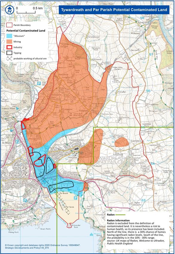
Appendix P Potential Contaminated Land and Radon .................................................... 70
Appendix Q Views of Civil War Battlefield 1644 Map and Photos .................................. 76
2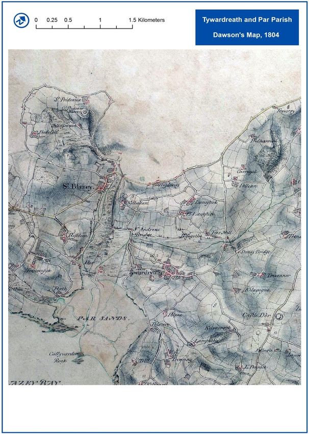
Notes:
   1. The NDP for Tywardreath and Par Parish, the associated Evidence Summary and
      the Basic Conditions Statement along with other documentation is to be found on
      the Tywardreath and Par Parish Council website in the NDP section:
      https://www.tywardreathandparparishcouncil.gov.uk/neighbourhoodplan.php
   2. This Appendix includes the Landscape Character Assessment and other
      documents which include contextual information for understanding the NDP.
   3. Maps in the main NDP can be viewed more easily using the zoom function on the
      Tywardreath and Par Parish Council website in the NDP section:
      https://www.tywardreathandparparishcouncil.gov.uk/neighbourhoodplanmaps.php
   4. Given the importance of Blue space within the parish e.g. the sea, river, wetlands,
      the term Blue Green (space) is used instead of Green Infrastructure.

                                                                                    3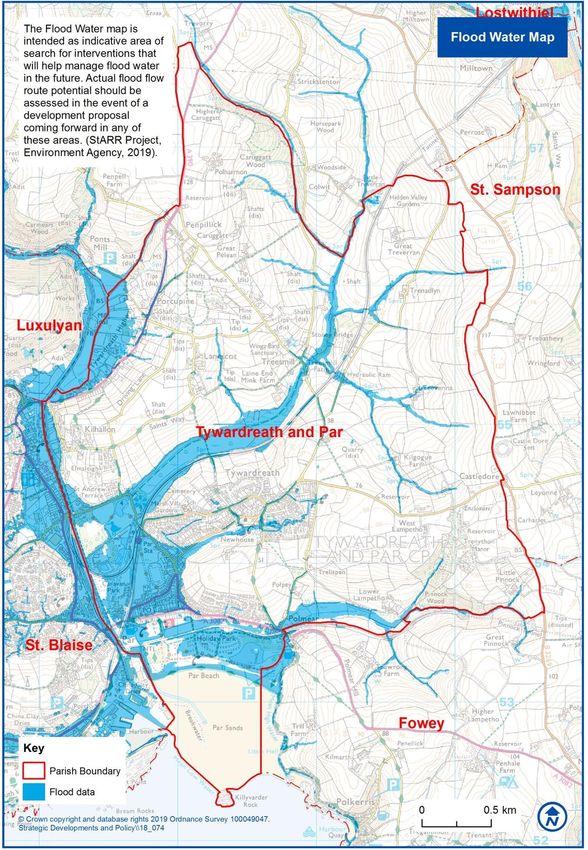
Appendix A: Landscape Character Assessment
Notes: All the maps referred to in this document are available on Tywardreath and Par
Parish website under Maps, NDP Section.
https://www.tywardreathandparparishcouncil.gov.uk/neighbourhoodplanmaps.php

Having consulted the Cornwall Isles of Scilly Landscape Character Assessment, it was
decided to include a more detailed local character assessment and land use survey as
supporting evidence for the policies developed.
Cornwall Isles of Scilly Landscape Character Assessment, CA39, (2007),
https://www.cornwall.gov.uk/environment-and-planning/cornwalls-landscape/landscape-
character-assessment-2007/

Section 1: Background
The parish1 is bounded to the west by the valley of the Par River and to the east by the
watershed of the Fowey River. Par Beach forms the western part of the southern
boundary, the eastern part being the valley of the Polmear stream. The northern boundary
is defined by the Caruggatt stream and the headwaters of the Treesmill stream. It rises
from close to sea level on the west to over 110 m on the east.

a) Geology and Geomorphology
The whole of the parish is underlain by the Devonian Meadfoot Beds, a thick sequence of
dark shales and siltstones with sporadic grey-brown sandstones and beds of decalcified
shell debris of Devonian age. This was subjected to significant faulting during the
emplacement of the Hensbarrow (St Austell) granite, predominantly north-south but with a
secondary east north east – west south west pattern. There was significant mineralisation
of these faults, mainly quartz and copper minerals, which gave rise to the important
historic mining area in the north-west of the parish.

Sea level changes in the Quaternary cut a series of terraces backed by degraded cliff
lines, the most significant being at approx. 110 m, 90 m and 50 m (there are further
terraces buried below the sediments of the Par River down to at least 20 m below present
sea level). The present drainage pattern probably developed during the various ice-ages
as water from melting ice and snow to the north cut down, preferentially along major fault-
lines to a sea-level well below the present. These valleys are characterised by “youthful”
profiles, with steep valley sides.

As sea levels rose at the end of the ice-age, the valley of the Par River flooded to become
a ria2, like the Fowey to the east, probably as far north as Ponts Mill, just west of the
northern boundary of the parish, and remained in this state well into historic times. Indeed,
it was not until the C16th that a bridge was built where the A390 crosses the river and
another across the Treesmill stream at St Andrew’s Road (to replace a “dangerous” tidal
ford); c.f. Par Estuary Map c.1500, Figure 1 on the following page.

1 c.f. Tywardreath and Par Parish Map, in NDP or in Maps, NP Section, Parish Council website,
https://www.tywardreathandparparishcouncil.gov.uk/neighbourhoodplanmaps.php
2 A ria is the lower part of a river valley which has been "drowned" due to sea-level change to form an often

sinuous estuary similar to those of the Fowey or Dart.
                                                                                                      4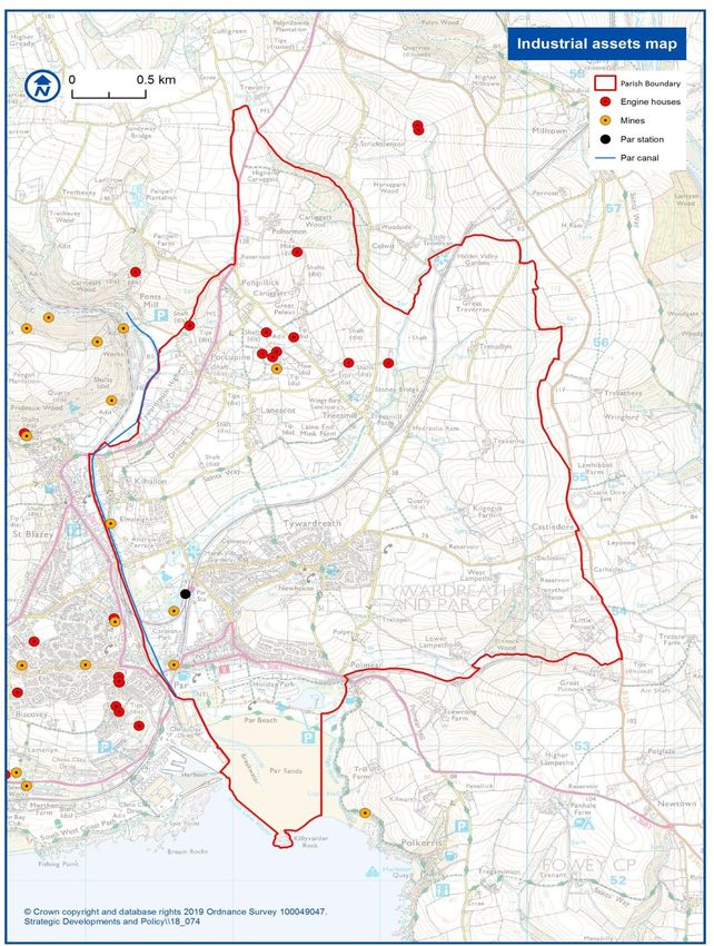
Figure 1, Par Estuary Map c.1500
http://www.luxulyanvalley.co.uk/Luxulyan_Valley_archaeological_survey_1988.pdf

                                                                                 5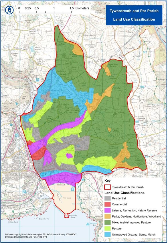
Downstream of this, the first bridge built was that of the Cornwall Railway in the mid C19th.
From the latter part of the C18th the ria started silting up, largely due to fine mineral waste
from metalliferous mining and subsequently from clay-working in its catchment. By the end
of the C19th the entire estuary north of the Par-Fowey branch-line (now a haul-road) was
infilled by salt-marsh.

The geology/geomorphology of the parish has had a profound effect on its landscape
character, affecting not only land-use but also communications and social development.
There is still a strong sense amongst residents of “difference” between those on the east
and west sides of the old Par River “estuary”.

b) Settlement & Communications
Settlement patterns closely reflect the landforms described above. The parish is
essentially rural in character with well over 90% of dwellings lying within 500m of the
historic limits of the ria. This applies to both C19th and post 1900 homes. The upland
areas have a dispersed settlement pattern with fewer than 60 homes spread over 90% of
the area. Most of the population live in Tywardreath village, located above one of the
“creeks” on the east bank of the ancient estuary or in Par, developed on the salt marsh
after the coming of the railway.

Communications routes are also controlled by the landscape. The present A390 runs NE-
SW along the northern boundary of the parish and represents the ancient highway
traversing the south of Cornwall and crossing the Par River at its then lowest bridging
point. Another ancient ridgeway (now the B3269) forms an eastern boundary, linking the
port of Fowey with the spinal road. A secondary old road originally linked Fowey, via tidal
fords at Polmear and Tywardreath with St Blazey (now re-routed via Par Green as the
A3082 to St Austell). The only other significant road, only gaining importance in the C19th
for transporting ore from Tywardreath to Fowey, runs E-W from Castledore through
Tywardreath to Par. The main railway line through Cornwall enters the parish through a
tunnel to run down the Treesmill Valley to Par Station. Here it links with the Newquay
branch line (originally a mineral line) and with the ex-Par-Fowey branch which follows the
Polmear Valley to Pinnock Tunnel (the route of this line is now used as a haul-road for
china-clay traffic to Fowey Docks).

Section 2: Landscape Character Assessment
a) Methodology
As part of the Neighbourhood Plan project a land use classification was carried out by
members of the Steering Group, some of whom have formal training in such surveys.

It was done on a field by field basis using aerial photographs and large-scale maps,
supported, where necessary, by field work during the autumn/winter of 2018. As
appropriate, local knowledge and questioning of landowners was done to clarify specific
problems.

Having reviewed the initial data, it was decided that the following categories would be the
most appropriate for defining the types of land use.

                                                                                       6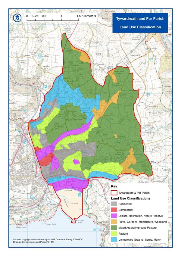
1.   Residential
   2.   Commercial
   3.   Leisure, Recreation, Nature Reserves
   4.   Parks, Gardens, Horticulture, Woodland
   5.   Mixed Arable/Improved Pasture
   6.   Pasture
   7.   Unimproved Grazing, Scrub, Marshland
Results were then plotted on a map of the parish which provides a graphic illustration of
the distribution of categories; c.f. Land Use Classification Map, Figure 2 on the following
page.

                                                                                      7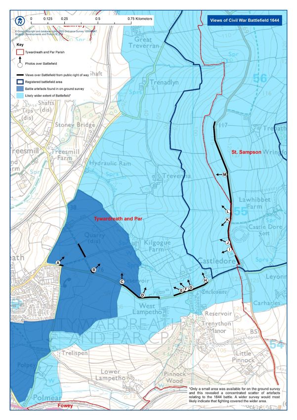
Figure 2, Land Use Classification Map

                                        8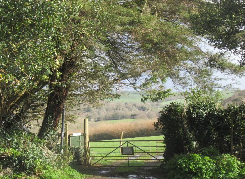
The Land Use Classification Map shows clear spatial relationships of the categories with
the landforms. Further information is available in the separate Land Use Classification
document in Appendix B. The object of this work was to provide a spatial structure for the
formulation of the specific policies contained in the plan. However, it also provides an
objective basis for a broad analysis of landscape character types.

b) Landscape Character Types
As indicated earlier, there are three broad Landscape Character types defined by the
geological history of the parish. Within these categories, it is possible to identify a number
of sub-groups which reflect historic socio-economic activity within them, in particular urban
development and mining.

i) Ancient Upland Terraces
Over 60% of the parish falls into this category, predominantly in the east. It is
characterised by wide, open expanses of actively farmed, well-drained agricultural land
with fairly good soil and moderate gradients, mainly devoted to fodder crops or potatoes
alternating with improved pasture. This supports important beef and dairy farming, with
virtually no land unused. Fields tend to be of 2 to 5 ha, often irregular in shape and still
bounded by Cornish hedges of stone topped with a variety of native shrubs and trees
including species such as hawthorn, hazel and holly and are generally in good state of
repair as shown on the Cornish Hedges Map.3 Historic evidence (e.g. tithe maps and
Dawson’s Map, 18044) suggest that most of these boundaries are at latest late-mediaeval
in age and there is only limited evidence of subsequent consolidation of fields. Generally,
they are of a shape and size to make them amenable to cultivation with modern
agricultural machinery.

The eastern part of this area comprises a registered Historic Battlefield Site (from the Civil
War) although strong archaeological evidence indicates that the battle (a Dunkirk-style
retreat) covered most of the ground from Castledore to Polmear; c.f. Designated Heritage
Assets Map and Civil War Battlefield 1644 Map.5

With limited exceptions, the only dwellings lying within this category are associated with
old farmsteads, although, with the consolidation of farms to modern economic units,
several of them are now purely residential properties.

Mining Area

In the NW of the parish a belt of land running roughly NW-SE from the A390 to the
Treesmill Valley and occupying some 39 ha represents the site of Fowey Consols Copper
Mine; c.f. Industrial Assets Map, Figure 17 in main NDP document and Appendices L, M
and P in this document.6 Most of the spoil tips and surface buildings have been removed,

3 Cornish Hedges Map, in main NDP and available in Maps, NP Section, Parish Council website,
https://www.tywardreathandparparishcouncil.gov.uk/neighbourhoodplanmaps.php
4 Dawson’s Map, 1804, see Figure 3 in this document and available in Maps, NP Section, Parish Council

website, https://www.tywardreathandparparishcouncil.gov.uk/neighbourhoodplanmaps.php
5 Designated Heritage Assets Map and Civil War Battlefield 1644 Map in main NDP and available in Maps,

NP Section, Parish Council website,
https://www.tywardreathandparparishcouncil.gov.uk/neighbourhoodplanmaps.php
6 Industrial Assets Map, Figure 17 in main NDP and available in Maps, NP Section, Parish Council website,

https://www.tywardreathandparparishcouncil.gov.uk/neighbourhoodplanmaps.php
                                                                                                  9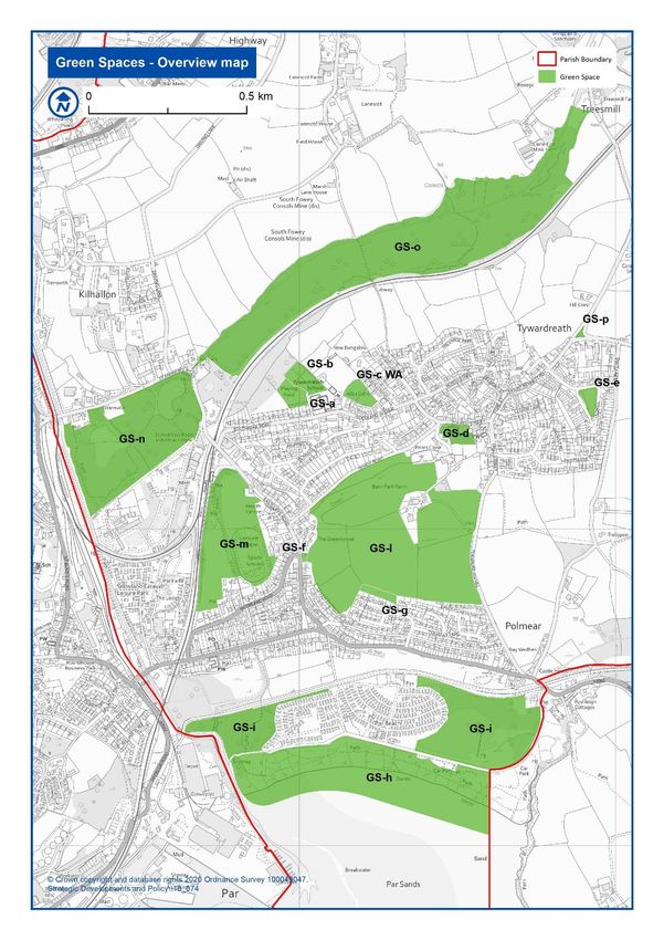
although the listed Austin’s Shaft engine house remains a prominent landmark, visible
from many vantage points.

Prior to mining, this area would have been similar in character to the surrounding upland.
However, the mining activity has left the ground impoverished and it is now largely rough
pasture with some scrubland. In the C20th there was some construction of isolated private
residences of various styles. These are largely screened by mature trees and the area
retains a rural character, albeit less “open” than its surroundings.

ii) Valley Slopes
As mentioned earlier, the valleys of the Par River and its eastern tributaries are
characterised by steep slopes. In the case of the eastern side of the main valley, these still
retain the form of a somewhat degraded cliff-line as far north as the level-crossing on the
A390 and are largely covered in trees and scrub vegetation. Upstream of this and in the
tributary valleys of Treesmill, Tywardreath and Polmear, gradients are less severe (15 – 40
degrees). Soils are thin and of poor quality; and this land is largely used for pasture,
although hay is cropped on the less steep parts. The upper part of the Polmear Valley is
covered in mature woodland, part of the grounds of Trenython House, once a stately home
and today a country-club/leisure complex.

These slopes make a significant contribution to the rural character of the parish. The
slopes north and south of Tywardreath village are of particular importance in defining clear
limits to the urban area and providing a strong buffer between the village and Par, which
make a major contribution to maintaining a strong sense of separation between the two
communities.

In the upper part of the Treesmill Valley, some 23 ha of land, naturally lying within this
category, have been dedicated to private parkland and gardens. These contain more
trees, breaking the broader character of the surrounding landscape but, partly because of
the tree cover, associated buildings are subservient in broader views.

Apart from their role in creating the distinctive landscape character of the parish, the
woodland and hedges along these slopes provide a “wildlife corridor”, offering a
remarkably high level of connectivity through the parish, both N-S and E-W. As such they
play a key role in maintaining its rich bio-diversity.

iii) Valley Floor
As indicated above, almost all the low-lying land on the western side of the parish
occupies the site of a ria (drowned valley) which was progressively infilled from N–S with
fine waste from mining upstream from the C18th onward. The pre C19th shoreline is
approximately defined by the current 5 m contour: this crosses the main Par valley by the
bridge on the A390, the Treesmill valley at Treesmill Farm, extends up the valley towards
Tywardreath village for approx. 110 m from the bottom of Tehidy Road and in the Polmear
valley crosses the valley some 1,000 m upstream, just below Lower Lampetho Farm. In
the C17th, salt was extracted in salt-pans in the lower part of the Treesmill valley. The old
cliff-line can still be clearly seen at many locations, from the A390 to Par Beach. As late as
the C19th, a ferry operated from the foot of Tehidy Road to Par.

                                                                                      10
Figure 3, Dawson's Map 1804
https://www.bl.uk/onlinegallery/onlineex/ordsurvdraw/f/0020sd000000005u00321000.html
11Dawson’s Map of 1804, the first properly surveyed map of the area, illustrates the situation
at the start of the C19th, before the mining boom really got under way and before the
coming of the railways. The shore-line can be seen running WNW from roughly Hamley’s
Corner, approximately on the line of Par Green with an inlet reaching NE to approximately
the lower part of Tehidy Road. It is interesting that the long straight ditch which still runs
across Par Track was already in existence, probably dug in the C18th to alleviate flooding
in the St Andrew’s Road area from the Treesmill Stream.
Historically, the progression would have been to tidal mud flats, then salt-marsh, then
grassland, which would have been grazed but subject to frequent flooding or colonised by
scrub and stunted trees such as willow. Given that the whole of this area lies within 5 m of
sea level, the water table is very shallow (< 1 m below surface at high water spring tide).
Substantial areas remain marshland to the present day, notably from Treesmill down to the
Par River and the lower parts of the Tywardreath and Polmear valleys.
Silting up of the estuary upstream accelerated in the mid-C19th with the building of the
embankment for the Cornwall Railway (now the main line), coinciding with the peak of the
copper mining activity on either side of the valley and again in the 1870s with the building
of the embankment for the Fowey-Par railway line. By 1900, almost all the present land
surface was “dry” land, although subject to frequent flooding. Most of it remains
categorised as Flood Zone 3.
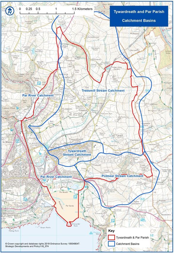
The Drains and Drainage document and Catchment Basins Map7 gives more detail on the
reasons for flooding which has resulted in EA interventions in this area. Tywardreath and
Par Parish is the focus of the multi-million StARR project which aims to reduce flood risk to
communities living and working in the St Austell Bay area, particularly in Par and St
Blazey. As part of this initiative, the EA drafted the Flood Risk Management policies in this
NDP and drew up the Flood Water Map8 on the following page. It is instructive to compare
the similarity of this map to the Par Estuary Map Circa 1500 shown above. With the
building of the Fowey-Par railway line embankment, the area to its south became the de
facto coastline and rapidly became a beach, predominantly formed from waste washed
down from china-clay workings, with development of a substantial dune system; currently
one of very few accreting dune systems in the country.
7
Catchment Basins Map in main NDP, Appendix C and available in Maps, NP Section, Parish Council
website, https://www.tywardreathandparparishcouncil.gov.uk/neighbourhoodplanmaps.php
8 Flood Water Map, in main NDP, Appendix C and available in Maps, NP Section, Parish Council website,
https://www.tywardreathandparparishcouncil.gov.uk/neighbourhoodplanmaps.php
12Figure 4, Flood Water Map
13Note: The CWLT Wildlife Resource Map, 2018 and associated guidance notes include
information on a range of topics including statutory and non-statutory designated sites, e.g.
County Wildlife Sites is particularly informative; c.f. Maps, NDP Section,
https://www.tywardreathandparparishcouncil.gov.uk/neighbourhoodplanmaps.php
Cornwall Council Interactive Mapping also has numerous map layers available including
county wildlife sites
https://map.cornwall.gov.uk/website/ccmap/?zoomlevel=5&xcoord=209015&ycoord=55084
&wsName=ccmap&layerName=Areas%20of%20Outstanding%20Natural%20Beauty:Coun
ty%20Wildlife%20Sites%20-%20no%20implied%20public%20access:Parishes
The landscape character of this area is closely related to its historical emergence. Four
broad categories can be identified.
Willow Carr
A broad swathe of willow carr runs E-SE from the Par River south of St Andrew’s Road,
almost to the bridge at Treesmill, averaging about some 300m in breadth and covering an
area of some 4.63 km2. Most of this area is permanently waterlogged and includes Par
Duck pond (Par Marsh Id R10, County Wildlife Sites, Cornwall Council Interactive
Mapping, 2019). There is an earth bank across the valley just east of St Andrew’s Road,
with a sluice-gate which can be shut to use the area upstream for flood retention. Almost
the whole of the area is covered by County Wildlife Sites and Local Nature reserves and it
supports a diverse range of wetland vegetation and associated birdlife, small mammals
and invertebrates. It is traversed along its length by a footpath on the bank of the Treesmill
stream and N-S from Tywardreath village to Lanescot by the Saints Way path, both well
used by walkers who enjoy its tranquillity and wildlife. However, most of it is inaccessible
and provides an undisturbed haven for that wildlife.
A second area of carr lies beside the river at the western end of Par Beach, stretching
inland to within 50 m of the W end of Par Green where it is linked by a “green corridor” on
either bank of the Par River to the area discussed above, providing a degree of bio-
connectivity between the two zones. This area has no public access other than a “nature
trail” through its SE corner. It serves an important visual and acoustic screen between Par
and the industrial activities on Par Docks.
East of the caravan site behind Par Beach is another area of carr covering some 6.5 ha,
including a large pond (Polmear Lake, Id R3.3, County Wildlife Sites, Cornwall Council
Interactive Mapping, 2019) which attracts large numbers of aquatic birds (including rare
migrants). Surrounded by areas of public access, it lacks the tranquillity of the previous
areas but is very popular with both locals and visitors. It is an important element of the
landscape in both near and distant views.
Immediately NE of this area, on the E side of the A3082, lies an area of marshland, with
limited tree growth, running up the Polmear Valley for some 400 m and covering 1.2 km2. It
lacks the diversity of vegetation of the other areas. However, it has no public access and
supports a significant fauna. From a landscape viewpoint, it provides a significant contrast
in “texture” with the arable and pasture land to the north and south. It also serves as an
effective barrier to ribbon development spreading any further east from Par.
14Rough Pasture
As the salt marshes drained in the latter part of the C19th, most of the “new” land (other
than the carrs discussed above) was used as rough pasture, with drainage leats being
dug. The most prominent of these runs south from Par Station to the Par River just before
it enters the sea.
Today, only fragments of this pasture remain, most having been subsumed by C20th
urbanisation. That which remains is largely now neglected or in only occasional use due to
its poor quality, fragmentary nature and the fact that it is frequently flooded and
waterlogged. Examples can be seen in the main Par Valley north of Tywardreath Highway
and north of St Andrew’s Road; in the Treesmill Valley just below the bridge at Bridge
Farm; in the lower part of the valley running up from Par to Tywardreath; in the area
between Par Green/Polmear Road and the haul-road and a small area in the Polmear
Valley just west of Lower Lampetho Farm.
This land tends to be waterlogged at times and liable to occasional flooding: it is all in
Flood Zone 3. It is of limited agricultural or commercial value. It does, however, have
significant landscape value, as it provides (with the carrs discussed above) a strong
“green” boundary to the western side of the settlement area and also a clear division
between the rural character of Tywardreath & Par Parish and the more urbanised area to
the west of the Par River. It is also a valuable component in the bio-connectivity of the
lowland areas of the west of the parish, helping maintain their diverse flora and fauna.
Urbanised Land
The older settlements of the parish were, of necessity, located on higher ground, mainly on
the western edge of the upland terraces. As the sea receded and flat, easily developed
land became available on the valley floor, much of this was progressively used for
residential and commercial purposes, encouraged in part by the development of the
railway and new roads. Initially (mid-late C19th), this took place on what had been old
beach-lines (Polmear, Eastcliffe Road, St Andrew’s Road, Tywardreath Highway) and
along the sand-spit running west from Hamley’s Corner (Par Green), spreading north-east
with the construction of Moorland Road in about 1900 and subsequent infilling along much
of the east side of the main valley. The character of this development reflects the history of
its development. As almost the whole area is in Flood Zone 3 and has historically been
subject to frequent flooding, this has been a significant factor in constraining the extent
and character of development. Almost all of the non-agricultural industrial activity in the
parish is concentrated in three small zones on the valley floor: north-east of the level
crossing on the A390, east of the level crossing at St Andrew’s Road, and between the
Newquay branch line and the Par Duck Pond in St Andrew’s Road Nature Reserve, (Par
Marsh Id R10, County Wildlife Sites, Cornwall Council Interactive Mapping, 2019); c.f. the
Employment Sites and Land Map9 . The businesses here are all light industries, housed in
low rise utilitarian buildings and have only minor, local, landscape impact.
9
Employment Sites and Land Map, in main NDP and available in Maps, NP Section, Parish Council website,
https://www.tywardreathandparparishcouncil.gov.uk/neighbourhoodplanmaps.php
15Figure 5, Green Spaces-Overview Map
16Leisure Use
Leisure uses occupy a substantial part of the valley floor area.
a) Par Running Track - shown as GS-m on the Green Spaces - Overview Map above.
This occupies a site bounded by Eastcliffe Road, Moorland Road and the main railway
line, covering some 7.5 ha. The land was owned by the Borough Council, which used parts
of the site as a shallow landfill site during construction of social housing in St Blazey in the
mid C20th. It was subsequently levelled and covered with top-soil and designated as a
public recreation area. Its amenities progressively improved to include one of two “tartan”
10 athletics tracks in the county as well as a modern, single-storey pavilion, two grass
soccer pitches and large areas of grass for informal recreational activity. In 2018 a 125-
year lease was granted to Par Track Ltd (PTL), a Community Benefit Society, in order to
secure its long-term future as public open space.
The Board of Directors has started on an ambitious programme to improve facilities and
encourage wider “fitness” usage in the local community. These proposals will have
minimal impact on the impact of the track on the local landscape.
From a landscape character point of view, the track forms a strong “green” physical buffer
between the communities of Par and Tywardreath, almost linking with the fields east of
Tehidy Road. Although most of its grassland is regularly mown and offers little in the way
of habitats for wildlife, its margins and the banks of the drainage leat which traverses the
site are largely hedges and rough grass with areas of natural shrubs and mature native
trees. These do offer a diverse habitat for invertebrates and small mammals, as well as
nesting/roosting sites for birds.
b) Par Beach (Par Beach, Polmear Lake and Par Sands, Id R3.3, County Wildlife Sites,
Cornwall Council Interactive Mapping, 2019) and shown as GS-h and GS-i on the Green
Spaces - Overview Map above.
Par Beach is locally considered as the whole area south of the haul-road (originally the
Par-Fowey branch line) as far as the high-water mark (HWM), from the Par River on the
west to the cliffs (and parish boundary) on the east. It is the newest landscape feature in
the Parish. In the 1880s the HWM was effectively the southern embankment of the railway
line; by 1908 there were some 50 m of beach before the HWM; by 1936 the HWM was
some175-250 m south of the railway, with salt-marsh extending to the southern edge of
the present pond; during WW2 a road was built along the back of the beach (the present
access road); by 1962 a belt of sand-dunes some 80 m wide and up to 10 m high
extended the width of the beach, south of the road, and had started to become densely
vegetated; today the dunes are over 150 m wide and still accreting. Below the HWM the
sandy seabed shelves very gently south. At low water spring tide it is possible to walk dry-
shod to Killyvarder Rock, 500 m off-shore.
There are five components to the leisure area of Par Beach, namely the two areas of carr
discussed above; the caravan site; the dunes; and the beach/foreshore. Together these
10 Tartan Track is a trademarked all-weather synthetic track surfacing made of polyurethane used
for track and field competitions, manufactured by 3M. It lets athletes compete in bad weather without serious
performance loss and improves their results over other surfaces.
17cover an area of almost 4 km2, with a beach frontage of some 850 m, between the haul-
road and the sea, largely accessible to the public.
Par Beach is an important natural, recreational and economic resource, not only to the
local community but also, given its proximity to good public transport (bus and rail within
1km on flat ground) and adequate car parking, to residents of much of Mid-Cornwall and to
holiday-makers. Its landscape characteristics clearly reflect this usage, although
commercial development is almost exclusively contained within the area of the caravan
site.
The current area occupied by the caravan site has been used for camping, touring and
“fixed” caravans since the 1950s. Whilst not enhancing the landscape it does provide an
important economic resource for the area. In terms of landscape impact, restricting the
size and scale of permanent buildings has helped minimise impact.
The dunes are almost unique in Britain for their continuing accretion. This provides a
sequence of habitats on which a progressively developing flora can be observed. This
includes several rare species, including some “red-listed” ones. There are some problems
with the proliferation of sea-buckthorn and rosa rugosa on the older parts. Although much
used by locals and visitors alike, the dunes also support a varied fauna of invertebrates,
amphibians, reptiles, birds and small mammals.
The dunes play an important part in the landscape both in local and broader views,
establishing a clear separation between the coastal scenery and the “built” landscape
behind.
The beach itself is a very significant feature in the landscape, with fairly flat sand extending
over some 4 ha at high tide, up to 47 ha at low water spring tide. It offers safe recreational
space for walking, dog-exercising, beach activities and shallow water recreation, being
widely used by local residents, those from a wide area of Mid-Cornwall and holiday-
makers.
Horses at Par Beach
18iv) Urban Landscape Character
The urban landscape of the parish is concentrated in three areas: Tywardreath, Par and
Tywardreath Highway, each of which has distinct characteristics reflecting their historical
development. Clearly there is considerable overlap in the descriptions below with those in
the “Land Use Classification” information and Land Use Classification Map in Appendix B
of the Tywardreath and Par Parish NDP.
a. Tywardreath
The village was already a significant settlement at the time of the Domesday Book and
centre of a Hundred in mediaeval times, with a priory established in the C12th. With the
dissolution of the monasteries it stagnated until the late C18th and the development of a
thriving copper-mining industry nearby, for which it became a residential and commercial
hub, its population doubling in less than 25 years. Over the next 75 years, most of the
buildings in the village were rebuilt, the ruins of the priory being used as a source of
construction materials so that there is nothing of its buildings to be seen today.
Construction then stagnated until the beginning of the C20th when, largely, detached villas
and bungalows started to be built on the roads out of the village. Since WW2 three
significant housing estates have been built on fields immediately adjacent to the core of
the settlement: Poldrea (1950s), Trenant (1960s), Trevance Park (1980s). Because of their
scale, build-rate and proximity to the village centre (all within 500 m), they have been
assimilated into the fabric/community of the village. There have also been a number of
small in-fill developments and rebuilding of existing structures.
The core of the village is dominated by the parish church with C15th tower and its
extensive churchyard (now “closed”) characterised by close-mown grass, “wild” grassland
and mature trees. Most of the residential properties are typical C19th terraced miners’
cottages, most opening directly onto the street or with minimal front gardens but often with
significant amenity space behind. As noted in the Conservation Area Assessment (see
Tywardreath Conservation Area Character Appraisal, Cornwall Council 2010 p3), many of
these properties have been “modernised” over the years (in a few cases rebuilt) which
detracts from their historical integrity, although it does mean that they do offer good quality
accommodation in the C21st. Few properties in the core of the village have off-road
parking, so almost continuous on-street parking has a negative impact on the street scene.
In the first half of the C20th, the village saw expansion westward towards the station,
between Southpark Road and Tehidy Road. Building styles were eclectic, ranging from
semi-detached houses and bungalows to substantial detached properties. Most offer
relatively spacious accommodation and are characterised by substantial private amenity
space with trees and established gardens, creating a sense of green space. A small
council estate at Glenview built between the wars follows these characteristics.
In the late ‘50s the council built an estate of some 50 properties, mainly semi-detached
houses with some short terraces at Poldrea, just east of the village core. These properties
all enjoy substantial private amenity space and are spaced around a large green area with
play equipment; c.f. Poldrea Play Area photo under E1 policy in main NDP. In the early
‘60s the Trenant/Penstrasse estate was built immediately south east of the village centre,
consisting of some 90 detached bungalows of varying sizes but with a common general
19appearance. Being set back between 10 and 20 m from the road with largely open-plan
well-tended front gardens, the houses give the area a sense of openness which is
enhanced by the setting in a bowl, surrounded on the east and south by agricultural land
which renders the development subservient in the broader landscape.
A few years later the Trevance estate was built immediately north of the core of the village.
Its 60 or so properties show a range of building styles, reflecting the chequered history of
its development with large detached bungalows, terraced bungalows semi-detached
houses and short terraces. However, most properties are set back over 10m from the
road, with open-plan front gardens and there is a general sense of spaciousness and
coherence.
Over the past 50 years there have been a number of small developments on plots within
the existing development zone: St Benedict’s Place, St Sampson’s Close, Vine Place,
Elderfield Close, Anjardyn Place, Priory Close, Swallowfield Close, Nursery Close and
along Eastcliffe Road opposite the surgery. These have all been modest in scale (up to 10
dwellings), mainly bungalows, with some family homes. In addition, there have been some
20 individual developments on “windfall” infill sites within the village, mainly of family
homes. Generally, building densities have been low (< 20 dwellings/hectare) with good
private amenity space and conservation of many ancient boundary hedges.
Overall, the village has maintained a compact, nucleated form with all properties within
700 m of the church at the centre, almost all accessible by well-lit dedicated footways.
Over 90% of homes are within 300m of a bus-stop and the furthest is only 1.5 km from the
main-line railway station. It retains a rural “village” character.
b. Par
In mediaeval times there was a stone quay on the west side of the Par River, running
north-north west from roughly the foot of The Mount: it had no direct road link to St Blazey
(this only happened in the mid C19th with the coming of the railway). It was known as Par
and was linked by a bridge to fish cellars on marshland roughly where Pearce’s Row now
stands. It was the boarding point for a ferry which plied to a site at the foot of Vicarage
Road in Tywardreath. There was also a fishing hamlet at Porth, close to the present
entrance to Par Docks, although there was no direct link between Par and Porth. By the
latter part of the C19th, the original quay at Par was no longer functioning and the name
Par was being used for the settlement growing up on the east side of the river.
Most of the land occupied today by the settlement of Par was, until the C19th, an estuary,
tidal mud-flats and salt-marsh, although silting up rapidly with residues from mining and,
later, clay-working, in the Par River catchment. The building of the embankments for the
main railway line and the Fowey branch line in the mid C19th led to a much faster rate of
silting up, such that by the late C19th the whole area was “dry land”. However, to this day,
most of Par lies in Flood Zone 3.
For the above reasons, with the exception of a few fishermen’s cottages at Polmear, near
Hamley’s Corner and Pearce’s Row, the oldest buildings in Par only date to the latter part
of the C19th. The original development was of terraced cottages on the north side of Par
Green, which follows the line of an old sand-spit. These were succeeded in the early
C20th by generally more substantial semi-detached villas on the south side of the road
20and by a mixture of housing at the foot of the East Cliff on what had been the beach and
on the land above the cliff at Upper Eastcliffe. From the start of the C20th to the end of
WW1, the south side of Moorland Road was developed, mainly with terraced and semi-
detached properties. Between the wars a few bungalows and semi-detached properties
were built at the eastern end of the north side of the road and in the latter half of the
century the remainder of this side of the road was developed with a range of styles of
houses and bungalows.
In the late C19th a terrace of cottages and a farmhouse were built between the railway and
the Par River west of Par Green. In the latter part of the C20th, land north of this has been
developed with “park-homes” as a mixture of residential and holiday accommodation
totalling some 150 homes.
Other than a few older cottages and some 15 early C20th terraced and other properties at
Polmear, there was no development in Par east of Hamley’s Corner until some 30
spacious detached and semi-detached “villas” and bungalows were built along the north
side of Polmear Rd between the wars. At the end of the C20th a linear development was
commenced at Polmear Parc, immediately north of this, totalling 101 dwellings, mainly
modest bungalows but including 10 small detached houses on the SE side of the
development. Although fairly neutral in design, the large open front gardens, wide verges
and irregular layout creates a sense of openness. In 2015 a development of one large
bungalow, nine detached houses and a block of six maisonettes was built on the NE edge
of this development. This is a very cramped site and the unconventional design and
location continues to be a source of controversy in the community, particularly on account
of its prominence in public views, especially from Par Beach.
In the late C20th two large detached houses and three bungalows were built at the
western end of Polmear Road, below the old cliff line. Also, two small estates were
constructed, 7 bungalows on an “infill” site off Eastcliffe Road and 4 large dormer
bungalows on the former Par Engineering site at the junction of Eastcliffe and Moorland
Roads. In addition, there have been half a dozen individual detached properties built on
“infill” sites in the area.
Whilst Par does not share the rural village character of Tywardreath, with the possible
exception of the developments behind Polmear Road, Par has largely avoided the
amorphous suburbanisation which has befallen many similar coastal locations in Cornwall.
The natural barrier of the Par River and the railway line form a clear, strong demarcation
from the “urban sprawl” to the west and gives it a clear sense of identity.
All public roads in Par have well-lit footways and are close to public transport. The majority
of properties in Par have off-road parking for at least one vehicle, although, for the older
properties, this is often at the expense of their front amenity areas (although most of them
have above average space to the rear). A corollary of this is a loss of on-street parking
spaces: this is a significant problem.
c. Tywardreath Highway
Tywardreath Highway is a ribbon development along the A390 east of the level crossing
on the Newquay branch line, extending approx. 1 km north east to Porcupine, at the foot of
Penpillick Hill, totalling some 90 dwellings.
21Development at Tywardreath Highway started in the C19th, associated with the Fowey
Consuls Mine immediately to the east (Porcupine gets its name from a pub of that name
which served the miners). Most of these buildings were typical modest terraces although
there are several larger properties which may have been farms originally. Most of these
properties have been modernised and extended over the years and are in generally good
state of repair.
From the mid C20th to the present day there has been in-fill development, almost entirely
individual dwellings, mainly on the southern side of the A390 but sites are restricted by the
steepness of the hillside. Dwellings are in a range of traditional styles, almost all detached,
ranging from modest bungalows to 3 / 4 bedroom houses. At the start of the C21st, a
development was started on the north-west side of the A390, Grove Park. At present there
are six large, individually designed houses in spacious gardens and there could be scope
for a few more near the junction with the A390, if EA concerns on flooding can be
addressed.
d. Kilhallon
Originally a mediaeval farm on the lane from Par to the bridge over the Par River at St
Blazey, there was some development in the C19th, probably associated with the nearby
mines, including two substantial properties, Torton and Elmsleigh, the latter now a care-
home. In the mid-part of the C20th an estate of 19, individually designed detached
properties of varying size, houses, dormer bungalows and bungalows, on a site of approx.
2 hectares was built at Kilhallon Woodlands. A little later, an area of approx. 0.7 hectares
was developed on the western corner of Driving Lane comprising 8 individually designed
substantial properties. In the past 50 years some 8 individual “infill” properties have been
built in Kilhallon.
e. Outlying Dwellings
There are only some 50 or so dwellings in the parish outside the areas discussed above.
Most are working farms or farmhouses which have become homes due to farm
amalgamation or they are related to on-site rural activities (equestrian, horticulture, bird
sanctuaries etc.) or are buildings associated with the past mining activity in the area; 20 or
so are private dwellings built in the latter part of the C20th. There is considerable diversity
in their size and character: however, most follow traditional styles of design and blend into
the rural landscape.
Section 3 Addendum
An important characteristic of the landscape of the parish as a whole is the degree of
“connectivity” between the undeveloped parts. Even where “green” areas are not
contiguous they are interconnected by stream and river banks, railway embankments and
substantial hedgerows, providing a corridor for wildlife; c.f. Blue Green Corridors Map on
the following page. Even in the urban areas the substantial mature garden areas and
hedgerows provide a haven for fauna and flora. This makes a significant contribution to the
rich biodiversity of the parish. It should be a material consideration when assessing any
proposed developments, especially in the western part of the parish, where such links are
particularly vulnerable.
22Appendix B: Land Use Classification
This document is accompanied by a Land Use Classification Map below.
A. Introduction
A clear understanding of current land utilisation and its distribution in the parish is
fundamental to recognition of the key characteristics which define its identity and to
underlie the policies to guide its future development.
Broadly speaking, the western/southwestern 21% of the parish lies on the flat reclaimed
marshland of what was originally the estuary of the Par River; 71%, to the east and north
of the parish, lies on upland terraces rising gently from a height of some 50 m to 125 m:
this area is dissected by a number of fairly steep-sided, flat-bottomed valleys orientated
roughly E-W to ENE-SSW, draining into the Par River catchment. Current land use is
largely guided by the physical constraints of these landforms and their historical
development. Future land use will also be constrained by the same factors.
B. Methodology
The land use classification was carried out by members of the Steering Group, some of
whom have formal training in such surveys.
It was done on a field by field basis using aerial photographs and large-scale maps,
supported, where necessary, by field work during the autumn/winter of 2018. As
appropriate, local knowledge and questioning of landowners was done to clarify specific
problems.
Having reviewed the initial data, it was decided that the following categories would be the
most appropriate for defining the types of land use.
1. Residential
2. Commercial
3. Leisure, Recreation, Nature Reserves
4. Parks, Gardens, Horticulture, Woodland
5. Mixed Arable/Improved Pasture
6. Pasture
7. Unimproved Grazing, Scrub, Marshland
Results were then plotted on a map of the parish to provide a graphic illustration of the
distribution of categories; c.f. Land Use Classification Map below.
This map shows clear spatial relationships of the categories with the landforms. It is
important to note that outside the areas identified as residential, there are only some 50
dwellings, of which the majority are working farms or residences linked to the use of the
site (e.g. horticulture, equestrian activity). Thus over 95% of the population live in less than
10% of the area of the parish. It is therefore reasonable to describe the land use of the
parish as predominantly agricultural.
23Figure 6, Land Use Classification Map
24C. Characteristics of Individual Categories
1. Residential
Residential areas comprise less than 10% of the parish and can be split into four clearly
defined areas with distinct characteristics.
a) Tywardreath
The core of the village is of mediaeval origin although most existing buildings date from the
late C18th or later. Most of the houses are terraced miners’ cottages with occasional larger
properties and are generally in good repair with considerable modernisation. In the early
C20th development took place on the margins of the village, particularly down Southpark
Road and Tehidy Road, mainly large detached or semi-detached properties, in a variety of
designs, with substantial gardens, giving these areas an open, green aspect.
Between the wars two small developments of “council houses”, semi-detached with ample
gardens, were built, at Glenview and Mount Bennett Terrace. In the 50s, a larger council
development of some 60 dwellings took place at Poldrea, on the SE edge of the village.
These are a mixture of semi-detached homes and short terraces, some divided into
maisonettes, with generous garden space, built around a large green space with an
equipped children’s play area.
Also in the 60s, development started at Trenant Road/Penstrasse Place on the southern
edge of the village, predominantly of detached bungalows on relatively spacious plots. A
few years later the Trevance Park estate was built on the northern edge of the village, a
mixture of detached bungalows on generous plots and smaller, semi-detached properties.
This development is characterised by wide green verges and grassed areas coupled to
open front gardens giving a very spacious feel to the site.
Over the past 50 years there have been a number of small developments on plots within
the existing development zone: St Benedict’s Place, St Sampson’s Close, Vine Place,
Elderfield Close, Anjardyn Place, Priory Close, Swallowfield Close, Nursery Close and
along Eastcliffe Rd opposite the surgery. These have all been modest in scale (up to 10
dwellings), mainly bungalows, with some family homes. In addition, there have been some
20 individual developments on “windfall” infill sites within the village, mainly of family
homes.
Overall, the housing stock of Tywardreath village has increased by some 300 properties
since the 1960s (approx. 20%), an average of some 5 per year. Because of the scale,
character and rate of development, the village has been able to assimilate this number
without losing its strong sense of identity and social cohesion. The community is well
linked by road (with regular bus services) and by rail (Par Station is less than 1km from the
centre of the village), and has a church, chapel, primary school, village hall, shop
(currently closed), butcher and two pubs. It shares a Health Centre with Par.
The village is contained within clearly defined development boundaries. It is important to
note that the communities of Tywardreath and Par, although contiguous at the foot of
Tehidy Road, have strong individual characteristics. The presence of the open farmland of
Tywardreath Hill, on the east side of Tehidy Road, is of crucial importance in maintaining
these identities.
25b) Par
Most of the land occupied today by the settlement of Par was, until the C19th, an estuary,
tidal mud-flats and salt-marsh, although silting up rapidly with residues from mining and,
later, clay-working, in the Par River catchment. The building of the embankments for the
main railway line and the Fowey branch line in the mid C19th led to a much faster rate of
silting up, such that by the late C19th the whole area was “dry land”. However, to this day,
most of Par lies in Flood Zone 3.
For the above reasons, with the exception of a few fishermen’s cottages at Polmear and
near Hamley’s Corner, the oldest buildings in Par only date to the latter part of the C19th.
The original development was of terraced cottages on the northern side of Par Green,
which follows the line of an old sand-spit.
These were succeeded in the early C20th by generally more substantial semi-detached
villas on the southern side of the road and by a mixture of housing at the foot of the East
Cliff on what had been the beach and on the land above the cliff at Upper Eastcliffe. From
the start of the C20th to the end of WW1, the south side of Moorland Road was developed,
mainly with terraced and semi-detached properties. Between the wars a few bungalows
and semi-detached properties were built at the eastern end of the north side of the road
and in the latter half of the century the remainder of this side of the road was developed
with a range of styles of houses and bungalows.
In the late C19th a terrace of cottages and a farmhouse were built between the railway and
the Par River west of Par Green. In the latter part of the C20th, land north of this has been
developed with “park-homes” as a mixture of residential and holiday accommodation
totalling some 150 homes.
Other than a few older cottages and some 15 early C20th terraced and other properties at
Polmear, there was no development in Par east of Hamley’s Corner until some 30
spacious detached and semi-detached “villas” and bungalows were built along the north
side of Polmear Road between the wars. At the end of the C20th a linear development
was commenced at Polmear Parc, immediately north of this, totalling 101 dwellings, mainly
modest bungalows but including 10 small detached houses on the south east side of the
development. Although fairly neutral in design, the large open front gardens, wide verges
and irregular layout creates a sense of openness. In 2015 a development of one large
bungalow, nine detached houses and a block of six maisonettes was built on the NE edge
of this development. This is a very cramped site and the unconventional design and
location continues to be a source of controversy in the community, particularly on account
of its prominence in public views, especially from Par Beach.
In the late C20th two large detached houses and three bungalows were built at the
western end of Polmear Rd, below the old cliff line. Also, two small estates were
constructed, 7 bungalows on an “infill” site off Eastcliffe Road and 4 large dormer
bungalows on the former Par Engineering site at the junction of Eastcliffe and Moorland
Roads. In addition, there have been half a dozen individual detached properties built on
“infill” sites in the area.
Par has good access by road (with regular bus service) and rail (Par Station). It has a
church, chapel, Scout Hall, pub, two convenience-stores and a bakery, plus Cornubia Hall,
26currently being developed as a community “arts hub”. There is a public library at Par
Track.
Further development in Par is very constrained by lack of suitable sites. Most of the readily
accessible land lies within Flood-Zone 3 and, with the effects of climate change, is likely to
become significantly more vulnerable even in the next 20 years. Apart from the importance
of the buffer of undeveloped land to the broader landscape setting of both Par and
Tywardreath, access would be problematic, significantly reducing the viability of providing
affordable homes.
c) Kilhallon
Originally a mediaeval farm on the lane from Par to the bridge over the Par River at St
Blazey, there was some development in the C19th, probably associated with the nearby
mines, including two substantial properties, Torton and Elmsleigh, the latter now a care-
home. In the mid part of the C20th an estate of 19 individually designed detached
properties of varying size, houses, dormer bungalows and bungalows, on a site of approx.
2 hectares was built at Kilhallon Woodlands. A little later, an area of approx. 0.7 hectares
was developed on the western corner of Driving Lane comprising 8 individually designed
substantial properties. In the past 50 years some 8 individual “infill” properties have been
built in Kilhallon.
Kilhallon cannot be considered a “sustainable” location for future development, although
there might be limited scope for further “infill”. The hamlet has no facilities within it (other
than Kittows butchers). It is over 500m, on unlit lanes with no footway, to the nearest bus
stop and the nearest shops are over 1km away, Tywardreath Primary school being 1.5km.
d) Tywardreath Highway
Tywardreath Highway is a ribbon development along the A390 east of the level crossing
on the Newquay branch line, extending approx. 1 km north-east to Porcupine, at the foot of
Penpillick Hill, totalling some 90 dwellings. Development is constrained to the south-east
by a steep slope, some 45 m high: to the north-west it is bounded by the flood-plain of the
Par River, much of which is in Flood-Zone 3. In the work being done by the Environment
Agency in connection with the StARR Project, most of this undeveloped land is designated
as “buffer” storage for flood-water. At the extreme west of the area there are a number of
properties between the lane leading to Kilhallon and the railway line. Since most of this
land is in Flood Zone 3 and the slope rises very steeply to the east there is very limited
potential for further development here.
Development at Tywardreath Highway started in the C19th, associated with the Fowey
Consuls Mine immediately to the east (Porcupine gets its name from a pub of that name
which served the miners). Most of these buildings were typical modest terraces although
there are several larger properties which may have been farms originally. Most of these
properties have been modernised and extended over the years and are in generally good
state of repair.
From the mid C20th to the present day there has been in-fill development, almost entirely
individual dwellings, mainly on the southern side of the A390 but sites are restricted by the
steepness of the hillside. Dwellings are in a range of traditional styles, almost all detached,
27You can also read