Bruce Trail - Mapping the Bruce Trail
←
→
Page content transcription
If your browser does not render page correctly, please read the page content below
I N S I D E :     V O L U N T E E R   AWA R D S    2 0 2 0

Bruce Trail
        VOL. 58, NO.1, WINTER 2020/2021

                                                       MAG A Z I NE

Mapping
the Bruce Trail
Our Mission
                       Preserving a ribbon
                       of wilderness, for
                       everyone, forever.
Photo: Kirstyn Smith
CONTENTS
            W INT ER 2020 / 2021

                                                                                       F E AT U R E S
                                                                                       6      Hiking Safely this Winter

                                                                                       7      Calendar Art – 2022
                                                                                              Call for submissions

                                                                                       7      Birthday Boots

                                                                                       12 Mapping the Bruce Trail

                                                                                       16 The Bruce Trail Reference - Through
                                                                                              the Years

                                                                                       20 Hiking Maps and How to Read
                                                                                              Them

                                                                                       21 Digital Maps or Paper Maps?
                                                                                       23 Mapping Indigenous Connections
                                                                                              to the Niagara Escarpment

                                                                       11              24 Volunteer Awards 2020

                 D E PA R T M E N T S
                 5 CEO’s Message
                 8 Land Acquisition Successes
                 11 Your Bruce Trail Story
                 28 Trail Changes
                 32 Our Donors
                 34 General Store

                 Bruce Trail Magazine is
                 available digitally.
                 To receive your Bruce Trail
                 Magazine by email:
                 • Fill out the request form at
                   brucetrail.org (News & Events
                   > Bruce Trail Magazine)          12
                 • Call 1-800-665-4453, or
                 • Email info@brucetrail.org to
                   make the switch
                                                   Cover photo: Bruce Trail at Dundas Valley by Ryan Mickeloff

W W W. B R U C E T R A I L . O R G                                                                               BRUCE TRAIL MAGAZINE   3
Bruce Trail                                          M AG AZIN E

               BRUCE TRAIL CONSERVANCY
      55 Head St., Unit 101, Dundas, ON L9H 3H8
      Toll-Free: 1-800-665-4453 Tel: 905-529-6821
    Email: info@brucetrail.org Website: brucetrail.org

                         Honorary President
                         Dr. Philip R. Gosling

                  Bruce Trail Founders
          Raymond Lowes, Dr. Philip R. Gosling,
         Dr. Norman Pearson, Dr. Robert McLaren

                      BOARD OF DIRECTORS
                        Leah Myers (Chair)
                          Cynthia Archer
                          Stephanie Bird
                           Heidi Bischof
                          Marlis Butcher
                          John Dickason
                          Michael Edney
                            David Hass
                          Brian Johnston
                         Corrie Kellestine
                           Linda Kerec
                            Bruce King
                          Jaclyn Moody
                         Nicholas Schulz
                          Lori Shalhoub
                        Wendy Thompson
                        Bonni Titgemeyer
                         Michael Treuman
                         John Whitworth

                                    STAFF
                  Executive Office
       Michael McDonald (Chief Executive Officer)
                   Allison Wright
                     Fund Development
                 Marsha Russell (Vice President)
                      Heather Anderson
                         Luisa Da Silva
                        Gloria Vidovich

             Communications and Engagement
               Elizabeth Harrington (Director)
                        Brooke Henry
                         Laura Tuohy
            Land Acquisition and Management
              Antoin Diamond (Vice President)
                      Joel Swagerman
                     Conservation and Trail
                    Adam Brylowski (Manager)
                         Scott Langley
                        Mara McHaffie
                         Brian Popelier
                              Finance
                        Kevin Durfy (Director)
                            Donna Miljic
                    Organizational Resources
                     Jackie Randle (Director)
                          Meghan Croll
                         Ryan Mickeloff
        Design and Production: Rossi Piedimonte Design Inc.
Bruce Trail Magazine is published quarterly by the Bruce Trail Conservancy (BTC).
Non-BTC related materials may not be the opinion of the BTC. Advertising herein
does not imply the endorsement of the BTC. Trademarks of the BTC published
herein are used with the permission of the BTC. No part of this publication may be
reproduced without written consent of the BTC. Canadian Publications Mail
Agreement #40040698. Return undeliverable copies to BTC, P.O. Box 857,
Hamilton, ON L8N 3N9. Charitable Registration # 11921 7578 RR0001.

4            BRUCE TRAIL MAGAZINE                                                    WINTER 2020/2021
Chief Executive Officer’s Message

                My Bruce Trail maps may          Guide. Our iconic guidebook has been             Through our maps and through our
                be a little dog-eared, but       the source of inspiration and information     Trail, we continually seek to connect peo-
                they fill me with joyful         for generations of hikers. In this issue of   ple to the Niagara Escarpment, and foster
                memories of hikes past,          Bruce Trail Magazine, we take a spin          a desire to preserve this ribbon of wilder-
                and excitement for the           through the history of the guidebook,         ness. Every year, our maps reveal more
                adventures to come. As the       peek behind the scenes with our Manager       and more land which has been preserved
New Year approaches, and I take time to          of GIS & Cartographic Services, Scott         by the Bruce Trail Conservancy, thanks to
reflect on this past year, it seems fitting to   Langley, and explore how mapping helps        our generous donors. The latest protected
be thinking about maps. Maps tell a story        so many aspects of our work at the BTC.       areas to be added to our growing conser-
and can show us both where we have                   We also explore cultural landscape        vation corridor are highlighted on page 8.
been and where we are headed.                    mapping and the steps the BTC is taking          Inspiring adventure, reflecting history,
    2020 certainly has a story to tell and       to recognize the long standing and ongo-      and connecting us to place, maps serve as
its map reveals quite a route. Our collec-       ing connections of Indigenous people to       a compelling reminder of the past, and
tive journey through 2020 has been filled        the Niagara Escarpment. Bruce Trail           can open us to new experiences ahead. I
with challenges, but also accomplish-            Conservancy and Plenty Canada worked          look forward to welcoming 2021 and tak-
ments and progress. (For a glimpse at            together to integrate Indigenous content      ing the next steps with all of you. •
some of those accomplishments, I invite          into the latest edition of the Bruce Trail
you to read about our 2020 Volunteer &           Reference. This marked an important step      Michael McDonald,
Trail Awards on pages 24-27).                    in our journey to honor Indigenous voic-      CHIEF EXECUTIVE OFFICER
    Recently, we released Edition 30 of The      es, and incorporate Indigenous land-based
Bruce Trail Reference, Maps and Trail            knowledge and experience in our work.
 Photo: Michael McDonald

W W W. B R U C E T R A I L . O R G                                                                         BRUCE TRAIL MAGAZINE          5
HIKING SAFELY THIS WINTER

                                                                                                                                           Photo: Michael McDonald
Hiking the Bruce Trail in the
winter can be a beautiful way to
explore the Niagara Escarpment,
stay active, and find solace in the
colder months.

Winter hiking normally involves a bit of
extra planning. This year, with COVID-19
concerns, this is especially true. Here are a
few important ways you can stay safe
while hiking this winter.

Stay local
• Avoid travelling outside your
  municipality or region.

Stay home if you are unwell
• If you are experiencing COVID-19
                                                • Avoid wearing cotton since it holds       Organized Group Hikes with our
  symptoms, stay home.
                                                  moisture. Opt for synthetics or wool.     Bruce Trail Clubs
                                                  This goes for socks too.                  Bruce Trail Club organized hikes are
Check for Trail Closures or
                                                • Keep your footing with strudy             currently open for BTC members and
Restrictions
                                                  waterproof boots, icers (removable        guests only. Registration is required.
• Check for Trail closures or restrictions
                                                  traction devices for footwear) & poles.   Group size is limited to 10 and wearing
  at brucetrail.org/trail-changes and the
                                                • Pack a flashlight or headlamp, with       masks on hikes is strongly recommended.
  websites of parks and other public
                                                  fresh batteries.                            The following Bruce Trail Clubs have
  landowners.
                                                • Fuel your body and stay hydrated.         paused their hiking programs until
Plan for earlier, shorter days &                                                            further notice: Toronto Bruce Trail Club,
changeable weather                              Practice Physical Distancing                Caledon Hills Bruce Trail Club, Blue
                                                • Avoid hiking alone in the winter, for     Mountains Bruce Trail Club, and Beaver
• Check weather conditions before
                                                  safety.                                   Valley Bruce Trail Club.
  heading out and be prepared for them
                                                • Keep 6 feet (2 m) apart from anyone         See the Hike Schedule and Group Hike
  to change.
                                                  not in your household.                    Guidelines at hikes.brucetrail.org
• Choose a route that is familiar to you.
                                                • Move aside to allow others to pass.
  When trails are covered in snow, it
  can be harder to find your way. Be
  extra attentive in looking for trail
                                                Expect No Facilities                        Please Note: These guidelines are in place
                                                • Do not expect public washrooms or         at time of printing (December 2020) and
  blazes.
                                                  indoor spaces to be open.                 may change in response to the evolving
• Choose a shorter distance than you
  would normally cover in summer                                                            COVID-19 pandemic and guidance
  conditions. Snow and ice will slow
                                                Leave No Trace                              provided by Canada’s and Ontario’s
                                                • Pack out everything you bring on          public health officers. Visit brucetrail.org
  your hiking speed.
                                                  your hike - including disposable face     for updates.
• Nightfall arrives earlier in winter
                                                  masks, food waste, and dog
  months. Start early in the day and
                                                  droppings.
  plan to be off the trail before dark.

Pack for the winter                               Remember: the Bruce Trail is not maintained in the winter
• Wear layers and pack extra layers.              Trail conditions vary according to season and the weather. The Bruce Trail is not
  Staying dry is key to staying warm in           maintained during the winter months. Hazards exist along the Bruce Trail. You
  the winter and layers will help you do          are responsible for your own safety.
  both.

6     BRUCE TRAIL MAGAZINE                                                                                          WINTER 2020/2021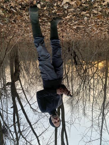
Seeking Art for 2022 Bruce Trail Calendar
Help us show off the beauty of              Trail Conservancy: Preserving a ribbon
                                            of wilderness, for everyone, forever.
the Bruce Trail and the Niagara
Escarpment to raise money to                Subject matter: must be along the Bruce
support our mission.                        Trail or related to the Niagara Escarpment
                                            – scenery, flora, fauna, historic sites, etc.
We invite you to provide a colourful
image of your explorations on the           Size: HORIZONTAL FORMAT no smaller
Bruce Trail and the Niagara Escarpment,     than 7 ½” x 10 ½” as this is the finished
showcasing its natural beauty, heritage     size of the calendar. Originals can be
and the people who hike it. We prefer       larger but must be in a horizontal format.
original artwork, so please no prints,
photographs or photocopies. High reso-      Medium: any medium may be submitted,            Deadline Friday, March 19, 2021
lution digital submissions are accept-      except prints, photographs and                  All artwork is to be received at the
able if original is too large to ship or    photocopies. Please consider reproduction       Bruce Trail Conservancy office by
deliver in person.                          quality when selecting the medium.              4:30 pm to be considered.
  A panel of judges will choose 13                                                          Physical/courier address: 55 Head St,
pieces for inclusion in the 2022            Information required to be printed or           Suite 101, Dundas, ON L9H 3H8
Calendar. All artwork remains the           attached clearly on the back:                   Canada Post address: PO Box 857,
property of the artist and will be          • your name, address & phone number             Hamilton, ON L8N 3N9
returned as soon as possible. Each          • medium used
artist who enters will receive a compli-    • title of the piece of work                    For more information: contact
mentary copy of the 2022 calendar.          • location along the Bruce Trail                Allison Wright at awright@brucetrail.org
  All profits from the sale of the calen-   If dating work on the front, please omit        or 1-800-665-4453 ext. 227.
dar go toward the mission of the Bruce      the month.

Birthday Boots
A delightful tale of a young family’s       and to protect our natural
                                            world. Cindi proposed the
first hike on the Bruce Trail. Twin
                                            story, Dr. Gosling connected
siblings, Molly and Max, learn about

                                                                                                                                           Photo: Margaret Northfield
                                            Cindi with Barry Scutt, who
the trail’s origin, and then discover the   provided the illustrations, and
                                            Birthday Boots was born.
many reasons that people of all ages,
                                               The Gosling Foundation
cultures, and activity levels enjoy         supported the production of
exploring this “Ribbon of Wilderness.”      Birthday Boots and has donat-
                                            ed copies to each of the 9 Bruce Trail          Available from the author, Cindi Conlon
– From the back cover of Birthday Boots
                                            Clubs to distribute. The Niagara and            $10.00 & shipping. Payment by Interac
                                            Iroquoia Bruce Trail Clubs, for example,        e-transfer. Contact Cindi at
Birthday Boots, is a new book for young     are offering Birthday Boots as a special gift   cindic@gto.net or 519-821-7376.
readers by Guelph author Cindi Conlon.      to all youth hikers who earn one of the
It grew out of conversations between        youth badges from the Clubs. Other              All proceeds from the sale of Birthday
Cindi and fellow Guelph resident, BTC       Clubs have shared copies with their local       Boots will be donated to the Bruce Trail
Honorary President Dr. Philip Gosling.      libraries and schools.                          Conservancy. •
Dr. Gosling shared with Cindi stories of       To share this charming Bruce Trail
the Trail, and indicated his desire to      story with the young readers in your life,
inspire the next generation to explore      contact Cindi to purchase a copy.

W W W. B R U C E T R A I L . O R G                                                                      BRUCE TRAIL MAGAZINE           7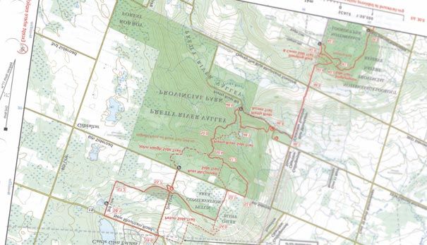
Land Acquisition Successes
The Bruce Trail Conservancy established three

                                                                                                                                                        Photo: Ron Savage
new protected natural areas between June and
October this year. Two of these represent
significant conservation successes, preserving
key Niagara Escarpment habitats and features,
and one reveals the importance that a small
property can have in enhancing and protecting
the Trail experience.

Tumbled Rocks Nature Reserve – Sydenham section
Kemble, Map 34, near km 147.6*
7.2 acres
542 m of trail secured
This small but geologically rich Nature Reserve preserves 7.2
acres of Escarpment slope and forest between Kemble
Mountain Management Area and the BTC’s Johnston proper-
                                                                                                Colpoy’s Cavern Nature Reserve – Sydenham section
ty, east of the Concession 24 and Kemble Rock Road. At the
north end is a karst feature where a stream falls into a sink-
hole and disappears. Further south, the Escarpment has bro-                     Colpoy’s Cavern Nature Reserve – Sydenham section
ken away from its edge and creates two cliff faces. A group of                  Wiarton, Map 35, near km 166.6
large, moss covered blocks at the south end, which long ago                     75 acres preserved
tumbled down the Escarpment, give this nature reserve its                       265 m of trail secured
name. The establishment of Tumbled Rocks Nature Reserve                         Colpoy’s Cavern Nature Reserve makes a beautiful addition
secures 542 m of the Bruce Trail’s Optimum Route, complet-                      to the Bruce Trail’s conservation corridor. Just east of
ing a stretch of 4.5 km of secured Trail from Kemble                            Wiarton, the 75-acre forested property is nestled between
Mountain Management Area to Dodd’s Hill.                                        Bruce’s Caves Conservation Area and Skinner’s Bluff
                                                                                Management Area, completing a missing link and creating an
                                                                                uninterrupted forested area along the Niagara Escarpment.
                                                            Photo: Ron Savage

                                                                                The large tract of mature forest, unlogged for decades, will
                                                                                support a robust woodland ecosystem and play a critical role
                                                                                in mitigating climate change.
                                                                                A cavern is tucked into the Escarpment edge at the north end
                                                                                of the property. This unique feature will be protected in per-
                                                                                petuity as part of this BTC nature reserve.
                                                                                With the establishment of Colpoy’s Cavern Nature Reserve a
                                                                                continuous 9 km stretch of the Bruce Trail’s Optimum Route
                                                                                is now secured from Colpoy’s Range Road to Bruce’s Caves.

                                                                                Shelton – Sydenham section
                                                                                Kemble, Map 34, near km 151.3
                                                                                2 acres preserved
                                                                                532 m of trail secured
                                                                                Thanks to generous donation of land from the Shelton fami-
                                                                                ly, a 532 m section of the current Bruce Trail route at
                                                                                Concession 24 and Big Bay Sideroad has now been protected
                                                                                within a small wooded corridor. Although it is not on the
                                                                                Bruce Trail’s Optimum Route, this acquisition secures the cur-
                                                                                rent route of the main Trail, keeping it off nearby roads.

                                                                                *All map numbers and kilometre references refer to those found in The
                                                                                Bruce Trail Reference Maps and Trail Guide, Edition 30.
Tumbled Rocks Nature Reserve – Sydenham section

8     BRUCE TRAIL MAGAZINE                                                                                                          WINTER 2020/2021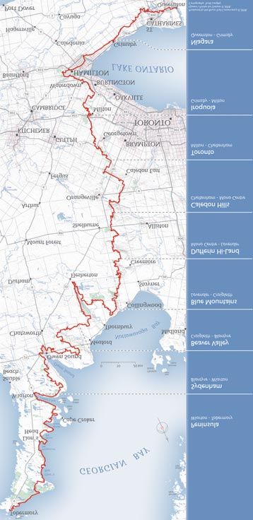
Two New Conservation
                 OPPORTUNITIES
Connecting people to nature and
preserving critical natural areas has never
been so relevant, or so important.

Today we have an opportunity to preserve an
additional 275 acres of Niagara Escarpment land
and secure more of the Bruce Trail’s Optimum
Route. But we can’t do it without you!

Help us act now to preserve:

Pine River Nature Reserve
192 acres, 510 m of Bruce Trail Optimum Route

The steep forested valleys and thriving wetlands of the Pine
                                                                                             e
                                                                     Pine River Nature Reserv
River Nature Reserve are a joy to explore and support a vibrant
ecosystem. Mature forests of Sugar Maple, Eastern Hemlock
and American Beech provide shelter for species of special
concern like the Eastern Wood Peewee. And coursing
waterways and precious wetlands are home to Bullfrogs,
Snapping Turtle and Mink.
   Past land use has damaged some of this property’s habitats.
Our experienced ecologists and volunteers are planning
extensive restoration projects to return these habitats to a
healthier state.

Honeywood Ridge
82.8 acres, 455 m of Bruce Trail Optimum Route

Picturesque and pastoral, this property’s open fields rise to the
west where wide vistas can be enjoyed from the Trail. The
meadows of Honeywood Ridge are dominated by grasses,
sedges and non-woody plants that provide important habitat
for species year-round. Preserving this property will ensure that
                                                                    Pasture on Ho
                                                                                 neywood Ridge
the Bruce Trail remains on this route, off the nearby Prince of
Wales Road.

                                                      continued >

W W W. B R U C E T R A I L . O R G                                                               BRUCE TRAIL MAGAZINE   9
We invite you to learn more
    about these properties at
    brucetrail.org

    The costs to bring Pine River Nature Reserve and
    Honeywood Ridge into our conservation corridor,
    steward them into the future, and support our
    mission-based programs, is more than $2.4
    million. Several generous donors have already
    contributed an inspiring $1.4 million.

    Your thoughtful donation can help us raise the
    remaining $1 million needed to ensure these
    lands are preserved and cared for forever.

    Donate today at brucetrail.org
    Or by phone at 1-800-665-4453 or by mailing the form below to
    Bruce Trail Conservancy, PO Box 857, Hamilton, ON L8N 3N9

✁

    Yes, I want to preserve Pine River Nature Reserve & Honeywood Ridge.
    Enclosed is my: ❍ Monthly Gift:                         $ _______________ / month

                             ❍ Single Gift:                 ❍ $250                ❍ $100                  ❍ $50                    ❍ $ _______________ other

    Payment by:              ❍ Cheque (payable to The Bruce Trail Conservancy or marked “Void” if setting up a monthly donation)           ❍ Mastercard             ❍ Visa

    Card #: _____________________________________________ Expiry Date: _____________ Signature: _____________________________________________________

    Name:_______________________________________________ Member# _________________________ Email: ________________________________________________
                                                                                                                          Your email is confidential and will not be shared with 3rd parties.

    ❍ I am interested in learning more about making a gift to Bruce Trail Conservancy in my will.
    ❍ I have included the Bruce Trail Conservancy in my will.
    If donations to the profiled properties exceed the required funds, or the BTC is not able to secure the profiled properties, your donation will be used to secure and
    steward other lands within the Bruce Trail’s conservation corridor.

    10      BRUCE TRAIL MAGAZINE                                                                                                                                      WINTER 2020/2021
Your Bruce Trail Story - Stories from our community
The Start
of a New
Journey
By Nicole Klassen
In June of 2011, my husband and I took a
trip to beautiful Tobermory for our 2nd
wedding anniversary.
It was a time of sorrow for us as we had just lost our first
pregnancy three weeks before our trip. Tobermory was the
perfect place to hike, explore and heal. After our trip we
talked of a dream to hike the whole Bruce Trail. Then in
March 2012 our first born came into the world, our son
Joel. Then our daughter Marie in April 2014, and another
son William in October 2015. Our thoughts of conquering
the Bruce Trail were forgotten amongst long nights, feedings
and Baby Shark.
My husband has an incredible love for trails and the for-
est. So naturally we are out hiking alot as a family. Our chil-
Photo: Nicole Klassen
dren are now 8, 6 and 4 and in January of this crazy and
strange year of 2020, we went on a hike through Woodend
Park in Niagara-on-the-Lake. On this hike my husband told
our kids about the Bruce Trail that we were hiking on. They
were so fascinated and having such a great time that they
didn’t want our hike to end and wanted to see more of the
Bruce Trail. My husband and I remembered our long ago Submit your Bruce Trail Story
dream of hiking the whole trail. So as a family we decided
to embark on that journey together. It may take us 10 years, Our Bruce Trail community abounds with stories.
15 or 20. We have completed 9 hikes (30+ km) since We want to hear yours.
January, starting at the Southern Terminus and Queenston
Submit your story to us at any time online or by
Heights. We live in Niagara and are so excited for our jour-
email and you may see it featured in an upcoming
ney to Tobermory. See you on the trails! • issue of Bruce Trail Magazine. Details at
brucetrail.org/pages/your-bruce-trail-story or contact
communications@brucetrail.org
W W W. B R U C E T R A I L . O R G BRUCE TRAIL MAGAZINE 11Photo:
MAPPING
THE BRUCE TRAIL
It is hard to imagine the Bruce Trail without a map.
We would all be lost in more ways than one.
Not only do maps help us find our Ever since a continuous footpath along land, and encourage the exploration and
way, they help us make sense of the the Niagara Escarpment was conceived protection of the Niagara Escarpment.
world and our relationship to it. They over 50 year ago, maps have been key. In the pages ahead we explore these
help us make decisions, visualize com- Now they are ever important in our themes and a few of the many ways
plex data, and even store memories and work to maintain over 1,300 km of maps play a role in our lives and in the
tell stories. trails, care for over 12,000 acres of pro- work of the Bruce Trail Conservancy.
In the work of the Bruce Trail tected land, work with hundreds of pri- Perhaps you will see your next map in a
Conservancy, maps play a central role. vate and public landowners, purchase new light.
To understand more about the art and science of mapping the Bruce
Trail, we sat down with the Bruce Trail Conservancy’s Manager of GIS &
Cartographic Services, Scott Langley. One of the longest serving
members of the BTC staff, Scott has been making maps, building and
navigation, map-reading skills and
managing a GIS database, and so much more for the BTC for 17 years. appreciation for cartography were all
Here’s a summary of that conversation. unleashed. I was not only obsessed with
backcountry exploration, but with the
How did you get started in cartography? Later in life, I was drawn to research, planning and analysis of
I think my love of cartography started at backcountry canoe tripping, and my mapping that went with it. I loved
a very young age with a love of love of maps was born. Canoe tripping investigating features on the map,
exploration. I grew up exploring the introduced me to three classic high- visualizing what those features might
large fields and forest behind my quality pieces of cartography I remember look like in reality. I built a great respect
parents’ house, building forts, catching to this day: the enormous Canoe Routes for those who created such maps.
snakes and playing around creeks. I of Algonquin Provincial Park map, and I started my working life as a screen
knew where everything was by way of the Frost Centre Area and Mississagi Area printer, in both industrial and textile
spatial memory and visual recognition; maps by Chrismar. printing. Working with graphic design
the perceived map in my mind. Through canoe tripping, my software and managing major projects
12 BRUCE TRAIL MAGAZINE WINTER 2020/2021were challenges I really enjoyed – and display medium. It’s important to know There, the map features are assembled,
would serve me well later – but I knew I if the map will remain in the digital layered and to a certain extent, stylized.
wanted to pursue something more closely realm, be professionally printed on Depending on the project, more research
aligned with the environmental sector. paper or a sign, or become a static web- or data acquisition may be needed at
I enrolled at Sir Sanford Fleming, based map. this point.
School of Environmental and Natural It’s even important to me to know Once the scale has been defined and
Resource Sciences, in Lindsay. In my what kind of paper a physical map will the general layout is complete, I export
second semester I chose a focus in be printed on. Uncoated paper absorbs maps destined for print production or
Cartography – a fitting way, I thought, ink differently than coated paper. other high quality uses to Adobe
to combine my design skills from my Newsprint only offers a very coarse Illustrator, a design program used for
previous career with my early passions resolution. I would tackle a map for editing vector graphics. Illustrator allows
fueled by adventure. newsprint completely differently than a me to further enhance a map in ways
map for a magazine. not available in the GIS.
What is the best part of your job? Next, I decide on a suitable map scale This is where the map really starts
One of the aspects that I value most is based on the proposed page dimensions coming together. I find it’s not only
the variety inherent in my role at the of the map, or otherwise choose the about what to include in the map, but
BTC. On any given day, I could be page dimensions based on the desired what to leave out – eliminating
working on a project for Trail map scale. I frame the map content unnecessary detail for the sake of clarity.
Development and Maintenance, Land while leaving room for surrounding map Defining a clear visual hierarchy, placing
Acquisition, Land Stewardship, elements (legend, scale bar, north arrow, the annotation, and adjusting
Landowner Relations, Fundraising, source credits). typography all happen at this stage.
Communications, or even our Bruce I begin creating the map in a Creating custom symbology, and
Trail Store. Geographic Information System (GIS). adjusting colour and line-weights can all
I also appreciate contributing to the
‘greater good’. I work for a spectacular
organization that is creating an
impressive conservation corridor for
people to enjoy via the Bruce Trail.
And, I have enjoyed working with
hundreds of volunteers over the years.
The organized network and authentic
dedication of volunteers in the BTC
never ever ceases to amaze me. We truly
wouldn’t be able to do what we do
without our volunteers.
How do volunteers play a role in mapping
the Bruce Trail?
To manage and accurately represent
such a wide geographic area, BTC staff
continuously rely on the skills and
contributions of our volunteers.
Volunteers help keep our data up-to-date
and ground-truthed. Using GPS
technology, volunteers geo-locate
features relating to a potential property
purchase, find and mark property
boundaries, report the coordinates of
newly installed structures, and of course
GPS new trail sections and reroutes. Like
in so many aspects of the BTC’s work,
it’s our network of volunteers that
enable us to accomplish so much.
How do you approach making a map?
Photo: Gloria Damaris Gutierrez
Since every map is a communication
tool, I start by identifying the purpose,
the primary message to be
communicated, the audience or user,
and how the map will be consumed.
Photo:
Next steps will depend on the final
W W W. B R U C E T R A I L . O R G BRUCE TRAIL MAGAZINE 13make the map come alive.
In the end, I need to take a degree of
artistic license, choosing where to land
on the scales of generalization versus
detail, exaggeration versus reality, and
feature placement versus locational
accuracy. For example, if the road
thickness was drawn to the exact scale,
you might not be able to see the roads
on the map or they might be mistaken
for thin streams. It’s rewarding to find
the visual appearance that best
communicates the message of the map.
How does it feel to be a cartographer in
the age of Google Maps?
With everyone having instant access to
online mapping, I see the principles of
cartography being just as relevant as
ever. It’s still important to find the best Ontario Base Maps. Property boundaries GIS is extremely powerful and is
ways to clearly convey the intended were hand drawn on these maps. Each absolutely vital in our line of work to help
message to the map user. property had a unique ID that was found us make logical and educated decisions
Online maps can be great tools for in a Microsoft Access database which based on the information available.
users and cartographers. Unlike static reflected the attributes of each property. In our Land Acquisition and
maps, online services like Google Maps Before I joined the staff, the Landowner Relations work, we use GIS
enable users to zoom in and out and production of The Bruce Trail Reference mapping and analysis extensively. It
have map features appear/disappear was outsourced. When I was hired in enables us to assess potential
based on an assigned display scale. It’s a November 2003, one of my first tasks acquisitions, create and apply for land
wonderful service. Updating, was to create Edition 23 of The Bruce severances, and understand land
maintaining and preserving balance Trail Reference for a spring release. ownership distribution.
within that kind of global system takes a Without a functioning GIS, I produced In our Land Stewardship work, we use
lot of organized effort. my first Bruce Trail Reference using the the information collected by BTC
Google Street View has actually helped graphic design based eps files from the ecologists and volunteers to create
me in my cartographic work. I have used previous edition. But I knew that a specialized maps for each of our BTC-
it to assess numerous situations on the better solution was needed. managed properties. Maps revealing
ground without having to leave my I set to building an operational GIS for vegetation and soil communities,
desk, like confirming the official label on the BTC from scratch. I started by cultural conditions, rare or invasive
a street name sign. And Google Street gradually capturing trail via GPS species and special land designations all
View Timeline has been invaluable in a technology (with the help of volunteers) help in the creation of ecological
couple of situations. to replace the digitized hand drawn management plans of our properties,
I am somewhat old school and believe estimates and lower resolution GPS data and track the progress of those plans.
that there’s still a place for paper maps that we had available. I produced In Trail Development & Maintenance,
in our world. Personally, paper maps are various datasets, went about sourcing all GIS plays innumerable functions, from
my only navigational companion, the additional essential geographic data, trail change implementation, to the
coupled with a compass, when going and created the necessary architecture. It management of data on all our Trail
into the backcountry. Even when hiking was a lot of upfront work, but other structures (bridges, stiles, boardwalks etc.).
the Bruce Trail, I continue to use the than software upgrades and Based on the attribute information
paper Bruce Trail Reference maps. For developmental improvements, that GIS stored in our GIS, we can ask and answer
extended multi-day use, paper lasts a lot is the same system we use today, for the all sorts of questions. Take for example a
longer than batteries. Bruce Trail Reference and all our other question like, “How much of the Bruce
mapping solutions. It is a continuously Trail is found on roads within the Town
How has the process of creating maps for evolving tool. of Caledon?” That simple answer may
the Bruce Trail Conservancy changed support a request to the Town to help us
since you started with the organization Chances are most people think of hiking with our land acquisition efforts in order
(in 2003)? maps when thinking about Bruce Trail to get the Bruce Trail off roads. There are
The process has changed significantly. mapping, but how else is mapping used in numerous simple and complex queries
When my career at the BTC began, the the work of the BTC? that can be produced in order to obtain
BTC did not have an operational Although our Bruce Trail Reference and a desired outcome.
Geographic Information System (GIS). other hiking maps are in the forefront, I think of GIS as a visual database on a
Instead, I was initially faced with mapping is actually used in so many geographic plane, offering a bird’s-eye
maintaining 172 clear Mylar 1:10,000 more ways on a daily basis at the BTC. view. Essentially, GIS helps us to create
14 BRUCE TRAIL MAGAZINE WINTER 2020/2021spatial solutions, determine priorities, onto permanently protected land. Can I have a map of the Bruce Trail?
create efficiencies, highlight our successes, It may surprise people to know that You certainly can! That’s probably one of
and focus in on our targets. It enables us Trail changes are fairly frequent, the most common requests I get. But
to make wise organizational decisions far averaging about 3 per month over the keep in mind there is no one map of the
beyond the realm of hiking maps. year, so they do keep us busy. When a Bruce Trail. Depending on the purpose,
trail change happens, our volunteers the needs of the map user, the final
How do trail changes affect BTC mapping? (re)blaze the route if necessary, and medium, display size and more, you’ll
Trail changes are the nature of the beast install any new signs we’ve created. need a different map. And don’t forget:
in our work. Like with any trail, reroutes They’ll send the new GPS’d route to me. because the route of the Bruce Trail and
are occasionally required due to changes From that, I’ll update our GIS and create its side trails change – with changes in
in trail conditions, or safety or the notices for brucetrail.org/pages/ land ownership, access, or trail
ecological concerns. However, as a trail_changes, for Bruce Trail Magazine, conditions – you may need a new map
continuous long-distance trail that and for our app. from time to time.
passes through land owned by hundreds Trail changes cause a bit of a wrinkle for That being said, if you’re looking for a
of private and public landowners, the any previously published static maps that great Bruce Trail map for display or
Bruce Trail also experiences route aren’t regularly updated – things like hiking, I recommend heading to
changes based on changes in land maps on trail signs, or featured day hike brucetrail.org (“Explore the Trail” then,
ownership, access, or seasonal use. And descriptions. So, it’s important to “Maps”) for the latest options. •
of course, through our own work to remember to always check for changes
preserve land, the BTC is continuously before you head out, and if your map and
bringing more of the Trail off roads and the blazes differ, always follow the blazes.
The Bruce Trail Conservancy stewards versity, regions with
over 12,000 acres of Niagara Escarpment unique species
land and waters, and with each new assemblages, sensi-
tive areas containing
property brought into our care, this
species at risk, or
responsibility increases. Mapping and areas where invasive
GIS are invaluable tools in our work to species are an issue.
manage these important places. Citizen scientists
are increasingly
Maps in Land Stewardship involved in our
The BTC’s team of over 230 Land Steward efforts to understand
volunteers and two Ecologists use maps biodiversity along
frequently in the creation and implemen- the Niagara
tation of the ecological management Escarpment. Since
plans for each of our protected areas. 2018, BTC’s Citizen
Information gathered about each prop- Science volunteers
erty by staff and volunteers is stored in have contributed
the BTC’s Geographic Information System over 10,300 observa-
(GIS). There it can be analyzed, combined tions of over 1,300
with data from other sources, and present- flora and fauna species along the Niagara An invasive species “hotspot” map for a BTC Nature
ed to help plan and prioritize efforts. Escarpment, using the iNaturalist app and Reserve helps prioritize efforts.
In the field, Land Stewards use these website.
internal maps to identify and monitor Through iNaturalist, a massive biodi- Ecologists can use to inform decisions
property boundaries and ecological versity data set is being created. And about the management and long-term
communities, and pinpoint any areas of because each of the observations is tagged stewardship of our protected natural
concern. with a location, date and time, this data areas. •
can be visualized on a map. As the num- To get involved as a Land Steward or Citizen
Citizen Science & Mapping Biodiversity ber of observations grows, maps of these Science Volunteer visit brucetrail.org/
Understanding the geographic distribu- observations reveal details of abundance, get-involved/volunteering or contact Meghan at
tion of plants, animals and other species distribution and change over time. mcroll@brucetrail.org.
is key to conservation efforts. Maps can With each hike, these volunteers are
allow us to identify “hotspots” of biodi- contributing important data that BTC
W W W. B R U C E T R A I L . O R G BRUCE TRAIL MAGAZINE 15The Bruce Trail Reference
THROUGH THE YEARS
For 55 years, The Bruce Trail Reference – affectionately known as “the
guidebook” – has introduced generations of hikers to the wonders of
the Bruce Trail and the Niagara Escarpment.
With new editions published every two to three years, the guide
reflects not only changes in the Trail and land use, but changes in
our organization and in the way we present our work and our world.
Here are a few highlights from the history of our beloved guide.
1976 – Edition 10:
Looking Back & Looking Ahead
“Twelve years and twenty-eight
thousand Guide Books later we present
1965 – this tenth edition... and we look back
First Edition with justifiable pride to our origins. A
The Bruce Trail Guide Book was published voluntary project – a contribution of
by the Bruce Trail Association (BTA) just quality, has enriched thousands of lives
two years after its founding, and two and will continue to help uncomplicate
years before the official opening of the 1974 – Edition 8: life for thousands yet to come”. –
Bruce Trail. The 34 black and white maps, Colour Maps Foreword by Ray Lowes, Co-Founder of
traced from NTS topo sheets, are bound The Bruce Trail is shown in classic the Bruce Trail.
with brass paper fasteners to allow for red on 4-colour maps. A note on
replacement sheets as the Trail grew and page 14 reads “These maps are
changed. Helpful tips along the sides of much easier to use than the black
the maps included gems like “Sit down and white ones. There was always
when you smoke”. confusion between contour lines,
streams and outlines of lakes.”
16 BRUCE TRAIL MAGAZINE WINTER 2020/20211988 – Edition 16:
A New Name, A New
Direction
Re-named Guide to the Bruce
Trail ‘the trail to the Bruce’, this
edition also switches the
order of the maps. Maps are
now displayed from Niagara
to Tobermory. Niagara
Escarpment flora, fauna and
history are added to the
introductory section. 1990 – Edition 17:
Spiral Binding
Experiment
The spiral binding only
lasted two editions since it
gave no way to add pages
(to accommodate trail
1978 – Edition 11: changes) or remove pages
Artwork (for ease in hiking).
Black and white sketches of
landmarks and landscapes are
interspersed with the maps,
courtesy of Niagara Escarpment
artists also featured in the Bruce
Trail Calendar.
1983 – Edition 14:
Metric Arrives
Kilometres replace miles and the
main Bruce Trail reaches a total
length of 712 km (feeling so much
longer than 442 miles).
W W W. B R U C E T R A I L . O R G BRUCE TRAIL MAGAZINE 17Do you have an old Bruce Trail guidebook?
The Bruce Trail Conservancy archives are currently missing editions
2-4 (1966-68), 6 (1970), 12 (1979-80), 19 (1993-7), & 20 (1998).
Please contact us at info@brucetrail.org or 1-800-665-4453 if you
have one of these missing editions you’d like to donate to the
collection.
2003 – Edition 22:
Added Maps for a Major Reroute
Maps 29 a, b & c are added to
accommodate the anticipated “Bayview
Extension”, which would be one of the
largest reroutes in the Trail’s history,
following an extensive land preservation 2008 – Edition 25:
campaign by the BTA. Highlighting Conservation
The first edition published under our
organization’s new name, The Bruce
Trail Conservancy (BTC), this edition
showed, for the first time, BTC-
1993-7 – Edition 19: managed properties on the maps.
Rings for a new Reference
Officially re-named The Bruce Trail
Reference, the book gets the plastic
3-ringed binder still in use today.
2006 – Edition 24:
GIS-driven
First edition to use the BTA’s own recently-
built Geographic Information System.
18 BRUCE TRAIL MAGAZINE WINTER 2020/20212017 – Edition 29:
50th Anniversary
Commemorating 50 years since the
opening of the Bruce Trail, this edition
featured new user-friendly design
enhancements (like thumb tabs for
sections), anniversary-themed content
and a special field guide to Niagara
Escarpment species.
2020 – Edition 30:
Our latest Bruce Trail Reference
Building on all previous editions, Edition
30 is the ultimate resource for the Trail.
2010 – Edition 26:
New in this edition: Indigenous Cultural
Digital Download content and landmarks, identified in
This edition is the first to be available
partnership with Plenty Canada (see
as PDF download from the Bruce Trail
page 21).
Conservancy website.
2012 – Edition 27:
Friendship Trails
BTC became a founding member of the
World Trails Network in 2011 and this
edition includes the routes of our first
twinned international Friendship Trails.
W W W. B R U C E T R A I L . O R G BRUCE TRAIL MAGAZINE 19HIKING MAPS and How to Read Them
A map is one of the essentials every hiker should carry, and
knowing how to read that map is just as essential. Taking the
necessary time to look at a map before heading out on the
trail can help you assess and plan for what is ahead.
Understanding the basic elements of a together the contours, the steeper the
topographic (topo) map – like contour slope. Where the trail crosses contour
lines, scale and legend – can empower lines, it will be going uphill or downhill.
you to stay safe while hiking and can tell The more the trail becomes parallel to
you a richly detailed tale about the contour lines, the flatter it will be.
terrain you’ll be exploring. Hilltops can be seen with contours in a
ring pattern. Valley contours tend to
Contour Lines point in a V-pattern upstream. Ridges or
Contour lines allow you to assess spurs will also have a V-pattern, but the
elevation and to visualize hills, slopes, inside contours will be of a higher
cliffs and other topography in three- altitude than the outer contours.
dimensions. Each contour line joins
A few of the important symbols on our Bruce Trail
points of equal elevation above sea level. Scale Reference maps
Typically every 5th fifth contour line is a Scale is the relative distance of the map
bolder, and the elevation value is written to real life. Each map in the Bruce Trail Legend
along it. On the Bruce Trail Reference Reference is shown at a scale of Look closely at the map legend. It’s
maps, contour lines are brown and the 1:50,000. This means 1 unit on the map loaded with map-reading clues and
interval between each line is 10 m. is equivalent to 50,000 of those units in navigational data. Start by studying what
Reading the contour lines gives an the real world. So 1 cm represents each line, symbol and color means. Get
indication of the steepness of the terrain 50,000 cm. Or more helpfully, 2 cm familiar with the Bruce Trail symbology
and the types of landforms. The closer represents 1 km. by checking out the Map Legend in your
Bruce Trail Reference (on the back side of
the big Index Map, or available with
each Downloadable Map). •
Learn more about map reading in the “Map
Information” section of your Bruce Trail Reference.
20 BRUCE TRAIL MAGAZINE WINTER 2020/2021DIGITAL MAPS OR PAPER MAPS?
To start a friendly debate with hikers online or on
the Trail, ask which type of map is best for hiking: Your Purchases
a paper map or a digital one? Give Back
Proceeds from sales of all our
Some may think print maps are a than paper, and can show greater detail map products - The Bruce Trail
thing of the past when compared to at multiple scales.
Reference, Downloadable
modern GPS technology, but there is still While everyone has their favourite,
a place for paper maps on a hike. Maps you may find the best practice is to dou- Maps, Poster Maps, and Bruce
are a safety tool, and from that perspec- ble up with both print and digital maps Trail App - all support the
tive it's always recommended to have a on the trail. mission of the Bruce Trail
printed one. You never know when your
Conservancy. When you buy a
GPS or mobile device could run out of Bruce Trail App
batteries, or even break. Paper maps The Bruce Trail App was first launched BTC map, you are helping to
don’t rely on cell or satellite signals, they in 2014 as a navigational tool for mobile ensure that the Trail is
can provide a larger visual display and devices that incorporated the latest maintained and the land you
give you a better sense of the ‘bigger pic- Bruce Trail information. The Bruce Trail
are exploring is protected into
ture’ of your environment. Conservancy is currently redesigning the
Of course, digital maps provide the Bruce Trail App to better meet the needs the future.
convenient and reassuring function of of users. While the redesign is underway,
displaying your current location, may the App is not available in the App Store
have more up-to-date route information or Play Store. We look forward to
launching a new and improved Bruce
Trail App in 2021.
For those who purchased the Bruce
Trail App (iOS version 2.2.0 or Android
version 1.2.7) prior to June 30, 2020, the
App should continue to function and
Trail changes will continue to be incor-
porated – as long as you do not un-
install the app. However, no functional
updates can be made to these versions
and they are not available to re-install
for any users who un-install them.
For our new app, we are taking a close
look not only at the functionality but
also at the price structure.
We wish to thank the many users who
have purchased the Bruce Trail App since
it first launched.
Watch brucetrail.org and Facebook,
Twitter and Instagram for app updates
and announcements. •
W W W. B R U C E T R A I L . O R G BRUCE TRAIL MAGAZINE 21Photo: Mike Arkless 22 BRUCE TRAIL MAGAZINE WINTER 2020/2021
Mapping Indigenous Connections to the
Niagara Escarpment                                                                 Indigenous Cultural Landmarks

As part of the Bruce Trail Conservancy’s growing efforts to recognize the                    The Great Niagara Escarpment
                                                                                          Indigenous Cultural Map is in its early
long standing and ongoing connections of Indigenous people to the
                                                                                          stages and will grow to include more
Niagara Escarpment, we are taking steps to integrate Indigenous land-based                sites and more content as research con-
knowledge, experience, and sites of cultural and ecological significance into             tinues. It will be exciting to witness the
the maps and materials of the Bruce Trail Conservancy.                                    growth of this importance resource, to
                                                                                          learn from it, and to share it.
One of our first steps has been to incor-    Indigenous historic, cultural, and natural      Maps can tell stories. Through our
porate Indigenous content in the latest      locations along the Niagara Escarpment.      maps, the Bruce Trail Conservancy has
edition of The Bruce Trail Reference,        The Indigenous cultural landmarks            the opportunity to tell a broader story.
Edition 30. In this edition, you’ll find a   found in the Bruce Trail Reference are       We remain committed to doing so and
new Indigenous Culture section in the        explored in further detail in this online    to honoring Indigenous voices and
introduction, and the inclusion of           map, along with many other sites. Plenty     knowledge in our work. •
Indigenous Cultural Landmarks on sever-      Canada worked with Indigenous advisors
al maps.                                     and a growing network of professional
   To inform and guide this work, the        allies to document, celebrate, and safe-       The Niagara Escarpment
Bruce Trail Conservancy partnered with       guard important Indigenous heritage
Plenty Canada, an Indigenous charitable      resources through this project.                Gchi-Bimadinaa
organization that has developed an excit-                                                   (The Great Cliff That Runs Along – Anishinaabe)
ing cultural mapping project – The Great
Niagara Escarpment Indigenous Cultural
                                                                                            Kastenhraktátye
                                                                                            (Along The Cliffs – Kanyen’kehá:ka / Mohawk)
Map (thegreatniagaraescarpment.ca).
   Cultural mapping, also known as cul-
tural landscape mapping, is a way to                                                        “The Escarpment remains a place of awe
identify and “map” the tangible and                                                         and wonder for the Indigenous peoples
intangible connections people have to                                                       who continue to inhabit this land. Their
place. It is a concept and process used by                                                  ancestors’ footsteps arrived
organizations, including UNESCO, to                                                         approximately 13,000 years ago as the
describe and portray cultural resources                                                     melting glaciers retreated northward...
and assets within a landscape.                                                              [Its] layers of shale, sandstone, dolomite,
   The Great Niagara Escarpment                                                             and limestone, all fashioned by the forces
Indigenous Cultural Map is a multimedia                                                     of nature and time, provide remarkable
interactive map and online resource that                                                    insights into the blossoming of life on
identifies and shares important                                                             our mother earth. It also serves as
                                                                                            foundation for understanding its more
                                                                                            recent history, which begins with
                                                                                            Indigenous peoples whose intellectual
                                                                                            traditions first acknowledged the mutual
                                                                                            relationship that binds humans to
                                                                                            nature, and whose distinct voices first
                                                                                            blessed the plants, animals, waters, and
                                                                                            elements of the region. Through
                                                                                            interaction with the diverse and plentiful
                                                                                            environment of the Escarpment they built
                                                                                            their identities in association with the
                                                                                            land in a way that sustained hundreds of
                                                                                            generations.”

                                                                                                  Tim Johnson, Senior Advisor,
                                                                                                  Plenty Canada (from The Bruce
                                                                                                  Trail Reference, Edition 30)

W W W. B R U C E T R A I L . O R G                                                                     BRUCE TRAIL MAGAZINE               23
Volunteer Awards 2020
P R E S E N T E D AT T H E 2020 A N N UA L M E E T I N G
Each year at our Annual Susan Oleskevich Award:
Jim Standen
Meeting, we recognize a For outstanding long-term commitment to
selection of volunteers for their the construction and maintenance of the
Bruce Trail.
outstanding contributions to Jim Standen has been volunteering
with the BTC for 24 years, and much of
the mission of the Bruce Trail that time has been dedicated to caring
Conservancy (BTC). This year, for Trail. Jim helped to construct the
stairs at the popular Smokey Hollow /
while we could not gather for Great Falls in Waterdown and continues
to maintain that remarkable structure
an awards ceremony, we Joan Nuffield
and section of Trail in this high traffic
visited volunteers up and area. Upon receiving the award, Jim
Ross McLean Volunteer of the Year noted that “those of us who volunteer
down the trail to present their Award: Joan Nuffield
For extraordinary contributions to the Bruce
awards and created a video to Trail Conservancy within a single year.
This annual award has been renamed to
share their accomplishments. honour the late Ross McLean, a consum-
mate volunteer and ambassador for the
BTC, who passed away in 2020.
Watch the video and meet our volunteer
Joan Nuffield contributed her time and
and trail award winners at
talents in many diverse volunteer roles
brucetrail.org/pages/volunteer-awards
this year. She served on the Bruce Trail
Conservancy’s Membership Task Force.
Thank you to all our volunteers for
She worked ‘in the field’ as Trail Captain
giving your time and talents in support
and Land Steward in the Beaver Valley
of our mission to preserve a ribbon of
section and ‘behind the scenes’ as the
wilderness, for everyone, forever.
Beaver Valley Club’s Volunteer
Coordinator and Newsletter Editor. In
presenting the award, Beaver Valley Club Jim Standen (l) with Jackie Randle, BTC
Director of Organizational Resources
Volunteer Years of Service Awards President Jill Smith-Brodie shared, “Joan’s
In recognition of years of volunteer service in passion, commitment and contributions with the BTC get much more out of it
Bruce Trail Conservancy roles including are a reflection of the kind of spirit that than we put in. It is great to be recog-
head office support, events, committees and gives strength to the grassroots nized by your peers.” and he has been
the BTC Board. organization that is the Bruce Trail “privileged and fortunate to have worked
Conservancy.” alongside a great group of mentors.”
John Harrison (10 years) Mike Osborn (10 years) Jim Wright (10 years) Cheryl Duke (25 years)
24 BRUCE TRAIL MAGAZINE WINTER 2020/2021Calypso Orchid Environmental Gosling, has been a generous supporter assist private landowners along the
Award: The Gosling Foundation of the BTC for many years. Its mission Bruce Trail in enhancing wildlife habi-
For significant contribution to the restoration is to support transformation of the tat on their properties and contributing
and preservation of the Bruce Trail and/or nature sector to enable it to protect and to the ecological health of the Niagara
the Niagara Escarpment Biosphere Reserve, restore biodiversity for the benefit of Escarpment. Our expansion into this
or significantly enhanced the education of all. critical work with private landowners
users or potential users of the Trail and/or This year, we recognize their founda- would not have been possible without
the Niagara Escarpment Biosphere Reserve tional support of the BTC’s newest pro- the vision and support of The Gosling
The Gosling Foundation, established gram, Landowner Stewardship. This Foundation. •
by BTC Honorary President Dr. Philip program enables the BTC to engage and
From left, The Gosling Foundation’s
Founder Dr. Philip R. Gosling and
Executive Director Stan Kozak
W W W. B R U C E T R A I L . O R G BRUCE TRAIL MAGAZINE 25Volunteer Awards 2020
P R E S E N T E D AT T H E 2020 A N N UA L M E E T I N G
T R A I L D E V E LO P M E N T & M A I N T E N A N C E AWA R D S 2020
Philip & Jean Gosling Award: bridge is solidly constructed, provides safe Escarpment Commission to receive the
Toronto Club passage over a wet area, and passes by a appropriate approvals, ensure minimal
For the year’s most significant trail project mature Butternut tree (an endangered disturbance to this species at risk, and cre-
which improves or protects the environment. species). Due to the sensitive nature of ate a structure that would serve to protect
The Toronto Club receives this year’s the site, the Toronto Club worked careful- the site from any further environmental
award for the construction of a new ly, over several years, with Conservation damage.
bridge south of Campbellville Road. The Halton (the landowner) and the Niagara
From left, Trail Development & Maintenance Committee Chair Dave Moule presents
the award to Toronto Club Trail Director Marlis Butcher and President Graham Allen
Tom East Award: Peninsula Club ent work in acquiring and preserving sev- ly between the shoreline of Barrow Bay
For the year's most significant trail project eral properties in the area, ending with and the heights of Barrow Bay cliffs.
which places the Bruce Trail on the Optimum last year’s acquisition of Barrow Bay Cliffs Amazingly, volunteers completed this
Route, or adds a worthwhile new side trail. Nature Reserve. Volunteers brought 6.5 work while physically distancing. This
The Peninsula Club receives this year’s km of Trail off the road, onto beautiful, stretch of trail now weaves through 532
Tom East Award for the remarkable permanently protected Bruce Trail acres of Bruce Trail Conservancy protect-
reroute at Barrow Bay. This trail project Conservancy land. An impressive stair- ed land. •
was the culmination of decades of persist- case was constructed to bring hikers safe-
From left, Peninsula Club members Tom Hall, John Grandy, and Doug Hill accepting the Tom East Award
26 BRUCE TRAIL MAGAZINE WINTER 2020/2021I love my grandkids.
I also love the environment.
You don’t have to choose.
Support a charity and the ones you love in your will.
Learn about the power of leaving a gift in your will to the BTC
Visit: willpower.ca/charities/bruce-trail-conservancy/
Contact: Gloria Vidovich, BTC Planned Giving & Donor Relations Officer, gvidovich@brucetrail.org or 905-529-6821 ext. 248
Thank you to all our Donors and Supporters
The Bruce Trail Conservancy greatly appreciates each and every donation we receive.
From July through September, 1,188 donors chose to make a gift to support our mission.
The following donors made a generous gift of $10,000 or more in that time:
The Marion Armstrong Charitable Foundation Mary Anne Miller & Family
Estate of Ruth Bolt Joel Parkes
Julie Di Lorenzo, Rob Graham, and the Di Lorenzo-Graham Family Dr. William Pearson
Dufferin Hi-Land BTC Huw Sangster
Estate of Bonnie F. Herman Wendy Southall
Bruce King & Valerie Jones The Innes & Felicia van Nostrand Family
The J. Forbes Knight Charitable Foundation Anonymous (2)
Please also see our donor list on pages 32-33.
W W W. B R U C E T R A I L . O R G BRUCE TRAIL MAGAZINE 27Trail Changes & Notices S E P T E M B E R N O V E M B E R 2020, P O S T E D I T I O N 30
F O R T H E L AT E S T T R A I L C H A N G E A N D N OT I C E S, V I S I T B R U C E T R A I L.O R G/T R A I L_C H A N G E S
Trail Changes & Notices Online their land. The main Bruce Trail now
Did you know? Our Trail changes online are up-to-date and searchable. You can flows from Lions Club Rd westbound
search by Map Number, Club Section, Edition of Guide Affected, and even by into the Dundas Valley Conservation
text in the description. Visit brucetrail.org/trail_changes Area. With that, two new side trail
arrangements have been laid out as
shown on the map.
COVID-19 Related Trail Restrictions New main Trail = 2 km
For the latest on any Trail closures or restrictions specifically related to COVID-19, Artaban Road Side Trail = 3.2 km
visit brucetrail.org/trail_changes/361. Conditions may change. Always check Canterbury Falls Side Trail = 975 metres
before you head out.
Map 10 – New Side Trails
Two new side trails have been estab-
lished on the BTC’s MapleCross Nature
NIAGARA IROQUOIA Reserve at River & Ruin (preserved in
Map 2 – Reroute & New Margaret Map 8 - Reroute, Canterbury & Sherman Falls 2019) offering multiple looping options
Kalogeropoulos Side Trail A new trail configuration is in place with the River & Ruin Side Trail.
With the acquisition of the BTC’s between Sherman and Canterbury Falls Squire Cleaver Side Trail = 240 metres
Woodend Meadow property in 2019, thanks to the generosity of a landowner Dan Welsh Side Trail = 120 metres
590 m of the main Bruce Trail has been granting passage of the Bruce Trail on
removed from Warner Road and onto
the property. As a result of this new
configuration, a side trail has been
named in memory of Niagara Bruce
Trail Club volunteer Margaret
Kalogeropoulos, creating a 2.9 km loop
with the main Bruce Trail.
Decommissioned trail = 890 metres
Trail taken off road = 590 metres
New main Trail = 400 metres
Margaret Kalogeropoulos Side Trail = 860 metres
Map 3 - Annual Closure, Short Hills
Provincial Park
Short Hills Provincial Park will be closed
to the public for a First Nation Deer
Harvest on November 3 and 26,
December 10 and 17, 2020 and January 7
and 27, 2021. Each harvest day will
begin one half-hour before sunrise and
end one half-hour after sunset. The park
will be closed the morning after each
harvest for maintenance until noon. For
details visit www.ontarioparks.com/
park/shorthills/alerts
28 BRUCE TRAIL MAGAZINE WINTER 2020/2021You can also read