Environmental Inventory & Analysis - Boston.gov
←
→
Page content transcription
If your browser does not render page correctly, please read the page content below
Section 4

Environmental
Inventory &
Analysis

            Open Space & Recreation Plan 2015–2021
Contents
Section 1 — Executive Summary................................................................................................................ 1
Section 2 — Introduction............................................................................................................................... 3
Section 3 — Community Setting................................................................................................................ 7
Section 4 — Environmental Inventory & Analysis...........................................................................33
Section 4.1: Geology, Soils and Topography.......................................................................................33
Section 4.2: Landscape Character...........................................................................................................38
Section 4.3: Water Resources....................................................................................................................40
Section 4.4: Vegetation...............................................................................................................................46
Section 4.5: Fish and Wildlife....................................................................................................................50
Section 4.6: Scenic Resources and Unique Areas..............................................................................52
Section 4.7: Environmental Challenges................................................................................................54
Section 5 — Inventory of Lands of Conservation and Recreation Interest..........................65
Section 6 —Community Vision............................................................................................................... 111
Section 7.1 — Analysis of Needs: Resource Protection.............................................................. 131
Section 7.2 — Analysis of Needs: Community Open Space & Recreation......................... 153
Section 7.3 — Analysis of Needs: Open Space Systems Management............................... 369
Section 8 — Goals & Objectives............................................................................................................. 393
Section 9 — Seven-Year Action Plan.................................................................................................... 395
Section 10 — Public Comments............................................................................................................. 401
Section 11 — References........................................................................................................................... 405
Appendices...................................................................................................................................................... 411
Open Space & Recreation Plan 2015–2021Open Space & Recreation Plan 2015–2021
Section 4.1: The glacial retreat also formed the drumlin hills that shaped the
GEOLOGY, SOILS AND TOPOGRAPHY landscape of Boston. Beacon Hill, Bunker Hill, and some of the
Boston Harbor Islands remain as examples, though many of the
gravel hills were removed during the filling of the wetlands.
Introduction Much of the glacial plain was flooded by sea level rise as the ice
Boston is situated in topographic lowland, referred to as the
melted, so the level, well-drained soil in Boston is limited. Early
Boston Basin. This lowland is surrounded by a ring of hills that
development was limited to these areas.
circle it from the Middlesex Fells to the north, inland to the
Belmont Hills and Newton Highlands to the west, and around to
the Blue Hills to the south. Boston’s geology is attributed to Bedrock Geology
several different geologic processes. The geology of Boston can The principal bedrock in the Boston Basin include the Cambridge
be described by its bedrock, structural, and surficial features Argillite, Roxbury Conglomerate, Mattapan Volcanic Complex,
including glacial, fluvial, and wind deposited sediments. The soils and the Dedham Granite.
of Boston reflect these geological factors, as well as influences
due to vegetation and humans. The Cambridge Argillite is classified as a shale or mudstone. This
fine-grained sedimentary unit was most likely deposited in deep
oceanic waters millions of years ago when the area was below
Geological History sea level. This unit currently lies well below Allston, Back Bay,
The Historic and Archaeological Resources of the Boston Area Central Boston, Charlestown, East Boston, South Boston, and the
provides information on the geological history of Boston and the South End.
landforms and resources that influenced the development of
The Roxbury Conglomerate is known as Puddingstone. This unit
this place.
consists of pebbles and cobbles within a matrix of varying rock
A distinctive grain of bedrock runs northeast through Boston types. The range of size of the cobbles suggests that a river or
and follows the Appalachian tectonic plate. This grain is most stream deposited this unit. The Roxbury Conglomerate underlies
obvious in the course of the Neponset River, in the angle of the much of Boston including Brighton, Kenmore/Fenway, Jamaica
bedrock Harbor Islands, and in the angle of cliffs of the Plain, Mission Hill, Dorchester, Roxbury, and the northern
Middlesex escarpment north of the city. This ancient fault system portions of Mattapan, Roslindale, and West Roxbury.
is active and Boston is subject to earthquake shocks.
The Mattapan Volcanic Complex is one of the oldest rock units
The existence of ancient volcanoes is evidenced in the granite found in Boston. These volcanic rocks are primarily granite.
outcrops to the north and west of the city. This rock was import- Pebbles and cobbles from this unit have been found in the
ant to native people for tools, and was later quarried for local Roxbury Conglomerate. This suggests that the Mattapan Volcanic
structures such as the Bunker Hill Monument and Quincy Market. Complex is older than the Roxbury Conglomerate, having
experienced erosion, producing pebbles and cobbles that later
Much of Boston is located in a large lowland basin, which is
formed the Roxbury Conglomerate. The Mattapan Volcanic
underlain with blue clay and slate. Quarries in South Boston
Complex lies under the southern portion of Mattapan and large
provided material for building foundations, roofing and grave-
portions of Hyde Park.
stones for the early development of the city. Local clays were
used to make pottery and bricks. The Dedham Granite is most likely the oldest rock unit found in
Boston. This unit, which is found below the southern portions of
A conglomerate rock commonly known as Puddingstone is
Hyde Park and West Roxbury, is a Precambrian age rock that
unique to the area, and gives Roxbury and Stony Brook their
indicates an age well in excess of 600 million years.
names. It can be found in Franklin Park and other parks through-
out the city, that were likely created around rock formations that
were difficult to remove or quarry. However, it was used as a Structural Geology
building material in Roxbury, Brookline and throughout Boston, Structurally, several features distinguish the Boston Basin. These
and also as a material for Victorian Gothic churches. include plunges, folds, anticlines, synclines, and faults. These
The Great Ice Age (Pleistocene Epoch) began to end around structural features are found throughout the many rock units in
10,000 BP as the glaciers and ice sheets that had covered North the Boston Basin. Geologists use these features to date rock units
America for 1.8 million years retreated. As the glaciers melted, relative to each other.
they changed the course of rivers like the Mystic, and created Plunges are physically represented by a significant dip in the
large bogs. Shallow kettle lakes formed throughout greater bedrock. In the Boston Basin, the bedrock generally plunges
Boston, which later became important locations for natural east/northeast. This means that if a plunging rock unit were
ecology, prehistoric settlement, colonial country estates, ice exposed at the surface in a southwest area of Boston, that same
harvesting, recreational areas and reservoirs for Boston’s rock unit would be hundreds of feet deep in a northeast area
water supply. of Boston.
33Section 4 – Environmental Inventory & Analysis
ARLINGTON RE VERE
EVERE TT
CH E LSEA
BELMONT
SOM ERVILLE
WINTHROP
WAT E R T O W N CA MBR I DG E
BROOKLINE
NE WT ON
QUINCY
M I LT O N
Principal Bedrock Units
DE DH AM
Cambridge & Braintree Argillite Mattapan Volcanic Complex
Roxbury Conglomerate No Data Available
Dedham Granite
Bedrock Geology
WE STWOOD City of Boston
¯
BRAINTREE
CA N TON Prepared by the City of Boston
Martin J. Walsh, Mayor
0 0.5 1 2 3 December 2014 Parks & Recreation Department
Miles
34Open Space & Recreation Plan 2015–2021
Folds in the bedrock occurred over 600 million years ago as the susceptible to flooding. A high water table and the speed at
rocks were subjected to tectonic stress, causing the once which fluids move through sand and gravel can increase a
flat-lying rocks to bend and fold. surface release’s capability to pollute groundwater.
Tectonic stress also resulted in the formation of anticlines and Till and bedrock are found throughout the city and are character-
synclines. These features are simply bedrock that has been istic of areas which contain drumlin hills. Neighborhoods that are
folded up or down, respectively. dominated by till and bedrock deposits include Brighton, Central
Boston, Dorchester, Mattapan, Roslindale, Roxbury, and West
Anticlines underlie Central Boston, Mattapan, and the Lower
Roxbury. Till and bedrock are considered to be extremely stable
Mills. Synclines are found under the Charles River basin,
materials for development, although they also present con-
Roslindale, and Hyde Park.
straints. Bedrock presents difficulties in excavation while till is
Inactive faults can also be located within the Boston Basin. These commonly found as a drumlin hill, possibly causing topographic
faults mark boundaries where different rock units once met and restraints for development.
moved relative to one another.
Floodplain alluvium consists of fine-grained material such as fine
Thrust faults, where one rock unit is lifted above the other, are found sands and silts that are found adjacent to, and deposited by,
at Mt. Hope Cemetery, the Neponset Valley, and the Blue Hills. rivers and tidal marshes. These deposits underlie the Back Bay,
Fenway/Kenmore, and South Boston. These deposits are now
Transverse faults, where units move in opposite directions, covered by artificial fill that was laid down in the late 18th and
include the Stony Brook fault. 19th centuries to allow development of these lands. The obvious
development constraints associated with this material include
Surficial Geology instability and a high water table. The material does, however,
possess a low permeability, thus trapping pollutants and
The surficial geology of the Boston Basin is the dominant factor
resulting in a slow migration which can be contained should a
of the landscape. The surficial geology of Boston includes glacial
release of pollutants occur.
drift, glacial outwash, riverine deposits, and marine clays, as well
as loess, which is fine silt deposited by wind.
Glacial landforms dominate the local topography. These land-
Soils
forms resulted from periods of extensive glaciation approxi- The soils of the Boston Basin are derived from natural glacial
mately 10,000 to 50,000 years ago. Repeated advances of thick processes and artificial processes attributed to the extensive
glacial ice resulted in deformation of the earth’s crust. Valleys filling of lands by humans. The three largest generalized soil
that existed 50,000 years ago were scoured, deepened, and units in Boston are Udorthents-Urban Land, Canton-Charlton-
widened by the ice. Glacial till—unconsolidated, non-stratified Hollis, and Newport-Urban Land units. These units are typically
glacial drift—was deposited in depths of up to 150 feet. deep deposits found on land with a topographic range from
nearly level to moderately steep.
This till was commonly deposited as smooth, oval shaped hills
known as drumlins. The Boston Basin has more than 100 of these Udorthents-Urban Land
drumlin features including the Harbor Islands, Breeds Hill, and Udorthents-Urban Land soils occupy most of Boston. These soils
Bunker Hill. A major factor in the Boston Harbor Islands’ designa- are found in areas that were previously tidal marshes, flood
tion by the National Park Service as a National Recreation Area is plains, bays, harbors, and swamps. Udorthents are classified as
that it is the only drumlin field in North America to intersect areas where native soil has been removed and filled with artificial
a coastline. soil material. The fill consists of soil material, rubble, refuse, and
Deglaciation of the basin had a profound effect on the current channel dredgings. Depth of this unit ranges from 2 to 20 feet.
landscape. As glacial ice began to melt, the run-off deposited Land that is 85% or more covered by an impermeable surface
sands, gravel, and silts that had been trapped in the glacial ice. such as concrete and asphalt including roads, sidewalks, and
Changing sea levels, freshwater streams, wind, and erosion then buildings is defined as Urban Land. Urban Land overlays actual
modified these glacial deposits, thereby forming varied, sorted soil units that cannot be determined due to the urban coverage.
layers throughout the basin.
Canton-Charlton-Hollis
The prominent deposits on Boston’s current topography include The Canton-Charlton-Hollis unit is characterized by well drained,
sand, gravel, till, bedrock, and silt and clay deposited by both loamy soils formed from glacial deposits. This unit is typically
fresh and estuarine water. Sand and gravel deposits run north/ found on low hills and uplands in Hyde Park, Mattapan, and
south through Boston. These deposits represent glacial outwash Roslindale. Canton soils are found on small undulating hills
that was deposited as glacial ice melted. These deposits are adjacent to valleys. Charlton soils are located in depressions
found in abundance in Allston, Hyde Park, Jamaica Plain, North between ridges at higher elevations. Hollis soils are found at the
Dorchester, Roslindale, the South End, and West Roxbury. These top of ridges and near rock outcrops. These soils are conducive
deposits are well suited for development, as they are relatively to woodland growth, and are suitable for development.
stable and flat. Sand and gravel deposits typically, however, have
a high water table, which may cause basements to be more
35Section 4 – Environmental Inventory & Analysis
ARLINGTON RE VERE
EVERE TT
CH E LSEA
BELMONT
SOM ERVILLE
WINTHROP
WAT E R T O W N CA MBR I DG E
BROOKLINE
NE WT ON
QUINCY
M I LT O N
Principal Deposit Types
DE DH AM
Fine Grained Deposits Till or Bedrock
Flood Plain Alluvium No Data Available
Sand and Gravel Deposits
Surfical Geology
WE STWOOD City of Boston
¯
BRAINTREE
CA N TON Prepared by the City of Boston
Martin J. Walsh, Mayor
0 0.5 1 2 3 December 2014 Parks & Recreation Department
Miles
36Open Space & Recreation Plan 2015–2021
ARLINGTON RE VERE
EVERE TT
CH E LSEA
BELMONT
SOM ERVILLE
WINTHROP
WAT E R T O W N CA MBR I DG E
BROOKLINE
NE WT ON
QUINCY
M I LT O N
Soil Types
DE DH AM
Canton-Charlton-Hollis Newport-Urban Land
Freetown-Swansea-Saco Udorthents-Urban Land
Hinckley-Merrimac-Urban Land No Data Available
General Soils
WE STWOOD City of Boston
¯
BRAINTREE
CA N TON Prepared by the City of Boston
Martin J. Walsh, Mayor
0 0.5 1 2 3 December 2014 Parks & Recreation Department
Miles
37Section 4 – Environmental Inventory & Analysis
Newport-Urban Land Section 4.2:
Newport-Urban Land is commonly found on steep hillsides in LANDSCAPE CHARACTER
the Boston Basin. This unit is found on top slopes and side slopes
in Jamaica Plain and West Roxbury. Course fragments of flat dark
gray shale and slate in the substratum characterize it. A layer of
History of the Landscape
compacted glacial till causes low permeability and a perched Boston’s landscape is rich in history. It has been changing since
water table, potentially contributing to wet basements in the city’s founding in 1630. These changes have left traces on the
residential areas. landscape of the city. The growth of the city’s landmass has been
the most significant evidence of the change of this landscape.
The history of land making in Boston is discussed in Section 3.
Topography
Ten to twelve thousand years ago, glaciers shaped the landscape
that subsequently Native Americans inhabited and Europeans
Current Assessment
colonized. These massive sheets of ice moved across the land, The current assessment of the landscape is also described in
totally displacing all flora and fauna in the area. The ice sheets’ Section 3 and Section 7.
great weight caused the coastal lands to sink below the surface Boston has become a highly urbanized area. High- and low-den-
of the ocean. sity residential developments dominates the landscape through-
After the glaciers retreated, the most prominent landscape out the neighborhoods of Boston. Despite this historical spread
features were the drumlins, hills made up of glacial till. They tend of development, the municipal and the metropolitan park
to have an oval shape, with the “points” of the oval aligned in the systems preserve much of the original landscape character.
direction of the glacial retreat. (Many of the harbor islands are Water is a prominent part of the landscape character of Boston.
such drumlins.) With extensive miles of coastline and riverfront, Boston is
The glaciers also left sand and gravel deposits through many blessed with aquatic resources, coastal and estuarine wetlands,
parts of Boston, such as along the Charles in West Roxbury and and scenic vistas. Within city limits are many of the Boston
Allston-Brighton, in the Stony Brook Valley in Jamaica Plain, Harbor Islands that now make up the Boston Harbor Islands
Roxbury, Roslindale, and Hyde Park, and near Dorchester Bay in National Recreation Area. Much of this area is considered a
Dorchester and South Boston. “noteworthy landscape,” by the Department of Conservation and
Recreation’s statewide Landscape Inventory.
Overall, the terrain of Boston is gently rolling, with heights
ranging from near sea level along the coast to 370 feet above sea Boston’s open lands are a mixture of uplands and wetlands. Most
level at the highest point, Bellevue Hill in West Roxbury, within of the upland areas consist of forest, with the remainder in fields
the Department of Conservation and Recreation’s (DCR) Bellevue and meadows. These upland areas are generally either publicly
Hill Reservation. owned parklands and cemeteries or privately owned cemeteries.
The larger, expansive wetland areas are primarily under public
ownership. Boston is a highly mature, developed community.
Developable land that is as yet undeveloped is extremely
limited. The protection of the natural resources and open areas
of Boston’s landscape is as vital a function now as it was in the
19th and 20th centuries.
38WINT HROP
TON
BOS
TON
BOS
Boston Harbor Islands - Noteworthy
HULL
QUINCY
Boston Harbor Islands - Distinctive
Open Space
QUINCY
Boston City Boundary
Department of Conservation & Recreation Designated Scenic Landscapes
Scenic Landscapes
City of Boston
Martin J. Walsh,
Thomas M. Menino,
Mayor Mayor Prepared by the Design & Construction Unit Prepared
Antonia M. by the City of Boston
Pollak, Commissioner
0 0.75 1.5 3 2014 Parks & Recreation Department
Miles Boston Parks December
& Recreation Department
¯ August, 2007
39
Open Space & Recreation Plan 2015–2021Section 4 – Environmental Inventory & Analysis
Section 4.3: water at several locations along the bay in both South Boston
WATER RESOURCES and Dorchester. Access points include the beaches of Pleasure
Bay, L and M Street Beaches, and Carson Beach in South Boston,
and Savin Hill and Malibu Beaches in Dorchester.
Introduction
The settlement of the Shawmut Peninsula took place due to the
area’s outstanding water resources. Mainland Boston is bordered Watersheds
by water to the north, south, and east. These water resources Boston Harbor Watershed
include an ocean harbor, rivers, streams, ponds, and wetlands. Boston is located within the Boston Harbor Watershed which
encompasses about 293 square miles of land, including all or
Boston Harbor part of 45 municipalities. This watershed includes the Mystic
River Watershed to the north, the Charles River Watershed to the
To the east, ten miles of the city’s shoreline lies on Boston Harbor. north and west, and the Neponset, Fore, Back, and Weir river
The Harbor consists of several unique areas which border Boston, watersheds to the south.
more specifically, its Charlestown, Central Boston, East Boston,
South Boston, and Dorchester neighborhoods. Sections of the The Boston Harbor watershed has metropolitan beaches such as
Harbor include the Inner Harbor, the Outer Harbor, and Constitution Beach, Pleasure Bay, Carson Beach, Savin Hill Beach,
Dorchester Bay. and Tenean Beach. It also contains the Boston Harbor Islands
National Recreation Area in the Outer Harbor. These islands
The Inner Harbor is bounded by Charlestown, East Boston, contain trails, paths, campsites, beaches, and vistas that attract
Central Boston, and South Boston. The Inner Harbor stretches many visitors.
from the confluence of the Mystic and Chelsea Rivers to the Fort
Independence and Fort Winthrop sections of South and East A publicly accessible, privately owned HarborWalk is being
Boston, respectively. The Inner Harbor is used for recreational developed on waterfront properties through the Coastal Zone
fishing and boating, and maritime/industrial uses. Freighters and Management program and the Chapter 91 regulations, as well as
ferries are common in its shipping channels and designated Boston Redevelopment Authority (BRA) policy.
deep port areas. The Inner Harbor includes three channels: the
Boston is contained within the Mystic River Watershed, the
Little Mystic, Fort Point, and the Reserved Channel. These
Charles River Watershed, and the Neponset River Watershed.
channels are large capacity docking points that can provide
These watersheds are described below.
protection during rough seas.
The Outer Harbor includes dozens of islands, many of which Charles River Watershed
were once used as military forts, hospitals and industrial plants The Charles River is 80 miles long and flows through 23 towns
but have generally reverted to a more natural state. The City and cities southwest of Boston, beginning at Echo Lake in
owns four islands: Long Island, Moon Island, Rainsford Island, Hopkinton and ending in Boston Harbor. The river forms part of
and a large portion of Spectacle Island. The islands are partly the southwest boundary of Boston, and also follows the north
submerged drumlin hills formed through glacial action. Rounded boundary of the city. The watershed comprises 308 square miles
hills, open fields, forests, and historical sites characterize these and includes 35 towns and cities.
islands. Beaches are found on Spectacle Island, Long Island,
The Charles River watershed has heavily used park systems such
Lovell’s Island, Thompson Island, and Gallops Island. The water of
as the Charles River Reservation and the Emerald Necklace, as
the Outer Harbor is typically used for swimming, boating, fishing,
well as Stony Brook Reservation, Cutler Park, and
and navigation by commercial ships.
Millennium Park.
Constitution Beach Bay (aka Orient Heights Bay) is located on the
eastern coast of East Boston between Logan Airport and Orient Neponset River Watershed
Heights. Swimming and fishing are common activities there. The The Neponset River Watershed includes about 130 square miles
bay includes 275 acres in Belle Isle Marsh, which is part of the of land southwest of Boston. The river starts in Foxboro near
designated Rumney Marshes Area of Critical Environmental Gillette Stadium and runs for 30 miles, through 14 cities and
Concern (ACEC). towns. It forms the southern boundary of the Boston and ends in
Dorchester Bay / Boston Harbor, near the landmark gas tank
These marshes are important biological resources and are host
along I -93.
to numerous species of waterfowl, wading shore birds, migrant
songbirds, invertebrates, and fish. Constitution Beach is a small Mystic River Watershed
beach area on tidal flats located in the northern section of the
The Mystic River Watershed covers 76 square miles and includes
bay. Marshes to the west and the Belle Isle Marsh to the east
21 municipalities. It begins north of Boston in Reading, then
border the beach.
flows into the Upper Mystic Lake in Winchester, to Lower Mystic
Dorchester Bay stretches from Castle Island at Pleasure Bay in Lake, through Arlington, Somerville, Medford, Everett, Chelsea,
South Boston to the mouth of the Neponset River at Commercial Charlestown, East Boston and into Boston Harbor.
Point in southern Dorchester. Dorchester Bay is used primarily for
boating, fishing, and swimming. Swimmers gain access to the
40Open Space & Recreation Plan 2015–2021
A R L I N G TO N REVERE
EVERE TT
CH ELSEA
k
ree
aC
BELMO N T
Mystic R
lse
SOMERVI LL E iver
e
Ch
WINTHROP
WAT E R T O W N CAMBR I DG E
MYSTIC
er
Riv
les
Char
River
dd
y
Mu
BRO OKLIN E BOSTON HARBOR
Chestnut Hill
Reservoir
(PROPER) Dorchester
NEW TON
Bay
Jamaica
Pond BOSTON
CHARLES HARBOR
WEIR
r
Ri v e
Ch
ar
le
s River
ponset
Ne
NEPONSET
QU IN CY
M I LT O N Water Resources
ther
Mo Major Watershed
ok
Bro
Charles
Boston Harbor
DED H AM
Subwatershed
Wetlands
Water Resources
City of Boston
¯
WESTWOOD BRAI NT R E E by the City of Boston
Prepared
0 0.5 1 2 C A 3N T O N Martin J. Walsh, Mayor
December 2014 Parks & Recreation Department
Miles
41Section 4 – Environmental Inventory & Analysis
Rivers ecological restoration project for this river, managed by the US
Army Corps of Engineers, began construction in 2013. The
The City of Boston is traversed by five rivers: the Charles River, objectives of the Muddy River Restoration project are:
the Muddy River, the Neponset River, the Chelsea River, and the • Improvement of flood control;
Mystic River. • Improvement of water quality;
Charles River • Enhancement of aquatic/riparian habitat;
• Rehabilitation of landscape and historic resources; and
The Charles River comprises eight miles of shoreline within the • Implementation of Best Management Practices (BMPs).
city including the Charles River Reservation and the parkways of
Soldiers Field Road and Storrow Drive. The portion of the Charles Planned work includes channel improvements, removal of
between the Charles River Dam and Boston University Bridge is undersized culverts, installation of two new culverts, and
referred to as the Charles River Basin. This section of the river, daylighting two sections (about 700 linear feet) of the Muddy
which once inundated the Back Bay, is a wide and deep River; dredging approximately 200,000 cubic yards of sediment
impoundment of freshwater used extensively for rowing from the Fens, Riverway, Leverett, Willow and Wards Ponds;
and sailing. eradication of Phragmites from wetland and riparian areas by
Neponset River dredging and cutting/herbicide treatment; and preservation and
restoration of the historic shoreline and vegetation in construc-
The Neponset River flows east along seven miles of natural, tion areas. The multi-phase project is anticipated to be complete
meandering banks to the south of Boston through Hyde Park by spring of 2016.
and along Mattapan and South Dorchester. This section of the
River is bordered by the Neponset River Reservation, which Chelsea Creek
includes a large tidal wetland in South Dorchester. The lower four Chelsea Creek (a.k.a. Chelsea River) is 2.6 miles long. It runs along
miles of the river from Dorchester Bay to the Lower Mills Dam in Revere, Chelsea and East Boston and feeds part of the Belle Isle
southern Dorchester are tidal and frequently used for bird Marsh Reservation. The creek starts as Mill Creek in Revere, and
watching, picnicking, canoeing, and fishing. flows east for .5 miles, then turns south where it becomes
Muddy River Chelsea Creek. It widens as it runs between Chelsea and East
Boston, then turns southwest and runs into the Mystic River
The Muddy River originates at Jamaica Pond and flows north 3.5 shortly before it empties into Boston Harbor.
miles before joining the Charles River. It flows through four
distinct parklands designed by Frederic Law Olmsted: Olmsted Mystic River
Park from Ward’s Pond to Leverett Pond, the Riverway from There are approximately two miles of Mystic River frontage on
Leverett Pond to Park Drive and Brookline Avenue, the Back Bay Charlestown’s north shore, and most of this is dominated by
Fens from Park Drive and Brookline Avenue to the Boylston industrial marine transportation enterprises. The Mystic meets
Street Bridge, and Charlesgate from the Boylston Street Bridge to the Chelsea River under the Tobin Bridge to form the northern
the Charles River. part of the Inner Harbor.
The river’s watershed drains 8.6 square miles of land, only 25% of
which are in Boston. From Jamaica Pond to Leverett Pond, the
2% gradient is steep—an average of a two-foot drop in elevation
Brooks and Streams
every 100 feet downstream. This section flows through Olmsted Stony Brook
Park, including Ward’s Pond, Willow Pond, and several Stony Brook once traversed Boston for approximately seven
small waterfalls. miles. Most of the stream has been culvertized to accommodate
The lower section of the river flows from Leverett Pond to the development and stormwater conveyance. Currently, the only
Charles River with a gradient of less than 0.01%, causing the river portion remaining above ground is at its origin in the Stony
to be essentially flat with little current. From Leverett Pond, the Brook Reservation in West Roxbury. The conduit carries mostly
Muddy meanders through the Riverway before reaching the brook flow in dry weather and combined sewer overflows and
Brookline Avenue gates at Park Drive. When these gates are stormwater flows in wet weather.
opened during times of flood, a portion of the river’s flow is
Canterbury Brook
directed through the Muddy River Conduit under Brookline
Avenue and is emptied directly into the Charles River. During Canterbury Brook is a tributary of Stony Brook. It is a partially
periods of normal flow, river water travels one and one-half miles culvertized and partially exposed body of water that is fed by
through the Back Bay Fens to the Charles River. Scarborough Pond in Franklin Park, and storm drains from
Mattapan and Roslindale. The brook flows southwest through
Since October of 1996, the Muddy River has flooded three times, sections of the former Boston State Hospital, along the edge of
causing damage to residences, businesses, academic, medical the Boston Nature Center, through part of the Canterbury I
and cultural institutions and the public transit system in Boston Urban Wild on the edge of the Greenleaf Composting operation,
and Brookline. To alleviate this problem, a dredging and through part of St. Michael’s Cemetery, and then briefly along
the northern side of American Legion Highway south of Walk Hill
42Open Space & Recreation Plan 2015–2021
Street. The brook disappears and reappears at various points within the Stony Brook Reservation provide critical habitat to a
along its route, dropping underground south of Walk Hill Street number of important wildlife species. Other small woodland
and ultimately merging with the Stony Brook Conduit. ponds occur in Allandale Woods.
Mother Brook Boston also contains many artificial ponds, and ponds that are
part of river systems. One of the most notable artificial ponds is
Mother Brook was the first canal constructed in the New World.
the Public Garden Lagoon. This pond was created in 1838 during
Originating at a diversion dam on the Charles River in Dedham, it
the construction of the Public Garden. Mill Pond in Hyde Park is
flows east through Hyde Park where it joins the Neponset River.
an artificial pond that was created through an impoundment of
The first three-quarter mile section of Mother Brook, located in
Mother Brook. Chandler Pond, located in Brighton, was originally
Dedham, is an artificial canal excavated to connect the Charles River
excavated for the purpose of producing ice. It is the last of more
to a branch of the Neponset River formerly known as East Brook.
than 20 ponds once found in Brighton. Scarborough Pond in
Mother Brook diverts one-third of the flow of the Charles River.
Franklin Park was dug out in the 1890s during the
Bussey Brook park’s construction.
Bussey Brook flows through portions of West Roxbury, The DCR Chestnut Hill Reservoir, located in Brighton, is an
Roslindale, and Jamaica Plain before discharging underground artificial impoundment of water that once served as Boston’s
into the Stony Brook Conduit near the Forest Hills MBTA station. only water supply. The Reservoir was discontinued as a source of
Like other streams in Boston, it has been almost completely drinking water following completion of the Quabbin Reservoir in
buried, though remnant above-ground sections can be found in Western Massachusetts. The largest body of water located within
Allandale Woods and the Arnold Arboretum. Though seriously Boston, the Reservoir is now used for scenic recreation purposes.
degraded by culverting and urban run-off, these remaining
Among Boston’s ponds that are part of river systems are Cow
sections of Bussey Brook represent an important aquatic
Island Pond which is a still water section of the Charles River in
resource in Boston.
West Roxbury. The DCR-owned Havey Beach borders this pond.
Sawmill Brook Ward’s, Willow and Leverett Ponds are part of the Muddy River
system located in Olmsted Park in Jamaica Plain.
Sawmill Brook traverses the perimeter of both Millennium Park
(the former Gardner Street landfill) and the DCR Brook Farm
Reservation in West Roxbury. Though channelized in sections
and diverted by construction of the landfill, it is an important
Wetlands
Wetlands serve a vital function for Boston. They assist in flood
tributary to the Charles River. Small, wooded sections of Sawmill
control, treat stormwater run-off, and provide food and shelter to
Brook occurring within the Brook Farm Reservation are critical
fish, birds, amphibians, and other important animals. However, in
habitat to a number of wildlife species, including a state-listed
the last 100 years, 6,000 acres of coastal wetlands and approxi-
rare amphibian (see Wildlife section).
mately 50% of Boston’s inland wetlands have been destroyed.
Dana Brook The largest single wetland in Boston, at 275 acres, is the Belle Isle
Dana Brook was formerly the main drainage channel in West Marsh in East Boston. Other substantial wetlands are found in
Brighton. It now lays completely underground from Chandler the Neponset River Reservation in South Dorchester, the Stony
Pond to the Charles River, a distance of approximately one and Brook Reservation in Hyde Park, and the Brook Farm Reservation
one-half miles. Segments of Dana Brook still exist upstream of in West Roxbury.
Chandler Pond, on the Newton Commonwealth Golf Course
Smaller yet still significant forested wetlands are found near the
within Newton. This is the main inlet for Chandler Pond.
Leatherbee/Hancock Woods in West Roxbury, and at Allandale
Woods in Roslindale/West Roxbury. Wetlands associated with
Ponds rivers and streams include those along the banks of the Muddy
Boston contains several ponds and a reservoir. These bodies of River, Mother Brook, the Charles River, and Saw Mill Brook (see
water vary in nature and origin from glacial ponds to river ponds Section 4.4 for further description of wetland resources).
to artificial ponds and reservoirs. Glacial ponds, called kettle
ponds” were formed by glacial processes involving melting water
and large blocks of ice deposited upon Boston’s landscape,
Aquifer Recharge Areas
Aquifers are areas beneath the surface of the earth that contain
forming ponds. Kettle ponds are common in the Boston Basin.
water, whether composed of permeable rock or unconsolidated
One example is Jamaica Pond, at approximately 80 acres the
materials such as gravel, sand, silt or clay. If they are uncontami-
largest natural pond in Boston.
nated and of sufficient yield, aquifers serve as a source of
Turtle Pond is located within the Stony Brook Reservation in drinking water for people throughout the world, as well as here
Hyde Park and is another natural pond of great significance. It is in Massachusetts.
a popular fishing spot and, despite the presence of the adjacent
In Boston, high and medium yield aquifers are found in two
Turtle Pond Parkway, is relatively undisturbed and has generally
limited locations. Both types are found in West Roxbury along
good water quality. In addition, several small, unnamed ponds
the Charles River, where open spaces uses, such as Cutler Park,
43Section 4 – Environmental Inventory & Analysis
Millennium Park, the Rivermoor Urban Wild, Havey Beach, the The Chapter 91 regulations mandate public access and use along
West Roxbury High School athletic fields and marsh, and the water’s edge and can help reduce flood impacts along flood
cemeteries dominate the landscape. Some residential, commer- hazard areas that may be valuable resources.
cial, and industrial uses are also located in this area.
The Boston Redevelopment Authority (BRA), has developed
The second area is associated with the Fowl Meadows Area of municipal harbor plans that cover such areas as the downtown,
Critical Environmental Concern (ACEC) in Hyde Park, at the Fort Point Channel, East Boston, and South Boston waterfronts in
southernmost tip of the city. Most of this medium yield aquifer is accordance with Chapter 91 and Coastal Zone Management
within the Fowl Meadows ACEC. Some of this aquifer lies within policies. These plans and associated policies work with applica-
parklands held by DCR. Other portions are overlain by a residen- ble regulatory review processes to ensure that development in
tial area. One large portion is overlain by a warehouse complex. coastal areas does not harm the environment, and is resilient in
the face of coastal flooding.
The city of Boston is dependent on the DCR-MWRA regional
system of water supply, which is based on surface water reser- The BRA also seeks to extend the HarborWalk along the coastal
voirs located at great distances from Boston. Therefore, aquifer shoreline of Boston (except in working waterfront areas includ-
recharge area protection is not a critical issue for drinking water ing Logan Airport and Designated Port Areas). BRA is assisted by
supply for this community. However, should the City desire at the City’s Conservation Commission which encourages public
some point in the future to extract groundwater for non-drinking access along the water as part of its approvals, and by non-profit
water supply purposes, development over these recharge areas groups such as the Boston Harbor Association and Save the
may become an issue worth some consideration. The fact that Harbor/Save the Bay.
much of these high and medium yield aquifers found within
Boston’s city limits are located in areas with some form of
protection from development will help future generations,
should the need ever arise.
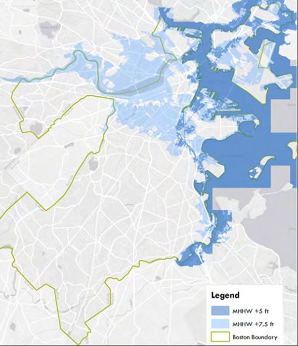
Flood Hazard Areas
Areas with a greater chance of severe flooding are known as
flood hazard areas. For purposes of federal and State law and
policy, they are known to be areas where there is a 1% annual
chance of flooding (aka the “100-year floodplain” or “FEMA Zone
A”), or a 1% annual chance of flooding and an additional hazard
associated with storm waves for coastal areas (aka “100-year
floodplain” or “FEMA Zone V”).
The city wide map titled “Flood Zones” shows the location of
both FEMA Zones A and V (this map shows the official designa-
tions prior to the anticipated new FEMA maps to be issued in the
fall of 2015, and effective in spring of 2016). These areas tend to
be associated with major freshwater or coastal surface water
bodies, such as Boston Harbor, Dorchester Bay, the Charles River,
the Neponset River, and the Muddy River. The Flood Zones map
also shows open space in the city, and these areas often overlap.
Major exceptions tend to be found along coastal areas, such as
the downtown, East Boston, Charlestown, South Boston, and
Dorchester waterfronts. Flood hazard areas not within desig-
nated open spaces are found in some smaller inland areas in East
Boston, West Roxbury, Hyde Park, and the Kenmore
sub-neighborhood.
Many of the flood hazard areas are found within protected open
spaces, ensuring that development in these areas, if any, will be
limited. In those flood hazard areas not within open spaces,
protected or not, such sites are typically highly developed.
Whatever redevelopment takes place in such areas will be the
subject of the State Wetland Protection Act and other laws
affecting development in flood hazard areas. Flood hazard
mapping is periodically revised to reflect changing flood risk
factors such as sea level rise. Such a map revision is currently
underway at the time of this writing.
44Open Space & Recreation Plan 2015–2021
!
!
! !!
!
!
!
!
!
! ARLINGTON RE VERE
EVERE TT
! ! !
!!
! !!
!
! !
CH E LSEA
!
BELMONT
!
SOM ERVILLE
¡
!
WINTHROP
WAT E R T O W N CA MBR I DG E
BROOKLINE
NE WT ON
QUINCY
M I LT O N
DE DH AM
100 Year Floodplain Open Space
Flood Zones
WE STWOOD City of Boston
¯
BRAINTREE
CA N TON Prepared by the City of Boston
Martin J. Walsh, Mayor
0 0.5 1 2 3 December 2014 Parks & Recreation Department
Miles
45Section 4 – Environmental Inventory & Analysis
Section 4.4: also help control stormwater and filter pollutants from urban
VEGETATION runoff. Healthy forest communities are essential for preventing
excess sedimentation of waterways, wetlands, storm sewers, and
catch basins by stabilizing erodible soils and steep slopes.
Introduction Many of Boston’s forested areas are open to the public providing
The natural vegetation of Boston is chiefly influenced by the
both formal and informal environmental education opportuni-
city’s geographic position along the Atlantic coast, the presence
ties to schoolchildren, families, and adults. Recreational activities
of landforms resulting from glaciation, and a long history of
such as hiking, trail running, cross country skiing, wildlife viewing
human land use and manipulation of native habitats.
and tracking, and nature photography offer city residents and
visitors the unique opportunity to experience and observe
Upland Vegetation nature up close within the confines of an urban environment.
Forested Uplands Though many of these areas are publicly owned and protected
The Boston area, like most of eastern Massachusetts, lies in the from outright development, they still suffer from a host of
Appalachian oak-hickory forest zone. This forest type occurs from problems. Some, such as the Stony Brook Reservation, have been
southern Maine, throughout southern New England, south to fragmented by the construction of parkways, creating more
Georgia at higher elevations, and west to western New York. Red, edge habitat, less interior habitat, and interrupting established
white, and black oaks, with lesser densities of pignut, shagbark, wildlife corridors.
bitternut, and mockernut hickories are species found in the plant The habitat value of all forested areas is seriously degraded by
communities that dominate the Appalachian oak-hickory forest the prevalence of non-native, invasive plant species. These plants
zone. Other trees commonly found are white ash, black cherry, were either purposely or accidentally introduced to the area and,
black birch, hophornbeam, and red maple. because of their tolerant and hardy nature, have become major
Numerous species of shrubs including lowbush blueberry, threats to the sustainability of native forest ecosystems. Among
maple-leafed viburnum, witchhazel, flowering dogwood, and the most destructive non-native invasive plants in Boston forests
beaked hazelnut. are Norway maple, Japanese knotweed, European buckthorn,
multiflora rose, Asiatic bittersweet, and Japanese barberry. In
In Boston, the oak-hickory forest is mixed with patches of other addition, people sometimes subject forested areas in Boston to
forest types found in adjacent northern and southern regions. direct abuse. Severe littering, illegal dumping, vandalism, and
Elements of the northern hardwood forest, such as sugar maple, trampling by foot and vehicles are chronic problems in many
eastern hemlock, yellow birch, and American beech can be urban forests.
found in Boston’s forested areas, especially on north and west
facing ridges. These species are generally prevalent throughout Serious pests, blights, and diseases currently threaten several
northern New England and southeast Canada. tree species. Most notable is the marked decline of the eastern
hemlock caused by an insect parasite, the wooly adelgid. More
Conversely, areas in the city with well-drained, sandy soils and recently, in 2014, the Emerald Ash Borer has been found in
southeast exposures support woodland species more typical of Suffolk County, placing another important canopy tree species at
Cape Cod and other coastal areas, such as pitch pine, scrub oak, risk for decline. This discovery, along with the early detection in
and sweet fern. White pine is a ubiquitous species throughout 2010 and successful containment from 2011 to 2014 of the Asian
the region, frequently occurring in abandoned pastures and Long-Horned Beetle, have raised public awareness about threats
other open, sunny locations. to the City’s tree canopy and overall environmental health.
Given the long history of industrial and residential development Conservation through public ownership by itself is insufficient
within Boston, it is not surprising that natural forests and other to protect Boston’s forests from degradation. Funding, staffing,
native plant communities occur today in remnants and small and active, hands-on management is also required to ensure
patches. The largest forested area remaining in the city is the the long term sustainability of Boston’s forests. Non-native,
466-acre Stony Brook Reservation in Hyde Park, Roslindale, and invasive plants need to be controlled, eroding soil needs to be
West Roxbury. stabilized and revitalized, and native species of trees and
shrubs must be planted in order to restore a healthy forest
Other significant forested areas are Allandale Woods (100 acres,
ecosystem. Early detection, control, and monitoring of invasive
West Roxbury), Hancock Woods (55 acres, West Roxbury), Sherrin
plants, pests, blights, and diseases must play a larger role in
Street Woods (25 acres, Hyde Park), the Wilderness (100 acres,
parks management.
Franklin Park), Olmsted Park (50 acres, Jamaica Plain), Brook Farm
(120 acres, West Roxbury), parts of the Arnold Arboretum In addition, activities that damage the forests—illegal dumping,
(Jamaica Plain), and sections of several Boston Harbor Islands. fires, uncontrolled mountain biking, and off-road vehicles—must
be curtailed, while beneficial and productive recreational and
Boston’s forests provide a range of recreational, scenic, and
educational activities are promoted. It is of paramount impor-
ecological benefits. They are the city’s lungs, cleansing the air of
tance to maintain the remaining forests to maximize the benefits
carbon dioxide and producing oxygen. Summer temperatures
they provide and ensure that they continue to function as viable
are up to ten degrees cooler in city forests, helping to mitigate
ecosystems for future generations.
the warming effects of urban development and activity. They
46Open Space & Recreation Plan 2015–2021
The global warming phenomenon will also affect plant hardiness
zones. The effect of rising temperatures, and the impact on the Wetland Vegetation
growth of invasive plant species and pests, diseases, and blights Freshwater Wetland Vegetation
could negatively affect some native species’ sustainability. As throughout all of Massachusetts, Boston has lost a substantial
Non-Forested Uplands percentage of its original freshwater wetlands to development.
Intense filling and subsequent construction has occurred in the
Non-forested uplands, primarily meadows, are a dwindling extensive marshes once found along Stony Brook, Bussey Brook,
resource in Boston. Often a remnant of past agricultural use, and the upper Charles River. Isolated wetlands, bogs, vernal pools,
virtually all meadows and pastures throughout the city have and small ponds have been filled for residential development.
been subject to intense residential and commercial develop- Remaining wetlands have been affected by changes to hydrology
ment. Most of those not developed have been left to grow into as streams have been buried and diverted to storm sewers.
shrubby thickets and early successional forests dominated by
non-native, invasive plant species. Wetlands serve a vital function for the city. They help to store,
control, and cleanse stormwater run-off, a function that becomes
Meadows and pastures provide critical habitat to many species increasingly important as additional impervious surfaces are
of plants and wildlife that are rarely found in Boston and are created. They also provide essential habitat for a wide array of
increasingly uncommon throughout the northeast. These wildlife (see Section 4.5).
habitats offer great scenic value, breaking up the monotony of
dense residential areas and providing expansive views of the city, Several distinct plant communities are present in freshwater
Boston Harbor, and the surrounding landscape. Boston’s mead- wetlands in Boston. Forest wetlands—such as red maple swamps
ows are frequently found atop hills and other steep slopes and floodplain forests—are typified by large trees, such as red
subject to erosion problems. Viable, healthy meadow plant maple, willows, basswood, green ash, silver maple, and a diverse
communities are thus important to stabilize vulnerable soil. shrub layer of dogwoods, alder, winterberry holly, viburnums,
and swamp azalea.
Significant upland meadows today can be found in the Arnold
Arboretum, Franklin Park, the Boston Nature Center, Calf Pasture, An outstanding remnant of the southern New England flood-
the Walter Street Tract, Allandale Farm, and on several Boston plain forest, a rare community type recognized by the
Harbor Islands. Most of these sites are current or former agricul- Massachusetts Natural Heritage Program, occurs along the
tural or horticultural sites. Turf grasses and opportunistic Charles River shoreline of Millennium Park in West Roxbury.
wildflower species of Eurasian origin are dominant. Farmers Other significant forested wetlands are found in the Stony Brook
during the 17th and 18th centuries deliberately or accidentally Reservation, Brook Farm, Sherrin Street Woods, and Leatherbee/
introduced these species and turf grasses. Hancock Woods.
The acreage of meadow found in Boston increased substantially Non-forested wetlands – marshes, shrub swamps, and wet
in 2000 with the opening of Millennium Park, a new park on top meadows – are dominated by shrubs, such as buttonbush,
of the former Gardner Street landfill in West Roxbury. This highbush blueberry, dogwoods, and elderberry, along with an
100-acre park includes over 70 acres of grassland comprised of extremely diverse collection of grasses, grass-like plants, and
both native and Eurasian grass species. herbs typified by cattails, water willow, pickerel weed, arrow
arum, bulrushes, and sedges. Typical marshes are found at
Because of the suppression of natural wildfires and the disap- Allandale Woods, West Roxbury High School, Brook Farm, along
pearance of farming practices such as haying and grazing, the West Roxbury stretch of the Charles River, and the Boston
meadows now require regular intentional maintenance to Nature Center.
sustain their open, pastoral character. Mowing is the most
common method of maintenance; however in many cases Coastal Wetland Vegetation
mowing is done too frequently to allow for the development of a Coastal wetlands, primarily salt marshes in Boston, were once the
diverse meadow plant community. Such areas are generally most dominant plant community within the city. Thousands of
devoid of any habitat value. To maximize floristic diversity and acres occurred along the harbor shoreline and up into the
ecological value, most meadow habitats should be mowed only estuaries of the Charles, Chelsea, Mystic, and Neponset Rivers.
once per year, at the most, in the late summer. Over the past 350 years, these salt marshes have been lost to
The Parks Department through its Urban Wilds Initiative, con- filling, alterations to hydrology, pollution, and other drastic
ducts selective, low-impact mowing regimes at several meadows changes to the shoreline. Today only about 400 acres of salt
throughout the city’s urban wilds and other natural areas. marsh remain. These are primarily found at the DCR’s Belle Isle
Community groups and other volunteers have also been and Neponset River Reservations in East Boston and Dorchester,
involved in introducing native meadow plants, such as golden- respectively, and at Massport’s Wood Island Marsh in East Boston.
rod and aster, and controlling non-native, invasive plant species Salt marshes comprise one of the richest and most biologically
at many sites. productive ecosystems on Earth. The precisely balanced cycles of
tide, sedimentation, and decomposition all contribute to the
production of up to ten tons per acre per year of vital nutrients,
minerals, and organic material to nearby aquatic and terrestrial
47Section 4 – Environmental Inventory & Analysis
habitats. Healthy salt marshes support dozens of animal species. Further, trees consume and store carbon through absorption of
Some species (ribbed mussel, salt marsh dragonfly, fiddler crab, carbon dioxide, and produce oxygen. By this carbon sequestra-
for example) are restricted to this habitat for the duration of their tion, the return of carbon to the atmosphere is slowed, especially
lives, while other animals (sharp-tailed sparrow, mummichogs, if the tree is long-lived. Thus, the urban forest can help contrib-
meadow vole) use salt marshes for breeding or feeding but can ute to the slowing of global warming.
also be found in other habitats.
Current Initiatives
Overwhelmingly dominated by salt marsh cordgrass and salt
The city of Boston Climate Action Plan has established a target of
meadow grass, salt marshes also protect sensitive, low-lying
reaching 35% tree canopy coverage in the city by 2030. To meet
coastal areas from flooding and other damage resulting from
this goal, a detailed, actionable, Tree Canopy Plan that incorpo-
strong storms. They are vital to the maintenance of clean water
rates the City of Boston’s Comprehensive Public Shade Tree
in Boston Harbor. Other plants adapted to withstand the unique
Policy must be developed by government agencies and our
physical conditions in and around salt marshes include marsh
non-profit and private sector partners.
elder, black rush, spike grass, glasswort, and sea lavender.
Substantive tree canopy expansion can only be achieved
Both coastal and freshwater wetlands are particularly suscepti-
through coordinated efforts to develop new policies that will
ble to the deleterious effects of urban development because
better protect existing trees, both public and private, as well as
they form the interface between surface waters and groundwa-
grown and sustain new trees. The Boston Urban Forest Council, a
ter and developable or developed uplands. Public ownership
group of non-profit, city, state, and federal organizations working
alone is insufficient to protect them and preserve the vital
to improve the urban forest ecosystem, public health, and the
functions they provide.
quality of life for Boston’s residents, can play a key role in
All of the wetlands occurring in Boston are degraded to a certain advancing tree canopy goals in the city.
extent. They have been at least partially filled or drained, have
In addition to caring for trees in its own parklands, the Parks
received either too much or too little water, have been subjected
Department is the agency with regulatory and operational
to pollutants, and have been invaded by non-native, invasive
responsibilities for city-owned shade trees in the street
plants that have out-competed the native species. The most
right-of-way. The ability to develop policy and day-to-day
destructive non-native plants in Boston wetlands are giant reed
management plans in the same organization, the Parks
(Phragmites australis) and purple loosestrife.
Department, is a key part of the framework to ensure that the
The City of Boston is pursuing a number of programs to restore future of Boston is green.
some natural functions to the city’s degraded wetlands. The
prime example of this is the restoration of the Muddy River and Statutory Responsibility and Regulations
Back Bay Fens. This project, estimated at $43 million, aims to The Parks Commissioner is by statute (Chapter 87, Massachusetts
remove years of accumulated sediment and restore a diverse General Laws) the Tree Warden of the city. Together with the
native wetland plant community. Superintendent of Trees, the Commissioner is responsible for
establishing a work plan for trees within the statutes and
The Condor Street Urban Wild in East Boston was a major
regulations that have already been established.
remediation and salt marsh restoration project completed in
2003. It resulted in the removal of hazardous materials, the The City is in the process of revising its public shade tree policy,
creation of a healthy salt marsh, upland meadow, pier, sculpture, in order to make all regulations, technical specifications, opera-
pathways, benches and scenic overlooks for habitat and passive tions, and programs current.
recreation uses.
Inventory, Planting, and Maintenance
The Belle Isle Coastal Preserve in East Boston, was completed in
Over the Parks Commission’s 130-year history the tree inventory
2005 and culminated in the remediation and restoration of a
has been replenished through budget expenditures on improve-
previously degraded salt marsh, the reconnection and re-inte-
ments to streets and parks. With the exception of the Emerald
gration of land within the vast DCR Belle Isle Marsh Reservation,
Necklace, little data existed to substantiate a sense among
and the construction of a trail segment for the future East Boston
advocates that the inventory contains too few young trees
Greenway extension.
relative to the percentage of mature trees. A visual inspection of
streets provided subjective confirmation; however, the exact
Public Shade Trees number, condition, and age of the canopy was unknown.
The urban forest is an ecosystem that provides benefits such as Inventory
filtering dust, pollution, and the harmful rays of the sun, providing With increasing competition for funding, the ability to identify
shade, protecting people and property from wind and weather, critical problems quickly and efficiently has become crucial for
reducing air conditioning and heating costs for adjacent buildings, the Parks Department. Through the use of inventory analysis, the
helping to filter storm water, and generally contributing to the city foresters can identify problems, or potential problems, easily
physical well-being of the city’s residents. Street trees also link and develop and implement precise and accurate management
highly developed spaces with more forested areas. plans. The most recent street tree inventory was compiled
in 2007.
48You can also read