Manchester Bolton & Bury Canal - Restoration - Feasibility & Impact Study Canal & River Trust - Canal & River Trust
←
→
Page content transcription
If your browser does not render page correctly, please read the page content below
Manchester Bolton & Bury Canal
Restoration - Feasibility & Impact Study
Canal & River Trust
22 March 2021

5202009-XX-ZZ-CE-RP-S-0001
Notice
This document and its contents have been prepared and are intended solely as information for Canal & River
Trust and Manchester Bolton & Bury Canal Society for use in relation to demonstrating the case for the
restoration of the canal described.
SNC-Lavalin assumes no responsibility to any other party in respect of or arising out of or in connection with
this document and/or its contents.
This document has 67 pages including the cover.

Document history
Document title: Restoration - Restoration - Feasibility & Impact Study
Document reference: 5202009-XX-ZZ-CE-RP-S-0001
                                                 Origin-                             Author-
  Revision         Purpose description            ated      Checked   Reviewed        ised            Date
 P01.1         FIRST DRAFT                         NH         SB          -              -         12/11/2020
 P01.2         AMENDED DRAFT                       SB         DB                                   03/12/2020
 P01           DRAFT ISSUE                       SB/PM        DB         SB             SB         21/12/2020
 P01           FINAL ISSUE                       SB/PM        DB         SB             SB         08/02/2021
 P02           SECOND ISSUE                      SB/PM        DB         SB             SB         22/03/2021

Client signoff
 Client                   Canal & River Trust
 Project                  Manchester Bolton & Bury Canal
 Job number               5202009
 Client
 signature/date

5202009-XX-ZZ-CE-RP-S-0001 | P01.1 | 22 March 2021
SNC-Lavalin | MB&B Canal Feasibility and Impact Study_P02                                              Page 2 of 67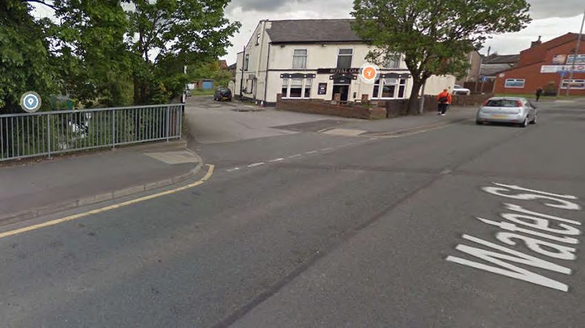
Contents
Chapter                                                                            Page
Executive Summary                                                                       5
Background                                                                              6
1.      Engineering                                                                     7
1.1.    Introduction                                                                    7
1.2.    Bolton and Bury Termini                                                         7
1.3.    Restoring the navigable channel                                                 9
1.4.    Canal Feeder                                                                   11
1.5.    Water Street Re-bridging                                                       12
1.6.    Cost estimates                                                                 18
2.      Environmental                                                                  19
2.1.    Consultation                                                                   19
2.2.    Biodiversity                                                                   19
2.3.    Air Quality                                                                    22
2.4.    Noise and Disturbance                                                          23
2.5.    Geology, Hydrogeology and Soils                                                24
2.6.    Cultural Heritage                                                              25
2.7.    Landscape and Visual Amenity                                                   26
2.8.    Surface Water                                                                  27
2.9.    Recommendations                                                                28
3.      Consultation Responses                                                         30
3.1.    Introduction                                                                   30
3.2.    Technical issues                                                               30
3.3.    Responses                                                                      30
3.4.    Summary of Survey responses                                                    30
4.      Planning Policy Review                                                         36
4.1.  The National Planning Policy Framework – Ministry for Housing, Communities and Local
Government, February 2019                                                               36
4.2.  Bolton Local Development Plan                                                     38
4.3.  Bury Local Development Plan                                                       39
4.4.  Conclusions                                                                       42
5.      Socio-economic case for restoration                                            43
5.1.    The Need for the MB&BC Restoration and Redevelopment                           43
5.2.    The Wider Regeneration Context                                                 44
5.3.    Regeneration Outcomes                                                          47
5.4.    Value of Economic Benefits                                                     53
6.      Restoration Options                                                            56
6.1.    Restoration Options                                                            56
7.      Funding Opportunities                                                          59
7.1.    Funding the Manchester Bolton & Bury Canal Restoration                         59
8.      Conclusions                                                                    61

Appendices                                                                             63

5202009-XX-ZZ-CE-RP-S-0001 | P01.1 | 22 March 2021
SNC-Lavalin | MB&B Canal Feasibility and Impact Study_P02                                    Page 3 of 67
Appendix A.         References                                                                   64
A.1.    Documents provided as the basis for this study                                           64
Appendix B.         Environmental Designations Plan                                              65
Appendix C.         The Breach - Watson Homes proposals (not part of this study)                 66

Tables
Table 2-1 – Summary of the key ecological constraints and potential impacts                      21
Table 2-2 – Listed Buildings                                                                     25
Table 5-3 – Regeneration outputs and outcomes                                                    46

Figures
Figure 1 - Showing the much wider scope of earlier studies and identifying this study's extent    6
Figure 2 Overview of key elements of work at Hall Lane Basin                                      8
Figure 3 Overview of key elements of work at Proposed Daisyfield Basin                            9

5202009-XX-ZZ-CE-RP-S-0001 | P01.1 | 22 March 2021
SNC-Lavalin | MB&B Canal Feasibility and Impact Study_P02                                             Page 4 of 67
Executive Summary
This feasibility report brings up to date earlier studies for restoration of the Manchester Bolton & Bury Canal but
unlike earlier studies it focuses only on the 5 miles of canal between Bolton and Bury. The breach section at
Little Lever and the adjacent infilled length from Nob End are not covered by this report because restoration
here is being progressed as part of, and subject to planning approval for, a proposed residential development
by Watson Homes.

The canal in this feasibility report terminates outside the centre of Bolton and of Bury. At Bolton the demolition
of several aqueducts has resulted in the logical terminus being at Hall Lane Basin close to Moses Gate Country
Park. At Bury the canal terminates south of Wellington Street although longer term ambitions could see the
canal extend towards the centre as part of future redevelopments.

Since 1987 the Canal Society have successfully managed fund raising and volunteer working parties to
maintain and keep much of the canal in water. Because the canal is severed in two places, the breach and
Water Street, it has failed to make significant progress as a local amenity with this potential further held back by
restriction on public spending since 2008.

This report examines the engineering challenges to be overcome to restore the canal as described above for
amenity boating traffic and towpath use. This include elements of maintenance and repair, dredging, leak
repair and tree clearance but the most significant element of work required is the restoration of the canal under
Water Street. Here a 60-metre length of canal has to be restored by raising and re-bridging the A665, a 4-lane
carriageway near the centre of Radcliffe. Updated costs have been developed against all identified works
totalling £6.06 million.

A targeted consultation with local stakeholders and other bodies was carried out to inform the report on local
opinions concerning the canal restoration. In the time that was allowed for this process to feedback a total of
88no. responses were received which were overwhelmingly positive. Many of the consultation responses
raised common points and concerns at how the restoration could be directed.

The planning policy framework for both Bury and Bolton is supportive of restoration of the canal and towpath
along this route and such activity would help fulfil several the national and local planning objectives. In
particular improving the attractiveness of local environs and improving health and wellbeing through provision
of accessible green/blue infrastructure and opportunities for recreation, walking and cycling. Measures to
restore the canal should recognise its high wildlife and biodiversity value and ensure the canal is accessible to
all users including those with disabilities.

Socio-economic benefits to the value of £1 million per annum will accrue to Bolton MBC and Bury MBC areas.
This indicates that the cost of restoration can be recouped within the local economy within 8 years and will then
continue on an annual basis. These benefits will flow, in particular, to Farnworth, Kearsley, Little Lever,
Radcliffe, and Bury Town Centre as these areas are closest to the canal.

Although the restoration of the 5-mile length of the canal is the objective of this study a series of options are
presented to make increased use of the canal while the obstacles at Water Street and the breach are being
resolved. The source of funds to realise the restoration is discussed at the end of this study.

This report confirms the feasibility and overwhelming positive impacts that the restoration of this short section of
canal can achieve. Opportunities for funding such a scheme have been limited for several years but now the
many benefits that restoration can bring for the local community are better understood. With the clear support
of local businesses and councils this scheme should have renewed impetus for delivery.

5202009-XX-ZZ-CE-RP-S-0001 | P01.1 | 22 March 2021
SNC-Lavalin | MB&B Canal Feasibility and Impact Study_P02                                                 Page 5 of 67
Background
The Manchester Bolton & Bury Canal was built between 1791 and 1808 at a cost of £127,700. It was originally
planned to be for narrow boats but during construction it was redesigned as a broad canal. The canal was
officially abandoned in 1961. A society was formed in 1987 with the intentions of restoring the canal so that it
can be used for leisure and contribute to local regeneration. The canal’s water is supplied by the Elton
Reservoir via a feeder channel that although largely intact requires some refurbishment.
Earlier studies from 1996 and 2004 addressed the restoration of the full Manchester Bolton & Bury Canal
whereas this study focuses on the approximately 5 mile stretch of canal from Wellington Street in Bury, through
Radcliffe to Hall Lane Basin, Little Lever (outlined in red below). In this stretch of canal, there are no locks, and
with the volunteer efforts of the society, 4 of the 5 miles are in-water.

Figure 1 - Showing the much wider scope of earlier studies and identifying this study's extent

The majority of the land in the study area is owned by Canal and River Trust, some of the land is privately
owned and the remainder is owned by the local authority. In the residential areas surrounding the canal, there
are approximately 150,000 people that are within a 5-minute cycling distance; many of these residents have
several deprivation needs which are above the national average.
There is a towpath alongside the canal which has been resurfaced for the majority of the length with some
section a restored cobbled surface that is in good condition. The canal is also of heritage value and has
multiple listed milestones along with a Grade II listed Steam Crane.
All areas of the canal that are in-water are Sites of Biological Interest (S.B.I.) and have significance as an
environmental and ecological resource for wildlife with the consequent benefits for people. Furthermore, Nob
End Nature Reserve is a designated SSSI and Local Nature Reserve.

5202009-XX-ZZ-CE-RP-S-0001 | P01.1 | 22 March 2021
SNC-Lavalin | MB&B Canal Feasibility and Impact Study_P02                                                 Page 6 of 67
1.           Engineering
1.1.         Introduction

The purpose of this study is to review and update relevant sections of the existing canal restoration studies
listed in Appendix A and provide evidence for the Manchester Bolton & Bury Canal Joint Steering Committee in
attracting external funding to complete the restoration of a continuous canal with a length of approximately 5
miles between Bolton and Bury.
Included is an overview and costing of the key engineering works and facilities required to achieve the objective
with a discussion of some options that may be used for phasing delivery.
This report assesses the feasibility of the restoration with a summary of the potential impacts and outcomes of
the restoration on the community, prosperity, area and wildlife, and a summary of the financial evidence behind
the cost benefits coming from potential restoration options.
Approximately one third of a mile is under private ownership and therefore separate designs are being made for
this part of the canal along with engineering options to dam the top of the Nob End Lock. This privately owned
area also contains the site of the 1936 canal breach at Creams Paper Mill.
Effectively the proposed 5 miles of restored continuous canal presently comprises three lengths of canal in-
water separated at two locations: the breach at Little Lever and the Water Street (A665) road crossing at
Radcliffe.
Engineering aspects of the canal restoration are covered under the following headings.
1.2 Bolton and Bury Termini
1.3 Restoring the navigable channel
1.4 Canal Feeder
1.5 Water Street Re-bridging
1.6 Cost Estimates

1.2.         Bolton and Bury Termini
For the purpose of this study the primary significance of the termini is that they mark the most likely end point
for the canal restoration being considered and need to provide facility for boats to turn and moor. At least one
terminus should provide for boat launching and if a continuous canal is not available at first then additional boat
launching locations should be allowed for.

1.2.1.       Hall Lane Basin Terminus
Any further extension of the canal towards Bolton is considered unlikely because the cost of the construction of
a series of aqueducts would be prohibitive. This work was considered in earlier studies
The Hall Lane Basin is well placed to be developed to support recreational activities on the water. The basin,
fed by surface water from the local catchment has ample space for moorings, boat turning and the development
of boat launching facilities.
Access from the nearby public highway 90 metres (A6053) needs to be widened and upgraded to provide
adequate safe turning for vehicles used to transport boats for launching. Access may also be better provided if
the proposed Watson housing development goes ahead, reducing access costs. There are also opportunities to
enhance active travel links through this terminus with the adjacent Moses Gate Country Park. Any proposals
need to be reviewed to identify conflict with existing land ownership.
Parking for cars, welfare facilities and construction of a slipway for trailer mounted boat launch complete the
basic provision at this location. It is assumed that cranes used to lift larger boats into the water can be sited
away from the canal edge so a concrete slab to distribute load should not be needed.
Development of this terminus has little purpose until the breach section is restored because it enables access
to less than 1 mile of canal. There may however be merit in developing the access at an early stage to support
dredging and other engineering works and to enable some local boating.

5202009-XX-ZZ-CE-RP-S-0001 | P01.1 | 22 March 2021
SNC-Lavalin | MB&B Canal Feasibility and Impact Study_P02                                                 Page 7 of 67
Figure 2 Overview of key elements of work at Hall Lane Basin

1.2.2.       Daisyfield Terminus
Whilst there is some potential for developing an extension of the existing canal further north there are
difficulties and limited clear benefits in doing so. For the purposes of assessing a baseline option this study
considers the terminus to be located at or close to the existing end of the canal presently in-water.
There is no natural basin presently. This option requires the excavation and formation of a widened area that is
sufficient for the turning and mooring of boats. This site could readily also include a slipway for boat launching.
Approximately 500m of new access from the public highway will be needed. This new access is likely to
closely follow the previous line of the canal but consideration must be given for a future canal extension and
impacts on adjacent land ownership.
Similar to the Hall Lane Terminus a provision for car parking and welfare facilities as a minimum have been
allowed for as part of the feasibility requirement.
A viable option to improve access would be extending the towpath with a 3m wide shared use path including
new shared use bridge across the River Irwell to link with Bury Town Centre.
An extension of the canal towards Bury is complicated by later property and highway developments that leave
very limited space between Wellington Street and the River Irwell and buried utilities that may need to be
diverted at significant cost.

5202009-XX-ZZ-CE-RP-S-0001 | P01.1 | 22 March 2021
SNC-Lavalin | MB&B Canal Feasibility and Impact Study_P02                                               Page 8 of 67

Figure 3 Overview of key elements of work at Proposed Daisyfield Basin
1.3. Restoring the navigable channel
This section addresses the works needed to achieve a navigable channel.
The main points here are:
tree work to remove or cut back trees and other significant vegetation overhanging the channel and
affecting retaining walls.
dredging to ensure the channel is clear of debris and provides sufficient depth for all boats permitted to use
the canal. This work to include for removing reed growth from the navigable channel only.
water level security – identify any leaks in the wash walls resulting from tree removal and dredging and
exploring optimum water level.
5202009-XX-ZZ-CE-RP-S-0001 | P01.1 | 22 March 2021
SNC-Lavalin | MB&B Canal Feasibility and Impact Study_P02 Page 9 of 67
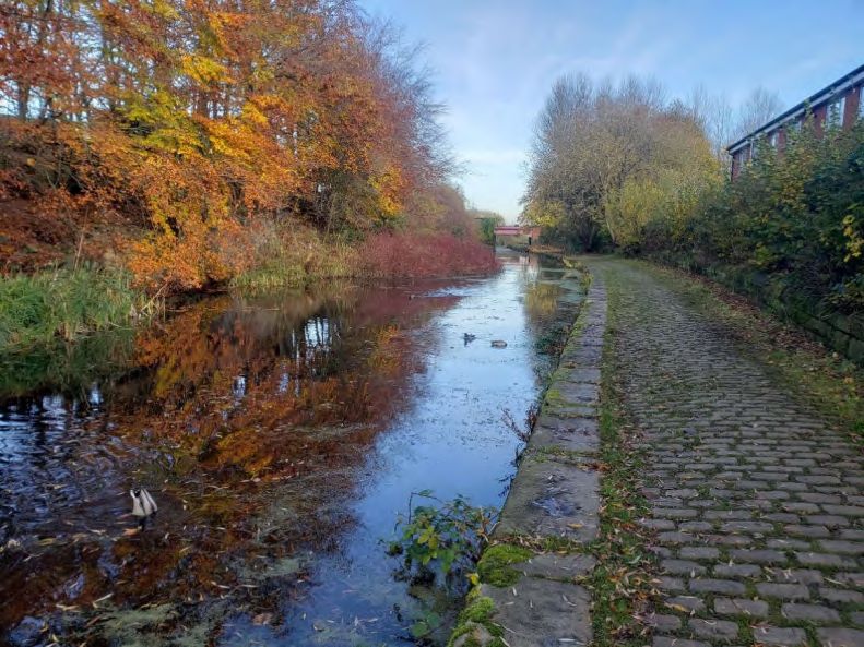
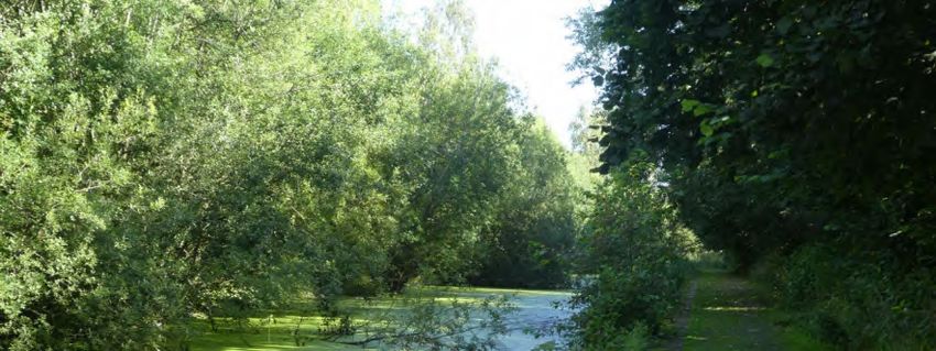
1.3.1.       Tree Work

The scale of work required over the full 5 mile length is considerable through lack of maintenance over the
years but the majority of work over and alongside the canal is between the breach and Radcliffe.
Environmental considerations and surveys required are discussed in Section 2.

Photograph 1 - Trees encroaching across canal at Radcliffe

The majority of tree work required is on the north bank of the canal opposite the towpath. In some cases tree
branches reach across almost the full width of the canal. In addition some crown lifting and further tree removal
will be required to open up areas where the tow path is overshadowed. Also a full survey of retaining walls
through Little Lever will be needed to identify areas compromised by tree roots.
Works can be phased to take advantage of access points developed at the Hall Lane and Daisyfield termini, at
Water Street and at Creams Paper Mill.

1.3.2.       Dredging
The objectives for dredging are to provide a navigable channel to an acceptable depth and width for users but
maintaining reed margins to the north bank where possible. Typically dredging will include for removing
isolated reed beds alongside the towpath. A bathymetric survey will be required to quantify the volumes of
material to be removed.
It is not considered necessary to dredge to excess to achieve a healthy navigable depth so there will still be a
significant depth of undisturbed sediment and leaf litter covering the original canal bed lining. Dredging depth
will be guided to meet acceptable maintenance requirements in the development of this asset. In turn the
operating water level needs to be established during restoration accepting that higher water levels are likely to
expose more wash wall leaks.

5202009-XX-ZZ-CE-RP-S-0001 | P01.1 | 22 March 2021
SNC-Lavalin | MB&B Canal Feasibility and Impact Study_P02                                              Page 10 of 67
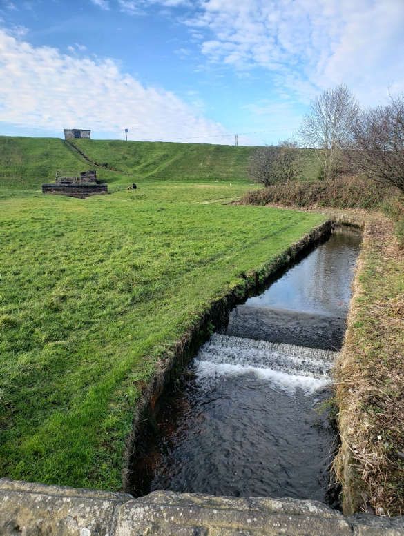
1.3.3.       Water Level Security
It is assumed that leaks through the wash walls will need to be managed during the restoration works. These
leaks may be caused by the removal of bankside vegetation or existing leaks may be exposed by increasing
the water level. Water lost to leaks in the canal need to be minimised because (a) it can put an unnecessary
demand or exceed demand for the canal feed and (b) leaks can disturb the stability of structures or
embankments that support the canal.
Following dredging and after all identifiable leaks have been repaired it is assumed a programme of
incremental water level raising and leak location. This work will identify a suitable water level for operation
within the constraints an acceptable rate of loss.

1.4.         Canal Feeder
The canal feed from Elton Reservoir is the main feed for the canal and is maintained by Canal & River Trust
however under present conditions the feed is not regulated for canal use and in the Summer water levels drop
below the main spillway opposite the feed entry.
The feed to Elton Reservoir from Burrs Country Park has benefitted from some maintenance and a recent
community clean up between Brandlesholme and Tottington Roads but this was not included as part of the
scope for this study.
Earlier studies have been prepared on the basis of a wider regeneration of the canal system including for the
locks at Nob End. Water demand for this restoration will be considerably less but would ideally see an increase
in the flow of fresh water along the canal. This is turn will require a raising of water levels managed by
refurbishment of stop planks and sluices.
Opportunities for the canal contributing to flood risk management, particularly where this may generate funding,
should also be explored where the canal and Elton Reservoir might be used for flood storage or for dispersal of
peak flows.
Assessment of the potential for Elton Reservoir confirms that the 5-mile section of canal between Bury and
Bolton covered by this study can be adequately served. Survey of the sluice and controls for the discharge
from the reservoir will be required along with modest maintenance work to the channel to secure this asset for
the purposes of the canal.

5202009-XX-ZZ-CE-RP-S-0001 | P01.1 | 22 March 2021
SNC-Lavalin | MB&B Canal Feasibility and Impact Study_P02                                               Page 11 of 67
Photograph 2 – Canal Feeder looking toward Elton Reservoir

1.5.         Water Street Re-bridging
1.5.1.       Background
Re-bridging at Water Street has been considered before and some detail has been provided here for updating
from the studies in 1996 and also in 2004.
The 1996 study presented an outline design for a new bridge comprising steel beams and a concrete deck with
retaining walls extending 120 metres each side to allow for raising the carriageway a maximum of 1.5 metre for
adequate canal headroom. The cost was estimated at £2m, this allowed for utility diversions but excluded the
cost of resolving uncertainty for the foundations needed and the difficulties maintaining access to some local
roads. This 2020 update is based on the detail provided for the 1996 study.
Less information is available about the 2004 study but the outline design is changed to be a large concrete
culvert with a similar vertical alignment and need for retaining walls and a cost estimate of £1.816m.

5202009-XX-ZZ-CE-RP-S-0001 | P01.1 | 22 March 2021
SNC-Lavalin | MB&B Canal Feasibility and Impact Study_P02                                           Page 12 of 67
1.5.2.       2020 Update

The 1996 estimate is reproduced below with comment and updated values as assessed.

The updated estimate for Bill Part 1 is £400,000 – which excludes the use of a temporary bridge – see
observations below.

The updated estimate for Bill Part 2 is £1,400,000
The updated estimate for the Total Main Bridgeworks is therefore £1,800,000.

5202009-XX-ZZ-CE-RP-S-0001 | P01.1 | 22 March 2021
SNC-Lavalin | MB&B Canal Feasibility and Impact Study_P02                                          Page 13 of 67
Advice was sought from the Atkins Utility team who provided the following:
Being as the report is from 25 years ago or more and that networks have changed considerably during that time
it is difficult to estimate the potential additional cost. Some of these companies have changed hands and
increased/upgraded their networks during this time and fibre is now prevalent where it may not have previously
been. There is likely to also be additional utilities in the area too. To accurately quantify utility costs a new Utility
Search Report would be required, completing a conflicts assessment and by sending out C3 applications for
the proposed scheme.
As a high level estimate the costs could be double or triple the previous costs.
Further Site Investigations will also be required.
The updated estimate for Total (others) is £1,500,000.
The updated estimate for Total (Fees) is £450,000.
The updated Total Estimated Cost is £3,750,000
1.5.3. Observations
Assumed that the proposed bridge is approx. 60m in length, with a square internal span of 7m.
Potential cost savings should be developed during the detailed design and delivery of the works. Savings
could be made by limiting the navigable width to the 3 metres proposed for the repair at the breach (see
Appendix C) and further economies may be realised by delivering alongside any planned modernisation
and resurfacing of the Water Street carriageway, footway and verges.
We question why a temporary bridge is required, could the bridge not be constructed in two halves – to
maintain traffic and pedestrian flow. Updated estimate does not include for a temporary bridge.
5202009-XX-ZZ-CE-RP-S-0001 | P01.1 | 22 March 2021
SNC-Lavalin | MB&B Canal Feasibility and Impact Study_P02 Page 14 of 67 In relation to the current highway standards, there are no significant changes from TD9/93 that would affect
this proposal.
The updated estimated costs do not include for significant ground works if poor ground conditions are
encountered.
Where diversions are carefully planned and adequately notified Canal & River Trust may be in a position to
utilise existing lift and shift agreements for diversion / removal at the undertaker’s cost.
The extract below from the 1996 report outlines the approach with regards to the affected adjacent roads
and properties due to the road levels at the structure being increased by 1500mm. It is difficult to see how
vehicular access can be maintained without any significant and costly reprofiling and junction adjustment
works as stated in paragraph 1 below, with such a change in levels. The updated cost estimate in Section
1.6 includes a contingency sum for these works that may include Knowle Street maintaining access for
residents and businesses along the adjacent unnamed road.
Extract from 1996 Report.
5202009-XX-ZZ-CE-RP-S-0001 | P01.1 | 22 March 2021
SNC-Lavalin | MB&B Canal Feasibility and Impact Study_P02 Page 15 of 675202009-XX-ZZ-CE-RP-S-0001 | P01.1 | 22 March 2021 SNC-Lavalin | MB&B Canal Feasibility and Impact Study_P02 Page 16 of 67
Extract from proposed GA drawing 2004 – showing a proposed rc box culvert.
1.5.4. Summary
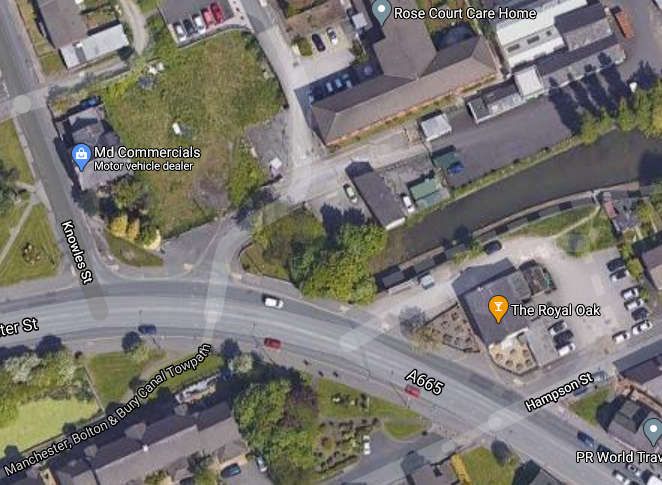
The re-bridging works at Water Street is estimated to cost £3.75m at 2020 prices.
Utility diversions contribute most to increased costs compared to previous estimates.
The existing carriageway, footways and verge footprint is considered adequate for the required works and
could realistically accommodate temporary diversions during construction.
Land take outside of the existing highway boundary will be required to accommodate changes to affected
local roads. This will be primarily at Knowles Street and some further work to reconnect with the towpath
next to The Royal Oak and at Hampson Street.
Opportunities to minimise the overall length of the canal underpass, maximise natural light and ensure
accessible links from the towpath to Water Street are maintained should be explored during detailed
design.
Options to reduce the navigable width and headroom were ruled out on account of the significant length of
the culvert and long-term safety considerations however this should be confirmed by detailed design.
5202009-XX-ZZ-CE-RP-S-0001 | P01.1 | 22 March 2021
SNC-Lavalin | MB&B Canal Feasibility and Impact Study_P02 Page 17 of 671.6. Cost estimates
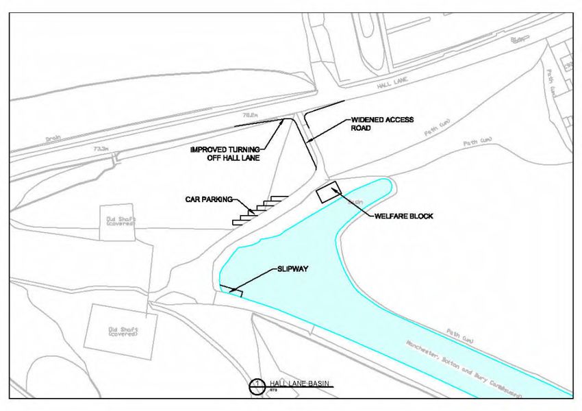
Hall Lane Basin Terminus (Bolton)
Improvements to access from highway 120,000
Welfare facilities 40,000
Parking/Active Travel facilities 20,000
Boat access 20,000
£200,000
Daisyfield Terminus (Bury)
New access from highway 250,000
Development of basin for turning and
mooring
100,000
Parking/Active Travel facilities 20,000
Welfare facilities 40,000
Boat access 20,000
£430,000
Dredging
Hall Lane to Nob End 50,000
Creams Paper Mill to Water Street 150,000
Water Street to Daisy Field 200,000
£400,000
Tree work
Hall Lane to Meccano Bridge 20,000
Creams Paper Mill to Water Street 80,000
Water Street to Daisy Field 100,000
£200,000
Feeder from Elton Reservoir
Survey of feed control 5,000
Channel and sluice maintenance 20,000
£25,000
Water Street Re-bridging 3,750,000
Contingency for junction tie-ins 300,000
£4,050,000
Miscellaneous Works
Wash wall leak repairs 100,000
Masonry Repairs Various 200,000
Feeder/Stop Planks 50,000
Fencing 20,000
Towpath 50,000
Ground Investigations 100,000
Environmental Surveys, Licences,
Mitigation and Consents 200,000
Retaining Walls 35,000
£755,000
Total £6,060,000
5202009-XX-ZZ-CE-RP-S-0001 | P01.1 | 22 March 2021
SNC-Lavalin | MB&B Canal Feasibility and Impact Study_P02 Page 18 of 672. Environmental
This section provides an overview of the existing baseline and the environmental constraints and opportunities
associated with the proposed canal restoration project. It is a high-level appraisal of environmental constraints
within the study area and identifies opportunities and recommendations for the next stage. The baseline data
has been collected by a desk-based review of readily available data from veritable sources such as the Multi-
Agency Geographic Information for the Countryside (MAGIC) website, ATKINS GO!1, Environment Agency’s
Flood Map for Planning Services and interactive maps available on Bury Metropolitan Borough Council and
Bolton Metropolitan Borough Council websites for Tree Preservation Orders (TPO) and Conservation Areas
(CA). The study area has been selected based on professional judgement. The study considers the following
environmental aspects:
Biodiversity
Air quality
Noise and disturbance
Geology and soils
Cultural heritage
Landscape and visual amenity
Water environment
Appendix B shows the locations of the identified environmental designations and constraints in relation to the
canal.
2.1. Consultation
As part of the environmental study, some limited consultation has been undertaken with Tom King, an ecologist
working for the Canal and River Trust, and David Dutton an ecologist working for the Greater Manchester
Ecology Unit. The information that they provided has been incorporated into the following sections.
2.2. Biodiversity
2.2.1. Desk Study
2.2.1.1. Study Area
The study area has been defined individually for each potential receptor based on best practice guidance, as
follows:
Statutory designated sites of nature conservation importance2 were considered within 2 km of the site.
Notable habitats, these being ‘Habitats of Principal Importance for the Conservation of Biodiversity’
included in the England Biodiversity List and ancient woodland, were identified within 500 m of the Site.
Sites of Importance for Nature Conservation (SINC) and waterbodies were also identified within 500 m from
the Site. Waterbodies were identified to 500 m as Great Crested Newts typically use suitable terrestrial
habitat up to 500 m from a breeding pond3.
2.2.1.2. Statutory Designated Sites
There are no internationally important sites for nature conservation (Special Areas of Conservation (SAC),
Special Protection Areas (SPA) or Wetlands of International Importance (Ramsar Site)) within 2 km of the
proposed red line boundary of the Scheme.
1
Atkins GO! is a geospatial tool developed for in-house use by Atkins with the ability to view some of the thousands of freely available open
datasets
2
Sites of nature conservation importance include: Special Protection Areas (SPAs), Wetlands of International Importance (Ramsar sites),
Special Areas of Conservation (SACs), Sites of Special Scientific Interest (SSSIs), National Nature Reserves (NNRs) and Local Nature
Reserves (LNRs).
3
English Nature (2001). Great Crested Newt Mitigation Guidelines
5202009-XX-ZZ-CE-RP-S-0001 | P01.1 | 22 March 2021
SNC-Lavalin | MB&B Canal Feasibility and Impact Study_P02 Page 19 of 67Sites of Special Scientific Interest (SSSI)
Nob End SSSI is noted approximately 40 m south of the canal, close to Prestolee Road, at Grid Reference
(GR): SD75010649.
Ashclough SSSI is noted approximately 180 m south of the canal at GR: SD758063 and 450 m south of the
canal at GR: SD762062, close to Prestolee Road.
Local Natural Reserve (LNR)
Moses Gate LNR is located on either side of the canal in Little Lever, covering Moses Gate Country Park to
the south at GR: SD746069 and small areas to the immediate north of the canal at GR: SD749069 and GR:
SD75040678.
Nob End LNR is located approximately 40 m south of the canal, close to Prestolee Road, at GR:
SD75010649.
Chapelfield LNR is located 1 km south of the canal, in Chapelfield, at GR: SD78920639.
Leverhulme LNR is located approximately 1.5 km northwest of the canal, close to Lever bridge in Darcy
Level, at GR: SD73610855.
Clifton Country Park LNR is located approximately 2 km south of the canal, in Clifton, at GR: SD77240450.
There are no other nationally important sites for nature conservation (National Nature Reserves (NNR)) within
2km of the proposed canal route.
2.2.1.3. Waterbodies / Watercourse
The Manchester Bolton & Bury Canal
River Irwell, an Environment Agency (EA) designated main river, runs parallel to the canal boundary to its
south and appears closest approximately 70 m south of the canal at GR: SD773065 and GR: SD793092.
Elton Reservoir is noted approximately 100 m west of the canal in Bury. Reservoir acts as a feeder for the
canal.
Several ponds and ditches are also noted within 500 m of the Scheme.
2.2.1.4. Sites of Biological Importance
From west to east, the following Sites of Biological Importance are located within 500 m of the site:
Darcy Lever Gravel Pit approximately 450 m north west of the canal
Bull Hill approximately 400 m west of the canal
Moses Gate approximately 400 m south west of the canal
Manchester Bolton & Bury Canal (West) located within the site
Nob End approximately 40 m south of the canal, overlapping designation with the LNR
Shore Top Reservoir approximately 240 m south of the canal
Manchester, Bolton & Bury Canal (East) located within the site
Withins Reservoir approximately 300 m west of the canal
Elton Reservoir approximately 100 m west of the canal
Elton Goyt immediately west and adjacent to the canal
Daisyfield immediately west and adjacent to the canal
Lower Hinds approximately 120 m east of the canal
Swan Lodge approximately 360 m east of the canal
2.2.1.5. Notable Habitats and Species
No Ancient Woodland was identified within 500 m of the canal boundary. The closest designated Ancient
Woodland is located at Prestolee Wood, approximately 800 m south of the canal at GR: SD76100590.
The canal extents close to Nob End - Prestolee and Little Lever – Bury have important submerged plant
communities such as spiked water-milfoil, frog-bit, broad-leaved pondweed, water starwort and greater and ivy-
leaved duckweed.
A variety of freshwater invertebrates such as great pond snail, whirlpool ramshorn, fresh water shrimp, and a
wide variety of smooth newt breeds and GCNs are also observed in both the canal and reservoir.
5202009-XX-ZZ-CE-RP-S-0001 | P01.1 | 22 March 2021
SNC-Lavalin | MB&B Canal Feasibility and Impact Study_P02 Page 20 of 67The canal also supports a variety of birds such as mute swan, mallard, coot, reed warbler, snipe, redshank,
grey heron and Canada goose. Lapwing, song thrush, tit, linnet and bullfinch are UK Biodiversity Priority
Species.
No species surveys have been undertaken or data obtained from the Greater Manchester Ecological Unit, but
the vegetation lining the canal has the potential to be habitat for a range of protected species including birds
and bats.
The canal and nearby waterbodies and watercourses have the potential to support amphibians, otters and
water voles.
There is potentially suitable badger habitat within the site.
2.2.1.6. Consultation
The limited consultation exercise revealed that the quality of aquatic habitats within the canal were generally
very good and are amongst the best examples within the Greater Manchester area. Notwithstanding this there
are issues with Invasive Non-Native Species (INNS), including giant hogweed and Himalayan balsam, which
are present across large areas of the canal and River Irwell corridor.
Parts of the canal suffer from eutrophication which has resulted in extensive stands of duckweed.
Otters have been recorded, using camera traps, in the vicinity of the canal and they are therefore likely to be
present along the canal. Further surveys would need to be undertaken to confirm this.
2.2.2. Potential Impacts
The restoration works will be temporary and localised, within the canal boundary. There will likely be a
requirement for vegetation clearance, excavation, dredging and construction etc., during the restoration works
which may have potential to impact ecological receptors.
Delivering the project’s overarching objective has the potential for an increase in traffic of boats and socio-
economic activities, with the potential for increased disturbance to wildlife.
It is noted in the previous studies related to the canal restoration works that the restoration will ensure the flow
of clean water is maintained to support and enhance the surrounding ecological features.
The possible ecological issues that could arise as a result of the proposed restoration works are summarised in
Table 2-1.
Table 2-1 – Summary of the key ecological constraints and potential impacts
Ecological Potential Impacts
Constraints /
Features
Statutory No direct impacts to any statutory designated sites. Potential for indirect effects to
Designated Sites Nob End SSSI and LNR due to the close proximity of the works to the site.
Other statutory designated sites are sufficiently far from the proposed works that
indirect impacts are unlikely.
Sites of The Manchester Bolton & Bury Canal will be directly impacted. Vegetation clearance
Biological will reduce habitat for some species, e.g. nesting birds, but the resulting
Importance improvement of the water quality could be beneficial for some aquatic species.
Dredging will be a direct impact to aquatic communities for which the canal is
designated resulting in the loss of some aquatic habitats and the disturbance of
others.
Other canal restoration projects in the Greater Manchester area have resulted in a
decline in biodiversity value. This is believed to be due to the wash from boats
disturbing bottom sediments, increasing turbidity and sedimentation which will limit
plant growth. There could be other factors at play as well, but increased boat traffic is
a likely explanation. Whilst boat traffic is likely to be limited in the MB&BC, there
could be a decline in the quality of retained aquatic habitats.
Potential for indirect effects to Nob End.
Other Sites of Biological Importance are sufficiently far away from the proposed
works that they are unlikely to be affected.
5202009-XX-ZZ-CE-RP-S-0001 | P01.1 | 22 March 2021
SNC-Lavalin | MB&B Canal Feasibility and Impact Study_P02 Page 21 of 67Ecological Potential Impacts
Constraints /
Features
Waterbodies and There is a possibility of contamination of surface waterbodies/watercourses within
Watercourses and adjacent to the canal boundary, such as River Irwell, during the restoration
works, particularly during any dredging and silt removal.
Habitats and Habitats
protected
species Submerged plant communities in the canal will be disturbed and potentially lost
during dredging works to remove silt.
Potential for a decline in quality of aquatic habitats during operation due to boat
traffic disturbing sediments, increasing turbidity and sedimentation.
Protected Species
Bats – Vegetation loss could directly impact bat roosts if any are present within trees
lining the canal. The canal could also be a foraging corridor for bats and the loss of
vegetation might impact this function. Any noisy construction works could cause a
disturbance to bats if near to roosts.
Amphibians – Works within the canal water body could disturb or kill any amphibians
present in the canal. Some amphibians are known to travel long distances from their
resident waterbodies if suitable connecting habitats are present. Great crested newts
have been recorded in nearby ponds and are a European Protected Species.
Otters / water voles – The canal is understood to support otters and has potential to
support water voles. Works could impact burrows and disturb animals. The loss of
vegetation from the banks could also impact the suitability of the canal for these
species. Loss and deterioration of aquatic habitats could reduce the value of the
canal for these species.
Nesting birds – vegetation clearance could disturb nesting birds, if clearance works
are undertaken during bird breeding season (typically April to July).
Common species of reptile - loss of grassland and scrub, within the Scheme extent
could result in the loss of habitat for foraging and refuge opportunities for reptiles.
There could also be a direct impact if reptiles are present in areas proposed to be
cleared.
Badgers – excavation and clearance works within the soft estate could impact on any
badger setts potentially located within or near to the site.
2.3. Air Quality
2.3.1. Desk Study
2.3.1.1. Study Area
Given the nature of the works, air quality impacts are not anticipated beyond 200 m from the proposed
Scheme. The desk based high level screening assessment was carried out for 200 m radius area from the Site.
2.3.1.2. Air Quality Management Area (AQMA)
The Greater Manchester Combined Authority AQMA crosses the canal at Water Street, in Radcliffe. The same
AQMA is also close to the canal (approximately 120m northwest) at Church Street, in Little Lever. The AQMA
has been declared for nitrogen dioxide NO2 associated with traffic emissions.
5202009-XX-ZZ-CE-RP-S-0001 | P01.1 | 22 March 2021
SNC-Lavalin | MB&B Canal Feasibility and Impact Study_P02 Page 22 of 672.3.1.3. Sensitive Receptors
The following receptors sensitive to air quality are located close to the canal:
Residential properties:
- Residential properties are located along the Bury road, connecting Radcliffe and Redvales, the nearest
properties to the canal are located approximately 50 m east on Withins Avenue at GR: SD791082
- Several properties are located on either side of the canal in Radcliffe, the closest properties are
towards the immediate south in Canalside Gardens at GR: SD784075 and Great Hall Close GR:
SD784076 and Gorsefield Close SD783076 on the northern bank of the canal
- In Little Lever, properties are noted along the north of the canal boundary from GR: SD784075 to
SD746070, with the nearest properties being located on Boscow road at GR: SD752065, and Ascot
road to the extreme west at GR: SD747069
Schools:
- Gorsefield Primary School and St Mary’s RC Primary School are located approximately 150 m north of
the canal on Lowton street in Radcliffe, at GR: SD782077
- Millwood Primary Special School is located approximately 50 m southeast on School Street in
Radcliffe, at GR: SD77910714
- Little Lever School is located approximately 200 m northwest of the western end of the canal boundary,
on A6053, at GR: SD746073
Cygnet Hospital is located on Buller Street in Bury, approximately 200m west of the canal boundary, at GR:
SD79100989
Rose Court Care Home, approximately 30m north of the canal boundary, is located on Water Street in
Radcliffe at GR: SD7817507498
Places of Worship:
- St Thomas Vicarage is located approximately 180m south of the canal on Spring lane in Radcliffe, at
GR: SD784073
- St Mary & St Philip Neri Roman Catholic Church is located approximately 280m north of the canal on
Belgrave street in Radcliffe, at GR: SD782078
2.3.2. Potential Impacts
Due to the nature of the works, it is not anticipated that there will be much of an impact to air quality and any
impacts will occur during construction. Potential impacts include fugitive dust emissions from any demolition,
cutting, grinding, excavations etc. and combustion emissions from any diesel plant and construction traffic.
2.4. Noise and Disturbance
2.4.1. Desk Study
2.4.1.1. Study Area
Noise could be an issue where noisy construction works are undertaken in close proximity to sensitive
receptors (normally considered within 300m although most construction noise will not be discernible further
than 100m from the source). Given the nature of the works, noise impacts to sensitive receptors more than 300
m from the canal are not anticipated. Hence, the desk based high level screening assessment was carried out
for a 300 m radius area from the Site.
2.4.1.2. Noise Important Area (NIA)
There are 5 Noise Important Areas (NIA) noted within 300 m of the canal boundary:
NIA 1748 is noted along Water Street, in Radcliffe. The canal flows beneath Water Street;
NIA RI284 is noted approximately 40m east, RI285 and RI283 are noted approximately 150m east of the
canal, along the railway track, running parallel to Bury road; and
NIA 10710 noted approximately 300m north of the canal on Church Street in Little Lever.
2.4.1.3. Noise Sensitive Receptors
The list of sensitive receptors identified for air quality impacts in Section 2.2.1.3 above, also applies for noise.
5202009-XX-ZZ-CE-RP-S-0001 | P01.1 | 22 March 2021
SNC-Lavalin | MB&B Canal Feasibility and Impact Study_P02 Page 23 of 672.4.2. Potential Impacts
Noise and disturbance issues have only been identified during the construction phase and it is unlikely that the
restored canal will be a source of noise nuisance or disturbance. Construction activities where the use of any
plant or power tools are likely to be the main cause of construction noise, particularly if any demolition, ground
breaking or piling is required.
2.5. Geology, Hydrogeology and Soils
2.5.1. Desk study
2.5.1.1. Study Area
For geotechnical and hydrogeological considerations, the study area has been limited to within 50m of the
scheme boundary.
2.5.1.2. Geology
Bedrock Geology
The underlying bedrock geology comprises the Pennine Lower Coal Measures Formation consisting of
Mudstone, Siltstone and Sandstone.
Superficial Geology
Superficial geology overlying the bedrock comprises Alluvium deposits consisting of Clay, Silt, Sand and
Gravel; Glaciofluvial Sheet Deposits; Devensian deposits consisting of Sand, Gravel and Glacial Till.
2.5.1.3. Hydrogeology
The canal boundary is underlain by Secondary A (bedrock) aquifer, Secondary A, Secondary (undifferentiated)
and Unproductive (superficial) aquifers and does not fall within any Source Protection Zone (SPZ). The
Groundwater vulnerability is classified as Medium and Medium-low.
2.5.1.4. Soil
The Cranfield Soil and Agrifood Institute’s GIS web viewer4 shows that there are two main soil types within the
scheme boundary:
Soilscape 17: Slowly permeable seasonally wet acid loamy and clayey soils with a loamy and clayey
texture – Present under the central section of the scheme but covering most of the site
Soilscape 20: Loamy and clayey floodplain soils with naturally high groundwater with a loamy and clayey
texture – present under the western and easternmost extents of the scheme
2.5.1.5. Land Contamination
There are four Historic Landfill sites noted adjacent to, or within the canal site boundary - close to Wellington
street in Bury, Hinds Lane, Boscow Road in Little Lever and between Aintree road and Fontwell road.
Furthermore, outside 50m radius of the canal boundary, there are close to 20 Historic Landfill sites in Elton,
Bury, Radcliffe, Moses Gate Country Park, Farnworth Cemetery and Little Lever School.
2.5.2. Potential Impacts
Potential impacts are dependent on the nature of the planned construction works. Any ground breaking,
earthworks, excavations, piling or other intrusive ground works increases the risk of encountering
contamination if any is present. The risk of encountering contamination will be higher in the areas where
historic landfill sites are present, but other areas of contamination that have not been identified in this study
may also be present.
There are not anticipated to be any impacts to soils or geological resources.
At this stage the main risks relate to unknown ground conditions and the interaction and impact of the proposed
scheme.
4 http://www.landis.org.uk/soilscapes/
5202009-XX-ZZ-CE-RP-S-0001 | P01.1 | 22 March 2021
SNC-Lavalin | MB&B Canal Feasibility and Impact Study_P02 Page 24 of 672.6. Cultural Heritage
2.6.1. Desk Study
2.6.1.1. Study Area
A radius of 300 m has been applied for the cultural heritage study area.
2.6.1.2. Historic Assets
The Manchester Bolton & Bury Canal is itself of heritage value. The canal has many interesting and important
historical and architectural features such as the buildings and the flight of six locks at Nob End and the various
bridges, aqueducts and other structures along the length of the canal. There are 13 Listed Buildings noted
within the study area some of which are directly associated with the canal. There are no World Heritage Sites,
Schedule Monuments, Registered Parks and Gardens, Registered Battlefields, or Conservation areas within
the study area.
Listed Buildings
There are a total of thirteen listed buildings within the study area. One is graded as II* whilst the rest are all
grade II. The below table provides the details.
Table 2-2 – Listed Buildings
Name Grade Distance from the canal
Radcliffe War Memorial Grade II* Approximately180 m south on Heber Street
at GR: SD78370736
Mount Sion Steam Crane, adjacent to the Grade II Adjacent to and south of the canal at GR:
Manchester Bolton & Bury Canal SD76820657
Manchester Bolton & Bury Canal Milestone Grade II Adjacent to and east of the canal at GR:
SD75050661
Manchester Bolton & Bury Canal Milestone Grade II Adjacent to south of the canal at GR:
Approximately 230 Metres North of Prestolee SD74850689, located towards far western
Road end of the canal in Little Lever
Manchester Bolton & Bury Canal Milestone Grade II Adjacent to north of the canal at GR:
Approximately 220 Metres South East of Hall SD74510706, located towards far western
Lane end of the canal in Little Lever
Manchester Bolton & Bury Canal Post Grade II Adjacent to the north east side of the canal
Approximately 220 Metres East of Hall Lane, at GR: SD74540708, located towards far
Opposite Milestone western end of the canal in Little Lever
Manchester Bolton & Bury Canal Milestone Grade II Adjacent to and north of the canal at GR:
Approximately 60 Metres East of Prestolee SD75310650
Road
Ladyshore House Grade II Approximately 50 m south of the canal, on
Ladyshore Road at GR: SD76290678
Scotson Fold Farmhouse Grade II Approximately 80 m north of the canal, on
Leek Street at GR: SD77700701
Manchester, Bolton & Bury Canal Milestone Grade II Approximately 50 m south of the canal at
Approximately 50m South of Prestolee GR: SD75190623
Aqueduct
Manchester, Bolton & Bury Canal Aqueduct Grade II Approximately 170 m south of the canal at
Over River Irwell GR: SD7516906284
Prestolee Bridge Over River Irwell Grade II Approximately 180 m south of the canal at
GR: SD75140625
Water Powered Beam Pump Grade II Approximately 200 m south on Mount Sion
Road at GR: SD76820657
5202009-XX-ZZ-CE-RP-S-0001 | P01.1 | 22 March 2021
SNC-Lavalin | MB&B Canal Feasibility and Impact Study_P02 Page 25 of 672.6.2. Potential Impacts
It is assumed that the proposed restoration works are intended to restore the historical setting of the canal and
this would be a beneficial impact of the scheme. However direct impacts could occur to the historic fabric of the
canal and associated structures. The restoration works are also likely to improve the setting of the various listed
buildings associated with the canal that are present within the site boundary. Care needs to be taken to ensure
that no damage occurs to any of these assets during construction works.
All of the construction works will be carried out within the close proximity of the canal, with the bulk of the works
taking place on made ground or ground that has been previously disturbed. As such, the potential for
archaeological remains to be present within the works area is considered to be very low. It should be noted that
no Historic Environment Records (HER) has been obtained for this appraisal, therefore the likelihood of
archaeological remains being present within the vicinity of the site is unknown.
2.7. Landscape and Visual Amenity
2.7.1. Desk Study
2.7.1.1. Study Area
For landscape and visual amenity considerations, the study area has been set at 300m.
2.7.1.2. Landscape Character
The canal is located within the Manchester Pennine Fringe National Character Area.
Situated on the southern edges of Bolton, Little Lever, Radcliffe, and Bury, the canal is within a peri-urban
landscape. The canal runs broadly parallel with the River Irwell and can be considered part of the river corridor
except in Radcliffe where the two watercourses deviate.
At the north eastern end, the canal is in a narrow wooded corridor incorporating the River Irwell sandwiched
between school playing fields and a small, light industrial estate. Moving south as the canal leaves Bury the
wooded corridor thins, expanding views into the surround fields and across to Elton Reservoir to the west and
residential properties to the east. As the canal approaches Radcliffe the landscape becomes significantly more
urban with built development up to the boundary of the canal comprising residential properties, warehousing
and light industrial units. As the canal leaves Radcliffe, the landscape adopts a more rural character with belts
of trees and blocks of woodland interspersed with fields and open areas of grassland. This peri-urban
landscape continues to the western extent of the scheme.
2.7.1.3. Tree Preservation Order (TPO)
There are no known TPOs within the site. The nearest known TPO is located to the immediate north of the
canal’s western extent in Little Lever, close to Ascot Road.
2.7.1.4. Visual Receptors
Numerous visual receptors with direct views of the canal are located along its length. These include:
Residential properties located towards extreme west on Ascot Road and Newbury Road
Residents on Boscow road and users of Prestolee Road close to the canal boundary,
Properties in Radcliffe, on either side of the canal
Users of Public Rights of Way (PROW), particularly the canal’s tow path. The following PRoWs directly
cross the canal or are adjacent to it:
- 16ST#3, #2 and #1 footpath run alongside the canal’s southern boundary connecting Wellington street
in Bury and Mount Sion Steam Crane, from GR: SD793095to SD764068
- 8ST footpath crosses above the canal, close to Mount Sion Road, at GR: SD793095 and close to
School street in Radcliffe, at GR: SD778070
- 11ST footpath crosses above the canal, on Cams lane, at GR: SD774067
- 3SA footpath crosses above the canal at GR: SD785077
- 6SA footpath runs alongside the northern boundary of the canal at GR: SD790081
- 7SA, footpath crosses the canal at GR: SD790082
- 9SA footpath crosses the canal at GR: SD791084
- 1SM footpath crosses the canal at Hinds Lane, at GR: SD792092
5202009-XX-ZZ-CE-RP-S-0001 | P01.1 | 22 March 2021
SNC-Lavalin | MB&B Canal Feasibility and Impact Study_P02 Page 26 of 67- LIL 037 and 034 footpaths lie adjacent to south of the canal, on Ladyshore road, at GR: SD763067
- LIL 038 and 040 footpaths run along the southern boundary of the canal, close to Boscow road in Little
Lever, from GR: SD756065 to SD758066
2.7.2. Potential Impacts
The nature and extent of the proposed works are not currently known but are likely to include some limited
vegetation removal along the banks of the canal. It is unlikely that landscape character will be impacted by the
works as the canal is a strong existing feature in the landscape and most of the wooded areas along the canal
extend beyond the canal boundaries and would be retained. The restoration of the canal could enhance the
landscape character.
Similarly, visual impacts are likely to be limited as the belts of screening vegetation along the canal, although
thinned, will be retained.
Temporary, reversible visual impacts may potentially result from construction activities, including any required
site compound and the presence of plant, machinery and construction vehicles.
2.8. Surface Water
2.8.1. Desk Study
2.8.1.1. Study Area
The desk based high level screening assessment was carried up to a 500 m radius surrounding the site
boundary.
2.8.1.2. Surface Water Bodies
The following surface water bodies have been identified within the study area:
River Irwell, an Environment Agency designated main river, runs parallel to the canal boundary to its south
and appears closest approximately 70m south of the canal at GR: SD773065 and GR: SD793092.
Elton Reservoir is located approximately 100m west of the canal in Bury. The reservoir acts as a feeder for
the canal.
Numerous smaller reservoirs including:
- Crompton Lodges
- Dingle Reservoir
- Farm Lodge Reservoir
- Withins Reservoir
- Deardens Lodge
Numerous ponds, lakes, ditches and streams of various sizes throughout the study area
2.8.1.3. Flood Risk
A desk search of the Environment Agency’s flood mapping has indicated that the canal falls within Flood Zone
1, defined by the Environment Agency as having less than 1 in 1000 annual probability of fluvial flooding, south
of the Water Lane in Radcliffe. However, areas of the canal which are north of the Water Lane, extending
towards Wellington Street in Bury, fall within Flood Zone 2, an area with a medium probability of flooding, until
the point where it flows adjacent to Hinds Lane.
The eastern extent of the canal is also within an area that would be flooded should the Elton Reservoir fail.
However, it should be noted that there is a very low likelihood of this event occurring.
The risk from surface flooding along the length of the canal varies between high (meaning greater than a 3.3%
chance of occurring each year) and very low (meaning less than a 0.1% chance of occurring each year).
2.8.1.4. Water Quality
The limited consultation exercise revealed eutrophication to be an issue in some parts of the canal, with dense
stands of duckweed forming. The source of nutrients is unconfirmed but likely to be from a combination of
diffuse sources including runoff from neighbouring land, decay of leaf litter from overhanging trees, and
potential inputs from the River Irwell.
5202009-XX-ZZ-CE-RP-S-0001 | P01.1 | 22 March 2021
SNC-Lavalin | MB&B Canal Feasibility and Impact Study_P02 Page 27 of 672.8.2. Potential Impacts
Potential impacts are likely to be limited to the construction phase where works could result in contamination of
the canal and adjoining water bodies. This could be easily managed through the application of best practice
measures as set out in Pollution Prevention Guidance (PPG) Notes 5 and 6.
Flood risk in most of the scheme is low but there is an increase to medium at the eastern extent. Restoration of
the canal could change the current flood risk to surrounding areas by introducing new pathways for surface
water flows and connecting water bodies.
The removal of overhanging trees could result in an improvement to water quality by reducing the amount
organic material that ends up in the canal and by allowing more sunlight to penetrate the water column due to
the removal of shading.
The re-linking of the discreet areas of canal currently separated by dry areas could improve water circulation in
the canal which might help with alleviating the problems with eutrophication currently being experienced.
2.9. Recommendations
The following actions and studies are recommended to minimise environmental impacts, capitalise on
opportunities, complies with legal requirements and ensure that the canal restoration achieves a positive
environmental outcome:
2.9.1.1. Further studies / surveys
A Preliminary Ecological Appraisal (PEA) undertaken in accordance with the Chartered Institute of Ecology
and Environmental Management guidelines should be undertaken by a suitably qualified ecologist to
identify any species specific surveys and protected species licences that might be required.
An assessment of air quality impacts during construction should be undertaken in accordance with the
Institute for Air Quality Management’s guidance on the assessment of dust from demolition and
construction5 to identify any specific mitigation measures that may need to be implemented during
construction.
A detailed contaminated land desk based study should be undertaken at the next stage if any intrusive
ground works are planned. This would identify any risks and scope out any intrusive or non-intrusive
surveys that may be required.
At the next stage of works it is recommended that a detailed historic environment study be undertaken by a
suitably qualified expert, to identify the historical significance of the canal and associated structures and
any other historic assets that are within the vicinity of the canal. This should include a more detail research
based desk study, purchase of Historic Environment Record data, a site walkover and an archaeological
risk assessment with recommendations for further steps that could be required. The study should inform
any option appraisal and selection process and the emerging design.
A tree survey should be carried out by a suitably qualified arboriculturalist to identify trees to be removed or
cut back, the value of these trees and identify any constraints to tree removal.
A preliminary flood risk assessment should be undertaken by a suitably qualified hydrologist to identify and
scope any further detailed assessments or modelling that may be required to inform the design.
2.9.1.2. Design considerations
Minimise dredging in areas of valuable aquatic habitats and protecting retained habitats during
construction.
The scheme should seek to retain and avoid disturbance to important ecological features identified during
the PEA.
There may be opportunities for biodiversity net gain within the site and these should be identified as early
as possible and incorporated into the design. If the scheme requires planning permission, this could be a
planning policy requirement.
There are opportunities to incorporate interpretation, such as information boards, into the design at suitable
points along the canal to aid the public’s understanding of the historical significance of the canal and
associated structures.
5 http://iaqm.co.uk/text/guidance/construction-dust-2014.pdf
5202009-XX-ZZ-CE-RP-S-0001 | P01.1 | 22 March 2021
SNC-Lavalin | MB&B Canal Feasibility and Impact Study_P02 Page 28 of 67You can also read