An Exploration of the Recreation & Amenity Potential of the Maigue Rivers - Maigue Rivers Trust
←
→
Page content transcription
If your browser does not render page correctly, please read the page content below
An Exploration of the Recreation & Amenity Potential of the Maigue Rivers
AN EXPLORATION OF THE RECREATION & AMENITY
               POTENTIAL OF THE MAIGUE RIVERS

                               Phase 2: Development Opportunities to encourage
                             Interaction with & Use of the Rivers & River Environs

                                                Prepared for: Maigue Rivers Trust

SLR Ref: 501.00697.0001 R2
Version No: v1 Final
July 2021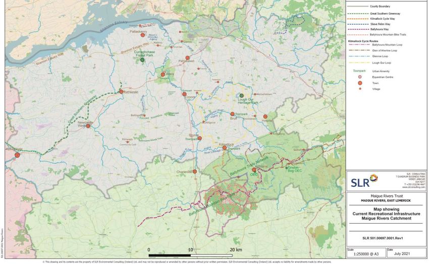
Exploration of Recreation & Amenity Potential of Maigue Rivers                             SLR 501.00697.00001 R2 v1
Maigue Rivers Trust: Phase 2 Development Opportunities                                                     July 2021

    © Maigue Rivers Trust, 2021

    ISBN: 978-1-9161760-6-5

    Recommended reference: Maigue Rivers Trust (2021)

    An Exploration of Recreation & Amenity Potential of Maigue Rivers. Maigue Rivers Trust, Ireland..

.
Exploration of Recreation & Amenity Potential of Maigue Rivers                                                                                             SLR 501.00697.00001 R2 v1
Maigue Rivers Trust: Phase 2 Development Opportunities                                                                                                                     July 2021

    CONTENTS
             INTRODUCTION ................................................................................................................. 1
     1.1     The Maigue Rivers Trust ...............................................................................................................1
     1.2     Terms of Reference ......................................................................................................................2
     1.3     Methodology ................................................................................................................................3
     1.3.1   Policy & Strategy Context ............................................................................................................................................. 3
     1.3.2   Desk Research ............................................................................................................................................................... 3
     1.3.3   Mapping ........................................................................................................................................................................ 4
     1.3.4   Stakeholder Consultations ............................................................................................................................................ 4
     1.3.5   International Models of Riverine Recreation ............................................................................................................... 4
     1.3.6   Citizen Science .............................................................................................................................................................. 5
     1.3.7   Analysis and Conceptualisation .................................................................................................................................... 5
     1.3.8   Development Options................................................................................................................................................... 5

     1.4     What is Recreation? .....................................................................................................................5

             SUMMARY OF PHASE 1 REPORT: MAIGUE RIVERS ............................................................. 7
     2.1     Natural Environment of Maigue Rivers ........................................................................................7
     2.2     The Cultural Environment of the Maigue Rivers ....................................................................... 10
     2.2.1   Demographics of Co. Limerick .................................................................................................................................... 10
     2.2.2   Cultural Heritage ......................................................................................................................................................... 11

     2.3     Current Recreational Provision in the Maigue Rivers Catchment ............................................ 13
     2.3.1   Baseline Survey of Current Recreation Infrastructure ............................................................................................... 13
     2.3.2   Current Usage of Recreational Amenities .................................................................................................................. 13
     2.3.3   SCOT Analysis .............................................................................................................................................................. 13

             PROPOSALS FOR DEVELOPMENT ..................................................................................... 18
     3.1     Recreation and Public Health .................................................................................................... 20
     3.2     Recreational ‘Gateway’ Infrastructure ...................................................................................... 21
     3.3     Proposals for Walking Amenities .............................................................................................. 23
     3.3.1   Walking Infrastructure ................................................................................................................................................ 23
     3.3.2   Optimisation of Town Parks Network......................................................................................................................... 30

     3.4     Proposals for Cycling Amenities ................................................................................................ 33
     3.5     Proposals for Boating Development ......................................................................................... 39
     3.5.1   Boating Constraints .................................................................................................................................................... 39
     3.5.2   Boating Opportunities ................................................................................................................................................ 39
     3.5.3   Biosecurity & Invasive Species control ....................................................................................................................... 40

.
Exploration of Recreation & Amenity Potential of Maigue Rivers                                                                                           SLR 501.00697.00001 R2 v1
Maigue Rivers Trust: Phase 2 Development Opportunities                                                                                                                   July 2021

     3.5.4    Proposals for Boating Infrastructure .......................................................................................................................... 40
     3.5.5    Kayaking/ Small Vessel Trail Opportunities ................................................................................................................ 45
     3.5.6    Activity Zone in Croom on the Maigue ....................................................................................................................... 47
     3.5.7    Proposals for On-Water Activities .............................................................................................................................. 47

     3.6     Proposals for Angling Development .......................................................................................... 55
     3.6.1    Current Status of Angling............................................................................................................................................ 55
     3.6.2    Habitat Restoration & Conservation .......................................................................................................................... 57
     3.6.3    Angling Rehabilitation ................................................................................................................................................. 57
     3.6.4    Proposals for Angling Development ........................................................................................................................... 58

     3.7     Proposals for Nature & Wildlife Observation ........................................................................... 60
     3.7.1    Proposals for Nature Viewing ..................................................................................................................................... 60
     3.7.2    Proposals for Outdoor Education ............................................................................................................................... 62
     3.7.3    Citizen Science Engagement ....................................................................................................................................... 63
     3.7.4    Other Nature-based Activities .................................................................................................................................... 65
     3.7.5    Proposals for Nature Viewing & Observation ............................................................................................................ 66

     3.8     Proposals for Other Actions ...................................................................................................... 73
     3.8.1    Festivals & Events ....................................................................................................................................................... 73
     3.8.2    Calendar of Events ...................................................................................................................................................... 73
     3.8.3    Environmental Summer School .................................................................................................................................. 74
     3.8.4    Creative Events ........................................................................................................................................................... 74
     3.8.5    Proposals for Other Opportunities ............................................................................................................................. 74

     3.9     Promotion of Recreation along the Maigue Rivers ................................................................... 76

             SUMMARY OF PROPOSALS FOR MAIGUE RIVERS CATCHMENT ........................................ 77

             POTENTIAL SOURCES OF FUNDING .................................................................................. 84

    DOCUMENT REFERENCES

    TABLES
    Table 1 Types of Outdoor Recreation .................................................................................................. 6
    Table 2 Estimate of Current Recreational Usage ............................................................................... 16
    Table 3 SCOT Analysis – Maigue Rivers Recreation & Amenity ......................................................... 17
    Table 4 Sample Calendar of Events, Maigue Rivers ........................................................................... 74
    Table 5 Conceptual Proposals: Recreation & Amenity, Maigue Rivers .............................................. 78
    Table 6 Potential Sources of Funding for Implementation ................................................................ 84

.
Exploration of Recreation & Amenity Potential of Maigue Rivers SLR 501.00697.00001 R2 v1
Maigue Rivers Trust: Phase 2 Development Opportunities July 2021
FIGURES
Figure 1 Maigue Rivers – Methodology Adopted................................................................................. 3
Figure 2 Map of Maigue Rivers Catchment .......................................................................................... 7
Figure 3 EPA Water Quality in Rivers (2019) -Nutrient Quality ............................................................ 9
Figure 4 Limerick City & County: Settlement Strategy ....................................................................... 10
Figure 5 Demographic Profile, Co. Limerick (CSO 2016) ................................................................... 11
Figure 6 Map showing Current Recreation, Amenity & Service Provision, County Limerick ............. 14
Figure 7 Map showing current Recreational Infrastructure, Maigue Rivers & hinterlands ............... 15
Figure 8 Map showing Proposals for Recreation & Amenity - Maigue Rivers Catchment ................ 19
Figure 9 Proposed Trail along The Bank, Maigue Estuary .................................................................. 25
Figure 10 Proposed eastern extension to Great Southern Greenway ............................................... 27
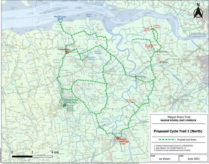
Figure 11 Proposed Cycle Trail 1 (North) ........................................................................................... 36
Figure 12 Proposed Cycle Trail 2 (MID) .............................................................................................. 38
Figure 13 Key considerations for design of Water-based Trails (from Sport Ireland) ........................ 46
Figure 14 Map showing proposed Maigue Rivers Kayak Trails .......................................................... 50
Figure 15 Map of Combined Current and Proposed Recreational Infrastructure, Maigue Rivers ..... 78
APPENDICES
Appendix 01: Terms of Reference
ANNEXES
Annex 1: Phase 1 Baseline Report in pdf format
.
Exploration of Recreation & Amenity Potential of Maigue Rivers                         SLR 501.00697.00001 R2 v1
 Maigue Rivers Trust: Phase 2 Development Opportunities                                                 July 2021

          Introduction
The Maigue Rivers Trust commissioned SLR Consulting to undertake an Exploration of
the Recreation and Amenity Potential of the Maigue Rivers in County Limerick. This final
report presents development opportunities identified in Phase 2 of the study across five
key recreation types and related amenities, with recommendations derived from
baseline research, field mapping and consultations with a wide range of stakeholders.

SLR Environmental Consulting (Ireland) Limited (SLR Consulting/ SLR) was appointed by the Maigue Rivers Trust
to undertake an Exploration of the Recreation and Amenity Potential of the Maigue Rivers in County Limerick, in
December 2020. The Maigue Rivers include the Maigue, Barnakyle, Clonshire, Camoge, Morningstar and
Loobagh Rivers, as well as their smaller tributaries. This report presents the findings of the second and final
phase of the study to identify recreational development opportunities across the catchments, focused on
interaction with and /or use of the rivers and their environs.

1.1       The Maigue Rivers Trust
Rivers Trusts are charities, established by local people, to protect and improve rivers, streams and lakes in a
particular river-catchment or an area comprising many river catchments.

The Maigue Rivers Trust (MRT) www.maigueriverstrust.org was established in 2016 to protect, enhance and
promote the use and enjoyment of the rivers of the Maigue catchment. Central among its objectives are to:
    ✓   Create awareness through education programmes, outdoor classrooms and school visits.
    ✓   Encourage community participation by developing networks of interest groups to input to the Trust’s
        action plans and to get involved in helping enhance the river.
    ✓   Improve water quality by working with sectoral interests to minimise impacts.
    ✓   Improve fish habitat and fish numbers by carrying out in-stream works, to better understand current
        fish stocks and seeking funding for research and fishery management initiatives.
    ✓   Protect biodiversity by improving habitat for otter, kingfishers and other species and carrying out
        catchment wide biodiversity assessments.
    ✓   Control invasive plants such as Giant Hogweed, Japanese Knotweed and Himalayan Balsam which can
        seriously affect the biodiversity and amenity value of a river corridor.
    ✓   Encourage the local angling tradition by supporting juvenile angling programmes and competition and
        by supporting angling clubs in the catchment.
    ✓   Develop amenity access to the river for recreational activities such as walking, kayaking, etc.

The Trust is part of an all-islands network of established rivers trusts in Northern Ireland, England and Wales,
and rivers and fisheries trusts in Scotland, linking a wealth of knowledge and expertise in river conservation and
management. The Department of Environment, Climate and Communications (DECC) and the Local Authority
Water and Communities Office (LAWCO) support the rivers trusts across Ireland (the umbrella body for rivers
trusts www.theriverstrust.org) with the appointment of an all-island Ireland Development Officer. An integrated
programme of water management activities (LAWPRO) is carried out by Local Authorities in Ireland to meet the
requirements of the EU Water Framework Directive.

The MRT liaised with LAWPRO through the Irish Rivers Trust Resilience Pilot Project to appoint a development
officer, to coordinate and apply best practice to the Maigue catchment programmes. The Resilience Pilot Project

                                                          Page 1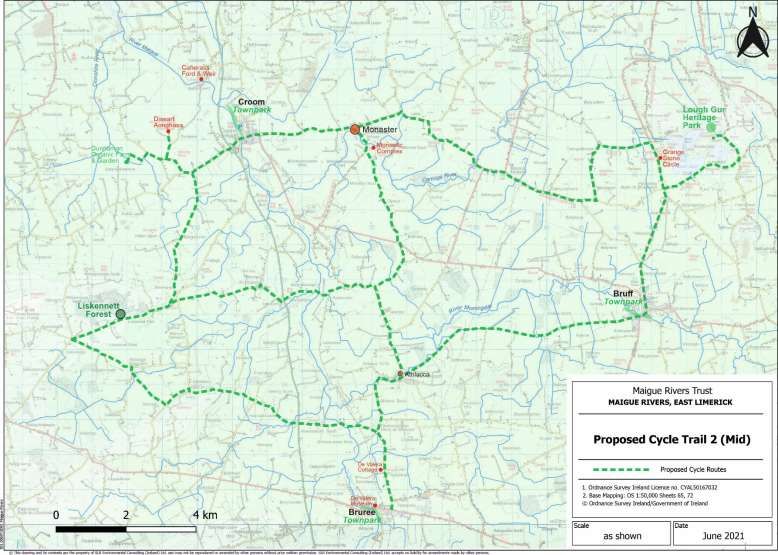
Exploration of Recreation & Amenity Potential of Maigue Rivers                            SLR 501.00697.00001 R2 v1
 Maigue Rivers Trust: Phase 2 Development Opportunities                                                    July 2021

is funded through the LAWPRO by the Department for Housing, Local Government and Heritage and is managed
by The Rivers Trust.

A key objective of the Trust is to encourage public appreciation of the river environment by promoting its value
for recreation and amenity purposes. It is in this context that the study to explore the recreation and amenity
potential of the Maigue catchments was commissioned.

1.2       Terms of Reference
The following outlines a summary of the scope of work and objectives as set out in the terms of reference by
MRT (see Appendix 1 for full terms of reference).
The aim of this project is to conduct a river recreation and amenity survey that will document river focussed
facilities and services, address information gaps, and prescribe a range of potential developments that are likely
to be effective. The study is required to collate focussed baseline information on the structure and composition
of recreation and amenity provision in the Maigue catchment, and identify potential for developing recreational
and leisure activities on and around the rivers in the Maigue catchment.
This will provide required data for the future management of the development in/near the catchment rivers for
the benefit of biodiversity, water quality and recreational and other uses by local communities and visitors.
The core objective of this project is to identify a suite of recreational and amenity facilities, focused primarily on
walking, cycling, boating, angling and nature/ wildlife observation.
This will include two key phases, with defined deliverables, as follows:

    1. Analysis of the current usage of the Maigue Rivers for outdoor recreation and amenity

        Deliverable 1: a document and presentation detailing the current recreation and amenity provision (and
        condition) for walking, cycling, boating, angling and nature and wildlife observation.

    2. Identification of the potential for developing recreational and leisure activities on and around the
       rivers in the Maigue catchment

         Deliverable 2: a document and presentation that outlines development possibilities in the above
         categories in order to encourage the interaction with and/or use of the river and/or river environs.

The early Phase 1 desk-based research and consultation stages of the project were undertaken during national
Level 5 pandemic ‘lock-down’, which prohibited conduct of field work for most of the first four months of 2021.
In the latter months, intensive field work and practical assessments were undertaken to test / enhance the
concepts identified in the Phase 1 Baseline Report.
The results of the Phase 2 work are presented in the following chapters.

                                                          Page 2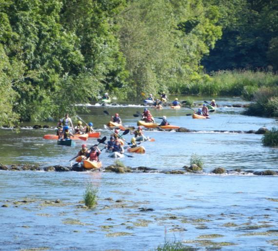
Exploration of Recreation & Amenity Potential of Maigue Rivers                       SLR 501.00697.00001 R2 v1
 Maigue Rivers Trust: Phase 2 Development Opportunities                                               July 2021

1.3       Methodology
The methodology adopted throughout the project reflected the peculiar circumstances of the global covid
pandemic which necessitated national restrictions on travel and physical communications through 2020 to
Q1/2021.
This prevented inter-county travel and any form of communal meetings/ workshops or internal gatherings during
the project duration. Thus, planned consultations were largely undertaken electronically and face-to-face
meetings were confined to outdoor meetings in the latter stages of the project.
The following phased methodology was adopted (Figure 1):

                                  Figure 1 Maigue Rivers – Methodology Adopted

                             Desk
                           Research        Mapping        Review
            Policy &                                      of Best    Analysis &      Reporting &
            Strategy        Envir &        & Field
                                           Surveys        Practice   Concepts     Recommendations
            Review          Cultural                      Models
                            Setting

                                        Stakeholder
                                       Consultations

1.3.1     Policy & Strategy Context
In Phase 1, a full review of European, national, regional and county policies regarding recreation, tourism and
public health was undertaken:
    •   Review of planning, recreational infrastructure, tourism and biodiversity policies and strategies at EU,
        national, regional, county and local level;
    •   Review of Irish and international best practice and options for recreational management;
    •   Review of local development plans, policies and commitments.
A full summary of the review is presented in Appendix 2 of the final Phase 1 report (attached as Annexe 1).

1.3.2     Desk Research
Data gathering through extensive desk research was undertaken to identify the current provision for recreation
in the Maigue Rivers catchment, including the Maigue, Loobagh, Morningstar, Camoge, Clonshire and Barnakyle
rivers, including inter alia the Mahore, Flemingstown (Nóinín) and Greanagh streams in the catchment. This area
drains the eastern portion of County Limerick from the Ballyhoura Mountains in the south, northwards to the
Shannon Estuary.

                                                          Page 3
Exploration of Recreation & Amenity Potential of Maigue Rivers                          SLR 501.00697.00001 R2 v1
 Maigue Rivers Trust: Phase 2 Development Opportunities                                                  July 2021

This research looked at the geographical, geological, environmental and cultural setting of the Maigue Rivers to
ensure these factors informed the analysis.
There are very few detailed Maigue-specific data available in terms of recreational usage of the rivers, apart from
anecdotal data gathered through the consultations. Thus, an assessment was made of the demographic profile
of County Limerick and future likely demand for recreational amenities.
The Phase 1 data gathering phase was supplemented in Phase 2 by field checking and verification, where
possible, through discussions with stakeholders and site observations.

1.3.3     Mapping
In Phase 1, desk-based mapping was undertaken of a range of natural and cultural heritage features:
    •   Mapping of geographical, geological and landscape features;
    •   Designated natural heritage sites, including SACs, SPAs, NHAs and nature reserves.
    •   Digital mapping of all known recreational and amenity facilities in the Maigue Rivers catchments,
        including activity trails, heritage sites and amenities;
    •   Digital mapping of amenities and services, as well as recording of contact details and digital presence.
In Phase 2, desk mapping was supplemented by field visits, to photograph features and assess in particular, key
aspects of physical access and viability of some of the earlier identified options. Field surveying was carried out
along the length of the Maigue and its tributaries, travelling along each of the rivers, noting bridges/ crossings;
access points where available; natural and cultural heritage features; potential constraints, public safety issues
and identification of opportunities for enhanced public enjoyment of the rivers.
A series of maps were prepared of the identified options to demonstrate the recreational potential of this region.

1.3.4     Stakeholder Consultations
In Phase 1, a comprehensive list of potential stakeholders was drawn up and consultations were held with a wide
range of stakeholders. This included:
    •   Stakeholders in the Maigue Rivers catchment for recreation, amenity, landowners and land managers,
        amenity managers, local development officers, NGOs, active retirement groups, recreational users and
        clubs (walking, cycling, kayaking, rowing, astronomy, birdwatching, angling etc);
    •   Review of demographics and population profile of County Limerick, and assessment as to how it might
        influence recreational planning.
    •   Attendance at a number of related online workshops, including LAWPRO water management workshops;
        Lough Gur archaeo-astronomy workshop; Shannon Estuary Way communications and national EIP agri-
        environmental online meetings, all of which were relevant to the study.
Consultations and interviews were held mainly by telephone/zoom calls, with limited Phase 2 face-to-face
outdoor meetings held in the later stages of the project.

1.3.5     International Models of Riverine Recreation
The Phase 1 report presented a short review of best practice for riverine recreational models and management.
Northern Ireland, the UK and USA present some pointers, but given land ownership patterns and management
models in Ireland that differ from other jurisdictions, it is clear that new models may need to evolve here to
integrate the recreational opportunities for on-water and beside-water amenities.
The key challenge, particularly for the Maigue Rivers, is creating safe, public access to our riverine environments
both on- and off-water, without compromising the rights of landowners.

                                                          Page 4
Exploration of Recreation & Amenity Potential of Maigue Rivers SLR 501.00697.00001 R2 v1
Maigue Rivers Trust: Phase 2 Development Opportunities July 2021
1.3.6 Citizen Science
A short review of Citizen Science measures was conducted and a range of relevant initiatives in Ireland were
identified through consultations with practitioners in Citizen Science initiatives.
There is considerable scope to harness public interest in engaging with citizen science as evidenced by the recent
Maigue Rivers Trust participation in the international freshwater Water Blitz1 and other initiatives.
1.3.7 Analysis and Conceptualisation
Following Phase 1, an early analysis of the data was carried out and a SCOT matrix developed to identify
strengths, challenges, gaps and possible opportunities for development.
This allowed the identification and mapping of conceptual recreation and amenity opportunities for presentation
to the Board of MRT. The results of Phase 1 work were presented to the Board at the end of March 2021.
The Board provided written feedback and comments on the Draft Phase 1 report. These comments were
included in the final report, attached as Annex 1 to this report.
1.3.8 Development Options
Following Phase 1, it was clear that the Board wished to focus on the river environment itself and enhanced
recreational amentities along or beside the rivers. Thus the focus in Phase 2 has been to identify enhanced
opportunities to access beside- and on-the-water activities, with particular reference to the lowland catchment
of the Rivers.
The Board also acknowledges the role that wider ‘honeypot’ amenities such as Curraghchase and Lough Gur play
in attracting both Limerick residents and visitors to this part of county Limerick.
Given the critical access constraints identifed, the network of attractive Town Parks in the catchments provide
vital and safe public access to the rivers, while also allowing recreational activities and nature viewing
opportunities.
Details of the Phase 2 conclusions and recommendations are presented in the following chapters.
1.4 What is Recreation?
It is useful to define the concept of ‘Recreation’ at the outset to provide a clear focus for the Maigue Rivers study.
A useful definition was provided by the National Countryside Recreation Strategy2, but this is currently (June 2021)
being redeveloped under the auspices of Comhairle na Tuaithe as the National Outdoor Recreation Strategy
and, based on current online public consultation information3, provides a clear definition as follows:
‘Outdoor recreation’…means activities that take place in the natural environment, such as walking,
canoeing, mountain biking, orienteering and wild swimming. It does not include activities that take place
outdoors on confined courses or pitches (such as golf, football, show jumping) nor motorised activities
(such as quads)’.
Thus, outdoor recreation may be seen to include the following types of activities (Table 1):
______________________
1
WaterBlitz | FreshWater Watch (thewaterhub.org)
2
www.gov.ie/en/policy-information/127c4b-national-countryside-recreation-strategy/
3
https://www.gov.ie/en/consultation/42e3a-public-consultation-on-a-national-strategy-on-outdoor-
recreation/#:~:text=The%20strategy%20will%20provide%20a,in%20Ireland's%20outdoor%20recreation%20sector.
Page 5Exploration of Recreation & Amenity Potential of Maigue Rivers SLR 501.00697.00001 R2 v1
Maigue Rivers Trust: Phase 2 Development Opportunities July 2021
Table 1 Types of Outdoor Recreation
Land-Based Water-Based Air-Based
Walking Angling Para-gliding
Hiking/ Hillwalking Canoeing/ Kayaking Hang-gliding
Leisure Cycling Rowing
Mountain Biking Wild swimming
Horseriding Surfing
Trail/ Off-trail running Coasteering
Orienteering Windsurfing. Kite-surfing
Bouldering, Scrambling Sailing
Rock climbing Diving
Mountaineering
Caving
(from public consultation documentation on National Outdoor Recreation Strategy (2021))
Across Europe, the terms ‘Green’ and ‘Blue’ infrastructure are commonly used to describe natural and semi-
natural areas and features (land, vegetation and waterways) in public or private, rural, urban and peri-urban
areas that deliver a broad range of eco-system services (water and air quality, biodiversity) that underpin a
healthy environment, including spaces for recreation and amenity4.
In Ireland, in discussing outdoor recreational infrastructure, ‘green’ typically refers to land-based activities
(walking, cycling, hiking, nature viewing) and ‘blue’ refers to water based activities (kayaking, canoeing,
swimming, boating, angling etc), and at best where green and blue infrastructure align as in ‘blueways’.
Based on these definitions, the five key areas of recreation set out in the terms of reference (walking, cycling,
boating, angling and nature/ wildlife observation) were considered, including related aspects to enhance amenity
value.
Although recreational tourism opportunities were not specifically identified in the terms of reference, the
recently published national strategy for rural development ‘Our Rural Future, 2021 - 20255’ (DRCD, 2021) sees
outdoor recreation as an increasing driver of rural tourism with a key role to play in sustaining both rural
communities and enterprises. Vibrant communities with opportunities to enjoy outdoor activities also provide
attractive destinations for rural tourism.
______________________
4
https://ec.europa.eu/environment/nature/ecosystems/benefits/index_en.htm
5
https://www.gov.ie/en/publication/4c236-our-rural-future-vision-and-policy-context/
Page 6Exploration of Recreation & Amenity Potential of Maigue Rivers SLR 501.00697.00001 R2 v1
Maigue Rivers Trust: Phase 2 Development Opportunities July 2021
Summary of Phase 1 Report: Maigue Rivers
This section summarises key elements of the Phase 1 Baseline Report on the natural and
cultural setting of the river catchments, as well as existing recreational provision in the
area. The reader is referred to Annex 1 of this report for full details.
2.1 Natural Environment of Maigue Rivers
The River Maigue and its principal tributaries, the rivers Loobagh, Morningstar, Clonshire, Barnakyle and Camoge,
encompass a land area of 1000 km2 and include 1300 km of river channel, mainly in Co. Limerick. The river
displays a classic dendritic drainage pattern as it crosses the lowlands of East Limerick (Figure 2).
Figure 2 Map of Maigue Rivers Catchment
Dooradoyle
The rivers Maigue and Loobagh rise in the Mullaghareirk and Ballyhoura Mountains to the south and southeast
of County Limerick and drain northwards to the Shannon Estuary. The Morningstar and Camoge Rivers rise in
the Galtees and Slieve Felim Mountains respectively, while the Clonshire rises in the hills at Knockfierna and the
Barnakyle at Fedamore respectively.
The landscape of Limerick is largely sculpted by glacial activity, comprising rich pastoral lowlands with rolling
hills, lakes, rivers, fens and woodlands. The Maigue Rivers are mainly situated in glacially derived soils that
support diverse ecology and species-rich habitats, including fields and hedgerows, riparian zones alongside small
lakes and rivers, as well as estuarine wetlands. The Maigue catchment lakes, including Gur, Bleach, Glasha and
Page 7Exploration of Recreation & Amenity Potential of Maigue Rivers SLR 501.00697.00001 R2 v1
Maigue Rivers Trust: Phase 2 Development Opportunities July 2021
Dromore Loughs respectively, are popular for angling, boating and a limited number of water sports, as well as
for their amenity value and beauty.
East County Limerick is well served by national roads infrastructure. It is traversed by major national arterial
routes, including the Limerick-Tralee/Killarney M20-N21; the Limerick-Cork N20 (planned to be upgraded to
motorway M20), as well as the east-west scenic Shannon Estuary Way (N69), an extension of the Wild Atlantic
Way. The N24 feeds north-westwards from Waterford-Tipperary to Limerick City in the eastern part of the
county and catchment. A network of regional roads (R511, R512, R513, R516, R518) connect the main towns
and settlements in the catchment areas of the Maigue Rivers.
The landmark ‘rail-to-trail’ Great Southern & Western Greenway currently runs from Rathkeale to Abbeyfeale. It
is planned to extend it from Rathkeale westwards to Listowel and ultimately Tralee, with the feasibility of an
eastern extension from Rathkeale to Adare and ultimately Limerick City being examined.
East Limerick is traditionally a landscape of intensive agriculture within the rich farmlands of the Golden Vale. It
is associated with dairying, pork and equine production in the lowlands and sheep farming in the uplands. There
is a strengthening organic and slow food movement within the region, with a number of flagship producers and
food markets emerging, including the weekly Farmers Markets and Urban Cooperatives.
A fuller description of the unique aspects of the geology, landscape character, ecology, habitats and water quality
is presented in Chapter 2 of the Phase 1 baseline report (Annex 1).
These natural characteristics inform the proposals contained within the current Phase 2 report.
As well as providing healthy habitats for fish and other river life, good water quality is
essential to the development of recreation along the Maigue Rivers catchment – whether
for angling, kayaking, walking or swimming – for all to enjoy!
Under the EU Water Framework Directive (WFD), the Maigue is part of the ‘Shannon International River Basin
District’, and managed under its River Basin Management Plan. The EPA undertakes a full national assessment
every three years, using ten physical, biological and chemical indicators, to measure surface water quality in
Ireland. The most recent report on surface water quality was published by the EPA in late 20206 which indicates
that 47% of Ireland’s river sites have unsatisfactory nitrate concentrations.
• Phosphate, shows higher concentrations in the east and northeast of Ireland, but also in the Shannon
Estuary South catchment, including the Maigue (see Figure 3a);
• Nitrate concentrations are highest in rivers in the south/ southeast of Ireland where there is more
intensive farming, coupled with freely draining soils and lower rainfall (see Figure 3b).
The EPA findings were not encouraging for the River Maigue catchment. Nutrient pollution (nitrogen and
phosphorus) from intensive grass-based agriculture and wastewater treatment is the predominant pressure on
water quality in the catchment. Of 33 locations sampled in 2017/18, 24 were unchanged from the previous
sampling; two were improved slightly, and seven had deteriorated. Nearly all of the deterioration was in the
Maigue, Mahore and Morningstar rivers.
Some rivers are at risk of not achieving the required standard of water quality under the Water Framework
Directive. One of these, the River Camoge, has been designated as a priority Action Area with measures to
improve water quality. The MRT has a number of projects underway to address water quality in the Maigue
Catchments, inter alia at West Liskennett; Drumcamogue and citizen science projects, working with farmers,
LCCC, LAWPRO and IFI to improve the habitat for salmon, trout and other river life.
______________________
6
http://epa.ie/pubs/reports/water/waterqua/Water%20Quality%20in%202019%20-%20an%20indicators%20report.pdf
Page 8Exploration of Recreation & Amenity Potential of Maigue Rivers SLR 501.00697.00001 R2 v1
Maigue Rivers Trust: Phase 2 Development Opportunities July 2021
Figure 3 EPA Water Quality in Rivers (2019) -Nutrient Quality
Figure 3a. River Phosphate Quality for 2019 (EPA 2020)
Figure 3b. River Nitrate Quality for 2019 (EPA, 2020)
Page 9Exploration of Recreation & Amenity Potential of Maigue Rivers SLR 501.00697.00001 R2 v1
Maigue Rivers Trust: Phase 2 Development Opportunities July 2021
2.2 The Cultural Environment of the Maigue Rivers
The cultural environment and setting of the Maigue Rivers was presented in some detail in the Phase 1 baseline
report (Annex 1). This section provides a summary of key points.
2.2.1 Demographics of Co. Limerick
Limerick City and County Council has just published its first combined City-County Development Plan (2022-
2028). The council proposes a hierarchy of towns to allocate resources and priorities according to servicing,
transport and demographic requirements. In this framework, the Tier 2 town of Kilmallock is the key settlement
for east Limerick, while the Tier 3 towns of Adare, Patrickswell and Croom are located on transport nodes. All
other settlements are classified as villages or small villages, within a largely rural setting (Figure 4).
Figure 4 Limerick City & County: Settlement Strategy
The settlement patterns, demographics and age profile of County Limerick were considered in Phase 1.
Based on the most recent (2016) census data, the total population of the county (ex-city) was just under 195,000
people. Of these, 15% are living with a disability. The population demonstrates a classic ‘bell curve’, with a midlife
(30-69 years) demographic bulge, while the under-5 year cohort is less than the under-12, or under-19 groups
(Figure 5).
Page 10Exploration of Recreation & Amenity Potential of Maigue Rivers SLR 501.00697.00001 R2 v1
Maigue Rivers Trust: Phase 2 Development Opportunities July 2021
Figure 5 Demographic Profile, Co. Limerick (CSO 2016)
16000
14000
12000
10000
8000
6000
4000
2000
0
U-5 U-12 U-19 U-29 U-39 U-49 U-59 U-69 U-79 U-84 85+
Male Female
Demographic Observations:
• The large midlife demographic will be moving into retirement and will likely make significant demands
for outdoor recreational amenities, based on recent national and international trends. These trends
have been accentuated during the covid period, as people ‘discovered’ what was on their own doorsteps.
• The data suggest that the general population is in good health and will likely seek increasing
opportunities for recreation to remain so as the population ages.
• The general population of county Limerick is highly educated, with more than 65% reporting a higher
level qualification.
• In relation to transport, the CSO data show that most people rely on the motor car to get to work/ school
and college, reflecting the lack of integrated public transport in rural areas to get to employment or
college in the City area, and the lack of safety for walking or cycling to work or school on busy commuter
routes. The majority of people commute less than 45 minutes to work, school or college (84%).
2.2.2 Cultural Heritage
East County Limerick enjoys a rich heritage from archaeological times to the present, which was presented in
summary in the Phase 1 report. The region is host to a huge array of archaeological sites and monuments, as
well as an extraordinarily rich medieval heritage.
The Lough Gur archaeological complex7, including Grange Stone Circle, is an internationally important heritage
site, within an extraordinary array of prehistoric monuments and settlement features8.
Later structures were built in the vicinity of Lough Gur through the early Christian and later medieval periods.
The Lough Gur complex was used for ritual purposes and ongoing research is investigating the potential for an
International Dark Skies Park to celebrate the rich evidence of archaeo-astronomical understanding of seasonal
celestial activities throughout the archaeological landscape.
The environmental history of East Limerick is recorded in the Lough Gur’s lake sediments, where pollen samples
record an actively changing biota since prehistoric times, reminding us that climate change is constant (see
Section 3.1 below also).
______________________
7
Lough Gur encompasses a complex archaeological site within an area rich in prehistoric monuments, that includes
enclosures, stone circles, standing stones, hut sites, cairns, banks, pit burials, crannogs and other settlement features dating
from the Neolithic period but also encloses features that range through the Beaker and Bronze age burial sites.
8
See: National Monuments Service: https://maps.archaeology.ie/HistoricEnvironment/
Page 11Exploration of Recreation & Amenity Potential of Maigue Rivers SLR 501.00697.00001 R2 v1
Maigue Rivers Trust: Phase 2 Development Opportunities July 2021
Elsewhere across the Maigue Catchments, there are multiple archaeological features and clusters of enclosures
and ring barrows (Stephenstown, Elton, Mitchelstowndown West); ringforts (Greenmount, Crecora);
souterrains, cists, ringforts and raths (Cush); fulacht fia (Ballycahane); and an innumerable array of archaeological
features preserved in the rich pastoral lands of the Maigue catchments.
The early medieval period in East Limerick saw a number of early Christian sites developing (Dysert Aonghusa),
with churches, graveyards and holy wells, many of which became important centres of monasticism and learning
in the later medieval period (Adare, Monaster).
Dysert Aonghusa at Carrigeen, Croom, Co Limerick
A key feature of County Limerick is its fine heritage of Medieval towns and castles, with associated infrastructure
of walls, bridges. The walled town of Kilmallock on the Loobagh River, displays merchants’ houses, collegiate
churches and wall gates, with a fine walk along the River Loobagh to the Franciscan Friary (Priory Walk) and along
the restored Town Walls. At Ballingarry, there is the ruin of the Norman De Lacy castle in the upper Clonshire
(Finshenagh) catchment, as well as Bruree Castle at Lotteragh Upper on the Maigue.
There are many tower houses and castles (Castleroberts) dotted across the landscape of East Limerick, frequently
in defensive sites close to river crossings, as well as medieval corn mills on many of the smaller rivers in the
Maigue catchment (Beabus/ Derryvinnane on the Clonshire) as well as at Croom on the Maigue. Medieval
bridges survive (e.g. Bruff, Castleroberts, Adare, Kilmallock) and provide vital crossing points to this day.
Thus, there is a range of highly significant cultural heritage features that may be included in experiential
recreational trails within the county.
Page 12Exploration of Recreation & Amenity Potential of Maigue Rivers SLR 501.00697.00001 R2 v1
Maigue Rivers Trust: Phase 2 Development Opportunities July 2021
2.3 Current Recreational Provision in the Maigue Rivers Catchment
A detailed survey of current outdoor recreational provision in the Maigue catchment was
undertaken in Phase 1, which is appended as Annex 1 of this report. An outline summary
and SCOT analysis is presented in this section.
2.3.1 Baseline Survey of Current Recreation Infrastructure
An initial survey was conducted in Phase 1 of the full range of recreation available in County Limerick, as well as
amenities, heritage centres and service providers (accommodation, food, guides, etc). A spatial presentation of
the data is shown on the map in Figure 6 overleaf.
The Phase 1 Baseline Report presented an analysis of the current recreational provision within the defined
categories of:
• Walking
• Cycling
• Boating
• Angling
• Nature Viewing
• Other Recreation, and
• Heritage
A map showing current recreational provision is presented in Figure 7 overleaf.
There is a very significant baseline array of amenities and services available. As outlined in recent studies9, the
challenge lies in the integration of these services and products to develop an outdoor destination of scale.
The reader is referred to Annex 1 for the full Phase 1 analysis.
2.3.2 Current Usage of Recreational Amenities
There are very limited data available on actual usage of these amenities in Co. Limerick at large, although
Ballyhoura Country are working to achieve improved monitoring of visitor numbers and usage through
emplacement of trail counters at key points along the Ballyhoura trails network and as part of the greater Beara
Breifne Way initiative.
There are limited counters at access points to outdoor recreational amenities throughout the Maigue Rivers
catchment, and it is currently impossible to enumerate quantitatively, with confidence, exactly how many people
use these facilities. Based on formal conversations with recreational amenity managers at Curraghchase and
Lough Gur, and informal conversations held with recreational users, during the consultation phase of this project
(albeit possibly distorted by covid local restrictions), the rivers are used to a mixed degree recreationally, with
most local usage by walkers in defined amenities (parks and forests) – see Table 2 below.
2.3.3 SCOT Analysis
As part of the Phase 1 review of the recreational amenities of the Maigue catchments, a Strengths, Challenges,
Opportunities and Threats (SCOT) analysis was carried out. The results are presented below in Table 3.
______________________
9
e.g. Ballyhoura Country – The Way Forwards (2020) recommends a strategic approach to “Increasing Collaboration,
Partnership & Buy-in” to developing the destination.
Page 13Exploration of Recreation & Amenity Potential of Maigue Rivers SLR 501.00697.00001 R2 v1
Maigue Rivers Trust: Phase 2 Development Opportunities July 2021
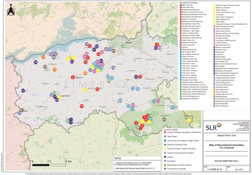
Figure 6 Map showing Current Recreation, Amenity & Service Provision, County Limerick
Page 14Exploration of Recreation & Amenity Potential of Maigue Rivers SLR 501.00697.00001 R2 v1
Maigue Rivers Trust: Phase 2 Development Opportunities July 2021
Figure 7 Map showing current Recreational Infrastructure, Maigue Rivers & hinterlands
Page 15Exploration of Recreation & Amenity Potential of Maigue Rivers SLR 501.00697.00001 R2 v1
Maigue Rivers Trust: Phase 2 Development Opportunities July 2021
Table 2 Estimate of Current Recreational Usage
Activity Estimates of Recreational Usage from Consultative Reports
Walking • Curraghchase Forest Park receives up to 80,000 visitors per annum, but this is likely an
under-estimation as many local users access the site from different entrances.
• Lough Gur Heritage Park had more visitors in January 2021 than during normal summer peak
periods, due to the increase in people using the facilities during covid lockdown.
• The River Walk at Adare had to be directed as ‘one-way-traffic’ during the covid period due
to numbers of people using it, reflecting the demand for walking access.
• Croom Town Park enjoys high usage for Maigue riverside recreation; not enumerated.
• Kilmallock walkers enjoy the Loobagh riverside Priory Walk and Town Walls Walk of c. 5km.
• Local walkers at Ardpatrick in the Flemingstown (Noinín)/Loobagh catchment enjoy walks of
5km on a daily basis to and from the monastic site, along a waymarked track.
• Walking Clubs located in the catchment seek longer half-day to full-day walks in the
Ballyhoura and Mullaghareirk Mountains.
• Active Retirement groups enjoy walks of 5-6km, followed by a social gathering at a café/hotel
for coffee and chat, at locations such as Adare or Curraghchase; seeking new offroad options.
• Liskennett Forest well used for walking; over-subscribed; concerns for traffic, parking, safety.
• Ballinruane Woods, Kilmeedy and Knockainy Hill - enjoy high local usage; not enumerated
Cycling • No estimate available of numbers of cyclists using the Great Southern Greenway
• Significant numbers of Cyclists, particularly groups of men, use the intricate network of small
link roads throughout the county to explore the countryside.
• Family groups enjoy cycling at Curraghchase.
Boating • Limited use of the rivers for boating, although community group in Adare is trying to restore
the old Turf Quay to create a safe landing place for boating on the tidal section of Maigue.
• Maigue Rowing Club at Ferrybridge is revitalising traditional ‘gandelow’ rowing, using 2
traditional fishing boats and 3 new boats. The club caters for just 15 rowers, but is under-
resourced in terms of boats and landing facilities to accommodate applicants.
• Up to 50 kayakers use the Maigue during annual river festival (see below)
Angling • Angling is firmly controlled by the angling clubs along the Maigue. They do not issue day
tickets, which limits the numbers of day visitors using the rivers.
• Very strong international demand (particularly from USA) for wild brown trout offering on
Maigue, provided by professional guides operating from hotels in the catchment.
• Overall, anglers as a group are aging, with fewer young people taking it up (although there
may be a recent upswing). Anglers worry as they are the ‘eyes and ears’ of the rivers.
Nature • Annual 3-day October events at Curraghchase Forest Park (last held 2019) – attracted 700-
800 people to enjoy guided walks & talks on trees, animals, bats.
• An Taisce’s LEAF (Learning About Forests) programme in Curraghchase with local primary
schools to plant trees, attracts hundreds of school children
• Birdwatch Ireland events in Curraghchase; annual Autumn viewing event
• Limited bat walks held along the Maigue during Heritage Week
Other • Liskennett Forest is used by school groups (e.g. Coláiste Chiaráin in Croom) for regular
Recreation Transition Year orienteering and other recreational activities;
Festivals • Summer Festival of the Maigue at Croom offers a family-friendly mix of activities and events,
incl. c. 50 kayakers in paddling events (2 x 25); lessons in fly-fishing and biodiversity displays.
• Maigue Rowing Club hosts a small annual regatta at Ferrybridge, with mixed boat races and
fishing events – no estimate of numbers.
Page 16Exploration of Recreation & Amenity Potential of Maigue Rivers SLR 501.00697.00001 R2 v1
Maigue Rivers Trust: Phase 2 Development Opportunities July 2021
Table 3 SCOT Analysis – Maigue Rivers Recreation & Amenity
STRENGTHS CHALLENGES
✓ Beautiful pastoral scenery in the Golden Vale o Poor Access along extensive river network, with
✓ Walking/ Cycling provision good across range of settings – hill limited beside-water / on-water access for a
trails, greenway, forests, town parks, with potential for more range of activities.
✓ Great Southern Greenway running across the county o Weak infrastructure (parking, signage, gates,
✓ World class Ballyhoura Mountain Bike Trails in upper Maigue access) for riverside activities
catchment o Insurance and anti-social behaviour concerns of
✓ Lough Gur and Curraghchase outdoor amenities, offering farmers (perceptual)
access to combined natural & cultural heritage o Supports to schools to enhance awareness
✓ Cultural history of fishing on Maigue & Shannon Estuary through activities and resources
✓ Expanding range of Town Parks and Slí na Sláinte routes within o Uncertainty of rights re. ownership & access at
small villages and towns river quays in Adare and Ferrybridge
✓ Demographic profile of educated young and middle ages, with o Lack of signature recreational events & festivals
likely increased demand for more amenities in the lower the Maigue Catchments
✓ Increased participation in outdoor recreation among all age o Lack of defined infrastructure to view nature in
groups (particularly during covid), including retired the wild e.g. fish and bird migrations; spring
✓ Tourism access into county from Shannon Airport/ Limerick wildflowers; bats
City of Sport and Wild Atlantic Way o Lack of outdoor classrooms; camping facilities
✓ Increased policy & financial supports for outdoor recreation at o Communication of local events in lowland
national and county levels. communities could be improved to visitors
✓ Strong LDCs (Ballyhoura/ WLR) with track record in supporting o Marketing & packaging of activities could be
outdoor recreation. improved across the region
o Multiple policies for green infrastructure, but
relatively limited implementation of access to
green infrastructure in rural areas.
OPPORTUNITIES THREATS
❖ Increased use of Maigue Rivers for ‘blue’ recreation • Lack of access to riverside / river frontage by
through negotiated access, working with farmers landowners
❖ Restoration of traditional quays to provide access/ egress • Unaffordable insurance threatens project
❖ Development of Blueway for kayaking, boating, angling development and maintenance of services.
trails, linked to trails and Greenways
❖ Potential for recreational infrastructure of scale: • Inability to secure safe access and egress to
• Great Southern Greenway >> extend to Adare & Tralee; realise some of the ‘beside water/ on-water’
expand its reach through Maigue catchment to…. opportunities.
• Consideration of greenway linking Ballyhoura Way >> • Failure to secure requisite resourcing & funding
Beara Breifne Way northwards to the Great Southern to realise recreational opportunities
Greenway, parallel to the Maigue River as a Blueway
• Develop The Bank Walk from Ferrybridge north to Estuary; • Lack of vision and management commitment to
potentially all the way to Adare action on delivering the objectives of county
❖ Lough Gur as ‘Discovery Park’ with Dark Skies Park and and local development plans and tourism
cycle trail to Limerick Volcanic Centre (extend seasonality) strategies – pastoral scenery threatened by
❖ Use Curraghchase Forest Park/ Knockfierna/ Liskennett/ inappropriate rural development.
Ballinruane and Knockainey woods to expand ‘soft’
recreation, nature viewing, sitting spots, forest school
facilities and e.g. ‘Forest Therapy’
❖ Enhanced nature viewing amenities; bird hides; bat walks
❖ Nature-based catchment management: create habitats
❖ Use of abandoned mills/ farmsteads to provide rustic
accommodation, especially on long distance trails
❖ Networking of recreational enterprises: collaboration to
compete through bundling of activities/ co-marketing
❖ Integrated calendar of events of local festivals & events
Page 17Exploration of Recreation & Amenity Potential of Maigue Rivers SLR 501.00697.00001 R2 v1
Maigue Rivers Trust: Phase 2 Development Opportunities July 2021
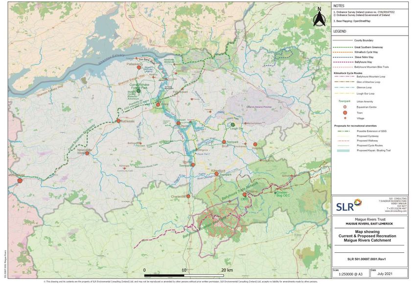
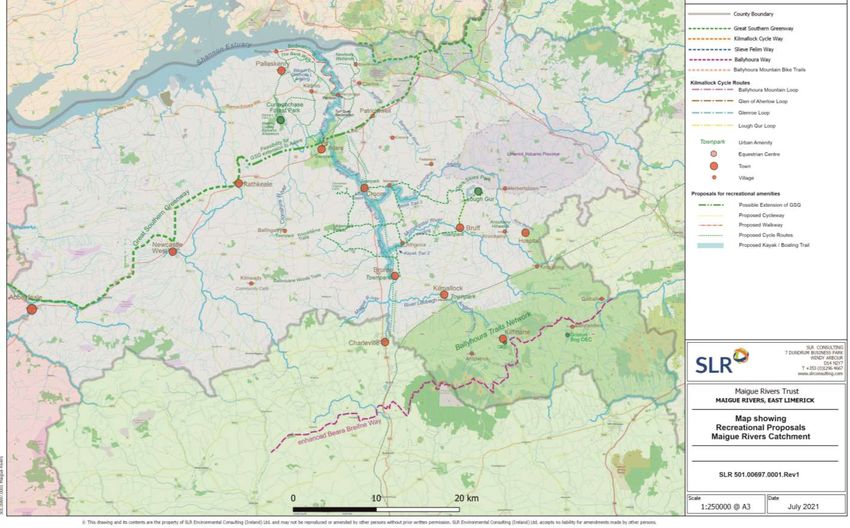
Proposals for Development
It is clear from the Phase 1 assessment that there is a significant base of recreational
amenities in the Maigue River catchments. However, gaps exist and current levels of
recreational usage are underperforming relative to the potential. This chapter makes
proposals to develop identified opportunities within five key areas of recreation.
In the following sections, proposals are made for future focus based on the five core recreation types, as well as
other amenities, within the mainly lowland areas of the Maigue catchments, as close to the river as possible:
1. Walking
2. Cycling
3. Angling
4. Boating
5. Nature & Wildlife Observation
6. Other Opportunities
For each recreational type, proposals are presented with suggested development actions, as well as enhanced
synergies to strengthen overall amenity provision in the catchment. Outline costs are presented where relevant.
The critical constraint for all riverside recreational amenities in the Maigue Catchment is the lack of access to
the riverbanks. This is due to historical private ownership rights and the intensity of equine, livestock and
dairying activities in some of the most productive agricultural lands in Ireland, as well as fears of anti-social
behaviour should access be allowed. To overcome the issue, it is proposed to utilise and enhance existing
amenities where possible, creating improved linkages, information and public engagement along the river
network.
Following the Phase 1 baseline study, the Board of the Maigue Rivers Trust requested that the focus of the
recreational amenities should lie as close to the rivers network as possible, rather than on the southern uplands’
catchment, which is well served with existing amenities.
The key proposals for recreational development are shown spatially on the Map in Figure 8 overleaf.
Page 18You can also read