Tracing the metabolic rift in Colombia's greengrocer: an environmental history of the Anaime Valley - Dialnet
←
→
Page content transcription
If your browser does not render page correctly, please read the page content below
Historia Agraria, 80 Abril 2020 pp. 71-105
                               ■           ■            ■
                                                            DOI 10.26882/histagrar.080e03d ©   2020 SEHA

Tracing the metabolic rift
in Colombia's greengrocer:
an environmental history
of the Anaime Valley
RICHARD DOUGHMAN

    KEYWORDS: Cajamarca (Colombia), environmental history, meta-
    bolic rift, arracacha.

    JEL CODES: N56, N96, O13, Q15.

               his paper stems from research to reconstruct an environmental history of agri-

    T          culture in the Anaime CanyonValley and better understand the environmental
               consequences of having transformed the area into “Colombia's greengrocer”.
    We trace the origins and development of agro-food production and explore how com-
    mercial agriculture and dairy operations have transformed the landscape and local
    ecosystems in the Anaime valley, in light of Marx's concept of metabolic rift. Research
    is based on archival sources and a participatory reconstruction of the Anaime land-
    scape from the historical memory of the campesinos, or rural inhabitants. The data
    shows how internal migration, rapid urban growth and improved transportation in-
    frastructure in the valley during the mid-twentieth century hastened the turn toward
    intensive commercial agriculture. Increasing links to Colombia's urban markets have
    led to agricultural intensification and specialization in arracacha (Arracacia xanth-
    orrhiza) production in the Anaime Canyon. As a result, soils and ecosystems have been
    depleted and agriculture depends increasingly on chemical inputs including fertilizers,
    indicating a growing metabolic rift.

                                                                                                      71
Richard Doughman
Rastreando la brecha metabólica en la despensa
agrícola de Colombia: una historia ambiental
de la cuenca del río Anaime
PALABRAS CLAVE: Cajamarca (Colombia), historia ambiental, bre-
cha metabólica, arracacha.
CÓDIGOS JEL: N56, N96, O13, Q15.
ste artículo nace de una investigación que busca reconstruir la historia am-
E biental de la agricultura en el cañón de Anaime, para entender las conse-
cuencias ambientales de su conversión en la despensa agrícola de Colombia.
Rastrea la producción agroalimentaria en el cañón hasta sus inicios y explora cómo la
agricultura comercial y la producción de lácteos han transformado el paisaje y los eco-
sistemas locales. Las transformaciones en el paisaje de Anaime se analizan a la luz del
concepto de brecha metabólica de Marx. La investigación se nutre de datos procedentes
de fuentes de archivo y de una reconstrucción participativa del paisaje anaimuno, a par-
tir de la memoria histórica de sus habitantes campesinos. Los datos muestran que la mi-
gración interna, la rápida urbanización y las mejoras en la infraestructura de trans-
porte a mediados del siglo XX aceleraron la intensificación de la agricultura en el cañón.
La creciente integración de Anaime a los mercados urbanos de Colombia condujo a la
intensificación agrícola y a la especialización en la producción de arracacha (Arracacia
xanthorrhiza). Como resultado, los suelos y los ecosistemas se han deteriorado, y la agri-
cultura depende cada vez más de insumos químicos, incluidos fertilizantes, lo que evi-
dencia una creciente brecha metabólica.
Received: 2018-10-08 Revised: 2019-04-03 Accepted: 2019-04-18
■ ■
Richard Doughman [orcid.org/0000-0001-6244-2152] is an Associate Professor at Faculty of Humani-
ties, Arts and Social Sciences, Universidad de Ibagué, Tolima (Colombia). Address: Faculty of Humanities,
Arts and Social Sciences, Universidad de Ibagué, c/ Carrera, 22 Calle 67, Barrio Ambalá, Ibagué, Tolima
(Colombia). E-mail: richard.doughman@unibague.edu.co
72 pp. 71-105 Abril 2020 Historia Agraria, 80
■ ■Tracing the metabolic rift in Colombia's greengrocer: an environmental history of the Anaime Valley
1. INTRODUCTION
Cajamarca, Colombia, gained national attention and international press in March of 2017,
when in a legally-binding, popular consultation, its citizens voted overwhelmingly to pro-
hibit mining in the municipality. The referendum side-tracked the South-African firm An-
gloGold Ashanti’s largest endeavor in the Americas, La Colosa, an open-cast gold mine
already in advanced stages of exploration. In the nearly ten years of organized resistance
and direct action leading up to the referendum, discourse centered on defending the ter-
ritory’s natural abundance and agrarian vocation against the threat of environmental de-
struction posed by open-pit mining. Many of the fiercest opponents of the mine hailed
from the Anaime Canyon, the densely cultivated valley that occupies the southern half of
Cajamarca and is largely responsible for the municipality’s fame as “Colombia’s green-
grocer” (despensa agrícola). This paper stems from research that reconstructs an envi-
ronmental history of Anaime’s agriculture, aiming to better understand the valley’s trans-
formation into Colombia’s greengrocer and the consequent environmental changes. In
doing so, it traces agro-food production back to its origins in the Anaime Canyon and ex-
plores how commercial agriculture and dairy operations have reshaped the landscape and
local ecosystems. A close eye is kept on the specific impacts wrought by the introduction
of new cultivars, farming techniques and technologies, as well as shifts in land tenure and
production relations throughout the secular expansion of agriculture and grazing in the
valley. Ultimately, the research evidences certain contradictions within a discourse that
uncritically pits the life-giving power of agriculture against the desolation of transnational
mining; agriculture in the valley today leans ever more heavily on a resource base that his-
torically it has helped to deplete.
Local actors have been the material authors of the transformation of the Anaime
Canyon, but their actions have been conditioned by social, economic and political forces
operating on a national and, increasingly, international scale. It follows then that while
Anaime Canyon sits at the center of the story, recounting how this once-peripheral ter-
ritory became incorporated into the foodshed of the nation’s largest urban markets re-
quires at least a general reckoning of how capitalist development advanced in Colombia
throughout the 20th century. Given this wider framework, transformations in Anaime’s
landscape are analyzed by light of Marx’s concept of the metabolic rift, which posits a
steady depletion of soil fertility in the countryside, as long-distance food trade breaks the
nutrient cycle, removing organic matter from the soil that the city never replenishes.
The present research follows lines laid out in a Marxist tradition of environmental his-
tory, situated between O’Connor’s (1997) histories of place with their emphasis on how
local configurations of capitalist productive forces and productive relations transform na-
Historia Agraria, 80 Abril 2020 pp. 71-105
■ ■
73Richard Doughman
ture, and the historical political ecology of the world-system set out by Hornborg (2007a)
and exemplified in the work of Martínez Alier (2007), Bunker (2007) and Moore (2003).
This latter body of work concerns itself in particular with unequal ecological exchange
between core economies and their respective peripheries, calling attention not only to the
unequal economic exchange associated with the transfer of economic surpluses from pe-
riphery to core, long documented by dependency theorists, but also to inequalities in the
appropriation of nature and the distribution of environmental risks inherent in the ex-
change of specific commodities, each with its own ecological rucksack (Martínez Alier,
2008; Pérez Rincón, 2006). As Hornborg (2007b) stresses, the size and characteristics of
the ecological rucksack depend on the material characteristics of the specific commod-
ity being extracted from the periphery and transferred to the core.
Though political ecologists have developed sophisticated instruments to quantify un-
equal ecological exchange, measured in terms of material and energy flows associated with
historical core-periphery exchange, in the case of the Anaime watershed, the available data
–both scarce and inconsistent– severely hampers any such approach. Nonetheless, evi-
dence suggests that the Anaime Canyon’s role as a provider for regional and national ur-
ban markets has upset the ecological relations of production in the valley, opening a meta-
bolic rift and calling into question the long-term sustainability of Colombia’s despensa
agrícola. Marx (1991 [1894]) employs the notion of the metabolic rift to describe the rup-
ture in nutrient cycling in the soil provoked by the extraction of organic material from the
countryside in the form of agricultural goods shipped to urban markets. In cities organic
matter not cycled back to the soil accumulates in the form of sewage posing a waste man-
agement problem; while in the countryside the metabolic rift leads to soil exhaustion. For
Marx, who based his analysis on Liebig’s research into soil fertility, large-scale agriculture
represented a form of exploitation of nature or a robbing of the soil [in which] all progress
in increasing the fertility of the soil for a given time is a progress toward ruining the more
lasting sources of that fertility(Marx, cited in Foster, 1999: 379). Owing much to Foster’s
(1999, 2000), ecological re-reading of Marx, the concept of the metabolic rift has come
into wider use to describe the fundamental ecological contradiction of capitalist pro-
duction at the heart of the antagonistic town/country, core/periphery relationships. As
Moore (2003: 326) succinctly puts it, the metabolic rift is the ecological expression of value
accumulation. For Wittman (2009: 808) the rift emerges from distancing and delocali-
sation as capital has restructured agriculture from a localized and diversified reproductive
strategy into a highly productive, market oriented, and eventually globalized form of com-
modity production. Following Foster (2013), here the metabolic rift is understood as a
more general theory of ecological crisis, describing not only the depletion of soil fertility
brought on by capitalist agriculture, but the wider rupture with what Marx termed the
universal metabolism of nature caused by the accelerated social metabolism of capitalist
74 pp. 71-105 Abril 2020 Historia Agraria, 80
■ ■Tracing the metabolic rift in Colombia's greengrocer: an environmental history of the Anaime Valley
commodity production. As such, analysis of the metabolic rift in Anaime looks beyond
the nutrient balance in the soil, and analyzes the more-general disruption in the local eco-
logical relations of production brought on by market-oriented agro-food production,
thereby including processes of soil erosion, deforestation, water pollution and reduced bio-
diversity that eventually loop back to condition production through complex agroeco-
logical cycles. In this sense, the metabolic rift opened by agriculture in Anaime results from
ecologically unequal exchange in which environmental loads or costs are displaced from
the core urban markets of Cali and Bogotá and forced upon the rural periphery.
While there is a healthy and growing body of work on environmental history in
Colombia (Palacio et al., 2001; Palacio, 2006; Palacio & Ruiz Soto, 2008; Leal, 2005; Van
Ausdal, 2009, 2012; Gallini, 2015), no detailed work has yet been done on the Anaime
Valley or upland agriculture in the department of Tolima. Cajamarca has recently been
the subject of numerous works on the nature of eco-territorial conflicts sparked by the
proposed mining project (Dietz, 2018; Jiménez, Doughman & Montoya, 2017; Sánchez
García, 2013), but none of these deal in depth with the transformation of the Anaime land-
scape prior to AngloGold’s arrival in the early 2000s. The present research seeks to pro-
vide the backstory to present-day ecological conflicts in Anaime, by illustrating how na-
ture has been appropriated and transformed historically in the valley, largely through
agricultural production, to create the present landscape and a specific set of social, eco-
nomic and cultural relations with the natural environment. The study draws on diverse
sources to reconstruct Anaime’s environmental history, including local and national
archival records, census data and fieldwork, but also actively engages the local commu-
nity in a retelling of its agrarian past1. In a workshop, over forty men and women from
Anaime and Cajamarca recounted the changes that they had observed in farming tech-
niques, the landscape, local ecosystems, diet and food production during their lifetimes.
Thirty semi-structured interviews with campesino2 men and women and muleteers com-
plemented this activity; thus, a rich, historical memory of agricultural development
reaching back to the 1940s fills voids left by the patchy register of official statistics. The
reconstruction of earlier history relies on correspondence related to the distribution of
1. The research relies heavily on qualitative data due to the paucity of reliable quantitative data on
land use and agricultural production for the study area. Colombia has undertaken only three com-
prehensive agrarian censuses (1960, 1970, 2014) and definitions for land use vary considerably from
census to census. Studies in the Cauca River Valley (MARULL, DELGADILLO, CATTANEO &, KRAUS-
MANN, 2018), suggest ways in which more detailed quantitative data on land use might obtained from
aerial or satellite imagery in the future.
2. The term campesino is preferred to “peasant” or “farmer,” to denote a culturally and historically
specific class of rural smallholders in Colombia whose livelihood derives principally from agricultu-
ral production both for subsistence and for market.
Historia Agraria, 80 Abril 2020 pp. 71-105
■ ■
75Richard Doughman
public lands in the valley at the end of the 19th century and literary sources that provide
sketches of the Anaime landscape in the decades following its colonization. Undergrad-
uate agronomy and veterinary theses from the University of Tolima, provide data on crop
diversity, production and market conditions in the years following Anaime’s entry into the
national food system at the middle of the 20th century, providing limited quantitative data
for the wide gaps between censuses.
Arguments are laid out as follows: a brief geographical description of the study area
precedes an extended, chronological account of agro-food development in the Anaime Val-
ley. This account has been divided into three periods, and in each, describes the valley’s
linkages to local, regional and national markets, as well as the ecological impacts brought
on by changes in land use and agricultural technology. A separate section then analyzes
Anaime’s increased dependence on synthetic fertilizers and other off-farm inputs as well
as changes in the nature of sharecropping agreements as evidence of the growing meta-
bolic rift produced by long-distance food trade. The concluding section offers a brief re-
flection on the relevance of these findings and the potential of further participatory re-
search to engage local campesinos in a continuing conversation on sustainability.
2. THE ANAIME WATERSHED: FROM TROPICAL JUNGLE TO
COLOMBIA’S GREENGROCER
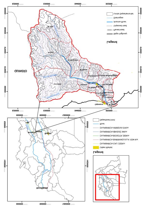
The municipality of Cajamarca in the Tolima department sits 37 km west of the depart-
ment capital of Ibagué atop the eastern slopes of Colombia’s Central Range. The Anaime
watershed covers 28,586 hectares in the south of the municipality, over half of Cajamarca’s
total area of 51,564 hectares (Map 1). The village center of Anaime is located in the lower
valley 6 km south of the municipal seat; further up the valley, El Cajón and Potosí are small
settlements served by transit and convenience stores. Temperatures average 15.9 °C and
are constant throughout the year. Average annual rainfall is just over 1,000 mm and fol-
lows a bimodal pattern with the wettest seasons coming between April and June and be-
tween October and December. Higher elevations receive greater and more evenly dis-
tributed precipitation throughout the year. Elevations in the valley range from just below
1,800 meters above sea level at the confluence of the Anaime and Bermellón rivers to over
3,500 meters along the crest of the Central Range. The middle and lower slopes of the
valley are steep, with 60% grades, but terrain grows gentler further upslope and up-val-
ley. Soil profiles are deep, a product of layers of volcanic ash deposited in the region by
successive eruptions of nearby Cerro Machín, and the more distant Tolima and Ruiz vol-
canoes.
76 pp. 71-105 Abril 2020 Historia Agraria, 80
■ ■Tracing the metabolic rift in Colombia's greengrocer: an environmental history of the Anaime Valley
MAP 1
The Anaime watershed and its relation to regional and national markets
in Colombia
Source: prepared by Jair Marroquin.
Historia Agraria, 80 Abril 2020 pp. 71-105
■ ■
77Richard Doughman
Human occupation of the Central Range dates to the late Pleistocene, and archaeologi-
cal research evidences discontinuous human settlement in the Anaime and Bermellón val-
leys prior to the arrival of the Spanish in the 16th century, with cataclysmic volcanic erup-
tions forcing humans to abandon the area for centuries at a time. Settlement continued
in the valley through the 17th and 18th centuries (Tovar, 1981) with the Anaima peoples
cultivating maize in small clearings cut into a landscape dominated by the dense high An-
dean forest (Salgado & Gómez García, 2000).
2.1. Antioquian colonization and early market links, 1860-1940
Motivated by the promise of land amid high international coffee prices, the first mestizo
settlers moved into the Anaime Canyon from Quindío in the mid-19th century, part of the
Antioquian Colonization that spread southward along both flanks of Colombia’s Central
Range. While the lower Anaime Valley was suitable for coffee plantations, lands higher up
were sown to corn for domestic consumption and livestock feed. This colonization was
part of a general expansion of Colombia’s agrarian frontier that would last into first decade
of the 20th century and leave the Central Range largely denuded of its dense native forests.
By the mid-1870s, enough colonists had settled in Anaime to petition for the con-
cession of public lands. In 1879, the Congress of the United States of Colombia, granted
20,000 hectares to the inhabitants of Anaime, then part of the Ibagué District of the Sov-
ereign State of Tolima3, and arrangements were made for the concession’s survey4.
The 1881 report of Julio Liévano, the state-appointed surveyor, offers the first written
description of the settled landscape in the Anaime valley5, and projects the optimism that
accompanied the colonizing enterprise. He lauds the land’s extraordinary vegetable wealth
and the magnificent fields of maize and wheat established by the settlers, who by his account
had been in the region for well over a decade. His report also shows considerable foresight,
predicting that before long the valley will become a source of considerable wealth developed
through agriculture and a granary for the center of the country. Yet Liévano worries that
3. The process for adjudicating public lands is set out in Law 14 of April 21 of 1870. An Agrarian
Commission made up of local farmers would assign public lands to male settlers, allowing for 32
hectares for men without children and an additional 5 hectares for every child under 21 years old in
the man’s care. Further dispositions prohibited the future sale or transfer of lands to other landhol-
ders who already possessed over 50 hectares in the area.
4. Archivo General de la Nación (AGN), fondo Baldíos, legajo 3; folios 355-357. “Los habitantes
de Fresno y Anaime se responsabilizan de la mensura de los terrenos”, 1880.
5. AGN, fondo Baldíos, legajo 3, folios 230-248. “Terrenos baldíos en Fresno y Anaime”, 1881.
78 pp. 71-105 Abril 2020 Historia Agraria, 80
■ ■Tracing the metabolic rift in Colombia's greengrocer: an environmental history of the Anaime Valley
its location –a full-day’s-ride from Ibagué over steep terrain and treacherous rivers– might
fetter trade. Later, when wheat crops have gained sufficient proportions to provide for all of
central Tolima and even for a few towns in Cauca, this point [Anaime], for lack of roads, would
be too remote to serve as a center for the transactions created by its agricultural development.
Liévano’s report and the string of correspondence between colonists in Anaime and
the Secretary of the Treasury regarding land rights reveal the same contradictions that
fraught land distribution in Colombia as a whole. Although laws with an egalitarian spirit
sought to limit the private accumulation of public lands, ministry officials often granted
immense tracts of the best lands to holders of land bonds issued to cover Colombia’s bal-
looning foreign debt (Machado, 1986). In Anaime, the law entitled settlers to lots not ex-
ceeding 50 hectares, while bondholders petitioned for holdings upward of 750 hectares
in the valley6. Liévano worried openly about the number of deedless settlers and false
deeds already circulating at the time of his visit. The limited archival record paints a pic-
ture of overlapping claims and contested interpretations of the rights accorded to culti-
vators who occupied and improved the land without legal title7. Eventually, landed in-
terests won out; by the beginning of the 20th century, a number of large haciendas raising
cattle occupied the better part of the valley. Smallholders continued to cultivate corn, cof-
fee, beans and legumes on the crowded slopes of the lower valley.
Some twenty years after Liévano’s visit, the Liberal general and politician Rafael Uribe
Uribe described Anaime in terms that echoed the surveyor’s, calling it a thing of giants
[...] for the enormous dimension of the agricultural labors undertaken by its inhabitants
(Uribe Uribe, cited in Pava, 2002: 18-9). He too praised the industry of the Antioquian
colonists who had built their own roads and bridges and were already clearing the slopes
in the highest valleys and grazing cattle in the páramos.
[Anaime] provides its fruit to Ibagué and other populations... and uses maize from
its granaries, product of its vast fields, to fatten hogs, sending 7000 of them a year
to all parts of Tolima, La Mesa, Cundinamarca, and Antioquia; as its woods have
rotted and the land has been tamed, pastures have been formed and they breed cat-
tle there and export cheese without having abandoned altogether raising hogs
(Uribe Uribe, cited in Pava, 2002: 18-9).
Thus, Anaime already formed a marginal part of Ibagué’s food system, and sent higher-
value cheese and hogs across the Magdalena to Cundinamarca or downriver to Antioquia.
6. AGN, fondo Baldíos, legajo 7, folios 66-8.
7. Law 61 of 1874 guaranteed property rights to those who farmed uncultivated government lands.
Historia Agraria, 80 Abril 2020 pp. 71-105
■ ■
79Richard Doughman
Uribe also notes the trend in which open-range grazing began to replace the relatively con-
fined hog-raising operations of Antioquian campesinos that had initially driven the local
economy. While impressed by Anaime’s prosperity, Uribe too condemns the state of the
long, hard, twisted, tiring and ridiculous road to Ibagué, that hindered an otherwise boun-
teous agricultural trade.
Its population nearing 4,0008, Anaime became a separate municipality in 1908, de-
spite the objections of a minority of politically-connected, absentee landholders who feared
an administrative break with the department capital would lower property values9.
Nonetheless, topography conspired against Anaime’s existence as a municipal seat; the
small meadow wedged between the valley walls at Las Hormas was too narrow to hold
the village’s growing population, forcing local leaders to found San Miguel de Perdomo,
now Cajamarca, on the Old Ibagué plane10. Here, the small mesa allowed for enough
growth that San Miguel eventually displaced Anaime as the municipal seat.
In the early 20th century, coffee production at the lower elevations forged an early link
between the Anaime Valley and the international market, and provided an economic moor-
ing for smallholder agriculture in the lower valley as large, livestock holdings covered the
upper valley. By this time, smallholder coffee production in the Central Range associated
with the Antioquian colonization had eclipsed the traditional coffee plantations in San-
tander and Cundinamarca and keyed the consolidation of Colombia’s coffee-based agro-
export economy (Ocampo, 2015). Notwithstanding, coffee plantations in Anaime were
limited to lower elevations along the river and nearest its confluence with the Bermellón.
Beyond this, subsistance agriculture sought mainly to feed family and livestock, while sell-
ing surpluses locally. Agricultural techniques reflected the relative shortage of labor
power, most of which was provided by family members and was likely directed toward
land clearance, which not only allowed for expanded production but constituted capital
improvement. Locals describe maize and beans as the main crops, though wheat and bar-
ley persisted on the middle and upper slopes. Often, seeds were broadcast directly onto
the untilled earth after a parcel was cleared. Pigeon peas (Cajanus cajan), were common,
as they were hardy and required no trellis.
8. AGN, fondo Baldíos, legajo 36, folio 292. “Solicitud de julio 20 de 1912 para concesión de bal-
díos para el área del poblado de Anaime”.
9. Biblioteca Nacional de Colombia, encuadernado MP1-3.
10. The plane had been the site of Ibagué’s original founding in 1539, but hostility from the Pijao’s
and a lack of nearby drinking water forced Andrés López de Galarza to abandon the plane and re-
found Ibagué at its present site after a few months.
80 pp. 71-105 Abril 2020 Historia Agraria, 80
■ ■Tracing the metabolic rift in Colombia's greengrocer: an environmental history of the Anaime Valley
Simón de la Pava’s (1991) auto-biographical novel, Este es mi testimonio, describes the
changing landscape of the upper watershed in the 1920s and 1930s. Rife with images of
the masculine dominance of nature, the novel captures the spirit of the Antioquian col-
onization, and describes how a few families amassed extensive holdings in the highlands.
He recalls the valley as an immense womb of lands cleared by men’s greed (Pava, 1991: 290)
and paints the felling of the forests in terms of epic warfare: that battle with no other weapon
than a hatchet, a saw and a hoe (ibid.: 322). In his narrative, camps of men worked con-
tinually to convert large swaths of this Andean forest to pasture often planting a crop of
potatoes first to “tame” the soil.
The novel catalogs Anaime’s diverse wildlife in detail even as it was being exterminated
by the expansion of pasturelands. Páramos were still crowded with frailejones, while moun-
tain tapirs, spectacled bears, and red brocket roamed the forests along with innumerable
species of birds. The cloud forest was thick with cedars, guarumos, laureles, chaquiros and
encenillos out of whose dense stands rose wax palms.
Despite pressure on a national scale to expand food production, Anaime remained iso-
lated in a regional economy, with surpluses being directed to Ibagué or Armenia. Incip-
ient industrialization in the early 1900s had spurred urbanization and increased the cities’s
demand for food (Ocampo, 2015), while inflation driven by the coffee boom and food
shortages in the 1920s, fueled the push for greater production of staple crops like wheat,
corn, potatoes, beans and cocoa (Kalmanovitz & López Enciso, 2006). Anaime’s remote
location had limited its participation in any nascent national market, but by the mid-1930s,
the road between Ibagué and Armenia had been improved to accommodate automobile
traffic. Trucks passing between Bogotá and Cali and the Pacific motored through the cen-
ter of Cajamarca. By the early 1940s, trucks entered the Anaime Valley as far up as the
village, though land further up remained the domain of oxen, horses and mules. Infra-
structure improvements would soon aid not only the growing flow of produce issuing from
the Anaime Valley, but also the arrival of laborers from Cundinamarca and Boyacá, largely
responsible for the coming agricultural boom.
2.2. Immigration and an agricultural boom, 1940-80
A series of reforms undertaken in the 1930s and early 1940s had primed Colombia for
further industrialization from the mid-1940s onward. Operating with a new interventionist
bent, the Colombian state placed limits on the import of finished goods and created the
Industrial Foment Institute to promote national production. The Bank of the Republic,
created in 1931, opened new lines of credit. Cali, Medellín, Bogotá and Barranquilla
Historia Agraria, 80 Abril 2020 pp. 71-105
■ ■
81Richard Doughman
emerged as powerful centers in a regionally specialized national industry, and rapid ur-
banization was already underway by the mid-1940s. Growing urban markets and the im-
perative to lower food prices as a check on worker wages prompted a geographical ex-
pansion of the cities’s provisioning systems. At mid- 20th century, the volcanic soils of the
Anaime Valley, heretofore linked mainly to regional markets in Ibagué and Armenia, were
now called upon to produce for urban centers in Bogotá and Valle de Cauca.
Geologist and engineer Otto Pichelmayr’s report11 appended to an 1943 application
for a mining title in the Cucuana drainage in the upper watershed offers a glimpse of the
valley just prior to the agricultural boom. Pichelmayr describes a picturesque valley boast-
ing abundant crops and cattle, but transportation remained a limiting factor. By his es-
timates, the cost of packing a ton of ore by mule down to Anaime stood at $9.60 pesos;
trucking the same ton to Ibagué cost another $7.00 pesos, and from there onto Bogotá
by train another $7.50 pesos.
Pichelmayr’s report suggests that land clearance in the upper watershed had advanced,
but was far from complete. He describes the solicited 1,300 hectare plot as being 75%
forested, with 15% under pasture and the remaining land planted to potatoes and wheat.
Photographs of the upper watershed show lush forests ribboned by cascading streams, but
also clearcut hillsides and felled trunks littering expanses of planted grass (Images 1 and
2).
By the late 1930s and early 1940s, immigrants began to arrive from the highlands of
Cundinamarca and Boyacá, attracted by higher wages and the relative availability of
land12. Cajamarca’s population rose from 13,384 in 1938 to 18,943 in 1951, with the large
majority (14,303) living outside the municipal seat (DANE, 1942, 1954). Immigrants
brought new cultivars and farming techniques, as well as experience in commercial agri-
cultural production. Some brought enough capital to buy land outright, while others leased
land to farm, investing proceeds in its eventual purchase. The majority accessed land as
aparceros13 on larger holdings or worked as paid laborers. For local landowners, the in-
11. AGN, fondo Minas y energía, unidad de conservación 51, folios 131-61. “Propuesta de mina
en la Floresta, zona Mirasol”. See supplementary images in the appendix: DOI https://doi.org/
10.26882/histagrar.080x03d
12. Many locals speculate that political turmoil in Boyacá and Cundinamarca associated with La
Violencia was a driver for immigrants coming to Anaime, but in the survey done by VILLAREAL and
ARIAS (1970), none of those who had come to the valley from other regions cited public unrest as the
cause of migration.
13. Aparcería is a type of sharecropping agreement in which one party, the aparcero, leases land
from the property owner, and rent is paid as a percentage of the proceeds from the crop’s sale. See
82 pp. 71-105 Abril 2020 Historia Agraria, 80
■ ■Tracing the metabolic rift in Colombia's greengrocer: an environmental history of the Anaime Valley
flux of workers eased the chronic labor shortage, and allowed them to exploit their lands
more intensively. The staples of maize, beans, potatoes, and wheat continued to thrive, but
now grew alongside patches of arracacha, cabbage, beets, peas, carrots and squash.
IMAGES 1 AND 2
Native forests cleared for pasture on the slopes of the Cucuana Drainage
of the Upper Anaime, 1943
Native forests cleared for pasture on the slopes of the Cucuana Drainage
of the Upper Anaime, 1943
Source: AGN, fondo Minas y energía, unidad de conservación 51, folios 131-61. “Propuesta de mina en la
Floresta, zona Mirasol”. Digitized by Mauricio Clavijo.
Smallholder agriculture cut away at the larger cattle operations, as the original estates were
parceled off, leased, sharecropped or bought outright by the arriving campesinos. Changes
in land use also changed the local ecology. In the Judea, Hormas, Arenillal and Águila
veredas14 cultivated fields expanded at the expense of the remaining stands of trees, leav-
ing only thin strands lining ridges and drainages and pushing wildlife out of the lower val-
ley. The widespread use of heavy hoes by the Cundiboyasenses increased soil tillage, has-
tening the erosion of the thick soils on the steep slopes of the valley.
GUTIÉRREZ MALAXECHEBARRÍA (2011) for an analysis of aparcería in the Anaime Valley.
14. In Colombia, vereda, refers to a rural administrative subdivision within a municipality.
Historia Agraria, 80 Abril 2020 pp. 71-105
■ ■
83Richard Doughman
Agricultural intensification in the Anaime Valley continued into the 1950s as infra-
structure projects tied the Anaime Canyon more closely to the regional centers of Ibagué
and Armenia and national markets in Cali and Bogotá. An improved dirt road running
between Anaime and Potosí replaced the mucky cart trail along the river in 1954 and ef-
fectively opened the canyon to motor vehicles. The immense, steel bridge spanning the
Anaime River on the Ibagué-Armenia road was finished in 1959 as part of a broader in-
frastructure initiative undertaken by the Colombian government and financed in part by
the International Bank for Reconstruction and Development.
New roads not only supplied urban markets, but conducted Colombia’s fast-growing
population out of the countryside and into the city, part of a furious process of urban-
ization in the mid- 20th century. The population of Colombia’s cities exploded as waves
of campesinos fled La Violencia, the partisan conflict that ravaged the Colombian coun-
tryside following the 1948 assassination of liberal firebrand and presidential candidate
Jorge Eliécer Gaitán. Ibagué and Armenia grew by 60.6% and 54.2% respectively between
1938 and 1954, and again by 65.8% and 75.1% by 1964 (Table 1). Bogotá was five times
larger in 1964 than it had been in 1938; Cali, another major market for Cajamarca’s pro-
duce, had grown by a factor of over six in the same period (DANE, 1954, 1967).
TABLE 1
Population of Cajamarca and its principal markets, 1938-73
Municipality 1938 1951 1964 1973
Cajamarca 13,384 18,943 16,947 15,867
Ibagué 61,447 98,695 163,661 208,699
Armenia 50,838 78,380 137,222 145,341
Bogotá 330,312 648,324 1,697,311 2,571,548
Cali 101,083 284,186 637,929 918,057
Source: DANE (1942, 1954, 1967, 1978, 1994, 2018).
As the Conservative paramilitaries known as Chulavitas and the Liberal guerrilla alter-
nately pillaged family farms, 722 cajamarcans died by violence between 1945 and 1966
(Marín, 2013)15. Between 1951 and 1964, bloodshed drove 3,544 persons out of Caja-
marca’s rural areas, and total population dropped by over 10% (DANE, 1954, 1967). Po-
litical violence also reshaped the Anaime landscape; as families in the uplands sought
15. Memories of La Violencia run strong in the older generations. Many recall details of where they
were when news of Gaitán’s assassination came over the radio; others recall sleeping in the woods at
night to hide from the Chulavitas. Stories abound of neighbor’s being shot or having their throats slas-
hed, of children being executed and corpses being displayed publicly or thrown into the river.
84 pp. 71-105 Abril 2020 Historia Agraria, 80
■ ■Tracing the metabolic rift in Colombia's greengrocer: an environmental history of the Anaime Valley
refuge down-valley, population concentrated in the densely-farmed lower reaches. Op-
portunistic landholders, often residing safely in Ibagué, appropriated abandoned lands and
livestock, solidifying the hold of large property on the upper Anaime.
Looking to feed its cities, Colombia invested in agricultural modernization in the
1950s, expanding credit through the Farm Credit Bureau (Caja Agraria) and subsidiz-
ing mechanized rice and cotton in Tolima’s lowlands along the Magdalena River, but
smallholder production on the slopes of the Central Range lay outside the scope of state
investment and Green Revolution technologies. Instead, Anaime’s agricultural bounty
grew from the natural fertility of the soils. Locals recall sowing directly in the thick hu-
mus exposed after forest clearance and cultivating without fertilizers, insecticides or her-
bicides. The 1960 Agrarian Census (DANE, 1964) bears out their accounts as only 1%
of the plots surveyed reported using synthetic fertilizers. Campesinos made ample use of
intercropping and crop rotations, growing arracacha, beans and maize in association.
Beets, cilantro, carrots and cabbage were grown together as were potatoes, peas and beans
(García & Cortés, 1973). Maize, beans and arracacha occupied the largest areas, while
wheat and barley had all but disappeared (Table 2). Coffee and plantain production,
though present in the lower valley, was concentrated in the Coello Valley between Caja-
marca and Ibagué.
TABLE 2
Agricultural production in Cajamarca, 1960
Crop Number of plots Harvested area (Ha)
Arracacha 640 1,200.6
Peas 161 199
Sugarcane 35 81.9
Onion 143 291.8
Barley 2 2
Beans 492 1,157.2
Maize 1,009 2,250.6
Potato 104 120
Cassava 104 103.7
Permanent crops
Bananas/Plantains 528 1,219.1
Coffee 628 2,385.6
Source: DANE (1964).
For agricultural lots, the dominant form of land tenure in the 1950s was aparcería, a share-
cropping agreement in which landowners provided land, rations for workers and split the
costs of seed and tools with the aparcero, who provided labor. Proceeds from the crop’s
Historia Agraria, 80 Abril 2020 pp. 71-105
■ ■
85Richard Doughman
sale were divided evenly between the two parties. Over 44% of the rural plots in Caja-
marca, some 5,700 hectares, were worked under aparcería agreements in 1960 (DANE,
1964). Aparcería provided a means for landless immigrants to access land, and while land-
holders used it to fix labor and more profitably exploit their lands.
Anaime consolidated its reputation as the Colombia’s greengrocer in the 1960s as agri-
culture expanded in the lower valley, infrastructure made markets more accessible and
chemical inputs came into wider use. By the end of the decade, the road between Caja-
marca and Anaime had been paved, and improvements had begun on the canyon road.
Local cooperatives offered regular jeep service up to Potosí16, and ten-ton trucks now
picked up produce along the road for delivery to urban markets, further integrating the
Anaime Valley into the regional and national food systems.
Over 9,000 hectares of land in Cajamarca were brought into new use during the
decade. Cultivated lands jumped from 5,396 to 7,157 hectares, while pastures grew from
22,023 to 26,666 hectares. Land ownership displaced aparcería as the predominant form
of tenure as formerly landless laborers and aparceros bought land of their own, cement-
ing the smallholder landscape that still characterizes Anaime’s lower veredas (DANE,
1974). Meanwhile, larger holdings in the upper valleys were merged and bought by a
handful of wealthy families17.
A study by Villareal and Arias (1970) renders a cross section of agricultural produc-
tion in the valley at the time. Of 82 plots surveyed, 54 were agricultural, 11 were exclu-
sively livestock operations and the remaining 17 were of mixed use. Nearly two-thirds of
the plots had an acreage below 20 hectares and a full third were under 5 hectares. Arra-
cacha, maize and potato covered nearly 75% of the cultivated area, with remaining lands
planted to beets, carrots, cabbage, beans, peas and onion. Increasingly, campesinos
farmed with the aid of Green Revolution technologies, influenced, perhaps, by agricul-
tural modernization underway in the Magdalena Valley and pressed by labor scarcity fol-
lowing the rural exodus of La Violencia. The valley’s steep terrain prohibited mechaniza-
tion, but locals recall chemical fertilizers and backpack sprayers filled with parathion and
malathion replacing older practices of soil management and pest control. Villareal and
Arias (1970) found that 70 out of 71 campesinos used insecticides, while 48 used chem-
icals on their crops to control disease; well over half used synthetic fertilizers in some form.
16. AGN, fondo INAT. “Contrato de Construcción Carretera: Anaime, La Floresta, Santa Helena.
1967-1968”.
17. Joaquín Quintero, a noted landholder haling from Boyacá, came to own a half-dozen properties
and several thousands of acres in the upper watershed.
86 pp. 71-105 Abril 2020 Historia Agraria, 80
■ ■Tracing the metabolic rift in Colombia's greengrocer: an environmental history of the Anaime Valley
Yet, this technological transfer occurred largely outside the purview of state initiatives. The
vast majority sourced seeds and propagules from their own lots or from neighbors, while
only two persons surveyed had received seeds from public entities. None of the cultiva-
tors interviewed had received technical assistance of any kind, and credit from the Caja
Agraria flowed more readily to dairy production than to agriculture.
In the upper valleys, the dual-purpose cattle herd expanded, balancing dairy and beef
production. Breeding programs were in full swing, but dairymen spurned lighter breeds
like Guernseys and Ayrshires, more appropriate for the high altitude and steep terrain,
in favor of Normandes, whose steers could be fattened more gainfully. Every day anywhere
from 6,000-6,750 liters of milk were delivered to Armenia; another 900 liters were con-
sumed locally, and 2,250 liters more were made into cheese, but there were already signs
of lagging productivity. Years of grazing had increased soil alkalinity and brought on cal-
cium and phosphorus deficiencies (Fonseca & Bernal, 1969).
Indeed, locals identify the 1960s as an important moment of ecological change in the
valley. Victims of both hunting and habitat destruction, deer, puma, mountain tapirs and
the spectacled bear had vanished from the highlands as kikuyo, meadow grass and bur-
clover had replaced the cloud forests on all but the steepest slopes. Incipient reforesta-
tion efforts planted fast-growing eucalyptus and pine rather than restore the Andean for-
est ecosystem. Hummingbirds, wasps and bees, all important for pollination, dwindled
at lower elevations as wild, flowering plants disappeared and insecticide use increased. Soil
conservation techniques remained limited; crops were often sown along on the slope,
rather than contoured; cover crops were seldom used, and weed control was done with
heavy hoes. Heavier tillage and the continued deforestation of drainages contributed to
soil erosion (Villareal & Arias, 1970); less water flowed in the streams feeding the Anaime
River, and concrete contention walls had to be built in the village to control floods caused
by sedimentation.
The 1970s saw a general increase in public investment in agriculture, including pro-
grams aiming to improve productivity in Colombia’s smallholder sector. Research and
agricultural extension from the University of Tolima arrived in Anaime as did the state
geography office, which commissioned soil studies across the region and mapped erosion
and vegetation cover in the Coello watershed. Thus, agricultural intensification in the val-
ley, begun autonomously, was now at least partially guided by state-funded research and
technology transfer.
Modernization meant increased specialization; arracacha, the most profitable cultivar,
spread over Anaime’s hillsides. Beans fell out of their association with arracacha and maize
Historia Agraria, 80 Abril 2020 pp. 71-105
■ ■
87Richard Doughman
as campesinos adapted more marketable varieties like cargamanto and bola roja that re-
quired trellises. Improved varieties of potato and corn arrived as well, certified by the
Colombian Agricultural Institute (ICA). As crop rotations simplified or were replaced by
monoculture, new pests and diseases appeared. Cutworms (Agrotis sp) affected the po-
tato, cabbage and carrot crops. The chisa (Melolonthinae) larva ate through the arracacha
patches. With new pests, came an increased use of insecticides, often applied indiscrim-
inately based on the advice of local retailers.
Agriculture in Anaime became more capital intensive and dependent on credit flow-
ing through the Caja Agraria. The private sector too stepped in, and the Bank of Colom-
bia opened a branch in Anaime. Loans were often tied to technological packages including
certified seeds and technical assistance (García & Cortés, 1973). Thus, access to credit,
in turn, spurred the modernization of agricultural practices in a mutually reinforcing cy-
cle that deepened campesino dependence both on credit and on synthetic inputs.
TABLE 3
Produce trade and principle markets of crops in Anaime, 1980
Crop Volume shipped to market (Tons) Principle markets
Arracacha 13,678.5 Bogotá, Cali, Armenia, Ibagué
Peas 582.7 Cali, Armenia, Ibagué
Beets 1,244.6 Cali, Armenia, Ibagué
Carrots 716.3 Cali, Armenia, Ibagué
Beans 507 Cali, Armenia, Ibagué
Potatoes 420 Armenia, Ibagué, Cajamarca
Tomate del árbol 62.5 Ibagué, Cajamarca
Sources: Mondragón and Motta (1980).
Production was overwhelmingly commercial; only maize and potatoes were consumed lo-
cally in any quantity. During harvest months, Anaime dispatched 790 tons a week of pro-
duce to Colombia’s urban markets. Bogotá received 350 tons of arracacha, Ibagué re-
ceived 165 tons, mainly of cabbage and beets; Armenia, 135 tons of onions, tomatoes, peas
and arracacha; Cali, 108 tons of peas, cabbage, beets, cucumbers and beans, and three
truckloads a week carried 21 tons of carrots, beets and arracacha to Barranquilla on the
Atlantic Coast18 (García & Cortés, 1973). By the decade’s end, 3,763 hectares were un-
der cultivation in the Anaime Valley alone, with arracacha –intercropped with maize– oc-
cupying roughly half of the cultivated land. Smallholder agriculture in Anaime produced
18. Calculations are based on the registry of produce transported between 1971 and 1973 by the
Transquindio and Centrolima Transport Company.
88 pp. 71-105 Abril 2020 Historia Agraria, 80
■ ■Tracing the metabolic rift in Colombia's greengrocer: an environmental history of the Anaime Valley
roughly 17,226 tons of produce for market, including 13,687 tons of arracacha, nearly
80% of which went to Bogotá (Table 3) (Mondragón & Motta, 1980).
IMAGE 3
Landslides signal erosion caused by overgrazing in the Anaime Valley
in the early 1970s
Source: Jesús A. Jordán in Rodríguez et al. (1974). Digitized by Nicolás Melgar.
Yet two decades of intensified land use had taken a toll on local ecosystems. A 1974 soil
study recognized the volcanic soil’s general aptitude for agriculture, but noted the absence
of soil conservation practices and an overall need for technical assistance (IGAC, 1974).
A 1976 study on erosion and vegetation in the Coello watershed was more condemning.
It found primary forests to be extinct on all but the steepest and wettest slopes of the wa-
tershed, including the Anaime Valley, and thinned stands of secondary forest clinging only
to ridgelines and drainages. Slumping, soil creep and landslides evinced severe erosion
where steep slopes had been overgrazed in highland pastures (Image 3). Cultivated
slopes between 1,800 and 2,400 meters above sea level showed signs of intense erosion
due to surface runoff and mass movements. The report specifically identified the Anaime
watershed as a significant contributor to the overall sedimentation of the Coello river
(IGAC, 1976). According to locals, continued deforestation at the time reduced the flow
of streams and drainages. Native species of fish, like the guilo disappeared from the Anaime
Historia Agraria, 80 Abril 2020 pp. 71-105
■ ■
89Richard Doughman
River, later to be replaced by introduced trout. The remaining stands of trees were home
to fewer birds and mammals. Populations of emblematic species like the oriole blackbird,
the Colombian chachalaca, the yellow-backed oriole, and the emerald toucanet contin-
ued to decline, likely victims of increased pesticide use.
2.3. Specialization, conservation and internationalization, 1980-Present
During the late 1970s and the 1980s, violence subsided in the Cajamarca countryside,
and the rural population –those living outside the municipal seat and Anaime’s village cen-
ter– rebounded, reaching 10,825 by 1993, an 18% increase from 1973 (DANE, 1994).
Greater population increased pressure on the land, and though the basic structure of land
tenure held, the mosaic of smallholder agriculture tightened as family lots in the lower
valley were divided among heirs. In the upper valley, too, many of the largest properties
were broken up; the number of 1,000-2,000 hectare plots dropped from eight to three
between 1971 and 1989 (URPA, 1989). One property, Potosí, was fractioned off as part
of a limited agrarian reform effort in the valley led by Colombia’s Rural Reform Institute
(INCORA). Its 1,900 hectares were purchased from the cattleman’s association and di-
vided among some sixty families, a number of them squeezed out of the lower valley and
looking for access to land upvalley19.
Behind smallholder arracacha and bean production, Cajamarca continued to play the
role of despensa agrícola. According to Tolima’s development secretary, in 1989 some
7,400 hectares in Cajamarca were planted to seasonal crops including arracacha, beans,
beets and cabbage, a 54% increase from 1970. Permanent crops such as coffee and plan-
tains had receded sharply, covering a mere 770 hectares in 1989 compared to 3,301
hectares in 1970. The dual-purpose cattle herd had grown to an historic high of 21,593
head, up from 18,330 in 1970; pastures covered nearly 30,000 hectares, a 12% increase
from two decades earlier. Natural forests had been reduced to 6,259 hectares, and sec-
ondary forests covered another 3,354 hectares. An estimated 10% of municipality’s land
was used beyond its capacity (URPA, 1989). During the 1980s, arracacha monoculture
fully replaced the older arracacha-maize association. Both fertilizer and pesticide appli-
cations increased. In the latter case, excessive pesticide use contributed to genetic resist-
ance to the organophosphorus compounds among chisas, leading the Colombian Cor-
19. Thirty years later, the results of the Potosí land reform are limited. Nearly two-thirds of the fa-
milies abandoned the project in its early stages, but by dint of political organization, the remaining
families obtained funding for a health-care post as well as a bulldozer to keep the road open. More
families were displaced by guerrilla and later paramilitary violence in the 1990s the early 2000s, and
their fractions were bought by those families that stayed, leading to re-concentration.
90 pp. 71-105 Abril 2020 Historia Agraria, 80
■ ■Tracing the metabolic rift in Colombia's greengrocer: an environmental history of the Anaime Valley
poration for Agricultural Research (Corpoica), the semi-privatized offspring of the ICA,
to research the problem in the early 1990s20 (Corpoica, 1994).
With nearly 1,850 hectares planted to arracacha and yields well above the national av-
erage (Corpoica, 1994), Cajamarca accounted for as much as 60% of the Tolima de-
partment’s production at the beginning of the 1990s and as much as a third of Colom-
bia’s annual crop. Nationwide arracacha production expanded throughout the decade
reaching an historic high in 2001 with a harvested area of 8,768 hectares. Tolima alone
harvested a record 5,202 hectares in 1999 (Ministerio de Agricultura, 2018), and at times
was the sole provider to the Bogotá market (Corabastos, 1996). Though estimates for the
cultivated area of arracacha in Cajamarca run as high as 5,000 hectares (Vásquez Acosta
& Gutiérrez, 2000), even at the historic peak of production in the late 1990s, acreage is
unlikely to have crept above 4,000 hectares21. Yet, arracacha defined the geography of
Anaime’s economy, concentrating both resources and population in the most productive
veredas in the lower valley (Vásquez Acosta & Norato, 2000), while larger producers op-
erated in the veredas La Leona, and La Despunta further up the valley (Arce et al., 2000).
Bean production, historically secondary to the arracacha, expanded throughout the
1990s and 2000s, as national production shifted south from traditional centers in An-
tioquia and Boyacá into Tolima and Huila. Tolima’s cultivated acreage grew over four fold
between 1987 and the year 2000, while its participation in national production rose over
five fold (Ministerio de Agricultura, 2018). Buoyed by sustained, high prices between 2001
and 2009, bean cultivation rivaled and occasionally surpassed arracacha production in
terms of planted area, as Cajamarca supplied markets in Medellín, Cali, Ibagué and Bo-
gotá (Ministerio de Agricultura, 2018), but increased production put renewed pressure
on forest resources as campesinos cut trees to erect trellises.
If arracacha and beans remained fixtures on Anaime’s steep slopes, the surrounding
crops began to change. Trade liberalization in the 1990s brought a new push for special-
ized fruit production as Anaime looked to foreign markets for the first time in crops other
than coffee. An assortment of passiflora (cholupa, gulupa, granadilla) as well as tomate
de árbol and lulo steadily replaced the beets, carrots and cabbages that had been cultivated
for decades. Maize, the staple of the campesino diet, a feed source for hogs and chickens,
20. Public funding for the ICA was slashed beginning in the 1980s: reflecting a worldwide trend in
shrinking pubic investment in agriculture and agricultural research (KALMANOVITZ & LÓPEZ ENCISO,
2006).
21. The difference between harvested and cultivated area varies widely from year to year. Depen-
ding on climate and pests, losses can be significant. In recent years, the MINISTERIO DE AGRICUL-
TURA (2018) has reported losses of over 20% in Cajamarca due to crop damage.
Historia Agraria, 80 Abril 2020 pp. 71-105
■ ■
91Richard Doughman
and longtime partner of the arracacha in intercropped systems, steadily disappeared from
the Anaime landscape as cheap grains became available on the market and large-scale live-
stock operations in Antioquia undercut local pork production.
Much of the agricultural expansion of the 1990s took place under guerrilla occu-
pation. Liberal guerrillas and later the Revolutionary Armed Forces of Colombia-Peo-
ple’s Army (FARC-EP), had roamed the páramos and wooded highlands since the l950s,
but in the mid-1990s, the guerrilla advanced down the valley, seizing the village in 1996.
Occupation lasted into the new millennium, when, under President Álvaro Uribe
Vélez, military and paramilitary forces entered to reclaim the region. Agricultural pro-
duction in the lower valley continued unabated despite arbitrary executions by the guer-
rilla and later massacres perpetrated by state and paramilitaries forces. However, in the
upper valley, violence harried livestock operations and displaced families to the mu-
nicipal seat in Cajamarca, Ibagué and other cities. After over a century of expansion in
the upper Anaime, dairy operations contracted in the absence of investment; landown-
ers, often victims of extortion, dared not visit their herds and instead entrusted them
to administrators. Paradoxically, the guerrilla’s presence had a regenerative effect on
highland ecosystems. Hunting and fishing in the valley were strictly forbidden, as was
the felling of timber. Amid the violence, the forest encroached on pastures; wooded
swathes linking adjacent watersheds along the spine of the Central Range formed strate-
gic corridors for covert guerrilla movement between municipalities and became de facto
conservation areas.
Even after the guerrilla’s withdrawal in the early 2000s, conservation and reforestation
efforts have continued in the upper Anaime, aided by the stagnation of the dairy sector,
whose profits have been pinched by rising production costs and increased competition
under new free trade agreements (FEDEGAN, 2014). Institutional backing has also
played an important role. In the late 1990s, local cattleman, Joaquín Quintero donated
more than 1,000 hectares at the edge of the páramo as a nature reserve. Looking to as-
sure their future water supply, rice-growers of the Coello River irrigation district (USO-
COELLO) in Espinal, bought a large tract in the Cucuana drainage for conservation.
CORTOLIMA, the departmental environmental regulation agency, procured a neigh-
boring property to the same end. More recently, in 2009, another 300 hectares on the op-
posite slope were converted to a private wildlife preserve harboring five species of Andean
parrots among dozens of other species dependent on the páramos and the high Andean
forest. In 2017, CORTOLIMA patched together these separate efforts, setting aside a to-
tal of nearly 13,000 hectares in the Anaime-Chili páramos as a Regional Natural Park pro-
tected from grazing and the more recent threat of mining.
92 pp. 71-105 Abril 2020 Historia Agraria, 80
■ ■You can also read