Chalfont St Peter Buckinghamshire Historic Towns Assessment - Buckinghamshire County Council
←
→
Page content transcription
If your browser does not render page correctly, please read the page content below
Chalfont St Peter
 Buckinghamshire Historic Towns Assessment

The town centre, Chalfont St Peter, 1931 - Britain from Above © English Heritage
The Buckinghamshire Historic Towns Project was
carried out between 2008 and 2012 by Buckinghamshire
County Council with the sponsorship of English Heritage
and the support of Milton Keynes Council and
Buckinghamshire District Councils

© Buckinghamshire County Council and English Heritage 2011

Report produced by David Green and Ruth Beckley

All the mapping contained in this report is based upon the
Ordnance Survey mapping with the permission of the
Controller of Her Majesty's Stationary Office
© Crown copyright. All rights reserved 100021529 (2011)

All historic mapping contained in this report © Intermap Technologies Ltd
unless otherwise stated

All Historic Photographs are reproduced courtesy of the
Centre for Buckinghamshire Studies unless otherwise stated.

Copies of this report and further information can be obtained from:

Buckinghamshire County Council
Planning Advisory and Compliance Service,
Place Service,
Buckinghamshire County Council
County Hall
Aylesbury
Bucks HP20 1UY
Tel: 01296 382656

Email: archaeology@buckscc.gov.uk
Contents
Summary .................................................................................................................................................. 5
I DESCRIPTION ................................................................................................................................... 8
1 Introduction ...................................................................................................................................... 8
1.1 Project Background and Purpose ............................................................................................ 8
1.2 Aims ......................................................................................................................................... 8
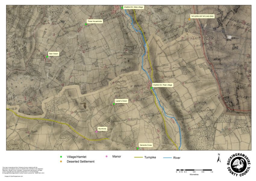
2 Setting ............................................................................................................................................. 14
2.1 Location, Topography & Geology .......................................................................................... 14
2.2 Wider Landscape ................................................................................................................... 14
3 Evidence .......................................................................................................................................... 15
3.1 Historic Maps.......................................................................................................................... 15
3.2 Documentary Evidence .......................................................................................................... 15
3.3 Built Heritage .......................................................................................................................... 15
3.4 Archaeological Evidence ........................................................................................................ 16
3.5 Environmental Evidence ........................................................................................................ 17
4 Archaeological & Historical Development ................................................................................... 20
4.1 Prehistoric and Roman evidence period (c.10,000 BC – AD 43)........................................... 20
4.2 Saxon and Medieval synthesis ( AD 410 -1536) .................................................................... 22
4.3 Post medieval synthesis and components (1536-1800) ........................................................ 28
4.4 Modern synthesis (1800-Present) ......................................................................................... 32
II ASSESSMENT ............................................................................................................................. 42
5 Designations ................................................................................................................................... 42
5.1 Conservation Areas (CA) ....................................................................................................... 43
5.2 Register Parks and Gardens .................................................................................................. 43
5.3 Scheduled Monuments .......................................................................................................... 43
5.4 Archaeological Notification Areas .......................................................................................... 43
5.5 Listed Buildings ...................................................................................................................... 43
6 Historic Urban Zones ..................................................................................................................... 44
6.1 Introduction............................................................................................................................. 44
6.2 Historic Urban Zones ............................................................................................................. 44
6.3 Archaeological Assessment ................................................................................................... 44
6.4 Heritage Values ...................................................................................................................... 47
6.5 Historic Settlement ................................................................................................................. 49
Modern Settlement............................................................................................................................... 52
III RECOMMENDATIONS ................................................................................................................ 56
7 Management Recommendations .................................................................................................. 56
7.1 Conservation Area Appraisals................................................................................................ 56
7.2 Listed Buildings ...................................................................................................................... 56
7.3 Registered Parks and Gardens .............................................................................................. 56
7.4 Archaeological Notification Areas .......................................................................................... 56
7.5 Scheduled Monuments .......................................................................................................... 56
8 Research Agenda ........................................................................................................................... 56
8.1 Roman .................................................................................................................................... 56
8.2 Saxon ..................................................................................................................................... 56
8.3 Medieval ................................................................................................................................. 56
8.4 Post Medieval ......................................................................................................................... 57
8.5 Modern ................................................................................................................................... 57
9 Bibliography ................................................................................................................................... 58
10 Addresses ................................................................................................................................... 59
1 Appendix: Chronology & Glossary of Terms .............................................................................. 60
1.1 Chronology (taken from Unlocking Buckinghamshire’s Past Website) .................................. 60
1.2 Glossary of Terms .................................................................................................................. 60
2 Appendix: HER Records ................................................................................................................ 61
2.1 Monuments HER Report ........................................................................................................ 61
2.2 Landscapes HER Reports...................................................................................................... 64
2.3 Find Spots .............................................................................................................................. 65
2.4 Listed Buildings ...................................................................................................................... 69
3 Appendix: Trade Listings and Population Data .......................................................................... 71
4 Appendix: Historical Consultancy Report ................................................................................... 73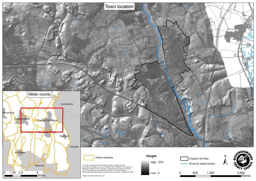
Chalfont St Peter Historic Town Assessment Report

List of Illustrations
Figure 1: Urban Character Zones, Chalfont St Peter ................................................................................ 6
Figure 2: Chalfont St Peter in location ....................................................................................................... 9
Figure 3: Geology of town (BGS) ............................................................................................................ 10
Figure 4: Diagram of Connections from Chalfont St Peter (representational only) ................................. 11
Figure 5: Town in the wider historic landscape using routes and Bucks HLC ........................................ 12
Figure 6: Dispersed settlement around Chalfont St Peter ....................................................................... 13
Figure 7: Listed Buildings by century ...................................................................................................... 15
Figure 8: Historic maps:........................................................................................................................... 18
Figure 9: Listed buildings & archaeological investigations in Chalfont St Peter ..................................... 19
Figure 10: Coin Hoard at Whan Field, Chalfont St Peter ........................................................................ 20
Figure 11: Prehistoric & Roman evidence ............................................................................................... 21
Figure 12: Nos 39-49 High Street, Chalfont St Peter prior to demolition – (Stell 1969). ......................... 25
Figure 13: Crown Post roof in No. 31 High Street ................................................................................... 25
Figure 14: Chalfont St Peter – Medieval Settlement and Landscape ..................................................... 26
Figure 15; Chalfont St Peter, historic core, medieval extent ................................................................... 27
Figure 16: St Peter's Church ................................................................................................................... 29
Figure 17: Possible extent of the town in the post medieval period ........................................................ 31
Figure 18: St Joseph’s church ................................................................................................................. 33
Figure 19 Market Place, Chalfont St Peter c. 1950-1959 ........................................................................ 33
Figure 20: The Chalfont Centre ............................................................................................................... 34
Figure 21: Maltmans Green School ......................................................................................................... 35
Figure 22: Latchmore Grove.................................................................................................................... 36
Figure 23: St Peter's Court Shopping centre ........................................................................................... 36
Figure 24: Population of Chalfont St Peter (excluding 1941 & 1981) ..................................................... 37
Figure 25: Chalfont St Peter in the 1880s to 1920s ................................................................................ 38
Figure 26: Chalfont St Peter in the post war to modern period ............................................................... 39
Figure 27: Morphological and period development ................................................................................. 40
Figure 28: Architectural styles ................................................................................................................. 41
Figure 29: Conservation areas in Chalfont St Peter ................................................................................ 42
Figure 30: Diagram showing the processes involved in the creation of the urban character zones ....... 45
Figure 31: Historic Character Zones for Chalfont St Peter ...................................................................... 48

Table 1: Checklist for Chalfont St Peter .................................................................................................... 7
Table 2: Early 18th century Inhabitants of Chalfont St Peter and their professions................................. 28
Table 3: Summary of trade in Chalfont St Peter 1830-1935 (method adapted from Broad, 1992)......... 32

                                                                                                                                                         4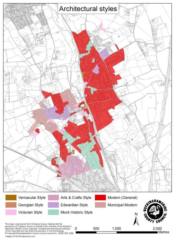
Chalfont St Peter Historic Town Assessment Report

   Summary

   This report written as part of the Buckinghamshire Historic Towns Project is intended to
   summarise the archaeological, topographical, historical and architectural evidence
   relating to the development of Chalfont St Peter in order to provide an informed basis for
   conservation, research and the management of change within the urban environment.
   Emphasis is placed on identifying a research agenda for the town and on a semi-
   quantitative method for defining local townscape character. The Historic Towns
   methodology complements the well-established process of conservation area appraisal
   by its complete coverage, greater consideration of time-depth and emphasis on research
   potential. Each Buckinghamshire Historic Towns Project report includes a summary of
   information for the town including key dates and facts (Table 1). The project forms part
   of an extensive historic and natural environment characterisation programme by
   Buckinghamshire County Council.

   Situated between Amersham and Gerrards Cross and to the south of the Chilterns Area
   of Outstanding Natural Beauty, Chalfont St Peter is today regarded as a ‘suburban
   village’ which expanded rapidly in the 20th century. However, examination of its early
   history shows that there was an attempt to develop Chalfont into a commercial centre,
   but it never actually became anything more than a large village. Historically Chalfont
   was first mentioned in AD 949 in the Anglo Saxon Chronicles but there was no
   distinction made between the three separate Chalfont villages, the whole area was known
   as Ceadeles funtan. Chalfont St Peter seems to have been a small common edge
   settlement manor with a mill situated with in the woodland landscape of the Chilterns.
   The founding of a market and fair in 1229 is a key point in Chalfont’s history but it was
   not the catalyst for growth or expansion and it doubtful if the market was ever
   successful, there is little documentary evidence of urban trades or professions. For most
   of the medieval period the manor of Chalfont St Peter was held by Missenden Abbey until
   the dissolution when it passed to a succession of families including the Drurys, the
   Bulstrodes and the Whitchurch family who held it from 1650 to 1809.

   In the post medieval period (1536 -1800) documentary sources indicate that Chalfont did
   not expand, retaining its village character, although by the late 18th century it possessed
   a substantial non agricultural population with an unusual number of trades; these
   included: blacksmiths, butchers, bakers, cordwainers, glaziers and victuallers.

   In the twentieth century Chalfont St Peter was transformed into town, based upon a large
   suburban settlement, the catalyst being the arrival of the railway at Gerrards Cross which
   connected this part of Buckinghamshire to London and Birmingham. The first major
   development occurred to the south around Austenwood Common with the Arts and
   Crafts styled villa at North Park, and Latchmoor Grove. Much larger developments came
   in the late 1920s. Shops of this period that run along the main street towards Gold Hill
   common, now comprise most of the village centre. Residential development continued
   apace; houses were built in the 1950s and 1960s to the east of Gravel Hill. This
   widespread growth saw Chalfont St Peter’s population rise from c. 6,000 in 1931 to over
   12,000 by 1961. Modernisation and urbanisation continued up until 1960s when many
   historic shops in the High Street were demolished in favour of a concrete development of
   flats, offices and shops fronts surrounding a central car park. Modern buildings and
   urbanisation now dominate the village centre and very little historic architecture remains.

                                                                                                 5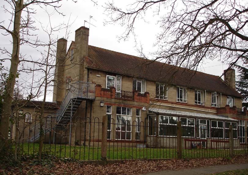
Chalfont St Peter Historic Town Assessment Report

   A consequence of modern urbanisation is that of Chalfont St Peter has coalesced with
   Gerrards Cross and it is hard to distinguish a boundary between the two settlements.

   Chalfont St Peter is significant for it’s the setting of its village environment, a series of
   commons with historic settlement clustered around the edges. The area encompassing
   the church and High Street, which has lost much of its green through development still
   has the potential to yield archaeological deposits from the medieval and post medieval
   periods. However, aside from the historic core of the village perhaps the most significant
   aspect of Chalfont’s heritage lies with its historic built environment of the 19th and 20th
   centuries; which charts the transformation of a historic village into a twentieth century
   ‘metroland settlement’. Some of the most significant features are individual buildings
   such as The Grange, the 1920s promenade of shops along the Market Place and the
   National Centre for Epilepsy. A number of estates merit recognition including the villa
   settlements of Austenway and Latchmoor Grove.

                           Figure 1: Urban Character Zones, Chalfont St Peter

                                                                                                   6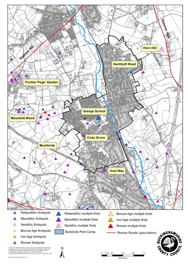
Chalfont St Peter Historic Town Assessment Report

     Period                                          Chalfont St Peter
                               Mint                                           No
                              Minster                                         No
     Saxon
                            Royal Manor                                       No
   (410-1066)
                            Burh status                                       No
                          Saxon Reference                           949 as Ceadeles Funtam
                        Domesday Reference                               Yes as Celfunde
                         Number of Manors                                 One reference
   Domesday                   Watermills                                        One
    (1086)
                   Domesday population (recorded               14 villagers; 4 smallholders; 2 slaves
                          households)
                         Settlement type                                 Manorial holding
                           Borough status                                      No
                            Burgage plots                                      No
                        Guild house/fraternity                                 No
                                Castle                                         No
                           Civic structures                                    No
                             Fair Charter                        1229 (Letter Close) Ranulf Brito
                               Church                                   St Peter’s Church
    Medieval
                           Market Charter                        1229 (Letter Close) Ranulf Brito
  (1066-1536)
                            Market House                                       No
                         Monastic presence                                     No
                          Manorial records                           Yes good preservation
                       Routeway connections
                     Inns/taverns (reference to)                          No reference
                        Windmills/watermills                                  One
                           Settlement type                                market village
                               Industry                                       Not known
                       1577 Return of Vintners                  2 inn holders; 1 alehouse keeper
                          Market Charter                                        No
                           Market house                                         No
                            Fair Charter                                        No
 Post Medieval                  Inns                           Greyhound, Swan and Cross Keys
  (1536-1800)                Watermills                                        One
                             Windmill                        Mention of one at Austenwood Common
                        Proximity to turnpike                   1751 Uxbridge to Wendover Trust
                                                                1751 Beaconsfield to River Colne
                          Population (1801)                                  1174
                           Settlement type                                  village
                            Railway station                        1906 Gerrards Cross Station
                        Modern development                                     Yes
                            Enclosure date                                  No date
    Modern                    Canal Wharf                                       No
  (Post 1800)         Significant local industries                     Local film industry
                          Population (2001)                                  12,936
                           Settlement type                              Suburban village
                               HER No.                                    0855800000
                                   Table 1: Checklist for Chalfont St Peter

                                                                                                        7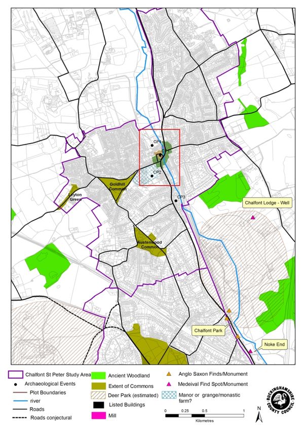
Chalfont St Peter Historic Town Assessment Report
I DESCRIPTION
1 Introduction
1.1 Project Background and Purpose
The Buckinghamshire Historic Towns Project forms part of a national programme of projects funded by
English Heritage (EH) based on the archaeology, topography and historic buildings of England’s historic
towns and cities.
This Historic Settlement Assessment Report for Chalfont St Peter has been prepared by the
Buckinghamshire County Archaeological Service as part of the Buckinghamshire Historic Towns Project
to inform and advise the planning process. This report has been compiled using a number of sources,
including the Buckinghamshire Historic Environment Record (HER), the List of Buildings of Architectural
and Historical Interest and selected historical cartographic and documentary records. Site visits were
also made to classify the character of the built environment. The preparation of this report has involved
the addition of information to the database and the digitising of spatial data onto a Geographic
Information System (GIS). In addition, this report presents proposals for the management of the historic
settlement archaeological resource.
1.2 Aims
The overall aim of the project is to inform management of the historic environment within
Buckinghamshire’s urban areas. Specifically, it will
Improve the quality and environmental sensitivity of development by enhancing the consistency,
efficiency and effectiveness of the application of Planning Policy Statement 5 covering the historic
environment.
Inform the preparation and review of conservation area appraisals
Where appropriate, assist with the development of Town Schemes and urban regeneration
projects
Inform Local Development Frameworks, especially in the recognition of historic townscape
character
Act as a vehicle for engaging local communities by promoting civic pride and participation in local
research and conservation projects.
Build upon the original Historic Landscape Characterisation (HLC) for Buckinghamshire
(completed in 2005) through the addition of more detailed characterisation of the urban
environment.
Address an agenda recognised in the Solent Thames Research Frameworks for Buckinghamshire
(2006) regarding a lack of knowledge of the built environment and in particular the need for
research into land use continuity and internal planning within Buckinghamshire’s early towns.
8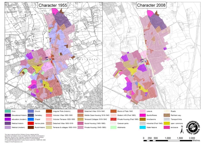
Chalfont St Peter Historic Town Assessment                                             Draft Report

                                             Figure 2: Chalfont St Peter in location

                                                   9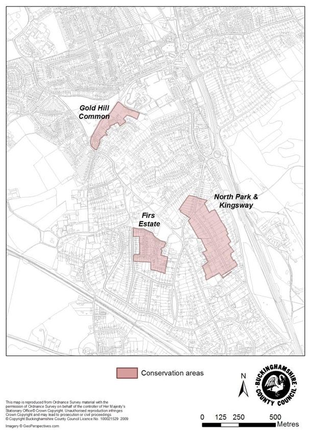
Chalfont St Peter Historic Town Assessment                                     Draft Report

                                             Figure 3: Geology of town (BGS)

                                               10
Chalfont St Peter Historic Town Assessment Draft Report
Figure 4: Diagram of Connections from Chalfont St Peter (representational only)
11Chalfont St Peter Historic Town Assessment Draft Report
Figure 5: Town in the wider historic landscape using routes and Bucks HLC
12Chalfont St Peter Historic Town Assessment Draft Report
Figure 6: Dispersed settlement around Chalfont St Peter
13Chalfont St Peter Historic Town Assessment Draft Report
2 Setting
2.1 Location, Topography & Geology
For the purposes of this report the division between Chalfont St Peter and Gerrards Cross will
be taken to be the political boundary line north of the railway that demarcates Chiltern and
South Bucks Districts. This places Ochre Hill Avenue, South Park, Oak End Way and
Packhorse Road in Gerrards Cross while Maltman's Lane, Austenwood Common, Latchmoor
Way and North Park are in Chalfont St Peter.
Chalfont St Peter is located in Chiltern District in the county of Buckinghamshire along the
historic road from London to Birmingham. Chalfont St Peter is a nucleated settlement located at
a height of approximately 65m OD (Ordnance Datum). Modern settlement has expanded over
the low valley slopes around the village, rising to a height of 95m OD to the north east and
100m OD to the south west.
The river Misbourne passes through the centre of Chalfont St Peter running north-south from
Great Missenden to the River Colne.
The principal bedrock geology around the historic settlement comprises Upper Chalk formation
with bands of Lambeth clay topping the hills to the north and south. Overlying superficial
deposits comprise alluvium along the path of the river Misbourne and Ancestral Thames river
terrace deposits on the surrounding hills. The Soil Survey Layer (Cranfield University, 2007)
surveyed at a county level classifies the soils to the west of the historic core as loam over gravel
(Soil Series 5.81 Typical paleo-argillic brown earths). The path of the river is classified as
seasonally wet loam over gravel (Soil Series 8.12 Calcareous alluvial gley soils) with areas of
deep loam to clay in the east (Soil Series 5.81 Typical paleo-argillic brown earths).
2.2 Wider Landscape
Transport and Communications
The principal historic road passes through Chalfont St Peter on a north-south alignment from
Birmingham via Aylesbury to London. This route is presumed to have medieval origins – it was
first recorded in detail on John Ogilby’s strip map of 1675 and was later turnpiked by the
Wendover to Buckingham Trust in 1751. The turnpike continued to operate until 1878 when the
turnpikes were closed down. A number of local roads connect surrounding villages to Chalfont
St Peter.
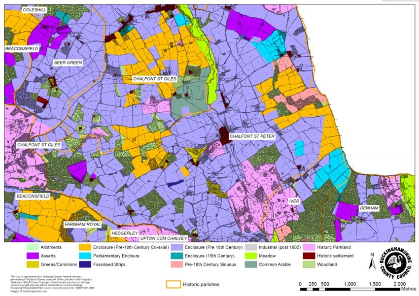
Rural Landscape
The 19th century landscape was dominated by pre 18th century irregular enclosure with small
areas of settlement at Chalfont St Peter itself and at Austenwood and Goldhill Common. The
Grange comprised a small park near to the village while Chalfont Park lay a short distance
away.
The modern landscape has seen significant change. The introduction of the railway at Gerrards
Cross and subsequent expansion of that town quickly encroached into Chalfont parish and led
to the creation of a new parish for Gerrards Cross. Chalfont St Peter benefited from the
‘metroland’ appeal of the London hinterland as settlement expanded north from Gerrards Cross
to the meet with the village. The creation of a National Centre for Epilepsy at Chalfont Common
marked the northern most limit of the new settlement. The pre 18th century field systems have
now been replaced by built development and modern field patterns.
14Chalfont St Peter Historic Town Assessment Draft Report
3 Evidence
3.1 Historic Maps
Characterisation for this project was primarily undertaken using the Ordnance Survey series of
maps from the OS 2” Surveyors drawing of the 1820s to the current Mastermap data. Also
used were county and regional maps including Jeffrey’s map of the county (1760) and Bryant’s
map of the county (1820). The only available historic map for Chalfont St Peter is the Tithe
Award from 1840.
3.2 Documentary Evidence
In comparison with other historic towns and settlements in Buckinghamshire the documentary
evidence for Chalfont St Peter is very rich. The manorial records for Chalfont manor survive,
which provide much information about fourteenth and early fifteenth-century Chalfont St Peter.
There is a good series of Overseers’ and other parish records from the eighteenth and
nineteenth centuries, and several large collections of estate records from the sixteenth to
nineteenth centuries, which make it possible to study the development of the parish’s
landholding patterns, farming and landscape in great detail. The major holdings of estate deeds
are listed in the Early Modern Records section, under ‘Other records’ and ‘Title deeds’. The full
assessment of documentary sources has been produced by Matt Tompkins of the University of
Leicester, and is available in Appendix 4. In terms of synthesised secondary sources there is
G. Edmunds’ history of Chalfont St Peter and Gerrards Cross (1964) which discusses the early
history of the settlement. Hunt and Thorpe’s book on Gerrards Cross (2006) is very detailed on
the history of modern ‘metroland’ development and discusses the growth of neighbouring
Chalfont St Peter in some detail. There are also two recent pictorial histories of Chalfont St
Peter compiled by Peter Seabright (2006) which contain useful illustrations and photographs of
from the early 20th century.
3.3 Built Heritage
There are just fifteen listed buildings in Chalfont St Peter dating from the 15th-20th centuries. St
Peter’s Church, originally dating to the 15th century and Shrubs Wood are the only Grade II*
buildings. The listed buildings are spread across the town with some modern buildings at the
Epilepsy Centre and in the south of the town while a cluster of earlier buildings are concentrated
around the village.
6
5
4
3
2
1
0
y
y
y
y
y
y
ur
ur
ur
ur
ur
ur
nt
nt
nt
nt
nt
nt
Ce
Ce
Ce
Ce
Ce
Ce
th
th
th
th
th
th
15
16
17
18
19
20
Figure 7: Listed Buildings by century
15Chalfont St Peter Historic Town Assessment Draft Report
3.4 Archaeological Evidence
Previous archaeological investigation in Chalfont St Peter has been limited, two investigations
some distance from the village centre proved negative. A small scale evaluation within the
grounds of the church has provided some evidence of medieval activity.
CP1: St Peters Church NGR TQ 0005 9089 (Pine J, 2000)
Finds Negative features (cut only) Environmental evidence
1 sherd pottery (Roman) robber trench (medieval) 3 burials (medieval?)
2 sherds pottery (medieval sandy 6 burials (post medieval)
ware 12th-14th century) Above ground structures
1 sherd pottery (‘M40’ type ware 12th None
century) Positive features (above natural)
1 sherd pottery (post medieval) None
2 fragments architectural stone
1 fragment clay pipe
ceramic building material
Circumstances of investigation Conclusion
Source: Unpublished archaeological Report indicates that the robber trench marks the line of the
document original medieval church. Several of the burials were
Archive: County Museum discovered beneath this robber trench indicating a medieval
date.
CP2: The Grange NGR TQ 0005 9089 (Museum of London, 2004)
Finds Negative features (cut only) Environmental evidence
Prehistoric Prehistoric 1 fragment of animal bone
25 flints (majority Neolithic Bronze Age)
Medieval Pottery Ditches gully (prehistoric)
Above ground structures
Medieval
- 7 sherds of Flint Tempered Pottery None
th th
(11 to 12 century) Possible boundary ditches, Positive features (above natural)
Post medieval Post-medieval
Post Medieval Pottery
- Wall, and possible floor
- 1 sherd of Surrey Red Border ware - Post holes
(16th – 17th century)
- Pit
- 1 sherd of tin-glazed ware (17th
century)
- 1 sherd locally made red earthenware
(17th century) possibly Surrey border
ware or Brill Boarstall
Undated
2 pieces of slag
Circumstances of investigation Conclusion
Archaeological Evaluation The results of the evaluation have shown potential prehistoric
Source: Unpublished archaeological features including a ditch and a possible eaves drip gully
document suggesting a domestic settlement.
Archive: County Museum
Evidence for medieval occupation is slight although presence
of stratified medieval pottery in boundary ditches.
Walls and a possible floor and post holes. These
structures may relate to a building or to garden features of the
post-medieval period.
16Chalfont St Peter Historic Town Assessment Draft Report
Several archaeological investigations within the historic settlement did not find any significant
archaeological features, most likely due to either the extent of modern redevelopment in the
area or to the limited nature of the archaeological activity.
Code Activity Address NGR Date Summary
type
CP3 Evaluation 59-63 Lower Road TQ 0025 2002 Negative – no archaeological features
9030 (Hounsell D & Keir W)
CP4 Excavation Allotment site TQ 999 2003 Negative – modern disturbance
912 (Small-scale training excavation by the
Chiltern Young Archaeologists Club)
3.5 Environmental Evidence
In assessing the potential for environmental remains, it should be remembered that an urban
environment can provide extremes in preservation. On the one hand proximity to the
groundwater table within a historic core may lead to anoxic conditions and therefore good
preservation potential for organic materials whereas on the other hand frequent below ground
disturbance as a result of redevelopment and construction combined with modern industrial
pollution can also lead to extremely poor preservation of organic materials (French, 2003).
There has been no environmental analysis undertaken in Chalfont St Peter. The underlying
geology of the town is made up of a combination of Upper Chalk and Lambeth clay mudstone,
capped with Alluvium from river Misbourne and Thames river terrace deposits. The soils are
permeable, loamy clays. The chalk bedrock is conducive to the preservation of land molluscs,
and animal or human bone. Waterlogged remains might survive in the floodplain but elsewhere
are unlikely. .
17Chalfont St Peter Historic Town Assessment Draft Report
1840 Tithe Map
1900 OS 2nd Edition
Figure 8: Historic maps:
18Chalfont St Peter Historic Town Assessment Draft Report
Figure 9: Listed buildings & archaeological investigations in Chalfont St Peter
19Chalfont St Peter Historic Town Assessment Draft Report
4 Archaeological & Historical Development
4.1 Prehistoric and Roman evidence period (c.10,000 BC – AD 43)
There are no extant prehistoric monuments in Chalfont St Peter, although the most substantive
archaeological discovery was made during an excavation of The Grange (CP2) where Neolithic
to Bronze Age features of ditch termini and a possible eaves drip gully were unearthed. The
eaves gully could suggest a domestic settlement, although this is tentative interpretation and
would require confirmation via further fieldwork, (MOLA 2010). Apart from The Grange,
evidence has been restricted to a number of isolated finds in and around the village;
Palaeolithic, Mesolithic and Neolithic/Early Bronze Age flint artefacts have been found in the
area but are mostly from layers disturbed by later activity. However an undisturbed Mesolithic
flint scatter found in advance of the construction of the M25 at Marsh Farm. There is the
potential for well preserved prehistoric sites along the valley floor as seen elsewhere along the
River Colne and its tributaries. A ring-ditch and linear cropmark seen on an aerial photograph
at Mumford’s Farm may also date to the prehistoric period.
The evidence for Roman settlement in Chalfont St Peter is also scant. There have been a
number of separate finds of Roman artefacts found around the town, the most significant being
a Roman coin hoard found in the plough soil at Whan Field, (HER 0507070000). Three pottery
urns were unearthed containing coins dating to the 3rd century AD. The coins were deliberately
hidden in isolation and a subsequent archaeological survey and excavation of the surrounding
landscape located a further coin laden vessel; however there was no evidence of a Roman
settlement (Cleary 1994). Coins and ‘other remains’ were also discovered when Chalfont St
Peter cricket ground was being enlarged in 1899, this prompted speculation that this was the
site of a villa (HER 0083100000) however as yet there is no archaeological evidence of Roman
settlement in Chalfont St Peter. It has been conjectured that two Roman roads pass in close
proximity to Chalfont St Peter. One of these routes runs to the east of the village along an
alignment from Verulamium (St Albans) to Hedsor Wharf (163) while to the west is a second
route thought run Chorleywood to Langley Park (163b) (Viatores 1964). Neither road has
been confirmed by archaeological investigation and both should be considered highly
speculative.
Figure 10: Coin Hoard at Whan Field, Chalfont St Peter
20Chalfont St Peter Historic Town Assessment Draft Report
Figure 11: Prehistoric & Roman evidence
21Chalfont St Peter Historic Town Assessment Draft Report
4.2 Saxon and Medieval synthesis ( AD 410 -1536)
Place name evidence
The earliest reference to Chalfont St Peter comes from the Cartularium Saxonicum in 949 AD
where it is referred to as Ceadeles Funtam. The name is thought to translate as ‘Caedel’s
Spring or fountain (Mawer & Stenton, 1925). Interestingly this is a latinLatin placename rather
than a Germanic one; this might be indicative of Saxon settlers maintaining an existing Roman
placename describing a functioning Roman fountain. Chalfont is next mentioned in Domesday
simply as Celfunde while the suffix ‘St Peter’ does not appear until the mid 13th century when
the 1236-1237 Book of Fees refers to the place in the Latin form as Chalfhunte Sancti Pietri
(ibid).
By the 11th century the manor of Chalfont St Peter is thought to have comprised much of the
land in the historic parish. Before the Norman Conquest the manor was in the ownership of Earl
Leofwine and was worth 110 shillings (Morris 1978).
Archaeological evidence
There is a paucity of archaeological evidence for the Saxon period in Chalfont St Peter. The
only known find is represented by a single bead found in the 1930s at Chalfont Cottage Hospital
by workmen (Rouse 1931) (HER 0158300000). The only other notable finds occurred at
Chalfont park, where several sherds of Anglo Saxon pottery were recovered within the parkland
(HER 0626800000).
Domesday
Domesday Book contains one reference to Chalfont St Peter, at that time held under one
principal manor in the ownership of the Bishop of Bayeaux. The manor comprised four hides
and three virgates (c.570 acres) with land for 15 ploughs and meadow for a further two.
Additional information in Domesday also records one mill worth 6s, woodland for 600 pigs and a
hawk’s eyre. The recorded population of the manor comprised 14 villager, four smallholder and
two slave households (Morris 1978).
From the Domesday entry it appears that Chalfont was originally one parish but seems to have
been split into two parts sometime after Domesday (Edmonds 1964). Chalfont was granted to
Odo Bishop of Bayeux in 1066 who held the manor to be administered by one of his knights,
Roger d’ Anquertil de Turville.
‘Town’ Layout
Nothing is known of the layout of the Anglo-Saxon settlement. The medieval plan form of
Chalfont St Peters is very much that of a village rather than a town. The main settlement was
centred upon the crossroads of Market Place (formerly Gold Hill Lane) and the crossing of the
High Street. The meeting place of three roads must have been one of the attractions for
establishing a market and fair in the 13th century (see manors below). However analysis of
historic maps shows little evidence of medieval town planning; there are no characteristic long
straight tenement or ‘burgage type plots fronting onto a long High Street Instead the High
Street, which is orientated north south, is comparatively shorter in length. The southern end of
the High Street is thought to have opened up into a larger open space - a green or square which
may have also encompassed St Peter’s church and its churchyard. This Green would have
been a suitable venue for the market and fair. The plots abutting the green tend to be small,
irregular and sinuous in form, indicative of piecemeal development and more reminiscent of
boundaries found in villages and hamlets. From this evidence it is possible to infer only the
characteristics of a well established village; the commercial aspirations of its owners seemingly
failed to transform the settlement into the form expected of a thriving town.
Church
It is believed that the church was built in the 12th century and dedicated to St Peter (Edmonds
1968). In 1714 there was a disaster when the medieval tower collapsed onto the nave and
aisles; the entire church was demolished and rebuilt in 1718 (Pevsner & Williamson 1994
p.219). Not much is known about the fate of the original church fabric, although when extensive
22Chalfont St Peter Historic Town Assessment Draft Report
repairs were made to the nave in 1965, many fragments of moulded stone were discovered
along with timber beams and the foundations of earlier buildings were revealed which were
believed to be from the remnants of the medieval church. (Recs of Bucks 416 xviii 97)
Chantry chapel
A chantry chapel is recorded as being founded at St Mary’s altar in St Peter’s Church by the
bequest of William Whappelode in 1447 (Lipscomb 1848 pp 245-246 & VCH 1927). There is no
separate structural evidence for a separate chapel but probably a dedication of an altar. The
chantry was eventually suppressed and closed down in 1547 (Rouse 1927). However it has
been speculated that that a house belonging to the Chantry priests was located opposite the
church (see secular buildings below)
Names of some Chantry Priests at Chalfont St Peter
1452 - Thomas Mere Gilbert Denys aged 60 is called a
chantry priest in the reign of Edward
1459 - Thomas Wheeler
VI but we do know that Thomas
1469 - Robert Wakefield Langshawe was the last of the
Whappelode Chantry priests.
1501 - William Wodecroft
1552 - Thomas Langshawe (prior to 1535)
Manors
The following summaries are taken primarily from the Victoria County History and are limited in
the data they provide. The histories of the manors around Chalfont St Peter are complex and a
more detailed study is required to fully understand them. A complete catalogue of the available
documentary evidence relating to medieval manors is now available online via the National
Archives Manorial Documents Registry produced in 2008 by the Centre for Buckinghamshire
Studies and the National Archives.
Chalfont Manor
This manor was held by Bishop Odo of Bayeaux in 1086, subsequently passing to the Counts of
Meulan, Earls of Leicester who granted it to Missenden Abbey in the early 13th century who in
turn held it until 16th century.
However there is a brief, (three year) interruption in the ownership of Chalfont manor, when
Ranulf de Brito, Henry III’s treasurer, believed he had obtained the manor from the King, even
though the manor was legally the possession of the Abbot of Missenden Abbey. This did not
deter Ranulf who appears to have bought the manor as a speculative venture to make money
by establishing, under royal endorsement, a market and fair. Ranulf set to work bringing the
whole village under his control by force; his men invaded the lands and properties within the
parish including Munfords farm, owned by Ralph de Munford, a free man of the Abbot. His crops
were commandeered and his beasts driven away, they also imprisoned Ralph. The Templar’s
land in Chalfont was also attacked and their goods seized. However by 1231 Ranulf was
disgraced and banished; the abbot promptly counter attacked and regained the land that was
originally taken (Edmonds 1968).
After the Dissolution the manor was granted to Robert Drury, it remained with that family until
1650 when it was conveyed to Richard Whitchurch. It descended with the Whitchurch family
until 1809 when it was sold to William Jones, who subsequently sold it to Reverend Moore in
1847 (Page W, 1925).
Bulstrodes/Brudenells Manor
This manor was held of the Turville family in the 13th century as part of the honour of Leicester.
The first tenant of the estate was Andrew Goys in the 13th century, passing to Geoffrey
Bulstrode in 1320 and remaining with that family until the mid 17th century when it was sold to
the Allen family (Page W, 1925). References to this manor are scarce until 1794 when the
manor was sold to Thomas Hibbert. The estate was then sold by the Hibbert’s in 1899 to Mr
John Akroyd (Page W, 1925).
23Chalfont St Peter Historic Town Assessment Draft Report
Temple Bulstrode
A small estate in Chalfont St Peter was held by the Templars, and later the Hospitallers, as part
of their manor in Hedgerley from the early 13th century until the Dissolution when the land was
conveyed to Robert Drury (Page W, 1925).
The Grange (Missenden Abbey)
There is some suggestion that the Grange was formerly a monastic farm established by
Missenden Abbey. The results from a limited archaeological evaluation within the Grange
(CP2) found no remains that could be positively identified as being part of the grange.
However, two ditches which contained stratified early medieval pottery were recorded in one
trench/
Markets and Fairs
In 1229 King Henry III granted to Ranulf Brito, tenant of Chalfont Manor (Chalfont St Peter) a
weekly market on Wednesdays and an annual fair on the eve and festival of Saints Peter and
Paul (28th & 29th July). As previously discussed the granting of the market to Ranulf was
controversial, as it was an attempt to gain commercial dominance of the manor and surrounding
lands (Page 1925). The market faded away by the post medieval period and it is not until the
19th century that a fair is revived, the 1867 directory recorded an annual fair for pedlary and toys
on 4th & 5th September. Currently the village organises an annual summer fair, known as ‘The
feast of St Peter’ which maintains the link with Chalfont’s13th century charter.
Trade, mills and industry
Chalfont Mill,
Chalfont Mill was located to the north the High Street. Latterly known as Silk Mill, it was, in
operation as a corn mill in the medieval period (Farley et al 2007). Chalfont’s Domesday entry
records the existence of a mill in the possession of Chalfont manor with a value of 6s, it is not
certain that the 11th century mill was on the same site. Along with Chalfont manor the mill
passed into the ownership of Missenden Abbey, (Jenkins 1938). Chalfont mill is depicted on
various historical maps including the Ordnance Survey 2” surveyor’s map as Silk Mill’. The mill
was last used in 1881, the building now forms part of the Greyhound Public House with only the
foundations remain (Farley et al 2007).
Tile Making
Chalfont St Peter possesses a detached portion of Iver variously called Ake, Noke or Oak End.
Little is known about its organisation except that it included a mill and a tile works. The tile
works probably on the site of Chalfont Lodge which used to be Tilehouse Farm. In 1315 William
ate Noke paid 3s 4d for 3 quarts of lime and 3,000 common tiles 30 ridge tiles. There is
evidence that the tile kiln supplied Windsor Castle in 1353.
Other trades
Little is known about other medieval trades and industry in Chalfont St Peter. This is hampered
by the lack of archaeological investigation in the village. The best avenue of research is the
analysis of the documentary sources particularly the manorial records and the cartularies of
Missenden Abbey (See Appendix 1).
Secular Buildings
There were a couple of medieval buildings along the High Street that have been lost to
redevelopment in the 1960s. Prior to demolition one of the shops was recorded and found to be
Hall type house dating to c. 1400, complete with Crown Post roofs (figure 13). (Rouse, 1966
p.96) & (Stell 1969). During the course of demolition it was discovered that the South Wing was
made into a separate dwelling, possibly it was the residence of the Whappelode Chantry
priests. The evidence to support this assertion comes from a stone fireplace, about 7ft wide
that contained shields on a rose in the top corners for the Whappelode’s Arms, In addition
there was ecclesiastical evidence on an arch lintel which was discovered to have ‘IHS’
engraved in old English black letters. , The lintel was subsequently given to the county museum
in Aylesbury. By this we gather it was the Chantry priest’s house. The lintel is now at the
Museum in Aylesbury. The buildings were replaced with flats (see figure 23).
24Chalfont St Peter Historic Town Assessment Draft Report
Figure 12: Nos 39-49 High Street, Chalfont St Peter prior to demolition – (Stell 1969).
Figure 13: Crown Post roof in No. 31 High Street
Figure 14: A reconstruction of the 15th century Hall-house by C.F. Stell who surveyed the building prior to
demolition.
25Chalfont St Peter Historic Town Assessment Draft Report
Figure 15: Chalfont St Peter – Medieval Settlement and Landscape
26Chalfont St Peter Historic Town Assessment Draft Report
Figure 16; Chalfont St Peter, historic core, medieval extent
27Chalfont St Peter Historic Town Assessment Draft Report
4.3 Post medieval synthesis and components (1536-1800)
Manor
Following the dissolution of Missenden Abbey and other religious houses, the manor of Chalfont
was granted to Sir Robert Drury, who was also the sitting tenant (VCH p.194). By 1626 his
successor William Drury, was forced to sell the manor together with the rectory and advowson
(right to present a clergyman to a vacant benefice) of the church to Sir Henry Bulstrode
(Edmonds 2003).
Town layout
From the analysis of plan form, and the documentary evidence it appears there was no
suggestion of growth or development of Chalfont St Peter in the Post Medieval period. It is
possible that any development was focussed around the High Street and market area or
settlement infilling around the green.
Trade, mills and industry
Inns
There are a number of inns and taverns recorded in Chalfont St Peter. The 1577 list of
innkeepers and victuallers, is the earliest documentary source, this records the presence of the
Greyhound and Swan inns. It has been speculated that the Greyhound might have been in the
ownership of the local magnates, the Drurys, whose family crest was the greyhound (Edmonds
1968). In a 1683 survey there are further inns listed for Chalfont St Peter including the Cross
Keys Inn, which is believed to have been located next to the church. There were also the Starr
Inn and the Five Bells which like the Cross Keys and the Five Bells were part of the manor of
the vicarage (Seabright 2000).
By the 18th century there are three more inns in Chalfont, including the Kings Arms, the George
and the Golden Ball. It is not known whether these inns are additional ones or whether inns
have changed their name.
Trades in Chalfont St Peter
Surveys in the early 18th century show a variety of trades including Cordwainers and Mercers:
Name Profession Name Profession
Edward Ives - Day labourer Edward Cawdrey - Carpenter
John Russell - Blacksmith Thomas Newman - Glazier
George Holder - Waggoner James Oakley - Shoemaker
Henry Brown - Cordwainer John Much - Baker
William Nash - Collar Maker Robert Bewitt - Mercer
Thomas Hunt - Maltser Henry Pard - Higler
Thomas Bradley - Cooper William Bonsey - Tripeman
Henry Cooke - Excise man Richard Disborrow - Butcher
James Dakin - Foot soldier Thomas Dagger - Tailor
Thomas Price - Miller Thomas Johnson - Linen Dryer
Andrew Burroughs - Weaver John Charsley - Tobacconist
William Piver Brickmaker William Welling - Sugarware Potter
John Bryant - Sawyer
Table 2: Early 18th century Inhabitants of Chalfont St Peter and their professions
28Chalfont St Peter Historic Town Assessment Draft Report
Roads & Turnpikes
During the 18th century turnpike trusts were created to develop and improve particular sections
of road in return for tolls paid by road users. The HER records that the main road through
Chalfont St Peter was made a turnpike in 1751 carrying travellers from Wendover to Baker’s
Wood where the road joined the main road from London to Oxford (later the A40). The
Greyhound was a notable stopping off point for coaches. Theoretically this would have
improved communications and connections to Chalfont St Peter.
Churches & Chapels
The nave and aisles of the earlier St Peter’s church were destroyed in 1708 when heavy rains
and flooding resulted in the tower falling through the nave (Pevsner W, 1993: 219). The current
church dates to 1714 built in a Queen Anne style although it was substantially rebuilt in 1726
(Sheahan, 1861).
Figure 17: St Peter's Church
Non conformity
The 1669-1712 Visitations of the parishes have little to say on Chalfont St Peter with the 1706
and 1709 Visitations recording two families of Quakers each (Broad J, 1993). However, the
Pennington family at The Grange were known Quaker supporters between 1660 and 1665, it is
believed that the Penningtons arranged regular meetings at the Grange. (Page W, 1925).
Baptist Chapel, Goldhill Common
In 1772 Mr George Woodward obtained a license for meetings for worship at Mill House,
Chalfont St Peter. A few years later he built a chapel beside Gold Hill Common. A meeting
house on the present site was begun by Thomas Kean and was opened in 1792 as independent
church. In 1800 a Baptist became its minister and by 1807 it was recognised as a Baptist
church (Page W, 1925).
Gospel Hall
29Chalfont St Peter Historic Town Assessment Draft Report
The Civil War
Chalfont St Peter was not directly involved in the Civil War although it is known that this part of
Buckinghamshire was a strong supporter the Parliamentarian cause. There are no known
historical references to the English Civil War although local history says that the Barracks Yard
was associated with the billeting of Parliamentarian soldiers (Seabright 2002).
Secular Buildings
The Grange
The Grange was part of Missenden Abbey became the property of Sir Robert Drury. His
successor William Drury was forced to sell to Henry Bulstrode (Edmonds 2003). After a number
of owners the Grange estate was purchased in1635 by Sir Isaac Penington, fishmonger, and
afterwards Lord Mayor of London. The Grange was settled by the alderman on his son Isaac
on his marriage with Lady Springett in 1654, but they did not reside there until 1658, after their
conversion to Quaker beliefs. Their house at once became a centre for the Friends, and in
1660 and 1661 the meetings were broken up by soldiers and Penington with several others
taken to Aylesbury Gaol. Thomas Ellwood, the well-known Quaker, a constant visitor to the
Grange, was made tutor to the Penington's children in 1662, and he and Penington suffered
many imprisonments between this date and 1665, when they were finally turned out of the
Grange.
Despite religious persecution The Grange was still associated with Quaker meetings. It was not
until the passing of the Toleration Act of 1689 that repression of Quaker worship ended. In the
late 17th century the Grange was home to another Quaker, the political economist and cloth
merchant, John Bellars (1654-1725). A renowned thinker and writer, Bellars most notable tract
was published in 1695 entitled: Proposals for Raising a Colledge of Industry of All Usefull
Trades and Husbandry in which he advocated the establishment of free standing, co-operative
communities in which no money would be needed and middlemen eliminated. Bellars ideas
influenced many, including the 18th century industrialist Robert Owen and Karl Marx who refers
to Bellars four times in Das Kapital.(Hitchcock 2009).
Quakers have been known to bury their dead in the gardens of the property used as a meeting
house and there is a possibility that the remains found while creating a swimming pool in the
1970s may represent a Quaker burial (HER 0298400000). There is a local tradition to the effect
that Judge Jeffreys lived at the Grange while the house at Bulstrode was being built, but there is
no history attached to it after the ejection of the Peningtons (VCH Page 1925). Judge Jeffreys
was supposed to have lived at the Grange in the 1680s while his house at Bulstrode was being
rebuilt (Bennell 1964),The house and estate continued to pass through several owners and
tenants including the Duke of Portland and Lt-Gen Terence O’Loghlin. Much of the original
building was badly damaged by fire in the late 19th century and rebuilt. Since the 1920s the
Grange came into the ownership of the Teaching Sisters of the Holy Cross who established a
convent school which finally closed in 2006.
30You can also read