Guidelines on the Planning, Design and Implementation of Rural Transport - TRL - Integrating Access Infrastructure and Transport Services Provision
←
→
Page content transcription
If your browser does not render page correctly, please read the page content below
Guidelines on the Planning, Design
and Implementation of Rural Transport
Integrating Access Infrastructure and Transport Services Provision

Paul Starkey, Robin Workman and John Hine

TRL
ReCAP GEN2136A

August 2020
Preferred citation: Starkey, P., Workman R. and Hine, J. TRL (2020). Guidelines on the Planning, Design
and Implementation of Rural Transport: Integrating Access Infrastructure and Transport Services Provision.
ReCAP GEN2136A. London: ReCAP for DFID.
For further information, please contact:
Robin Workman, Principal International Consultant, TRL: rworkman@trl.co.uk
TRL, Crowthorne House, Nine Mile Ride, Wokingham RG40 3GA, UK

ReCAP Project Management Unit
Cardno Emerging Market (UK) Ltd
Clarendon Business Centre
42 Upper Berkeley Street
Marylebone, London W1H 5PW

The views in this document are those of the authors and they do not necessarily reflect the views of the
Research for Community Access Partnership (ReCAP) or Cardno Emerging Markets (UK) Ltd for whom the
document was prepared
Cover photos. Paul Starkey: Motorcycles on the Chekimaji-Kawaya road, Hai District, Tanzania and a 35-seat
bus rounding hairpin bend with stone soling on the Kavre road studied in Nepal.

Quality assurance and review table
 Version Author(s) Reviewer(s) Date
 1.1 P Starkey, J Hine and R Workman G Morosiuk (TRL) 30 April 2020
 A Bradbury (ReCAP PMU) 6 May 2020
 J Haule (ReCAP PMU) 18 May 2020
 N Tanzarn (ReCAP TP) 2 June 2020
 Dang Thi Kim (ReCAP TP) 2 June 2020
 1.2 P Starkey, J Hine and R Workman A Bradbury (ReCAP PMU) 20 August 2020

ReCAP Database Details:
and Implementation of Rural Transport
 ReCAP GEN2136A UK with subsequent research and
 Reference No: Location
 workshops in AfCAP and AsCAP countries
 Source of Proposal ReCAP PMU Procurement Method Open tender
 Theme Transport Services Sub-Theme Effective use of access
 Lead Implementation TRL Ltd N/A
 Partner Organisation
 Organisation
 Total Approved Budget £277,480 Total Used Budget £263,781
 Start Date 15th April 2019 End Date 31st May 2020
 Report Due Date 30 April 2020 Date Received 30 April 2020

IMPARTS: GEN2136A ii Guidelines
Contents
Abstract .......................................................................................................................................................................v
Acronyms and Units ...................................................................................................................................................vi
1 Introduction to these Guidelines ........................................................................................................................ 2
1.1 Research project context ....................................................................................................................................... 2
1.2 Target audience ..................................................................................................................................................... 2
1.3 Guideline structure ................................................................................................................................................ 2
1.4 Context and understanding ................................................................................................................................... 3
1.5 Options for interventions, a piloting approach and the sharing of experiences ................................................... 3
2 Planning Rural Access Suitable For Rural Transport Services .............................................................................. 5
2.1 Overall goal of rural access and mobility at affordable community costs ............................................................. 5
2.2 Existing planning procedures and economic models ............................................................................................ 6
2.3 Institutional Arrangements.................................................................................................................................... 7
2.4 District level planning ............................................................................................................................................ 8
2.5 Prepare maps showing villages, roads, facilities, destinations and transport routes ......................................... 15
2.6 Consider needs and prioritisation for infrastructure and transport services ...................................................... 18
2.7 Data requirements, indicators and data collection ............................................................................................. 21
2.8 Rural Access Index ............................................................................................................................................... 23
3 Design Options for Ensuring Rural Roads are Suitable for Transport Services....................................................25
3.1 Introduction ......................................................................................................................................................... 25
3.2 Engineering considerations ................................................................................................................................. 25
4 LVRR Maintenance Options that are Suitable for Transport Services ................................................................32
5 Options for Improving Rural Transport Services ................................................................................................34
5.1 Context and overview of options ........................................................................................................................ 34
5.2 Work with operator associations at a devolved level.......................................................................................... 34
5.3 Consider subsidies for rural transport services ................................................................................................... 35
5.4 Identify and encourage market demand ............................................................................................................. 36
5.5 Improve the quality, safety, accessibility and compliance of transport services ................................................ 38
5.6 Formalising rural transport services .................................................................................................................... 38
6 Way Forward and Available Resources..............................................................................................................40
6.1 Pilot multidisciplinary district-level planning for roads, trails and transport services ........................................ 40
6.2 Consult resources relating to rural access and its impact ................................................................................... 42
6.3 Consult resources relating to infrastructure provision and maintenance ........................................................... 42
6.4 Consult resources relating to infrastructure planning and transport services .................................................... 43
6.5 Consult resources relating to transport services ................................................................................................. 43
7 References ........................................................................................................................................................44
Annex 1 Understanding Rural Transport Services ...............................................................................................48
Annex 2 Alternative Road Investment Planning Models and Criteria..................................................................53

IMPARTS: GEN2136A iii Guidelines
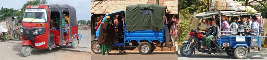
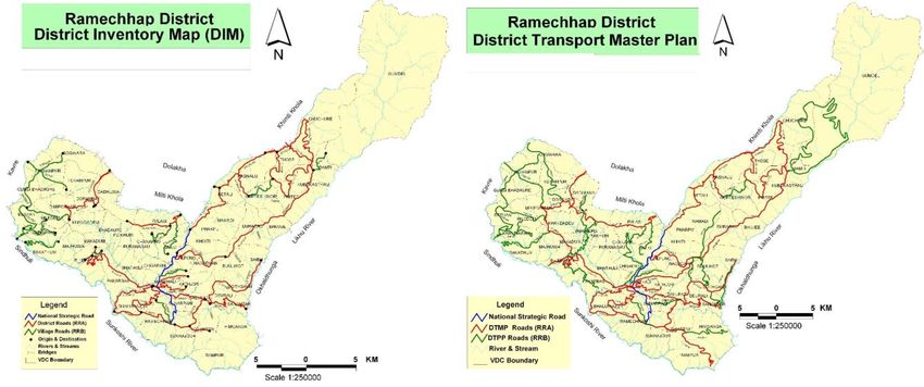
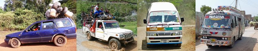
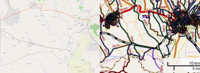
Tables and Figures
Table 1 Four categories of land access infrastructure ...................................................................................................... 19
Table 2 Considerations for planning rural road surface type suitable for transport services .......................................... 27
Table 3 Considerations for planning drainage on rural roads .......................................................................................... 28
Table 4 Considerations for designing the geometry of rural roads .................................................................................. 30

Figure 1 Diagrammatic illustration of the provision-preservations-services continuum ................................................... 2
Figure 2 Simplied flow-chart illustrating some of the district-level activies proposed ...................................................... 9
Figure 3 Examples of source maps from Tanzania providing the starting points for local planning maps....................... 15
Figure 4 Two schematic planning maps from Tanzania showing key roads, villages and destinations ............................ 16
Figure 5 Two maps from Tanzania showing rural transport services operating to/from two different hubs .................. 16
Figure 6 Example of map showing on-road and off-road villages in Liberia with motorcycle trail connections .............. 17
Figure 7 Example of OpenStreetMap map for a small rural area in Tanzania showing infrastructure categories ........... 18
Figure 8 Example from Nepal of the development of a District Transport Master Plan map .......................................... 18
Figure 9 Example of RAI calculation map showing population density and all-season roads with a 2 km buffer ............ 24
Figure 10 Examples of constructed motorcycle trails ....................................................................................................... 31
Figure 11 Examples of trail bridges useable by pedestrians and motorcycles ................................................................. 31
Figure 12 Schematic flow diagram summarising key steps in the adoption of an integrated approach .......................... 41
Figure 13 A long chassis bus, a short chassis bus and a passenger truck ......................................................................... 49
Figure 14 Examples of a rural taxi, pickup/jeep, minibus and midibus used on LVRRs .................................................... 49
Figure 15 An autorickshaw and motorcycle three-wheelers supplying route-based services ......................................... 49
Figure 16 Motorcycles and motorcycle taxis .................................................................................................................... 50
Figure 17 Conceptual model of a segment from a regional transport hub system .......................................................... 51

IMPARTS: GEN2136A iv Guidelines

Abstract
These guidelines are provided to assist rural road authorities and the agencies with responsibility for rural
roads to collaborate with the departments charged with regulating transport services and local authorities
in order to provide and maintain roads fit-for-purpose for the prevailing transport services. The guidelines
derive from the ‘Interactions: Maintenance-Provision of Access for Rural Transport Services (IMPARTS)’
project funded by UK Aid, which examined how investments in low-volume rural road (LVRR) construction
(provision) and maintenance (preservation) affect rural transport services (RTS). Improved RTS are vital for
enabling access to facilities including markets, health centres, education and socio-economic opportunities.
A summary is provided of the main RTS types and their operational characteristics. While road investments
are often justified by envisaged RTS improvements, few road authorities have collected RTS information.
An integrated and devolved institutional approach is recommended with the authorities responsible for
roads provision and transport services working with district authority staff of several disciplines and
consulting with transport services operators and a diverse range of rural people.
In the guidelines, participatory processes are advocated to develop district transport master plans,
highlighting priority roads and off-road villages requiring motorcycle trails to reach the road network.
Various maps are suggested to facilitate understanding and planning. Some relevant indicators are the
Rural Transport Premium (RTP) and the Rural Access Index (RAI). Options relating to road design are
proposed noting their implications for costs and transport services. The importance of maintenance is
stressed. Options for improving rural transport services are suggested, including ways of increasing
predictability and consolidating demand when few people travel. Various available resources are
highlighted to assist planning and prioritisation processes, determining appropriate infrastructure design
choices and understanding rural transport services options and safety issues.

Key words
Road planning; Transport services; Rural mobility; Motorcycle trails; Rural road outcomes; Rural road
impacts; Rural road preservation; Rural road provision

 Research for Community Access Partnership (ReCAP)
 Safe and sustainable transport for rural communities
 ReCAP is a research programme, funded by UK Aid, with the aim of promoting safe and sustainable
 transport for rural communities in Africa and Asia. ReCAP comprises the Africa Community Access
 Partnership (AfCAP) and the Asia Community Access Partnership (AsCAP). These partnerships support
 knowledge sharing between participating countries in order to enhance the uptake of low cost, proven
 solutions for rural access that maximise the use of local resources. The ReCAP programme is managed by
 Cardno Emerging Markets (UK) Ltd.
 www.research4cap.org

IMPARTS: GEN2136A v Guidelines
Acronyms and Units
4x4 Four Wheel Drive m Metre
AfCAP Africa Community Access Partnership MCA Multi-Criteria Analysis
ADB Asian Development Bank NGO Non-Governmental Organisation
CBO Community Based Organisation NPV Net Present Value
DDC District Development Committee ORN Overseas Road Note
DFID Department for International Pax Passengers
 Development, UK PIARC World Road Association
DoLI Department of Local Infrastructure PMU Project Management Unit
DoLIDAR Department of Local Infrastructure RAI Rural Access Index
 Development and Agricultural Roads RAMS Road Asset Management Systems
DRCC District Roads Coordination Committee ReCAP Research for Community Access
DROMAS2 Road database in Tanzania Partnership
DTMP District Transport Master Plan RED Roads Economic Decision model
e.g. For example RTP Rural Transport Premium
GIS Geographic Information System RTS Rural Transport Services
GPRTU Ghana Private Road Transport Union SDG Sustainable Development Goal
GPS Global Positioning System SEACAP South East Asia Community Access
h Hour Programme
HDM-4 Highway Development and Management SSA Sub-Saharan Africa
 Model version 4 SSATP Sub-Saharan Africa Transport Policy
ILO International Labour Office/Organisation Program
IMPARTS Interactions: Maintenance-Provision of SuM4All Sustainable Mobility for All (World Bank,
 Access for Rural Transport Services Washington DC)
IMT Intermediate Means of Transport TP Technical Panel
IRMH International Road Maintenance Handbook TRL Transport Research Laboratory
IRAP Integrated Rural Accessibility Planning UK United Kingdom
IRI International Roughness Index UKAid United Kingdom Aid (Department for
IRR Internal Rate of return International Development, UK)
k thousand USD United States Dollar
kg Kilogram USDc United States Dollar cents
km Kilometre VAT Value Added Tax
Ksh Kenya Shilling VDC Village Development Committee
LVRR Low-Volume Rural Road VOC Vehicle Operating Costs
LVS Low Volume Seal WIDP Woreda Integrated Development Plan

IMPARTS: GEN2136A vi Guidelines
1 Introduction to these Guidelines
1.1 Research project context
The Research for Community Access Partnership (ReCAP), funded by UKAid, commissioned TRL to
undertake a research study to gain, and to disseminate, a greater understanding of how investments in
low-volume rural roads (LVRRs) impact rural transport services and the mobility of people and their goods.
This project was known as IMPARTS (Interactions: Maintenance-Provision of Access for Rural Transport
Services). It explored the interaction between the effective use of rural access and its dependency on the
appropriate provision and preservation of LVRRs, and the resultant changes in rural transport service
provision that are brought about through improved sustainable road performance. A diagram illustrating
the continuum of infrastructure provision, its preservation (maintenance) and transport services is shown
in Figure 1. These guidelines derive from the IMPARTS research project and are based on literature reviews
relating to rural infrastructure and transport services, surveys undertaken in Nepal and Tanzania and
stakeholder consultations. Full details of the research activities and findings are provided in a series of
reports that form the basis of these guidelines (Starkey and Hine, 2020; Starkey et al., 2019a, 2019b, 2019c,
2020b, 2020c and 2020d).
 Figure 1 Diagrammatic illustration of the provision-preservations-services continuum

 Provision Preservation
 of infrastructure
 of roads and
 through
 motorcycle trails
 maintenance

 Appropriate
 transport
 Services

1.2 Target audience
The guidelines are intended to assist professionals in rural roads agencies and in the authorities responsible
for rural transport as well as officials within devolved administrations concerned with improving rural
transport. The guidelines should also be useful for policy makers in the ministries, departments and
authorities responsible for planning, rural roads, transport regulation and road safety. They are primarily
intended for use in low- and middle-income countries in Africa, Asia, Latin America, the Caribbean and the
Pacific although some of the issues raised will be relevant elsewhere.

1.3 Guideline structure
Section Error! Reference source not found. introduces these guidelines and how they have been
developed.
Section 2 provides guidelines for achieving informed decision making on the local priorities for rural roads
and trails and their anticipated transport services. This section is at the heart of these guidelines.
Section 3 discusses the design options for different categories of rural transport infrastructure that may be
appropriate to different types and volumes of transport services.

IMPARTS: GEN2136A 2 Guidelines
Section 4 discusses related maintenance issues and options to ensure investments in road infrastructure
are preserved at affordable costs.
Section 5 presents some options for improving the transport services and their regulation, including road
safety issues.
The concluding Section 6 points to further information sources and possible ways forward.
Annex 1 provides additional background about the need for, and the benefits of, rural transport services
with examples of the types of rural transport services and ways in which they are organised and regulated.
Annex 2 provides additional examples relating to planning road investments and examples of how data
collection can illustrate changes to transport services resulting from such investments.

1.4 Context and understanding
Through the IMPARTS research project, other professional assignments and published literature, the
authors are familiar with rural road and transport services issues in numerous countries worldwide. They
are convinced that the approach to planning rural roads and transport services presented in these
guidelines will prove beneficial. Their gradual implementation should help eliminate some costly
misjudgements concerning road investments and, over time, improve rural transport services.
While there are examples of elements of these guidelines that have been successfully adopted by projects
and institutions around the world, there are no clear examples where organisations have incorporated all
the recommended practices presented here, as part of a replicable strategy. These guidelines are derived
from the experiences of many different countries, but there is no perfect solution. All decisions will have to
be based on some forms of compromise, to ensure transport infrastructure provision and transport services
can be affordable and readily available to rural women, men and children.
One key issue to stress from the outset, is that while there are many similarities in the ways rural transport
services operate around the world, each country is unique. There can be important differences between
regions within the same country. The best way forward in each country will depend on numerous
interacting local factors, including geographical characteristics, socio-economic conditions and governance
structures. The intention of these guidelines is not to be prescriptive, but to offer potential options and
ways forward.
All options, whether related to transport services types or infrastructure specifications, are compromises
between affordability and quality. Rural people and government decision makers aspire to high quality
options. The financial reality often means that limited budgets can go further, benefitting more people, if
implemented standards are below the best quality option. Such compromises are inevitable but are
sensitive and depend on local circumstances. These guidelines are not intended to be prescriptive as to the
standards to employ but are meant to assist decision-makers in keeping transport provision affordable.
Discussions on transport services options, and photographic illustrations of these, include issues that
appear to be sub-optimum and possibly dangerous. For example, it is universally illegal to overload
transport services vehicles, including motorcycles. These guidelines are not in any way condoning poor
practices or dangerous transport services. The examples given are all based on current practices in some
countries, and there is discussion on ways of improving local enforcement, mindful that the highest
standards may limit people’s access to transport, possibly leading to worse outcomes for rural people.

1.5 Options for interventions, a piloting approach and the sharing of experiences
These guidelines provide options that, if implemented within the context of existing planning and data
collection frameworks, should lead to rural infrastructure and rural transport services that are appropriate
to the needs of rural communities. Not all options will be appropriate in all circumstances: the guidelines
offer a menu of options, allowing people and organisations to select those considered most suitable for
their local circumstances.
The emphasis of these guidelines is on actions at a devolved level. It is suggested that implementing
organisations should trial data collection, local transport planning and initiatives for improving transport

IMPARTS: GEN2136A 3 Guidelines
services in particular districts and build upon the positive experiences gained (and address any problems
encountered). The lessons can be shared with other districts through workshops and exchange visits, to
initiate a snowballing effect of increasing adoption based on local experiences and best practices.
Implementing organisations are also strongly encouraged to share their experiences with other countries.
The authors would be grateful to receive feedback on the experiences of pilot implementations as would
the commissioning organisation, ReCAP.

IMPARTS: GEN2136A 4 Guidelines
2 Planning Rural Access Suitable For Rural Transport Services 2.1 Overall goal of rural access and mobility at affordable community costs 2.1.1 Overall goal and key guidelines The goal of universal rural access and mobility is embedded in the Sustainable Development Goal (SDG) target 9.1: “Develop quality, reliable, sustainable, and resilient infrastructure, including regional and trans- border infrastructure, to support economic development and human well-being, with a focus on affordable and equitable access for all.” (UN, 2015) The Sustainable Mobility for All (SuM4All) initiative provided the following four guidelines to help to achieve rural access under the SDG target 9.1 (SuM4All, 2019). Access should be provided for all people. Access should be affordable and equitable. Infrastructure should support economic development and human well-being. Infrastructure should be quality, reliable, sustainable, and resilient. A more comprehensive list of guidelines was identified in the United Nations 10th Environmentally Sustainable Transport Forum in Asia in 2017, held in Vientiane, Lao. It is referred to as the Vientiane Declaration on Sustainable Rural Transport (UNCRD, 2017). Promote inclusive, affordable, accessible and sustainable rural transport infrastructure and services. Improve access to basic utilities and services including health and education by the rural poor, farmers, agricultural workers, girls and women, youth, and physically disabled and vulnerable groups. Improve investments in new rural roads and ensure adequate maintenance of rural roads. Explore climate adaptive road and infrastructure investments in rural areas to enhance resilience of local communities. Promote environmentally sustainable transport in rural areas by introducing low-carbon transport system and avoiding road development without environmental consideration. Improve rural transport connectivity to wider local, national and regional transport networks. Improve transport safety, sustainability and efficiency in rural areas. Explore innovative solutions to improve rural-urban connectivity; to improve and green supply chain logistics (from producers to consumers); to achieve safe and sustainable rural access; to achieve resource and energy efficiency in rural transport services; and to reduce local air and water pollution as well as mitigate, and adapt to climate change. A diversity of possible actions has been identified. There is clear emphasis on inclusivity and leaving no one behind. There is need to consider all rural people, whatever their ethnicity, status, gender, wealth, age or ability. Services need to be affordable (i.e. provided at minimum cost to the users) and general welfare and safety need to be considered. This provides an overall context for rural transport policy and planning. 2.1.2 Key outcome objective: minimisation of community transport costs within a district In order to meet the goal of rural access and mobility and provide guidance relating to both infrastructure and transport service interventions, a useful outcome objective is the ‘minimisation of community transport costs’ for any proposed level of intervention. Funds are limited for the support of both infrastructure and services, so, in order to get the best outcome for the funds spent, the objective may also be expressed in terms of ranking interventions in terms of the following ratio: Reduction in community transport costs / Associated intervention costs To achieve the lowest level of community transport costs for a given budget, the interventions with the highest ratios should be the selected in turn, until the total intervention budget is exhausted. IMPARTS: GEN2136A 5 Guidelines
Community transport costs can be defined as the total combination of passenger fares, freight tariffs,
running costs of not-for hire vehicles and unpaid personal travel time. If an intervention is planned then
transport costs, fares and tariffs, may be expected to change both because operating costs (and fares and
tariffs) of particular modes may change, because the road surface is in a better condition, or the journey
distance is shorter, or there is a switch in modal composition. This is a local approach (e.g. district based) to
ensure the travel needs of rural people are met at minimum cost to household resources. With this
approach, data would be required on passenger and freight tariffs and travel times. It would be necessary
to include value of personal travel time, personal freight transport (such as headloading), and the direct
running costs of vehicles used for personal and household use (such as bicycles, motorcycles and cars).
Examples of transport costs, fares and tariffs, together with key road engineering characteristics that affect
modal composition are included in Annex 2. The use of the Road Economic Decision Model (RED) to help
predict vehicle operating costs, based on road condition is also discussed in Annex 2.
While the guidance of the SDG processes, SuM4All and the Vientiane Declaration point towards the
outcome objective of minimising community transport costs within districts, no formalised process has yet
been devised to assess and model these costs in a consistent way. Further research is required to develop
and test modelling procedures. If there is available data on fares and tariffs it may be possible to develop
spreadsheet models to compare different scenarios. There are also some simple indicators that can be
readily obtained, such as the Rural Transport Premium, defined as the ratio of rural transport fares
compared with long distance transport fares expressed on a per passenger-km basis (see Section 4.7.3),
that can assist as partial proxies for community transport costs. In the short-to-medium term, it is
envisaged that roads authorities will continue using conventional tools for comparing investment options.

2.2 Existing planning procedures and economic models
Within a District there are likely to be a range of rural transport infrastructure options that may be
considered for investment. For rural road planning a range of tools are used, and many countries already
have clear guidance on the use of these. Tools include Ranking (often referred to as Cost-Effectiveness
Criteria) and Cost Benefit Analysis using models such as the Road Economic Decision Model (RED) and the
Highway Development and Management Model (HDM-4). Multi-Criteria Analyses (MCA) are also used that
combine and rank a range of different criteria. RED and HDM-4 may be used to help predict the change in
‘community transport costs’ for different road investment interventions. The procedures vary in terms of
their data requirements and relative complexity. RED and HDM-4 estimate underlying vehicle operating
costs according to road condition. They also adopt economic discounting over the lifetime of the road
investment and hence can help analyse the effect of different maintenance alternatives and budget
scenarios, while ranking procedures adopt more simple comparisons of road investments at the same time.
Where traffic volumes are low and vehicle access is prevented during the wet season, or being introduced
for the first time, Ranking or simple Cost-Effectiveness Criteria can be particularly useful tools. RED and
HDM-4 may be used when a formal economic analysis is required, particularly to meet donor requirements.
RED is a relatively easy-to-use spreadsheet-based model that is mainly used when traffic volumes range
between 50 and 300 conventional vehicles per day. HDM-4 is a more complex model that requires
specialist training and is mostly used for roads with higher traffic volumes. It can also be used to test and
refine a wide range different road engineering designs. Further information on the different approaches is
included in Annex 2, and a more detailed discussion of different planning criteria is available in a World
Bank document on ‘Planning infrastructure and services’ (Hine, 2014).
The guidelines presented in this document provide a framework for district-level planning that allows
information to be gathered from many different sources, participatory discussions of the issues and joint
analyses of the likely effects of road investments on rural transport services and people’s mobility.
Economic analyses, using any of the tools mentioned according to local requirements, can be performed as
part of the planning processes. However, it is strongly recommended that the final results are discussed
with the stakeholders to allow the ‘common-sense’ of transport operators and users to challenge dubious
modelling results. None of the modelling systems is perfect, with various assumptions and biases being
introduced as the data is manipulated.

IMPARTS: GEN2136A 6 Guidelines
2.3 Institutional Arrangements 2.3.1 The current situation Planning and regulating transport services is generally the responsibility of a separate ministry or department. These ministries or departments tend to be small, and concentrate on administrative matters (licensing, testing, taxing) and regulating urban and inter-urban transport. This is discussed further in Annex Error! Reference source not found.. Due to the small size of their administrations, they are seldom represented by many senior personnel at district level. If they are, the main tasks of the devolved staff generally relate to administrative compliance and not to planning transport services. Partly for this reason, very little proactive planning of transport services takes place at district level. District councils may be delegated the responsibility of issuing route licences for certain types of conventional transport services. The initiative to request such licenses generally comes from the operators themselves. Currently, it is most unusual for transport authorities to develop master plans of how they would like to see the different types of transport services improve their coverage of possible routes. Most of the transport services operating on LVRRs are informal sector operators, frequently operating beyond regulatory scrutiny and often being non- compliant with national regulations. Few, if any, transport services regulating authorities have data on the numbers of vehicles operating on LVRRs and the tariffs they actually charge. While districts often have a planning officer whose work spans many disciplines, it is most unusual that such planners regularly collect data on transport services, tariffs or even traffic flows. These guidelines intend to assist the transport services authorities, the roads agencies and the district authorities to work with local transport operators and proactively develop local transport plans, covering roads, trails and transport services. Currently, the staff of roads authorities have little or no training relating to transport services and may feel uncomfortable talking to transport services operators and/or collecting data on transport services as this is not perceived as their responsibility. Transport services regulatory staff are not generally available at a district level to provide the data on rural transport services required for road planning. Given there is a recognised need to have an integrated approach to providing rural roads and transport services, some forms of modified institutional arrangements are required, so that acting together, integrated plans can be developed. 2.3.2 Suggested new approaches As each country will have different institutional systems and priorities, the following suggested approaches are offered as possible ways of improving the integration of road infrastructure planning and transport services planning and/or increasing collaboration in the processes. Combine or integrate the ministries/departments responsible for roads and transport services at a national level. Delegate administrative processes relating to licensing, testing and taxation to a specialised agency to free the transport services regulatory staff to concentrate on planning and improving transport services. Allow and encourage district-level staff of rural roads authorities to engage with, and obtain data from, transport services on the LVRRs for which they have responsibility. Provide training relating to understanding rural transport services, their operational systems and key data to collect for district level planning officers and to district staff responsible for planning rural roads and transport services. Consider establishing a specialised unit, or delegating existing staff, to facilitate district level integrated approaches to planning rural roads and transport services and to provide training in the processes and the data collection methods. Establish a specialised unit in the ‘roads and transport’ authority (or the roads authority) to tackle the specific issues relating to increased motorcycle use (and other IMTs), including the design and construction of low-cost infrastructure such as motorcycle trails and trail bridges. Provide training to district-level staff about the specific issues relating to increased motorcycle use (and other IMTs) on LVRRs and the benefits and practicalities of constructing motorcycle trails and trail bridges. IMPARTS: GEN2136A 7 Guidelines
2.4 District level planning

2.4.1 An overview of the proposed approach
These guidelines are advocating a devolved approach to planning rural roads and transport services. This
document refers to ‘district-level planning’ but this can be interpreted according to the specific hierarchies
of devolved government in the implementing countries. Reference to planning at ‘county-level’,
‘municipality-level’ or ‘commune-level’ (francophone countries) may be more appropriate in some
countries. Working at the devolved level provides opportunities to directly involve rural communities and
rural transport operators in the planning and development of rural transport. Multi-disciplinary district-
level planning is not new and has long been used by district-level development projects and initiatives. It
has already been systematically established in many countries, with varying degrees of consistency and
continuity. Examples are given in Section 0.
The approach involves the relevant road authorities/agencies, the transport services authorities and the
district councils cooperating at district level. They will develop processes to consult with key stakeholders
including rural communities and transport services operators. Specific mention is not made here of the
special interest of schools, health facilities, agricultural enterprises and other key services as the
institutional interests are assumed to be represented through the district authorities and the various user
interests should be voiced by the rural communities. Similarly, it is assumed that the district councils and
communities will use the processes to help address the special needs of women, young people, people with
disabilities and disadvantaged groups.
In the following sections, some steps involved in the consultation and planning processes are
recommended. These include understanding local transport hub-and-spoke patterns, preparing various
maps in collaboration with the transport operators and the rural communities and collecting the required
data. There should be discussion on people’s priorities for roads and motorcycle trails and suitable options
for improving existing transport services. Some of the various district-level activities are summarised in a
simplified flow chart in Figure 2. How these activities could fit into the development of a national strategy
are summarised in Figure 12 at the end of this document.

2.4.2 A first step: form a District Transport Master Plan Coordinating Committee
The DTMP planning process will involve several institutions and many stakeholders. One of the first steps
will be to form a committee (or other coordination system) that will oversee the processes, delegate
specific tasks and ensure the quality and timeliness of the various tasks and outputs. The composition of
the DTPM committee will depend on local circumstances and organisational structures. It is likely to be
chaired by a senior representative of the district authority although someone from the roads’
authority/agency might assist with this. It is likely to include representatives of district level specialised
departments (planning, transport, health, education, agriculture, environment, women’s concerns, etc.).
The road’s authority/agency may be represented at district level and possibly at national/provincial level as
well. The transport services authority would also be represented at district level and/or at
national/provincial level. Depending on local circumstances, transport operators could be represented, as
could influential development NGOs/CBOs.
At an early stage, one of the main tasks would be to prepare a list of the key activities required and to
delegate responsibilities for implementing and for monitoring these. Many of the infrastructure-related
surveys and data collection might be delegated to staff from the roads’ authority/agency. It may be
appropriate to engage consultants or interested NGOs to undertake some tasks. Local NGOs may be
valuable for assisting with the stakeholder discussions with local communities, however the road engineers
and those responsible for transport services should also engage with some of these consultations to learn
more about local problems and priorities.
In the following sections, various recommended activities will be described. It will be assumed that the
DTMP Coordinating Committee will assign the related implementation responsibilities to appropriate
individuals or organisations.

IMPARTS: GEN2136A 8 Guidelines
Figure 2 Simplied flow-chart illustrating some of the district-level activies proposed

 Roads
 Authorities
 District Transport
 Council Authorities

 Transport services Consult local Rural
 operators stakeholders, form communities
 committee

 Visit district, Prepare maps,
 hold meetings data surveys

 Identify remote
 areas, critical links
 District
 level
 Review
 maintenance
 tasks

 Survey of proposed routes,
 prepare cost estimates

 Economic analysis and
 prioritisation

 Identify solutions to improve
 transport services

 Undertake pilot
 interventions

IMPARTS: GEN2136A 9 Guidelines
2.4.3 Examples of district level planning of roads and transport services
In Ethiopia, the local districts are known as Woredas, and under the Ethiopian Rural Travel and Transport
Programme a multi-disciplinary, district-based planning process was widely implemented, generating many
Woreda Integrated Development Plans. These included important non-transport infrastructure (relating to
health, education and agriculture) and schemes to promote the use of intermediate means of transport
(including bicycles, animal-drawn carts and three-wheelers). A summary of some of the processes and
issues is provided in Box 1.

 Box 1 The Woreda Integrated Development Plans undertaken in Ethiopia
 Under the Ethiopian Rural Travel and Transport Programme a series of district (Woreda) development plans were
 developed using accessibility as a key tool to integrate the various components. The programme was administered
 by the Ethiopian Roads Authority but with representation of other ministries. Initially a series of manuals were
 produced covering planning, rural transport infrastructure, transport services, non-transport interventions and
 income generation and resource mobilisation and management. In 2001, eight pilot Woreda Integrated
 Development Plans (WIDPs) were produced.

 It was recognised that, in view of the diversity of Woreda characteristics a ‘one-size-fits-all’ approach would not be
 appropriate. By 2008, 130 WIDPs had been prepared or were under preparation. The plans produced were
 comprehensive, covering significant investments in agriculture, health, education, as well as transport infrastructure
 and Intermediate Means of Transport (IMT). Implementation of each plan was the responsibility of the Woreda
 officials, with the roads desk responsible for overall coordination. A wide range of planning procedures were adopted,
 including IRAP, transport cost-benefit analysis and conventional financial accounting approaches.

 An assessment of the implementation of the eight pilot WIDPs, in relation to the transport related components, was
 carried out in 2008. The assessment found significant improvements in both accessibility and socio-economic
 conditions resulting from road investments (of varying standards), provision of IMTs, and increased provision of
 facilities such as health posts and schools.

 Source: IT Transport, 2008.

Since the 1990s, a district level planning approach has been developed and used by the rural roads
authority in Nepal. This approach led to the systematic preparation of District Transport Master Plans
(DTMPs). The processes are summarised in Box 2.

IMPARTS: GEN2136A 10 Guidelines
Box 2 District Transport Master Plan process in Nepal
The District Transport Master Plan (DTMP) process in Nepal provides a good example of a widely-implemented,
inclusive, bottom-up approach to planning road network development. The objective of a DTMP is to facilitate and
prioritise district roads over a five-year period, to support the development of a sustainable road network that
reduces aggregate transportation cost and minimises environmental impacts. The DTMP process was introduced to
minimise ad-hoc practices of investing in roads based on short-term considerations and political contingency. The
DTMP provides a fundamental base for planning and implementing new construction and upgrading existing district
roads, with the aim of providing the basis for a process of sustained growth.
A key tenet of the DTMP process is the participatory approach of public consultation with local authorities, involving
all important stakeholders at crucial stages of the planning process. A crucial process is the formation of a District
Roads Coordination Committee (DRCC), initiated by the Chairperson of the District Development Council (DDC). This
ensures participation of the district in the entire planning, decision-making, programming and implementation
process. The DRCC coordinates the local planning and construction of roads, trails and trail bridges.
Following the formation of a DRCC, general field surveys are carried out to develop a better understanding of the
socio-economic conditions and priorities, related to access to services, trading routes, agricultural production,
development potential and an inventory of existing roads and trails. When this is complete, the information is
plotted on available maps to create a thematic map of transport infrastructure and district location at the national
level, and the district road inventory. The data collected from field surveys is used to identify potential areas for
investments in roads. This provides the basis for further discussions with the DRCC to identify roads for detailed
study in the district. At this stage regional synchronisation is considered by identifying roads that could benefit more
than one district. An indicative development potential map of the district is then prepared.
Local workshops are held to record the requirements of local people for transport connectivity. This is carried out in
the presence of Village Development Committee (VDC) secretaries, local key informants, social workers,
representatives of local political parties, women and disadvantaged groups, and representatives of NGOs and CBOs.
The preliminary demand for transportation is collected from meetings of the VDC, where the basic transport
requirements for that village are discussed.
After a good understanding of the district situation has been established, the DRCC discusses the investment in
roads and identifies the priority roads to be proposed to the DDC for new construction and rehabilitation. Once the
roads have been identified the environmental impacts and mitigation strategy is considered. The local engineer
carries out a detailed socio-economic survey and engineering feasibility study of the proposed corridors. An
estimate is prepared to identify the rehabilitation or construction costs for each road.
The next step is to analyse all the factors used to prioritise roads, such as demography, agricultural potential,
market/service centres, traffic flows, social and engineering aspects and special considerations such as religious and
tourist sites. A weighted scoring system is developed. Each road is assessed, and the results are discussed with the
district officials. The prioritisation is decided transparently in the context of available resources for each district.
A draft DTMP is produced and distributed to all VDCs for their information and consideration. When VDC feedback is
complete and any adjustments have been made, the draft DTMP is presented to the DDC for approval. This part of
the process should involve as many stakeholders as possible, including local politicians, line agencies and members
of parliament. When final approval is received from the DDC, the DTMP is presented to the Department for Local
Infrastructure and the National Planning Commission. Many examples of District Transport Master Plans can be seen
on the website of the rural roads’ authority in Nepal (DoLI, 2020).
In addition to the DTMPs, districts in Nepal also worked with their neighbouring clusters of districts to produce
District Transport Perspective Plans. These considered travel between districts and to reach national destinations to
ensure there were synergies of provision and no unnecessary duplication of key routes.
Note: the DTMP process did not explicitly refer to including rural transport services operators in discussions. By
involving village-level stakeholders, issues relating to rural transport services constraints could be raised. The authors
of these IMPARTS guidelines recommend that specific mention is made of involving transport services operators.
 Source: DoLIDAR, 2012.

An entire methodology for participatory planning of access and mobility at a devolved level was developed
by the International Labour Office (ILO) and other organisations. The ILO process was known as Integrated
Rural Accessibility Planning (IRAP) and large numbers of documents and resources are available to assist
with this process. The development of these and other ideas is summarised in Box 3.

IMPARTS: GEN2136A 11 Guidelines
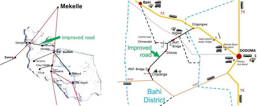
Box 1 Integrated Rural Accessibility Planning (IRAP) and other integrated approaches In the 1980s and 1990s, the International Labour Office (ILO), with the support of Swiss Development Cooperation and other agencies, was working on labour-based approaches to road construction. ILO was concerned that conventional rural road planning was not sufficiently integrated with the wider issues of poverty reduction and rural development. An important early output was the ILO publication ‘Rural transport in developing countries’, stressing the importance not only of roads but also IMTs and technologies to reduce headloading (Barwell et al., 1985). Other collaborating organisations, including the Intermediate Technology Development Group, agreed with this approach. Through various collaborative initiatives, this led to the creation of the International Forum for Rural Transport and Development (IFRTD) and the formation of the IT Transport consultancy, both of which were strong advocates of multidisciplinary integrated approaches. The Makete Integrated Rural Transport Programme in Tanzania (1985-1996) proved particularly important in recording and publicising links between rural poverty and transport, and influencing national and international policies (Lema, 2007). This project was before the days of widespread motorcycle use, so there was no emphasis on these, but in addition to road construction, work was carried out on village trails and the use of donkeys. A second influential publication was ‘Roads are not enough: new perspectives on rural transport planning in developing countries’ (Dawson and Barwell, 1993). The integrated approach was taken up and further developed by the Sub-Saharan Africa Transport Policy Program (SSATP) hosted by the World Bank (Malmberg Calvo, 1994 and 1998; Ellis and Hine, 1998; Lebo and Schelling, 2001; Starkey, 2001; Starkey et al, 2002; Starkey, 2007a and 2007b; Banjo et al., 2012; Hine, 2014). The pioneering accessibility planning work of ILO was developed into a clear methodology know as Integrated Rural Accessibility Planning (IRAP). This was trialled in the Philippines, Malawi, Cambodia and other countries, and numerous valuable reports and training resources were produced that are still extremely valid and helpful today (Dingen, 2000; Donnges, 2003; van Dissel, 2003; ASIST AP, 2004). Multidisciplinary teams would work with villagers and discuss and map possible transport investments such as roads, footpaths and trail bridges as well as non-transport investments such agricultural stores, schools, clinics, wells, woodlots, electricity supplies. The various options and priorities are discussed with stakeholders and with personal travel time a key criterion. A similar approach was applied to district level access and facilities, and this was used in Cambodia, in association with labour-based construction methodologies (Rozemuller et al., 2002a and 2002b). While there is much information available on participatory and inter-disciplinary planning methodologies available, these methods have not yet been fully ‘mainstreamed’ into roads agencies. There has been a tendency within national roads authorities, and in donor agencies, for engineers to work in professional ‘silos’, concentrating only on engineering issues. Work for roads authorities (and supporting donor agencies) on evaluating road impacts, transport services and rural mobility has often been delegated to social scientists, universities and consultancies. The institutional environments did not favour multi- disciplinary approaches. Even during the initial years of the first phase of AFCAP, there was no work relating to transport services and there was serious opposition to AFCAP adopting an integrated approach. However, from the outset, ReCAP adopted a more integrated approach, and has highlighted the importance of the provision-preservation-services continuum that was illustrated in Figure 1. These guidelines are designed to promote that integrated approach. Four aspects of the work of the IMPARTS project further highlighted the existing problems that need to be resolved through the more integrated approach being advocated here. From the literature review, it was found that there has been little research on rural transport services. Road impact studies have seldom collected data on transport services (Starkey et al., 2019a). From discussions with road authorities in all ReCAP countries, it was clear that there is no systematic collection of transport services information by roads agencies (Starkey et al., 2019a). From the IMPARTS stakeholder workshop, it was found that participants wanted a more integrated approach and would welcome advice on how to achieve this (Starkey et al., 2019b). IMPARTS: GEN2136A 12 Guidelines
From the IMPARTS field research, examples were shown of road investments that were made without sufficiently consulting local residents and transport services operators, leading to some inappropriate investments (Starkey et al., 2020c and 2020d). Another reason for the lack of uptake of district-level planning includes its time-consuming nature, and the high degree of devolved responsibility required. Much district level planning of rural transport interventions has been carried out with ear-marked funding provided by donor-assisted projects. In the cases of Ethiopia mentioned in Box 1 and Malawi and Cambodia mentioned in Box 3, extra personnel were available to assist with the processes. In normal, non-project settings, the national authorities do not have sufficient funding or personnel resources to provide comprehensive additional resources to assist the detailed planning of all districts. For this reason, district-level training will be required, and pilot planning initiatives are recommended in these guidelines. 2.4.4 Understand transport hubs, transport watersheds and national connectivity While the DTMP is prepared at district level, with district stakeholders, it must consider wider transport issues and existing transport hub and spoke systems. Hub and spoke systems are described in Annex 1 and illustrated in Figure 17. The DTMP should not be a ‘district-centric’ plan, concentrating only on internal connectivity. In Nepal, districts have prepared District Transport Perspectives Plans covering several districts to ensure there are synergies and lack of duplication. The district town will probably be the centre of operations for the district council, but many people living in the district may wish to travel to markets and towns outside the district. District boundaries seldom conform to existing transport watersheds: people in various parts of the district, may want improved access to different transport hubs in neighbouring districts. Travel to cities outside the district may be more important to them than travel within the district. Box 4 shows examples from Ethiopia and Tanzania where districts provided high specification roads to improve within-district travel, only to find very little traffic (and no transport services) used the roads. This was because district residents wanted to travel to the nearby city that was outside the district. Within district connectivity could have been assured through roads of a much cheaper standard. Understand and map the hub and spoke patterns within the district and those linking to transport hubs and markets outside the district. Identify key destinations for people within and outside the district and ensure these are served by appropriate rural infrastructure and transport services. Do not over-estimate within district travel requirements and ensure that infrastructure specifications are appropriate to realistic transport demand. 2.4.5 Use participatory methods to work with stakeholders and understand their different priorities In order to develop appropriate DTMPs, it will be necessary to have inter-disciplinary discussions within district administrations and undertake participatory consultations with key stakeholders. Involve all relevant departments in consultations and planning, including planning, roads, transport services, health, education, agriculture, environment, gender, business development. Initiate participatory consultations at grass roots level, including representatives of all relevant stakeholders. Ensure representation of different types of transport users, including women, men, older persons, students, people with disability and all minority groups. Consider the benefits of some within-village meetings. Consider the advantages and disadvantages of holding joint or separate discussions with the various types of transport services providers, and whether discussions will be most open and informative if meetings are held with many operators at or near one of their transport terminals. Be aware that the various types of transport service may have different and competing interests. Their leaders may have vested interests and may not represent all operators. IMPARTS: GEN2136A 13 Guidelines
You can also read