TECHNOLOGY AND PLANNING - THIS ISSUE: OPPI
←
→
Page content transcription
If your browser does not render page correctly, please read the page content below
ISSUE 3 | FALL 2019

                        IDEAS AT THE CROSSROADS OF INSPIRED COMMUNITIES

   THIS ISSUE:
   TECHNOLOGY AND PLANNING
   Planner perspectives on practical
   applications of new technology 23

Technology is the paradigm shift that keeps shifting.

                                                        CANADIAN PUBLICATIONS MAIL | PRODUCT SALES AGREEMENT NO. 40011430
OPPI CONFERENCE 2019
                                                    toronto | october 1–3

                                                    Beanfield Centre, Toronto

                                                    Find more information, including session
                                                    details and registration

Facing change and guiding
Ontario into the next quarter                           ontarioplanners.ca
                                                                        ca
century

CONFERENCE HIGHLIGHTS                               KEYNOTE SPEAKERS
Mobile Workshops: Experience first-hand how new
planning ideas are influencing and creating
communities on planner-guided visits to Toronto     Gregg Lintern, RPP, MCIP
neighbourhoods and project sites.                   Chief Planner for the City of Toronto,
                                                    with a proven track record in
Interactive and Lightning Sessions: Choose from     delivering transformative projects
more than 130 sessions on topics related to our
2019 mega themes — Uneven Growth, Climate
Change and Technology.

Tech Demo Gallery: See the latest and most
innovative design and planning tools live and in    Ramona Pringle
action.                                             Writer, producer, digital journalist, and
                                                    go-to expert on technology, digital
OPPI AGM and Awards Luncheon: This year, we         culture, and creative innovation
will recognize the newest RPPs and those
celebrating their 25th year as RPPs. We will also
take time at our AGM to welcome a new OPPI
President and Council for 2019-2020.
                                                    Mikael Colville-Andersen
                                                    One of the leading global voices in
                                                    urbanism, known for his pioneering
                                                    philosophies about urban planning
                                                    and cycling
          OPPI Student Members qualify
         for a special rate of $25 per day
          or $70 for all three days. Learn          3 days
          more about accredited student             150-plus speakers
          programs and how to become
           an OPPI Student Member at                130-plus interactive educational
                                                    sessions, keynotes, and mobile
             ontarioplanners.ca                     workshops
                                                    Between 700 and 1,000 attendees

                                                    #OPPI19 #BEYOND25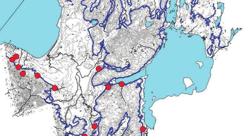
ISSUE 03

                                                                      FEATURES
Y Magazine is published three times                              07   On the matter of technology…
a year by the Ontario Professional Planners
Institute (OPPI).
                                                                 08   Planner perspectives on practical
                                                                      applications of new technology
Publisher, OPPI
Mary Ann Rangam
Robert Fraser
                                                                 13   Using technology to map 13,000
                                                                      years of land use for archaeological
Rob Kirsic
                                                                      management plans
Editor
Carolyn Camilleri                                                15   A bird’s eye view: How Halton is using
                                                                      drone technology
Design
Tenzing Communications Inc.
                                                                 17   The path of least resistance: An
Print Production                                                      approach to achieving better “Cell
Letter Perfect Press                                                  Tower” land use planning outcomes

Digital Production
Seventyeight Digital Inc.
                                                                 19   Scaling up for a start-up ecosystem:
                                                                      A mid-sized city perspective
For advertising inquiries:
finance@ontarioplanners.ca                                        23   Planning, Data, and Technology:
                                                                      What’s new, challenging, and beyond
For feedback and story ideas:
                                                                      our reach?
editor@ontarioplanners.ca

Subscriptions to Y Magazine are available for $75/year +
HST, and you receive both a print and a digital copy of each
issue. Subscriptions to digital-only copies are also available
for $30/year + HST. To learn more about Y Magazine and to
                                                                      REGULARS
subscribe, please visit ontarioplanners.ca.
                                                                 04   Inspire: Extended reality tech
Printed in Canada
ISSN 2562-2900 (Print)
ISSN 2562-2919 (Online)
                                                                 05   President’s Message

Ideas and opinions expressed within Y Magazine do not            30   Celebrating 25 years of RPP:
necessarily reflect the views of OPPI or its affiliates; no             The day planning came of age
official endorsement should be inferred. Y Magazine
contributors are responsible for the accuracy of the
information in their articles and for obtaining permission to
                                                                 32   RPP Profile: Iain Myrans
use source material, if applicable. OPPI does not assume
responsibility for the contents of any advertisement;            34   OPPI News
any and all representations or warranties made in
advertising are those of the advertiser and not the
publisher. No part of Y Magazine may be reproduced,              38   Preview: Winter 2020 Affordable
in all or part, in any form (printed or electronic)                   Housing
without express, written permission from OPPI.

                                                                      ACADEMIC
Cover photo:
                                                                 25   Assessing actual and perceived flood
                                                                      risks to better target public education
Credit: Building Interior, Sidewalk Labs, Snohetta
                                                                      programs
Ontario Professional Planners Institute
201-234 Eglinton Ave. E., Toronto, Ontario M4P 1K5               26   2019 Student Case Competition
T: 416-483-1873 or 1-800-668-1448
E: info@ontarioplanners.ca
W: ontarioplanners.ca

Y MAGAZINE | FALL 2019 | ISSUE 03                                                                                      3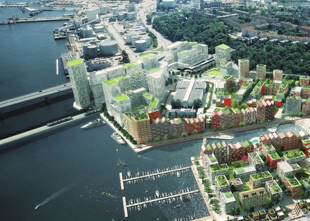
EXTENDED REALITY TECH AS THE NEW NORMAL

                                                       G
                                                             amers have been using extended                “We see enormous potential in these
                                                             reality visualization technology           extended reality technologies for planners
                                                             for years, but what started as             to enhance dialogue with the public and
                                                             entertainment has been evolving            stakeholders as well as for collaboration
                                                       very quickly into a tool for various             between technical experts,” says Boyco.
                                                       industries and professions, including
                                                                                                           Paolo Mazza, GIS specialist with Dillon
                                                       planning. It may not be long before
                                                                                                        Consulting, is currently training planners
                                                       extended reality tech is the new normal.
                                                                                                        and GIS staff in Ontario in how to leverage
                                                          The extended reality realm consists
                                                                                                        VR. He explains that by applying a computer
                                                       of three technologies: virtual reality (VR),
                                                                                                        code to 2-D data, an immersive, smart,
                                                       augmented reality (AR), and mixed
                                                                                                        3-D model can be created.
                                                       reality (MR).
                                                                                                           “Once you have the 3-D models, it’s
                                                          “VR is fully immersive, so you put on
                                                                                                        a matter of one click, and you can get it
                                                       a headset, and it completely blocks out
                                                                                                        into a headset,” says Mazza. “With several
                                                       the outside world,” says Morgan Boyco, a
                                                                                                        more clicks, you can actually bring it into
                                                       Candidate Member of OPPI and a planner
                                                                                                        a video game environment where you have
                                                       and public engagement specialist with
                                                                                                        VR gamification — multiple planners in one
                                                       Dillon Consulting. “AR is where you are
                                                                                                        VR room at a digital table, looking at a
                                                       looking through a screen or device and
                                                                                                        3-D model.”
                                                       you can see what’s surrounding you, but
                                                                                                           The most immersive VR headsets allow for
                                                       there’s a digital overlay.”
                                                                                                        a full range of motion in the digital world, so
                                                          MR is an enhanced form of AR: a more
                                                                                                        you can walk around inside a 3-D city model,
                                                       integrated merger of real and virtual spaces.
                                                                                                        even ducking down to look underneath
                                                       You wear some kind of device to see 3-D
                                                                                                        the street. The response, especially from
                                                       digital images that are integrated into
                                                                                                        younger planners, has been positive.
                                                       and responsive to the real world. AR and
                                                                                                           “Planners are graduating from universities
                                                       MR advancements are ongoing, with both
                                                                                                        with really strong 3-D design and 3-D
                                                       looking exciting in terms of potential uses
                                                                                                        technical skills, so they almost expect it,”
                                                       for planners and urban design professionals,
                                                                                                        says Mazza.
                                                       especially with coming 5G and improvements
                                                                                                           And, perhaps, it’s partly because they grew
                                                       in GPS sensors. But what is really getting
                                                                                                        up in a world where VR is as normal as the
                                                       attention right now is VR, as barriers — cost,
                                                                                                        games they play.
                                                       technical complexity, and practical and
                                                       aesthetic challenges — are being reduced.

Learn more about VR and other tech tools for
planners at the Tech Demo Gallery at the OPPI
Conference 2019 from October 1 to 3. Morgan
Boyco and Paolo Mazza from Dillon Consulting
Limited will be hosting TECH600: Virtual Reality:
The Digital Frontier of Participatory City Building.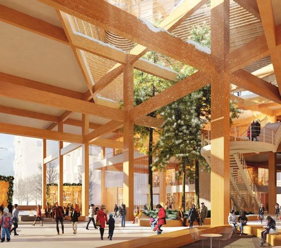
PRESIDENT’S MESSAGE

                            ” Technology has
                      and will continue to
                       influence planning. ”

                        T
                             his influence can be seen in early               As a profession, we also need to
                             post-colonial planning theories like          understand the opportunities that artificial
                             Frank Lloyd Wright’s Broadacre City           intelligence may bring to planning and our
                             concept, where the telephone and              responsibility to uphold the public interest.
                        other technologies facilitated a planned           In the future, artificial intelligence may be
                        decentralization of communities. Instead           used for simple and routine planning tasks.
                        of the telephone, today we talk about the          This isn’t surprising. It is already happening
                        influence of things like computing power           in other professions. Such a change will
                        and the internet of things, which are giving       provide professional planners, known for
                        rise to artificial intelligence. Although          their knowledge, integrity, objectivity, and
                        the technologies have changed, the                 creativity, with opportunities to focus on
                        questions remain the same — how will these         more strategic planning issues that involve
                        technologies influence how we live, work,          competing interests and values and require
                        shop and play?                                     professional judgement.
                           Ontario’s Registered Professional Planners         In this issue of Y Magazine, we look at some
                        are looked to for information on these trends      of the ways technology continues to influence
                        and for their insights into how they will          our work as planners — and how planners are
                        influence our communities in the future. As        using technology to shape our communities.
                        professionals that look at all sides of an issue
                        and provide objective, evidence-based advice,
                        we will continue to inform decision makers on
                        how these changes will influence community
                        character, quality, and competitiveness.
                           Technology will also continue to influence
                        how we plan.
                           Registered Professional Planners will
                        continue to leverage technology and gain
                        access to larger datasets, faster computing
                        speeds, robust analytical models, and
                        visualization tools to inform and communicate
                        their professional opinions. The public,
                        stakeholders, and decision makers will also
                        continue to harness the same technologies
                        to engage in community conversations.                        Jason Ferrigan, RPP
                                                                                     President
                                                                                     Ontario Professional Planners Institute

Y MAGAZINE | FALL 2019 | ISSUE 03                                                                                                         5
FEATURES INTRO

TECHNOLOGY
& PLANNING
                 In this issue of Y Magazine, we look at
                 how technology is being integrated into
                 planning as tools used in the practice
                 of planning, as well as how planners
                 are working to incorporate technology
                 into the communities where they work.
                 To introduce this issue’s theme, Eldon
                 Theodore, RPP, offers his perspective
                 on technology and an approach for
                 planners eager to keep up with the
                 pace of technological change.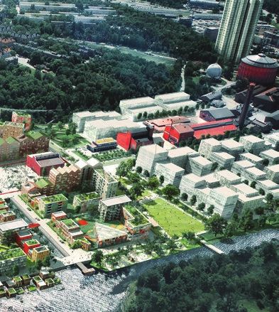
On the matter of technology…
BY ELDON THEODORE, rpp

A
      t the OPPI 2019 Conference on             keeping current, reluctance to try new             Facing change and guiding Ontario into
      October 1 to 3, the theme “Facing         approaches, and three areas of disparity:        the next quarter century — it is a timely
      change and guiding Ontario into           between public and private sector planners,      theme that will explore these questions
      the next quarter century” will place      between smaller and larger organizations,        and others in the advance our knowledge
focus on technology and the role it is          and between urban and rural areas of
playing in the evolution of our profession      Ontario relative to ease of access to            Technology is the paradigm
and our communities.                            infrastructure to support technology.
   Last year, I was part of an OPPI survey      These disparities represent real inequities      shift that keeps shifting.
to help understand our membership’s level       that members face in their work. As land
of experience with technology, how it           use planning benefits from having the best       of technology. To conference attendees, I
influences their practice, where they saw       information, and technology is playing a         encourage you to listen to keynote speaker
it going, their concerns, and their advice      role in enhancing that information, do we        Ramona Pringle offer tools for staying ahead
on how we can stay ahead of the curve.          as OPPI members have a role in helping to        of change. I encourage you to spend some
The feedback was enormous: technology           bridge this divide to achieve technological      time at the Tech Demo Gallery, sharpening
was clearly a top interest for our members.     equity for all planners?                         your skills with the latest tech tools. And
The survey also revealed a number of key           Speaking of the best information, the         I encourage you partake in sessions on
findings I believe our profession should give   drive towards open data is influencing the       matters such as disruption, isolation,
greater attention to and explore.               way we plan our built environment. A lot         engagement, artificial intelligence, and other
   Many members felt our profession’s           of attention has been placed on disruptive       great topics. I look forward to learning from
adoption of emerging technology was slow.       technologies where planners have been            my colleagues, sharing my thoughts, and
For example, when it came to technology         playing catch-up on how best to mitigate         debating these issues.
such as 3-D modelling and printing, drone       existing impacts while making best efforts          Technology is the paradigm shift that
technology, or platforms utilizing augmented    to foresee emerging changes. The rise of         keeps shifting. Recognizing that our
reality or artificial intelligence, our         the smart city concept with developments         communities continue to be transformed by
membership was clearly interested but had       such as Sidewalks Labs is introducing next-      technology, there is an urgency for planners
limited practical experience. Also a general    generation data-driven urbanism that will        to prepare for change and be in a position to
divide between our younger and older            potentially redefine a user’s relationship       lead that change.
members was revealed, in terms of both the      with the built environment. That relationship
breadth of technological knowledge and          represents elements that are visible and
willingness to adopt new tools to advance       invisible to residents, workers, and visitors.
professional work. While this is generally an   As we watch this data-driven urbanism
expected trend between generations, given       unfold, questions about who should own the
the rapid pace of change in technology,         data, who should have rights to access to the
should we take steps to ease our members’       information, and what data should be open
early adoption of emerging technology to        or restricted should be answered quickly.
                                                                                                 Eldon Theodore, rpp, BES, MUDS, MCIp, LED Ap, is
stay ahead of the curve?                        Given this, does planning have an emerging       a member of OPPI and a partner with at MHBC
   Barriers to adopting and accessing new       role in promoting open data urbanism and/        Planning, Urban Design, and Landscape Architecture.
                                                                                                 He is also an OPPI Council Director and Chair of the
technology include cost, the challenge of       or safeguarding the privacy of citizens?
                                                                                                 Community Design Working Group.

Y MAGAZINE | FALL 2019 | ISSUE 03                                                                                                                7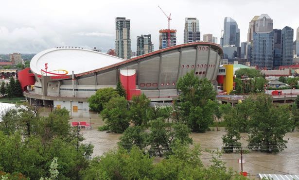
FEATURE                                                                                                   01

          TECHNOLOGY AND PLANNING

          Planner perspectives on
          practical applications of
          technology
          BY CAROLYN CAMILLERI

                              New technology can go from being
                              bewilderingly futuristic to normal life
                              in a very short timeframe. To get their
                              perspectives on the new technology in
                              their projects and plans, Y Magazine
                              talks to three RPPs: Pino Di Mascio,
                              Director of Planning at Sidewalk Labs;
                              Brad Anderson, a Principal Planner for
                              the Region of Durham; and Paul Shaker,
                              a Principal and co-founder of Civicplan.

                      01/02    Sidewalk Labs is an Alphabet company founded in 2015. Quayside, the Sidewalk
                               Labs project in Toronto, is a smart city project that proposes to develop a
                               comprehensive plan that significantly raises the bar on what is achievable.

                                                           Y MAGAZINE
                               Picture Plane for Heatherwick             | SPRING/SUMMER
                                                             Studio / Sidewalk Labs      2019 | ISSUE 02
Picture Plane for Heatherwick Studio / Sidewalk Labs
                                                                                                                                             02

Sidewalk Toronto: A smarter
kind of smart community

T
     he Sidewalk Toronto project,               Di Mascio says have not really succeeded,            “The result will not only be more
     Quayside, is described as precedent        because they did not design with people and       sustainable buildings, but also the growth of
     setting and forward thinking, a new        quality of life first; they created proprietary   a new industry that developers and builders
     kind of development that uses              or closed systems that did not enable others      will benefit from,” says Di Mascio.
technology to address some big urban            to build new solutions, and thus stifled             Streets will be green — significantly
challenges — but not only technology.           innovation; and they assumed technology           improving quantity and quality control for
   What impresses Pino Di Mascio, RPP,          alone would solve tough urban problems, and       stormwater discharge — and dynamic: people
director of planning at Sidewalk Labs and       thus did not think about planning holistically.   focused and pedestrian oriented, with more
previously a partner at Urban Strategies,          “We don’t believe in tech for tech’s sake,”    space for transit, walking, cycling, micro-
is the comprehensiveness of the project.        he says. “For us, emerging technology             mobility, and accessibility requirements,
   “We are tackling relevant and pressing       and good planning and urban design
issues that planners deal with daily — most     are about improving the quality of life           Emerging technology and
notably, improving how people move              in cities — reaching new levels of
around, tackling climate change, building       sustainability, affordability, mobility, and      good planning and urban
environmental resilience, and, most             economic opportunity.”                            design are about improving
importantly to me, doing all this within an        The key to the project’s innovation agenda
inclusive new community that addresses          is a comprehensive set of innovations — not       the quality of life in cities.
social issues and provides affordable           all of which are necessarily digital or based
housing options.”                               on brand new technologies — that together         but with embedded infrastructure for
   To do this, Sidewalk Toronto has proposed    will have meaningful impact while also            technologies such as advanced traffic
a number of specific solutions, including;      allowing others to innovate on top of their       management and AV guidance systems.
establishing a global hub of urban innovation   initial concepts.                                   Other initiatives include an advanced
to spark jobs, growth, and new industries          For example, Sidewalk Toronto is               power grid, including renewable systems
and supporting policy around digital            proposing an entire district made of tall         and a low-voltage distribution system;
infrastructure and data collection in public    timber and pre-fabricated components,             pneumatic waste collection; a district-
and semi-public spaces to ensure privacy        which has required investing significant R&D      based freight delivery system;
and responsible data use.                       to allow architects and engineers to design       non-fossil-fuel heating and cooling; and
   The Sidewalk approach is different from      such buildings and will require investments       open-standards digital infrastructure.
traditional smart cities initiatives, which     into the supply chain and workforce training.       Ultimately, Sidewalk Toronto

Y MAGAZINE | FALL 2019 | ISSUE 03                                                                                                                                            9
innovations will be a catalyst for similar       technologies are utilized in urban planning                                      semi-public spaces raises important public
projects worldwide.                              and development, the public and private                                          policy issues that need to be addressed.
   “If we can help begin to solve some of        sectors can together ensure that the public                                      These issues are diverse and as planners
the problems associated with urban growth        interest is properly addressed.”                                                 are focused on the public interest,
through new technology and good urban               The focus on public interest is where Di                                      our awareness needs to be focused on
planning and design here in Toronto, we          Mascio believes planners beyond Toronto                                          understanding the capabilities of digital
think those lessons can be applicable to         can look to Sidewalk Toronto as an example                                       infrastructure, the appropriate application
cities everywhere with the same problems,”       to learn from. He also believes planners                                         of such infrastructure, and evolving
says Di Mascio, noting that the key is           need to become more literate with regard                                         government requirements around privacy
not to demonstrate that the very same            to technological innovation in general and                                       and responsible data use.”
technologies should be applied everywhere.       the growing public policy regulations around                                        He adds that it is a very different
   “Instead, it is to show that it is possible   data collection and privacy concerns.                                            environment from when started in planning
to create a platform within cities that allows      “The digital revolution has changed                                           25 years ago.
the public sector to work cooperatively          how information can be gathered and                                                 “But if we as planners become more
with a wide variety of groups — innovation       analyzed. This has huge potential to improve                                     technologically literate, we can help the
start-ups, non-profits, local entrepreneurs,     the building and infrastructure systems                                          governments, institutions, non-profits,
and large companies — to apply a variety         we develop and the operations of those                                           and private companies that we work
of ideas that solve important issues,” he        systems,” he says. “But the application                                          with regularly.”
says. “In that way, the expectation is that as   of these technologies in the public and

Connected for success: Durham
Region’s broadband strategy
                                                                                                                            01

                                                                                                                                 H
                                                                                                                                        ow we socialize, how we are entertained,
                                                                                                                                        how we work, and how we access
                                                                                                                                        services and information — these aspects
                                                                                                                                        of life are increasingly moving to online
                                                                                                                                 formats. Consider, too, the effect the internet
                                                                                                                                 has had on retail, as it shifts from brick and
                                                                                                                                 mortar stores to online shopping. A disruption
                                                                                                                                 also seems plausible for how and where
                                                                                                                                 people work.
                                                                                                                                    “We may only be one or two innovations
                                                                                                                                 away from wider corporate acceptance that
                                                                                                                                 would allow tens of thousands of people to
                                                                                                                                 work from home, instead of travelling to a
                                                                                                                                 centralized work place,” says Brad Anderson,
                                                                                        © Regional Municipality of Durham

                                                                                                                                 RPP, a principal planner for the Region of
                                                                                                                                 Durham. “What will this mean for office
                                                                                                                                 buildings and business parks? Or for public
                                                                                                                                 transit and rush hour congestion?
                                                                                                                                    “These examples are just the tip of the
                                                                                                                                 iceberg, but you can already see just how deep
                                                                                                                                 and disruptive the effects can be,” he adds.
                                                                                                                                    It also clearly points to the vital need for
                                                                                                                                 high-speed internet — a need revealed to
                                                                                                                                 Durham Region during consultations for its
                                                                                                                                 Economic Development Strategy and Action

10                                                                                                                                             Y MAGAZINE | FALL 2019 | ISSUE 03
Plan. Anderson says staff and members of and define existing conditions in Durham “Through consultation, we heard about
Council were increasingly hearing that the and to develop implementation actions to businesses simply moving or locating
lack of broadband connectivity in certain increase broadband connectivity. elsewhere, rather than paying to extend
areas was hampering both the attraction and Last February, Connecting our the service, which can be in the tens of
retention of businesses. Communities: A Broadband Strategy for thousands of dollars,” says Anderson.
“The importance of broadband Durham Region was released, marking a first “The question we faced — which other
infrastructure in the 21st century is often step in planning for a digitally connected municipalities exploring broadband
compared to the impact railroads and regional community — and formally solutions should also consider — is what is
electricity had over 100 years ago,” says recognizing that society and the economy the appropriate role for municipal or, in our
Anderson. “Back then, communities that were rely on high-speed internet for success. case, regional government? This ranges
served and connected thrived. The ones that A significant challenge is that broadband from ‘do nothing and leave the issue
weren’t served were effectively left behind.” availability is strongly linked to market and to market forces and higher levels of
economic factors, with internet service government’ to ‘building a regional network
Society and the economy providers competing to serve the most and providing services.’”
profitable areas, which generally have dense Durham Region concluded the
rely on high-speed internet populations. In low-density rural areas, appropriate role was to support efforts
for success. cost to serve each household increases, and to expand broadband by co-operating
wireless technologies that can cover large with service providers, other levels of
For people and businesses who can’t geographies are slower and more expensive. government, and key stakeholders.
access or afford broadband, there is a real “This creates a divide in broadband access “Durham’s Broadband Strategy is
fear and anxiety about being unable to and equality between urban and rural areas,” one that focuses on leveraging existing
participate in modern society and the says Anderson. “With almost 85 per cent of regional assets, updating regional policies
digital economy. Durham’s land area being rural, this has been and practices, advocacy, and — in the
Around the time Durham’s Economic one of the major issues in our region.” right circumstances — financial support
Development Strategy was being finalized, Employment areas are a distinct challenge, for internet service providers to support
the federal government launched a funding given that internet service providers and incentivise broadband expansion to
program to stimulate broadband expansion to typically don’t pre-service these areas, underserved areas.”
underserved areas. The desire to participate which saddles the property/business owner And it means Durham Region has a
in the program accelerated the development with the expense of extending broadband strategy for a connected future.
of a broadband strategy to better understand infrastructure to their building or unit.
Engaging neighbourhoods using
technology for participatory planning
P
articipatory planning is a way of doing
planning that puts residents at the centre
of decision making in their community.
Paul Shaker, RPP, is a principal and
co-founder of Civicplan, a Hamilton-based
company that has developed a participatory
planning platform called PlanLocal to help
residents engage more directly in planning
their neighbourhoods. It combines elements
of surveying and crowd mapping on the front
end, with real-time data analysis on the back-
end to give planners and clients rich feedback
on the concerns and priorities of residents.
In terms of issues it can address, Shaker
says PlanLocal can be configured for any
02 © Civicplan
number of community planning topics, such
Y MAGAZINE | FALL 2019 | ISSUE 03 11as safer streets, parks and beautification,
secondary planning, development
applications, neighbourhood heritage
and character, cycling and alternative
transportation, and intensification. The © Civicplan
detailed information it captures is useful
for planners on a variety of data points
depending on the context of engagement.
“For example, the locations of concern
for residents, issues that are of importance
at those locations, and the level of priority
of the issues,” says Shaker. “Clients can also
get insight into the demographics of those
engaging, where they are engaging from,
the time of day and type of technology used
for engagement, all to fine tune outreach
strategies to improve engagement in
real time.”
The captured data can inform many
different planning streams, including
transportation plans, secondary plans,
community infrastructure planning, and
parks master planning. In addition, the data
can help inform evaluation of development
applications from the perspective of
municipal officials as well as the community.
“It is most effective when it is applied as
03
part of a planning process with a defined protected under Canadian privacy law.”
outcome or goal,” says Shaker. “For example, Shaker says a key part of using tech for
a secondary plan, or a neighbourhood engagement is to make sure it does not
conversation about street safety, or a exclude people who are not tech friendly.
participatory budgeting process.” “The learning curve needs to be as shallow
The PlanLocal platform has been designed as possible,” he says.
to address some common concerns with this Also, sometimes less is more.
type of technology. “Depending on the topic at hand, the level
of sophistication of the technology doesn’t
Citizens should benefit from have to be very high to be effective,” he says.
being able to learn more about Another important point: the use of
technology should help facilitate a two-way
how their cities are planned. exchange of information and empowerment
within communities.
“One issue is ensuring that savvy “On the one hand, technology can
participants are not able to ‘game’ help officials and planners become more
the engagement process and be over informed of residents’ points of view, while
represented in the results,” says Shaker. on the other, citizens should benefit from 01 Connecting our Communities: A Broadband
“PlanLocal is designed to flag such activities being able to learn more about how their Strategy for Durham Region was developed to
to ensure this doesn’t happen.” bring high-speed internet connectivity across
cities are planned, as well as to participate the region, the lack of which was determined
Privacy is always a major concern. at a more sophisticated level in shaping their to hamper the attraction and retention of
“The public needs to be assured any communities.” businesses and to be a detriment to residents.
information provided will be protected, and Learn more about PlanLocal at the 2019 02/03 Civicplan helps people shape communities
we always tie data to each individual project OPPI Conference, where Shaker will be through innovative participatory planning and
public engagement, including development
so that it will never be sold or distributed presenting 404A: PlanLocal: The Art of Using plans, economic development policy and
to third parties,” says Shaker. “Finally, our Technology for Effective Public Engagement. planning, neighbourhood renewal strategies,
platform and the data collected are stored participatory planning campaigns, and
Visit ontarioplanners.ca for more details. alternative transportation planning.
in Canada to ensure the information is
12 Y MAGAZINE | FALL 2019 | ISSUE 03URBAN
Using technology to map 13,000 years of land
use for archaeological management plans
BY ROBERT MACDONALD
01
P
eople have been strategically and Global positioning systems (GPS) technology for archaeological impact assessment
systematically occupying the Ontario has also revolutionized the methods and as a condition of development approval.
landscape for over 13,000 years. While accuracy whereby archaeological sites are Pioneered for Ontario municipalities
this is now planned within the modern spatially documented. beginning in the mid 1980s, preparation and
framework of Canadian law and governance, The increasing ubiquity of access to implementation of AMPs throughout the
earlier modes of land use planning can be these technologies has also contributed province was recommendation #26 of the
deduced from the trends and patterns they to the sharing of information with 2007 Ipperwash Inquiry.
produced as reflected in the archaeological descendant stakeholders and treaty/ More recently, the 2014 Provincial Policy
record. Modern and older forms of planning Aboriginal rightsholders, especially Statement under the Ontario Planning Act
meet in the development of municipal Indigenous communities for whom the promotes AMP implementation in Section
archaeological management plans (AMPs), majority of Ontario’s cultural history is 2.6.4. To date, more than 20 municipalities
a process in which Ontario practitioners most directly relevant. and several First Nations communities in
lead the world. southern Ontario have commissioned AMP
Technology plays a key role in this ARCHAEOLOGICAL MANAGEMENT PLANS projects, with more doing so every year.
process, in particular the facility it allows An AMP is fundamentally a GIS-based Tailored to the specific geography and
in bringing together a wide range of tool created by archaeological specialists cultural history of each municipality, an
environmental and cultural data through for municipal planners to facilitate their AMP partitions the study area into a zone
geographical information systems (GIS). decision making with respect to the need with archaeological potential where impact
Y MAGAZINE | FALL 2019 | ISSUE 03 13assessment should be required and a can reciprocate by providing draft maps repeated each year for millennia as people
zone where no assessment is warranted. for review and comments and edits by adapted to the changing landscape.
Comparison of development application Indigenous community staff much the way Climate also changed over this period,
footprints with the zone of archaeological digital draft reports are circulated for review and with it, the regional forest communities.
potential is easily accomplished within and comment. Around 2,000 years ago, Indigenous people
the GIS digital workspace. Indeed, began experimenting with agriculture, and
some municipalities choose to post the MODELLING LAND USE by 1,000 years ago, this led to population
The core components of an AMP are growth and the establishment of farming
archaeological potential models which communities with hundreds of residents.
Online sharing of GIS data describe pre-contact Indigenous and This shift from a hunter-gatherer economy
not only ensures accessibility post-contact colonial land use patterns and to an agricultural economy produced
trends over time. Since the latter spans only fundamental changes in Indigenous land
and transparency, but it the four centuries since European contact, use patterns. Modelling Indigenous land
also facilitates input and natural environmental change is largely use over time thus requires a sophisticated
insignificant in modelling colonial land use reconstruction of human paleoecology
review by stakeholders and patterns. Instead, the model is based on a through time. This, in turn, involves the
rightsholders. thematic history of the jurisdiction and the compilation of a wide array of digital
ways certain themes (e.g. transportation environmental data sets through GIS,
infrastructure, resource extraction, industry, including bedrock geology, surficial geology,
archaeological potential mapping online, commerce, agriculture, institutions, topography, hydrography, soils, and
making it easily accessible to development residential development, etc.) evolved and historically recorded vegetation.
proponents carrying out due diligence influenced the patterns and trends observed. From these data are derived models
exercises, often before they even acquire This information is then used to define GIS- characterizing plant and animal resource
the land. mapped buffers that will capture the various availability and, hence, environmental
Online sharing of GIS data not only classes of archaeological site associated attributes that would have positively or
ensures accessibility and transparency, with each theme (e.g. farmsteads, mills, negatively influenced human land use.
but it also facilitates input and review by churches, schools, settlement roads, railway Buffers are then established with respect
stakeholders and rightsholders. Stakeholders infrastructure, etc.). The buffering process to key environmental indicators using GIS.
include interested citizens, heritage is facilitated by historical maps which may The distribution of registered archaeological
professionals, and avocational archaeologists document the former or current locations sites, often numbering in the hundreds or
as well as organizations such as the Ontario of such features. thousands, is then used to test the model for
Archaeological Society and the Ontario Modelling Indigenous land use is much suitable capture rates.
Genealogical Society. Many of these groups more involved since it began at the end of Thanks to accessible GIS technology,
and individuals have invaluable local the Pleistocene, during the retreat of the archaeologists, stakeholders, and Indigenous
knowledge which can easily be incorporated continental glacier, and continued with communities are better able to collaborate
into GIS databases through public meetings many adaptive changes over the millennia. to understand land use trends over time
or personal interviews. For approximately the first 11,000 years, in the creation of AMPs. By implementing
First Nations, Inuit, and Métis communities Indigenous people were organized in AMPs, municipal planners become important
with treaty and/or Aboriginal rights, as bands of hunter-gatherers, comprising partners in the stewardship of Ontario’s
well as other local Indigenous groups and several extended families of perhaps 30 fragile and non-renewable archaeological
individuals, also frequently curate a vast to 50 people, each occupying a territory heritage legacy.
wealth of knowledge through both oral surrounded by similar and related bands and
and written histories. While an Indigenous territories. Settlement was closely tied to the
community may consider some of this resource-rich shores of the Great Lakes and 01 This image illustrates the correlation between
Early Paleo-Indian period (ca. 13,000 years ago)
knowledge proprietary, GIS can be a very their antecedents. Bands would congregate
campsites (red dots) and the shoreline of glacial
useful platform for soliciting input that can in the spring at the lakeshore to intercept Lake Algonquin (blue line).
be shared. Many Indigenous communities runs of spawning fish and remain together
now use GIS for their own land-management as long as possible during the warm season
purposes, but since web-based GIS viewing by sending hunting parties into the interior.
applications are also readily available, spatial Over winter, when resources became less
data can now be accessed by consultation available, bands would split up into smaller
staff without the assistance of GIS specialists. extended family units and disperse into
These data, such as traditional land use interior family hunting territories. First
areas or unregistered archaeological sites, evident in a strong correlation between
Robert MacDonald, pHD, rpA, is Managing Partner
can thus be shared with archaeologists campsites and the shoreline of glacial Lake at ASI, Providing Archaeological and Cultural
preparing an AMP. In turn, archaeologists Algonquin 13,000 years ago, this pattern Heritage Services.
14 Y MAGAZINE | FALL 2019 | ISSUE 03© Halton Region
01
URBAN
A BIRD’S EYE VIEW: HOW
collection can provide cost-effective
solutions for several land use planning-
related applications that were previously
HALTON IS USING DRONE too costly to even consider exploring.
UAVs come at varying price points with
different camera mounts and payload
TECHNOLOGY capabilities. Research into the pros and cons
of each UAV and capability is very important
as it can dictate overall utility. Several
BY RICHARD CLARK, rpp, AND ANTHONY CAMPESE companies now specialize in this area and
S
can provide excellent UAV planning solutions
ince 2016, Halton Region’s for consideration.
Legislative and Planning Services Halton Region acquired a UAV to explore
has been using an Unmanned potential use cases. Several staff received
Aerial Vehicle (UAV) — also training and became licenced to pilot our
known as a drone — in a number retail-grade UAV on successful flights to
of areas, including regional forestry, collect stunning high-definition aerial
site reconnaissance, and promotional imagery and video for communication-
videos. This rapidly evolving technology related uses. It was then determined
is relatively inexpensive, easy to operate, worthwhile to invest in a more advanced UAV
and provides rapid access to precise to further explore this promising technology.
year-round data, imagery, and video at We recently invested in a Matrice 210 RTK
01 Halton Region explored potential use cases with a higher degree than cost-prohibitive commercial-grade unit. We have little to
a retail-grade UAV and collected high-definition satellite technologies. Utilization of UAVs report back on actual use cases at this time,
aerial imagery and video for communication-
related uses. Halton has since invested in a in the planning profession to supplement but we have begun to explore some useful
Matrice 210 RTK commercial-grade unit. ground-level reconnaissance and data applications.
Y MAGAZINE | FALL 2019 | ISSUE 03 1502
UAV APPLICATIONS • In hydrology, UAV technology can further analysis of the imagery into visuals.
The main attraction for Halton Region locate and map groundwater discharge Prior to operating a UAV, the pilot must
to pilot UAV technology is the inherent areas, a feature that is often difficult to follow the requirements set by Transport
advantages of accessing difficult to ascertain and important to understand Canada. As of June 1, 2019, new regulations
reach areas and gaining an overhead/ for stream health. are in effect and are outlined on the
aerial perspective in order to collect and Transport Canada website. The goal of these
communicate information that would • A UAV flight over an urban area can
regulations is not to deter the use of UAVs
otherwise be unavailable in a cost-effective translate the captured information into
for practical applications, but rather to have
way. By integrating specific software, 3-D models of the structures, detailing
pilots trained and ready for each operation.
including video, with the collection of unique complete building dimensions. It is easy
A UAV is an excellent tool for
geospatial or aerial data, better discussions to detect change, as areas can be easily
reconnaissance, reaching inaccessible
with staff, experts, and clients can occur flown and re-flown in every season, over
or dangerous areas, and for analytical
and better decisions can be made. The multiple years.
and communication purposes. The ability
information/footage collected allows the to obtain accurate assessment with
These are just a handful of examples
precise capture and delineation of existing real-time, high-resolution imagery and
of how UAV technology has become an
natural and built features, which can then without threat to human life or the
adaptable resource that is constantly
be integrated with other geospatial data environment makes this an ideal solution
changing in innovative ways to provide
to present a visual of the land in question. for the planning profession.
greater utility in the field of planning.
Other potential uses include:
UAV USAGE NOTES
• The imagery can be used to track 02 Halton Region explored potential use cases with
The benefits of using UAV technology a retail-grade UAV and collected high-definition
developments within regulated areas or
outweigh its limitations. Many commercial aerial imagery and video for communication-
assess damage after natural disasters. related uses. Halton has since invested in a
UAVs have a flight time ranging between 20 Matrice 210 RTK commercial-grade unit.
• With specialized thermal sensors, UAVs and 30 minutes. Depending on the size of
can visualize urban heat maps, which one’s operation, a pilot would possibly need
can inform urban decay analysis in roads to complete several passes over a site. As
due to weather and traffic. well, finding a safe launch area is important
to ensure the successful take-off and return
• For forestry purposes, a UAV equipped of the UAV during an operation. Once the
with the right camera sensors can precise, high-quality data is captured,
Richard Clark, rpp, is a member of OPPI and Senior
identify tree species and indicators of the information needs to be processed; a
Planner, Environmental, for Halton Region’s Planning
height and vitality and can even monitor desktop computer with sufficient memory Services. Anthony Campese is a Data Management
disease outbreaks. and speed is recommended to conduct Specialist with Halton Region Planning Services.
16 Y MAGAZINE | FALL 2019 | ISSUE 03URBAN
THE PATH OF LEAST RESISTANCE:
AN APPROACH TO ACHIEVING BETTER
“CELL TOWER” LAND USE PLANNING
OUTCOMES
BY GLEN FERGUSON, rpp Over 32 million Canadians have a wireless subscription. In
2017, mobile data traffic grew by 38 per cent, and estimates
indicate that between 2017 and 2022, this traffic will continue
to grow at an annual compound growth rate of 34 per cent.
W
ireless services are unquestionably over interprovincial and international
an ingrained and integral part of communication facilities. However, the
our day-to-day lives, whether in a federal government, through Innovation,
dense urban centre or a sparsely Science and Economic Development Canada
populated rural setting. We (ISEDC), has correctly identified that
communicate with family and friends and municipalities are best situated to provide for
colleagues. We consume and use data at and facilitate public consultation between a
work, on the road, and in the comfort of provider wishing to install an antenna system
our own homes. and the community in which an antenna
Our reliance on the physical infrastructure system is to be situated.
required to deliver such services and to Perhaps a well-kept secret is that a
enjoy such conveniences often goes number of resources have existed for
unnoticed, despite the possible land use some time already that municipalities can
planning impacts antenna systems can have utilize should they choose to lead public
on a local community. There is a very direct consultation on antenna systems. ISEDC
trade-off to be considered between the has a default protocol that can remove a
quality of wireless services we enjoy (and municipality almost entirely from being
expect) and how the infrastructure required involved in public consultation should
to provide the service is integrated into they choose. At the same time, ISEDC has
our communities. published a “how-to” guide for municipalities
Bear in mind, too, that between 1987 building their own unique protocol.
and 2019, the federal government received Even better news is that the Federation
approximately $17.6 billion in spectrum of Canadian Municipalities (FCM) in
auction revenue from wireless providers. partnership with the Canadian Wireless and
Wireless providers have invested around Telecommunications Association (CWTA)
$70 billion in physical communications developed a template for an antenna system-
infrastructure between 1987 and 2019. The siting protocol consistent with ISEDC’s rules
pressure to achieve good land use planning around permissions granted to municipalities
outcomes is real — especially with the to conduct public consultation. Wireless
launch of the next-generation “5G network” providers have endorsed the theme of local
across Canada and the additional physical customization and flexibility built into the
infrastructure needed. FCM/CWTA protocol as being reasonable
and practical from a public consultation
LOCAL CUSTOMIZATION AND FLEXIBILITY perspective.
Under the Radio-communication Act, the
federal government reserves sole jurisdiction01 02
CONSIDERING ANTENNA LOCATION 03
AND DESIGN
Some interesting flexibilities exist within
the FCM/CWTA protocol that, when used
properly, can provide incentives for a
provider to consider location and design
preferences that lead to the best possible
land use planning outcome. For the most
part, and ironically, the best outcome
location and design preferences. The path Resources:
for residents and municipalities tends to
be maximizing the separation distances ranges from internal staff review only or CWTA Facts & Figures: https://www.cwta.ca/
facts-figures/
between an antenna system and those who even being fully exempted from public
FCM/CWTA Joint Protocol: https://data.fcm.ca/
directly benefit from the wireless service. consultation altogether, to full public
Documents/reports/FCM/Antenna_System_Siting_
information sessions including consideration Protocol_Template_EN.pdf
“Location and design from the City’s Planning Committee CGS Radio-communication and Broadcasting Antenna
Systems Public Consultation Protocol: https://
and Council. The City has a Designated
preferences are built directly Municipal Officer positioned to give a
www.greatersudbury.ca/do-business/planning-
and-development/start-a-planning-application/
into the City’s protocol” provider a path to quicker concurrence (or planning-application-forms/city-of-greater-sudbury-
radio-communication-and-broadcasting-antenna-
non-concurrence) should they wish to take systems-public-consultation-protocol/
The wireless industry is fast moving into serious account the land use planning
and constantly in flux, and as service location and design preferences identified
01/02/03 Flexibilities exist that can provide
gaps emerge and technologies improve, in the protocol.
incentives for a provider to consider
providers are, for the most part, very keen The tools are there for municipalities antenna location and design
to utilize through ISEDC and FCM/CWTA, preferences that lead to the best
to get positions of concurrence or non-
possible land use planning outcome.
concurrence from a municipality as quickly and it would be wise to do so — especially
as possible. The City of Greater Sudbury has when one considers the tremendous growth
provided for this “path of least resistance” pressures in the wireless industry and a
incentive-based approach and is achieving municipality’s interest in balancing our need
specific location and design land use to communicate and use a technology daily
planning objectives, while at the same time with being mindful of location and design
getting providers a position of concurrence outcomes desirable from a land use
or non-concurrence to forward to ISEDC planning perspective.
much faster.
Location and design preferences are built
directly into the City’s protocol and from
pre-consultation through to the municipality
issuing a position of concurrence or non-
concurrence to ISEDC, the provider has a Glen Ferguson, rpp, MCIp, is a member
of OPPI and Senior Planner, Development
clear and quick path should they choose Approvals Section, Growth and Infrastructure,
to consider the City’s land use planning City of Greater Sudbury.
18 Y MAGAZINE | FALL 2019 | ISSUE 03© Ryan Mounsey
URBAN
Scaling up for a start-up
ecosystem: A mid-sized
city perspective
BY RYAN MOUNSEY, rpp
Context: Moore’s Law states that the rate
of technology doubles every 18 months. This
helps explain the impact of digital disruption
and, in planning, the rise of smart cities and
the start-up ecosystem.
Y MAGAZINE | FALL 2019 | ISSUE 03 19M
ore than ever, technology is changing rich in amenities, venture capital, and near start-up programs (and other draws)
the way we work, engage, shop, and talent. Lower-tier cities, such as Austin, and older buildings and generate low parking
move (share services). The trend for Minneapolis-St. Paul, and Nashville, are demand. Over time, these companies scale,
more connected/autonomous cities will competing for a slice of the tech sector adding more jobs. With a history of innovation
continue through breakthroughs such as 5G boom — and this is also happening in Canada. spanning decades, Waterloo Region provides a
networks, quantum science, and rise of the Globally, the Toronto-Waterloo Innovation perspective on this ecosystem.
start-up ecosystem, where new ideas are Corridor is ranked as a Top Start-up
being developed and commercialized. Ecosystem (13th by World Genome Report), WATERLOO REGION
Another trend driving innovation is the reflecting the importance of capital markets, Today, Waterloo Region has over 600,000
millennial workforce, which will be 50 per diversity, innovation, transportation, and residents and is forecasted to reach
cent of the workforce by 2020 and 75 per competitiveness. Across Canada, there is a 742,000 by 2031. The Region is anchored
range of emerging and maturing start-up by three post-secondary institutions plus
Toronto-Waterloo Innovation ecosystems helping cities grow. Last year, 150 research institutes, Communitech (a
CBRE Research ranked Canada’s top 20 leading tech association), and numerous
Corridor is ranked as a Top tech communities and eight are in Ontario: start-up incubators/accelerators such as
Startup Ecosystem Toronto, Ottawa, Waterloo Region, Hamilton, Communitech Rev, The Accelerator Centre
London, Oshawa, Barrie, and Windsor. (ranked the #4 incubator globally), UW
cent in 2025. Companies (and ‘cities’) are Velocity (largest free start-up incubator),
responding to attract this workforce which, ECONOMIC ENGINE and WLU Launchpad.
like investment, can go anywhere. As a new Cities are economic engines and have The local office market is experiencing
era, more offices are locating in downtown/ interest in understanding the start-up demand for smaller (and dense) office space,
station areas, and there is a growing need for ecosystem, which generates jobs, supports yielding 1 job < 150 per square feet (gross
urban housing and quality-of-life amenities. housing, transit, and other businesses/ BFA) and more flexible/co-working options,
Given the rate of change, are cities sectors. A strong post-secondary/higher- allowing companies to land and grow. Since
keeping up with these trends? learning system is often in place, which 2010, over 2.5M sq.ft. of office space has
anchors the start-up ecosystem through been absorbed in downtown and former
START-UP CITIES incubator programs, expertise, talent, and BlackBerry spaces, helping to spur demand
Start-up cities are synonymous with collaborative catalyst projects. for new office construction with amenities as
Silicon Valley and other large cities, Start-ups are early stage companies part of the maturing ecosystem and clusters.
such as Amsterdam, Berlin, Paris, Sao that are nimble, fast growing, and potential The housing market is responding:
Paulo, Singapore, and Tel Aviv that are acquisitions. These companies often cluster high-density apartment construction is
01
© Communitech, Meghan Thompson
20 Y MAGAZINE | FALL 2019 | ISSUE 03Urban planning has a direct • Zoning: Zoning rules have been
updated to permit new types of offices
Urban planning has a direct role in setting
the ingredients for a complete community;
role in setting the ingredients (hardware, incubator programs), lower this goal — combined with the evolving
for a complete community parking requirements, new amenities
(makerspaces, nano-breweries),
start-up ecosystem and enabling vision(s),
strategies, and collaborations — is proving
well underway and demand is increasing for bonusing criteria, and greater to enhance economic resiliency and growth
missing-middle options. housing options. objectives, recognizing there is more work
The local start-up ecosystem is linked to to do against less time.
• Strategic City Land Dispositions:
city planning and local governments* are Expanding the ecosystem through new
having a role: office space (345 King W. and 185 King S.) *CIP programs, zoning regulations, grants, and
and land lease/conveyance for higher- dispositions vary by municipality.
• Incentives/grants: Strategic Community
Improvement Program (CIP) incentives learning projects such as CIGI Campus,
NOTE: This article was written as a follow up to the
for new development and job growth The Perimeter Institute, and UW School 2018 OPPI Symposium Community Readiness Economic
of Pharmacy. Challenge Presentation, Planning for the Start-up
projects (TIGs and Grants) are helping Economy, prepared by The Cities of Kitchener
companies grow, and several grants have The start-up ecosystem is also helping and Waterloo.
helped start-up programs expand. government with projects like the Smart
• Arts and Culture: Local arts and Cities Challenge, enhancing cultural events, 01 Communitech is a leading tech association in
Waterloo Region.
culture programs and events have and attracting investment. The private
been enhanced. sector is delivering creative projects to
support the maturing ecosystem, building-
• Public Realm: Examples include
out districts such as The Innovation District,
investing in and enhancing city streets,
The Metz, Idea Quarter, Breithaupt Block
park/LRT station spaces with public art,
(Google expansion), Gaslight District, and
thematic lighting, and bike lanes.
Quantum Valley. Today, there is over $3.1B
• Transit: A new $1B LRT system was in construction activity along the ION LRT
Ryan Mounsey, rpp, BES, MUDS, MCIp, EDAC is a
launched to better connect the region system, which better connects the start-up member of OPPI and Supervisor of Economic
and leverage transit ridership potential. ecosystem to amenities and talent. Development, Region of Waterloo.
Y MAGAZINE | FALL 2019 | ISSUE 03 21You can also read