Municipal Fire Management Plan - Murrindindi Shire Council 2020 2023
←
→
Page content transcription
If your browser does not render page correctly, please read the page content below
Murrindindi Shire Council

   Municipal Fire
  Management Plan

      2020 - 2023

          Version 7.0
Version Control Table
    Version #         Date of issue         Author(s)                     Brief description of change
                                        C. Hajek, C. Price
        1.0               2/5/12                                           Draft MFMP for comment
                                             (IFMP)
        2.0               26/6/12        C. Price (IFMP)                           New Edits
                                                                Murrindindi Shire and Lake Mountain MFMPC
        3.0               20/7/12        C. Price (IFMP)
                                                                              Meeting 4.2 Edits
        4.0               3/8/12         C. Price (IFMP)                          New Maps
                                       M. Parsons, C. Price
        5.0               9/8/12                                                   New Edits
                                              (IFMP)
                                       A. Daly (Murrindindi
        5.1              28/11/12         Shire Council),               Edits following public comment
                                         C.Hajek (IFMP)
                                                                Replaced Fire history & Planned burning maps
        5.2               4/12/12        C.Hajek (IFMP)          with updated versions & added disclaimer to
                                                                          beginning of attachment 7.
                                       C. Price (Murrindindi   Plan review and introduction of structural fire and
         6               25/11/15
                                          Shire Council)                 hazardous material incidents.
                                       C. Price (Murrindindi    Table 8: Risk Management Strategy – Bushfire,
        6.1               9/05/16
                                          Shire Council)                       Appendix 8C &10
                                       C. Price (Murrindindi
        6.2               1/11/16                                        Annual updates, Appendix 8
                                          Shire Council)
                                       C. Price (Murrindindi
        7.0              20/12/19                                              Three year review
                                          Shire Council)

Authorisation
This Plan was endorsed through a formal motion by the Murrindindi Shire Council MFMPC at their
meeting on 24 October 2019, for which the Chair of the committee will sign for and on behalf of all
members of the MFMPC.
Document Title:             Murrindindi Shire Council Municipal Fire Management Plan
Version No:                 7
Date of release:            20/12/19

Approved by:                Chris Price
                            Chair
                            Murrindindi Shire Council
                            Municipal Fire Management Planning Committee

                            Signed:

                            Date:         20/12/19

Murrindindi Shire Council MFMP                                                            Page 1 of 83
Version 7.0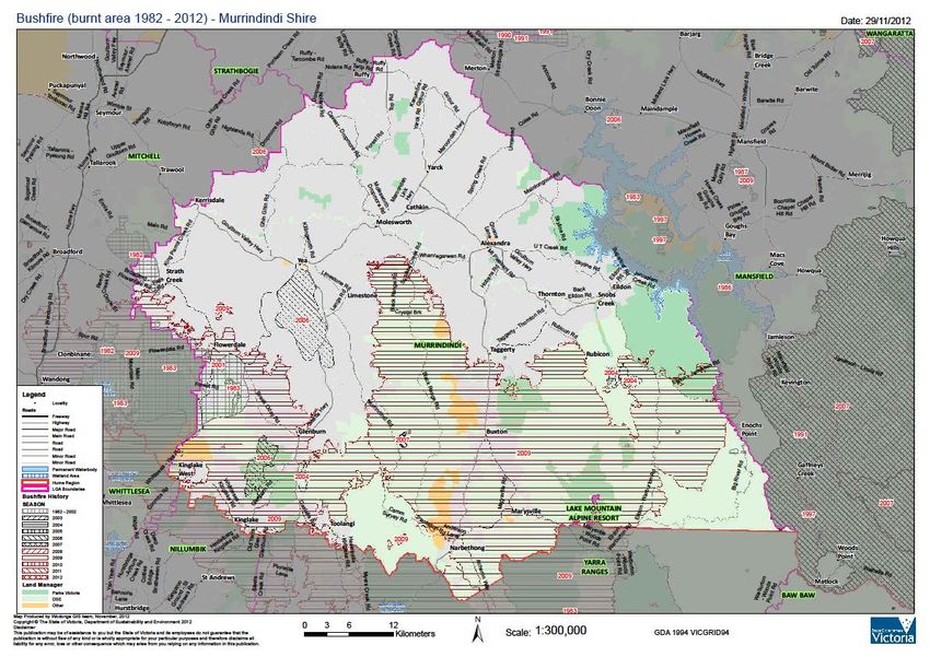
Table of Contents

1.      INTRODUCTION ...................................................................................................... 5

        1.1.     Period and Purpose ................................................................................................ 5

        1.2.     Preparation Process ............................................................................................... 5

2.      ENGAGEMENT AND COMMUNICATIONS ............................................................. 6

        2.1.     Community Engagement ........................................................................................ 6

3.      ENVIRONMENTAL SCAN ........................................................................................ 7

        3.1.     Municipal Profile ..................................................................................................... 7
            3.1.1. Location and Tenure ............................................................................................ 7
            1.1.1. Population and Demographics ............................................................................. 8
            1.1.2. Land Use, Economy and Employment ................................................................. 9
            1.1.3. Traditional Owners ............................................................................................. 10
            1.1.4. Climate............................................................................................................... 10

        1.2.     Bushfire Risk ........................................................................................................ 11
            1.2.1. Bushfire History .................................................................................................. 11
            1.2.2. Strategic Implications of Bushfire ....................................................................... 13

        1.3.     Structural Fire and Hazardous Material Incident Risk........................................ 15
            1.3.1. History of Structural Fire and Hazardous Material Incidents ............................... 15
            1.3.2. Strategic implications of Structural Fire and Hazardous Material Incidents ......... 17

2.      MUNICIPAL FIRE MANAGEMENT OBJECTIVE ................................................... 17

        2.1.     Municipal Objective .............................................................................................. 17

        2.2.     Strategic Direction ................................................................................................ 17

        2.3.     Alignment of Regional and Municipal Objective ................................................ 18

3.      FIRE MANAGEMENT RISK STRATEGIES ........................................................... 19

        3.1.     Risk Assessment Process ................................................................................... 19
            3.1.1. Bushfire Risk Assessment .................................................................................. 22
            3.1.2. Structural Fire Risk Assessment ........................................................................ 28

        3.2.     Risk Management Strategy .................................................................................. 32
            3.2.1. Risk Management Strategy – Bushfire ............................................................... 32
            3.2.2. Risk Management Strategy – Structural Fire ...................................................... 43
Murrindindi Shire Council MFMP                                                                                     Page 2 of 83
Version 7.0
3.3.     Action Plan ............................................................................................................ 46

        3.4.     Fire Management Responsibility ......................................................................... 47
             3.4.1. Response Agencies ........................................................................................... 47
             3.4.2. Essential Safety Measures ................................................................................. 47
             3.4.3. Regulatory and Service Providers ...................................................................... 47
             3.4.4. Community ......................................................................................................... 49

        3.5.     Balancing Fire Risk Against Other Values .......................................................... 49

        3.6.     Cross boundary Management and Links to Other Programs/Processes ......... 50

4.      ROADS, ROADSIDES AND COUNCIL FIRE PREVENTION WORKS .................. 50

        4.1.     General .................................................................................................................. 50

        4.2.     Fuel Reduced Corridors ....................................................................................... 50

        4.3.     Vic Roads - Priority Roads ................................................................................... 51

        4.4.     Fire Access Roads ................................................................................................ 51

        4.5.     Township Maintenance ........................................................................................ 51

        4.6.     Fire Hazard Removal/Fuel Reduction and Hazard Isolation .............................. 52

        4.7.     Allotments and Restrictions on Area Type ......................................................... 53
             4.7.1. Urban Residential Allotments ............................................................................. 53
             4.7.2. Larger Allotments Exceeding I Ha ...................................................................... 53
             4.7.3. Grassland .......................................................................................................... 53
             4.7.4. Undeveloped Municipal Reserves and Municipal Public Land ............................ 53
             4.7.5. Rural Dwellings .................................................................................................. 54

5.      IMPROVEMENT AND PLAN REPORTING AND REVIEW PROCESS ................. 54

APPENDICES .................................................................................................................. 55

        Appendix 1: Consequence and Likelihood Tables........................................................ 55
             Appendix 1A: State Bushfire Consequence Tables ...................................................... 56
             Appendix 1B: CERA Consequence Tables .................................................................. 57
             Appendix 1C: Likelihood Table and Risk Assessment Matrix ....................................... 60

        Appendix 2: Stakeholder Analysis & Community Engagement Plan .......................... 61
             Appendix 2A: Fire Management Roles ......................................................................... 61
             Appendix 2B: Stakeholder Type and Engagement Level .............................................. 62

        Appendix 3: Environmental Scan Maps & Data ............................................................. 63

        Appendix 4: Hazard Trees – Identification and Notification Procedures..................... 68
Murrindindi Shire Council MFMP                                                                                      Page 3 of 83
Version 7.0
Appendix 5: Neighbourhood Safer Place-Places of Last Resort ................................. 72

         APPENDIX 6: FUEL REDUCED CORRIDORS, FIRE ACCESS TRACKS AND PRIORITY
         ACCESS ROADS ............................................................................................................. 73
             Fuel Reduced Corridors ............................................................................................... 73
             Vic Roads - Priority Roads ........................................................................................... 73
             Fire Access Roads ....................................................................................................... 74

         Appendix 7: Glossary and Acronyms ............................................................................ 76

         Appendix 8: References .................................................................................................. 81
             Websites ...................................................................................................................... 81
             General References ..................................................................................................... 81
             Key Legislation, Regulation and Policy......................................................................... 81
                                                              Figures
Figure 1: Murrindindi Shire Municipal Map .................................................................................... 7
Figure 2: Annual mean temperature anomaly Australia (1910-2019)........................................... 11
Figure 3: Structural Fires – Murrindindi Shire – 2015-2020 ......................................................... 15
Figure 4: Murrindindi Shire – Structural Fires by Type – 2015-2020 ............................................ 17
                                                               Tables
Table 1: Fire History in Murrindindi Shire .................................................................................... 12
Table 2: Alignment of MFMP & RSFMP objectives ..................................................................... 19
Table 3: Risk Categories Table ................................................................................................... 20
Table 4: Risk Assessment – Bushfire .......................................................................................... 22
Table 5: Risk Assessment – Structural Fire and Hazardous Material Incidents ........................... 28
Table 6: Risk Management Strategy - Bushfire ........................................................................... 33
Table 7: Risk Management Strategy – Structural Fire and Hazardous Material Incidents............ 43
Table 8: Action Plan Breakdown ................................................................................................. 46
Table 9: Murrindindi Shire and Lake Mountain MFMP Reporting and Evaluation Program.......... 54

Murrindindi Shire Council MFMP                                                                                       Page 4 of 83
Version 7.0
1. Introduction
The purpose of the Municipal Fire Management Murrindindi Shire MFMPC membership
Planning Committees (MFMPCs) is to provide a consists of:
municipal level forum for building and sustaining
organisational partnerships with regards to fire Murrindindi Shire Council
management; and to ensure that plans of Lake Mountain (Southern Alpine Resort
individual agencies are linked effectively so as Management Board)
to complement each other. This is facilitated by Country Fire Authority (CFA)
MFMPCs having a membership consisting of Department of Environment, Land, Water
representatives from key stakeholder and Planning (DELWP)
organisations with respect to fire management
within the municipality.
MFMPCs also act as a sub-committee of their respective MEMPC. Part 6A: Guidelines for
Municipal Fire Management Planning, of the Emergency Management Manual of Victoria, outlines
the suggested terms of reference for these committees, identifies their minimum core membership
and requires the development of a MFMP. These guidelines were used when forming the
Murrindindi Shire Council MFMPC and in the creation of its terms of reference.
1.1. Period and Purpose
Organisation and agencies involved in fire management already have a range of activities, plans,
policies and procedures that are directly involved with, or that impact on fire management. This
MFMP builds on this existing work so as to chart and coordinate the implementation of measures
in use across the municipality designed to minimise the occurrence and mitigate the effects of
bushfires, structural fires and hazmat incidents. It also seeks to identify the need for adopting or
developing new activities, processes and policies, and communicating this need to the relevant
responsible authority.
In doing so it takes into consideration all aspects of fire management:
Prevention – Regulatory and physical measures to ensure that emergencies are
prevented, or their effects mitigated
Preparedness – Arrangements to ensure that in the event of an emergency occurring
all those resources and services that area needed to cope with the effects can be
efficiently mobilised and deployed
Response – Actions taken in anticipation of, during and immediately after an
emergency, to ensure its effects are minimised and that people affected are given
immediate relief and support
Recovery – The coordinated process of supporting emergency affected communities
in the reconstruction of the physical infrastructure and restoration of emotional, social,
economic and physical wellbeing.
MFMPs have a three year planning cycle and this plan has a three-year duration commencing
from the date of council endorsement. However, it will be subject to annual review and
modification as appropriate.
1.2. Preparation Process
This MFMP has been developed in accordance with Part 6A of the Emergency Management
Manual of Victoria and using the IFMP planning process as described in the IFMP Guide. This
process follows a seven stage planning cycle as illustrated in figure 3 below.
Stage 1: Environmental Scanning – establish a municipal base line from which fire
management planning and decision making can be made and measured, including
development of fire management objectives.
Stage 2: Risk Assessment – identification, analysis and evaluation of the fire risks that
potentially impact on the municipality.
Murrindindi Shire Council MFMP Page 5 of 83
Version 7.0 Stage 3: Analysis – analysis of treatment options for achieving the fire management
objectives.
Stage 4: Decide – select the most appropriate risk treatment options to achieve the fire
management objectives.
Stage 5: Publish –once the community and stakeholders have validated the draft MFMP,
the relevant authorities endorse, publish and distribute it.
Stage 6: Deliver - relevant organisations implement the agreed risk treatments in the
MFMP.
Stage 7: Monitor and Improve – track delivery and effectiveness of risk treatments so as
to continually improve the MFMP’s contribution to realising the fire management
objectives.
The planning process used in the production of this plan is risk based and aligns with the
International Standards Organisation (ISO) 31000:2009 (Risk Management – Principles and
Guidelines). Figure 4 (below) describes the alignment of ISO 31000:2009 with the IFMP planning
cycle.
All concerns identified were considered and defined as risk statements with the cause and impact
clearly described. Each of these risk statements were then assessed using the State Bushfire
Consequence Table for bushfire or the Community Emergency Risk Assessment (CERA) tables
for structural fire and hazardous material Incidents. The State ‘Likelihood Table’ and ‘Risk
Assessment Matrix’ (See Appendix 1c) used were endorsed by the State Fire Management
Planning Committee.
2. Engagement and Communications
Stakeholder engagement and participation is an essential element of fire management planning.
Stakeholders are required to participate for a range of reasons, including (but not limited to):
Legislative responsibilities in relation to fire management
Leadership
Provision of hazard expertise and technical advice
Subject to hazard impact (directly and/or indirectly)
Land tenure and management arrangements
Expressed expectation
Influenced and/or support mitigation
Stakeholder engagement is required during all stages in the planning cycle; the aim being for
stakeholders to participate together in the collaborative development, delivery and monitoring of
the MFMP.
Effective engagement with stakeholders in the development and implementation of the MFMP is
an essential tool for drawing on existing knowledge and experience and to build support for and
involvement in this plan.
2.1. Community Engagement
During the development phase of the MFMP the Murrindindi Shire and Lake Mountain MFMPC’s
communication and engagement efforts were focused primarily upon the key stakeholders.
However, a number of community groups were identified as tertiary stakeholders and engaging
with them and the broader community is seen as a critical component to the long term success of
MFMP.
This community engagement process is very much seen as an ongoing responsibility of the
Murrindindi Shire Council MFMPC and it is expected to gain prominence going forward once the
plan is endorsed and especially during review periods.
It is also anticipated that in addition to the activities attributed to the MFMPC, individual key
stakeholders will be utilising their existing processes and undertaking their own community
engagement activities in support of IFMP and the MFMP.
Murrindindi Shire Council MFMP Page 6 of 83
Version 7.03. Environmental Scan
Environmental scanning involves identifying key themes, issues, trends and gaps that may affect
or influence fire management. It establishes the base level of knowledge and understanding
required for supporting risk identification, risk assessment and risk treatment within a fire
management context.
It involves gathering and interpreting data and information relevant to fire management, so as to
make predictions, assumptions and conclusions concerning fire risk for the municipality over the
period of the plan. It also provides the basis for identifying fire management objectives and
decision making with regard to selecting strategies to achieve these objectives.
In undertaking this environmental scanning exercise, the MFMPC gathered information relevant to
fire management from a wide range of sources. Data sources used included the CFA’s Victorian
Fire Risk Register (VFRR), DELWP fuel loading and natural values data, Consequence of Loss
data and ABS Index of Relative Socio-Economic Disadvantage (IRSD). This information was
interpreted using the committee’s extensive knowledge and experience with fire management to
make predictions, educated assumptions and draw conclusions concerning fire risk for the
municipality over the period of the plan.
3.1. Municipal Profile
3.1.1. Location and Tenure
The Murrindindi Shire, located one and a half hours to the north-east of the City of Melbourne,
has an area of 3,889 square kilometres. It is a popular tourist area with a number of National
Parks, State Parks, fertile farming land, the Goulburn River and Lake Eildon.
Figure 1: Murrindindi Shire Municipal Map
Murrindindi was one of the municipalities most heavily-affected by the 2009 ‘Black Saturday’
bushfires. Approximately 40% of the Shire was burnt, which by area represented 154,355
hectares and destroyed 1397 properties.
Murrindindi Shire Council MFMP Page 7 of 83
Version 7.046% of the total land area of the Municipality is forested public land (1,788 square kilometres)
consisting of State Forest, Parks and Reserves and other public land. A large proportion of this
land is mountainous and heavily forested. The Department of Environment, Land, Water and
Planning (DELWP) and Parks Victoria manage the majority of this public land. Other major land
holders include the Lake Mountain Alpine Resort Management Board, Murrindindi Shire Council
and Hancocks Victorian Plantations.
Murrindindi Shire borders the Lake Mountain Alpine Resort which is a member of the Murrindindi
Shire and Lake Mountain MFMPC and MEMPC. Lake Mountain Alpine Resort and Murrindindi
Shire Council have an MOU for shared emergency planning with Murrindindi Shire Council acting
as the ‘principal’ agency on behalf of both groups in emergency management planning (see
MEMPC Appendix A2). Lake Mountain Alpine Resort is located 21 kilometres east of Marysville.
The resort suffered extensive damage in the 2009 fires. It has historically been a winter resort
with over 30 kilometres of cross-country skiing trails. More recently the resort has been
diversifying and focusing on summer activities such as bushwalking and mountain bike riding with
visitor facilities open through the summer period.
1.1.1. Population and Demographics
According to the 2016 Census, Murrindindi Shire has 13,732 Residents. Like many areas in the
Hume region, Murrindindi Shire has an ageing population. In 2011, 18.5% of the population was
over 65 which rose to 23.7% in 2016. This is significantly higher than the national average of
15.8% in this age bracket.
Eildon and Marysville have the highest median age in the Shire, at 51 years old. The townships of
Kinglake and Kinglake West, including Pheasant Creek have the lowest median age, both at 37
years old. Despite being a peri-urban area in close proximity to Melbourne, Marysville has an
older population than other comparable areas.
In 2008-09, Murrindindi Shire experienced a decline in population due to the bushfires of February
2009 in which nearly 1,400 homes were destroyed. In that period, the population fell by 1,000
people or 7.1%. Population levels have not recovered significantly since that time and the
population is currently still lower than in 2008-2009.
The Socio-Economic Indexes for Areas (SEIFA) Index of Relative Socio-economic Disadvantage
(IRSD) ranks areas according to their relative socio-economic disadvantage. The average score
for areas across Australia is 1,000 and areas with a score below 1,000 are more disadvantaged
than the national average. Those areas with a score above 1,000 are less disadvantaged.
Murrindindi Shire has a score of 997 and suggests it has an average level of disadvantage1. 14%
of residents in Murrindindi Shire live in areas considered extremely socially disadvantaged
compared with the national average of 20%. Towns with the highest level of disadvantage in the
Shire are Yea and Eildon.
Murrindindi Shire has a similar proportion of overseas-born residents and those that speak a
language other than English at home, when compared to other parts of rural Victoria. Around
11.5% of the population was born overseas, and around 90% of respondents only speak English
at home. In general, the level of cultural diversity in the Shire reflects other areas of rural Victoria.
In terms of people requiring assistance across the Shire, which includes persons with a disability
or the elderly that require services, 5.4% of the population of Murrindindi Shire are recorded in
this category in the 2016 Census. This is consistent with other rural areas across Victoria and the
percentage of people requiring assistance in the greater Hume Region (5.7%).
Despite efforts to attract employment and investment in regional areas of Victoria over the last 10
years, it is estimated that Murrindindi Shire’s growth forecast will remain low. Murrindindi Shire
has high levels of youth unemployment (at around 12%), which is consistent with the level across
rural Victoria.
1 Australian Bureau of Statistic, Murrindindi Statistics http://statistics.murrindindi.vic.gov.au/
Murrindindi Shire Council MFMP Page 8 of 83
Version 7.0Murrindindi Shire shows elevated unemployment levels amongst the 20-34 year old age group
when compared to other areas in rural Victoria. The rate of unemployment amongst Murrindindi
residents generally declines with age and has been persistently lower than the rural Victoria
average. The unemployment rate in December 2013 was 4%, substantially lower than the rural
Victorian average of 5.4%.
The shire is not in a regional transport corridor and has large numbers of ‘lifestyle’ blocks and
holiday homes. Approximately 30% of the Shire’s rate payers are non-residents.
Internet usage is increasing in Murrindindi Shire but is still lower than the national average - 78%
of Murrindindi Shire households have internet access compared to the national average of 86%.
There is no permanent population at Lake Mountain Alpine Resort.
1.1.2. Land Use, Economy and Employment
The economy of the region revolves around tourism, forestry, mixed (traditional & intensive) styles
of farming, grazing and light industry. Land use is predominantly agricultural and quite diverse,
with grazing on the flatter land in the north and west. In the central areas mixed farming and
hobby farming occurs including mixed fruit, grapes, wool, olives, nurseries, turf and seed
production, exotic animals (alpaca, deer and rabbits) and cattle production. There are some areas
of irrigation adjacent to the Goulburn River.
Agriculture is an important industry in the municipality annually grossing $82.7 million.
Agricultural land utilizes 144,000 hectares in Murrindindi Shire, which is predominantly used for
the raising of animals. The Shire has over 115,000 lambs and sheep, 400 dairy cattle, and
100,000 beef cattle. Agriculture, forestry and fishing employs 12% of the Murrindindi workforce
with the other predominant industries including manufacturing 10%, health and community
services 10%, construction 10%, retail trade 9%, education 9%, and accommodation, restaurants
and cafes 9%. The size of farms and rural holdings is gradually declining in Murrindindi.
Fish production is a major industry in Murrindindi Shire with a number of fish farms and trout
hatcheries. Snobs Creek Hatchery for example, breeds and grows a number of native species
including Murray Cod and Golden Perch and has the only Australian population of Chinook
Salmon. They also breed trout and along with other trout hatcheries in Murrindindi account for
83% of the trout production in Australia. Over 1 million fish and fingerlings are released per
annum from Snobs Creek Hatchery alone into Victorian rivers and waterways.
Outdoor education is an expanding sector within the shire that provides significant employment
opportunities in the outdoor education/recreation area. The range of business activities includes
school camps, mobile outdoor program providers, tertiary education institutions and corporate
training organisations.
Murrindindi Shire is home to a number of major industries and employers such as Kinross Farm
who are of national significance. Every week Kinross Farm provides about one million "live" eggs
to Melbourne company CSL, who is the only manufacturer of flu vaccines in the southern
hemisphere. Located in the Kinglake region, Kinross Farm is a major employer in the Shire. Not
only producing eggs for vaccines, Kinross Farm has a large commercial retail market in the
production of eggs for the food industry.
HVP and a number of smaller businesses run commercial native hardwood extraction in State
Forests and a number of softwood plantations occur throughout the area, particularly in the south
and east. The closure of Demby’s Toolangi Mill in 2007 followed by Gunns Timber Mill in
Alexandra in 2012 caused the loss of over 50 jobs directly related to mill operations and
numerous others as a result of downstream impacts. In 2018 the closing of Dindi Mill also resulted
in a further loss of 17 jobs and brings to a close the timber milling industry within Murrindindi
Shire. These mill closures have had serious local economic impact and are symptomatic of
growing viability issues within the timber sector.
The municipality is well serviced by roads. However, in the mountainous sections some of the
roads are steep, narrow, have restricted access or are of a lower standard. The Goulburn Valley
Highway, Melba Highway and the Maroondah Highway traverse the Municipality
Murrindindi Shire Council MFMP Page 9 of 83
Version 7.0Lake Mountain’s income is based solely on tourism. Net income was around $1.5 million in 2005
but rose to over $6.5 million in 2009. After the destruction of the resort facilities in the 2009 fires,
a reduction in overall net income has generally been experienced by the resort in recent years.
The winter of 2014 however saw visitor numbers increase to 131,692 which is the highest level of
visitation since 2004 and is well above the 10 year average of 93,810. Revenue and winter
visitors at the resort have increased by an impressive 81% from 2013 to the 2014 winter season.
Total income for the 2014 season was $5.6 million. Similarly, Green Season (or non-snow
season) visitation has also continued to grow at the resort. An estimated 60,631 people visited
Lake Mountain during the non-winter months in 2014.
1.1.3. Traditional Owners
The majority of Murrindindi Shire lies in the traditional territory of the Daung wurrung (also spelt
Taungarung) language group, which spread across much of the central region of Victoria. It is
suggested that areas in the south of the Shire, including areas of the Kinglake National Park, are
located in the Traditional lands of the Wurundjeri or Woi wurrung people.
The ethnographic sources suggest that the Daung wurrung group was composed of nine clans,
occupying the Broken, Delatite, Goulburn, Coliban and Campaspe watersheds (Barwick 19842;
Clark 19903).
According to Clark (1990) the majority of lands in the Murrindindi Shire area appear to have been
occupied by the Yowung-illam balug clan of the Daung wurrung. This clan was known to have
occupied land near the Howqua River quarry (Youang-illum stone quarry), Mount Battery,
Alexandra, the Upper Goulburn River at Mansfield, sources of the Goulburn River and Hunter and
Watson’s ‘Wappan’ Run (Clark 1990; Barwick 1984).
There is one Registered Aboriginal Party (RAP) in the area of Murrindindi Shire; the Taungurung
Clans Aboriginal Corporation. RAPs have responsibilities relating to the management of
Aboriginal Cultural Heritage under the Aboriginal Heritage Act 2006. These responsibilities
include evaluating Cultural Heritage Management Plans, providing advice to applications for
Cultural Heritage Permits, making decisions on Cultural Heritage Agreements and offer advice or
applications for Protection Declarations.
For further information about RAPs and their contact details see the Department of Premier and
Cabinet website:
http://www.dpc.vic.gov.au/index.php/aboriginal-affairs/registered-aboriginal-parties
1.1.4. Climate
There is a large variance in the terrain throughout the Murrindindi Shire resulting in several
distinct microclimates. The municipality generally enjoys a temperate climate apart from the
alpine areas of Lake Mountain, with an average summer maximum temperature of approximately
29° C.
Average summer temperatures differ widely across the municipality; Alexandra has a summer
maximum average of 28.6 C° and Toolangi, in the foothills to the south west, 22.2 °C. They both
vary significantly from Lake Mountain which sees average summer temperatures between 6.6°C
to 15.5 °C. Toolangi is generally cooler than Alexandra at any time of year although its winter
minimums are milder. Winter conditions in the Alpine areas average -2.8 °C to 1.6 °C.
Prolonged drought occurred throughout the Shire in the late 1990s to 2009, followed more
recently by flooding events in 2010, 2011 and 2012 causing flooding in some low lying areas.
During 2000-2010 some parts of the Shire recorded up to a 30% reduction in average rainfall.
Most of the rain falls occur in the winter and spring in Murrindindi Shire, with annual average
rainfalls ranging from 710 mm at the Alexandra Post Office to 1363.1 mm at Toolangi. There is a
2
Barwick, D. 1984, 'Mapping the Past: An Atlas of Victorian Clans 1835-1904', Part 1, Aboriginal History 1984, 8(2):100-31
3
Clark, I. 1990. Aboriginal Languages and Clans: An Historical Atlas of Western and Central Victoria, Monash Publications in
Geography No. 7.
Murrindindi Shire Council MFMP Page 10 of 83
Version 7.0large variation in rainfall in Alexandra with the lowest (346mm) rainfall recorded in 2006 and the
highest in 1973 (1089 mm). Although a wetter area in general, Toolangi also has a large variance
in yearly rainfall from 882.9 mm (1997) to 1826 mm (1960). The hilly and mountainous areas of
the shire are consistently wetter than the lower foothills and plains.
The trend of increasing temperatures and increasingly common weather extremes is continuing
across Australia. Figure 2 below shows that there has been a dramatic increase in the mean
temperature anomaly across Australia since 1910.
Figure 2: Annual mean temperature anomaly Australia (1910-2019)
The future climate in the greater Goulburn-Broken region is expected to become hotter and drier
than it is today4. It is also expected that there will be a larger proportion of hotter days, fewer
frosts and a greater incidence of drought5. Higher intensity, but lower predictability, of rain events
is also likely to occur with less rain available for irrigation. These climatic changes will influence
and possibly increase the likelihood of fire in the municipality.
By 2030 it is predicted that the average temperatures in the region will increase by 0.8°C and by
2070, depending on emissions, temperatures will increase on average by 1.4°C to 2.7°C. The
climate is likely to become increasingly erratic with higher occurrences of heat waves, and storms.
These climatic changes will also make fire behaviour harder to predict.
1.2. Bushfire Risk
1.2.1. Bushfire History
Murrindindi has a long history of bushfire. There have been 4 major bushfires in the municipality
since 2000 which include the Castella (Toolangi State Forest) fires of February 2004, Mount
Torbreck (State Forest) fires of April 2004, Kanumbra (“Brilliant” fire) New Year’s Eve 2005,
4
CSIRO and BOM 2012. State of the Climate 2012, Commonwealth Scientific and Industrial Research Organisation, Bureau of
Meteorology.
5 DSE, 2008. Climate change in Goulburn Broken, Department of Sustainability and Environment, Victoria, Melbourne
Murrindindi Shire Council MFMP Page 11 of 83
Version 7.0Kinglake/Glenburn-Yea/Highlands fires of late January/February 2006 and the 7 February 2009
catastrophic fires across the State. A table of the entire known fire history is shown below in
Table 3.
The bushfires of February 2009 had a profound effect on the Murrindindi Shire. There were 95
people killed and 1539 square kilometres, or 40% of the Shire, were burnt. The bushfire had a
catastrophic impact on the communities of Murrindindi and its businesses, tourism and natural
environment were severely impacted as a result. 1397 houses were destroyed as well as 3533
kilometres of fencing. Flora and fauna were also severely impacted: 5 threatened species of
fauna listed under Victoria’s the Flora and Fauna Guarantee Act 1988 occur in the burned areas,
as well as three species listed under the Commonwealth Environment Protection and Biodiversity
Conservation Act 1999.
Table 1: Fire History in Murrindindi Shire
Date Details
1824 (Dec) Messrs Hume & Hovell reported major fires in this area when exploring
1845 (Feb) Fires in Yea district burned for many days and covered large areas
1851 Major state-wide fires. One woman & five children burnt to death at Happy Valley,
("Black Thursday") Flowerdale. Plenty Ranges badly affected
1877 Fires across Victoria particularly in timbered country
1889 Major fires in Yea district following severe flooding during prior winter / spring
1898 Bad outbreaks Narbethong, Marysville, Healesville, Kilmore, Seymour
1899 Major fires Yea, Broadford, Kilmore, Seymour
1900 Bad fires Yea & Kilmore. Yea severely threatened. This fire burned for some weeks in
Yea district
1901 Large fires Yea, Alexandra, Mansfield, Kilmore, Broadford, Longwood
1902 Outbreaks of large size Molesworth, Broadford, Kilmore
1906 Large Fires at Alexandra & Kilmore
1922 (13 Feb) Fire originated in Highlands - Caveat area and covered significant area. Other
outbreaks this year particularly in forested areas
1926 Disastrous state-wide fires; lives lost at Kinglake. Hotel, church, public hall and
houses lost
1927(Feb) Rabbit poisoners started fire in Highlands area which burned to Cathkin. Stopped on
north side of Goulburn River
late 1920's Outbreak started near Alexandra. Burned through hilly country north of the Goulburn
to almost Eildon. Burned with astonishing speed according to reports
1939 Major fires across Victoria, particularly in forests. 71 lives lost, 69 sawmills and 700
(13 Jan) homes destroyed. Rubicon, Toolangi, Black Spur severely affected
1944 Serious outbreaks at Alexandra, Toolangi (Nov), Molesworth and other areas
1950 Large outbreak started on railway line near Native Dog Creek and burnt to
Whanregarwen Road. One person badly burned
1951 Whanregarwen area 4,000 acres
1957 Serious outbreak Acheron - Thornton area
1959 (12 Jan) Fire started at Yarck fanned by strong northerly. 10,000 acres including stock, fencing
1962 Kinglake threatened by major fire starting near St Andrews
1969 (8 Jan) Extensive areas of Yea and Alexandra districts burned involving loss of one life, 30
houses, large stock and fencing losses. Much of former Shires of Yea and Alexandra
were burned. Points of origin - Acheron Cutting, Ghin Ghin & Junction Hill
1981 (19 Mar) Dairy Creek Road area - Yea 10,434 hectares
1982 (Nov) Fire started near Wandong. Burned to Wallaby Creek area -Mt Robertson and into
King Parrot Valley
1983 Ash Wednesday fires across Victoria. Marysville threatened by Warburton outbreak
(“Ash Wednesday”)
1985 (15 Jan) Acheron - Taggerty- Thornton area
Murrindindi Shire Council MFMP Page 12 of 83
Version 7.0Date Details
1991 Significant fires at Ghin Ghin and Thornton involving thousands of hectares, and
Strathbogie area which spread towards Merton
2004 (Feb) Significant fire at Mt Torbreck (DELWP land) 637 hectares burned
2004 (April) Castella (DELWP land) 100 hectares lost
2005(Dec 31) Kanumbra (“Brilliant” fire) significant grass fire 500 hectares burned
2006 (late Jan)
Significant fires at Kinglake (Parks Victoria/DELWP land); Glenburn/Yea and
Highlands (Loss of life to one CFA volunteer on fire front)
2009 (Feb 7) Catastrophic fires across the State of Victoria and within the southern areas of the
(“Black Saturday”) Murrindindi Shire, which caused devastation to the areas of Marysville, Granton,
Narbethong, Buxton, Taggerty, Toolangi, Castella, Kinglake, Kinglake Central,
Pheasant Creek, Kinglake West, Flowerdale, Strath Creek, Glenburn areas. The
number of dwellings destroyed by this fire was 1,397. Significant loss of life also
occurred resulting in 95 deaths within Murrindindi Shire.
1.2.2. Strategic Implications of Bushfire
Bushfire can occur in any type of vegetation, such as grassland, trees, crops or shrubs. This
section describes the Murrindindi municipality and factors that increase the likelihood of a fire
starting and spreading across this area. The MFMP is the strategy that categorises risk and
identifies appropriate treatment to address improved fire safety measures across the municipality.
Murrindindi Shire has a range of assets and features which make it a vibrant place to work live or
visit. These include large townships, small communities, and rural areas, industries such as
agriculture, agribusinesses and tourism and important infrastructure for essential services such as
transport, power, and communications. In addition to the built environment the municipality boasts
a range of natural assets such as good quality water resources and extensive native forests which
are valued for their environmental, commercial and visual appeal.
The municipality of Murrindindi has experienced a number of fires over the years and was
particularly impacted by the 2009 ‘Black Saturday’ Fires. The combination of topography, climate,
vegetation, coupled with the increasing number of people living in and visiting high fire risk
localities during the fire danger period poses a significant issue for the municipality.
1.2.2.1. Vegetation and Topography
The vegetation and topography of the municipality create a number of challenges for fire
management. The shire is heavily treed with 48% tree cover predominantly in the mountainous
sections spread throughout of the shire including the sub alpine and alpine areas around Lake
Mountain Alpine Resort. These areas have a number of steep escarpments and highly varying
topography, are heavily vegetated, have limited access or egress and have a number of water
courses flowing through them. Murrindindi Shire also has a number of neighbouring
municipalities with a large percentage of tree cover and fires can spread from these municipalities
into Murrindindi Shire or from Murrindindi Shire into these municipalities (e.g. Yarra Ranges). All
of these factors combine to make fire control and response difficult in Murrindindi Shire.
A number of major rivers and streams flow through the municipality including the Goulburn River,
the Rubicon River, Acheron River, Taggerty River, Steavenson River, Little Steavenson River,
Yea River, Murrindindi River and the King Parrot Creek and associated river valleys. The
Goulburn River runs east to west through the Shire with its tributaries draining from both the north
and south. Although providing a reliable water resource and a natural fire break, access across
these major rivers and streams is generally restricted to bridges and crossing points which may
delay emergency response times.
Murrindindi Shire Council MFMP Page 13 of 83
Version 7.0Bushfire threat is not confined to forested environments and the threat of grass fires is a
significant one throughout the shire. While grassfires may have lower intensities and flame
heights than forest fires, the combination of open ground and fine fuels can produce very fast
moving destructive fires.
1.2.2.2. Weather and Climate impact on Bushfire Risk
Weather conditions and climate also impact on fire management in Murrindindi Shire. For
instance, the bushfire seasons from 2000-2009 were increased in length due to the wide-spread
impact of severe drought. In 2016-17 summer season however, the summer was milder and had
more rainfall. Traditionally, the municipality has experienced spring rains and mild conditions that
promote growth followed by hot summers which lead to high fuel loads.
Rainfall patterns largely dictate corresponding fuel growth, particularly in grasslands, and directly
influence fire prevention programs across Murrindindi Shire. Grass fuel cures on a gradient
across the Shire and seasonal differences can mean that any given grassland does not cure at
the same time every year. Generally, in the north and eastern sections of the Shire, where it is
warmer and drier, grasslands cure much earlier than those areas to the south and west. Fire
prevention programs for all agencies are influenced by these variations. For example, Murrindindi
Shire Council’s fire prevention works normally start around the township of Eildon in the east of
the Shire in September or October and progress towards Kinglake in the southwest. Council’s fire
prevention works mirror the grass curing rates as the curing process spreads westwards and
southwards as the warmer month’s progress. Bureau of Meteorology data and CFA’s curing data
are also discussed in depth by the Murrindindi Shire Council MFMPC before every fire season.
These seasonal discussions directly influence the on-ground fire prevention works of all member
agencies.
The usual pattern during summer months is north westerly winds accompanied by high day time
temperatures and low relative humidity. These climatic conditions can build up over several days
to a storm event with a sudden south westerly wind change, creating a situation whereby fire
ignition from lightning becomes a more likely occurrence. The propensity of a southerly wind
change, often results in the fire changing direction quickly, thus transforming the fire’s extensive
flank into the new fire front.
1.2.2.3. The Effect of Bushfires on People
Murrindindi has experienced a number of fires in recent years. The combination of varied
topography, climate and vegetation coupled with the increasing number of people living in and
visiting high fire risk localities during the fire danger period poses a significant issue for the
municipality. Murrindindi Shire’s population of approximately 14,000 people expands substantially
during the summer months with holiday makers drawn to the area by the combination of
recreational and camping areas, centred on Lake Eildon and the various National and State
Parks. A large number of non-resident rate payers have holiday properties spread throughout the
shire that are highly utilised over the summer period. A significant number of visitors also arrive
at, or pass through the region in winter on their way to the Alpine Resorts at Mt Buller, Mt Stirling
and Lake Mountain.
Murrindindi Shire has people with different perspectives and different needs in regard to fire and
fire safety. Understanding these needs is central to delivering effective community safety
initiatives. This is particularly important for people new to the area and also in capturing the
knowledge and expertise of those that have had many years of experience living with fire risk.
The impact of a bushfire increases if the fire occurs in areas where people live, work and visit, so
consequently, settlement patterns are important when evaluating bushfire risk. There is sufficient
land availability for population expansion around the urban areas of Alexandra, Kinglake Ranges,
Eildon and Yea, both at the town’s edges and less intensively throughout the rural areas.
Tourism, planned events and festivals have the potential to impact on human movement during
the fire danger period, interacting with fire management at several points, particularly on the
foreshore of Lake Eildon and in the National and State Parks and Forests in the shire. In 2014
Murrindindi Shire Council MFMP Page 14 of 83
Version 7.0798,000 people visited the Goulburn Broken region which is approximately a 25% increase over
20136. Many of these visitors come to the municipality for its landscape and natural values and
spend a large percentage of their time outdoors. The same landscape features that may lead to
increased fire danger can also be underpinning elements of what makes the site attractive for
tourism. Furthermore visitor numbers tend to increase as the fire season advances, escalating the
potential impact as the fire risk rises.
1.3. Structural Fire and Hazardous Material Incident Risk
Structural fire is a fire that may impact the structural components of various types of residential,
commercial or industrial buildings. It is a separate category of fire to bushfire although structures
may be lost during bushfires and it may require the use of entirely different techniques to
extinguish when compared to bushfire. Structural fire in Murrindindi Shire is generally confined to
one or a few buildings and as a result, generally has lower personal and property impacts than a
large bushfire event.
Hazardous materials are defined as:
“anything that when produced, stored moved, used or otherwise dealt with without
adequate safeguards to prevent it from escaping, may cause serious injury or death or
damage to life, property or the environment”7.
Hazardous Material Incidents occur when a hazardous material is exposed to people or the
environment through an accident, production, storage and removal and a lack of adequate
safeguards.
1.3.1. History of Structural Fire and Hazardous Material Incidents
Murrindindi Shire has a long history of structural fire8. This was especially true in early settlement
where there was a reliance on wood fires for cooking and heating and candles for illumination,
combined with predominantly wooden buildings with little or no planning control. The first major
structural fire in Murrindindi Shire was the Grant Street Fire of the 4th of November 18729. This
fire resulted in most of the eastern side of Grant Street (Alexandra main street) being destroyed.
The fire began in Hamea’s Corner Hotel (now the Commercial Hotel) on the corner of Grant and
Downey Streets at three am and quickly spread to other buildings. By sunrise the next day a
large part of the shopping district including two hotels, the Public Library, Union Bank, saddlers
shop and a butchers shop had been burned to the ground. The fire was stopped by the
destruction and removal of a dilapidated cottage between two businesses and a large brick wall.
Other notable historic structural fires include a number of fires at the former timber mills around
Alexandra and Rubicon and in 1946, a major structural fire at a furniture store on Grant St
Alexandra. In 1957 a similarly large structural fire nearly destroyed the Alexandra Hospital.
Marysville has also experienced a number of structural fires historically, many involving
guesthouses.
In the past 5 years, there have been 117 structural fires in Murrindindi Shire. The majority of these
have occurred in Alexandra, Yea and Eildon.
Figure 3: Structural Fires – Murrindindi Shire – 2015-2020
6 Goulburn Valley River Tourism 2012, Travel to Goulburn River Valley, year ended March 2012,
www.goulburnrivervalley.com.au/visitationstatistics
7 NSW Fire and Rescue, 2013, Hazardous Material (Hazmat) definition, http://www.fire.nsw.gov.au/page.php?id=19
8 Rice, P. 2005, Alexandra District Fire Brigades Group history page, http://www.virtual.net.au/~alexgroup/History.htm
9
Sydney Morning Herald Destructive Fire at Alexandra, Victoria, 14th November 1872
Murrindindi Shire Council MFMP Page 15 of 83
Version 7.025
20
15
10
5
0
The spike in structural fires in Eildon is understood more fully when the 7 water craft fires that add
to the total are removed. However, given its lower population, 13 fires is still significant for a small
population. Eildon house fires are common – given houses are located closely together and are
relatively cheaply built holiday homes, there is a risk of house fires spreading to surrounding
houses. As a result, house fires in Eildon always require a quick CFA presence and a minimum of
three tankers for every turn out.
Figure 4 below summaries the fires in figure 3 by type. The predominant fire type are house fires
where structure and contents are both impacted. Unsurprisingly in an area that relies for the most
part on wood heating, chimney or flue fires are also common.
Interestingly in the past 5 years, electrical faults outside the premises have resulted in a number
of fires where transformers and or power lines have provided the fire start.
Murrindindi Shire Council MFMP Page 16 of 83
Version 7.0Figure 4: Murrindindi Shire – Structural Fires by Type – 2015-2020
40
35
30
25
20
15
10
5
0
Lake Mountain Alpine Resort was impacted by a serious fire in the Visitor Centre in June 2009.
Whilst not destroying the building itself, the fire caused approximately $2,000,000 in damages.
Murrindindi Shire has had a small number of hazardous material incidents such as fuel spillage
and similar incidents. No major hazardous material incidents have been recorded in the Shire.
1.3.2. Strategic implications of Structural Fire and Hazardous Material
Incidents
Structural fire is confined predominantly to the more settled, urban and industrial areas of
Murrindindi Shire although agricultural fires, such as haystack fires and machinery fires, may also
have an impact on structures in the farming areas. Generally structural fires are not deliberately lit
but cases of arson have been recorded.
Hazardous material incidents in Murrindindi Shire are generally confined to industrial areas, farms
and roads (transport of goods). CFA are the control agency for both structural fire and hazardous
material incident
2. Municipal Fire Management Objective
The municipal fire management objective provides a framework for considering, selecting and
evaluating fire management activities.
2.1. Municipal Objective
The fire management objective of Murrindindi Shire Council MFMPC is:
The Murrindindi Shire working together to plan for, respond to and recover from fire and
hazardous material incidents – to reduce the risk of fire to the community, environment and
economy in the Murrindindi Shire
2.2. Strategic Direction
In developing strategic directions for the MFMP, the MFMPC was mindful of the planning context
within which they were undertaking this task. As illustrated in figure 2 (above) the MFMP forms a
critical third tier in the State of Victoria’s Fire Management Planning hierarchy and therefore must
not be developed in isolation from State and Regional level fire management plans.
Murrindindi Shire Council MFMP Page 17 of 83
Version 7.0The MFMPC are keen to ensure any actions within the MFMP support and complement any
relevant State objectives and strategies with regard to fire management. Consequently, the
MFMPC have aligned their objectives to the State Fire Management Strategy 2014:
The State Fire Management Strategy 2014 states that
The objective of all bushfire management activities in Victoria is to reduce the impact and
consequences of bushfire on human life, communities, essential and community
infrastructure, the economy and the environment.
The State strategy identifies the following principles to guide bushfire management activities.
Leadership
Protection of human life
Responsibility for building resilience
Community involvement
A seamless approach
Risk driven
Learning and knowledge
2.3. Alignment of Regional and Municipal Objective
The Murrindindi municipal fire management
objectives aligns closely with the Hume Hume Regional Strategic Fire Management
Region Strategic Fire Management Planning Planning Committee Vision
Committee (RSFMPC) objectives and vision
The Hume Region working together to
for fire management. The development and effectively anticipate, respond to and recover
implementation of this plan will therefore from major bushfire – to secure a safer region,
contribute significantly to the realisation of more resilient community, healthier environment
the Hume RSFMPC’s vision. and a prosperous economy.
Recently further work has been completed
under the guise of safer-together at the regional level producing a multi-agency Hume Region
Bushfire Management Strategy due for public release at the end of February 2020. This strategy
builds upon current plans using predictive fire modelling techniques to produce a common picture
of risk across the landscape – regardless of land tenure. It is imagined further updates to this
document will occur as a result of the release of the strategy.
The formation of the Murrindindi Shire and Lake Mountain MFMPC and the development of a
MFMP using the designated IFMP Planning Guide have strongly supported several of the
Regional Strategic Fire Management Plan (RSFMP) key objectives. Evidence of this is described
in the following Table 4 below.
Murrindindi Shire Council MFMP Page 18 of 83
Version 7.0Table 2: Alignment of MFMP & RSFMP objectives
RSFMP element RSFMP objective MFMP contribution
Develop state, regional, municipal and The MFMP provides the third tier in the
local fire management plans and IFMP process and utilises the same risk
Planning together
planning with a clear purpose and a base approach as used with State and
consistent assessment of risk. Regional plans
The MFMPC consists of multiagency
Develop and implement fire
Collaborative representation and has incorporated
management programs and activities in
implementation community engagement strongly into the
a collaborative manner.
development of the MFMP.
Build and share knowledge in the fire
The aspirations of the MFMPC converge
management sector and across the
with the regions in seeking to build both
Building knowledge & community.
its members and the communities’
capacity: Improve the capability of communities,
knowledge and understanding of fire
the fire management sector and the
management.
government to deal with fires.
Improve the capability of communities, To ensure there is a coordinated and
Building capacity the fire management sector and the locally tailored consultation to avoid
government to deal with fires. gaps and duplication.
To ensure fire is used appropriately in
Using fire to support the health of
the municipality to support the health of
Using fire environmental, social and economic
environmental, social and economic
environments.
values
The development of this MFMP clearly
Implementation Support the implementation of the IFMP
demonstrates support for IFMP at a
support framework in the Hume region
municipal level.
3. Fire Management Risk Strategies
3.1. Risk Assessment Process
As a first step in the assessment process, each of the identified risks were refined into succinct
‘risk statements’ and entered into a risk register. Risk statements are a description of the risk and
simply describe the risk in terms of the source through to the impact. Each risk statement outlines:
the hazard (source of risk)
the element at risk
the consequence of the interaction as a result of an event.
Each of these statements was then qualitatively assessed for their impact using the State Fire
Management Planning Committee’s State Bushfire Consequence Table (Appendix 1a) for
bushfire risk and the Community Emergency Risk Assessment (CERA) risk consequence table for
Structural Fire and Hazardous Material Risks (Appendix 1b).
Each consequence was considered in terms of both damage and disruption (loss of service or
function) and in some cases, the consequence of an event was not realised at the local level but
was of a significant impact at regional and/or state level. In addition the committee took into
account existing treatments and their impact on the risk level. Consequence ratings were then
entered into the risk register.
Murrindindi Shire Council MFMP Page 19 of 83
Version 7.0You can also read