JERICO-S3 D4.1. DELIVERABLE TITLE: JERICO-S3 Pilot Supersite monitoring strategies
←
→
Page content transcription
If your browser does not render page correctly, please read the page content below
The JERICO-S3 project is funded by the European Commission’s H2020 Framework Programme under grant
                 agreement No. 871153. Project coordinator: Ifremer, France.

                                            DELIVERABLE TITLE:

                            JERICO-S3 D4.1.
             JERICO-S3 Pilot Supersite monitoring strategies

DELIVERABLE NUMBER: D4.1.
WORK PACKAGE N° and NAME: WP4 Pilot Supersites for innovative
coastal monitoring
Authors: Jukka Seppälä (SYKE), Constantin Frangoulis (HCMR)
Involved Institution: SYKE, HCMR, HZG, IFREMER, SOCIB, AWI, CEFAS,
CNR, CNRS, Deltares, FMI, IMR, IOW, NIVA, PdE, RBINS, RWS, TalTech,
UPC, VLIZ
Submission date: final version: 06 May 2021, submitted 07 May 2021
Nature: R
(R = Report, P = Prototype, D = Demonstrator, O = Other)

Dissemination level : PU
PU = Public, PP = Restricted to other programme participants (including the Commission Services), RE = Restricted to a group
specified by the consortium (including the Commission Services), CO = Confidential, only for members of the consortium (including
the Commission Services)

                                                                     Reference: JERICO-S3-WP4-D4.1-06.05.2021-V2.1
                                                                                                         Page 1/99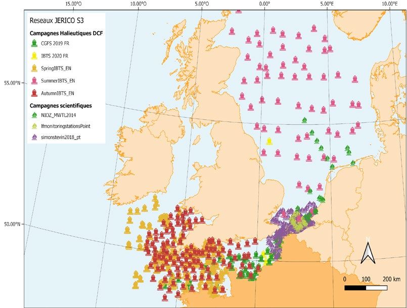
The JERICO-S3 project is funded by the European Commission’s H2020 Framework Programme under grant
                       agreement No. 871153. Project coordinator: Ifremer, France.

  GRANT N°: 871153
  PROJECT ACRONYME : JERICO-S3
  PROJECT NAME : Joint European Research Infrastructure for Coastal Observatories -
  Science, services, sustainability
  COORDINATOR : Laurent DELAUNEY - Ifremer, France - jerico@ifremer.fr

According to the Regulation (EU) 2016/679 of the European Parliament and of the Council of 27 April 2016 on the protection of natural persons with regard to the
processing of personal data and on the free movement of such data, and repealing Directive 95/46/EC (General Data Protection Regulation) and the 78-17 modified
law of 6 January 1978, you have a right of access, rectification, erasure of your personal data and a right of restriction to the data processing. You can exercise your
rights before the Ifremer data protection officer by mail at the following address: IFREMER – Délégué à la protection des données- Centre Bretagne – ZI de la Pointe
du Diable – CS 10070 – 29280 Plouzané - FRANCE or by email: dpo@ifremer.fr // jerico@ifremer.fr
Ifremer shall not hold your personal data for longer than necessary with regard to the purpose of the data processing and shall destroy it thereafter.

                                DOCUMENT TECHNICAL DESCRIPTION
   Document ID                                 JERICO-S3-WP4-D4.1-04.05.2021-V2

                                                   JERICO-S3 DELIVERABLE
           Joint European Research Infrastructure network for Coastal Observatory
                            Science, Services, Sustainability
    DELIVERABLE n°                                   JERICO-S3 D4.1 WP4 Pilot Supersite monitoring strategies
    WP and full title

                                                     The deliverable provides regionalized innovative monitoring and science
                                                     strategy at each Pilot Supersite. Implementation plan for each PSS is
                                                     given, to address the key regional research questions, including
    Description                                      sampling strategy, PSS integration strategy, best practices used,
                                                     identification of data flows, QC routines and products, dissemination
                                                     plan, and links to other regional observatories, PSSs and RIs.

    Lead beneficiary                                 SYKE

    Lead Authors                                     Jukka Seppälä (SYKE), Constantin Frangoulis (HCMR)

                                                     Timo Tamminen (SYKE), George Petihakis (HCMR), Holger Brix
                                                     (HZG), Klas Ove Möller (HZG), Ingrid Puillat (IFREMER), John
                                                     Allen (SOCIB), Joaquín Tintoré (SOCIB), Laurent Coppola
                                                     (CNRS), Francois Bourrin (CNRS), Alain Lefebvre (IFREMER)
                                                     Romaric Verney (IFREMER), Anouk Blauw (DELTARES), Lauri
    Contributors                                     Laakso (FMI), Milla Johansson (FMI), Gregor Rehder (IOW), Taavi
                                                     Liblik (TALTECH), Urmas Lips (TALTECH), Behzad Mostajir
                                                     (CNRS), Annalisa Griffa (CNR), Maristella Berta (CNR), Begoña
                                                     Pérez Gómez (PdE), Baptiste Mourre (SOCIB), Joaquin Del Rio
                                                     (UPC), Yoana Voynova (HZG), Helene Frigstad (NIVA), Felipe
                                                     Artigas (CNRS), Veronique Creach (CEFAS), Naomi Greenwood

                                                                                           Reference: JERICO-S3-WP4-D4.1-06.05.2021-V2.1
                                                                                                                               Page 2/99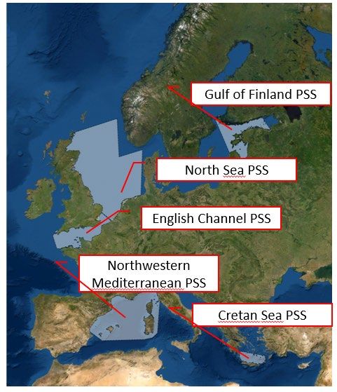
The JERICO-S3 project is funded by the European Commission’s H2020 Framework Programme under grant
            agreement No. 871153. Project coordinator: Ifremer, France.

                                (CEFAS), Klaas Deneudt (VLIZ), Henning Wehde (IMR), Philipp
                                Fischer (AWI), Michael Fettweis (RBINS), Lisette Enserink (RWS),
                                Kostas Tsiaras (HCMR), Melilotus Thyssen (CNRS), Andrew King
                                (NIVA)

 Submitted by                   Jukka Seppälä (SYKE)

REVISION HISTORY

 Revision         Date                 Modification                           Author

V0.1              3.6. 2020            Table of Contents and                 Seppälä, Frangoulis
                                       responsibilities for partners
V0.2              14.10.2020           Draft of sections 2 and 3             Seppälä, Frangoulis, et al.
V0.3              14.10.2020           GoF and CRETAN PSS                    Seppälä, Frangoulis
                                       implementation             plans
                                       provided as examples
V0.4              20.12.2020           All comments for PSS                  Seppälä, Frangoulis, Coppola,
                                       implementation plan received          Brix, Lefebvre and PSS partners
V1.0              8.2.2021             Parts combined and edited             Seppälä, Frangoulis, et al.
V2.0              30.4.2021            Editing typographic errors            Seppälä, Frangoulis
                                       and style. Inclusion of
                                       Conclusion chapter 6.
V2.1              06.05.2021           Referencing revision and              Ingrid Puillat, Laurent Delauney
                                       formatting, final validation

APPROVALS
                  Name                        Organisation          Date                Visa
Coordinator       Delauney Laurent            Ifremer               06 May 2021                     LD
WP Leaders        Jukka Seppälä               SYKE                  05 May 2021                     JS

 Diffusion list

 Consortium                   Third parties                  Associated Partners            other
 beneficiaries

            X                             X

PROPRIETARY RIGHTS STATEMENT
THIS DOCUMENT CONTAINS INFORMATION, WHICH IS PROPRIETARY TO THE JERICO-S3 CONSORTIUM. NEITHER THIS
DOCUMENT NOR THE INFORMATION CONTAINED HEREIN SHALL BE USED, DUPLICATED OR COMMUNICATED EXCEPT WITH
THE PRIOR WRITTEN CONSENT OF THE JERICO-S3 COORDINATOR.

                                                         Reference: JERICO-S3-WP4-D4.1-06.05.2021-V2.1
                                                                                             Page 3/99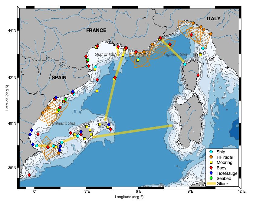
The JERICO-S3 project is funded by the European Commission’s H2020 Framework Programme under grant
agreement No. 871153. Project coordinator: Ifremer, France.
Table of Contents
1. EXECUTIVE SUMMARY .............................................................................................................................................. 6
2. INTRODUCTION ........................................................................................................................................................... 7
2.1. Supersite concept in Environmental RIs ................................................................................................... 8
2.2. Concept of JERICO Supersite........................................................................................................................... 9
2.3. Overall objectives of JERICO Pilot Supersites ........................................................................................10
3. SCIENCE STRATEGY FOR PILOT SUPERSITE IMPLEMENTATION........................................................14
3.1. Key common scientific questions within JERICO-S3 ..........................................................................14
3.2. JERICO-S3 Pilot Supersite regions ..............................................................................................................17
3.3. Common and region-specific scientific research topics for PSSs ..................................................21
3.4 Common and region-specific organizational challenges for PSSs..................................................24
3.4. Links to other RIs and overall user communities ................................................................................27
3.5. Common societal and economic impacts ................................................................................................27
3.6. Key regional actors and user communities ............................................................................................28
3.7. Critical gaps in multidisciplinary data provision for user needs...................................................31
4. IMPLEMENTATION STRATEGIES FOR PILOT SUPERSITES ....................................................................33
4.1. Implementation strategies: Gulf of Finland Pilot Supersite.............................................................33
GoF PSS #1 Harmonized observations.........................................................................................................35
GoF PSS #2 The performance of operational forecast models...........................................................37
GoF PSS #3 Optical data for Ocean Color product validation .............................................................39
GoF PSS #4 Detection of cyanobacterial blooms .....................................................................................41
GoF PSS #5 Mapping the deep-water oxygen conditions.....................................................................43
GoF PSS #6 Biological interplay with the carbonate system ..............................................................45
GoF PSS #7 Forecast models for cyanobacterial blooms .....................................................................47
GoF PSS #8 Extreme events affecting phytoplankton - AQUACOSM collaboration I ................48
GoF PSS #9 Promotion of the use of PSS data and products ...............................................................50
GoF PSS #10 Connecting the other RIs in the region .............................................................................51
4.2. Implementation strategies: North-West Mediterranean Pilot Supersite ...................................52
NW-MED PSS #1: Reconstruction of the 3D coastal dynamics ..........................................................54
NW-MED PSS #2: Impacts of river discharge to coastal ecosystems, .............................................56
NW-MED PSS #3: Extreme events affecting phytoplankton - AQUACOSM collaboration II ..58
NW-MED PSS #4: Biogeochemical data and ocean colour products ...............................................60
NW-MED PSS #5: RI interactions ...................................................................................................................62
NW-MED PSS #6: Transnational integration ............................................................................................64
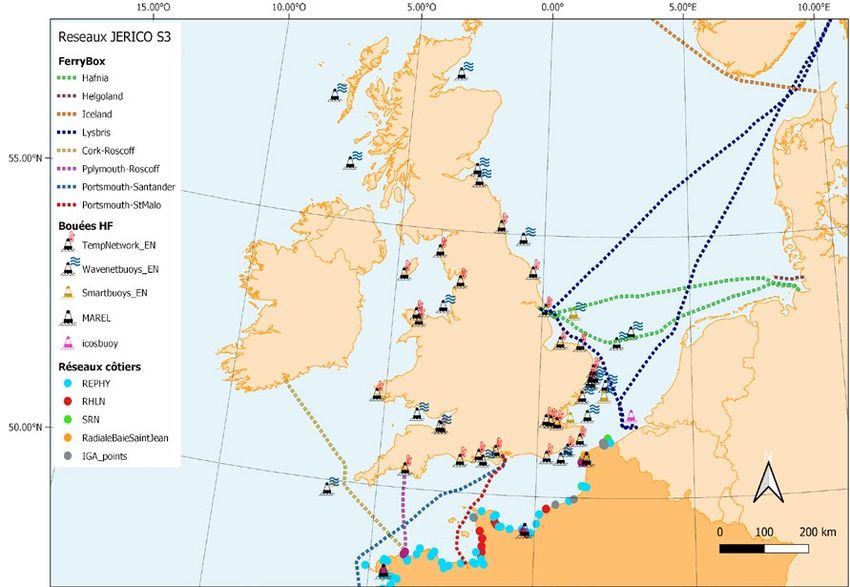
4.3. Implementation strategies: North Sea and English Channel Pilot Supersite............................65
NSEA PSS #1 Harmonised observations of regional C fluxes. ............................................................68
Reference: JERICO-S3-WP4-D4.1-06.05.2021-V2.1
Page 4/99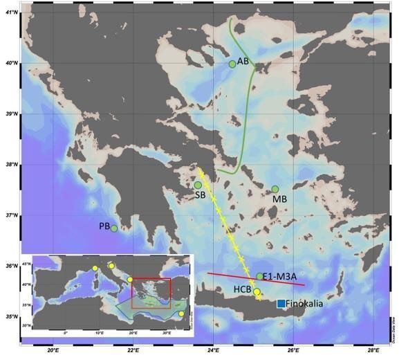
The JERICO-S3 project is funded by the European Commission’s H2020 Framework Programme under grant
             agreement No. 871153. Project coordinator: Ifremer, France.

        NSEA and CHANNEL PSS #2 Riverine input to the North Sea. ...........................................................70
        CHANNEL PSS #3 Harmonised observations of plankton biomass, diversity and
        productivity dynamics. .......................................................................................................................................72
        CHANNEL PSS #4 Products for Eutrophication Status Assessment. ...............................................74
        NSEA and CHANNEL PSS #5 Intercomparison of phytoplankton distribution using data
        integration. ..............................................................................................................................................................75
        NSEA and CHANNEL PSS #6 Identification of Observational Gaps. .................................................77
        NSEA and CHANNEL PSS #7 Cross-regional communication between PSSs (North Sea and
        Channel)....................................................................................................................................................................78
        NSEA and CHANNEL PSS #8 Support to EU directives and ecosystem management. .............79
        NSEA and CHANNEL PSS #9 Interaction with other RIs on ecosystem studies,
        eutrophication, coastal management and carbon fluxes. .....................................................................81
    4.4. Implementation strategies: Cretan Sea Pilot Supersite .....................................................................82
        CRETAN PSS #1 Solubility and biological pumps ....................................................................................84
        CRETAN PSS #2 Improved approximations of Primary Production ...............................................86
        CRETAN PSS #3 Extreme events affecting phytoplankton - AQUACOSM collaboration III ...87
        CRETAN PSS #4 Upscale of Regional Data to a wider area..................................................................89
        CRETAN PSS #5 New sampling strategies, new technologies, best practices .............................90
        CRETAN PSS #6 Partnership building..........................................................................................................92
    4.5. PSS links and interfaces ..................................................................................................................................94
5. OUTREACH, DISSEMINATION AND COMMUNICATION ACTIVITIES ...................................................96
6. OUTLOOK OF JERICO-RI SUPERSITES ..............................................................................................................97
7. REFERENCES ...............................................................................................................................................................98

                                                                                          Reference: JERICO-S3-WP4-D4.1-06.05.2021-V2.1
                                                                                                                              Page 5/99
The JERICO-S3 project is funded by the European Commission’s H2020 Framework Programme under grant
       agreement No. 871153. Project coordinator: Ifremer, France.

1. EXECUTIVE SUMMARY
WP4 provides a practical demonstration of how JERICO-RI Pilot Supersites (PSS) are to be
implemented in order to become a network of Supersites, by establishing or improving, their
communication and steering at multiple levels, and their links to other observatories, RIs and
regional initiatives.
The key objective of this deliverable is to provide implementation strategies for JERICO-RI
PSS. PSSs are used to demonstrate how transnationally and transinstitutionally integrated
multidisciplinary and multiplatform observations may add value to our ability to answer the
multiple key scientific and social challenges the coastal ocean is facing. During the JERICO-
S3 project, PSSs are tested for a short period (approx. 2 years), across the European coastal
seas, covering a wide range of environmental conditions and research topics.
This deliverable defines the concept of coastal Supersites, highlighting the differences to the
terrestrial ones. A coastal Supersite must provide observations at the appropriate nested
spatiotemporal scales of coastal processes. To yield the required vertical, horizontal and
temporal resolution, and for a set of multidisciplinary lists of variables (EOVs and EBVs),
coastal observations need to be performed in an integrated way using multiple. In most regions
this requires active collaboration between different actors performing observations
(institutions, monitoring programs, industry, etc.) and feedback from users. The deliverable
provides a first list of key requirements for JERICO-RI PSSs and eventually for coastal
Supersites.
Science strategy for PSSs provides an outlook for a range of scientific challenges in the
coastal ecosystems. As the resources are limited, the actual work with PSSs will focus on
selected specific regional challenges, including also pan-European ones, testing and
effectively reviewing collaboration mechanisms within the PSSs. Besides advancing the
coastal science, a key priority of PSS studies is the elaboration of organizational challenges.
When integrating coastal observations, the technical, administrative, legal and cultural aspects
need to be assessed and adapted accordingly. Thus, PSSs aim to improve national, regional
and pan-European collaboration for consistent observations while working on solutions and
best practices for organizational challenges.
The deliverable highlights the need of collaboration between PSSs and other Research
Infrastructures and other observing communities, as well as with user communities including
especially coastal modelling and Earth observations. For this purpose, the key groups of
regional actors and user communities are identified, and the most critical gaps in
multidisciplinary data provision have been recognized.
Finally, the deliverable provides a detailed implementation plan for each PSS (Baltic Sea,
Northwest Mediterranean, North Sea and English Channel and Cretan Sea), with specific
Actions identified for each PSS. These Actions are interlinked studies, each with coordinated
partnership, objectives and description of activities. Each Action has identified the main results
expected, the key users and links (internal within PSSs, within JERICO-S3 and with other
communities) as well as a dissemination plan. The single Actions are linked together in many
ways. Within the region, they provide insight on how the Supersites may operate and which
parts of the integration need to be improved. Within various research topics (e.g. carbonate
system, phytoplankton), various Actions will collaborate and share knowledge and practices,
advancing the pan-European integration towards sustained and consistent observations.
Towards other RIs and communities, together with other JERICO-S3 WPs, PSSs will progress
the visibility of JERICO-RI actions and demonstrate their augmented capacities.
The content of this deliverable (actors, users, links, implementation plan etc.) will be assessed
and refined in D.4.2 after 1 year of PSS implementation and with feedback from other WPs.

                                                    Reference: JERICO-S3-WP4-D4.1-06.05.2021-V2.1
                                                                                        Page 6/99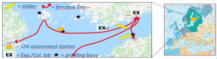
The JERICO-S3 project is funded by the European Commission’s H2020 Framework Programme under grant
       agreement No. 871153. Project coordinator: Ifremer, France.

2. INTRODUCTION
Environmental Research Infrastructures (RIs) are designed to provide long-term sustained
observations and information products to scientific and other user communities, helping them
to understand and manage the grand environmental challenges such as climate change,
biodiversity loss or food and water security, to name a few. Because the Earth systems are
dynamic and heterogeneous, observations must be made at multiple locations to adequately
cover the diverse conditions of the ecosystems. The optimal design of the RI network should
reflect the heterogeneity of the regions and the complexity of the systems studied, as well as
the full size of the area under study (Hari et al 2016). In addition, RI must cope with economic,
political and logistical challenges, and must optimally also have interfaces with other RIs and
other related observation structures and initiatives.
Environmental RIs promote the integration, interoperability and coordination of observing
systems. Hari et al. (2016) introduced a conceptual design that included three connected
hierarchical levels of observatories, called Stations (mostly referring to a specific platform or
permanent site), and provided examples of atmospheric, forest ecosystem, and ocean RIs. In
their concept, the Standard Stations provide measurements for basic characteristics of the
system, while the Advanced Stations also provide flux measurements. Both types are vital for
RI to expand the spatio-temporal coverage of observations. The most advanced layer, the
Flagship Stations in Hari et al. (2016) concept, operate as multidisciplinary sites with high
diversity of observations, good capacity for ancillary mission-type operations, and connectivity
with other RIs. Such concept of Flagships Stations, or Supersites, to name it differently, has
already been introduced in many environmental RIs as discussed in Section 2.1.
The concept of a “Flagship Station” or hereinafter referred to as the “Supersite” requires
careful consideration and proof-testing before it is launched in coastal areas. The first iteration
of the definition of the coastal Supersite concerns the scope of the concept and is discussed
in Section 2.2. The study of coastal systems often requires several observations at appropriate
temporal and regional scales. Thus, the challenge for coastal Supersite is how to
simultaneously address the requirements for in-depth multidisciplinary environmental
information and coverage of relatively large spatial scales. As no single site or platform cannot
meet such challenges, coastal Supersite need to provide a multiplatform sampling strategy
and involve the required spatial coverage. The next challenge to be met is how such a
multiplatform Supersite concept for coastal seas can be designed to serve a wide range of
research questions and uses. Phenomena studied in many sea areas transcend national
borders and in such cases Supersite logistics must be transnational, which can be challenging
to implement.
The aim of JERICO-S3 WP4, “Pilot Supersites for innovative coastal monitoring” is to provide
a proof of concept for coastal Supersites, to study how the coastal observations are best
integrated, for provision of sustained multidisciplinary observations (Section 2.3). The actions
to be piloted include new institutional and organisational collaboration schemes, making the
Pilot Supersite partnership to work in concert and to provide consistent regional data, services
and products for various uses. Pilot Supersites will interface with regional user communities,
demonstrating the added value of integrated actions. Linking with other regional actions,
especially with modelling and ocean colour communities and other RIs, will provide new
knowledge on the requirements for integrated coastal data and products. Pilot Supersites will
also iterate how the linkages between Supersites and other observatories should be optimally
built-up for various coastal regions, and how communication between Supersites need to be
structured, to meet pan-European requirements for high impact coastal observations.

                                                    Reference: JERICO-S3-WP4-D4.1-06.05.2021-V2.1
                                                                                        Page 7/99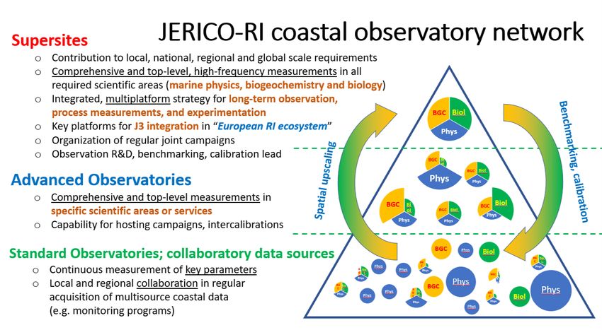
The JERICO-S3 project is funded by the European Commission’s H2020 Framework Programme under grant
        agreement No. 871153. Project coordinator: Ifremer, France.

2.1. Supersite concept in Environmental RIs
The term Supersite[1] is a widely used term in atmospheric, terrestrial, geological and satellite
research observatory networks (Google Scholar search). But since there is no general
definition for the term Supersite, in the context of the JERICO RI Supersite is considered a
highly instrumented and permanent observatory with harmonized and standardized
measurements and a high capacity (quality and quantity) for observations. Supersites use
state-of-the-art technology to conduct high-impact research and serve as a test bench for new
approaches (Hari et al. 2016, Karan et al. 2016). The spatio-temporal scale of Supersites must
cover the phenomena studied, and they must be optimally located to allow comparison across
different ecosystems (Karan et al 2016). The territorial coverage of Supersites is quite case-
specific, as there is a trade-off between the extent of regional coverage and the
comprehensiveness of the data collected, and these need to be balanced for each issue
examined.
The Group on Earth Observations (GEO) uses Geohazards Supersites aiming to improve
geophysical scientific research and geohazard assessment in support of Disaster Risk
Reduction (https://geo-gsnl.org). On the other hand, the Committee on Earth Observation
Satellites     (CEOS)     uses    Supersite   to   specify  satellite  validation  sites
(https://lpvs.gsfc.nasa.gov/LPV_Supersites/LPVsites.html).
Supersites in the EU atmospheric aerosol observing network EUSAAR (European Supersites
for Atmospheric Aerosol Research, http://www.eusaar.net/) were identified based on the high
level of implemented instrumentation for multivariable study of atmospheric aerosols and on
their atmospheric probing capacity in an identified environment. Nowadays, EUSAAR
continues its activities in ACTRIS (Aerosols, Clouds, and Trace gases Research InfraStructure
Network, http://actris.net/).
In terrestrial ecosystems networks (Australian, US, Canadian, European considered here)
the concept of “Supersite” (often called Master Site) is defined as spatial foci for long-term
observation of phenomena, status, biodiversity, processes and function of an ecosystem
(White et al. 2019). They are also considered as highly instrumented, permanently operated,
sites where all ecosystem compartments and fluxes are covered including experimental
approaches aiming at gaining insight into mechanistic processes (Fisher et al. 2011). They
cover multiple variables and may concern a specific spatial scale, volume of infrastructures,
availability of long-term data, interdisciplinarity level and age of observatory
(www.supersites.tern.org.au; Musche et al. 2018). These sites are grouped under the Long-
Term Ecosystem Research (LTER) network umbrella. LTER studies drivers of ecosystem
change at various sites, classified in three levels: (i) master or supersite, (ii) regular, (iii)
emerging, extensive or pilot. Master (or Supersite) LTER Sites are permanent and highly
instrumented sites which are strategically designed to the ecosystems they represent
(https://www.lter-europe.net/lter-europe/infrastructure/sites-platforms/categories).
In marine observatory networks the terms used up to now appear to refer to a multiplatform
“autonomous system” that is a subcomponent of a national (or international) network,
addressing a specific local question/process as well as some across common themes. A
“regional coastal node” in the Integrated Marine Observing System (IMOS,
https://imos.org.au/nodes) of Australia, addresses a specific local science question, which is
integrated into a larger multidisciplinary framework linking the open ocean and shelf/coastal
components and addressing five major research themes across the Nodes (IMOS National
Science and Implementation Plan). These nodes share a common data network and are
connected to terrestrial, freshwater, geological and atmospheric science communities. In the

[1] Another term designating a similar concept to Supersite are Flagship stations, mastersite, topsite, LTER hub,
research array and node. However, caution should be given as, in other cases, hub and node may refer to a
different notion

                                                         Reference: JERICO-S3-WP4-D4.1-06.05.2021-V2.1
                                                                                             Page 8/99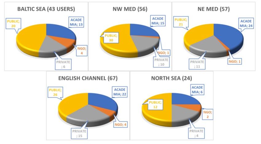
The JERICO-S3 project is funded by the European Commission’s H2020 Framework Programme under grant
        agreement No. 871153. Project coordinator: Ifremer, France.

US, a similar concept of “Coastal Arrays” (also called “Node” in older documents) is used by
the Ocean Observatories initiative (OOI) to refer to a multiplatform (fixed and mobile) system
addressing several of the major OOI themes (e.g. ocean atmosphere exchange, climate
variability, ocean circulation and ecosystems) and a specific regional process (e.g. upwelling,
shelf-slope exchange) (Trowbridge et al. 2019, www.oceanobservatories.org).
In EU marine related RIs the Supersite concept is not yet used to our knowledge. The EU
river-sea system RI, DANUBIUS-RI, uses the term Supersite as natural laboratories dedicated
to observation, research, modelling and innovation across the river–sea continuum at
locations of high scientific importance, selected to provide investigations in contrasting
environmental, social and economic systems (Bradley et al. 2017, www.danubius-pp.eu).
LifeWatch-ERIC is working towards such a concept (communication by LifeWatch-ERIC CEO
C. Arvanitidis). Other marine RIs and RI-projects, like EMSO-ERIC, EMBRC-ERIC, EURO-
ARGO ERIC and EUROFLEETS+ are based largely on a network of nodes, single sites or
platforms.

2.2. Concept of JERICO Supersite
Within the coastal seas, because of the perpetual flux of the ecosystem, interactions between
physical and biological dynamics do not take place in a fixed position but generally within the
mesoscale - in horizontal scales up to tens to hundreds of kilometres – with embedded 3-D
sub-mesoscale processes at various, nested spatiotemporal scales. A coastal sea Supersite
must therefore encompass integrated and harmonized multiplatform measurements, the
combination of which is able to yield adequate horizontal coverage and vertical resolution.
Supersites in coastal seas are thus in essence regional and transnational, and a network of
Supersites is envisioned in the future to connect major European coastal sea regimes to jointly
answer environmental and societal challenges (See section 3.1). Within this context, we
elaborate the concept of JERICO Supersites below.

The JERICO Supersite is a regional (or sub-regional) coastal marine observatory. As marine
observatories are considered[2] infrastructures dedicated to multiple in situ observations (from
air–sea interface to seafloor interface) at appropriate spatiotemporal resolution, in a restricted
geographical region[3], maintained over long timescales[4], and designed to address
interdisciplinary objectives, driven by science and society needs (Crise et al. 2018; Petihakis
et al. 2018).

JERICO Supersites have the following key features

    ●   High spatial density of multiple observing platforms offering the required
        spatiotemporal resolution to study phenomena at nested spatio-temporal scales up to
        mesoscale
    ●   Multi-interface coverage (land-sea, air-sea, offshore-coastal, pelagic-seafloor) via well-
        established links to other RIs and addressing, in collaboration with other RIs, themes
        (common being defined by the RI) at global and regional levels as well as to specific
        local requirements
    ●   Multidisciplinary and interdisciplinary activities with scientific excellence
    ●   Multivariable and adequate spatiotemporal coverage (i.e. required resolution) of
        essential ocean variables (EOV). Multivariable coverage of essential biodiversity
        variables (EBVs)

[2] The term “marine observatory” may have various meanings (Crise et al. 2018)
[3] For JERICO-RI Regional to sub-regional coastal areas
[4] For JERICO-RI an observatory is “long-term” if it has >10 years operations and dataflows

                                                        Reference: JERICO-S3-WP4-D4.1-06.05.2021-V2.1
                                                                                            Page 9/99
The JERICO-S3 project is funded by the European Commission’s H2020 Framework Programme under grant
       agreement No. 871153. Project coordinator: Ifremer, France.

   ●   Transnational and transinstitutional character if necessary, to obtain full spatial and
       variable coverage
   ●   Generic platforms with capacity to adopt new technology (plug and play
       instrumentation & sensor web enablement), and acting as contact point to marine
       industries
   ●   Capacity to adopt new technologies and approaches
   ●   Centralised steering of observations
   ●   Part of an established (or under a roadmap) National RI
In addition, JERICO Supersites have the following characteristics supported by the JERICO-
RI.
   ●   Well-established research themes based upon local, national, regional and global
       requirements driven by science and society (following the Framework for Ocean
       Observing).
   ●   Shared, synoptic, interoperable, and openly available biological, biogeochemical, and
       physical data
   ●   Operational delivery of data to International (EU) portals
   ●   Coordinated and interoperable data management streams to International portals
   ●   Well established dissemination strategy, including joint dissemination products with
       other Supersites
   ●   Interoperability (including sharing) of platforms, equipment, knowledge, products, tools
       and services
   ●   Common design and implementation of missions with other Supersites and other
       JERICO observation systems and sites
   ●   Fully documented harmonized procedures and best practices
   ●   Well established links to users, especially in science, society, industry and policy
   ●   Products provision jointly with:
           ○ related Services (e.g. CMEMS) and Regional initiatives
           ○ National and EU RIs related to interfaces of land-sea, air-sea, offshore-coastal,
               pelagic-seafloor
           ○ Remote sensing and operational modelling communities
           ○ other Supersites and other JERICO observation systems and sites

2.3. Overall objectives of JERICO Pilot Supersites
The coastal observation platforms are scattered across the European coastline, largely based
on national and regional initiatives, but to some extent also linked together for answering large-
scale science questions. JERICO-S3 project studies how these structures may be developed
further in JERICO-RI, aiming to develop a network of harmonized and extensive observational
capabilities for major European coastal sea regimes. JERICO-RI envisions that the final
coastal observation network consists of three levels of observatories, Supersites, Advanced
observatories and Standard observatories, which are differentiated by their capacities to
provide observations (Figure 1). While Supersites aim to provide holistic and top-level high-
frequency measurements in all required scientific areas, using integrated multiplatform
strategy for long-term observations, the Advanced observatories provide comprehensive and
top-level measurements in specific scientific areas or services. Standard observatories
provide continuous measurements of some key parameters, often for local or regional needs.
All observational levels are needed, they have complementary roles and their differences are
not always obvious.

                                                    Reference: JERICO-S3-WP4-D4.1-06.05.2021-V2.1
                                                                                       Page 10/99
The JERICO-S3 project is funded by the European Commission’s H2020 Framework Programme under grant
agreement No. 871153. Project coordinator: Ifremer, France.
Figure 1. Illustration of JERICO-RI coastal observing facilities. Supersites enable integrated pan-
European observations of complex multidisciplinary research questions. Advanced observatories
provide high level integrated observations for specific questions. Standard observatories target more
the regional and national questions for some key parameters.
JERICO-S3 will provide a practical proof of concept for JERICO-RI Pilot Supersites (PSS) at
four coastal regions (see Section 3). PSSs operate sustained, multidisciplinary and integrated
observation platforms at high technological readiness levels (TRL 7-9) addressing several
specific Key Scientific Challenges (see Section 3.1). PSS data flows are established, and data
products are developed. Using a series of Actions, transnational collaboration, access and
governance are explored and tested (see Section 4). PSS operations are used to compare
and evaluate various practices for the integration and interoperability of diverse observation
platforms designed for a range of different scientific topics and societal challenges in coastal
ecosystems. Interoperability and harmonization between specialized observation platforms is
tested at a high technological readiness level. In addition, PSSs will provide practical
collaboration-platforms to meet other RIs and observation initiatives. The demonstration of the
feasibility of PSSs includes two years of integrative work with observations and their
transnational management.
A Pilot Supersite complies with most of the Supersite key features (with the capacity to satisfy
all) and is aiming to fully satisfy all supersite criteria (Table 1). This is done by:
A) Formulating the regional role of PSSs
● defining and prioritising of key societal information needs regarding regional marine
environments (regionalization and prioritization of Grand Challenges)
● defining and prioritising of key scientific gaps in observing the regional coastal
ecosystems, as required by various users
● analysing the coastal observatories operating in respective regions outside the PSS
partnership
B) Demonstrating
● the added values of integrated, state-of-the-art multidisciplinary, multivariable, and
multiplatform observation capabilities,
Reference: JERICO-S3-WP4-D4.1-06.05.2021-V2.1
Page 11/99The JERICO-S3 project is funded by the European Commission’s H2020 Framework Programme under grant
agreement No. 871153. Project coordinator: Ifremer, France.
● how the sub-components are optimally operated when studying complex coastal
challenges in an integrated approach,
● how interactions with other environmental RI networks can be regionally organised
● how the interactions with modelling and satellite remote sensing communities are
regionally implemented
● how PSSs can upgrade, harmonise and sustain observations and products that are
usable for various societal and scientific needs
● how to transnationally share and manage platforms and equipment, and plan joint
missions,
● how to jointly manage the whole data lifecycle, following the FAIR principles
● how to increase the societal and scientific value of observations through data fusion
and integration,
● how to transfer knowledge within the region, between regions, and between RIs.
C) Establishing
● harmonized communication & jointly steering operations between-PSS
● jointly agreed best practices and QA/QC protocols for observations and data streams
● links to other Supersites, observatories, environmental RIs (including joint studies),
maritime industries, and regional initiatives of environmental management of coastal
ecosystems
● common objectives, when possible, related to coastal biology and biogeochemistry
such as carbon budget/carbonate system, effects of rare/extreme events,
phytoplankton biodiversity and productivity etc.
● an optimum, innovative monitoring and science strategy
● joint dissemination plans
● joint communications with key regional stakeholders
D) Evaluating
● PSS implementation phase as input to the planning phase of JERICO-RI
● new technologies and new sensor packages
● self-evaluation using metrics of implementation, performance, data delivery and impact
E) Improving
● cost-efficiency, innovative use and scientific and societal impact of observations
● links to users, especially in science, society, maritime industry as well as in regional
environmental management and policy
● provision of Transnational Access and Virtual Access
● data flow, QC practices, coverage of Regional EOVs and EBV and operational delivery
of data for all variables to International (EU) portals
● Merged access to derived new products
● validation of model results and ocean colour data
Reference: JERICO-S3-WP4-D4.1-06.05.2021-V2.1
Page 12/99The JERICO-S3 project is funded by the European Commission’s H2020 Framework Programme under grant
agreement No. 871153. Project coordinator: Ifremer, France.
Table 1. Criteria for JERICO-RI Pilot Supersites and those for final JERICO-RI Supersites
Criterion PILOT Supersite Supersite
Specific environmental characteristics and/or Existing Well defined and addressed
society needs
Multi-platform at high spatial density Existing capacity Coverage at required resolution
Multi-scale coverage up to mesoscale
Multi-interface coverage (land-sea, air-sea, Existing capacity Full coverage via well-established
offshore-coastal, pelagic-seafloor) links to other RIs
Multi-variable coverage (EOVs and EBVs) EOVs at coverage EOVs and EBVs at required
higher than resolution
surrounding areas
Multi-disciplinary and interdisciplinary Existing Joint with other (sites, RIs etc) and
activities with scientific excellence enhanced via Supersite approach
Generic platforms with capacity to adopt new Existing Valid for all platforms
technology
Shared, synoptic, interoperable, and openly Partly operational Operational delivery for all
available biological, biogeochemical, and delivery for most variables
physical data. Data delivery to International variables
(EU) portals
Products Existing and With a Supersite added value. Joint
delivered to products with other Supersites,
international portals initiatives and RIs
Local, national, regional and global Capacity to reply all Common and well-established
requirements four levels themes driven by science and
society. Addressing all levels via
links to other RIs
Centralised and harmonised management Within PSS Well established within and
(optional) between Supersites
Sharing of platforms, equipment, knowledge, Existing Centralised management and well-
products, tools, services defined conditions
Common mission design and implementation Existing (optional) Well established
Transnational and/or Transinstitutional Mandatory, if necessary, to obtain full spatial and variable
character coverage
Procedures and practices Existing within the Harmonised and fully documented
PSS and common with other Supersites
Dissemination Existing plan at PSS Well established strategy among
level (optional) Supersites with joint products
Supersite is part of one or several National Established or under Established National RI
RIs a National roadmap
Communication between Supersites Existing (Optional) Well established
Communication with Integrated Regional Existing (Optional) Fully established at least with
Sites (IRS) geographically adjacent IRSs
Links with marine, river, terrestrial, Existing (Optional) Well established. Joint products
atmospheric RIs
Links with Remote Sensing community Existing Well established. Joint products
Links with Operational Modelling community Existing Well established. Joint products
Trans-sectoral links (Coastal SMEs) Existing (Optional) Well established partnerships.
Connections to Local and Regional Existing (Optional) Well established
monitoring programs
Links to Services/Initiatives (CMEMS, Existing Well established. Joint products
EMODnet, GOOS, GEO,…)
Reference: JERICO-S3-WP4-D4.1-06.05.2021-V2.1
Page 13/99The JERICO-S3 project is funded by the European Commission’s H2020 Framework Programme under grant
agreement No. 871153. Project coordinator: Ifremer, France.
3. SCIENCE STRATEGY FOR PILOT SUPERSITE
IMPLEMENTATION
The conceptual design of the future JERICO-RI network for coastal areas, including the
Supersites, must consider the advice of past and ongoing RIs plans and be adapted to the
specificities of coastal ecosystems. The specific challenges faced by coastal RIs that need to
be considered in planning relate to the complexity of coastal ecosystems and the huge number
of scientific issues involved (sections 3.1-3.3). Coastal RI has several domain-specific
interfaces (terrestrial, atmospheric, open ocean) with other RIs (section 3.4) and involves
many user communities (sections 3.4, 3.6) that need to be considered. The proposed RI
structure must reflect the already established local, national and regional observation
structures, but recommend changes as necessary to ensure the impact of RI at the regional
and pan-European level (sections 3.4-3.5). Finally, the proposed design should improve
existing activities, especially in filling the contemporary gaps in multidisciplinary data provision
for user needs (section 3.7).
3.1. Key common scientific questions within JERICO-S3
JERICO-RI will address a large diversity of scientific, environmental and societal issues. The
Key Scientific Challenges (KSC) are divided in three subgroups and they are elaborated in
detail in the JERICO-S3 WP1, especially in the Deliverable D1.1.
1. KSC#1: Assessing and predicting the changes of coastal marine systems under the
combined influence of global and local drivers
2. KSC#2: Assessing the impact of extreme events on those changes
3. KSC#3: Unravelling the impacts of natural and anthropogenic changes
As a background information for the existing regional observation capacities, we have
analysed the observational capacities of European coastal regions to tackle the KSCs of
JERICO-RI (Tables 2 and 3). The regional analysis is based on sub-selection of European
coastal regions which are represented by the contemporary JERICO-RI community. These
regions include the JERICO-RI Pilot Supersites and Integrated Regional Sites (IRS, dealt
within JERICO-S3 WP3, see Deliverable D3.1), selected to explore in practice the
transnational and transinstitutional integration of observations within JERICO-S3, especially
providing a proof of concept and feasibility. In order to analyse how JERICO regions have their
observational capacity fit-for-purpose to answer the key scientific questions (as identified in
JERICO-S3 D1.1), an exercise based on the self-evaluation by JERICO-RI experts for each
coastal region is presented in Tables 2 and 3. It is worth noting that, although the expert
assessment was carefully conducted, the precision of results may still be improved for some
questions (like more harmonization of the answered categories from Very Good to Not known).
We opted to follow the basic rule of ranking the regions based on their best examples. This
analysis can be useful as a starting point to define which science questions can be answered
using existing observations within each region, and to identify clear gaps in the observations.
Reference: JERICO-S3-WP4-D4.1-06.05.2021-V2.1
Page 14/99The JERICO-S3 project is funded by the European Commission’s H2020 Framework Programme under grant
agreement No. 871153. Project coordinator: Ifremer, France.
Table 2. JERICO-RI internal expert assessment of the observational capacities in the different
European coastal regions regarding the Key Scientific Challenges KSC#1 and KSC#2. The analysis
provides an overall overview of the maturity of the state-of-the-art observation system regarding the
different processes and or parameters.
Observations and data flows
NW Mediterranean Sea
Iberian Atlantic Margin
NE Mediterranean Sea
Very good
Kattegat-Skagerrak
Irish Coastal Seas
English Channel
Good
Norwegian Sea
Sicily Channel
Bay of Biscay
Adriatic Sea
Improvement needed
North Sea
Baltic Sea
Not needed
Not known
KSC1: Land-Ocean continuum: impacts of land-based discharges and exchange with open ocean
Nutrients
Particles and organic matter
Inorganic carbon
Litter and contaminants
KSC1: Sea-Atmosphere interface: quantification of inputs
Particles
Nutrients
Contaminants
KSC1: Connectivity and transport pathways of water masses and materials
Within region
Between other coastal regions
Between region and open ocean
Within region retention dynamics
KSC1: Biodiversity trends
Phytoplankton
Zooplankton
Benthos
KSC1: Ecosystem biogeochemical processes and interactions
Pelagic
Benthic
Pelagic-benthic coupling
KSC1: Carbon budget and carbonate system
Carbon fluxes and budget
Carbonate system trends
Effects of acidification
KSC2: Impact of rare and extreme events
Floods
Storms, large waves
Heat waves
Landslides, sudden erosion
Harmful algae blooms
Pollution due to accidents
Reference: JERICO-S3-WP4-D4.1-06.05.2021-V2.1
Page 15/99The JERICO-S3 project is funded by the European Commission’s H2020 Framework Programme under grant
agreement No. 871153. Project coordinator: Ifremer, France.
Table 3. As Table 2, regarding the Key Scientific Challenge KSC#3
Observations and data flows
NW Mediterranean Sea
Iberian Atlantic Margin
NE Mediterranean Sea
Very good
Kattegat-Skagerrak
Irish Coastal Seas
English Channel
Good
Norwegian Sea
Sicily Channel
Bay of Biscay
Adriatic Sea
Improvement needed
North Sea
Baltic Sea
Not needed
Not known
KSC3: Long term observations to resolve Climate Change impacts
Temperature
Salinity
Currents
Sea level
Waves
Biological production
Species distribution ranges
Nutrients
KSC3: Observations to resolve impacts of various anthropogenic disturbances
Eutrophication
Habitat and biodiversity loss
Contamination
Coastal engineering
Use of marine space
Use of marine nonliving resources
Use/cultivation of living resources
Invasive species
Maritime traffic
Underwater noise
KSC3: Interoperable and integrated long term data sets
Biogeochemistry datasets
Biodiversity datasets
JERICO-RI observation capacity covers a wide range of topics, as illustrated in Tables 2 and
3. The analysis shows JERICO-RI strengths in covering most of the topics in various coastal
regions. But of course, the capacities vary between regions and between Key Scientific
Challenges and their subtopics. These gaps need to be analysed further and prioritised to
guide the future developments.
The analysis above (to be elaborated in detail in JERICO-S3 D1.1) provides the background
for development of JERICO-RI Supersites. It gives the first indications, which are scientific
and societal elements to be included in the first iteration of Pilot Supersites.
Reference: JERICO-S3-WP4-D4.1-06.05.2021-V2.1
Page 16/99The JERICO-S3 project is funded by the European Commission’s H2020 Framework Programme under grant
agreement No. 871153. Project coordinator: Ifremer, France.
3.2. JERICO-S3 Pilot Supersite regions
In JERICO-S3 project, four locations are selected as PSSs; the Gulf of Finland (GoF PSS),
the North-Western Mediterranean (NW-MED PSS), the North Sea and English Channel
(NSEA and CHANNEL PSS), and the Cretan Sea (CRETAN PSS). These sites will collect the
first-hand experience on the organisational (transinstitutional, transnational etc.), data flow,
and research challenges of the concept, in order to formulate an ambitious, but realistic
framework for building a geographically representative array of integrated Supersites for
JERICO-RI, as an outcome of the JERICO-S3 project. This activity is done in parallel with
another integrative action, as JERICO-S3 WP3 is working towards networking of existing
coastal observing activities and initiatives at several other coastal regions (called as Integrated
Regional Sites, IRS). PSS and IRS actions will be streamlined throughout the JERICO-S3
lifetime and transfer of knowledge is done during joint workshops. It is expected that PSS
networking actions will contribute to the development phase of JERICO-RI and the
experiences will be directly communicated towards JERICO-DS -project.
European coastal ecosystems vary, as do the regional organisation of observations. To gain
sufficient knowledge how JERICO-RI Supersites need to be constructed, in the planning
phase of JERICO-S3 it was decided that the number of PSSs to be experimented need to be
large enough to cover different conditions and practices within pan-European coastal regions,
but due to economic and practical reasons the number of sites need to be constrained. Thus,
the PSSs represent a fraction of JERICO-RI partnership and observation capacities, but the
whole network will benefit from the shared experiences gained in the PSSs. It was further
decided that each PSS starts with a relatively small number of partners and platforms, and
thus with somewhat limited geographical and scientific focus. This initial constraining of PSSs
was done to guarantee the focus on well-defined objectives for each PSS. Within each PSS,
a clear coordination role was assigned for one partner. The aim of this decision was to ensure
a consistent flow of information from PSS partners to WP and project coordination.
The actual selection of PSS sites was an iterative process (for requirements see also Table
1). It was expected that PSS has an existing, continuously operated, and sustainable
multiplatform RI. They were requested to have documented measurement capability for
physical, biogeochemical and biological variables in spatiotemporal scales allowing analysis
and modelling of their interactions. In addition, they need to have a documented observation
data delivery to European data portals. For their region, they should show good capacity for
transinstitutional and transnational integration of activities, when needed for specific scientific
questions and links to regional actors in satellite remote sensing and modelling communities.
It was further expected that PSSs have an adequate coverage of the currently defined EOVs
and at least the potential to cover EBVs. Finally, it was requested that PSSs have
demonstrated or convincing potential for regional interaction with other RI networks.
The four PSS regions selected are briefly introduced below (see Figure 2). While two of the
PSS regions (the Gulf of Finland, and the Cretan Sea) represent relatively condensed actions
at sub-basins of the Baltic Sea and the Eastern Mediterranean Sea, the North-Western
Mediterranean PSS, covers the regional sea area more comprehensively. The fourth region
(combination of the North Sea and English Channel) is even larger, and it also studies how
the neighbouring PSSs could collaborate and streamline observations, practices and actions.
Such a diversity of PSS scales allows us to draw conclusions, which are the desired regional
scales of Supersites and how the optimal scales may vary between regions and scientific
topics.
The description of PSS regions highlights the similarities and differences in their scientific
topics and objectives. Based on these identified communalities and specificities, objectives for
PSSs were selected, as identified in the follow-up sections.
Reference: JERICO-S3-WP4-D4.1-06.05.2021-V2.1
Page 17/99The JERICO-S3 project is funded by the European Commission’s H2020 Framework Programme under grant
agreement No. 871153. Project coordinator: Ifremer, France.
Figure 2. JERICO-S3 regions for Pilot Supersites
The main characteristics of the five sea areas (a subselection from Tables 2-3), which the PSS
regions cover entirely or are subpart, are presented below together with their specific scientific
topics and objectives.
The NORTHEASTERN MEDITERRANEAN SEA (to which the Cretan Sea is a subpart) is an
ultra-oligotrophic basin of the Mediterranean Sea, and it acts as a heat, salt, and oxygen
reservoir. The area is characterized by multiple scale circulation patterns and intense
mesoscale variability. In the region, vertical mixing leads to intermediate and deep-water
formation. It is a hotspot of biodiversity; however, biodiversity long-term data sets are still
limited. There is also sparseness of carbonate system data, to understand its role as source
or sink of CO2. As the other parts of the Eastern Mediterranean, the region is vulnerable to
disturbances by invasion of alien species due to proximity to the Suez Canal. The northern
part (North Aegean), is affected by material transport (nutrients, contaminants) from the Black
Sea, large cities and rivers. In the southern part, atmospheric deposition is the main source of
nutrients in the euphotic zone, other than the vertical mixing of water during winter. However,
their exact contribution to the balance of nutrients and the resulting impact on productivity
remains uncertain.
Specific regional scientific topics and objectives.
• Insight into the role of the NE Mediterranean Sea as source or sink of CO2.
• Effects of the upper general circulation seasonal and interannual variability (in particular,
the Black Sea waters) on the thermohaline circulation of the Aegean Sea.
• Resolve the coupling of intermediate and deep-water formation with biochemical
functioning.
• Monitor and assess the impacts of river inputs and the effect of Black Sea waters on
marine ecosystems
• Investigate the climate change effects on marine productivity and biodiversity through
warming, acidification, nutrient-oxygen dynamics and extreme atmospheric events.
• Study the contribution of mesoscale activity to the general circulation of the Aegean Sea
Reference: JERICO-S3-WP4-D4.1-06.05.2021-V2.1
Page 18/99The JERICO-S3 project is funded by the European Commission’s H2020 Framework Programme under grant
agreement No. 871153. Project coordinator: Ifremer, France.
• Contribute to societal demands like protection of marine environment from pollution (e.g.
oil spill accidents) and support for handling coastal erosion.
The NORTH WESTERN MEDITERRANEAN basin is one of the most dynamic regions in the
Mediterranean Sea. In this area, the intense open sea convection, shelf water cascading
events, storm and flood events, occurring in wintertime, affect the distribution of sediments,
nutrients and organic matters in the land-to-sea continuum and all over the water column. In
addition, the subsequent intense spring bloom represents the most important biological
process of the basin which impacts the carbon exports. The main drivers of these dynamic
processes are the winds forcing and the cyclonic circulation, which is characterized by an
intense boundary current, the Northern Current (NC), flowing from the Italian to the Spanish
coasts. The general circulation of the NC is affected by seasonal variability as well as synoptic
processes and constitutes an important dynamic barrier between the open sea and coastal
waters.
Specific regional scientific topics and objectives.
• Study the effects of Northern Current (NC) transport: water mass circulation, particles
and plankton species, plastics, contaminants
• Evaluate the impact of major rivers inputs (on ecosystems) in the coastal area (Ebro
and Rhône Rivers)
• Study the shelf water cascading events: dense water formation, organic and
contaminants plumes
• Assess the occurrence of extreme events, like storms (Medicane), flash flooding, and
heavy rains.
• Understand Big cities impacts on e.g. eutrophication and contaminants
The ENGLISH CHANNEL is a shallow inter-regional coastal continuum influenced by the
Atlantic Ocean and the North Sea. The physical configuration (bathymetry, coastline) gives
rise to specific hydrological structures (fronts, gyres) that control advection and dispersion and
affect transboundary fluxes of nutrients, pollutants and plankton. In terms of hydrodynamics,
the most outstanding feature is the tidal current intensity. The region is also strongly impacted
by swells and waves coming from the Atlantic or generated locally by wind events. The system
is largely affected by the riverine input of freshwater, nutrients and particulate matter. These
hydrological and biogeochemical conditions are favourable for intense development of
seasonal primary production that can be locally associated with eutrophication issues and
harmful algal blooms. The region represents a significant economic zone where several
human activities take place: tourism and leisure, international ports and freight associated with
an intense maritime traffic and the exploitation of living (fisheries, aquaculture) and non-living
resources (marine aggregates).
Specific regional scientific topics and objectives.
• Advance the use of regional data in the WFD and MSFD implementation, and in
accordance with OSPAR Science Agenda and Assessment Procedure (Eutrophication);
contribute to improving ecological status assessments.
• Facilitate knowledge exchanges and sharing between RIs on land-sea continuum.
• Identify gaps in observations (sampling resolution, optimized parameters list considering
EOVs and EBVs, QA/QC procedures, data processing, etc) to move forward an
Integrated Observation System (Physics, Biogeochemistry & Biology) at the English
Channel level.
• Sort out the spatio-temporal variability of pressures controlling phytoplankton dynamics
(incl. biomass and productivity), from the local to the regional scale, and including
eutrophication, climate change and extreme events issues.
• Assess the spatio-temporal variability of SPM dynamics, especially related to hydro-
meteorological forcing, continental inputs, biophysical interactions and human activities.
Reference: JERICO-S3-WP4-D4.1-06.05.2021-V2.1
Page 19/99You can also read