The Maritime Heritage of Waterford Estuary - An Overview of Heritage Features & Opportunities - Port of Waterford
←
→
Page content transcription
If your browser does not render page correctly, please read the page content below
The Maritime Heritage
       of Waterford Estuary

An Overview of Heritage Features
& Opportunities         Naomi S. Foley   APRIL 2021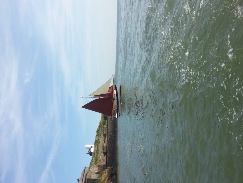
The Maritime Heritage of Waterford Estuary

2   An Overview of Heritage Features & Opportunities
The Maritime Heritage of Waterford Estuary

Foreword
For centuries rivers have been the motorways of the world. Waterford’s geographical position has meant that the harbour
has been one of the main gateways to Ireland for people and ideas since prehistoric times. Some of the first people to settle
in Ireland came through Waterford Estuary and evidence of their activities has been discovered by archaeologists at places
like Creadan Head and along the banks of the River Suir. Indeed, there is evidence of early settlements all along the shores
of Waterford Harbour.

It was the Vikings who established the port town here in 914, calling it Vedrarfjordr (haven from the windy seas) which over
time changed to Waterford. The city’s strategic importance is well illustrated by its part in the Anglo-Norman invasion of
Ireland and especially when Henry II sailed into Waterford Harbour in 1171 making Waterford a royal city. Following the
Anglo-Norman invasion of Ireland, William Marshal built a lighthouse on Hook Head in the 1200s and this is now the oldest
working lighthouse in the world.

By the 1200s the port city of Waterford was a wealthy and sophisticated place. Exports included wool, hides, wheat, oats, malt
and salted fish and imports included salt and luxury goods such as wine, figs, dates and silk. From medieval times Waterford
City Council claimed jurisdiction over the entire harbour and for centuries the village of Passage East was regarded as part
of the city.

The 18th century saw the expansion of Waterford port. The area prospered through the export of agricultural produce,
especially salt pork, salt beef and butter, much of it destined for Newfoundland. The increase in trade also saw the development
of several vibrant communities in the harbour especially at Cheekpoint, Passage East, Ballyhack, Duncannon and Dunmore
East. In fact, for many years larger ships anchored at Passage East and it was from here that many thousands of people left
Ireland to work in the Newfoundland cod fisheries.

A regular passenger, cargo and mail packet service operated between Waterford Harbour and Wales from 1750. In the early
years the ships stopped at Cheekpoint with passengers and mail transferred to Waterford by coach. With the wider use
of steam power and dredging of the navigation channels, most ships eventually made their way right up into the city of
Waterford, docking at the city’s quays. The service from Waterford to Wales continued until 1966 on the Great Western, a ship
that is fondly remembered.

In the 19th century some of the most important shipyards in Ireland developed at Waterford, first of sailing ships, then
steamships. The very first sailing ship to import tea directly into Ireland from China was built at White’s shipyard. Five
transatlantic steamships were built for the London-Le Havre-New York lines at the Neptune shipyard in Waterford. As well
as building, crewing, and providing supplies for the ships of the day, the estuary was also fished since the earliest times. The
recent fall off in salmon fishing was a devastating economic blow to villages like Cheekpoint, Passage East, Ballyhack and
Duncannon.

Port of Waterford wants to help ensure the skills of the people are passed on for future generations and also support the area
by promoting opportunities to develop the economic wellbeing of these beautiful estuarine villages. This report gives us a
very full account of how the villages on both the Wexford and Waterford sides of the estuary became such vital cogs in the
trading success of Waterford City and laterally how fishing became central to the villages’ economic wellbeing. In this report
Dr Foley also highlights the opportunities that exist to develop sensitive tourism initiatives and community projects that will
maintain the boat building, fishing and maritime skills developed over centuries. In commissioning and championing this
report, Port of Waterford wants to acknowledge the role Cheekpoint, Passage East, Duncannon, Dunmore East, Ballyhack and
Arthurstown played in the economic growth of the area. In doing so we also hope we can help promote the wonderful history
of Waterford Estuary and through tourism and community support enhance the villages aesthetically and economically.

In 2005 and 2011 Waterford hosted the Tall Ships Races and on each occasion over 80 majestic sailing ships thronged the
city’s quays attracting hundreds of thousands of visitors from around the world. The undoubted highpoint of these festivals
was the spectacular ‘parade of sail’ down the River Suir and passing by the historic sea-faring communities of Waterford
Harbour and out onto the high seas.

Once again Waterford and its harbour communities reclaimed its well-deserved title – Waterford of the Ships.

Des Whelan
Chairman
Port of Waterford.

                                                                                 An Overview of Heritage Features & Opportunities   3
The Maritime Heritage of Waterford Estuary

    About the author:
    Dr Naomi S. Foley is a marine resource economist. She obtained her PhD in economics from NUI Galway before
    undertaking post-doctoral research studies at the Norwegian College of Fishery Science, University of Tromsø and
    SEMRU, NUI Galway. She has extensive research experience in areas of fisheries and ecosystem management,
    bioeconomics, natural resource economics and ecosystem services. She has worked on EU multidisciplinary research
    programs, Norwegian Research Council projects and has carried out consultancy projects for public and private bodies.
    She has published in leading peer reviewed journals, book chapters and reports. Naomi is a native of Duncannon
    and now lives in Galway. She has a keen interest in all aspects of the sea. She enjoys being in, on or near the water,
    particularly sea swimming and surfing.
    Contact: naomifoley@gmail.com

    Acknowledgements: Many thanks to members of the estuary community for their input and valuable feedback. Thanks
    are also due to those that provided the photographs that have been used throughout this report.

    Images Copyright: Tomas Sullivan, Danny Ahern, Brendan Grogan and Francis Gannon. Remaining images are authors
    own.

    Commissioned by: Port of Waterford

4   An Overview of Heritage Features & Opportunities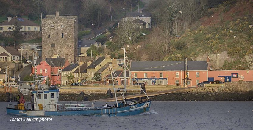
The Maritime Heritage of Waterford Estuary

Table of Contents

1.   Introduction												6

     1.1   Purpose and Objectives of the Study 							6
     1.2   What is Maritime Heritage?     								6
     1.3   A Collation of Maritime Heritage of Waterford Estuary 					7
     1.4   Heritage and Community Regeneration		          						9

2.   Waterford Estuary – Area Description 								10

     2.1   Location and Setting 									10
     2.2   Socio-Economic Overview									11

3.   Waterford Estuary – Natural and Cultural Heritage							13

     3.1   Natural Heritage										13

		3.1.1           Seascapes										13
		3.1.2           Biodiversity 									14
		3.1.3           Threats to Biodiversity and Seascapes 						16

     3.2   Cultural Heritage										19

		3.2.1           Traditional Fisheries 								19
		3.2.2           Traditional Boats									22
		3.2.3           Built and Vernacular Maritime Heritage						24
		3.2.4           Maritime Archaeology 								28
		3.2.5           Maritime Transport and Trade								30
		3.2.6           Recreation and Tourism Amenities							32
		3.2.7           Intangible Cultural Heritage								34

4.   Opportunities and Implementation									36

     4.1   Overarching Opportunities									37

		4.1.1           Maritime Heritage Centre								37
		4.1.2           Community Boatyard and Clubhouse							37

     4.2   Interaction, Co-operation and Collaboration   						39

		4.2.1           Funding Opportunities 								40

Appendices													42

A1 Description of Waterford Estuary Villages									42
A2 Proposed Template for Inventory of Boats									43
A3 List of Vessels Built at Carrolls Boatyard 1968 - 1986 							44
A4 List of Maritime Related Buildings from NIAH and SMR							45

                                                          An Overview of Heritage Features & Opportunities   5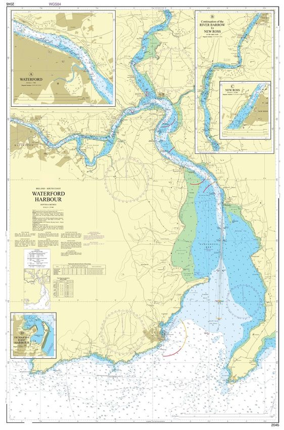
The Maritime Heritage of Waterford Estuary

    1.		 Introduction
    Recognised through the centuries for its strategic and economic location, natural attributes and resources, Waterford
    Estuary has a rich maritime heritage. It includes a diverse range of flora and fauna and varied seascapes, some of which
    are of international and national importance; a built heritage including forts, lighthouses and piers; and shipwrecks
    dating to the 16th century. The area has a long history in shipping and fishing and much of the heritage has evolved
    from these two industries. It is a gateway to the Barrow, Nore and Suir rivers and offers safe and scenic cruising grounds.
    The estuary provides a natural public amenity including an attractive coastline and beautiful beaches to be enjoyed by
    all. Connecting all of this is the intangible cultural heritage of Waterford Estuary; place names, skills, knowledge and
    stories. The maritime heritage of the estuary holds great cultural and natural importance for many and contributes to
    the identity of the estuarine community.

    1.1		       Purpose and Objectives of the Study

    The Harbour is shared by a range of estuarial stakeholders and activities including fishing, leisure, tourism, and
    commercial activities. The Port of Waterford Masterplan 2019 – 2044 seeks to set out a balanced and sustainable menu
    of potential actions across all of the Port’s activities. The plan includes aims to implement specific community projects
    or sponsorships, preserve and protect biodiversity and cultural heritage, minimise coastal erosion, adaptation to climate
    change effects, maintain water quality and support sustainable development1.

    This report was commissioned by Port of Waterford to provide an overview of the natural and cultural heritage of
    Waterford Estuary. It catalogues the maritime heritage features of Waterford Estuary and outlines opportunities for the
    future sustainable development, promotion and preservation of this heritage that could benefit the estuary community.
    It aims to:

          •     Increase awareness of the maritime heritage of Waterford Estuary
          •     Contribute to a sense of community, pride and place through sustainable social and economic development
          •     Strengthen and build on current community development projects such as those funded by FLAG and LEADER
          •     Promote preservation and enjoyment of maritime heritage2

    1.2		       What is Maritime Heritage?

    Maritime heritage has cultural, physical and ecological dimensions. It embraces the legacies of past generations that
    derived a living from the sea, including their traditions, as well as natural features of coastal environments along with
    their associated plant and animal communities. From the definition of heritage in the Heritage Act, 1995, maritime
    heritage covers both terrestrial and water-based elements including fisheries, wildlife habitats, flora and fauna,
    seascapes, wrecks, coastal monuments and other features of archaeological interest or importance3. It also includes
    intangible heritage such as the naming of places and physical features, folklore, customs and beliefs, knowledge of the
    sea and traditional craftsmanship.

    Maritime heritage is at risk today from various pressures such as climate change, pollution, loss of traditional fishing
    methods and neglect. Heritage in all its forms should be treated with respect and care but it should also be enjoyed and
    experienced. Only through appreciation of our natural and cultural heritage can we ensure its preservation for now and
    for future generations4.

    1
     http://www.portofwaterford.com/corporate-documents#a-master-plan
    2
     This is also an objective within Ireland’s National Marine Planning Framework approved by Government March 2021.
    3
     Policy Paper on Conserving Ireland’s Maritime Heritage. The Heritage Council (2006).
    4
      Waterways Ireland Heritage Plan 2016 - 2020

6       An Overview of Heritage Features & Opportunities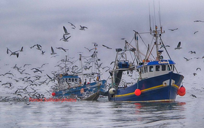
The Maritime Heritage of Waterford Estuary

1.3		    A Collation of Maritime Heritage of Waterford Estuary

The Heritage Council prepared a policy paper on Conserving Ireland’s Maritime Heritage in 2006. It advocated greater
recognition of our maritime heritage and the significant role heritage can play in the development of Ireland’s marine
and coastal resources. Using the Heritage Council paper as a guide to heritage features5, this report categorises and gives
a general overview of the maritime heritage of Waterford Estuary.

The classification of maritime heritage identifies a broad, deep heritage. It is neither an inventory nor a full evaluation
of the maritime heritage6. This report draws extensively from publicly available documents but does not attempt to
summarise them or represent all findings. Almost every section of the maritime heritage of Waterford Estuary warrants
further research and analysis. Table 1 provides a summary of the categories of maritime heritage in Waterford Estuary
and examples of each.

This report takes a holistic view of the estuary. There are topographical, environmental and historical differences along
the estuary. Each village has its own unique features. While the area is not a homogenous unit, it is all these features
combined that make Waterford Estuary an area rich in maritime heritage.

This report includes heritage features that are not included in the Heritage Council report.
5

There is a wealth of heritage on Waterford Estuary that is not maritime. This does not feature in this report.
6

                                                                                              An Overview of Heritage Features & Opportunities    7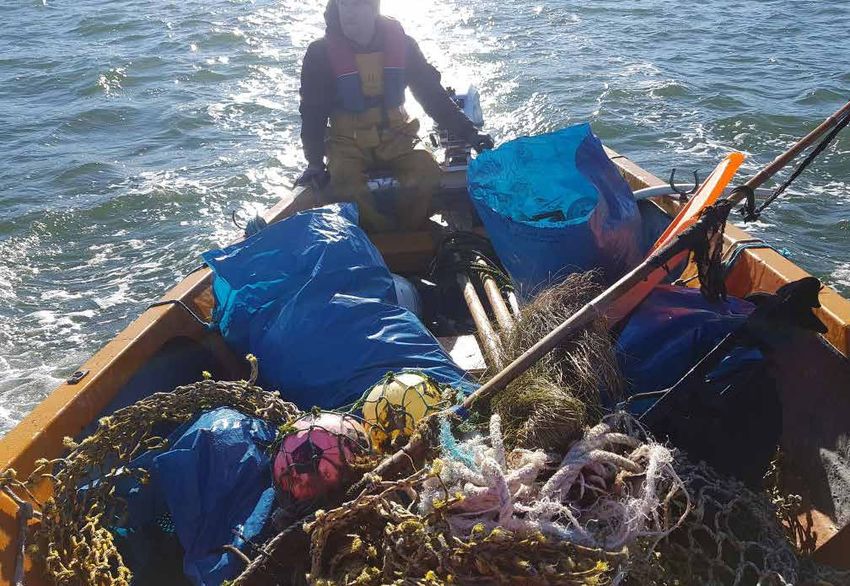
The Maritime Heritage of Waterford Estuary
Maritime Heritage Examples
Seascapes Strands
Bays
Cliffs
Caves
Woodland
Natural Heritage
Biodiversity Flora
Fauna
Ecosystems & habitats
Geology
Protected Areas SAC
pNHA
Threats to Natural Heritage Climate Change
Human Activities
Marine Litter
Water Quality
Traditional Fisheries Type: salmon, eel, herring
Methods
Skills
Community
Boat Building Ballyhack yawl
Punt
Prong
Estuary Regattas
Cultural Heritage
Built Heritage Lighthouses
Forts
Castles
Weirs
Martello Towers
Archaeological Heritage Forts
Ship wrecks
Marine Leisure Sailing and boating
Boat tours and angling
Walking
Swimming
Kite-surfing
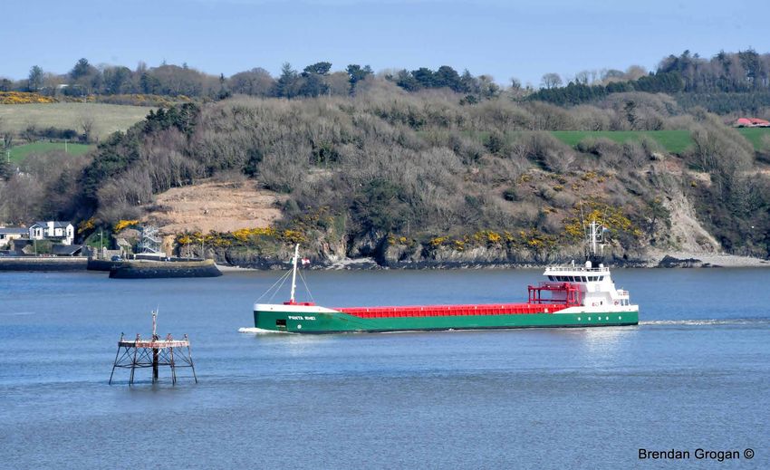
Shipping and Transport Port of Waterford
New Ross Port
Ferry
Trades e.g. hobblers, lightermen
Intangible Cultural Heritage Connected with many aspects of marine
heritage
Placenames
Stories
Table 1: Summary of Heritage Features in Waterford Estuary
8 An Overview of Heritage Features & Opportunities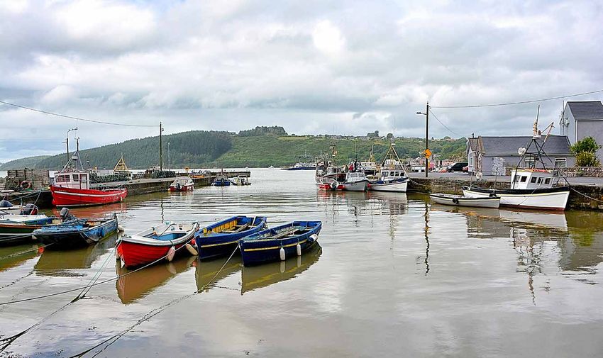
The Maritime Heritage of Waterford Estuary

1.4      Heritage and Community Regeneration

Seamanship and fishing have formed an important part of the estuary. Fisheries have faced a general decline and the
impact of this is evident in Waterford Estuary. The socio-economic review finds that unemployment rates in most of
the villages are above national average and the demographic structure reflects an aging population. Most of the villages
are below average with regard to deprivation. Heritage can be a strong driver for regeneration, making an important
contribution to community pride and sense of place. Maintaining and enhancing our heritage provides a basis for
local sustainable social and economic development. Within each category of maritime heritage this report identifies
opportunities that may provide the impetus for regeneration initiatives. Regarding the order in which opportunities are
presented, no priority is either intended or implied.

These opportunities can only be achieved through coordination and cooperation of all bodies including state agencies,
businesses, NGOs and the local community. Lacking at present is a community representative structure that can act as
an interface between the estuary community, local development bodies and national structures. A recommendation of
this report is for such a structure to be developed with representatives for each village as well as relevant stakeholders7.

Waterford Estuary has a diverse range of flora and fauna. There are three SACs in the estuary which form part of the
Natura 2000 network of sites under the EU Habitats Directive. They are designated because they offer core breeding
and resting grounds for rare or threatened species, and some rare natural habitat types. While these sites do not exclude
human activities, it must be ensured that they are managed in a sustainable manner, both ecologically and economically.

The next section gives an overview of estuary area, this is followed by the classification of maritime heritage. Finally
section 4 discusses the opportunities arising from the report and implementation.

In developing Fishery Local Action Groups committees were established to represent an area. It may be worthwhile investigating how these
7

were formed, lessons learned etc.

                                                                                         An Overview of Heritage Features & Opportunities   9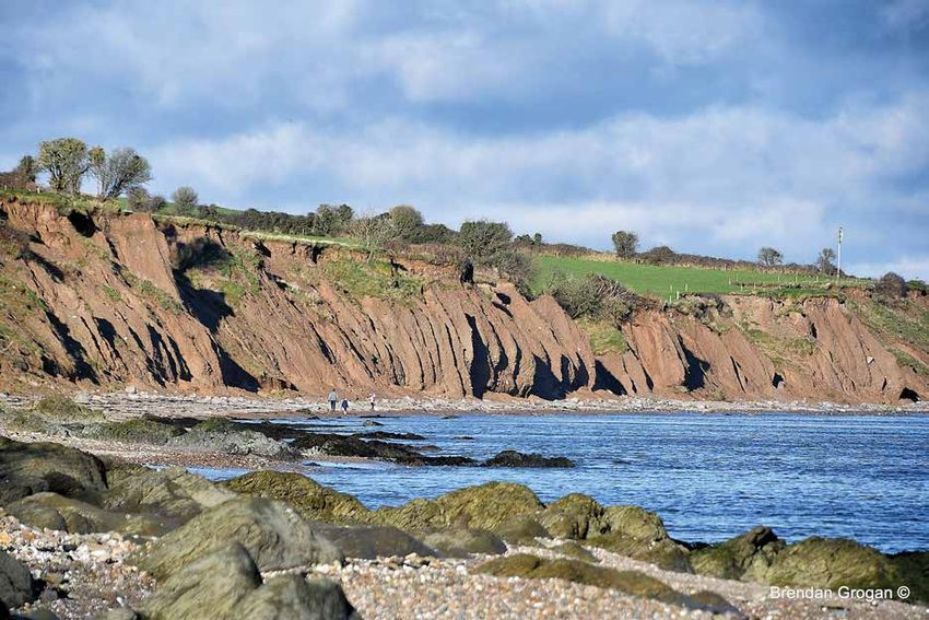
The Maritime Heritage of Waterford Estuary

     2.       Waterford Estuary – Area Description
     2.1      Location and Setting

     Waterford Estuary, made up of the combined waters of the rivers Barrow, Nore and Suir, is a naturally wide harbour
     that opens to the sea. The entrance to Waterford Harbour lies at the mouth of the estuary between Dunmore East and
     Hook Head. The entrance is approximately 2 nautical miles wide and marked on the west by Hook Head Lighthouse
     and a port buoy at the 10m CD contour to the east of Dunmore East. The marine access to the Port of Waterford is shown
     on Admiralty Chart 2046 – Waterford Harbour.

     The estuary comprises villages in both counties Wexford and Waterford. There are six villages on the estuary. Dunmore
     East, Passage East and Cheekpoint are located in Co. Waterford. Duncannon, Ballyhack and Arthurstown are located
     on the Wexford side of the estuary. The study area incorporates both sides of the estuary.

                                                                     Figure 1: Waterford Estuary Admiralty Chart. © Crown
                                                                     Copyright and/or database rights. Reproduced by permis-
                                                                     sion of The Keeper of Public Records and the UK Hydro-
                                                                     graphic Office (www.GOV.uk/UKHO)

10   An Overview of Heritage Features & Opportunities
The Maritime Heritage of Waterford Estuary
2.2 Socio-Economic Overview
Many coastal and fisheries areas are facing a general economic decline often combined with an aging population or
depopulation8. There are few fishermen left as younger people move to the cities to take advantage of better educational
and employment opportunities. The impact of these changes often goes beyond the fisheries sector, affecting also the
wider community. The result can be a downward spiral in both the local economy and service provision. The following
presents a socio-economic review of the villages on Waterford Estuary.
Waterford Estuary comprises five electoral divisions (ED); Killea (Dunmore East), Woodstown and Faithlegg (Passage
East & Cheekpoint) in Co. Waterford and Templetown and Ballyhack (Ballyhack, Arthurstown & Duncannon) in Co.
Wexford. At ED level the overall area is in line with national averages for 20169, with the exception of Ballyhack ED
which is below average.
However, it would be remiss to look at the performance of the estuary purely at the ED level. Both Cheekpoint and
Passage East are within an ED that contains some highly affluent areas resulting in an ED above average. At ED level
these two villages could go unnoticed in terms of their needs and economic status. By looking at the estuary villages at
the small area (SA) level it is possible to get a true picture of the socio-economic profile of the estuary villages10.
• The Pobal HP Deprivation Index measures the relative affluence or deprivation of a particular area using data
compiled from the national census. This index is based on three dimensions of affluence/disadvantage:
Demographic Profile, Social Class Composition and Labour Market Situation.
› Duncannon consists of two SA one of which and all of Ballyhack are considered disadvantaged in the
Pobal Deprivation Index
› Passage East, Cheekpoint, Duncannon and Arthurstown are below average with regard to deprivation
• Unemployment by village at the SA level shows a variance in unemployment rates with most being above
the national average. Both Arthurstown and areas of Dunmore East were below the census average
unemployment. Cheekpoint, Passage East, Ballyhack and Duncannon showed higher unemployment rates
than the national average.
• The demographic structure of the villages reflects an aging population. Relative to the State average of 13.4%
the estuarine villages have a much older population profile of residents aged 65+ ranging from 17% to 30%.
• There has been a growing improvement in the level of education amongst the adult population over the past
25 years throughout Ireland. In 1991, 36.7% of the population had primary education only. By 2016 this had
dropped to 11%. The same positive trend applies for third level education where the percentage of the adult
population with a third level education has grown significantly. In 2016 42% of the population had third level
education compared with 13.6% in 1991.
› For Waterford Estuary the SA level those with primary education only for 2016 ranged from 12%
(Cheekpoint) to 23% (Ballyhack).
› The villages on Waterford Estuary are defined by a lower level of adults with third level education
than the national average (42% in 2016) ranging between 12% and 30%.
8
Diversification of Fisheries Areas, Farnet Guide 5. European Commission Maritime Affairs and Fisheries.
9
This information is drawn from 2016 census data. The next census is due in 2022.
10
Dunmore is the largest settlement in Waterford Estuary. It is one of five national fishery harbour centres. It is made up of a number of small
areas. Overall Dunmore is marginally above average in terms of affluence and is inline with national averages.
An Overview of Heritage Features & Opportunities 11The Maritime Heritage of Waterford Estuary
The villages on Waterford Estuary are an example of the economic decline experienced by many fishing communities.
These villages have been traditionally dependent on fisheries activities as a source of employment, income and
community.
This initial analysis indicates that these villages warrant an economic stimulus to encourage local regeneration
initiatives, support social cohesion and sustainable development. Any such stimulus could embrace and utilise the
values, knowledge and skills of the fishing and maritime communities, thereby contributing to an improved sense of
community, pride and place.
12 An Overview of Heritage Features & OpportunitiesThe Maritime Heritage of Waterford Estuary
3. Waterford Estuary – Natural and Cultural Heritage
Estuaries (sometimes referred to as harbours) are partially enclosed bodies of water along coastlines where fresh-water
and salt-water meet and mix. They act as a transition zone between sea and land. At low water, there can be extensive
areas of mudflats or sandflats. Estuaries are important for many reasons:
• They are vital habitats for marine species including fish, birds, mammals, crustaceans, plants and algae
• They act as a buffer between the ocean and land, reducing the effects of flooding and storm damage
• They are economically important (e.g. shipping, fishing, angling and tourism)
• Estuaries are a popular recreational destination11
Waterford Harbour is rich in natural and cultural heritage with an interesting
and varied landscape. The cultural heritage includes traditional fisheries, boats
native to the area, fishing weirs, ship wrecks and buildings including castles,
piers and forts. It is an important nursery ground for many species of fish and
a natural shellfish production area. Waterford Estuary hosts a diverse range of
birds, a variety of aquatic and terrestrial mammals and is where the ‘Three Sisters’
rivers meet. There are three SACs in the estuary which form part of the Natura
2000 network and six proposed National Heritage Areas (pNHA). Waterford Estuary is also important for commercial
shipping providing access to the Port of Waterford and New Ross Port. It is a gateway to the Barrow, Nore and Suir
rivers and offers safe and scenic cruising grounds. The following presents the natural and cultural heritage of Waterford
Estuary.
3.1 Natural Heritage
3.1.1 Seascapes
Waterford Estuary is characterised by small fishing villages in proximity to bays, inlets, coves, cliffs and beaches. It has
a varying coastline including cliffs, mudflats, pebble and sandy beaches. Sea cliffs feature at both sides of the mouth
of the estuary. Sandy beaches are a feature of Waterford Estuary including Duncannon Strand, Woodstown Strand,
Passage Strand and Councillors. There are deciduous woodland fringes along the upper estuary. The Barrow Bridge
crosses two of the rivers, the Barrow and Nore, before they join the Suir downstream of the bridge. Where the Three
Sisters meet is known as Cumar na dTri Uisce (the confluence of the three waters). The combined waters of the Three
Sisters can be seen from Cheekpoint and flow out to sea through the Waterford Estuary.
Small secluded bays and inlets are dotted along the estuary. Many of these are not named on a map and names are
only known locally. The value of the seashore as a communal resource in the Hook led to creation of an intricate
system of coastal place names of complex origin12. These place names for the Hook Peninsula were mapped in 2004.
This covered the area from Hook Head up to Harrylock Bay. For the upper estuary, placenames have been mapped
from Cheekpoint to Ballyhack and Passage East13. As an intimate knowledge of the seashore is no longer necessary, the
names are becoming irrelevant and could eventually be forgotten. Place names along the estuary are being lost with the
passing of each generation and offer a unique insight into navigation, fisheries, shipping and other maritime heritage.
11
https://www.wit.ie/research/centres_and_groups/estuarine_research_group#tab=panel-1
12
Colfer, B. (2004). The Hook Peninsula, County Wexford. Irish Rural Landscapes: Volume II. Cork University Press
13
Before the Tide Went Out, p13, A Doherty (2017).
An Overview of Heritage Features & Opportunities 13The Maritime Heritage of Waterford Estuary
Opportunity
• Mapping of Local Place Names
Many bays have names known only to those that fished the area. If these are not documented, they will be lost.
Carry out a mapping exercise of all the bays, inlets, quays and local place names along the estuary. A detailed
local mapping of the entire estuary will build on work by A. Doherty (2017) and B. Colfer (2004).
3.1.2 Biodiversity
Biodiversity is the huge variety of plants and animals, from lichens to seaweeds, from insects to birds and mammals,
that characterise maritime ecosystems and the genetic variation in each species. Through its role in the construction
and maintenance of marine ecosystems, biodiversity provides natural goods and services that support human welfare,
and, ultimately, life on the planet14. Each marine or coastal habitat has its own plant and animal community. Many
species depend on more than one habitat for different stages of their life cycle.
Waterford Estuary has a wide variety of habitats and species some of which are of special conservation interest, by
virtue of being nationally or internationally important. Ecosystems and habitats include the estuary itself, intertidal
mudflats and sandflats, salt meadows, sea cliffs, open sea, beaches and shallow bays. Waterford Estuary hosts a diverse
range of birds, a variety of marine and terrestrial mammals and is an important nursery ground for many species of
fish. Protected species in the estuary include salmon and otter. Some of the best examples of honeycomb reefs can be
found on the estuary. There are also several important geological features in the estuary and a diversity of rock types
with oldest rocks belonging to the Cambrian period dating back approximately 500 million years. A variety of fossils
have been collected providing an important timescale and evidence of climate over time.
Habitats that are rare and threatened throughout Europe are listed under the EU Habitats Directive, which obliges
member states to designate Special Areas of Conservation (SACs) to protect them15. The Directive lists certain species
and habitats that must be protected within SACs. There are three SACs in Waterford Estuary:
• Lower River Suir SAC
• River Barrow and Nore SAC
• Hook Head SAC.
National Heritage Areas (NHA) are sites of national importance by reason of their flora, fauna, geological or physiographic
interest. There are no designated NHAs in the estuary. In addition to NHAs there are proposed National Heritage Areas
(pNHA). These are sites which have not been designated yet; there are plans to gradually designate them. They are sites
of significance for wildlife and habitats. These sites are subject to limited protection. pNHAs in Waterford Estuary are:
• Duncannon Sandhills
• Ballyhack
• Dunmore East Cliffs
• Hook Head
• Waterford Harbour and River Barrow as far as New Ross
• Creadan Head
Conserving Ireland’s Maritime Heritage, Heritage Council (2006)
14
https://www.waterfordcouncil.ie/media/heritage/Waterford%20County%20Biodiversity%20Plan.pdf
15
14 An Overview of Heritage Features & OpportunitiesThe Maritime Heritage of Waterford Estuary
The estuary is used by significant numbers of passage and wintering waders and waterfowl and is also important for
breeding seabirds. These include Black-tailed Godwits at the mudflats near Cheekpoint during winter. Cheekpoint
and Ballinlaw Marshes have sizeable populations of the recently colonising Little Egret. Little Island has a heronry of
national importance. The mussel bed off Passage East attracts Oystercatcher, Redshank and gulls. Large numbers of
Cormorants are often present offshore. Other species to the area include Ringed Plover, Lapwing, Turnstone, Common
and Black-headed Gull, Brent Geese, Red-breasted Mergansers, Great Crested Grebes, Bar-tailed Godwits, Sanderling,
Knot, Sandmartins, Water Rails, Sedge Warblers, Fulmar, Herring Gull, Kittiwake, Gannet and Razorbil16. Dunmore is
known for its kittiwake colonies. Brent geese are seen in numbers at Arthurstown Bay and along the shoreline from
Arthurstown to Duncannon. Kingfisher can also be seen in the upper estuary.
Fish species recorded include salmon, eel, mackerel, plaice, cod, sprat, smelt, lesser weaver, herring, goby and pipefish
to list but a few. Among these are internationally important fish species including Atlantic Salmon, European Eel and
European Smelt. Waterford Harbour is a Designated Shellfish Area and has also been identified as a shellfish growing
area by the SFPA. There are four distinct production sites as part of the mollusc production zone, they are at Cheekpoint
and Arthurstown (mussels); Woodstown (oysters) and Harrylock Bay (clams)17. Basking sharks can be seen off Hook
Head from April to July when they come to Irish waters to feed.
Among the marine mammals sighted in the estuary are common dolphin, harbour porpoise, bottlenose dolphin,
common (harbour) seal and grey seal. The availability of prey is one factor that draws species to an area. Large pods of
dolphins are observed in particular when shoals of sprat are in the estuary. Species observed outside of / at the mouth
of the estuary include; harbour porpoise, Risso’s dolphin, fin whale, long finned pilot whale, humpback whale and
minke whale. Terrestrial mammals include otter, badger, and fox.
Common invertebrate fauna include lugworm, sand mason worm, and common cockle. An extensive area of honeycomb
worm biogenic reef occurs adjacent to Duncannon. The honeycomb reef is created by a small worm (Sabellaria albeolata)
that lives inside small tubes that it builds from sand and shell. When thousands of these worms work together they can
form a massive reef along the coastline and form useful habitat for other marine life. Coastwatch Ireland has been
mapping the distribution of these reefs and have found the highest density in the South East to occur in Waterford
Estuary.
The dunes which fringe Duncannon Strand are dominated by marram grass. Other species include wild clary/sage, a
rare Red Data Book species. The rocks around Duncannon Fort have a rich flora of seaweeds and the cliffs themselves
support a number of coastal species on ledges including thrift, rock samphire and sea-buckthorn.
http://www.waterfordbirds.com/sites_wathbr.html
16
https://www.sfpa.ie/What-We-Do/Molluscan-Shellfish/Classified-Areas
17
An Overview of Heritage Features & Opportunities 15The Maritime Heritage of Waterford Estuary
3.1.3 Threats to Biodiversity and Seascapes
All of Ireland’s estuaries and coastal waters are impacted to some extent by human activities. Estuaries experience
siltation as a result of farming and construction upstream. Navigation channels and harbours have been deepened by
dredging, changing current patterns and communities of bottom living organisms. Fishing, particularly bottom fishing,
has in some places altered benthic habitats. Waters have also been contaminated from rivers, sewage disposal and the
atmosphere18. There is also the issue of marine and other litter being disposed of in waters.
Water Quality
The need to maintain water quality is key to conservation of biodiversity and water dependent habitats and species. Blue
Flag is an internationally recognised award for beaches, marinas, and sustainable boating tourism operators. In order
to qualify for this award, a series of stringent environmental, educational, safety-related and access-related criteria
must be met and maintained. To receive a Blue Flag a bathing site must, in addition to maintaining a high standard
of water quality, meet specified objectives with regard to the provision of safety services and facilities, environmental
management of the beach area and environmental education19. At beaches, the bathing water must comply with the
excellent standard in accordance with the 2006 EU Bathing Water Directive. For beach users, the Blue Flag award in
an important and well recognised indication of water quality. The 2020 Blue Flag Beaches on Waterford Estuary are
Dunmore Strand and Councillors Strand. New Ross marina also holds a Blue Flag.
Duncannon Strand held the Blue Flag from 1988 – 2007. It lost its status in 2007 due to poor water quality. Raw sewage
entering the water from two streams and run off from farms are two reasons that water quality has been on occasion
reported as poor. Bathing water quality is currently listed as ‘good’ by the EPA. The Duncannon Blue Flag Farming and
Communities Scheme, 2018 – 2021, is aimed at improving water quality and regaining the Blue Flag20.
In addition to Blue Flag, there is the Green Coast Award. The Green Coast Award recognises beaches of high
environmental quality; beaches must have excellent water quality and appropriate management to ensure protection
of the natural environment. Booley Bay is a current Green Coast beach.
Litter / Marine Stewardship
Litter found along coasts, beaches and in the water comes from a number of sources including: fly tipping, shipping,
sewage related debris, fishing and the public. Waterford County Council are currently working with local boat operators
to remove marine and other litter from otherwise inaccessible areas of the estuary. Boat owners with a familiarity of the
estuary, with representatives on the Wexford and Waterford side, are gathering litter and delivering it to a point for the
council to remove. They are also documenting the type of litter being found in the areas. It is a project funded through
FLAG21.
18
Policy Paper on Conserving Ireland’s Maritime Heritage. The Heritage Council (2006)
19
Beachawards.ie
20
There remains the issue of raw sewage. Construction is due to begin in 2021 on a new wastewater treatment plant with anticipated
completion in 2023.
21
Fisheries Local Area Action Groups
16 An Overview of Heritage Features & OpportunitiesThe Maritime Heritage of Waterford Estuary
Climate Change
In the marine environment, climate change impacts include increases in sea temperature, storm intensity, wave height
and sea level, as well as possible changes in ocean currents. Such changes may have profound implications for heritage
in the marine and coastal area.
Coastal erosion is evident throughout the estuary including Woodstown Strand, the sand dunes at Duncannon Strand,
Passage East and Booley Bay. Pacific Oyster and mussels are cultivated commercially at Woodstown Strand. The output
of this fishery is dependent on water quality and in recent years there has been a growing threat from reported increased
water temperatures at Woodstown22.
An increase in mean seawater temperature will affect species which currently occur at the extremes of their temperature
tolerance range, leading to northerly shifts in the range of plankton, enhanced recruitment of some species (e.g. bass)
and a decline in some wild populations (e.g. salmonoids). On a wider scale it will impact on biodiversity through species
losses, new arrivals and greater incidence of invasions of non-native species, for example rock oysters. Increased water
temperatures in shallow bays and inlets lead to changes in the structure and stability of plant and animal communities23.
McGrath, R. (2015). Waterford Estuary Area: A Community Led Mapping and Audit of its Natural and Heritage Resources
22
https://www.coastalheritage.ie/
23
An Overview of Heritage Features & Opportunities 17The Maritime Heritage of Waterford Estuary
Opportunities
Management, Monitoring and Maintenance
The marine environment provides a wide range of services which underpin health and wellbeing, regulate climate
and support fisheries, aquaculture, tourism and recreation. There are many impacts on the marine biodiversity and
ecosystems including pressures from fishing, climate change, habitat loss and pollution from land and sea based
activities. Establish a program of management, monitoring and maintenance to protect the ecosystem goods and
services provided by the estuary and establish an estuary that is aware of its marine environment
• River Rangers
Continue and develop the marine litter program established by Waterford County Council. This would involve
contracting fishers with a knowledge of the area to collect litter from the estuary only accessible by boat,
compensating for expenses and time. The work involved would include recording the type of litter collected and
location. As well as keeping the estuary free of litter and debris, the rangers would also closely monitor the area for
coastal erosion, pollution and other threats. Use this initiative to raise public awareness of the impact of litter on
the estuary and along coasts educating on the impact of litter on the marine environment, habitats, flora and fauna
and also on fisheries. In accessible areas, beaches, bays, coves, promote the Clean Coasts initiative and encourage
community involvement.
• Blue Flag and Green Coasts
Work with County Councils to achieve excellent water quality and environmental recognition. Strive to achieve
and/or maintain Blue Flag status at as many beaches as possible. Where beaches do not have the appropriate
infrastructure for Blue Flag, aim for Green Coasts Awards.
• Harnessing Fishers Knowledge to Maintain and Protect Biodiversity
With an intimate knowledge of the estuary, local fishers can make a valuable contribution to issues impacting
biodiversity and seascapes. Harness the knowledge, experience and resource base of the fisheries sector. This will
involve cooperation between fishermen and scientists for data collection and research. Work with local fishermen
and stakeholders to map and collect information on invasive species and observed changes in marine habitats,
ecosystems, flora and fauna.
• Raise Awareness of Waterford Estuary Biodiversity
Raise public awareness of marine biodiversity, assets and maritime heritage. Create information boards, leaflets
and displays to promote biodiversity. A recent FLAG funded project undertaken by Duncannon Village Renewal
designed information boards promoting biodiversity including information on birds, shore angling opportunities
and the biodiversity of rock pools and along the shore.
• Education
Develop a program to engage and educate people, particularly children and young people, in local marine biodiversity
and heritage Design information booklets and activity sheets, competitions such as crab fishing, and organise
educational tours on topics such as rock pooling, fossil hunting and all aspects of maritime heritage. Promoting a
greater understanding of the sea and its importance at a local and global level.
18 An Overview of Heritage Features & OpportunitiesThe Maritime Heritage of Waterford Estuary
3.2 Cultural Heritage
3.2.1 Traditional Fisheries
Dunmore is the main fishing port in Waterford Estuary and one of six designated national Fishery Harbour Centres
(FHC). Duncannon is the next most significant harbour for fish landings in the area. Fishing within the estuary includes
trawling for sprat, a small winter cod fishery, whelk and surf clam. There is also a fishery for razors which requires a
licence. The razor clam stock is distributed in two areas in Harrylock Bay and on the west side of the estuary at Creadan
Head. Aquaculture for oysters is carried out in Woodstown. There was a local mussel co-operative established in the
estuary but fishing no longer takes place due to mussel die back.
Traditionally fishing provided an important source of income for many households along the estuary. Fisheries that
were important to the estuarine community included drift netting for salmon and herring. Fishing for eel was carried
out in the upper estuary. The herring fishery at sea from Dunmore with mid-water trawls is also a part of the local
heritage and is well documented. Passage was also a significant location for the herring fishery. A fish house was built
in Passage East in 1901 for the curing of herring as well as the storing and sale of other fish. This onshore work was
predominantly carried out by women, initially requiring skilled labour, Herring Lassies came from Scotland to prepare
herring for process24. Women played a central role to the local fisheries, including the cockle women who picked cockles
along the estuary and transported them for sale.
There has been a decline in traditional fishing practices on the estuary as a result of efforts to preserve fish stocks. The
closure of the drift net salmon fishery and the eel fishery are two of the key issues that have affected the traditional
small scale estuarine fisheries. The herring fishery is also of cultural significance to the area. The following gives an
overview of the salmon and eel fisheries.
https://tidesandtales.ie/passage-east-fish-house/
24
An Overview of Heritage Features & Opportunities 19The Maritime Heritage of Waterford Estuary
Salmon Fishing
Salmon begin their lives in freshwater, migrate to sea as juveniles, grow to large size at sea and then return to their
native river to spawn and beget the next generation. They pass through estuaries on their way to sea as juveniles and
on their return from the sea as maturing adults25.
Commercial fishing for salmon was carried out using drift nets, draft nets or snap nets. In the estuary, from the Barrow
Bridge, drift-netting was used to catch salmon. Management was by way of commercial salmon licences issued by
SRFB (Southern Regional Fisheries Board – now Inland Fisheries Ireland / IFI) and season. The salmon fishery was
based in the harbours of Ballyhack, Duncannon, Arthurstown, Passage and Cheekpoint. Originally the season ran from
February to mid-August. With declining stocks, the drift net season was restricted both in duration (1st June -31st July)
and time allowed for fishing (4am to 9pm). A mandatory tagging and log book scheme was introduced in 200126.
In 2007 the introduction of single stock management for salmon led to the cessation of drift netting or any other form
of harvesting outside of rivers and estuaries. The closure of drift net fishing was supported by a government ‘Hardship
Scheme’ which allowed a voluntary buyout to all commercial salmon licence holders who held a licence for the 2006
season. The ‘Hardship Scheme’ was administered by BIM and the Regional Fisheries Boards. On accepting the Salmon
Hardship Scheme, a person is not eligible to apply for a future fishing licence should the fishery reopen.
The future harvest of salmon, by any means will be restricted to rivers, bays and estuaries, and to those stocks from
rivers that are meeting their conservation limit (CL). This means that there will no indiscriminate capture of fish. .
Commercial fishing and recreational angling can continue only on the scientifically identified exploitable surplus. For
Waterford Estuary this is dependent on the three rivers, Barrow, Nore and Suir, being above their CL27.
Eel Fishing
In the estuary study area, eel fishing was carried out in Cheekpoint. Little or no eel fishing occurred downstream of
Cheekpoint. Fishing for eel was by way of public licence. Baited eel baskets were used to capture eels during the months
April to September. Bait was captured using ‘sprat’ weirs. Baited baskets / pots were hauled twice daily to avoid heavy
predation by crabs.
In 2008, the eel fishery was closed under Ireland’s eel management plan. In consideration of the economic and social
impacts of Ireland’s Eel Management Plan, the eel support scheme fund was opened in 2018. The fund was made
available to former eel fishermen who were the holder of a State commercial eel licence or an eel fishing permit in the
2007 season (base year). The scheme provided payments to former fishermen based on their track record in the five year
period 2003-2007. The fund is now closed28.
25
Aztec Management Consultants
26
Collins, T., Malone, J. and White, P. (2006). Report of the Independent Salmon Group. Report to the Department of Communication, Marine
and Natural Resources.
27
www.fisheriesireland.ie; https://ec.europa.eu/competition/state_aid/cases/219787/219787_899282_4_2.pdf
28
https://www.fisheriesireland.ie/extranet/eels/1546-eel-fisherpersons-support-scheme-booklet-and-application-form/file.html
20 An Overview of Heritage Features & OpportunitiesThe Maritime Heritage of Waterford Estuary
A Way of Life
A loss of heritage, identity and skills is felt with the loss of these fisheries. There is a fear that the trades, skills and
craft of inshore fishing may come under threat and the culture, heritage and history of the industry could be lost29.
Skills lost include net mending, the role of wind, tide and season, boat building, boat handling and also the loss of
traditional fishing methods – drift netting for salmon and herring, fyke nets or baited traps for eels. It is also felt there
is a loss of community and camaraderie that came with the salmon fishery in particular30. Exacerbating these issues is
the age profile of the industry, the National Strategic Plan for the Fisheries Sector 2007 -2013 estimated that 51% of the
workforce was aged over 40 years.
Opportunities
• Explore the Establishment of a Heritage Fishery
In consultation with stakeholders, there have been suggestions of heritage fisheries as a means to maintain the
traditional fishing methods. Internationally, coastal places with strong fishing traditions have been diversifying
to Pesca tourism (fishing tourism). The concept is not clearly defined due to differing management and regulatory
measures by country. The proposal for a Waterford Estuary heritage fishery should be explored further. It would
need to include consultation with the relevant management bodies such as Inland Fisheries Ireland.
• Bass Fishing GhilliesG
Bass is a fish highly prized by all sea anglers. Estuaries, mudflats, steep to shingle beaches, sandy surf beaches,
rocky shores and headlands are all areas where bass can be found. There are reported increases in bass in Waterford
Estuary in recent years. There are a number of boat accessible locations for targeting bass in the area. Explore the
feasibility of establishing a ghillie/guide fishery with Inland Fisheries Ireland and other relevant bodies. The ghillie
would have extensive knowledge of the estuary and best fishing spots.
• Sharing of Skills and Knowledge
There is a fear that the skills and craft of the estuary fisheries may come under threat and the culture, heritage and
history may be lost. Develop workshops where the skills and knowledge associated with fishing can be passed on
to younger generations. This would include tides, weather and net mending. Boat handling skills would link with
building traditional vessels. Compensation should be provided to fishermen for the provision of training.
• Scientific Research and Monitoring
Fishermen’s practical knowledge of the sea and of the characteristics and behaviour of different marine species
can be invaluable when it comes to the collection of scientific data. IFI set up a Scientific Eel Fishery in which
fishermen’s local expertise and historical knowledge around eels in their area played an important role in the
project. It is increasingly recognised that the sustainable management of fisheries resources can only be achieved
with better cooperation, data sharing and mutual understanding between scientists and fishermen. This also links
with the opportunities identified in the previous section.
Irish Inshore Fisheries Sector Strategy 2019-2023, Inshore Fisheries Forum (2019)
29
Doherty, A. (2020). Waterford Harbour Tides and Tales. The History Press.
30
An Overview of Heritage Features & Opportunities 21The Maritime Heritage of Waterford Estuary
3.2.2 Traditional Boats
Changing patterns in fishing has led to a decline in the use of indigenous boats and official policy in relation to traditional
fishing methods has led to the disappearance of many of the smaller types31. Drift and draft netting of salmon, on which
many of the boatmen have traditionally depended, has been suspended since 2007 raising doubts about the future of
the small fishing boats in the estuary32. Several indigenous boats types have thus far survived in the Waterford Estuary.
Traditional boats include the ‘prong’, heavier caravel built estuarine punts and the ‘Ballyhack’ yawl.
Prongs, punts and yawls were a hallmark of Waterford Estuary. The have died out as the uses, and the men
who used them, have. They were culturally significant, if not unique and to lose them from the water is to my
mind a heritage loss
- Andrew Doherty, Tides & Tales
These are still in evidence throughout the estuary but are diminishing. Prongs are down to single numbers and traditional
sailing Ballyhack Yawls are down to last surviving examples.
Prong: The prong is closely associated with the Cheekpoint area of the estuary. It is a boat shaped like a halved bottle and
with a hull akin to a barrel. Like the currach, these keelless craft require experience in handling. The prongs principal
advantage is that it can be launched at all states of the tide, the round hull sliding easily across the mud banks of the
estuary. The prong can also float in only a few inches of water and can be poled over shoal banks and mud flats as
required33.
Punt: Carvel built punts are the most numerous type of working boat in the Waterford Estuary today. Punts can be found
in all of the small harbours of Duncannon, Arthurstown, Ballyhack and Passage, as well as Cheekpoint. Measuring
from 16 to 17 feet in length and about 5-foot beam, the punt is essentially a heavy duty rowing boat, fairly standard in
design, providing a stable work platform (traditionally for salmon drift netting). Long sweeps and outboards are used
for propulsion, but in former times they carried a spritsail. The spritsail was favoured as an auxiliary form of propulsion
because its mast was unstayed, and the sail could be rolled up around the mast and spar and stored out of the way when
shooting or hauling nets. In some of the older craft, the hole for the mast can still be seen in the forward thwart.
Ballyhack Yawl: A traditional yawl is a two masted sailing boat with a mizen and a main sail. In the 40s, engines were
fitted and the traditional ballyhack yawl was a type of fishing boat with the propellor coming out of its quarter to
facilitate the fishing of nets (salmon and herrings) in the strong tidal system of the Waterford estuary.
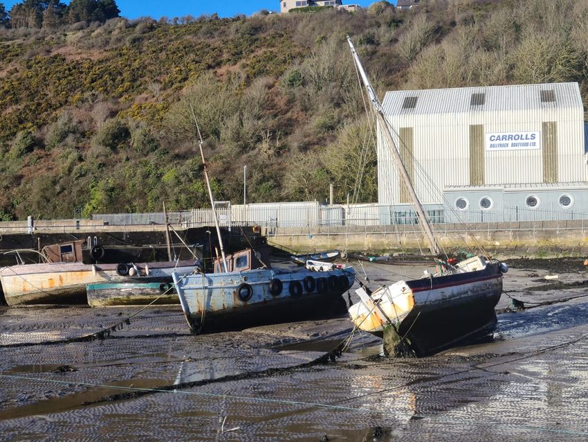
Boat Building
With the demise of traditional vessels, we also see the loss of traditional boat building and skills. Boat building was
carried out in most villages, the principal boats made being the punt or the prong in the upper estuary. The mid 1960s
to the 1980s Ireland saw a growth of local boat-building skills and small boatyards, including Carrolls’ Boatyard in
Ballyhack. The craft of timber boat building was developing as an area of skilled employment and considerable potential.
Between 1968 and 1981 approximately 30 half-deckers were built in Carrolls’, using larch on oak frames in a carvel type
design. The timber came from a variety of Irish forests and estates. In 1982, they began to build fully decked vessels,
36-feet long and capable of carrying up to eight tonnes. Demand dried up in the late 1980s and the boatyard stopped
building the traditional boat34. A list of the vessels built at Carrolls Boatyard from 1968 – 1986 is provided in Table 5
in the appendices. The business diversified to repair works, overhauls and refitting. From 1992 to the closure of the
boatyard in 1997 Carrolls refurbished the Trent class lifeboats from Scotland, England, Wales and Ireland for the RNLI.
Regattas
Regattas were a community wide event hosted by each village over the season as well as in Waterford and New Ross.
Participants were from all villages on the estuary. Boat classes included: Wag Race (the oldest one design dinghy in
existence); Yawl Race; Punt Sailing; Punt Open (pair-oared) and Punt (confined). Similar regattas are held presently in
Galway and all over South Connemara during the summer with the traditional Galway Hookers.
31
Policy Paper on Conserving Ireland’s Maritime Heritage. The Heritage Council (2006)
32
MacCarthaigh, C. (2008). Traditional Boats of Ireland: History, Folklore and Construction. Collins Press.
33
https://tidesandtales.ie/the-prong-curious-and-unique-boat-of/
34
https://www.irishtimes.com/news/the-rising-eu-tide-sank-a-lot-of-boats-1.100384
22 An Overview of Heritage Features & OpportunitiesThe Maritime Heritage of Waterford Estuary
Opportunities
• Inventory of Traditional Vessels
Ireland has a proud tradition in the design, construction and use of boats. The Heritage Council recommend that
although there have been successful initiatives in preserving and maintaining certain types of craft , there is much
to be gained from wider efforts to highlight and preserve boating traditions. They go on to suggest that it would be
beneficial to:
Record surviving traditional/heritage boats, including technical details, using standardised procedures;
record the collections and anecdotes of traditional boat builders and users to place boats in their proper
social and cultural contexts; preserve examples of heritage boat types afloat and in use and identify others
that may need to be conserved; encourage regional and local boat collections; develop and sponsor courses
in traditional boat building
This recommendation is very relevant to the boating heritage of Waterford Estuary. A first step would be to
carry out an inventory of boats in the estuary. A proposed inventory template is provided in the appendices.
• Waterford Estuary Traditional Boats Conservation Project
There is the opportunity for the rebuilding/restoration of a traditional yawl ‘The Ramona’. The project is currently
being explored. The Ramona is a 28ft yawl built in 1930s and used for salmon drifting and drift netting for herring on
Waterford Estuary. This may lead to further boat building and restoration opportunities. A community based boat
yard could encourage further restoration and building of traditional boats. The restoration of boats could be done
not only for reasons of heritage but also to promote boating in traditional craft and to provide an additional heritage
and tourism asset. FLAG has funded the building / restoration of prongs and punts previously.
• Explore the Feasibility Reinstating Summer Regattas
Explore the history of the estuary regattas and the feasibility of reinstating a summer regatta within the estuary.
This would be linked with maintaining traditional boats and also passing on boating skills to others. Regattas would
mean that the restoration of traditional vessels would become part of the estuary’s living heritage and culture, not
just museum pieces.
Similar regattas currently take place in the West of Ireland with the traditional Galway Hookers. The Galway Hooker
is a traditional boat distinctive to Galway Bay and the coast of Connemara. Once a utilitarian boat, used for fishing
and to carry many different goods, the Galway Hooker is now a leisure craft. These boats are also used for sailing
courses and trips along the coast of Connemara. Summer regattas are held in Galway and all over South Connemara.
Cruinniu na mBad annual festival celebrates the Galway Hooker and everything associated with it. Such festivals
and regattas are seen as important for the survival of the craftsmanship of traditional boat building, sail making
and skills. There is also a Galway Hooker exhibition in the Galway City Museum which tells the story of the
boat unique to the west coast of Ireland.
An Overview of Heritage Features & Opportunities 23You can also read