DRAFT FOR REFERENCE ONLY- not approved by the City - CITY OF READING DOWNTOWN 2020 MASTER PLAN
←
→
Page content transcription
If your browser does not render page correctly, please read the page content below
DRAFT FOR
  REFERENCE ONLY –
  not approved by the
  City

CITY OF READING
DOWNTOWN 2020 MASTER PLAN
CITY OF READING
DOWNTOWN 2020 MASTER PLAN

Prepared for
The City of Reading, Pennsylvania

Prepared by
Barry Isett & Associates, Inc.

August, 2011

Funding for this study was made available through the American Recovery and Reinvestment Act of 2009.
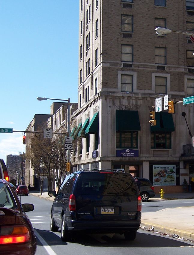
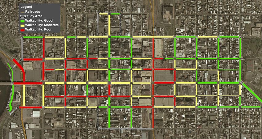
TABLE OF CONTENTS      1. Introduction

                       2. Understanding the Past

                       3. Analyzing the Present

                       4. Envisioning the Future

                       5. Conceptual Approach

                       6. Master Plan Recommendations

          Appendices   A. Existing Traffic Signal Permit Plans
                          Traffic Study Location Map
                          Downtown BARTA Bus Routes

                       B. Traffic and Pedestrian Count Figures

                       C. Level of Service and Queue Data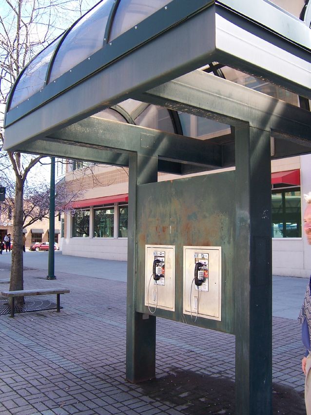
City of Reading • Downtown 2020 • Master Plan (DRAFT)
CHAPTER ONE: INTRODUCTION
In 2010 the City of Reading, together with several partners, initiated DOWNTOWN 2020 as a coordinated effort to
establish a unified vision for improving the quality of life in Greater Reading. This initiative is broad-reaching in its scope.
Ultimately it seeks revitalization of the City’s commercial core in order to create an environment that encourages economic
development and more attractive places for residents to live. This revitalization will rely upon improved infrastructure and
reinvestment incentives and strategies that heighten interest in living, working and playing in downtown Reading.
DOWNTOWN 2020 GOALS AND OBJECTIVES
The DOWNTOWN 2020 Master Plan focuses upon the physical conditions of public space within the downtown, with
a particular focus given to Penn Square and the Penn Street Corridor, and seeks to build upon previous plans and
development initiatives already underway. Specific goals and objectives of this master plan, as they relate to the broader
goals and objectives of the City’s initiative, are as follows:
Improve Physical Infrastructure
• Build upon Penn Corridor Development Plan
recommendations. This plan, completed in 2005
by Sasaski Associates, outlines a vision for
revitalization of the broader corridor extending over
two-miles between City Park in Reading through the
downtown area, across the Penn Street Bridge to
Penn Avenue, and extending through West Reading
and Wyomissing. Many of the objectives of this plan,
particularly within Wyomissing and West Reading,
have already been realized.
• Develop recommendations to strengthen the
physical identity of downtown Reading’s individual
commercial and historic districts.
• Focus on the revitalization of Penn Square as the
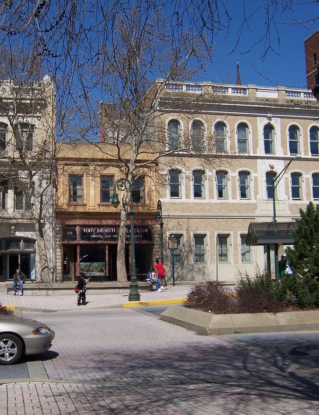
commercial center of the downtown and as a high Figure 1-1. View of existing streetscape along the 400 block
priority destination for both local residents and of Penn Street.
visitors.
• Develop recommendations that will encourage pedestrian activity in the downtown, with particular focus on
improving the safety of pedestrian crossings at key intersections.
• Develop design guidelines that will encourage a uniform aesthetic of the downtown’s streetscapes, to include
sidewalks and curbs, pedestrian lighting, street trees, wayfinding and informational signs, and street furnishings.
Improve the Reality and Perception of Public Safety
• Develop design recommendations that will increase the reality and perception of safety within the downtown,
particularly after dark, and on key pedestrian streets that connect Penn Square with other key nodes and
landmarks.
Develop Incentives that Encourage Reinvestment in Existing Properties
• Develop recommendations that will increase the value of existing and historic properties within the downtown, with
a particular emphasis on Penn Square.
• Propose locations for more on-street parking within the commercial core.
• Design streetscape development standards that will increase the livability of residential districts and the attractiveness
of commercial properties to new investment.
• Celebrate the history of downtown Reading as a means to promote heritage tourism.
Barry Isett & Associates, Inc. • August 2011 • Page 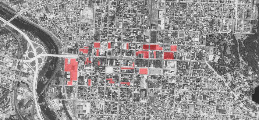
City of Reading • Downtown 2020 • Master Plan (DRAFT)

Develop Strategies for Living, Working, and Playing

•    Increase and diversify the mix of uses along the Penn Corridor, particularly within Penn Square.
•    Create public spaces within which pedestrians will feel comfortable (safe, clean, and green).
•    Through design, accommodate and encourage outdoor activities along the corridor (sidewalk cafes, outdoor
     markets, and special events).

PROJECT SCOPE AND STUDY AREA

In 2010. Barry Isett & Associates, Inc. (BIA) was commissioned by the City of Reading to prepare the DOWNTOWN
2020 Master Plan. This study is being overseen and coordinated by the DOWNTOWN 2020 Design Committee, which
is chaired by Mr. Lee Olsen, AIA. Funding for this study was made available through the American Recovery and
Reinvestment Act of 2009, which is being administered by the City of Reading’s Public Works Department. Members of
the Design Committee include:

•    Charles Jones, Director of Public Works, City of Reading
•    Glenn Knoblauch, Executive Director, Berks County Planning Commission
•    Andrew Miller, City Planner, City of Reading
•    Lee Olsen, Principal, Olsen Design Group
•    Kyle Zeiber, Manager, Reading Streets Department

It should be noted that chairman of the City of Reading’s Main Street Program Committee, Mr. Sam Loth, has also
attended Design Committee meetings on a regular basis.

The scope of work for this study included inventory and assessment of existing vehicular and pedestrian conditions
throughout the downtown to analyze how proposed streetscape improvements may impact the surrounding road network;
visioning—through design committee, key stakeholder, and public meetings; development of concept alternatives;
and the development of a draft and final master plan. A “Design Guidelines Manual,” which serves as a stand-alone
document, was also developed to provide details, material
specifications, and standards for future streetscape
improvements.

As a separate but related project, BIA also prepared final
construction plans and specifications for improvements to
the 500 block of Franklin Street. This construction will
serve as the “as-built” condition of the improvements
proposed in the Design Guidelines Manual for the
downtown’s residential streets.

DOWNTOWN PLANNING CONTEXT                                    Figure 1-2. The study area for the plan is bounded on the
                                                             east by City Park, on the west by the Schuylkill River, on
Downtown Reading is the commercial, cultural, and            the north by Walnut Street, and on the south by Chestnut
government center of Berks County. Founded in 1748           Street.
by the sons of William Penn, it boasts a rich tapestry of
historic buildings and open spaces woven together by an
urban street grid that extends between the Schuylkill River to the west and City Park (historically known as Penn’s
Common) to the east. Linked to the rest of the world by a sophisticated network of highways and rail lines, it lies less
than 90 minutes travel time from Philadelphia and less than three hours from New York City and Baltimore. With over
80,000 City residents and over 300,000 additional residents within the larger metropolitan area, downtown Reading has
all the basic ingredients needed to rehabilitate its commercial core and attract the economic investment that it desires.
Much has already been done towards this end, and it is important to note that this DOWNTOWN 2020 Master Plan has
been prepared within the broader context of other recent and ongoing planning studies and development initiatives that
indicate a tremendous amount of interest and investment in Reading’s rebirth.

Barry Isett & Associates, Inc. • August 2011 • Page 
City of Reading • Downtown 2020 • Master Plan (DRAFT)
Major Recent Development Projects
Major development projects over the last decade have included significant cultural, educational, commercial, entertainment,
and transportation initiatives within the City of Reading. The most significant are summarized below:
Sovereign Performing Arts Center: The Sovereign
Performing Arts Center serves as a venue for symphonic,
opera, ballet, popular music, and theatrical performances.
Located on North 6th Street, the center, which previously
served as the Rajah Theater, was renovated in 2000 by
the Berks County Convention Center Authority at the cost
of $7 million. Today it serves as the home of the Reading
Symphony Orchestra.
Sovereign Center: The Sovereign Center is a 7,083-
seat multi-purpose arena built in 2001 at the cost of $32
million. The arena, which is located along Penn Street
between 7th and 8th Streets, sits on the former site of
the Astor Theatre. Closed in 1975, the theatre sat vacant
until it was torn down in 1998 to make room for the arena.
The Sovereign Center is owned by the Berks County Figure 1-3. The Sovereign Center, which occupies the 700
Convention Center Authority. block of Penn Street, is a major multi-purpose arena that
draws thousands of visitors from all surrounding counties.
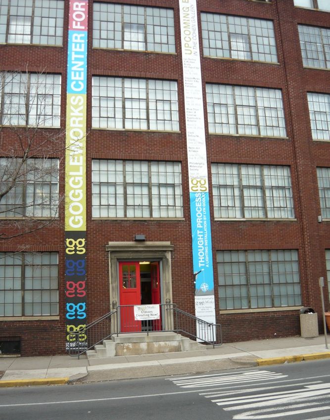
Goggleworks Center for the Arts: Opened in September 2005 at the cost of $13.5 million, the Goggleworks Center for
the Arts occupies a rehabilitated eyeglass factory at the corner of Washington and Second Streets. It has become a new
cultural center, offering independent films, galleries, and artist studios and workshops.
Sovereign Plaza: Completed in 2005 at the cost of $17.9
million, the Sovereign Plaza serves as the commercial
office complex of Sovereign Bank. Located at the corner
of 5th and Penn Streets, it contains 104,000 square feet
of office space and associated parking and is estimated
to house more than 500 employees.
Schmidt Training and Technology Center: Constructed
in 2006 by the Reading Area Community College (RACC) at
a cost of $10 million, the Schmidt Training and Technology
Center (TTC) provides classroom space for training in
advanced manufacturing skills, information technology,
market knowledge, executive senior leadership, business
performance, and workforce readiness. It is located
behind the Miller Center along Front Street.
Miller Center for the Arts: The Miller Center for the Arts,
located at the corner of 2nd and Penn Streets on the
campus of Reading Area Community College, is a 509-
seat theatre housing theatrical events. It was constructed
in 2007 for a cost of $16 million.
IMAX Theater and Parking Garage: In 2008, the IMAX
Multiplex Theater opened on the corner of 2nd and
Figure 1-4. Goggleworks Center for the Arts, located along Washington Streets. Constructed for a cost of $8 million,
the 200 block of Washington Street, is a regional cultural this theater features one IMAX screen and ten regular
center.
Barry Isett & Associates, Inc. • August 2011 • Page 
City of Reading • Downtown 2020 • Master Plan (DRAFT)

                                                                    screens. A 434-space parking garage was constructed
                                                                    directly across 2nd Street, on the southeast corner. It
                                                                    includes retail and restaurant space on the ground floor.

                                                                    Goggleworks Apartments: The Goggleworks Apartments
                                                                    is a six-story building currently under construction on the
                                                                    northwest corner of 2nd and Washington Streets. Initiated
                                                                    by Our City Reading, Inc., It is estimated to cost $13
                                                                    million. When complete, it will house 59 units that will be
                                                                    operated by the Reading Housing Authority.

                                                       Doubletree Hotel and Parking Garage: Constructed in
                                                       2011 by the Reading Parking Authority for a cost of $14
                                                       million, the seven-level, 929-space garage is intended to
Figure 1-5. The Miller Center, view looking south from serve the needs of Sovereign Center visitors, as well as
Second Street.                                         those who will be staying in the adjacent Doubletree Hotel,
                                                       which will be located across from the Sovereign Center on
                                                       Penn Street. The hotel is expected to begin construction
                                                       next year and cost approximately $65 million.

BARTA Transportation Center: Constructed by the Berks Area Regional Transportation Authority in 2002 at a cost
of $12 million, the BARTA Transportation Center (BTC) serves as a central transfer point for most bus routes and has
a passenger waiting area with an automated bus arrival and departure system. Situated on the 700 block between
Cherry and Franklin Streets, the terminal also houses a parking garage for monthly permit parking, a community police
station, and retail space along Cherry Street. The building
is designed for future second story office construction.

Franklin Street Station: Located at the corner of 7th
and Franklin streets. This historic train station served as
a Reading Railroad station until 1981 when passenger
service ended in the city. BARTA acquired the station
in 2005. Currently undergoing renovation, this historic
building will be rehabilitated as a BARTA bus terminal,
serving both regional and local routes. Some interior
space will be dedicated to the Reading Railroad Museum
to display and interpret historic artifacts. While still in the
feasibility planning stage, this station may also serve as
stop along an extended commuter rail line linking the City
to Philadelphia.                                                  Figure 1-6. The historic Franklin Street Station will soon be
                                                                  rehabilitated as a BARTA terminal.
Recent and Ongoing Plans

Act 47 Financial Recovery Plan: Despite the tremendous amount of capital investment in the downtown over
the last decade, the City of Reading is in a severe financial crisis. A few years ago the Mayor of Reading asked the
Commonwealth of Pennsylvania’s Secretary of the Department of Community and Economic Development to designate
the City as financially distressed under Act 47. In November 2009 the Secretary approved the distress determination,
saying the City’s “pattern of operating deficits is unsustainable and if left unabated will force the city to significantly
reduce or eliminate fundamental services that may adversely affect the health, safety, welfare, and quality of life of the
citizens.” As a result, in December 2009 the Secretary appointed a coordinator led by Public Financial Management, Inc.
to develop a financial Recovery Plan to bring the City back to fiscal health. Filed in the spring of 2011, the Act 47 Financial
Recovery Plan outlines several changes that are needed to foster economic development and growth in the City. These
include recommendations to bring short- and long-term revenues into balance, improve the efficiency and effectiveness
of its public services, and establish sustainable operating budgets. Among these, and relevant to this Master Plan, is the
recommendation that the City develop a local economic development partnership and comprehensive strategy that will
                                  Barry Isett & Associates, Inc. • August 2011 • Page 10
City of Reading • Downtown 2020 • Master Plan (DRAFT)
coordinate future development activities (as many of the recent development projects listed above were not directed or
coordinated by the City but rather by outside groups such as Our City Reading [OCR]). It is intended that this Master Plan
will serve as a blueprint for this group as it looks to identify and prioritize specific projects that will increase the City’s tax
base by attracting and retaining residents and businesses within the City limits
Penn Corridor Development Plan: The Penn Corridor Development Plan was commissioned by the Berks County
Economic Partnership in 2005. This plan, conducted by Sasaki Architects and the Brookings Institution, developed urban
design/development recommendations and marketing strategies to position the Penn Street Corridor as the main street
of downtown Greater Reading (to include Reading, West Reading, and Wyomissing). It stemmed from the 2004 Initiative
for a Competitive Greater Reading (ICGR), which recommended that the Penn Corridor be branded as a hospitality,
entertainment, and tourism corridor. This master plan builds upon its recommendations.
Riverplace Master Plan: The Riverplace Master Plan stemmed from a 2003 initiative to champion and coordinate
revitalization efforts along the Schuylkill River in Berks County. In 2004 the RiverPlace Development Corporation, a newly
formed non-profit corporation, together with the Schuylkill River Greenway Association (who is primarily responsible
for managing the Schuylkill River State and National Heritage Area) commissioned a master plan to create a vision
for riverfront redevelopment. Conducted by Sasaki Associates in 2006 and funded in part by a grant provided by the
Pennsylvania Department of Conservation and Natural Resources, the National Park Service, and the County of Berks,
this plan addresses the riverfront area between the Schuylkill Avenue Bridge (on the north) and Heritage Park (on the
south), extending approximately one-half mile inland on both sides of the Schuylkill River. Its recommendations include
a variety of new civic and private development initiatives within this area, including greenway trail extensions, open
space and park development, and streetscape improvements. The RiverPlace Development Corporation, whose board
is comprised of local government, business and civic representatives, continues to coordinate plans for the riverfront and
communicate these plans to the community at large.
Ride to Prosperity: Ride to Prosperity is an initiative of eight leading Berks County economic development and workforce
organizations who have come together to brainstorm and develop pathways to prosperity that can be put into place over
the next five years. Members include: The Berks County Industrial Development Authority, the Berks County Planning
Commission, the Berks County Workforce Investment Board, the Berks Economic Partnership, the City of Reading, the
Greater Berks Development Fund, the Greater Reading Chamber of Commerce and Industry, and the Greater Reading
Convention and Visitors Bureau. Initiatives are underway in the areas of Entrepreneurship and Innovation, Workforce/
Talent Development, Clusters, Sites & Infrastructure, and Quality of Place. Of particular relevance to this Master Plan is
the Quality of Place pathway, a hard to define term that identifies a place as special, memorable, and comfortable. The
Penn Corridor projects are viewed as supporting this initiative.
Reading Area Community College (RACC) Master Plan: The Reading Area Community College completed a Master
Plan for campus expansion in 2006 that is envisioned to accommodate needed changes through the year 2016.
Highlights of the plan recommend several major improvements and acquisitions, including the Fleetwood property and
the Competition Tire property (south of Franklin Street), which has already been done. Based upon recent discussions
with RACC administrative staff, other plan recommendations of relevance include:
Figure 1-7. Concept diagram for the Penn Corridor through downtown Reading. Source: Sasaki Associates, 2006.
Barry Isett & Associates, Inc. • August 2011 • Page 11City of Reading • Downtown 2020 • Master Plan (DRAFT)
• Converting the Chestnut Street Extension to extend Front Street and closing off Franklin Street to thru-traffic
between Front and 2nd Streets.
• Demolishing Berks Hall and replacing it with an updated academic building.
• Extending and strengthening the central pedestrian spine that runs north-south through the center of the campus
and providing traffic calming along Front Street, such as a boulevard and raised pedestrian crossings.
BARTA Transportation Development Plan Update: BARTA is the principal provider of public transportation services
in the City of Reading and Berks County. With an estimated ridership of 12,000 riders per day, hundreds of bus stops
, and over 20 transit routes, BARTA plays a major role in influencing pedestrian travel throughout the downtown. Work
is currently underway on BARTA’s Transportation Development Plan Update, which will analyze the BARTA system
and determine its future service. Plan highlights and relevant recommendations will be added to this summary as they
become available.
Related Initiatives/Programs
There are several organizations and special programs that currently play a major role in shaping Reading’s downtown
or have the potential to shape the future of the downtown. A summary of those most relevant to this study are provided
below:
Our City Reading: Our City Reading (OCR), led by Albert Boscov, is a 501c non-profit corporation that has been
responsible for many of the major new development projects within the downtown, including the Goggleworks Center,
the IMAX Theater, the Sovereign Plaza, the future Doubletree Hotel and Goggleworks Apartments, and many other
residential housing rehabilitation projects throughout the City. The organization’s mission is to spur revitalization of the
City and enhance the quality of life, create pride and stability through home ownership to Reading’s first time home
buyers, and bring new high quality job opportunities to the area.
Reading Main Street Program: The Reading Main
Street Program was authorized by an ordinance of City
Council in 2010 in order to maximize the efficiency of
existing City resources and create realistic momentum for
DOWNTOWN 2020 project completion. It is essentially
a reorganization of the Downtown 2020 Executive
Committee, and will oversee implementation of the
Downtown 2020 Master Plan (is this correct?). It consists
of a Program and Marketing Committee, an Economic
Restructuring Committee, and a Design Committee. The
Main Street Program is a comprehensive, community-
based approach to revitalizing downtowns and central
business districts, which has been applied across the
United States since the early 1980s. The West Reading
Main Street Program, which was initiated in 1999 to
implement the recommendations of the Penn Corridor
Master Plan, has been very successful.
Downtown Improvement District: The Reading
Downtown Improvement District Authority (DID) was
established in 1995 in response to employees’ and
business owners’ repeated requests for a cleaner, safer
downtown Reading. Reading DID currently provides Figure 1-8. West Reading’s Main Street Program has been
ambassador, escort, cleaning, and marketing services to very successful in revitalizing the western end of the Penn
property owners, businesses, employees, residents, and Corridor.
visitors in downtown Reading.
Barry Isett & Associates, Inc. • August 2011 • Page 12City of Reading • Downtown 2020 • Master Plan (DRAFT)
Ricktown Arts District: Initiated by the City of Reading, the Ricktown Arts District represents a targeted reinvestment
and revitalization strategy focusing on an 11-square-block area north of the Goggleworks Center. It includes the area
from North Front Street to North Fourth Street and Washington Street to Buttonwood Street. Envisioned to leverage
existing arts and entertainment assets in the area, several residents within the district have expressed opposition to the
designation. The planning process is still underway, and final recommendations will be added to this summary as they
become available.
Penn Corridor Trolley: The Penn Corridor Trolley proposal, which includes the development of a trolley line that will run a
3.9-mile loop between downtown Reading, West Reading, and Wyomissing (using the Reading Area Community College
pedestrian bridge to cross the Schuylkill River) was put forth by the Penn Corridor Development Plan several years ago.
Since then, a trolley feasibility study was sponsored by the Greater Reading Chamber of Commerce and Industry. The
results of this study estimate the trolley infrastructure to cost approximately $40.5 million and about $500,000 per year to
operate. Public support of this proposal has been mixed, and a rubber-tired trolley (that would operate similar to a bus)
has been put forth as lower-cost alternative. Support for this alternative has also been mixed, although it has received
strong support from BARTA.
Schuylkill River National Heritage Area: A National Heritage Area is a place designated by the United States Congress
where natural, cultural, historic and recreational resources combine to form a cohesive, nationally distinctive landscape.
The Schuylkill River received this designation from Congress in 2000. The Schuylkill River watershed was also designated
a Pennsylvania Heritage Area by the Department of Conservation and Natural Resources in 1995. National and State
Heritage Areas work to revitalize and restore the region through natural and cultural resource preservation, education,
recreation, community revitalization, and heritage tourism. The City of Reading is included within the boundaries of both
the State and the National Heritage Areas, and as such is eligible for the many state and federal grants available to
communities interested in coordinating marketing, heritage tourism promotions, and historic resource protection.
Walk Bike Berks: Walk
Bike Berks is a non-profit
organization whose mission is
to make walking and bicycling
practical, convenient, and safe
for all citizens and visitors of
Berks County. They advocate
an intermodal transportation
system and regional planning
that includes bicycle and
pedestrian transportation.
Figure 1-9. When complete, the Schuylkill River Trail will link Philadelphia to Pottsville
(130 miles) and several other existing and proposed trails throughout the metropolitan
area. Reading (at RACC) is envisioned to serve as a major trailhead along the corridor.
Source: Berks County Planning Commission.
Barry Isett & Associates, Inc. • August 2011 • Page 13City of Reading • Downtown 2020 • Master Plan (DRAFT)
CHAPTER TWO: UNDERSTANDING THE PAST
Officially established in 1748 by the sons of William Penn and made the county seat in 1750, Reading was named in
honor of their father’s birthplace, Reading, England. The county was given the name of Berks for its English equivalent,
Berkshire. Laid out on a grid that extended from the Schuylkill River on the west to Mount Penn on the east, the town
was modeled after William Penn’s plan for Philadelphia and included a large square in the center of Reading that was
intended to accommodate civic gatherings and events.
PENN SQUARE MARKETPLACE (1766-1881)
In 1766, a charter was granted to hold semi-weekly markets in the downtown. As a result, a market house was erected
in East Penn Square. It was an open air building about 120 feet long, 13 to 20 feet wide. Consisting of a double row
of square brick pillars, it was covered by a double-pitched shingle roof and contained 32 stalls. A similar building was
erected in West Penn Square in 1799, which contained 38 stalls. In 1846 the market buildings were rebuilt as larger
structures with iron columns and paved extensions at either end to accommodate more commercial activity (Montgomery
193).
As the City continued to grow, it was determined that more market houses were needed. In 1871, the Penn Square
market houses were sold and removed, and several new private indoor market houses were constructed in other parts of
the City. The largest, known as the Farmers’ Market House, was located at 9th and Penn. It encompassed four buildings
and accommodated as many as 414 stalls. By 1895, Reading had eight private market houses.
As time passed, the crossroads of the City became a hub of government, commerce, and transportation. In addition
to the county courthouse (ca. 1793), banks, stores, and hotels were erected around the square. The first streetcars
were introduced in 1873, when an Act was passed incorporating the “Penn Street Passenger Railway Company,” which
constructed and operated a Penn Street line from Front Street to 19th Street. Initially the cars were drawn by horses. In
1893, electricity was substituted for horsepower. Throughout the early 20th century, street car lines were extended in all
directions, further promoting the growth and development of the City’s first suburbs.
Penn Square continued to serve as the commercial center of the City of Reading and its surrounding communities well
into the mid-20th century. Large department stores began to appear on Penn Street in the 1870s. Among others, these
included Pomeroy’s, Lord & Gage, C.K. Whitner, and Woolworth’s. Historic photos attest to the hustle and bustle that
characterized the downtown.
Figure 2-1. A pair of historic open-air markets occupied Penn Square from 1766-1881. Source: Berks County Historical
Society. At left: Historic map of Reading, 1860.
Montgomery, Morton L. Historical and Biographical Annals of Berks County Pennsylvania. Volume I. Chicago: J.H. Beers & Co.
1909, 193. Available online: http://www.archive.org/stream/cu31924097286300/cu31924097286300_djvu.txt
“Did you Go to Market?” Reading Eagle. Nov. 24, 1895, 6. Available online: http://news.google.com/newspapers?id=mggrAAAAI
BAJ&sjid=n5kFAAAAIBAJ&pg=4368,1218582&dq=history+of+penn+square+reading&hl=en
Barry Isett & Associates, Inc. • August 2011 • Page 15City of Reading • Downtown 2020 • Master Plan (DRAFT)
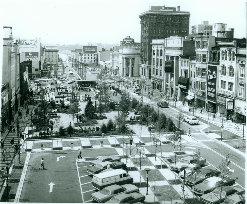
Figure 2-2. Penn Street, ca. early 1950s. Figure 2-3. Penn Square Rotary, ca. early 1950s.
After the addition of automobiles and buses to the mix in the early 1900s, Penn Street became highly congested. In 1934
a traffic circle was installed in the center of Penn Square to control traffic. Outlined at first with painted lines and later with
poles and chains, the circle was designed to slow converging traffic and permit safer left turns. However, maintaining it
proved a daunting job as motorists routinely crossed right through these impermanent barriers. The poles and chains
were removed and replaced several times over the next two decades until 1954, when concrete pillars were installed to
prevent motorists from driving through the circle. These remained in place until 1973 when construction began on the
Penn Square Pedestrian Mall.
City Decline and Urban Renewal (1950 - 1975)
Following WWII, cities throughout the country began to lose population as many of those who could afford to do so
moved to the suburbs. Business and industry also migrated out of the city to places where it was cheaper and easier
to operate, and which were more accessible to the automobile. Inner-city crime began to spike. Those who could not
afford to move out of the city burdened the government welfare and social programs that were put in place to provide
assistance. As a result the once prosperous downtowns, including Reading’s, fell into a state of disrepair.
Other national trends were also working against the city’s commercial core. Title One of the Housing Act of 1949 kick-
started the “urban renewal” program that would reshape American cities. The Act provided federal funding to cities to
cover the cost of acquiring areas of cities perceived to be “slums.” Those sites were then given to private developers to
construct new housing. City governments also used these federal funds to raze older buildings and entire city blocks to
construct public housing, highways, parking garages, and government buildings. Within Reading, large areas of dense
development in the downtown area were cleared and replaced with new structures or surface parking. An aerial photo
from 1971 shows those sections of the City that were razed at that time as well as those undergoing various stages of
redevelopment (see Figure 2-4). As documented in the City’s Comprehensive Plan (2000), these urban renewal projects
included:
• Walnut Street Project in the 1950s, which eliminated dense residential development in the block bounded by
Walnut, Poplar, Washington, and Reed Streets, and let to the development of the expansion of the Central YMCA,
the Walnut Street Pavilion of St. Joseph Hospital, and a major off-street parking garage.
• Court and Cherry Street Projects in the 1960’s, which involved the widening of Court and Cherry Streets to provide
service access to the rear of Penn Street properties. This project also resulted in the development of Washington
Towers, Plaza Madrid, the WEEU Building, the Chiarelli Plaza Parking Garage, the Fourth and Cherry Streets
Garage, off-street parking in the 600 block of Cherry Street, the South Penn Garage, Franklin Plaza, and the
Rhodes and Eisenhower residential high-rises.
• The Riverfront Urban Renewal Project, which started in 1968, led to redevelopment of the area surrounding Second
Barry Isett & Associates, Inc. • August 2011 • Page 16City of Reading • Downtown 2020 • Master Plan (DRAFT)
Figure 2-4. 1971 aerial photo of the downtown area. Red overlay denotes vacant lots.
Street, the Penn Street Bridge, and the Schuylkill River where there was a mix of industry, railroad, and high-
density residential uses in deteriorated condition. The redevelopment effort was further “assisted” in June 1972
by Hurricane Agnes, which brought the most serious flooding the City had ever experienced. The low-lying areas
along Riverfront Drive were destroyed, clearing the way for the Reading Area Community College campus and the
industrial development that now occupy these lands.
Penn Square Pedestrian Mall (1975 - 1990)
The Penn Square Pedestrian Mall was originally a component of yet another, much larger urban renewal plan. Sasaki
Associates’ Downtown East Urban Renewal Plan of 1971 proposed an enclosed shopping mall in downtown Reading
to compete with shopping malls being built in the suburbs. Penn Mall, which was to span the 600 to 800 blocks of
Penn Street, was to encompass a monolithic, cross-shaped nine-story building straddling Seventh and Penn Streets
that included both a parking garage and a train station. A large pedestrian space in Penn Square was planned as a
landscaped entrance to the enclosed downtown mall. After several delays, the Penn Mall project stalled for good due
in part to high interest rates and a slumping economy. When it became apparent that the economics of the downtown
shopping mall could not work the project developer withdrew the proposal.
Around the same time, state redevelopment funds became available and the Penn Square Pedestrian Mall was built
independent of its larger attraction. Most of the merchants on the square were in favor of the proposal at the time as it
was seen as a way to create a visible social center for the downtown and curb the number of young people cruising up
and down Penn Street in their cars.
Despite a proposal put forth by the Chamber of Commerce, which was designed by Elmer H. Adams & Associates and
included a simple landscaped boulevard with two lanes of traffic in each direction, the pedestrian mall was eventually
constructed in a modern design featuring fountains, angular steps, planting islands, and geometric paving patterns within
the 400 block of Penn Street. The 500 block of Penn Street was dedicated to surface parking. A narrow, one-way street
along the north edge of the pedestrian mall remained open to traffic, but shifting traffic to the north side made it difficult
for motorists to see what stores were located on the south side. It also took away on-street parking from the front of these
retail establishments and created large areas devoid of customers that were frequented by “vagrants.”
At that time, Reading was following a national trend as several cities throughout the country were closing their Main Streets
to automobile traffic in order to create shady pedestrian areas—an ambitious and hopeful effort to attract people
City of Reading. Comprehensive Plan 2000, 12.
Reading Eagle, January 17, 1990.
Barry Isett & Associates, Inc. • August 2011 • Page 17City of Reading • Downtown 2020 • Master Plan (DRAFT)
Figure 2-5. Penn Square Pedestrian Mall, early 1990s.
back to city centers who had fled to the suburbs following WWII. While this trend was met with mixed results in other
cities, Reading considered its pedestrian mall to be a failure.
BARTA Plan (1991-Present)
Realizing that the Penn Square Pedestrian Mall was not helping attract business back to the downtown core, the City
created the Penn Square Redesign Evaluation Committee in 1990 to explore the best options for re-opening the 500
block of Penn Square.
“As we enter a new decade, perhaps the time has come to reconsider the configuration of Penn
Square….To capitalize on the steady progress of downtown, we must consider the redesign of
Penn Square to accommodate the residents, merchants, pedestrians, and through vehicular traffic.”
(Mayor James Haggerty, quoted in the Reading Eagle, Jan 17, 1990).
The committee worked with Wallace Roberts Todd, Landscape Architects for a year to develop the most appropriate
design for Penn Square. When the City was unable to allocate funds for the approved concept, a new design for the
Square, to include a Downtown Transportation Center, was proposed by BARTA.
The City endorsed the new proposal and construction was completed in 1993. Funding for the plan, officially known as
the Penn Square Transportation and Development Project, was primarily provided by federal transportation dollars. The
design included eight pull-in parking areas for bus loading/unloading, 48 diagonal automobile parking spaces, a variable
Barry Isett & Associates, Inc. • August 2011 • Page 18City of Reading • Downtown 2020 • Master Plan (DRAFT)
Figure 2-6. Penn Square Transportation and Development Plan.
width median, geometric sidewalk paving patterns, paved
crosswalks, street trees, and raised planters.
By the time the street was reopened, however, the
big department stores and many of the smaller retail
establishments had already left. Bus traffic resulted
in drawing little new investment to the downtown core.
Today most of the bus parking spaces and oversized
shelters are underutilized as the focus of bus transit has
shifted to the BARTA Transportation Center, which was
built in 2002.
Figure 2-7. Existing phone kiosk, Penn Square. Figure 2-8. One of eight bus shelters located within Penn
Square.
Barry Isett & Associates, Inc. • August 2011 • Page 19City of Reading • Downtown 2020 • Master Plan (DRAFT)
CHAPTER THREE : ANALYZING THE PRESENT
It is not a coincidence that every downtown with a vibrant commercial or civic center is also pedestrian friendly. The more
pedestrian friendly a street, the more people will be inclined to get out of their cars, walk along it, patronize its stores and
businesses, talk and mingle with other people, and want to come back to do it again. In Suburban Nation: The Rise of
Sprawl and Decline of the American Dream, author Jeff Speck makes the following claim:
“Community cannot form in the absence of communal space, without places for people to get
together to talk. Just as it is difficult to imagine the concept of family independent of the home, it
is near-impossible to imagine community independent of the town square or the local pub….In the
absence of walkable public places—streets, squares, and parks, the public realm—people of diverse
ages, races, and beliefs are unlikely to meet and talk (p. 60).
The purpose of this analysis is to understand where existing streetscapes can be improved in order to effectively link the
most meaningful destinations, of which there are several. Some serve as important civic or community destinations to
the local/inner-city population, whereas others serve as major cultural attractions and destinations to out-of-town visitors
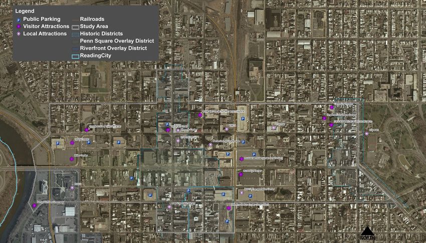
(see Figure 3-1). Some of course serve as both. The most notable are listed below, and those primarily supporting the
“tourism and hospitality” industry sector are noted with an asterisk:
• Abraham Lincoln Wyndham Hotel* • RACC
• BARTA Transportation Center • Schuylkill River Greenway*
• Berks County Courthouse • Sovereign Center*
• Central PA African American Museum* • Reading City Hall
• City Park • Reading Civic Theater*
• Doubletree Hotel (under construction)* • Reading Library
• Genesius Theater* • Reading Post Office
• Goggleworks* • Reading Station (under renovation)*
• Hispano Center • Sovereign Center for the Performing Arts*
• IMAX Theatre* • YMCA
• Miller Center*
Figure 3-1. Major destinations within the downtown core. Dark purple asterisks serve as major cultural attractions and
destinations to out-of-town visitors, whereas light purple asterisks serve as important civic and community destinations.
Barry Isett & Associates, Inc. • August 2011 • Page 21City of Reading • Downtown 2020 • Master Plan (DRAFT)
WALKABILITY CRITERIA
Speck (2009) also cites four pre-requisites that are needed for successful street life: mixed uses, safe streets, comfortable
streets, and interesting streets. By applying Speck’s methodology to gauge the pedestrian friendliness of streets within
Reading’s downtown, it becomes clear which streets are more pedestrian friendly than others. The following criteria were
used to rank the existing walkability, or pedestrian-friendliness, of all the streets within the study area. Particular focus
was given to those streets that serve as connectors between the major destinations identified above.
Mixed Uses
The more uses along a city block, the more reasons people have to walk along it. Streets with many uses (i.e. housing,
office/commercial space, retail shops, restaurants, schools, and parking or transit) provide greater conveniences to
pedestrians. For example, if a person who works in an office building located down the street from a bank, drug store,
and/or a grocery store, they are more likely to walk to those places during their lunch hour or on their way home in the
evening to make their purchases or run errands because it will take less time than driving to these separate destinations
elsewhere.
Perception of Safety/Sense of Enclosure
Feeling that a street is safe enough to walk along is perhaps more important that any actual statistics relating to crime or
physical injury when it comes to encouraging pedestrian activity. Perception of safety is most influenced by:
• The speed at which vehicles are travelling and the volume of traffic (the more cars and the faster the speed,
the less safe a pedestrian will feel).
• The presence of a physical buffer from the traffic (such as parked cars or a planting strip with street trees,
bollards, etc.).
• Two way streets. Typically drivers will travel faster on one-way streets than on two-way streets. Pedestrians
also may be unaware of which direction vehicles are travelling and accidently step out from the curb while
looking for cars in the wrong direction.
• Crosswalks. The presence of pedestrian crosswalks, crossing signals, and bump-outs makes pedestrians
feel safer because they know that they are given the right of way. Bump-outs decrease the distance that a
pedestrian must cross and increase safety.
• “Eyes on the street” is a difficult criterion to quantify, but it pertains to how much other activity is present either
on the street or within the buildings that align the street. The more people can see other people, the safer they
will feel. People feel less safe when buildings are vacant or closed, window shades are drawn, and windows
are dark.
Figure 3-2 (left). One way traffic traveling at high speed, no buffer, lack of enclosure, and no “eyes on the street” make
2nd Street an unfriendly pedestrian corridor. Figure 3-3 (right). The opposite is true along the 900 block of Washington
Street, where on-street parking, retail storefronts with residential apartments above, and a greater sense of enclosure
create a comfortable pedestrian corridor.
Barry Isett & Associates, Inc. • August 2011 • Page 22City of Reading • Downtown 2020 • Master Plan (DRAFT)
Figure 3-4 (left). Vacant lots and blank walls along 3rd Street create an unfriendly pedestrian environment. Figure 3-5
(right). Retail storefronts with large windows and a continuous building line along this segment of the 300 Block of Penn
Street create more visual interent for the pedestrian.
• Night lighting: If there is adequate lighting to illuminate sidewalks at night, people will feel safer; conversely, the
more dark a street, the less likely someone will be walk along it.
Comfortable Scale and Continuous Building Line
As explained by Speck, pedestrians feel most comfortable when they are enclosed by firm street edges. He suggests that
the ideal street space has a height-to width ratio of 1:1, and that any ratio greater than 1:6 fails to provide people with
an adequate sense of enclosure, creating an environment which people want to flee (2009, 8). Streets with a continuous
building line and street trees make pedestrians feel more comfortable than a street with vacant lots, surface parking lots,
and buildings with distant setbacks surrounded by open space.
Visual/Human Interest
Speck states that even if a walk is useful, safe, and comfortable, people will not choose to go on foot unless it is also at
least moderately entertaining. Nothing interests people more than other people. The more human activity and the greater
chance people will be able to see other people (even if it is through a store or restaurant window—glimpsing a “slice of
life”), the more interesting they will find it. Likewise, the more physically interesting, whether through architectural detail,
color, signage, street lights, street trees, benches, etc., the better. Conversely, the more repetitive a street (because of
blank walls, lack of entrances, lack of people), the less inclined people will be to walk along it, as no one willingly travels
from “sameness to sameness.” (2009, 9).
Figure 3-6 (left). The width of Penn Square provides little sense of enclosure. Figure 3-7 (right). The West Reading
streetscape is full of architectural detail, vibrant signs, and transparent windows that provide a “slice of life.”
Barry Isett & Associates, Inc. • August 2011 • Page 23City of Reading • Downtown 2020 • Master Plan (DRAFT)
RESULTS
See Figure 3-8 for the results of the walkability analysis. Streets that have a mix of uses and are perceived to be safe,
interesting, and comfortable were given a good walkability ranking (green). Streets that have few uses, are generally
perceived to be unsafe, lack a continuous building edge or sense of enclosure, and have low visual and human interest
were assigned a poor walkability ranking (red). Streets that had a mix of both good and bad qualities were given a
moderate ranking (yellow). A more detailed discussion of those streets determined to be “high priority pedestrian
connectors” can be found in the Conceptual Approach and Alternatives section of this study.
Figure 3-8. Results of the Walkability Analysis.
EXISTING CONDITIONS TRAFFIC ANALYSIS
The City of Reading downtown core intersects SR Business Routes 422 and 222, as well as Route 183 and Route 61; all
major north, south, east, and west routes. The roadway network has been changed over the years to efficiently move traffic
through the downtown core. A system of one-way streets, elimination of on-street parking, and widened intersections
effectively move traffic through and out of the City, although in some cases to the detriment of the pedestrian.
In support of this Master Plan, BIA conducted a traffic and pedestrian study to understand the pedestrian and vehicular
traffic volumes and turning movements at key intersections, the functionality of the existing street network, and also
future or anticipated traffic volume.
The study area for this traffic/pedestrian investigation consists of the following core intersections:
• Second Street (S.R. 2006) and Washington Street (S.R. 2010) - Signalized
• Second Street (S.R. 2006) and Penn Street - Signalized
• Second Street (S.R. 2006) and Franklin Street (S.R. 2008) - Unsignalized
• Fifth Street (S.R. 2005) and Penn Street – Signalized
Barry Isett & Associates, Inc. • August 2011 • Page 24City of Reading • Downtown 2020 • Master Plan (DRAFT)
Bus Service
The Berks Area Regional Transportation Authority
Second St.
(BARTA) serves the City of Reading with bus
Fourth St.
S.R. 2005
Sixth St.
Third St.
Fifth St.
service. The BARTA Transportation Center
Not to Scale
(BTC) opened at Cherry Street and 8th Street in S.R. 0183 Washington St. One-way
S.R. 0183 S.R. 2010
Route 1 & 20
March of 2002. This serves as a central transfer
Route 19
S.R. 0183
One-way
One-way
point for all 22 bus routes (except #6) and has a Route 18
passenger waiting area with an automated bus Penn St. Route 15
Route 12
Routes 14, 16 & 21
arrival and departure system, along with many
One-way
S.R. 2006
Cherry St.
One-way
other passenger amenities. BARTA operates
a fleet of 57 buses serving 21 routes, mostly Franklin St. One-way
originating at the BARTA Transportation Center. S.R. 2006 S.R. 2008
As mentioned above, future plans for BARTA
Second St.
Fourth St.
S.R. 2005
Third St.
Sixth St.
Fifth St.
include the restoration of the Franklin StreetS
tation.
As can be seen in Figure 3-9, many of the BARTA
buses travel through the study area intersections. Figure 3-9. Diagram showing BARTA bus routes through Penn
Penn Street is one of the main bus routes in the Square.
City. it is worth noting that transit and walking are
inextricably intertwined. It is not possible to have a large scale transit service in a non-walking city because people want
to arrive at and depart from transit as pedestrians.
Second Street (S.R. 2006)
Second Street is classified an “Other Principal Arterial Highway” and is also designated Business Route 422 through the
City of Reading. Second Street (S.R. 2006) is a stateroad. It is a one-way street southbound and provides two through
lanes. The posted speed limit is 25 MPH within the study area. Second Street (S.R. 2006) carries an Average Daily
Traffic (ADT) volume of approximately 9,000 vehicles.
The complex intersection of Second Street (S.R. 2006) and Washington Street (S.R. 2010) is signalized with pre-timed
settings for vehicular movements and actuation for pedestrian movements. This intersection is coordinated with adjacent
intersections and is part of the CBD closed loop system network. Washington Street (S.R. 2010) has dual left-turn lanes
westbound and dual right-turn lanes eastbound. Sidewalks with pedestrian curb ramps are provided at all four corners
of the intersection along with crosswalks and pedestrian refuge islands on Washington Street (S.R. 2010). Pedestrian
signal indications with count-down timers are provided for all four crossings.
Figure 3-10. Panorama of the intersection at Washington and Second Streets. Wide crossing distances, high traffic
volume and speed, lack of a buffer, “eyes on the street”, and little visual interest combine to create the perception of an
unsafe and uninviting pedestrian environment.
Barry Isett & Associates, Inc. • August 2011 • Page 25City of Reading • Downtown 2020 • Master Plan (DRAFT)
Figure 3-11. Intersection of Penn and Second Streets, Figure 3-12. Intersection of Penn and Second Streets,
looking east. looking south.
The intersection of Second Street (S.R. 2006) and Penn Street is signalized with pre-timed settings for vehicular
and pedestrian movements. This intersection is coordinated with adjacent intersections via spread spectrum radio
communication. Dual right-turn lanes are provided for
southbound Second Street (S.R. 2006) as well as a left-
turn lane. A left-turn lane is provided for westbound Penn
Street and a channelized right-turn lane is provided for the
eastbound approach. There are pedestrian refuge islands
on Second Street (S.R. 2006). There are no pedestrian
signal indications at this intersection. Crosswalks and
pedestrian curb ramps are provided at three of the four
crossings (none for the west leg of the intersection). No
pedestrian crossing signs are posted at the west leg of the
intersection.
The intersection of Second Street (S.R. 2006) and Franklin
Street (S.R. 2006) is unsignalized. Stop signs are posted
for the eastbound approach of Franklin Street and the
northbound approach of Second Street. Figure 3-13. Intersection of Franklin and Second Streets,
looking north.
Fifth Street (S.R. 2005)
Fifth Street is classified an “Other Principal Arterial
Highway” and is designated Business Route 222 through
the City of Reading. Fifth Street (S.R. 2005) is a state
road. It is a two-way street and provides two through
lanes. The posted speed limit is 25 MPH within the study
area. Fifth Street (S.R. 2005) carries an ADT volume of
approximately 9,400 vehicles.
Penn Street
Figure 3-14. Fifth Street looking north from Penn Square.
Penn Street is a local roadway within the City of Reading.
It is a two-way street and provides one through lane in each
direction. The posted speed limit is 25 MPH within the study area. The intersection of Fifth Street (S.R. 2005) and Penn
Street is signalized with pre-timed settings for vehicular and pedestrian movements. This intersection is coordinated with
adjacent intersections via spread spectrum radio communication. Left-turn lanes are provided for the eastbound and
Barry Isett & Associates, Inc. • August 2011 • Page 26City of Reading • Downtown 2020 • Master Plan (DRAFT)
Figure 3-15. Penn Street, looking west. Figure 3-16. Penn Street, looking east.
westbound approaches of Penn Street and are delineated with a concrete median. There are pedestrian signal indications
(walk/don’t walk indications) at this intersection, as well as a pre-timed exclusive pedestrian phase. Crosswalks and
pedestrian curb ramps are provided at all four crossings. Bus pull-outs are also provided along Penn Street. Existing
Traffic Signal Permit Plans for this and all other signalized study intersections are located in Appendix A.
Traffic Counts
Barry Isett & Associates (BIA) performed weekday peak period (7 – 9 AM and 4 – 6 PM) manual turning movement traffic
counts and pedestrian counts at each of the above-mentioned intersections on the 16th and 17th of March 2010. The
counts are tabulated and summarized in Appendix B (Figure 3 illustrates the AM Peak Hour traffic volumes and Figure 4
illustrates the PM Peak Hour traffic volumes).
Capacity analyses were conducted at each intersection within the study area to determine if there are congested
intersections. SYNCHRO 7 software was utilized to analyze the capacity and level-of-service of each intersection within
the study area under each of the studied conditions.
Level-of-Service (LOS)
According to the Highway Capacity Manual (2000 edition), level of service is defined as a qualitative measure describing
operational conditions within a traffic stream, based on service measures, such as speed and travel time, freedom to
maneuver, traffic interruptions, comfort, and convenience. Six LOS are defined for each type of facility that has analysis
procedures available. Letters designate each level, ranging from A to F, with LOS A representing the best operating
conditions and LOS F the worst. Each level of service represents a range of operating conditions and the driver’s
perception of those conditions.
For signalized intersections, the average control delay per vehicle is estimated for each lane group and aggregated for
each approach and for the intersection as a whole. LOS is directly related to the control delay value. The criteria are
listed in Table 1 below:
Table 1 – Level of Service Criteria for
Signalized Intersections
Level of Service Control Delay per Vehicle (sec/veh)
A < 10
B > 10 – 20
C > 20 – 35
D > 35 – 55
E > 55 – 80
F > 80
Barry Isett & Associates, Inc. • August 2011 • Page 27City of Reading • Downtown 2020 • Master Plan (DRAFT)
Level of Service for a Two-way Stop Control (TWSC) intersection is determined by the computed or measured control
delay and is defined for each minor movement. LOS is not defined for the intersection as a whole. The criteria are listed
in Table 2 below:
Table 2 - Level of Service Criteria for
Two-Way Stopped-Controlled Intersections
Level of Service Average Control Delay (sec/veh)
A 0 – 10
B > 10 – 15
C > 15 – 25
D > 25 – 35
E > 35 – 50
F > 50
Figure 3-17 illustrates the Levels of Service for existing AM Peak Hour conditions and Figure 3-18 illustrates the Levels
of Service for existing PM Peak Hour conditions. Refer to Appendix C for a comprehensive level of service analysis by
approach under each of the studied conditions, and for queues by approach for each of the studies conditions.
In general, the Penn Street traffic analyzed for this study functions at a LOS of D or above during peak AM and PM traffic
flow. The only exception to this is westbound traffic from Penn Street to the Penn Street Bridge, which has an LOS of F
during the peak afternoon traffic period.
East and southbound traffic at the Second and Washington Street intersection, which has been expressed as a concern
by many, functions at a LOS of C and B respectively during peak morning and afternoon traffic. This is also the case for
southbound Washington Street traffic and eastbound turns onto Franklin Street. However, traffic turning from Second
Street onto the Penn Street Bridge in the peak afternoon traffic (and vice versa) has a LOS of E and F respectively.
Second St.
Fourth St.
S.R. 2005
Third St.
Sixth St.
Fifth St.
Not to Scale
D
C
C
S.R. 0183 Washington St. One-way
S.R. 0183 S.R. 2010
D
S.R. 0183
One-way
D C C C
B
C
C Penn St. B C
F C D
F C C
S.R. 2006
One-way
One-way
A C
B B C C
One-way
Franklin St.
F S.R. 2006 S.R. 2008
B C A
E A C B
Second St.
Fourth St.
S.R. 2005
Third St.
Sixth St.
Fifth St.
2010 Existing Levels of Service
AM Peak Hour
Figure 3-17. 2010 Existing Levels of Service (AM Peak Hour).
Barry Isett & Associates, Inc. • August 2011 • Page 28You can also read