PROVIDENCE 2020 may 2006 - Greater City Providence
←
→
Page content transcription
If your browser does not render page correctly, please read the page content below
PROVIDENCE 2020may 2006

                         PROVIDENCE 2020    i
         ZHA | Barbara Sokoloff Associates | VHB
Mayor of Providence
                     David N. Cicilline

I hope you find this document as exciting as I do. In the pages that follow you will read
about and see images of what our city may become. It is a future built on the best
aspects of our past – reconnecting the city to the water, re-linking neighborhoods to
the downtown, preserving our great stock or architecture, ensuring that transit serves a
critical role in the life of the city, and creating superior public spaces.

The goal of Providence 2020 is to provide a vision for coordinating and integrating
the array of development opportunities in Providence. And given the unprecedented
interest in our city and the unprecedented opportunities that will open up in the years
ahead, a document of this type is critically important at this time.

Providence 2020 details the principles that will guide us in the years ahead. The
document spells out the priorities we will seek to achieve as we build and revitalize
our city. It helps define where development should take place, what the shape and
character of development should be and what goals it should serve. It offers guidance
for ways in which development can complement and promote public use and
enjoyment of the city from streetscapes, to squares, to parks, to the waterfront.

This is not a detailed blueprint of what Providence will look like in the future. That will
unfold over time as projects are proposed and considered. But for those who want to
make such proposals, this document provides the necessary guide.

In the end, a vision of the future is only as good as the will to make it happen. I urge
those of you inspired by the vision spelled out here, to become actively engaged in
helping to realize the full range of potential that lies before us.

Those who built Providence had ambition, but they did more than just dream. We are
deeply indebted to those builders of our great city who turned thought into action and
vision into reality. This document is dedicated to the continuation of that tradition well
into the 21st Century.

                                                          David N. Cicilline

         City of Providence, Rhode Island 02903
       Phone (401) 421-7740 Fax (401) 274-8240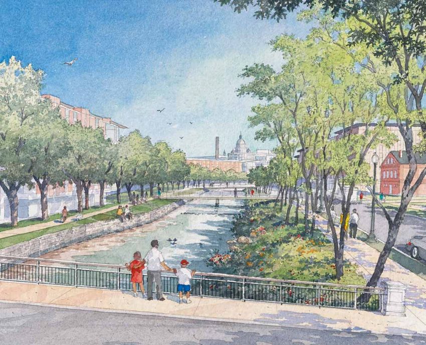
iV PROVIDENCE 2020
The City of Providence would like
                                                             to thank the many residents and
                                                             other interested participants who
                                                             contributed to Providence 2020.

E X E C UT I VE SUMMARY . . . . . . . . . . . . 1            TABLE OF
                                                             CONTENTS
P R IN C I P L ES . . . . . . . . . . . . . . . . . . . 13

C IV IC R EAL M . . . . . . . . . . . . . . . . . . 17

D E V E L OP MENT O P P O RTUNITIES . . . 27

D IS T RI C T C ONCEP T S . . . . . . . . . . . . 39

IM PL EMENTAT I ON . . . . . . . . . . . . . . 61

                                                                    PROVIDENCE 2020          v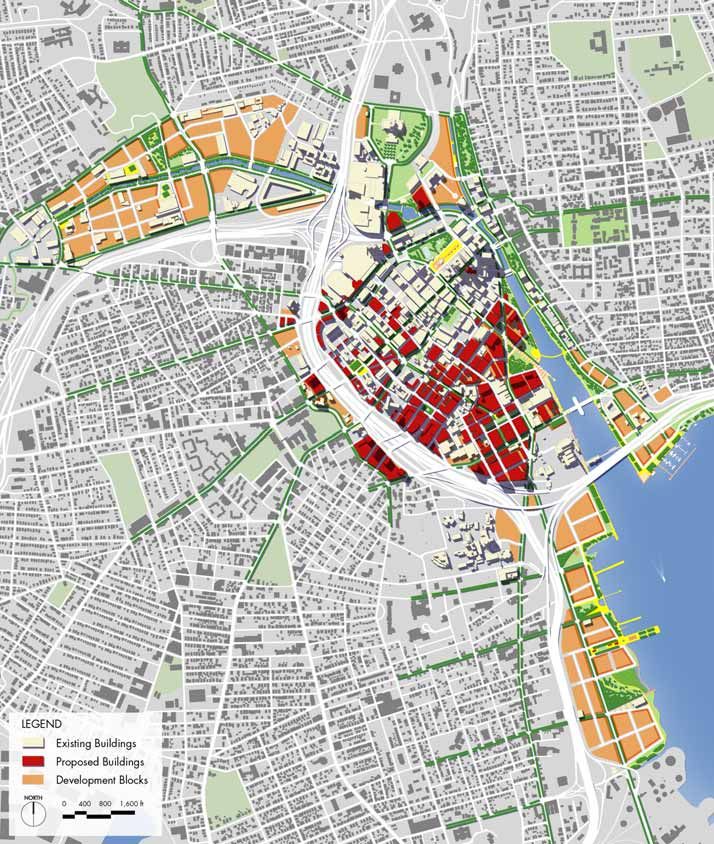
vI PROVIDENCE 2020
V IS IO N EXECUTIVE
In the future, Providence will be a waterfront city, where the water, continuous
parks, and transit link the Valley to the Bay. Along this spine, downtown will
SUMMARY
be a premier environment for a great variety of economic activities, with
innovative industries, commerce, higher education and medical services,
research, retail, culture, and housing for a diverse population. In this century,
water may reclaim a role as local transportation, but its primary force will be
recreation, amenity, and natural environment.
Providence is a city of great variety, with an historical pattern where
residential neighborhoods on the hills overlooked waterfront industry and
commerce, (Figures 1-3). As rails and highways pierced the city, each district
developed its own personality, one complementing the other. Looking to the
future, the character of each district should be celebrated by acknowledging
the different strengths so that they continue to complement one another. This
approach will build a city with a variety of choices for living, many different
destinations for visiting, and investment decisions based on physical and
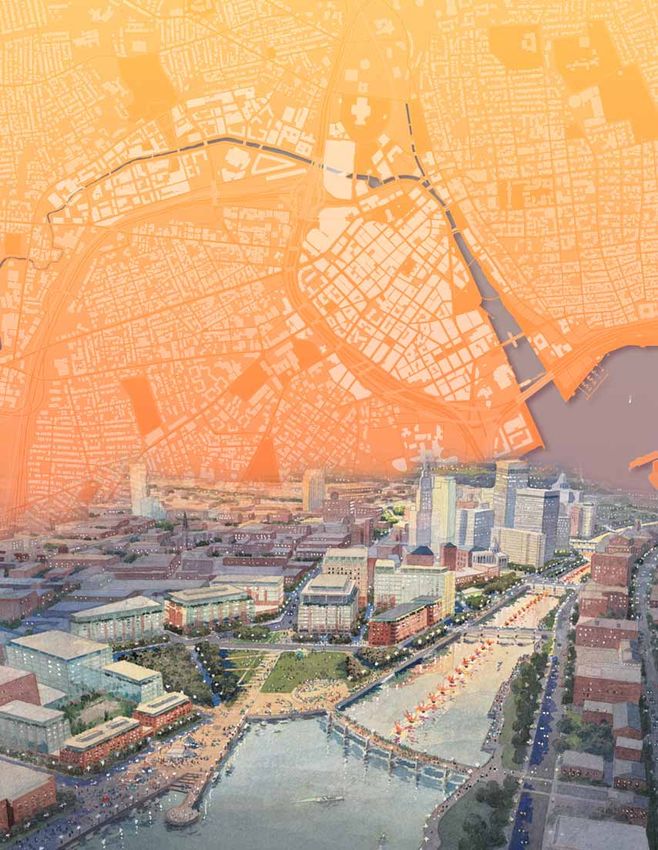
economic competitive advantages, (Figure 4).
PROVIDENCE 2020 1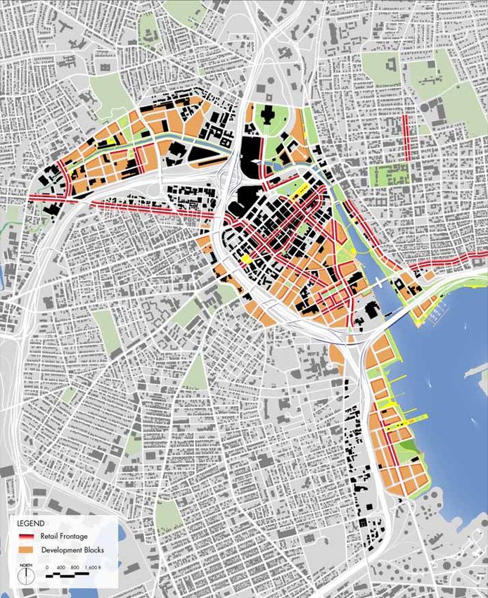
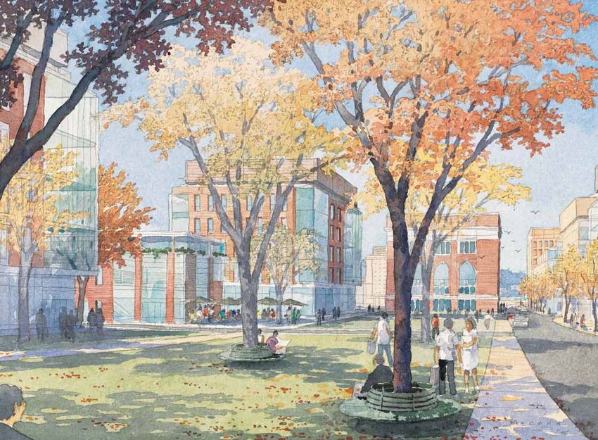
< FIGURE 1 Study Area Downtown
                                                           Providence commands a position on
                                                           the river valleys and the bayfront.

                      ^ FIGURE 2 The residential neighborhoods
                        occupy the high ground surrounding the
                        greater downtown.

                      < FIGURE 3 Topography The study area
                        focuses on the low lying land where
                        industrial and commercial activities have
                        traditionally been located. In the future,
                        the mix of uses in this area will become
                        more diverse.

2   PROVIDENCE 2020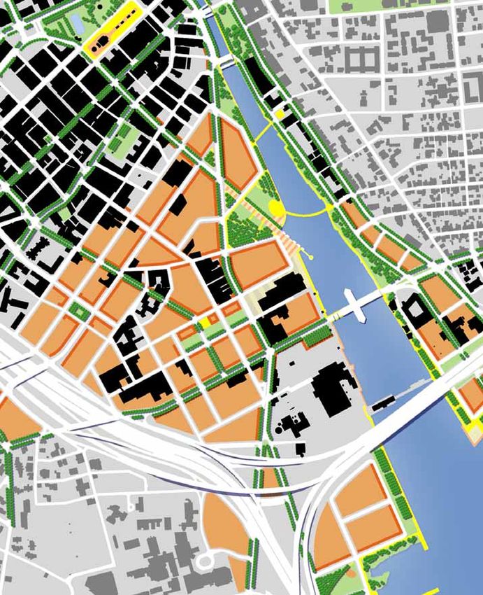
^ FIGURE 4 Vision Plan A continuous spine of
  waterfront, public access, and transit will connect
  the distinct districts of Providence. Within each
  district, new civic spaces and the introduction of
  new streets in the former industrial districts offer
  stunning potential for Providence’s future.

                                                         PROVIDENCE 2020   3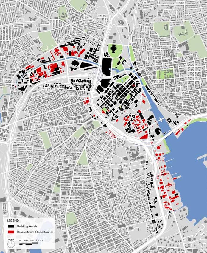
The continuous waterfront greenway will weave through            A continuous transit spine will connect Eagle Square to
the different districts that make up downtown Providence:        Thurbers Avenue, along the length of the waterfront. In the
Promenade, Capital Center, Downcity, Jewelry District,           short term, this may be a rubber-wheel trolley, and over
and Narragansett Bay. Part of the city’s distinct charm is       time will become bus rapid transit and if driven by demand,
the variety of places in the river valleys and the bay and up    light rail transit. A series of stations spaced about one-half
on the surrounding hills. Different architecture, uses, and      mile apart will serve each district with express service. At a
tradition make each area stand on its own merits. The future     few key locations, intermodal centers could interface with
will depend on the strength of the linear connections along      regional RIPTA bus service and provide structured parking.
the waterfront and the links to the neighborhoods so that        The existing trolley system serves as a feeder system that
every resident feels ownership of downtown. Over time, the       complements the transit spine. Over time, new routes may
downtown areas will become neighborhoods in their own            be needed to serve downtown neighborhoods.
right, each with it’s own mix of uses.

Downtown will offer distinct competitive advantages to
other locations in the region by offering urban amenities        SUMMA RY OF DEVELOPMEN T
that cannot be found elsewhere. People who choose to             PRINCIPLES
live downtown in historic lofts or new apartments and            The Providence 2020 plan sets forth a flexible framework
rowhouses will be able to walk to work, shops, or the            for development integrating and anticipating the actions of
theater. Events like Waterfire and outdoor concerts on the       the public sector, the private sector, the institutions, and the
waterfront parks will draw people downtown to experience         many non-profit organizations. Seven principles form the
the ambiance of the city in the evening. Every downtown          foundation for every recommendation in the plan. Within this
district will have a waterfront park that ties that local area   framework, a great variety of decisions can be made over
into the regional open space network, making it easy to          time to create the richly textured city, while still ensuring a
jog or stroll at lunchtime or before or after work. Activities   shared vision of the overall outcome. The seven principles
on the water will range from sailing on the bay to fishing in    are summarized as follows:
the upper reaches of the rivers. The rivers and the bay can
                                                                 1. CREATE distinctive parks that establish the city’s
become gateways for environmental education programs in
                                                                    identity, link districts, and are integral to surrounding
the schools.
                                                                    development
Downtown’s unique advantage is the ability to foster face
                                                                 2. LINK the Valley to the Bay with transit and a
to face interaction. Walkable streets, for which Providence
                                                                    continuous transit spine
is already well known, will extend into the former industrial
districts. With the relocation of Interstate 195 to the south,   3. CONNECT each neighborhood to downtown
one will be able to walk easily from a center point around          and the waterfront
Friendship Street to the Providence Place Mall to the north
or to the Point Street corridor to the south, a ten-minute       4. CREATE a network of pedestrian friendly streets
walk in either direction. To reach the neighborhoods,
beautiful tree-lined corridors will lead up the hills, making    5. CELEBRATE great architecture
the ten-to twenty-minute walk seem shorter (Figures 5 & 6).
                                                                 6. POSITION each district according to its unique
                                                                    assets to promote diverse mixed-use environments

                                                                 7. DEVELOP shared parking in strategic locations

4      PROVIDENCE 2020
inute walk
20 m
e walk
minut
10
RISD
Brown
URI University
Providence
< ^ FIGURE 5 Institutions Brown University, Rhode
Johnson
& Wales Island School of Design, Johnson & Wales
University, and the University of Rhode Island
Providence campus are all within a ten minute
walk of downtown.
Rhode Island
Hospital
< ^ FIGURE 6 Neighborhoods The
surrounding neighborhoods have
traditionally been residential
with small commercial areas.
The restaurants on Federal Hill,
however, are regional destinations.
1 For the purposes of this report, Downcity includes all of the area bounded by the
Providence River, existing I-195, and Interstate 95. The Narragansett Bayfront includes all
the area outboard of Interstate 95 and the future I-195 alignment.
PROVIDENCE 2020 5C O N T E XT
Water defines the City of Providence. Lofts, warehouses, With momentum and new leadership, Providence has set
and commercial buildings crowd the banks of the a course for positive change that builds on its strengths
Woonasquatucket River and the Providence River. A while envisioning a future that is innovative and exciting. As
century ago, the working waterfront shifted from these one part of that effort, this master plan presents a coherent
rivers to the upper reach of Narragansett Bay, which now vision for the entire 1,200-acre area defined as Providence
presents a dramatic opportunity for the future. Most of the 2020. The many previous plans are reconciled and updated
residential neighborhoods sit high on the hills overlooking to fit within this unifying vision so that priorities can be
this broad sweeping valley that arcs from Eagle Square on established for implementation initiatives and public
the northwest to Sassafras Point at Thurbers Avenue on investment. The strategies for implementation will reinforce
the southeast. both the overall vision and the distinctive character of each
place. Many entities and individuals have a stake in the
Providence has dramatically transformed its image to future of downtown. The success of this plan will require
recognize its many valuable assets. Besides the thread of strong partnerships and the contributions of many entities,
water that connects all parts of downtown, many of the working toward a shared future.
city’s narrow streets find their way down to the water’s
edge. Wonderful examples of 19th century commercial
architecture line the streets of downtown. In other areas,
brick warehouses and lofts create a different character in PROJECT NEED
the former industrial districts (Figures 7-12). In recent years, the city has experienced a barrage of
development proposals for key areas of the downtown.
The city has long been home to great institutions, such New proposals often exceed existing height limitations,
as Brown University, the Rhode Island School of Design, raising the question of where to direct height and density.
Johnson & Wales University, University of Rhode Island Meanwhile, other areas languish. Many plans have been
Providence, and the Community College of Rhode Island. developed over the years, but each one focuses on a small
All of these institutions have facilities in the downtown area, territory creating a patchwork without any connections
bringing creativity, knowledge, youth, and culture to the physically or economically (Figures 13 & 14). Questions
environment. Medical facilities and research form a core have arisen about the relative strengths of the housing and
component of the city’s economy, led by the Rhode Island office markets. In a city where downtown used to be the
Hospital and the Women and Infants Hospital. job center and the primary tax base, concern exists about
the opportunity costs of ongoing residential development
Downtown Providence celebrates the traditional role of
and institutional expansion. With so many distinct districts
downtown as the center of culture with a broad range
downtown, to which one should prospective investors be
of performing and visual arts. Originally conceived as a
directed and where should public investment be targeted?
public art installation, Waterfire is now a beloved civic
How does the new land created by the demolition of
gathering, renowned around the country as a unique part
Interstate 195 fit into the overall picture, and how does the
of Providence’s identity. People descend on downtown for
location of the new highway alignment affect surrounding
theater, music, art galleries, museums, or just to enjoy the
uses? (Figures 15 & 16)
many public art pieces found in the city’s civic spaces.
Rather than operate in a reactive mode, the city initiated
this planning process to celebrate each district while
looking at how all the pieces fit together. The city’s goal is
to direct and shape private investment through consistent
policies and targeted capital improvements. A fundamental
underpinning of the current planning process has been to
include public outreach so that this input can help shape
the vision and the recommendations.
6 PROVIDENCE 2020^ FIGURE 10 Civic buildings,
such as City Hall, anchor
the Downcity.
^ FIGURE 7 The restoration
of the Providence River
began the transformation < FIGURE 11 Many of the
of the city’s image. industrial buildings in the
Promenade District are
underutilized or vacant.
^ FIGURE 8 At the Narragansett
Bayfront, access to the water is
almost impossible.
^ FIGURE 12 The center of the Jewelry
District has one-story buildings that
do not take full advantage of this
valuable location in the city.
^ FIGURE 9 Downcity is eminently
walkable with its narrow streets and
historic façades.
PROVIDENCE 2020 7< FIGURE 13 Collage of Previous Plans
Previous plans dealt with only pieces
of the greater downtown, without
considering the connections or the
combined potential.
^
FIGURE 14 The highways slice through
the city, separating neighborhoods from
downtown and isolating districts.
^ FIGURE 15 Existing I-195 alignment ^ FIGURE 16 Future I-195 condition currently under construction:
Interstate 195 is being relocated to the south, opening up an
opportunity to reconnect downtown districts.
8 PROVIDENCE 2020< FIGURE 17
Before the highways,
downtown Providence
was an integrated,
pedestrian-oriented
urban environment.
^ FIGURE 19 Interstate 195 has
resulted in an isolated urban
landscape.
^ FIGURE 18 In the 1950’s, Interstate 195 cut
the Jewelry District from the downtown.
PROVIDENCE 2020 9PR O C E S S
In the late fall of 2004, the City of Providence engaged Like all great cities of the world, Providence has been
the Sasaki team to prepare the plan, including ZHA for shaped by the actions of many different players from
economics, Barbara Sokoloff for community planning, and the public, private, institutional, and non-profit sectors.
VHB for infrastructure. In discussions with the project team In today’s competitive economy, these actions must be
in January 2005, stakeholders identified issues, goals, and efficiently directed toward building a shared vision. The
ideas during one-on-one and small group interviews with city must be perceived as a good place to do business,
the project team. Interest groups included neighborhood promoting confidence for investment and streamlining
representatives, arts and cultural organizations, real estate approvals. Expectations should be clear regarding the
developers, large employers, economic development, form and type of development that will be acceptable, with
environmental, institutions, and State and City staff. The an emphasis on the highest quality architecture that will
Mayor and City Council were also consulted for their ideas endure over time to complement this historic city. Public
and priority issues. Many of the recommendations from the involvement can leverage private investment, achieving
recent charrette (spring 2005) led by Duany Plater-Zyberk fiscal goals for a stronger tax base as well as civic goals for
& Company were integrated into the plan. job creation, affordable housing, ease of transit, and open
space for citizens.
After synthesizing a range of issues and developing design
studies and alternatives for the study area, the project team
met with stakeholders and held two consecutive open Role s a nd Re sponsibilitie s
house/public meetings in early May 2005. The comments To achieve the vision laid out in the Providence 2020
received in these meetings shaped the draft plan, which plan, leadership will come from the city, the Rhode
was reviewed and discussed with stakeholders and the Island Economic Development Corporation (RIEDC), and
public during another series of public meetings held in mid- the Rhode Island Public Transit Authority (RIPTA). The
June 2005. recently instituted Downtown Improvement District will
play a growing role in maintaining the quality environment
that encourages downtown visitation and investment.
A new entity, the Providence Development Corporation,
S U M M A RY O F I MP L EM EN TAT I ON is recommended to provide the geographic focus and
S TR AT E G Y ongoing commitment to downtown interests. Under this
The implementation strategy addresses phasing, costs model, the Providence Development Corporation will
for first phase projects, and roles and responsibilities of become the coordinating entity that brings together the
the different entities involved. Unlike previous plans, the shared interests of the city, the state, the private sector, and
Providence 2020 plan has looked at the greater downtown the institutional sector.
area that connects the Valley to the Bay. This larger study
area encompasses several distinct districts and sets In Providence, the universities and hospitals are committed
the goal of distinguishing each district while prioritizing long-term stakeholders who benefit directly from the
public investment across this broader area (Figure 8). In quality of the city as a place to work and live (Figure 9). The
this way, the public and the private sectors can target institutions provide an economic engine for the City, serving
development to the appropriate district within the context as some of the largest employers and creating the potential
of a schedule for improvements over a 15-year period. for spin-off research and production. Working together
Phasing plans allow the involved stakeholders to focus their as partners, the city and the institutions will be able to
efforts, and direct capital budgets and fundraising for the increase retention of recent graduates with the prospect
immediate projects. The strength of the plan, however, is of good jobs, opportunities for start-up businesses, and
its flexibility to accommodate opportunity-driven projects an attractive and interesting place to live. Within the
and unforeseen situations within an overall development new economy, innovation technologies come out of the
framework. research culture of universities and hospitals, but over time,
successful businesses grow into production and create the
need for jobs at all levels. Community colleges can play a
lead role in training the workforce for these jobs.
10 PROVIDENCE 2020The non-profit sector in Providence plays a significant role Longer term projects (2016 to 2020) will shift the focus
in creating the quality of life in the city today and ensuring to the Narragansett Bayfront, while continuing to provide
its improvement in the future. These entities are committed critical connections with in the other districts. The East
to a range of issues including the visual and performing and West Service Roads that cut across the top of the hill
arts, environment, open space, and affordable housing, from the Jewelry District to Downcity and from Federal Hill
among others. In many cases, these organizations are to South Providence will be targeted for improvements to
invaluable in addressing civic issues and extending the create gateway streets. Investments in bridges across the
capacity of the public sector. By committing professional Woonasquatucket River will facilitate movement across the
resources, seeking third-party funding, and advocating for Promenade District.
quality of life issues, the non-profit sector is vital to shaping
the city and making it livable for all residents. Like capital projects, policies also shape city form. Because
changes to policy are necessary to achieve the Providence
2020 vision, these efforts should be a high priority in the
Ph a s in g o f P ro ject s an d P o licie s next year or two. Streamlining the approvals process
The designation of priority projects for the next five years centers around updating the Zoning Ordinance, a process
(2006 to 2010) is driven in part by the schedule of the that is already underway. The city’s approval process
relocation of Interstate 195, which is expected to be open should be closely coordinated with the State’s regulatory
for traffic in both directions in 2009. Before that time, some review, which will be largely shaped by the new Providence
work can be done to enhance each district. A primary Special Area Management Plan. Both of these policies
focus should be on Downcity streetscape improvements must come to terms with the shared goals for economic
that complement private sector investment and enhance development and quality urban environments and the
connections to the neighborhoods. Another near-term incentives and regulations that are used to achieve these
project that would make a significant impact would be goals.
improvements to the Woonasquatucket River edge and
adjacent streets, which will complement ongoing private Development incentives are a powerful tool used by both
sector investment in the area. In the Jewelry District, the City and the RIEDC. This close partnership should
streets and park improvements outside the right-of-way continue and would be enhanced by a new entity such
would help spur short-term investment in this key area. The as the Providence Development Corporation as a central
Narragansett Bayfront represents an important area for the clearinghouse. The Providence 2020 plan underscores
long term growth of the city; in the short-term efforts here the importance of tax increment financing to acquire key
should be on land assembly and remediation. land parcels and realize capital improvements, while also
providing a strategy and criteria for land acquisition.
Once the Interstate 195 relocation is complete, a major
focus of the second phase (2011 to 2015) will be to repair Downtown Providence is graced by the Woonasquatucket
the fabric of the city with new streets and parks that River, Providence River, and Narragansett Bayfront. A
define development parcels. Enhancing connections will consortium of city, state, and non-profit entities are working
continue to be a major focus, with efforts to implement together to ensure the protection, conservation and
a bus rapid transit between the Valley and the Bay, the recreational use of coastal and riverfront resources, which
rebuilding of Westminster Street and Cathedral Square, and will be vital to the success of this waterfront city.
improvements along the length of Dean Street connecting
South Providence, the West End, and Federal Hill across
the Promenade to Elmhurst. Ongoing investment in
streetscape and parks in the Promenade will create a sense
of place to encourage business investment in this area.
PROVIDENCE 2020 1112 PROVIDENCE 2020
The design and development principles are part of a framework that will           PRINCIPLES
guide public improvements and future development over the next several
decades. The overall approach is to allow for flexibility to respond to
unforeseen changes in the market and technology over time. At the same
time, overarching principles for urban form establish a level of predictability
necessary to inspire investment. More specific guidelines for individual
development projects are embodied in the city’s new zoning code, which
among other things, establishes performance criteria for the way a building
engages the civic realm of the city.

                                                                                     PROVIDENCE 2020   13
PR I N C IP L E O N E PRINCIPLE TW O
C R E AT E d is t in ct ive p arks t h at LINK the Va lle y to the B a y wi th
e st ab l is h t h e cit y’s id en t it y, link a c ontinuous tra nsit spine
di s trict s , an d are in t eg ral t o A convenient downtown transit system provides a realistic
surro u n d in g d evelo p m en t alternative to automobile use. Such a system can help
Great parks establish the identity of great cities. Central Park connect downtown residents to jobs and services, reducing
in New York, Grant Park in Chicago, the Common in Boston, parking demand and congestion especially at peak hours. In
and Rittenhouse Square in Philadelphia are known widely. the evening, transit can connect various cultural events and
In smaller cities, parks can also establish identity, such as dining. No matter what mode employees use to commute, a
Savannah’s public squares and the creation of new waterfront transit system facilitates business interaction throughout the
parks in Charleston, South Carolina. day. As infrastructure, a transit line will induce development
along its route and especially at key stations, setting the stage
These parks are not developed in isolation; They are for transit oriented development (TOD).
instead complements to the surrounding city, with urban
developments that look out over the parks. The development In downtown Providence, a new transit spine will parallel
draws real estate value from the parks because of the the waterfront greenway, connecting the series of districts
views and the physical amenity for residents and workers. and allowing workers, visitors, and residents to travel easily
At the same time, these same people become the primary back and forth along the valley and bayfront. Regularly
champions of park safety, maintenance, and ongoing spaced stops will allow convenient pedestrian access to this
investment. Urban parks isolated from the watchful eyes of service. At strategic locations, intermodal stations will provide
surrounding uses are diminished and become unsafe for many connections to the regional RIPTA service, to the downtown
segments of the population. trolley service, and to parking. By interrelating the transit
spine to the spokes that radiate out into the neighborhoods,
The greater downtown of Providence is a sweeping arc that the surrounding residents will have improved access into
includes all the commercial and industrial districts from the downtown and its many destinations.
Promenade to the Narragansett Bayfront. Highways and rivers
separate the districts into a series of quite distinct places, yet
every downtown district faces onto either a river or the bay.
In the future, Providence will be known for the length and
diversity of its waterfront trails. This continuous greenway
PRINCIPLE THREE
will pass by formal urban waterfronts, intimate natural habitat
areas, and open sweeping viewing areas, connecting to
CONNECT e a c h ne ighborho o d to
regional trail systems on either end.
dow ntown a nd the wa te rf ron t
The relationship of neighborhoods to downtown should
be based on the demand for special and complementary
uses, attractive physical connections, distinctive views,
and access to the water. The downtown needs to maintain
its preeminence as the center of culture, government, and
commerce to attract visits from residents. Based on historical
access to the water, a series of avenues lead down from
the hills into downtown. These avenues should be active,
landscaped, pedestrian-friendly streets that serve as gateways
to downtown. Trolley service on key corridors will reinforce
the neighborhood-downtown connections. Because water
plays a role in every downtown district, surrounding residents
should feel connected to a waterfront landing close to their
neighborhood. Each of these waterfront landings could feature
distinct characteristics, reflecting the local history of the
district and the nearby neighborhoods.
14 PROVIDENCE 2020PR IN C IPL E F OUR PRINCIPLE SIX
C R E AT E a n et wo rk o f p ed es t ria n POSITION e a c h distric t
frien d l y s t reet s a c c ording to its unique a ss ets
Identifying a hierarchy of streets establishes priorities for to promote dive rse mixe d- u s e
investment, and also orients visitors to corridors that connect e nvironme nts
one district to another. Providence is known for its pedestrian- Providence will become an interesting and multi-faceted city
friendly streets that calm traffic and allow people to stroll in through the enhancement of the unique attributes of each
small groups along historic building façades and under shady downtown district: Promenade, Capital Center, Downcity,
trees (Figure 13). While this character is prevalent in Downcity, Jewelry District, and Narragansett Bayfront. These distinct
the industrialized tracts on either side need the positive places developed according to their own geography and
identity that a great street offers. A network of streets will have always offered different economic advantages. While
create more developable blocks while ensuring permeability to technology and economies have changed, the character and
the waterfront along public streets. relative position of each district suggest that development
should be directed toward each district’s competitive
advantage. Although the form, timing, and ultimate character
will vary, each district can become a vital mixed-use place
offering jobs in close proximity to housing, service retail, and
PR IN C IPL E F I VE environmental and cultural amenities.
C E L E BR ATE g reat architecture
The quality of the architecture defines the unique character of
a place and imbues it with meaning. At this juncture in time,
Providence has the opportunity to strengthen its core identity PRINCIPLE SEVEN
through the preservation of historic building stock while
advancing its future identity with significant new buildings. DEVELOP sha re d pa rk ing
in stra te gic loc a tions
The historic building stock, whether finely detailed commercial
The economics of parking make development difficult in
buildings, wood frame residences, or massive brick lofts, is
Providence, especially where height and density are sensitive
irreplaceable in the quality of the architecture, the character
issues within the historic context. In the historic Downcity
they impart, and the distinction offered by the detail
area, many parcels are too small to accommodate parking
and historic tradition. Adaptive reuse of these buildings
dimensions, and land assembly is challenging. From an urban
regenerates them for new uses. In some cases, a specific
use perspective, a development that loads parking at the
building is spectacular. In other cases, a group of buildings
lower levels can deaden a street. For all these reasons, the
with similar scale and materials define a character that is
city must contemplate public parking strategies where district
worth preserving.
garages are built in strategic locations and offer shared
parking for surrounding uses. Typically parking for office uses,
For new infill buildings and larger redevelopment areas,
retail, and rental housing can be placed offsite, while parking
innovative design builds on current design thinking and
for residential condominiums tends to be accommodated
moves beyond popular trends to create buildings that are
onsite if possible. Ideally, parking garages should be located
uniquely suited to their site, context, and program. Design
close to arrival points from the highways and spaced
should respond to prominent locations at the termini of key
apart from each other to capture five-minute walk zones
streets and view corridors, waterfront or corner locations, and
(approximately one-half mile apart).
relationships to nearby historic or landmark buildings. Special
entryways, architectural details, articulation of the building
mass, and careful use of materials are elements that create
distinctive buildings and can shape the relationship of the
building to its context. For taller buildings, the massing should
contribute to the form of the overall city skyline.
PROVIDENCE 2020 1516 PROVIDENCE 2020
As public spaces, the civic realm represents the long-term structure of
CIVIC REALM
the city and its enduring identity. Street networks persist for generations,
revealing the original desire lines in the city. By opening up views and
providing shared spaces, parks complement the dense use of urban
land. Monumental civic buildings punctuate the urban form, while parking
structures and transit systems represent major infrastructure that enhances
the operation of the city. Together these facets of the urban environment
complement private investment that occurs on the intervening blocks.
The civic realm is both necessary infrastructure and an amenity that adds
value to real estate, while in the long run making the city more desirable for
residents, workers, and visitors.
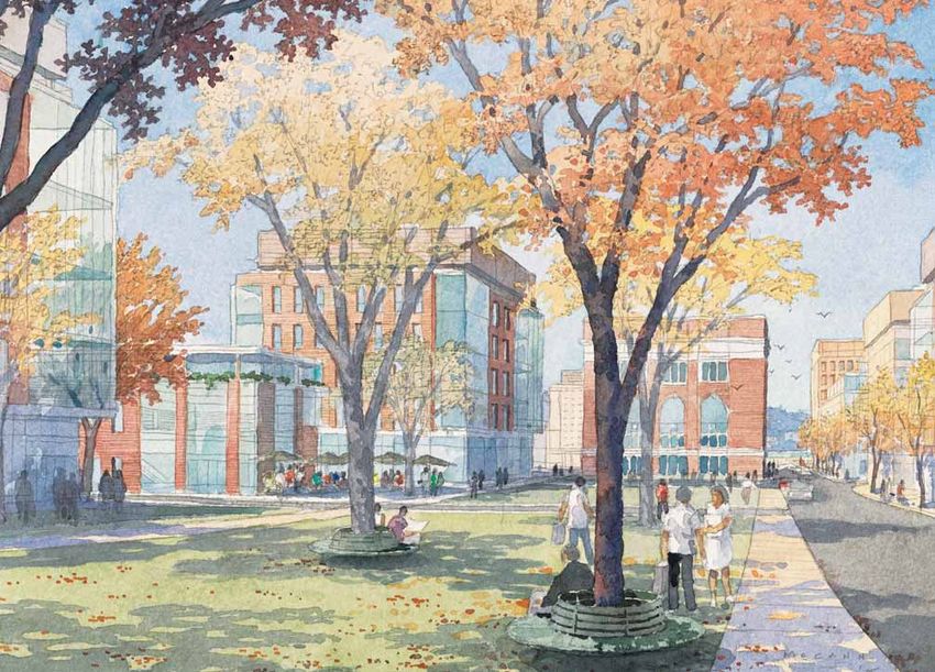
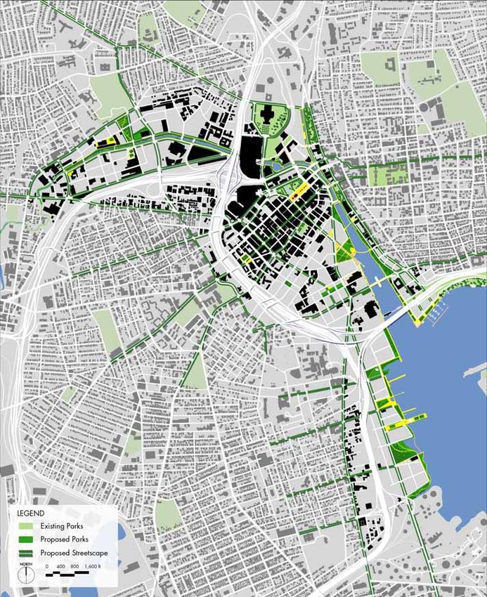
PROVIDENCE 2020 17PA R K S A N D P U BL I C SPAC ES
Public spaces embody aspirations for balancing the • Narragansett Bay Parks – New waterfront parks at the
commercial use of real estate with the need for public foot of Blackstone Street, Public Street, Oxford Street,
gathering areas, quiet respite from hectic activity, and the and Thurbers Avenue, and continuous public access
restorative qualities of natural environments. In downtown from India Point Park to the Providence River and south
Providence, the system of parks will celebrate the water to Thurbers Avenue.
and highlight the character of each distinct district (Figure
Waterfront parks naturally should promote the direct use
20).
of the water (Figure 22). Programming and improvements
Waterplace Park and Riverwalk feature continuous paths to facilitate this use should be designed into each park.
along the river that are already an amenity. This concept Fishing, bird watching, and educational opportunities
of continuous public access needs to extend west along should be featured on the Woonasquatucket River. The
the banks of the Woonasquatucket River in the Promenade Providence River is already well known for the Waterfire
and south along the banks of the Providence River and events that draw thousands of people to the water’s edge
Narragansett Bayfront. This greenway will interconnect the each summer. Small boating and recreational fishing will
larger downtown area. be appropriate in this urban stretch of waterfront. The
Narragansett Bayfront should promote fishing and boating
Providence will become known for its waterfront parks, activities. Improvements to existing fishing piers, new
each a unique destination within the downtown (Figure 21). piers where appropriate, and the infrastructure to support
Each park will have special features and interpretive recreational fishing will enhance this activity. New marinas,
elements that connect it to its setting and to the community boating, and transient boat slips will promote
surrounding neighborhoods, while also welcoming all day-to-day use of the upper bay, although protection from
residents and visitors into a system of parks. Waterplace the high velocity zone may be warranted.
Park, the Providence Riverwalk, Collier Park, and India
Point Park are the only points of public access in the Because Promenade, the Jewelry District, and Narragansett
downtown today. The Roger Williams National Memorial Bayfront developed as industrial areas, they lack any civic
Park and the Gardiner Jackson Park (Memorial Park) upland parks (Figure 23) . The only existing urban parks are
between Canal Street and Main Street have a presence on found within Downcity, including Burnside Park, the Bank of
the water as well. America Skating Center, Cathedral Square, Grace Square
and Freeman Park, and other small plazas and courtyards.
In the future, the existing parks will be complemented In order to create a civic realm in the former industrial lands
by new waterfront parks and continuous public access, and to create a sense of place for parts of Downcity, several
including: new parks are proposed to complement surrounding
development:
• Harbor Landing Park – a major civic gathering space on
the Providence River at the convergence of Downcity and • Heritage Harbor Parks – a series of small open spaces
Jewelry District streets. along South Street as a focal point in the Jewelry District.
• Providence Riverwalk - extensions to the mouth of the • Claverick Square – a public square on the hillside
river on the east bank and an extension to Point Street, at between Friendship and Clifford Streets.
a minimum, on the west bank.
• LaSalle and Emmett Square – street realignment to
• Woonasquatucket River Greenway – improvements introduce green open space within these intersections.
to the water’s edge and continuous trail systems from
Providence Place Mall to Eagle Square and beyond to the • Acorn Street Park – a significant open space along the
city line. Woonasquatucket River to connect to the neighborhoods
to the north.
18 PROVIDENCE 2020^ FIGURE 20 Civic Realm Each neighborhood and
district will have a landing on the water. With continuous
public access, the waterfront will become a regional
recreational resource.
PROVIDENCE 2020 19Improvements to the parks within downtown Providence US Route 6/RI Route 10 is another major corridor providing
will help provide needed connections for regional trail access to the neighborhoods on the west side of the city
systems, many of which now stop just outside the city. and the western suburbs. This alignment, which parallels
The East Coast Greenway is a bicycle trail between Maine Amtrak’s Northeast Corridor along the Woonasquatucket
and Florida with gaps in the Providence segment between Valley, clearly demarcates the high ground of Federal
Pawtucket and Cranston. The East Bay Bike Path is Hill from the industrialized district in the valley in the
complete through East Providence, but could continue Promenade District.
west through Providence. The Pawtuxet River Greenway
connects through the city to the Allens Avenue Bikeway Key arrival points for the different downtown districts
extending south to Cranston. Riverfront improvements in are as follows:
the Promenade district are part of the Woonasquatucket
1. Capital Center/Downcity - Memorial Boulevard and
River Greenway and the American Heritage River Corridor.
Francis Street are the primary points of entry for visitors
from the full interchange of Interstate 95 and Route 6.
GAT E WAY S AND T H E SEQUENCE
O F A R R IVA L 2. Downcity/Jewelry District – Service Road Numbers 7
A well-choreographed arrival into downtown is easy to (Sekell Street) and 8 (Franklin Street) run continuously
understand, offers clear signage, and features the best along either side of Interstate 95 leading to major cross
attributes of the city at the gateway locations, (Figure 21). streets; access onto the service roads will occur at Point
This sequence begins at the regional highway network and Street, Broadway (northbound), and Atwells Avenue
leads to the primary street corridors into downtown. While (southbound).
providing excellent access into downtown, these highways
3. Promenade – Providence Place has a mid-block arrival
separate downtown from the neighborhoods and present
from Interstate 95 southbound and a gateway location at
many challenging decisions to the visitor trying to reach
the Pleasant Valley Parkway intersection for arrival from
downtown.
Interstate 95 north or southbound.
The sequence of arrival into downtown Providence is
4. Federal Hill/Promenade – Dean Street is the arrival point
dominated by the Interstate 95 corridor, which is permeated
from Route 6 eastbound.
with many exit and entrance ramps. This highway acts
almost like a local road, including both the highway itself 5. Narragansett Bay – Thurbers Avenue has a full
and its two parallel service roads. interchange with Interstate 95.
Interstate 195 is a major connection to East Providence and 6. Rhode Island Hospital – Borden Street (Interstate 95
the metropolitan area east of Narragansett Bay, and also southbound) and Eddy Street at Willard (Interstate 195
serves as the through-route from Interstate 95 east to Cape westbound) will provide direct access from the highway.
Cod. The Interstate 195 corridor through the downtown
7. Capital Center – Orms Street and State Street are
is currently being relocated from an alignment that cuts
gateways from Interstate 95 northbound; Route 246
between Downcity and the Jewelry District to an alignment
follows a circuitous route to Orms Street and to Canal
that falls south of Point Street, between the Jewelry District
Street from Interstate 95 southbound.
and Narragansett Bay.
8. Fox Point – Point Street at Wickenden Street and Main is
the exit from Interstate 195 westbound.
These gateways define the street hierarchy for local access
and should be the focus of investment.
20 PROVIDENCE 20207 7
3 3
1
4
2
2
8
2
6
6
5
5
^ FIGURE 21 Gateways The Key arrival points from
Gateway Points of Arrival
the regional highways to the city streets should
be celebrated.
PROVIDENCE 2020 21S TR E E T H IE R AR C HY
In Providence, many streets lead from great distances Valley Street/Orms Street and Harris Street are secondary
to the water’s edge where commercial activity and streets that parallel the water in the Promenade district.
transportation were centered. Other streets parallel the
waterfront or connect across the hills above the downtown. The network of streets move cars and pedestrians, and
Many of these primary streets are the gateways into form important social spaces where face to face meetings
downtown, leading either from the neighborhoods or can occur spontaneously. As well-lit, tree lined corridors,
from the regional highway system (Figure 23). As such the the streets can welcome visitors and orient them on their
primary streets need signage and consistent streetscape journey downtown. While the street and block pattern are
to call attention to their role in orienting visitors to the relatively fixed over time, wide variations can occur within
downtown. the blocks.
Primary streets that serve as gateways and connect When streets are blocked by highways, rails, or superblock
neighborhoods to the water are: development, the physical connections in the city break
down, altering perceptions of the downtown. Occasionally
• Thurbers Avenue opportunities arise to reconnect the fabric of the city, as in
• Point Street the case of the relocation of the Interstate 195 right-of-way.
• Weybosset Street/Broad Street Where highways and rail corridors remain, heroic attempts
• Westminster Street are needed to overcome these barriers and strengthen
connections between downtown and its neighborhoods.
• Washington Street
These efforts involve improvements to existing bridges to
• Broadway Street/Fountain/Sabin/Exchange Street/Angell
make them more pedestrian-friendly and where appropriate
Street
the introduction of new vehicular and/or pedestrian
• Smith Street to the Roger Williams National Memorial
bridges. Other gateway streets from the neighborhood
Park
to the downtown are defined by highway bridges and
Primary streets that run along the side of the hills are: underpasses including:
• Dean to Pleasant Valley Street (also leads to water) • College Street
• Service Roads 7 (Sekell Street) and 8 (Franklin Street) • Pine Street
• Atwells Avenue/Empire/Chestnut • Clifford Street
• Dorrance Street/Francis Street (also leads to water) • Blackstone Street
• Eddy Avenue • Public Street
• Benefit Street • Oxford Street
Streets that directly parallel the water are: These crossings should be designed to be pedestrian-
• North Main Street/South Water Street friendly streets, with active uses along their edges.
• Memorial Boulevard
• Providence Place
• Promenade Street
• Allens Avenue
22 PROVIDENCE 2020PL
EA
SA
SMITH STR
EET
NT
VA
LL
FR
EY
AN
PK
CI
S
Y
SO
BE
UT
NE AIN
ATWELLS AV
H
ENUE
FI
M
T
DE
ST
AN
RE
ST
ET
ST
RE
AY
RE
ADW
ET
BRO
ET
T
EE
S TR
INT
FR PO
EET
STER STR AN
WESTMIN KL
IN
EDDY STREET
UE
VEN
BE RS A
THUR
UE N
AVE
ENS
ALL
^ FIGURE 22 Street Hierarchy & Development Framework
Streetscape improvements along key corridors will connect
districts to each other, the neighborhoods, and the water.
Retail will be concentrated in key locations in each district.
PROVIDENCE 2020 23PUBL IC PA RK I N G
Publicly-financed parking structures create a supply of The proposed transit concept for downtown Providence will
parking that can be shared among users, supplementing link the Valley to the Bay along a spine that runs generally
parking that the private sector provides and creating a along Valley Street, Providence Place, Memorial Boulevard,
convenient pool for visitors in the downtown area. Parking Eddy Street, and Allens Avenue (Figure 23). Service along
structures should be strategically located across downtown, this route could begin with a rubber-wheel trolley and could
each one serving a walkable zone and complementing key evolve into a bus rapid transit system, with the ability to
private sector investments. Ideally these are located so override traffic signals, dedicated lanes where possible,
that there is a seamless arrival from the regional highway and digital information at stops to keep riders informed
network on to gateway streets and into a parking structure (Figure 25). The suggested route includes some of the wider
that is close enough to walk to key downtown destinations. thoroughfares in the city, but further study will be required
to establish the exact route.
In the tear drop area that includes Capital Center, Downcity,
and the Jewelry District, four key sites for initial parking Spaced at approximately one-half mile intervals, transit
structures would be located at: stops will serve a five-minute walk zone in the downtown.
Stops would be targeted for Olneyville, Eagle Square, Acorn
1. LaSalle Square – Close to the Broadway entry to the city Street, the Foundry, Washington Street near Kennedy Plaza,
and serving the area around the convention center and Ship Street, the Rhode Island Hospital, and Oxford Street.
much of Downcity. A certain number of these stops could serve as intermodal
2. Garrahy Courthouse – Close to the Friendship and centers, with transfers to the regional RIPTA buses and
Clifford Interstate 95 gateways and serving both the public parking structures. Spaced every mile, possible
Jewelry District and Downcity. intermodal locations would be at Olneyville, near Kennedy
Plaza, near Rhode Island Hospital, and near Thurbers
3. South of Point Street – Close to the Point Street and Avenue. Many of the regional bus riders that are not
Eddy Street gateways and serving most of the Jewelry destined for downtown could transfer at one of the outlying
District. intermodal stations.
4. Capital Center - A public garage in the vicinity of the
The Providence trolley system, LINK, puts the city ahead
Citizens Headquarters and the Amtrak station would
of many of its counterparts by offering short haul trips
serve the financial district in Downcity, the State House
across downtown and servicing key destinations (Figure
and the lower part of College Hill.
26). The Green Line connects Eagle Square to Kennedy
Plaza via Atwells Avenue, running past the Dunkin’ Donuts
Center, and the Convention Center. To the east, the Green
TRA N S IT Line continues on via the bus tunnel to Thayer Street and
Transit systems represent an investment in infrastructure south to Wickenden Street. The Gold Line connects the
that leverages private development, just as any utility State House area, Providence Place Mall, Kennedy Plaza,
would. Stations associated with transit are an opportunity Downcity, and the Rhode Island Hospital.
to create memorable civic architecture and to create a
Many residential areas will be within a ten-minute walk of
more desirable location for private development. As a
the proposed transit spine. Additional trolley lines may be
system, transit is typically organized into primary routes
necessary over time, however, to provide better service
and secondary feeder routes that promote connectivity
to some downtown neighborhoods, particularly in the
and ridership. Primary routes need to provide express
west end. Through a connected system, businesses and
service with frequent headways, and typically require a
residents will be able to move back and forth through the
wider right-of-way to achieve these efficiencies. Transit can
downtown districts. Regional riders will be able to join the
evolve over time, which is an important concept in today’s
system and local residents will have access through the
funding environment. While RIPTA serves all of Rhode
trolley system that feeds into the transit spine.
Island, downtown Providence will have a different set of
needs that emphasizes local connections, transit oriented
development, and reduction in the use of the automobile
and its attendant street and parking demands.
24 PROVIDENCE 2020^ FIGURE 23 Transit A transit spine will link each district along the valley and the bay,
with a series of stops that pick up a five-minute walk radius. The transit could begin as
rubber wheel trolleys and evolve into bus rapid transit or light rail. Intermodal stations
will provide parking and interface with the existing trolley system.
PROVIDENCE 2020 2526 PROVIDENCE 2020
The economic development strategy for the City of Providence centers            DEVELOPMENT
around strengthening the tax base, making jobs available for all workers,
and promoting Smart Growth, which involves compact mixed-use districts          OPPORTUNITIES
integrated with public transit. In building a sustainable economy for the
future, the city is looking to build on the strengths of entrepreneurs and
institutions, focusing on knowledge, creativity, and innovation. Providence’s
competitive advantages are built around the following five industry clusters,
which were identified in the 2003 report, “A Report: Building Providence’s
Creative and Innovative Economy”:

1. Arts and culture
2. Knowledge creation
3. Biomedical science
4. Creative and information technology
5. Design and business innovation

                                                                                  PROVIDENCE 2020   27
“Buzz” is happening around Providence. This is largely As would be expected for a college town, Providence’s
due to major public and private projects that have and population has a higher concentration of persons of 15
continue to transform the City. These initiatives coupled to 19 and 20 to 24 years old, as compared to national
with the strength of the regional economy demonstrate that averages. Among the top 50 metropolitan areas in the
“something is happening in Providence.” Recent initiatives United States, however, Providence’s share of 25 to 34 year
include: olds was low. Providence ranked 42nd among the nation’s
50 largest metro areas in its share of population aged 25 to
• Two buried rivers that run through the downtown were 34, and this cohort is declining faster in Providence than the
uncovered and reconnected within the city’s historic national average.
downtown;
In the new economy the challenge will be to attract the
• The elevated rail line that cut through the city’s downtown
young, talented workers in the 25 to 34 year old cohort.
was buried and the land reclaimed for civic spaces and
They are needed for jobs, they are mobile, and, often,
quality development sites;
looking to set down roots. At the same time, workforce
• The Capital Center project created civic improvements training will be imperative to ensure that diversity and
and development opportunities in a previously population growth are an economic asset.
dilapidated area;
• Waterplace Park created a new civic space in the center
of the City; ECONOMIC CHARACTERISTICS
Providence is functionally part of the Boston Metro
• Providence Place Mall made the city a regional retail
economy, which is one of the strongest economic regions in
center; and,
the country. It also participates in the Northeast Economic
• The planned relocation of Interstate 195 will reconnect Region, which is a global economic force. The city is home
Downcity to the Jewelry District. to seven colleges and universities and functions as the
health services center for the state. Regional highways,
The question from a market standpoint is whether this Amtrak, and the T.F. Green Airport, which was remodeled
“buzz” can be leveraged to transform and grow the in the mid-1990s, provide excellent access. Providence is
economy (Figures 24 & 25). within a 45-minute car or train ride to downtown Boston
and within a three-hour car or train ride to New York City.
As of 2002, the Providence Metro Area contained over
D E M O G R A PH I C T R ENDS
26,000 businesses and approximately half a million private
As the capital of Rhode Island and the center of the
sector jobs. In 2004, over 23 percent of all of the private
State’s economy, the Providence/New Bedford/Fall River
sector jobs in Rhode Island were located in Providence.
Metropolitan Statistical Area (Providence MSA) contains
According to the 2000 Census, eleven percent of employed
over 1.5 million people and includes most of the State of
Rhode Islanders worked in Massachusetts up from 9.7
Rhode Island and part of southeastern Massachusetts.
percent in 1990. As compared to the national average,
As of the 2000 census, Providence was the 40th largest
the state has a higher share of its employment in the
metropolitan area in the United States. The average annual
manufacturing, finance, educational services, healthcare
growth rate for the MSA is 4.8 percent, which is just
and accommodation and food service industries.
lower than the metropolitan growth rate for Stamford (6.6
percent), Boston (6.2 percent) and Worcester (5.8 percent). Education is a dominant employment cluster and critical
The relatively small Manchester/Nashua MSA (13.3 percent) to fostering the Providence’s “creative economy.” It is also
is growing fastest and the metropolitan areas for Hartford seen as a vehicle for inner city workforce development
and Springfield are lagging at two percent or less. and technology commercialization. Increasingly, Brown,
Lifespan and CARE New England are seeding Rhode
Providence is the second largest city in New England with
Island’s biomedical cluster. Rhode Island’s high wage
177,300 residents in 2004. The population of the city is
jobs information, management of companies and finance,
increasing in diversity. From 1990 to 2000, the population
insurance and real estate are concentrated in Providence
increased by eight percent, fueled largely by the growth
County, where 60 percent of the state’s education service
in the Hispanic population, which more than doubled.
jobs are found.
28 PROVIDENCE 2020While Rhode Island’s private sector employment growth 1. Arts and culture – This bookend cluster combines some
rate was on average lower than most of the New England commercial with mostly non-profit industries. There are
states between 1992 and 2002, Rhode Island did not performing arts organizations emerging such as Black
experience dramatic private sector employment gains Rep and established ones like the Providence Performing
and losses during this period. Rhode Island’s relatively Arts Center. The cluster includes thousands of individual
low employment growth rate was more a function of not artists in many neighborhoods, including animators,
capitalizing on the late 1990s boom and less about losing filmmakers, and fashion designers. Arts and culture are
jobs as a result of the recession. the cultural street scene, music of the world’s cultures
and the third places like cafés and bars (after home
A major factor cited compromising Rhode Island’s ability and work) that are fundamental to city life. Public artists
to compete for jobs is high taxes. In a January 2004 create the larger public aesthetic ground in the city for art
publication by Ernst & Young entitled “Total State and and culture to flourish. Creative workers crave a vibrant
Local Business Taxes: A 50-State Study of the Taxes artful street scene to rest, have fun, and network with
Paid by Business in FY 2003”, Rhode Island ranked 9th in others. Further, people want to visit and be part of these
business taxes per employee. Massachusetts ranked 27th artful experiences: cultural tourism.
in business taxes per employee. Economic development
publications recommend that the state’s competitiveness 2. Knowledge creation - The seven colleges and
can be improved by reducing the government’s reliance universities are storehouses and creators of knowledge.
on property taxes and reducing some state taxes. A report The colleges’ buying power is an economic force.
by the Initiative for a Competitive Inner City states that the Combined they are the largest private employer in the
combined state and local tax burden on electric utilities in city. Their presence ripples in the economy; restaurant
Rhode Island is estimated to be approximately three times patronage and attendance at arts events would pale
the state and local tax burden in Massachusetts. without the places of knowledge in the city. Places of
knowledge serve as an entrepreneurial engine, since
they produce research that is commercialized into
products for the market, seed new economic clusters
PO S IT IO N IN G T H E ECONOMY such as biomedical science, help solve business and
Providence is bringing art and science to the market. The technological problems in entrepreneurial start-ups, and
creative and innovative industry clusters identified in the provide jobs for graduates who become creative workers
2003 report are arts and culture, knowledge creation, and entrepreneurs.
biomedical science, creative and information technology,
and design and business innovation. These clusters 3. Biomedical science - New breakthroughs in
represent 20,000 jobs in Providence, which is 18 percent of pharmacology, treatment and medical devices are in this
the total number of jobs. The presence of the 20,000 jobs cluster. The federal government invests $100 million per
anchors another 40,000 jobs, indicating that 54 percent of year in Providence hospitals and Brown Medical School
the economy is creativity-driven. to develop breakthrough solutions in medicine. Lifespan
and Care New England employ 750 medical researchers
The two clusters that bookend the industry clusters are on major projects. This number is up by 500 workers in
mostly tax-exempt and civic. At one end is knowledge the past three years.
creation from seven colleges and universities and five
4. Creative and information technology - This technology
teaching and research hospitals. At the other end is art and
cluster is where art and science converge in new
culture. These two bookend clusters provide the foundation
products and new applications such as digital imaging
for the three commercial clusters to flourish.
and smart processes. Creators include programmers,
The presence and interaction of these five clusters are the web artists, and software engineers.
foundation of the creative economy. The interaction among
5. Design and business innovation - Jobs include graphic
the disciplines produces new combinations that have
and industrial design, marketing, PR and intellectual
economic, artistic and social impact for Providence.
property lawyers.
PROVIDENCE 2020 29You can also read