EARTHQUAKES Progress Made to Implement Early Warning System, but Actions Needed to Improve Program Management - Report to Congressional Committees
←
→
Page content transcription
If your browser does not render page correctly, please read the page content below
United States Government Accountability Office
             Report to Congressional Committees

             EARTHQUAKES
March 2021

             Progress Made to
             Implement Early
             Warning System, but
             Actions Needed to
             Improve Program
             Management

GAO-21-129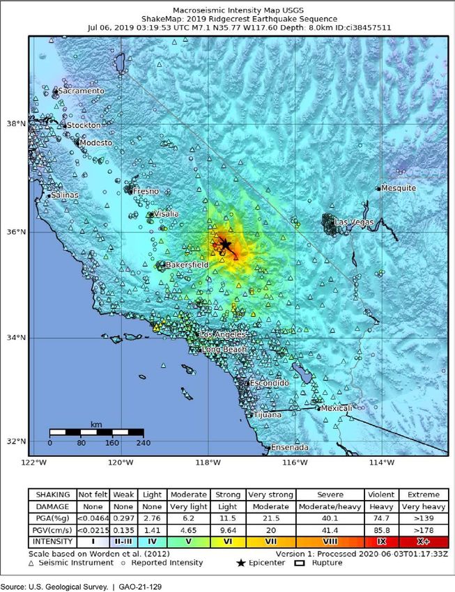
March 2021

                                            EARTHQUAKES
                                            Progress Made to Implement Early Warning System,
                                            but Actions Needed to Improve Program Management
Highlights of GAO-21-129, a report to
congressional committees

Why GAO Did This Study                      What GAO Found
Earthquakes and related hazards are a       The U.S. Geological Survey (USGS), through its Earthquake Hazards Program
significant threat to people and            (EHP), has made several efforts to identify the dangers from earthquakes, such
infrastructure in the U.S. For instance,    as tsunamis and landslides, to inform the public and help decision-makers
magnitude 6.4 and 7.1 earthquakes           ensure public safety and mitigate losses. For example, USGS publishes national
centered west of Searles Valley in          seismic hazard maps, which are used to strengthen building codes throughout
California, struck in July 2019, causing    the nation. USGS officials, state geologists, and other stakeholders GAO
over $5 billion in damage. USGS is the      interviewed stated that the program’s capacity to meet its mission has been
lead federal agency for providing           impeded by flat discretionary resources for its core capabilities, such as
earthquake monitoring and notification.
                                            conducting applied science research or urban hazard assessments.
USGS began implementing
ShakeAlert, its earthquake early            In response, USGS implemented cost-cutting and cost-saving actions to meet
warning system, in California, Oregon,      EHP’s mission that are consistent with some but not all leading practices for
and Washington State in 2012.               strategic planning, performance measurement, and human capital planning
                                            identified in past GAO work. For example, USGS lacks a strategic plan that,
GAO was asked to assess, among              among other things, identifies the resources needed to achieve the EHP’s
other things, USGS efforts to identify      mission and goals for all major functions of the EHP, such as conducting applied
earthquake hazards. This report             earthquake science research or urban hazard assessments. Further, USGS has
addresses, among other things, (1)          not conducted an analysis of staffing needs consistent with leading practices for
USGS actions to identify earthquake
                                            effective strategic workforce planning principles, such an analysis could include
hazards, (2) the extent USGS actions
                                            succession planning and a data-driven assessment of its needs for critical skills
to achieve its earthquake hazard
mission meet leading practices; and (3)     and competencies. By developing a strategic plan that identifies the strategies,
what progress USGS and its partners         priorities, and resources needed to reach these goals and conducting a staffing
have made implementing ShakeAlert.          gap analysis, USGS can better ensure it has well-thought-out strategies to
GAO evaluated agency guidance and           achieve results-oriented goals with Congress understanding the tradeoffs USGS
other planning documents, such as           made in applying its resources toward its goals.
USGS’s ShakeAlert implementation            USGS has made progress implementing seismic stations; however, some
plans; assessed its ShakeAlert cost
                                            challenges remain to fully implement the ShakeAlert system. GAO found that
estimate; conducted site visits to
                                            USGS had not followed best practices in establishing schedules, milestones, and
selected cities; and interviewed federal
and state officials, among others.
                                            timeframes for its ShakeAlert implementation, and has not completed its plan for
                                            coordinating outreach with stakeholders. By developing schedules and
What GAO Recommends                         milestones, USGS will be able to track completion of key activities that impact the
                                            overall cost of ShakeAlert. By updating and completing its ShakeAlert outreach
GAO is making 7 recommendations,            plan, USGS can better ensure all stakeholders have a shared understanding of
including that USGS develop a
                                            how to communicate and educate the public on the ShakeAlert system.
strategic plan, including measures, and
conduct a staffing gap analysis for the     Engineers Installing an Earthquake Early Warning Seismic Station on Mt. St. Helens
EHP that identifies the resources
needed to achieve its mission and
goals; follow best practices for a
comprehensive ShakeAlert cost
estimate; and complete the
stakeholder outreach plan for its
earthquake early warning system.
USGS generally concurred with GAO’s
recommendations
View GAO-21-129. For more information,
contact Chris Currie at (404) 679-1875 or
curriec@gao.gov.

                                                                                         United States Government Accountability Office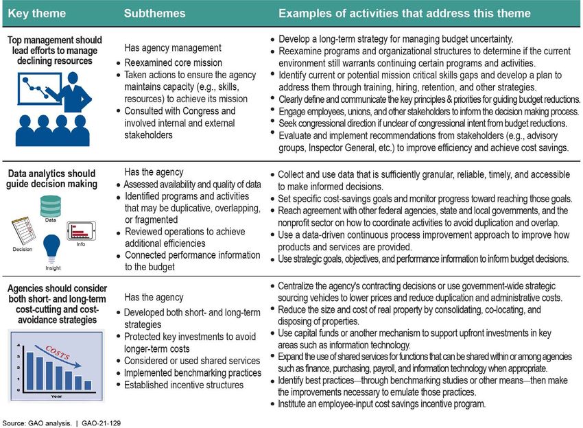
Contents

Letter                                                                                    1
               Background                                                                 7
               USGS Has Several Efforts to Identify Earthquake Hazards that
                 Stakeholders Report Are Impeded by Resource Challenges                 15
               USGS Has Taken Actions to Ensure the Earthquake Hazards
                 Program Meets Its Mission but Has Not Followed Leading
                 Practices for Strategic Planning, Performance Measurement,
                 and Human Capital                                                      30
               USGS and Its Partners Have Implemented Seismic Stations for
                 the Early Warning System, but Several Challenges Remain                39
               USGS and NOAA Have Established But Not Fully Implemented a
                 Memorandum of Understanding for Coordinating and Sharing
                 Tsunami Related Information                                            59
               Conclusions                                                              62
               Recommendations for Executive Action                                     63
               Agency Comments                                                          65

Appendix I     Objectives, Scope, and Methodology                                       71

Appendix II    Examples of U.S. Geological Survey Products on Earthquake
               Severity and Damage                                                      79

Appendix III   Efforts to Expedite the Permitting Process for Installing Seismic
               Stations                                                                 84

Appendix IV    Comments from the Department of the Interior                             86

Appendix V     GAO Contact and Staff Acknowledgments                                    90

Tables
               Table 1: Actions Related to Using Data Analytics to Guide
                       Decision-Making Reported by U.S. Geological Survey
                       (USGS)                                                           32

               Page i                                                 GAO-21-129 Earthquakes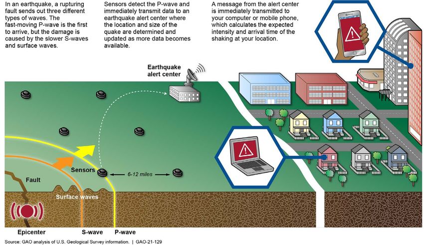
Table 2: Actions Related to Using Data Analytics to Guide
Decision-Making Reported by U.S. Geological Survey
(USGS) 33
Table 3: Short and Long-term Cost Cutting and Cost Avoidance
Actions Reported by U.S. Geological Survey (USGS) 34
Table 4: Summary of Our Assessment of U.S. Geological Survey
Cost Estimate for ShakeAlert Compared to Best Practices
of a Comprehensive Cost Characteristic 44
Table 5: Summary of Challenges Identified by the Organizations
Adopting Earthquake Early Warning (EEW) Application
Systems 50
Table 6: Number of Seismic Stations and Systems Needing
Permits on Federal, State, and Private-owned Lands as of
August 2020 84
Figures
Figure 1: Earthquake Hazards and Their Effects 8
Figure 2: Modified Mercalli Intensity Scale 9
Figure 3: ShakeAlert Issuance of Earthquake Early Warning Alerts 15
Figure 4: Advanced National Seismic System (ANSS) stations
across the U.S. 18
Figure 5: Example of a U.S. Geological Survey National Seismic
Hazard Map for the Probability of a Modified Mercalli
Intensity 6 Earthquake in 100 Years, Expressed as a
Percentage 21
Figure 6: Overview of GAO’s Framework for Examining Agencies’
Efforts to Manage Declining Resources 31
Figure 7: Percent of ShakeAlert Seismic Stations Operating in the
California Integrated Seismic Network and the Pacific
Northwest Seismic Network as of August 31, 2020 41
Figure 8: Alerting Capabilities through the Integrated Public Alert
and Warning System 51
Figure 9: Prompt Assessment of Global Earthquakes for
Response Issued for 2018 Earthquake in Anchorage,
Alaska 80
Figure 10: ShakeMap for 2019 Earthquake in Ridgecrest,
California 81
Figure 11: Aftershock Forecast for 2020 Earthquake in Indios,
Puerto Rico 82
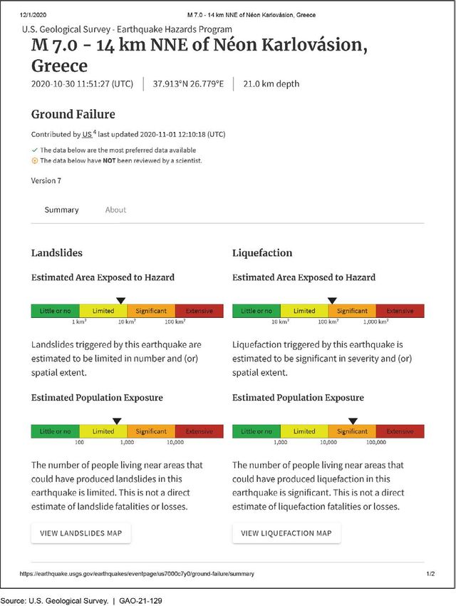
Figure 12: Ground Failure Product Issued for 2020 Néon
Karlovásion, Greece Earthquake 83
Page ii GAO-21-129 Earthquakes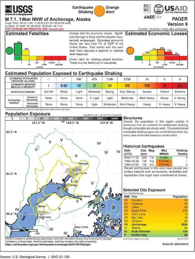
Abbreviations

ANSS                       Advanced National Seismic System
EHP                        Earthquake Hazards Program
EEW                        Earthquake Early Warning
FEMA                       Federal Emergency Management Agency
IPAWS                      Integrated Public Alert and Warnings System
MOU                        Memorandum of Understanding
NOAA                       National Oceanic and Atmospheric Administration
NWS                        National Weather Service
USGS                       U.S. Geological Survey
WBS                        Work Breakdown Schedule
WEA                        Wireless Emergency Alert

This is a work of the U.S. government and is not subject to copyright protection in the
United States. The published product may be reproduced and distributed in its entirety
without further permission from GAO. However, because this work may contain
copyrighted images or other material, permission from the copyright holder may be
necessary if you wish to reproduce this material separately.

Page iii                                                          GAO-21-129 Earthquakes
Letter

441 G St. N.W.
Washington, DC 20548

                       March 25, 2021

                       Congressional Committees

                       Earthquakes and related seismic activity pose a significant threat to
                       people and infrastructure. Recent major earthquakes are examples of the
                       power of such threats. For instance, a magnitude 6.4 earthquake
                       centered west of the Searles Valley in California, struck on July 4, 2019,
                       followed by a magnitude 7.1 earthquake the next day. 1 The U.S. Navy
                       estimated the damage from these earthquakes to its China Lake Naval
                       Air Weapons Station to be over $5 billion. In addition, the southwestern
                       part of Puerto Rico has been struck by a swarm of earthquakes that
                       began on December 28, 2019, and continued into 2020. As of February
                       2021, the southwestern part of the island experienced 15 magnitude 5.0
                       or greater earthquakes with an estimated $1 billion in damages. 2 USGS,
                       the National Oceanic and Atmospheric Administration (NOAA), the
                       National Science Foundation, and state geological surveys share
                       responsibility for identifying and studying earthquake hazards, including
                       tsunamis, liquefaction, and landslides. 3

                       In 1977, the National Earthquake Hazards Reduction Program was
                       established, and includes four federal agencies that coordinate their work
                       together: 1) USGS, 2) the National Science Foundation, 3) the Federal
                       Emergency Management Agency (FEMA), and 4) the National Institute of
                       Standards and Technology. 4 Under the program, the federal government
                       supports efforts to assess and monitor earthquake hazards in the U.S.,
                       and thereby mitigate the risks associated with these hazards and reduce
                       the risks of life and property from future earthquakes. In particular, USGS,

                       1Magnitude   characterizes the relative size of an earthquake and is a measurement of the
                       maximum motion recorded by a seismograph. The severity of an earthquake can be
                       expressed in terms of both intensity and magnitude. Intensity is based on the observed
                       effects of ground shaking on people, buildings, and natural features and varies from place
                       to place within the disturbed region. Magnitude is related to the amount of seismic energy
                       released at the center of the earthquake.
                       2According to USGS, the mainshock occurred on January 7, 2020, and was a magnitude
                       6.4 earthquake. As of February 2021, the latest earthquake of magnitude 5.0 or higher
                       occurred on July 3, 2020.
                       3According  to USGS liquefaction occurs when loosely packed, water-logged sediments at
                       or near the ground surface lose their strength in response to strong ground shaking.
                       442   U.S.C. § 7704.

                       Page 1                                                            GAO-21-129 Earthquakes
through its Earthquake Hazards Program (EHP), is the federal entity
responsible for identifying earthquake hazards including earthquake
monitoring and notification, assessing national and regional seismic
hazards, conducting applied scientific research to improve these
functions, and coordinating post-earthquake investigation under the
program. 5 USGS also began implementing an earthquake early warning
(EEW) system, known as ShakeAlert, in California, Oregon, and
Washington in 2011. In addition, NOAA’s National Weather Service
(NWS) is responsible for federal tsunami detection and warning
activities. 6 State geological surveys also produce hazard maps of
earthquake faults, and ground rupture, liquefaction, landslide and tsunami
inundation zones, among other efforts, to identify earthquake hazards in
their states. 7

We have previously reported about the nation’s preparedness for such
events and various response and recovery challenges that could ensue.
In 2016, we reviewed earthquake risks to federal buildings, finding that
additional actions were needed to identify and mitigate those risks. 8 We
also identified early implementation challenges with ShakeAlert. Among
other things, we recommended that USGS establish a program
management plan that addresses the known challenges for implementing
ShakeAlert, which USGS fully implemented in November 2017. In
addition, in 2010, we reported that NOAA’s strategic plans for the
National Tsunami Hazard Mitigation Program included most of the
components of effective strategic plans, but other necessary components
were missing or incomplete. 9 We recommended NOAA revise the plans

542   U.S.C. § 7704(b)(3).
633 U.S.C. § 3204. The National Weather Service (NWS) is an agency within the
Department of Commerce’s National Oceanic and Atmospheric Administration (NOAA),
7The responsibilities of the various state surveys differ from state to state, depending upon
the enabling legislation and the states’ traditions. Almost all serve as a source of basic
geological information for their state governments’ executive, legislative, and judicial
branches. For example, the California Geological Survey is charged with providing
scientific products and services about a state’s geology, seismology and mineral
resources that affect the health, safety, and business interests.
8GAO,  Earthquakes: Additional Actions Needed to Identify and Mitigate Risks to Federal
Buildings and Implement an Early Warning System, GAO-16-680, (Washington, D.C.: Aug
31, 2016).
9GAO,  U.S. Preparedness: NOAA Has Expanded Its Tsunami Programs, but Improved
Planning Could Enhance Effectiveness, GAO-10-490 (Washington, D.C.: Apr 28, 2010).

Page 2                                                             GAO-21-129 Earthquakes
to ensure that they include effective strategies and performance
measures for all goals, which NOAA fully implemented in 2014.

We were asked to review USGS’s efforts to identify earthquake hazards
and implement its earthquake early warning system. 10 This report
addresses the following questions:

(1) what efforts has USGS taken to identify earthquake hazards, and what
challenges have stakeholders reported to such efforts?

(2) what actions has USGS taken to ensure the EHP can meet its
mission, and what additional actions could be taken?

(3) what progress have USGS and its partners made in implementing its
EEW system, and what challenges have they reported?

(4) to what extent have USGS and NOAA coordinated and shared data
when identifying the source and magnitude of an earthquake that may
result in a tsunami?

To address our first objective, we reviewed USGS guidance, such as
Circular 1429: ANSS Current Status, Development Opportunities, and
Priorities for 2017-2027 (referring to the Advanced National Seismic
System), and reports and planning documents relevant to USGS’s efforts
to identify and assess seismic hazards, including developing and
updating earthquake hazard products, such as the National Seismic
Hazard Maps. 11 Further, we interviewed officials from USGS’s EHP
regarding the agency’s efforts to identify earthquakes hazards, and
challenges to doing so. To obtain the perspectives of state officials, we
conducted semi-structured interviews with officials from 16 state
geological surveys to discuss the extent that earthquakes hazards are
identified in their states and the challenges to identifying these hazards,
among other things. 12 While the information gathered during these

10See    Pub. L. No. 115-307, § 4, 132 Stat. 4408, 4414.
11USGS,   ANSS Current Status, Development Opportunities, and Priorities for 2017-2027,
Circular 1429 (Reston, VA: July 2017) and USGS, Reducing Risk Where Tectonic Plates
collide—U.S. Geological Survey subduction zone science plan, Circular 1428 (Reston,
VA: June19, 2017).
12To interview these officials, we conducted two site visits in Seattle, WA, Moffitt Field and
Menlo Park, California prior to the Coronavirus Disease 2019 (COVID-19) pandemic. After
the onset of the pandemic, we interviewed USGS and NOAA officials, as well as state
geological survey officials, via telephone interview or virtual roundtable.

Page 3                                                              GAO-21-129 Earthquakes
interviews cannot be generalized to all states or other stakeholders, it
provides a range of perspectives on a variety of topics relevant to
earthquake hazards and efforts to identify them. Our selection criteria and
other additional details about how we analyzed these responses is
presented in more detail in appendix I.

To determine the trends in the EHP’s resources and their effects on the
program, we reviewed USGS budget requests from fiscal years 2014
through 2021. We also reviewed federal laws and accompanying
Congressional appropriations committee explanatory statements and
reports directing appropriations to the program during this period of
time. 13

To address our second objective, we reviewed USGS guidance and other
documents that detail USGS efforts to manage the program and
compared them to the framework we developed for examining agencies’
efforts to effectively manage in an environment of declining resources
(framework). 14 Examples of the documents reviewed include annual
budget guidance, implementation and performance plans for the
Advanced National Seismic System (ANSS), and compared them to EHP
officials’ testimonial evidence. 15 We interviewed these officials to discuss
the extent that USGS management lead efforts to manage declining
resources. 16

To address our third objective, we reviewed USGS’s 2018 Revised
Technical Implementation Plan and other documents, including the
National Earthquake Hazards Reduction Program Reauthorization Act of
2018. 17 We also conducted interviews with USGS officials and other

13We reviewed these documents during this period of time because appropriations
committees directed appropriations be set aside for the EHP within appropriations made
to USGS, but had not in prior years. For example, see House of Representatives;
Congressional Record, Vol. 165, H11288, Dec. 17, 2019, excerpt from Committee report.
14GAO,  Declining Resources: Selected Agencies Took Steps to Minimize Effects on
Mission but Opportunities Exist for Additional Action, GAO-17-79 (Washington, D.C: Dec.
20, 2016).
15ANSS collects and analyzes seismic and geodetic data on earthquakes, issues
notifications of their occurrence and impacts, and provides data for earthquake research
and the hazard and risk assessments.
16GAO-17-79.

17Pub.   L. No. 115-307,132 Stat. 4408.

Page 4                                                           GAO-21-129 Earthquakes
stakeholders of the ShakeAlert system, including the Northern California
Seismic Network, Pacific Northwest Seismic Network, and academia. We
also conducted semi-structured interviews with seven of the 46
organizations that are operating EEW systems in California, Washington,
and Oregon, and four of the seven licensed technical operators to obtain
their perspectives on the guidance provided by USGS. 18 While the
information gathered during these interviews cannot be generalized to all
46 organizations operating EEW application systems and licensed
technical operators, it provides a range of perspectives on a variety of
topics relevant to earthquake early warning systems and applications.
Our selection criteria and details about how we analyzed these responses
is presented in more detail in appendix I. Further, to determine the extent
USGS experienced challenges using FEMA’s Integrated Public Alert and
Warning System in the delivery of EEW alerts, we reviewed
documentation of two controlled tests and discussed the challenges
identified in the tests with senior USGS officials to determine what steps
USGS is taking to address them.

In addition, to assess the extent USGS followed best practices for
comprehensively estimating the cost for ShakeAlert implementation, we
compared USGS practices from their 2018 cost estimate against the four
best practices for a comprehensive cost estimate identified in our Cost
Estimating and Assessment Guide (Guide). 19 We focused on the
“comprehensive” cost characteristic because, according to our cost guide,
a cost estimate that is not comprehensive cannot fully meet the other best
practice characteristics because it is not complete. 20 Further, to assess
the extent that USGS followed best practices in establishing schedules
and milestones, we reviewed USGS’s 2018 ShakeAlert Technical
Implementation Plan and other relevant documents and interviewed

18The 46 organizations use EEW application systems to alert employees and activate
systems to take protective actions.
19GAO’s   cost guide is a compilation of cost estimating best practices drawn from across
industry and government. GAO Cost Estimating and Assessment Guide: Best Practices
for Developing and Managing Program Costs, GAO-20-195G (Washington, D.C.: March
2020).
20The four best practices defined under the comprehensive cost characteristic (1) includes
all life cycle cost, (2) is based on a technical baseline description, (3) documents all
ground rules and assumptions and, (4) is based on a work breakdown structure. The four
characteristics for establishing a reliable cost estimate are that it is comprehensive, well-
documented, accurate, and credible.

Page 5                                                             GAO-21-129 Earthquakes
relevant USGS officials, and compared the information we gathered to the
best practices from our Schedule Assessment Guide (schedule guide). 21

To assess USGS’s communication, education, and outreach efforts
related to ShakeAlert, we compared USGS’s draft Communication,
Education, and Outreach Plan against collaboration mechanisms to
coordinate program administration. 22 We also reviewed states’ relevant
planning documents such as the Cascadia Region Earthquake
Workgroup’s 2018 Pacific Northwest Strategy for Earthquake Early
Warning Outreach, Education. 23 Additionally, we interviewed USGS
officials and officials from the state emergency management agencies in
California, Oregon, and Washington to discuss USGS efforts and how
USGS and the states collaborate in such efforts. We compared these
documents and information obtained from these interviews against
collaboration mechanisms identified in our prior work for enhancing and
sustaining collaboration among federal agencies, and other
stakeholders. 24

To address our fourth objective, we reviewed the 2016 memorandum of
understanding between USGS and NOAA and interviewed officials from
USGS, NOAA’s National Weather Service, and officials from the state
emergency management offices in California, Oregon, and Washington. 25
We compared the information contained in these documents to the
actions taken by USGS and NOAA as of January 2021 to coordinate and
share information.

21GAO’s  schedule guide is a compilation of best practices associated with developing and
maintaining a reliable, high-quality schedule. GAO, Schedule Assessment Guide: Best
Practices for Project Schedules, GAO-16-89G (Washington, D.C.: December 2015).
22See  “Draft” ShakeAlert Joint Committee for Communication, Education, and Outreach,
Communication, Education, & Outreach (CEO) Plan: 2018 ShakeAlert – Phased Alerting
(July 2018).
23See  Pacific Northwest Strategy for Earthquake Early Warning (EEW) Outreach,
Education, and Training, (March 2018) and Implementing Earthquake Early Warning in
California (May 2018).
24GAO-12-1022.

25Memorandum      of Understanding between the U.S. Geological Survey of the Department
of the Interior and the National Oceanic and Atmospheric Administration of the U.S.
Department of Commerce, (October 2016).

Page 6                                                           GAO-21-129 Earthquakes
Additional details on our scope and methodology are contained in
Appendix I.
We conducted this performance audit from June 2019 to March 2021 in
accordance with generally accepted government auditing standards.
Those standards require that we plan and perform the audit to obtain
sufficient, appropriate evidence to provide a reasonable basis for our
findings and conclusions based on our audit objectives. We believe that
the evidence obtained provides a reasonable basis for our findings and
conclusions based on our audit objectives.
Background
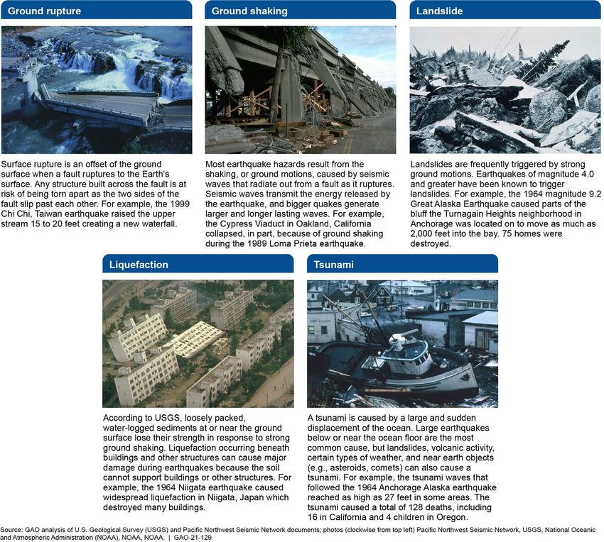
Types of Earthquake Earthquake hazards include any natural physical phenomenon associated
Hazards with an earthquake that may produce adverse effects on human
activities. 26 Earthquakes and their effects proceed as cascades, in which
their primary effects (faulting and ground shaking) induce secondary
effects including surface rupture, landslides, liquefaction, and tsunamis. 27
Figure 1 describes each of these earthquake hazards. These may result
in other destructive effects such as fires and building and critical
infrastructure failures.
26We have previously reported that earthquake hazards and risks are not synonymous.
Earthquake hazards are defined as naturally-occurring phenomena capable of causing
loss or damage. Risk is the potential that exposure to the hazard will lead to a negative
consequence such as loss of life or economic loss. These risks are usually measured in
terms of expected casualties (fatalities and injuries), direct economic losses (repair and
replacement costs), and indirect economic losses (income lost during downtime resulting
from damage to private property or public infrastructure). In any geographic area, three
main factors determine earthquake risks: (1) the level of earthquake hazard, (2) the
number of people and amount of property that are exposed to earthquake hazards, and
(3) how vulnerable these people and property are to the hazards. In contrast, hazard is
generally measured in physical units: energy, shaking strength, or depth of water
inundation. See GAO-16-680.
27Other hazards caused by earthquakes may include fire, flooding, and seiches. A seiche
(pronounced: saysh), is a tsunami-like wave that occurs in an enclosed or partially
enclosed body of water. Seiches have been observed on lakes, reservoirs, swimming
pools, bays, harbors and seas.
Page 7 GAO-21-129 EarthquakesFigure 1: Earthquake Hazards and Their Effects
Page 8 GAO-21-129 EarthquakesAn earthquake’s severity can be measured both in magnitude and intensity. Magnitude is a quantitative measurement of the size of an earthquake. However, intensity is a descriptive measurement of the effect of an earthquake at a given location. Therefore, an earthquake will have a single magnitude, but locations may have different intensity levels depending on their distance from its epicenter. The intensity scale used in the U.S. is the Modified Mercalli Intensity Scale composed of increasing levels of intensity that range from unnoticeable shaking to buildings being destroyed (see fig. 2). 28 Figure 2: Modified Mercalli Intensity Scale 28The lower Roman numerals of the intensity scale generally deal with the manner in which the earthquake is felt by people. The higher Roman numerals of the scale are based on observed structural damage. Page 9 GAO-21-129 Earthquakes
While major earthquakes do not occur as frequently as other natural
                          disasters, such as hurricanes or floods, they can claim many lives and
                          cause unprecedented damage and social and economic upheaval to
                          affected communities such that, according to FEMA, full recovery may not
                          be achievable. The cost of recovering from a major earthquake is
                          estimated to be very high. For example, the 1994 magnitude 6.7
                          Northridge, California earthquake remains the third costliest disaster in
                          U.S. history the most costly earthquake in U.S. history, and one of the
                          most expensive disasters for the federal government. Moreover, FEMA
                          estimates that the average annualized loss from earthquakes to be $6.1
                          billion per year with California alone making up 73 percent of such losses
                          ($3.7 billion). 29

Variation in Earthquake   Portions of all 50 states, the District of Columbia, Puerto Rico, the U.S.
Hazards Across the U.S.   Virgin Islands, and territories in the Pacific are vulnerable to earthquake
                          hazards. 30 However, risks vary greatly across the U.S. and within
and its Territories
                          individual states. Further, in 2015, USGS reported that its estimate of the
                          number of people in the U.S. who live or work in areas with some risk of
                          damaging ground shaking nearly doubled from 75 million to 143 million
                          since 2006. USGS attributed the estimated increase, in part, because of
                          significant population growth in areas vulnerable to earthquakes.

                          Earthquake hazards are greatest in the western part of the U.S.,
                          particularly in California, Alaska, Washington, Oregon, and Hawaii.
                          However, according to USGS, 16 states have the highest earthquake
                          hazard. 31 For example, according to USGS, California has a 99 percent
                          chance of experiencing a magnitude 6.7 or greater earthquake in the next

                          29See Federal Emergency Management Agency, Hazus® Estimated Annualized
                          Earthquake Losses for the United States, FEMA P-366, (Washington, D.C: April, 2017).
                          30According to USGS, the 10 states with highest populations exposed to very strong
                          ground shaking levels are California, Washington, Utah, Tennessee, Oregon, South
                          Carolina, Nevada, Arkansas, Missouri, and Illinois. The Pacific territories that are
                          vulnerable to seismic hazards include Guam, Marianas Islands, American Samoa and
                          neighboring islands.
                          31According to USGS, the states with the highest earthquake hazard are Alaska,
                          Arkansas, California, Hawaii, Idaho, Illinois, Kentucky, Missouri, Montana, Nevada,
                          Oregon, South Carolina, Tennessee, Utah, Washington, and Wyoming. The states with
                          the lowest ground shaking hazard are Florida, Iowa, Minnesota, North Dakota, and
                          Wisconsin.

                          Page 10                                                         GAO-21-129 Earthquakes
30 years. However, areas believed to have low earthquake risk may still experience a damaging earthquake. 32 Since the establishment of the National Earthquake Hazards Reduction Program in 1977, scientific understanding of earthquakes and the technology used to measure and monitor them has improved. Officials are concerned that more areas of the nation may be under greater threat than previously understood. For example, earthquake hazards are now known also to be prominent in the Rocky Mountain region and the New Madrid Seismic Zone, as well as in portions of the eastern seaboard, particularly South Carolina. 33 Further, since the 1990s, research has found that subduction zones, such as the Cascadia Subduction Zone, have historically produced very strong offshore earthquakes (i.e. magnitude 8.0 or higher). 34 According to USGS, there is a higher probability that a major earthquake will occur in these areas. Research has also found that strong earthquakes in these areas produce tsunamis and landslides that cause widespread damage. 35 In addition, the Central 32USGS, UCERF3: A new earthquake forecast for California’s complex fault system, Fact Sheet 2015-3009 (Washington, D.C.: Mar. 2015). On August 23, 2011, a magnitude 5.8 earthquake near Mineral, Virginia occurred. It was felt across more than a dozen U.S. states and Southeastern Canada—an area inhabiting one-third of the U.S. population. Minor and moderate damage to buildings was widespread and estimated to be $200 million to $300 million. 33The New Madrid Seismic Zone includes parts of eight states: Illinois, Indiana, Missouri, Arkansas, Kentucky, Tennessee, Oklahoma, and Mississippi. 34A subduction zone is where two tectonic plates come together, one riding over the other. According to USGS, Alaska, Washington, Oregon, and northern California, the commonwealths of Puerto Rico and the Northern Mariana Islands, US Virgin Islands, Guam, and American Samoa all lie within a subduction zone. The Cascadia Subduction Zone stretches from mid-Vancouver Island in southern British Columbia, Canada to Cape Mendocino in northern California. 35The 1964 magnitude 9.0 earthquake in Anchorage, Alaska, and more recent events in Indonesia, Chile, and Japan provide powerful examples of the potential destructiveness of a subduction zone event Shaking during the 1964 Alaska earthquake was felt as far away as Seattle, Washington, and the tsunamis generated caused about $2.3 billion in damage (2013 dollars).The 2004 Sumatra–Andaman earthquake and ensuing Indian Ocean tsunami killed more than 200,000 people in 14 countries, damaged fisheries in Japan, and triggered earthquakes as far away as Alaska. The tsunami generated by the 2010 Chilean earthquake damaged coastal towns and affected ports as far away as San Diego, California. Nearly 525 people died, and the estimated economic losses range from $15 billion to $30 billion. The 2011 magnitude 9.0 Tohoku, Japan earthquake shook the ground for 5 minutes and generated a tsunami over 100 feet, flung boats atop houses, flooded rural farms with seawater, and caused a meltdown at the Fukushima Daiichi Nuclear Power Plant. Approximately 16,000 people died and damage was estimated to be more than $220 billion. Page 11 GAO-21-129 Earthquakes
and Eastern U.S. has undergone a significant rise in seismicity over the
                           past 6 years. 36 The USGS reported that the growth in seismicity is largely
                           in areas near oil and gas operations, and has been shown to be due to
                           deep injection of fluids.

Federal Agencies’ Roles    Since the establishment of the National Earthquake Hazards Reduction
and Responsibilities for   Program, the federal government has provided support for efforts related
                           to, among other things, assessing and monitoring earthquake hazards
the National Earthquake    and risk. 37
Hazards Reduction
Program                    The National Institute of Standards and Technology is the lead agency
                           and, as such, has the primary responsibility for program planning and
                           coordination of the National Earthquake Hazards Reduction Program.
                           The Institute is also responsible for conducting earthquake engineering
                           research to provide the technical basis for building codes, standards, and
                           practices, and is responsible for working with FEMA and others to
                           implement improved earthquake resistant design guidance for building
                           codes and standards for new and existing buildings. FEMA is responsible
                           for, among other things, promoting better building practices and providing
                           assistance to enable states to improve earthquake preparedness. The
                           National Science Foundation supports basic research to understand
                           geophysical processes of the earth, including the nature and occurrence
                           of geophysical hazards such as seismology. 38 It also supports research to
                           improve safety and performance of buildings, structures, and lifelines.
                           The National Science Foundation also supports social and behavioral
                           research to support more effective risk communication, public

                           36According to USGS, the total number of earthquakes magnitude 3.0 or greater was 867
                           from 1973 to 2008. However, the rate of seismicity in this area increased sharply in 2009.
                           USGS reported there were 3,804 magnitude 3 or greater earthquakes in this area 2009 to
                           2020. Further, there were 1010 such earthquakes in 2015 alone. Multiple damaging
                           earthquakes have occurred during this time period, including a magnitude 5.6 earthquake
                           near Prague, Oklahoma, a magnitude 5.3 earthquake near Trinidad, Colorado; and a
                           magnitude 5.0 near Cushing, Oklahoma.
                           37Pub.  L. No. 95-124, 91 Stat. 1098 (1978) (codified as amended at 42 U.S.C. §§ 7701-
                           7709). The program promotes the development of standards, guidelines, and voluntary
                           building codes, improved design and construction methods, coordinated emergency
                           preparedness plans, and public education and involvement programs
                           38Under federal law, the National Science Foundation is to also work closely with USGS to
                           support applied science in the production of a systematic series of earthquake-related
                           geologic hazard maps, and to identify geographic regions of national concern that should
                           be the focus of targeted solicitations for earthquake-related research proposals. 42 U.S.C.
                           § 7704(b)(4)(iii).

                           Page 12                                                           GAO-21-129 Earthquakes
preparedness, and mitigation policies. USGS is responsible for providing
earthquake monitoring and notification, delivering regional and national
seismic hazard assessments, conducting applied scientific research to
improve these functions, and coordinating post-earthquake investigation.
The National Earthquake Hazards Reduction Program Reauthorization
Act of 2018 also requires USGS to issue earthquake warnings and alerts
to FEMA, the National Institute of Standards and Technology, and state
and local officials when necessary and feasible. 39 USGS’s Earthquake
Hazards Program (EHP) is charged with carrying out these functions.
Identifying and monitoring earthquake hazards are also the responsibility
of state and local government agencies. However, the federal
government is also to provide support through coordinated activities of
the National Earthquake Hazards Reduction Program and the National
Tsunami Hazard Mitigation Program to state agencies. 40
Regarding the National Tsunami Hazard Mitigation Program, NOAA
assists states in emergency planning and in developing maps of potential
coastal inundation for a tsunami. 41 In particular, NOAA’s NWS is
responsible for federal tsunami detection and warning activities. 42
Specifically, NWS operates two tsunami warning centers, which monitor
data from seismic networks operated by NOAA, USGS, the Incorporated
Research Institutions for Seismology, states, and universities, and issue
tsunami warnings. 43
Implementation of USGS is the lead federal agency responsible for developing and
ShakeAlert Earthquake operating ShakeAlert, which is an earthquake early warning system being
implemented in California, Oregon, and Washington. Since 2006, USGS
Early Warning System
has been working with California, Oregon, and Washington state
governments, as well as academic institutions to leverage existing
39See 42 U.S.C. §§ 7704(b)(3)(D).
40See 42 U.S.C. § 7704; NTHMP – 33 U.S.C. § 3204.
41NOAA, FEMA, USGS and 28 U.S. coastal states and territories participate in the
National Hazard
42See 33 U.S.C. § 3204.
43The Incorporated Research Institutions for Seismology is a National Science Foundation
supported consortium of over 100 U.S. universities that operates science facilities for the
acquisition, management, and distribution of seismological data.
Page 13 GAO-21-129 Earthquakesinfrastructure while developing the ShakeAlert system. 44 The purpose of ShakeAlert is to automatically identify and characterize an earthquake rapidly after it begins, estimate the intensity of ground shaking that will result. If ShakeAlert detects an earthquake that is estimated to cause damaging ground shaking, the system issues an alert that may be delivered to the public via the Wireless Emergency Alerting system, public announcement systems, cell phone applications that consumers have downloaded. 45 These alerts warn the public to take protective actions, such as drop, cover, and hold, before strong shaking is expected to arrive at their location. In addition, ShakeAlert delivers data or alerts to automated systems that trigger automated actions, such as shutting down wastewater systems, stopping elevators, slowing down trains, or opening emergency exit doors. Unlike weather forecasts or tsunami warnings, ShakeAlert system can only provide seconds to tens of seconds of warning that shaking is imminent. 46 Figure 3 depicts how ShakeAlert detects and issues earthquake early warning alerts. 44The ShakeAlert system has been sending live alerts to “beta” users in California since January 2012 and in the Pacific Northwest since February 2015. 45The Wireless Emergency Alerting system allows authorized federal, state, territorial, tribal, and local government agencies to send text-like messages to mobile devices in geographically selected areas as one-way cellular broadcasts. 46ShakeAlert cannot deliver alerts before shaking arrives to areas near or at an earthquake’s epicenter. This is because the system needs time to detect the earthquake, issue an alert, and for USGS partners to distribute the alert. Page 14 GAO-21-129 Earthquakes
Figure 3: ShakeAlert Issuance of Earthquake Early Warning Alerts

USGS Has Several
Efforts to Identify
Earthquake Hazards
that Stakeholders
Report Are Impeded
by Resource
Challenges
USGS Efforts to Identify                To meet its mission, USGS, through the EHP, monitors and studies
Earthquake Hazards                      hazards and uses this information to create assessments, provide
                                        warnings, or generate products for anticipating and responding to

                                        Page 15                                             GAO-21-129 Earthquakes
hazardous seismic events. According to USGS, these efforts are to inform the public and decision-makers to ensure public safety, mitigate losses, and improve resilience to earthquake hazards. USGS’s efforts fall into four interrelated categories: (1) monitoring earthquakes; (2) issuing notifications and products on ground shaking severity and damage after an earthquake has occurred, (3) assessing future earthquake risks and hazards, and (4) conducting and supporting scientific research of earthquakes occurrence and the effects of earthquakes. Each type of effort relies on the others. Specifically, scientific assessments of earthquake hazards are necessary to assess vulnerability and risk, which must be determined to effectively prepare and mitigate the effects of these hazards. Decision-makers also need warnings and other information to effectively respond to an earthquake or tsunami. To create assessments and warnings, scientists require a fundamental understanding of the natural processes and observations of the natural events, which are gained through gathering and analyzing data. Data on earthquake hazards and their effects are obtained through seismic monitoring systems and scientific research. The following section includes more detail on the program’s four categories. Monitoring Earthquakes. According to USGS, monitoring provides awareness of the current state of earthquake hazards, and is the basis for short-term forecasts. Specifically, the EHP monitors ground shaking in the U.S. through the ANSS. 47 ANSS is composed of national and regional seismic networks and their associated data centers. 48 The system also includes national components, including the National Earthquake Information Center, National Strong Motion Project, and ShakeAlert (see 47USGS monitors all earthquakes outside the United States through the Global Seismographic Network This network is a partnership between USGS and the National Science Foundation. It provides worldwide monitoring of the Earth, with over 150 seismic stations distributed globally. 48A seismic network consists of a group of stations sending data to a data analysis center. A seismic station consists of a sensor to measure ground motion—a seismometer—and an instrument to convert the analog electrical signal to digital format. Because of the broad range of motions generated by earthquakes, there are usually two types of sensors included in seismic networks: broadband and strong motion. Broadband seismometers can record ground motions (velocity or acceleration) over a wide range of frequencies. Strong-motion seismometers record the shaking near large earthquakes, both on the ground and in buildings and lifelines. Page 16 GAO-21-129 Earthquakes
Elements of the Advanced National Seismic                  sidebar for more information). 49 ANSS and its regional seismic networks
System (ANSS)                                              issue notifications of earthquake occurrence, provide data used to assist
ANSS is composed of regional networks and three            emergency response efforts, and issue products on earthquake severity
national components.
                                                           and damage, which are further discussed below.
Regional seismic networks. ANSS is a
cooperative effort between USGS and regional
networks. Regional seismic networks provide                The data collected by ANSS also supports hazard assessments, such
critical station coverage in moderate- to high-
hazard regions, analyze and distribute seismic data        as the National Seismic Hazard Model, and supports targeted research
and information on earthquakes, and provide local          of natural hazards assessments and scientific research. The program
expertise for a region’s engineering and emergency         supports national facilities, such as the National Earthquake Information
management communities and for the public. Most
networks monitor a unique geographic region                Center and partially supports regional seismic networks (see sidebar for
where their earthquake locations and magnitudes            more information). 50 Figure 4 depicts the location of the stations that
are considered the authoritative ANSS result.
National components. The USGS operates the
                                                           compose the seismic network of ANSS.
three national elements of the ANSS: the National
Earthquake Information Center, the National
Seismic Network, and the National Strong Motion
Project.
The National Earthquake Information Center
monitors domestic and international earthquakes,
and disseminates earthquake information to
national and international agencies, scientists,
critical facilities, and the public within 20 minutes.
The center also receives data from about 3,000
seismic stations across the planet, and reports on
about 25,000 earthquakes per year. It is staffed
24/7 and serves as a backup for regional networks.
The National Seismic Network consists of 100
broadband stations providing a national backbone
for the ANSS earthquake monitoring.
The National Strong Motion Project maintains
stations designed to record strong shaking near
earthquakes, with more than 400 stations and more
than 150 instrumented structures with telemetry.
Source: U.S. Geological Survey Documents. | GAO-21-129

                                                         49The EHP supports national facilities, such as the National Earthquake Information
                                                         Center, and partially supports regional seismic networks. There were 10 networks
                                                         participating in the ANSS in 2020—10 were financially supported by USGS and 2 were
                                                         not. Those supported by USGS included the Alaska Earthquake Center of the
                                                         Geophysical Institute, (University of Alaska Fairbanks), California Integrated Seismic
                                                         Network (California Institute of Technology, the University of California, Berkeley, the
                                                         USGS Earthquake Science Center at Menlo Park, and the California Geological Survey),
                                                         Center for Earthquake Research and Information; Nevada Seismological Laboratory
                                                         (University of Nevada, Reno), Pacific Northwest Seismic Network (University of
                                                         Washington and University of Oregon), Puerto Rico Seismic Network (University of Puerto
                                                         Rico, Mayaguez), South Carolina Seismic Network, (University of South Carolina),
                                                         University of Utah Seismograph Stations, USGS Hawaiian Volcano Observatory. The
                                                         Montana Regional Seismic Network and Oklahoma Geological Survey Seismic Network
                                                         participate in ANSS but are supported by state funding.
                                                         50Regional networks can receive additional support from their states, host universities, or
                                                         other federal agencies.

                                                         Page 17                                                            GAO-21-129 Earthquakes
Figure 4: Advanced National Seismic System (ANSS) stations across the U.S.
Issuing Notifications and Products on Earthquake Severity and
Damage. ANSS issues notifications and products on the severity and
scope of earthquake damage after an earthquake has occurred. ANSS
issues notifications once an earthquake is detected to assist federal and
state emergency response efforts. Other ANSS products are used by
federal and state emergency responders, public and private infrastructure
owners, and the media to understand the severity and scope of damage
and inform response efforts. For example, ANSS provides immediate
earthquake notifications to governments and emergency managers after
a potentially damaging earthquake has occurred, such as the earthquake
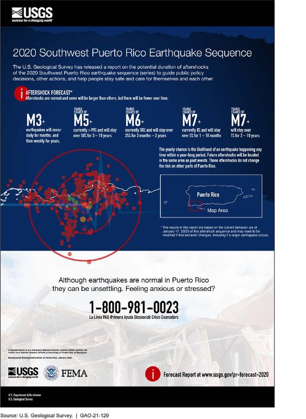
sequence in Puerto Rico that began in 2019 (see appendix II for
examples of earthquake information products USGS issues, including the
Page 18 GAO-21-129 Earthquakesaftershock forecast for the Puerto Rico sequence). 51 EHP officials
reported that since January 2020, the program has issued earthquake
situational awareness products for each of the 15 damaging earthquakes
that have occurred, deployed staff to assist FEMA emergency
management operations and the government of Puerto Rico, deployed six
temporary seismic stations to monitor aftershocks, and frequently
updated aftershock forecasts for the affected region in English and
Spanish. Additional details of these products are described below and
examples are provided in appendix II.
• ShakeMaps. Using ANSS data, USGS generates a ShakeMap after a
significant earthquake has occurred. A ShakeMap is a map of the
severity and spatial distribution of earthquake ground shaking and
provides a rapid assessment of the scale of an earthquake’s potential
impact. ShakeMaps are intended to inform, among others, response
officials and personnel, and transportation and lifeline managers
response and recovery efforts by estimating damage levels and the
scope of the needed response.
• Prompt Assessment of Global Earthquakes for Response. This
assessment estimates dollar losses and fatalities immediately after
significant earthquakes nationally and worldwide. To do this,
ShakeMap results along with data on population density, inventories
of buildings and construction types, and historical loss data, are used
to rapidly estimate the scope and impact of domestic and international
earthquakes. These estimates are generally available on USGS’s
website within 30 minutes of the earthquake and are updated as more
information becomes available. The estimates include the number of
people and names of cities exposed to each shaking intensity level,
as well as the likely ranges of fatalities and economic losses.
However, the assessment does not consider secondary effects such
as landslides, liquefaction, and tsunami in loss estimates.
• Ground failure products. The EHP issues near-real-time spatial
estimates of earthquake-triggered landslide and liquefaction (i.e.
ground failures) following significant earthquakes worldwide. This
includes maps that show areas that USGS models estimate may be
51The ANSS reports potentially damaging earthquakes to the White House; the
Departments of Defense, Homeland Security (e.g., FEMA), Transportation, Energy,
Commerce (e.g., NOAA and the National Institute of Standards and Technology),
Veterans Affairs, State, and Interior; state emergency management and response
agencies; and, the news media.
Page 19 GAO-21-129 Earthquakesaffected by ground failures, and includes estimates of the population
potentially impacted by these earthquake hazards. 52
• Aftershock forecasts. ANSS posts aftershock forecasts for
earthquakes over magnitude 5 in the U.S. and U.S. territories on its
website. It also computes forecasts for some smaller earthquakes that
are of particular public interest, such as those in densely-populated
areas. These forecasts include the expected number of smaller
aftershocks that may be felt over future time intervals of a day, a
week, a month, and a year; the probability of aftershocks large
enough to potentially do damage; and the probability of future
moderate to large earthquakes.
Assessing Earthquake Hazards and Risks. USGS publishes a suite of
earthquake hazard assessment products, including the National Seismic
Hazard Model and Urban Seismic Hazard Maps. Regarding the hazard
model, USGS quantifies earthquake hazards across the nation by
compiling all known earthquake sources (and proxies for unknown
sources), their distance from the site in question, and other seismological
and geological information. The model then projects peak ground motions
that have a specific probability (e.g., 2 percent) of being exceeded over a
particular period of time (e.g., 100 years) and produces national seismic
hazard maps. 53 National seismic hazard maps are the basis for seismic
provisions in model building codes adopted throughout the U.S. and
inform $1 trillion of infrastructure construction per year. Government
officials, emergency management, and policy makers also use the hazard
models to address local efforts and to understand and reduce seismic
risk. For example, FEMA incorporates the USGS hazard models directly
in their computer programs, such as its Hazus tool, to assess earthquake
risk to the nation and help communities prepare for earthquake shaking. 54
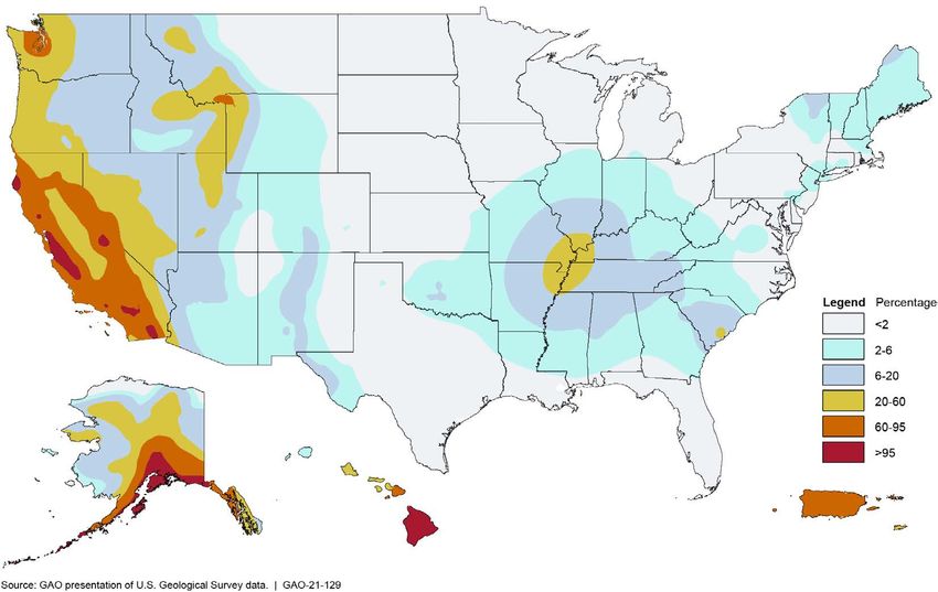
Figure 5 depicts the probability of a Modified Mercalli Intensity 6
earthquake occurring in 100 years as shown in the 2018 National Seismic
Hazard Map for the 48 contiguous states in combination with the 2007,
52According to USGS, its models provide regional estimates of landslide and liquefaction
hazard triggered by this earthquake, but do not predict specific occurrences.
53USGS also occasionally issues short-term seismic hazard maps. For example, USGS
also issued one-year seismic maps for the Central and Eastern United States from 2016
through 2018 to forecast potential shaking from both induced and natural earthquakes.
54Hazus is used for mitigation and recovery, as well as preparedness and response.
Government planners, GIS specialists, and emergency managers use Hazus to determine
losses and the most beneficial mitigation approaches to take to minimize them
Page 20 GAO-21-129 Earthquakes2003, and 1998 seismic hazard maps for Alaska, Puerto Rico, and
Hawaii, respectively.
Figure 5: Example of a U.S. Geological Survey National Seismic Hazard Map for the Probability of a Modified Mercalli Intensity
6 Earthquake in 100 Years, Expressed as a Percentage
The National Earthquake Hazards Reduction Program Reauthorization
Act of 2018 mandates the creation of a systematic set of maps of active
faults and folds, liquefaction susceptibility, susceptibility for earthquake
induced landslides, and other seismically induced hazards. 55 As of
February 2021, USGS reported it is in the initial planning stages to
develop a strategy to deliver national-scale assessments such as those
55Pub. L. No. 115-307, §3, 132 Stat. 4408, 4409.
Page 21 GAO-21-129 Earthquakesfor seismically induced liquefaction or landslides. In addition, USGS has
partnered with state and local experts to produce more detailed urban
seismic hazard maps. Some of these include additional hazard models
and maps that estimate the likelihood and severity of secondary hazards
such as earthquake-induced landslides and liquefaction. For example, to
date, USGS has conducted urban hazards studies for the San Francisco
Bay Area in California; Memphis and Shelby County in Tennessee; St.
Louis, Missouri; Evansville, Indiana, and Seattle, Washington. USGS
officials also reported ongoing seismic hazard studies for Salt Lake City,
Utah and Los Angeles, California.
Conducting and Supporting Scientific Research. The EHP conducts
targeted and broad research on the causes, characteristics, and effects of
earthquakes. The program also provides grants to support external
research on earthquake hazards. Finally, USGS, in coordination with
NOAA and the relevant states, conducts tsunami-related research such
as identifying offshore earthquake source zones that have the potential to
generate tsunamis. For example, beginning in 2018, USGS’s Coastal and
Marine Hazards and Resources Program, NOAA and the Department of
Interior’s Bureau of Ocean Energy Management are working with
academic and private partners to conduct geologic sampling research
and geophysical offshore mapping to better assess earthquake, landslide,
and tsunami hazards along the Pacific Northwest coastline. 56
Stakeholders Report that USGS officials, state geologists, and other stakeholders we interviewed
Resource Challenges stated that USGS’s efforts to identify earthquake hazards have been
impeded by limited discretionary resources for its core capabilities, such
Have Impeded USGS’s
as conducting assessments and applied scientific research. For example,
Efforts to Identify the administration requested a reduction in appropriations to the EHP in
Earthquake Hazards fiscal years 2016, and 2018 through 2021 ranging from almost $13 million
dollars for fiscal year 2018 to over $25 million dollars for fiscal year
2021. 57 In contrast, the administration requested increases in
appropriations to the program’s budget for fiscal years 2014, 2015, and
56This work began in 2018 and is expected to be completed in 2022. Academic partners
include the University of Washington, University of Hawaii, Humboldt State University,
Scripps Institution of Oceanography, and Oregon State University.
57The administration proposed cutting the EHP’s budget by about $34.4 million for fiscal
year 2019 and $20.2 million in fiscal year 2020. The administration also proposed cutting
the EHP budget by about $1.5 million in fiscal year 2016.
Page 22 GAO-21-129 EarthquakesYou can also read