URBAN FLOODS IN GUWAHATI - Review of Studies on From Flood Knowledge to Urban Action - Assam Disaster ...
←
→
Page content transcription
If your browser does not render page correctly, please read the page content below
`

              Review of Studies on
    URBAN FLOODS IN GUWAHATI
      From Flood Knowledge to Urban Action

                                             Page i of 71
`

                    July 2014

    Assam State Disaster Management Authority

                                                Page ii of 71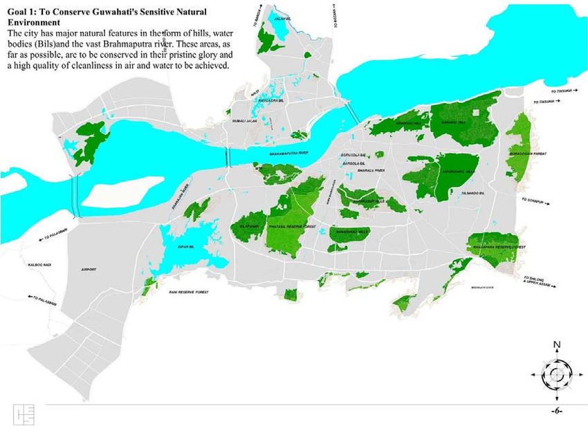
`

Title: Review of Studies on Urban Floods in Guwahati from Flood Knowledge to Urban Action

Prepared by All India Disaster Mitigation Institute (AIDMI).

Supported by Assam State Disaster Management Authority (ASDMA).

© Assam State Disaster Management Authority, July 2014

                                                                                            Page iii of 71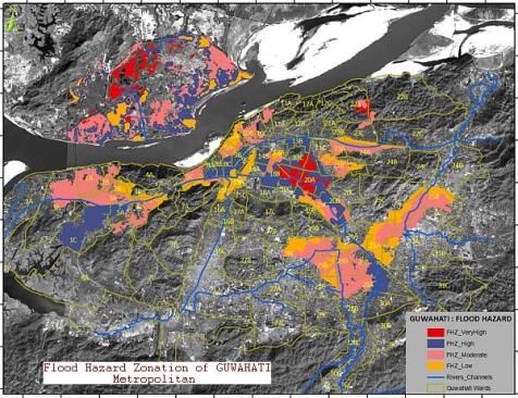
`

                                                              Contents

Acknowledgements.................................................................................................................... v
Executive Summary................................................................................................................... vi
Abbreviations ........................................................................................................................... vii

Chapter 1: About Study.............................................................................................................. 8

Chapter 2: Summary Note on Core Studies Related to Guwahati City ................................... 10

Chapter 3: Findings .................................................................................................................. 35

Chapter 4: Recommendations ................................................................................................. 42

Chapter 5: Possible Way Ahead, Risk Reduction Measures .................................................... 49

Chapter 6: Conclusion .............................................................................................................. 53

Annexure: 1 List of Documents Reviewed ............................................................................... 54
Annexure 2: Glossary ............................................................................................................... 56
Annexure 3: Hazard Vulnerability Profile of Various Municipal Wards .................................. 58

References ............................................................................................................................... 71

                                                                                                                           Page iv of 71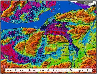
`

                                          Acknowledgements

‘The Review of Studies on Urban Floods in Guwahati: From Flood Knowledge to Urban Action’ was
conducted for ASDMA (Assam State Disaster Management Authority) by AIDMI (All India Disaster
Mitigation Institute) with the objective to carry out a review of various studies on floods that have
affected the city of Guwahati. This review seeks to understand the extent of the vulnerability of
Guwahati to floods (especially flash floods) and the nature of their varied impacts on the city. This
review will cover the disaster related risks in Guwahati and also account for the impacts of climate
change on the risk profile of the city. The review will also reflect the list of findings and suggestions
in terms of two timeframes – short and long term. The purpose of this review is to turn knowledge
into action. Thus, this is not an academic review but an action oriented one.

AIDMI would like to thank everyone whose efforts helped us to successfully conduct and finish this
review.

We sincerely thank Shri Ajay Tiwari, CEO, ASDMA for supporting the study at right time with
purpose of turning knowledge into action. We would like to express our gratitude to Ms. Nandita
Hazarika, Deputy Secretary and SPO, ASDMA for constant support and guidance to keep the study
on track. We are also thankful to ASDMA team for providing useful resources to review under the
study.

We thank Shri Dayaram Raj Bangshi, ADC (GMC); Mr. Dilip Pathak (Chief Engineer, GMDA); Dr.
Sanjay Kumar Sharma (Scientist, Centre for Flood Management Studies); Dr. Arup Kumar Sharma
(Head, Dept. Of Civil Engineering, IIT Guwahati); Mr. Anuradha Dutta (SPADE NGO); Mr. Nibaran
Barua, Head, Dept. of Design (Water resource department); Mr. Kalyan Das, PhD - Associate
Professor (Omeo Kumar Das Institute of Social Change and Development); Mr. Muktaram Deka and
Mr. Ranjan Borah (ASDMA); Mr. Kaustav Talukdar (DDMA, Kamrup –Metro; and Dr. Hariprasad
Sharma (Head, Dept. of Environmental Science, Guwahati University) for their inputs and support in
providing useful resources on Guwahati flood.

Sincere thanks to Mr. Mihir R. Bhatt, AIDMI for his guidance and inputs in the study. AIDMI team -
Mr. Aditya Jain and Mr. Vishal Pathak conducted the study; Mr. Ennio Picucci and Mr. Gautam Bhut
assisted in the identification of different studies to review under this study; Mr. Manish Patel
supported in the design of the report.

All India Disaster Mitigation Institute

July 2014

                                                                                            Page v of 71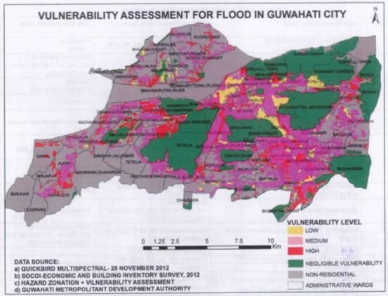
`

                                      Executive Summary

A paradigm shift in understanding the human civilization in the context of risk has opened up
avenues for getting deeper dives in the ocean of knowledge. When specific issues like that of
recurrent flash floods in Guwahati city of Assam are looked at from the perspective of constant
change in its nature and magnitude, a debatable range of causes and recommendations can be seen.
This ocean of knowledge is huge which different persons, organizations and entities have tried to
explore to give their perspectives and opinions for the ultimate solution. It was realized that this
knowledge can be of great value and will be more logical than conducting a new study for some
newer solutions. The Assam State Disaster Management Authority (ASDMA) having this broader
realization assigned the All India Disaster Mitigation Institute (AIDMI), Ahmedabad- the task of
reviewing the major studies that had been conducted so far on Guwahati flash floods and to bring the
recommendations under one logical umbrella so that unified and inclusive action can be initiated
taking into account different sectoral perspectives reflected through each study that had been
conducted and completed.

The objective of the study was to find out studies on flash floods in Guwahati with specific attention
to disaster and climate change risk related issues and to compile their findings and recommendations
under one umbrella that exhibits short term and long term actions. However, as mandated this was not
meant for academic purposes but rather for simplifying and defining unified and inclusive action
points for bringing a solution to this problem.

 The process for conducting the study started with defining the report structure, finalizing the action
plan, visiting Institutions and collecting research reports and documents, finalizing at least 25
documents to be reviewed and studied, preparing draft report based on the review and sharing with
ASDMA for comments and finalizing the report.

The structure of this report will at the outset orient the reader with background of the study with
objective, methodology and process, summary of findings of the studies reviewed, recommendations
under short term and long term implications and possible risk reduction measures. It also includes list
of the studies reviewed and other references consulted for the study along with a glossary of terms
used. The reader after going through the report may be able to synthesize the efforts made and may be
able to develop a perspective including more practical, feasible and logical regime of solution.

The overarching conclusion of this report is that multiple stakeholders will have to initiate action as
recommended and should have to work out an integrated action plan to accomplish the objective.
Such a study opens up our thinking to cover broader views cutting across sectoral perspectives and to
bring a holistic approach of dealing with larger issues like the floods in Guwahati city. It is expected
that this report will help in generating consensus among all the relevant stakeholders to work out
holistic solutions to the challenges of floods in the city of Guwahati.

                                                                                          Page vi of 71
`

                          Abbreviations

AIDMI    All India Disaster Mitigation Institute
ASDMA    Assam State Disaster Management Authority
ASDMP    Assam State Disaster Management Plan
AUWSSB   Assam Urban Water Supply and Sewerage Department
CBUD     Capacity Building for Urban Development
CDMP     City Disaster Management Pan
CWC      Central Water Commission
DDRIC    District Disaster Response and Information Centre
DEOC     District Emergency Operation Centre
DM       Disaster Management
DPR      Detailed Project Report
DRIC     Disaster Response and Information Centre
EOC      Emergency Operations Centre
ESF      Emergency Support Functions
EWS      Early Warning Systems
FCD      Flood Control Department
FLEWS    Flood Early Warning Systems
FSI      Floor Space Index
GIS      Geographic Information System
GMA      Guwahati Metropolitan Area
GMC      Guwahati Municipal Corporation
GMDA     Guwahati Metropolitan Development Authority
HRD      Human Resource Development
IPCC     International Panel on Climate Change
ISRO     Indian Space Research Organization
JNNURM   Jawahar lal Nehru National Urban Renewal Mission
MoHUPA   Ministry of Housing and Urban Poverty Alleviation
MoUD     Ministry of Urban Development
NDMG     National Disaster Management Guidelines
NESAC    North Eastern Space Applications Centre
NGOs     Non-Governmental Organizations
PHE      Public Health Engineering
PWD      Public Works Department
SDMG     State Disaster Management Guidelines
SDRF     State Disaster Response Force
SOP      Standard Operating Procedures
TandCP   Town and Country Planning
ULB      Urban Local Body
UNDP     United Nations Development Programme

                                                             Page vii of 71
`

                                   Chapter 1: About Study

1.1 Background
The city of Guwahati is located at the banks of the river Brahmaputra and several of its tributaries
pass through the city. Urban growth in the city of Guwahati has been rapid, with uncontrolled
development activities. These activities have had a detrimental impact on the ecology and
environment of the city. The city is surrounded by wet lands that under threat due to the encroachment
and unplanned urban development of the city. The city is prone to floods and landslides and is located
on the earthquake prone (zone V) belt. In addition to being vulnerable to these natural hazards, the
city of Guwahati and is frequently affected by seasonal flash floods, which are not entirely caused by
natural factors alone.

There are many sectors which are directly related with the resilience of Guwahati city against floods
and their related impacts. Following are the key sectors that should be studied to understand the risk
profile of the city for devising suitable strategies for resilience. These include, housing and urban
planning; urban infrastructure and services (water supply, sewerage, natural and storm water drainage,
solid waste management, electricity, health); informal settlements and slums; poverty and livelihood;
ecosystems and land-use; emergency response capacity.

Based on the above-mentioned situation (hazards and vulnerabilities), number of agencies
(government, humanitarian and development) several experts have conducted studies on or linked
with Guwahati and floods. These studies differ in their scope, timeframe and focus on different
aspects such as socioeconomic factors, climate change, city development plans, disaster management
planning, focus on single or multiple hazards etc.

These studies reflect useful and micro level findings that are relevant to Guwahati and the surrounding
areas. There are different studies which reflect the same findings with minor changes in the recent
development of new vulnerabilities. Instead of conducing new study, it is better to a conduct review
of studies that focus on Guwahati and floods. This serves as the rationale behind conducting this
study.

The exercise is to bring all the flood study works in one place and review the same for arriving at the
short term and long term measures for Guwahati for finding a solution to the problem related to risk
of floods in the city.

1.2 Objective
The objective of the task is to conduct a review of flood studies conducted for Guwahati which coveri
disaster risk related issues including the risk related to climate change and different vulnerabilities
that triggering the impact of floods. The review will also reflect the list of findings and suggestion in
terms of two timeframe – short and long term. The purpose is to turn knowledge into action. This is
not an academic review but an action oriented review.

                                                                                              Page 8 of 71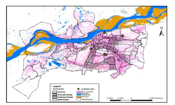
`

1.3 Process
    No.   Step                    Outputs                                     Deliverables
    1     Outline of the study    Report structure is reviewed and ready to   1. List of studied
          report                  use                                            documents
    2     Meeting with ASDMA      Plan of action                              2. Report sharing
                                                                                 findings and
    3     Visit to different      Updates in list of documents
                                                                                 suggestions with
          institutions in
                                                                                 focus on
          Guwahati
                                                                                 Guwahati and
    4     List of identified      Minimum 25 documents identified to             floods.
          studies/ report to      review (refer to Annexure 1 for list of
          review                  documents and list of reference)
    5     Draft report for        Complete draft report with findings in
          comments                two time frame – short and long term
    6     Meeting with ASDMA      Comments from ASDMA
    7     Final report            Incorporation of comments

1.4 Scope and Limitation
This study is focussed on bringing out action oriented findings from the already done planning and
research work by various sectors like govt agencies, humanitarian groups, research scholars, academic
institutes etc. The field of study was limited to recent documents and research works conducted on
floods in Guwahati City, which has now become a common scenario every monsoon season. The city
experiences severe impacts of flash floods which are triggered by inadequate civic amenities and
negligence of existing natural drain basins. Within a limited time constraint, refining the main
findings from several reports and studies was carried out addressing the key sectors which affect the
resilience capacity of Guwahati City. The recommendations are given in two time frames of short
term and long term measures covering both structural and non structural aspects of intervention.

                                                                                             Page 9 of 71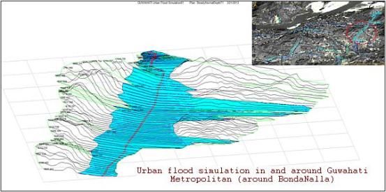
`

    Chapter 2: Summary Note on Core Studies Related to Guwahati City

2.1 Key studies
The North Eastern region of India is extremely vulnerable to natural hazards like earthquakes, floods,
landslides etc. Every year during the monsoon season, the region experiences worst fury of nature in
the form of Brahmaputra River flooding and erosion along its banks, devastating large areas of
habituated landform and damaging agrarian lands, especially Guwahati city experiences its worst
impact in theform of flash floods every year. Several studies had been done on the impacts and effects
of floods in the city and its environs. Guwahati being the largest urban centre and a hub of major
activities in the region faces most severe impacts of these floods. A compilation of reports addressing
important issues and their possible remedial solutions is provided here which can be extremely helpful
in planning for long lasting flood mitigation process in Guwahati city.

I. Flood Hazard Zonation based on GIS and remote sensing prepared by
   NESAC (North Eastern Space Application Centre)
Background: Urban flooding is one of the most recurrent hydro-meteorological disasters presently in
the world. A sizeable portion of the world’s population suffers from floods every year in major towns
and cities. Conveyance of floodwaters in wash corridors and arroyo floodplains that were once
predominantly overland sheet flow or flow in rills and gullies, are now obstructed by houses, fences,
small buildings, streets, and other obstructions inhibiting their free flow . Guwahati city situated in the
north-astern state of Assam is fast becoming one such victim of flash floods that occur due to
unplanned growth. Traditional one-dimensional backwater models are inadequate to predict the
unconfined flow behaviour in such urban environments like Guwahati and if used, require too many
assumptions regarding flow diversions and potential confinement. Two-dimensional flood routing
programs can efficiently simulate these complex urban flood environments with accuracy and detail.

                                        Image 5. Guwahati city and its environs, Source: http://nesac.gov.in

Flood hazard mapping and flood inundation modelling are the vital components in flood mitigation
measures and land use planning, and are prerequisites for the flood insurance schemes. As flood itself
cannot be prevented but the damages due to floods can be mitigated with proper planning and
preparedness at community level. For that it is very important to identify the degree of hazard

                                                                                               Page 10 of 71
`
associated with various portions of a flood plain. Hence flood hazard zonation is an important
component of overall flood management strategy1.
Database used to conclude on the findings were:
Hydro-Meteorological Data:
Rainfall data (hourly, daily) for last 25 years.
Daily discharge and water level data of rivers and major sewer-storm / drainage channels
flowing in the study AOIs.
Sewer and drainage layout map and plans of Guwahati.
Cross-section and Longitudinal profiles of rivers and major drainage / sewer channels.
Spatial And Ancillary Data:
Municipal Sewer-Storm / Drainage system map from respective departments for Guwahati.
Flood Inundation reports/maps.
Municipal Sewer-Storm / Drainage system map from respective departments for Guwahati.
Municipal Wards and Town Layout.
Image 6. Base flood elevation for Guwahati City, Source: http://nesac.gov.in
1
Hazard Risk Vulnerability Assessment of Guwahati. ASDMA report. Technical Report and Atlas on remote sensing and
GIS based inputs for hazard risk vulnerability assessment of Guwahati city ,http://nesac.gov.in
Page 11 of 71`
Image 7. Urban Flood simulation in and around Guwahati metropolitan Area, Source: http://nesac.gov.in
Hydrologic-Hydraulic Analysis and Modelling:
The rainfall data analysis showed that there are storms and surges in the annual intensity-duration-
frequency (IDF) trend in the last 10 years. Monthly total rainfall peaks ranged between 200 mm and
400 mm in the last 10 years. These rainfall storm events have induced flood inundation and water
logging in parcels of Guwahati metropolitan. The analysis of the monthly rainfall data showed that the
average annual rainfall is about 2355mm and out of this about 22% of the annual precipitation occurs
in April and May and about 65% of the precipitation occurs in the period of June, July, August and
September. However, it can be predicted that the rainfall intensity has a direct relation with the
induced surface overland flow and drainage discharge capacities (over that it was already conveying
prior to the storm event).
Image 8. Flood Hazard Zonation of Guwahati, Source: http://nesac.gov.in
Page 12 of 71`
All the findings from these geographical assessments have been translated in to following graphical
representation using GIS based platform to disseminate the information for easier interpretation.
Image 9. Vulnerability Assessment for flood in Guwahati City, Source: report and atlas on GIS based inputs, NESAC
V.High
High
Medium
Low
Least affected
Image 10. Statistical representation of Flood Hazard Zone, Source: report and atlas on GIS based inputs, NESAC
Page 13 of 71`
2. Comprehensive plan for management of drainage congestion problem of
Guwahati (Water Resource Department)
The drainage system of Guwahati city depends heavily on the existing natural drains. The conditions
of these channels are not very convincing as they are constantly covered with garbage, waste material
and sewage. The water resource department had prepared a comprehensive plan for the clearing and
management of these drain channels, which are like a lifeline of Guwahati City for the purpose of
draining out water currently. The city doesn’t have planned drainage system to take care of sewage or
waste water which is being generated, so these natural channels become all the more important. The
existing drain system of the city consists of:
Bharalu Basin (catchment area=100 sq. km)
Silsako Beel Basin (Catchment area = 92 sq. Km)
Deepar Beel Basin(Catchment area= 144 sq.km)
Kalmoni Basin (Catchment area= 66.5 sq.km)
Fore shore Basin
The existing natural drain channels are:
i. Bharalu-Bahini river system
ii. Mora Bharalu River
iii. River Basistha
iv. Lakhimijan Channel
v. Bondajan Channel
vi. Khanajan River
vii. Kalmoni River
During monsoon season, the river Brahmaputra flows over the danger level and the low lying areas of
Guwahati City face problems of water logging and floods. The feeder drains to the main channels run
overflowing, and because of siltation problem of drains, the carrying capacity is also reduced
significantly. The water resource department in response to these existing problems took some
effective remedial measures like construction of flood walls, installation of high capacity pumps in
low lying areas, providing sluice gates on the channels to control flow of water and other significant
measures. Some more proposed interventions are under way, which will address the existing flooding
problem like re-sectioning of existing channels, construction of storm water drains to carry off
excessive flow into the main channels, clearing the existing channels from waste disposal and
restricting the drop of sewer in those channels.
The remedial recommendations are provided at several levels covering structural and non-structural
aspects. The proposed structural measures include: Inter basin transfer of load, so that in case of
excessive flow in one channel, the flow can be directed to other river with lesser load. The capacity of
existing drain channels need to be increased as the amount of excessive water coming to them will be
beyond the handling capacity of these channels currently. Defining the sections of existing channels,
so that the problem of encroachment over them and the waste disposal in them can be checked.
There are a number of sub projects listed within the entire flood management plan.
i) Bahini Bondajan Flood Water Evacuation Project- the main features of this project are-
Construction of RCC drain of length 700 metre from Rukminigaon to VIP road.
Re-sectioning of VIP roadside drain to a capacity of 15Cumec discharge upto Silsako Beel
and Re-sectioning of existing channel from Silsako Beel to Bondajan sluice gate
Construction of additional sluice gate at Bonda having five shutter opening to arrive at
combined capacity of 80 cumec discharge.
Installation of high capacity pumping station at Bondajan to facilitate dewatering when the
sluice gate is closed
ii) Providing of Pumping Stations at different locations to relieve drainage congestion
Renovation of Bharalmukh pumping station by installing 6 nos. Of new high discharge pump
Page 14 of 71`
Installation of high capacity pumps to throw discharge of khanajan during closure of
Khanajan sluice.
Procurement and installation of trolley mounted pump sets for dewatering of storm water at
water logged areas of Guwahati City.
iii) Defining boundaries of the natural channels
Construction of flood walls on both bank of river Morabharalu.
Construction of flood walls on both banks of river Bahini.
Construction of flood walls along both banks of river Bharalu.
Re-sectioning of Pamohi channel from Mora Bharalu outfall point at N.H. to Deepor Beel.
iv) Improvement of sluice gate over Kalbhog channel with proper pumping facilities including flood
walls along both bank of Kalbhog channel from Kalbhog sluice to its outfall (for augmentation of
flood at LGBI Airport and its adjoining areas.
Constructon of new channel from backside of new terminal of LGBI Airport to Kalbhog
channel and from Kalbhog channel to existing drainage channel at Dakhala and then Kuldung
to end of Dora Beel towards river Kulsi.
Construction of new channel from Batahi bridge near Dekapara towards Padma lake to
Kalbhog channel to meet the main drainage channel as mentioned above.
Improvement of existing drainage channel from Dakhala to Dora Beel which has its outflow
to the river Kulsi.
Improvement of Kalbhog channel and also the channel coming from Dharapur through new
terminal towards Agchia.
Construction of Hume pipe sluice at suitable location to drain the run-off from sub-catchment
area of surrounding areas.
v) Some Administrative measures
Strict ban on earth cutting in hill areas surrounding the city.
Stop encroachments in the hill areas, wetlands and drainage channels of the city.
Strict ban on garbage dumping on wetlands and drainage channels.
Fixation of road levels
Preservation of all existing water bodies/swamps in the city area.
All these measures are bound to bring about a better flood management system for the city. The
proposed interventions will help in fighting the problem of water logging and inundation on the low
lying areas.
Page 15 of 71`
3. Guwahati Flood Mitigation Project, ASDMA
Table No. 3
No Description Actions Agencies Time frame Cost
. responsible
1. Drains 1. De-siltation, 1. GMC would De-siltation, 20 Crores
Deposition of silt in cleaning, carry out the cleaning, and
primary and fencing, de-siltation and fencing to be
secondary drains, lining of all cleaning, over by April’
clogging due to drains 2. DC would 2012
garbage, open drains 2. Strict carry out the
a risk penalties for Lining and
indiscriminat fencing through
e garbage the line
disposal in departments
drains etc.
2. Waterbodies 1. Immediate 1. DC would Bondajan/Sorsola 100
Encroachment/fillin Eviction, carry out the , Borsola and Crores
g up of 5 major demarcation, task through Silsako to be
water bodies excavation, ATDC and done taken up in
adversely impacting fencing, and GMDA the next two
the water retention 2. Medium to 2. Government to years. In the next
capacity of these long term notify rules 5 years
major Beels. Rules activity: immediately development of
under the beautificatio Deepor Beel can
Waterbodies n be taken up.
preservation act not 3. Rules to be
yet notified. notified
3. Early warning Early flood GMC with the 1 Year 20 Crores
Public largely warning systems help of IMD
caught unawares by to be installed would take the
floods initiative forward
4. Rain water No percolation 1. GMC+GMDA 2 months NIL
harvesting of water to notify it in
Large run offs Different forms the bye-laws
leading to flash of RWH to be 2. PWD may
floods made mandatory look into
in all buildings; appropriate
technology for technologies
increasing for reducing
absorption by surface run
ground to be offs
explored
5. Plastic menace Restrictions to PCB + GMC will 3-6 months NIL
Plastic is becoming be imposed in take necessary
a hazard Guwahati city in steps to notify and
manufacturing enforce
and use of
plastic
Page 16 of 71`
6. Save the hills 1. Hill cutting 1. Divisional 3-6 months 15 Crores
Hill cutting and (prohibition Commissioner
encroachment leads act) may be , LAD and
to flow of soil into reviewed DC, Metro
the drains and strictly 2. DFO may be
implemente asked to carry
d out plantations
2. Tree/Vetiver drives in all
plantation hills. An
amount of Rs.
1 crore per hill
may be placed
with DC
7. Pump sets Procurement of WR 3 months 10 Crores
Pump sets pump sets
insufficient to drain
out water from the
low lying areas
8. Road levels Fixation of PWD in 3 months NIL
Gradual rise of the uniform road consultation with
road levels leading levels across GDD
to flooding in Guwahati
residential areas depending upon
the different
zones
9. Storm water drains A storm water GDD 1-2 years Estimatio
Absence of storm drainage n need to
water drainage network to be be done
network and No put in place, based on
channels for excess along with GIS TAHAL
water to flow out mapping of all DPR
drains in
Guwahati City
10. DDMA 1. State of the DC + DMC 3 months 2 Crores
Knee jerk response art DDMA
without and UFC to
departmental be made
coordination active in the
DC office
2. Institutional
framework
to be
worked out
3. Standard
SOP to be
put in place
11. Peoples Mock drills, DM Under DC, Over the next 6 2 Crores
participation audit, activities can be months
People lack Awareness organized
awareness generation,
Capacity
Building and
training,
Documentation
Page 17 of 71`
4. Master Plan for Guwahati Metropolitan Area‐ 2025
The recommendations from CDP are translated into action oriented proposals through Master Plan for
the Guwahati City. The foremost priority of Master Plan is to regulate the landuse Zoning and keep it
revising according to changing requirements. The document presents extensive planning processes
regarding all the key areas discussed for long term benefits to the residents. The main goals of the
Master Plan are-
To conserve Guwahati’s Sensitive Natural Environment
To develop an integrated intra-urban Transport System.
To develop Well-Distributed Physical and Social Infrastructure
To provide Space for Efficient Functioning of Economic Activites
To create special provisions for the state capital requirements
To create affordable housing for all and develop a city without slums
Image no. 11 : Map of Guwahati city showing wetlands and forest areas
The economic sector is the main anchor behind the progress and growth of any city region. Guwahati
has become one of the major hubs of economic activity in the entire North-East India. The
establishment of Guwahati Refinery in 1962 marked the beginning of industrialization in the city. The
construction of bridge over River Brahmaputra at Saraighat and the shifting of capital from Shillong
to Guwahati in 1972 made tremendous economic impact on the city and turned Guwahati into one of
the most important cities in the North-East. The economic development alongside require
strengthening of infrastructure and other basic requirements like transportation, drainage, roads, water
supply, health, housing etc. The emphasis had been laid on decongesting the core city area and
developing satellite towns with high class infrastructure services to them. The main areas of
improvement for the city of Guwahati are enlisted with brief description below.
i. Socio-economic scenario of the city- This section looks deep into the economic activities
which run the city and their interrelation with people working within those domains.
Composition of work force, market areas, major goods of trading, existing trading structure,
Page 18 of 71`
retail sector, upcoming major business hubs, small scale district and neighbourhood market
place and all those aspects which are related to economic growth of Guwahati.
ii. Transport- One very important developmental issue for this city is its existing transport
infrastructure. Lot of people from nearby towns and villages come to Guwahati every day,
some as daily wagers, some for job, and some to find new prospects in urban living. All these
flocking crowd needs to be provided ample transport facilities intercity as well as intra city.
The development plan addresses this issue by taking a detailed analysis of current scenario,
and having future projections based on it. Traffic volume analysis, household requirements,
employment pattern, condition of roads, demand for new transport system have been all
studied in detail to come up with viable solutions.
iii. Physical Infrastructure – The infrastructure facilities becomes the most important area of
improvement as it directly affects residents of city every day. Water supply, sewerage,
drainage, solid waste management, power supply, etc are studied in context of their present
situation and the requirements of increasing capacities with increasing population.
iv. Social Infrastructure- The various components of social infrastructure like schools,
recreational spaces, hospitals, security services, emergency response, and communication
services like post and telecommunication are also analysed to stay up to date with increasing
demands. The new satellite townships will be key solutions to the existing problems to the
city, as it is planned to ease the stress on major core zones of the city.
v. Housing and Slums- The increasing population demands safe and affordable housing
options. The Development Plan is especially concerned for this problem and the expansion of
new satellite towns is being undertaken in lieu of this problem. The different sections of
society require different housing needs and thus the development model can be devised to
cater everyone’s need. Increasing migratory population too require place to cover their heads,
and slums can’t be totally removed because of this reason. The slum population have to be
considered as an integral part of city and development process is required to address the needs
of them too.
Image no. 12: Map of Guwahati city showing slum areas and proposed areas for housing development
Page 19 of 71`
Image no. 13: Map of Guwahati City shwing proposed development schemes
The proposed landuse zoning addresses all these issues and proposes viable solutions for a sustainable
growth of the city. Key highlights of the Master Plan 2025 are presented below:
66 sq km of new area to be added into GMA, making the total area equivalent to 328 sq km.
This will involve development of 3 new townships of area 14, 23 and 19 sq km respectively.
Key thrust area is developing transport systems which enable inter and intra region economic
development.
Heavy focus on developing a water supply, sewerage and drainage network.
Emphasis was also been given on developing the existing characteristics of Guwahati as a
ecological city with development of tourism and recreation spaces.
The development process takes long term efforts and extensive planning across all sectors to provide
the desirous results. Master plan of Guwahati City presents a holistic approach towards issues related
to urban agglomeration. All the above mentioned goals are addressed keeping in mind the projected
growth of the city, also making the approach disaster resilient is given due importance in the process.
5. Flood Management Measures and Future Vision in Assam (Water
Resource Dept., Govt. of Assam)
This document consisted of a presentation by Water Resource Department regarding the current
ongoing measures and future visions in association with flood management in Assam and Guwahati
city. The geological conditions of Brahmaputra valley creates a unique riverine system that is
beneficial for the region and equally devastating in times of monsoon rains, creating havoc especially
for the capital city situated on the banks of Bhrahmaputra River. Main reasons for floods and reasons
are
Physiographic condition of the valley
Narrow elongated U-shaped valley opening towards the Bay of Bengal branch of approaching
Monsoons
Page 20 of 71`
Average Width Valley : 80 to 90 Km, River : 6 to 10 Km
Bed Slope Int. Border to Kobo: 1 in 2390 Kobo to Dhubri: 1 in 6990
Discharge at Pandu Max: 72,794 cumes (1962), Min: 2,300 cumes (Jan/Feb)
Drainage congestion
High stages of the Brahmaputra River over prolonged periods obstruct free discharge of
tributaries causing back flow and congestion near outfalls.
Restricted waterway of road and railway bridges and culverts obstruct the natural flow of
water.
Inadequate countryside drainage through sluices in embankment system particularly during
high floods causes prolonged inundation in the countryside.
Encroachment of natural drainages further aggravates the situation.
Geology and Geomorphology
Lesser Himalayas comprise of relatively younger rock formations and are in the process of
building up. Friable in nature and easily erodible and prone to landslides.
A very young river. Its present configuration took shape only during the Pleistocene and
recent times
Excessive rainfall
Excessive rainfall concentrated during the monsoon months from May to October
Mean annual rainfall over the catchments area in India is around 2300 mm
Mean annual rainfall varies between 2480 mm in the Brahmaputra valley to 6350 mm in
North Eastern Hills.
Seismicity and Landslides
Brahmaputra Valley is subjected to frequent tectonic activity. The valley falls under Zone V,
which is highly risk zone.
Frequent tectonic activity causes geo morphological changes and landslides.
Excessive sediment charge causes rivers ton change course frequently.
Carrying capacity is reduced thereby river either spills its banks or erodes.
Formation of braided channels and constant shifting of channels and sand shoals.
Encroachment of Riverine Areas
Narrowness of the valley and restricted availability of plain areas for habitation.
Increase in population and developmental activities leading to encroachment of chars.
Density of population in plain areas more than 200 persons per sq km.
Other factors
Deforestation and improper land use due to the practice of shifting or Jhum cultivation in the
hill tracts and grazing
Laterals southward shift of the river causing migration of bank line through erosion.
Fanning out effect at Nodal points causing instability and erosion.
There have been great losses due to floods in past few decades. Total area which is under effect of
floods is around 31.60 Lha, and average area affected in a year is about 9.31 Lha. Since 1954 total
area eroded by floods is 386,000 Ha. that comes to be 8,000 Ha./Year. Total number of villages
washed away were 2534 and expected families affected were 90,700. These numbers give a brief idea
about the brutal impacts of floods in Assam.
Strategies adopted by Water Resource Dept. For flood Management can be categorised as Immediate
and short time measures that are implied on entire Brahmaputra basin and with special provisions for
Guwahati city:
Flow Confinement By Embankments
Page 21 of 71`
Anti Erosion Measures and River Training Works
Pro-Siltation Devices
Sluices
Drainage Development Works
And long Term Measures:
Creation of reservoir in the upper reaches.
Task Force constituted by Govt. of India also equivocally opined for implementation of such
multipurpose projects for ensuring flood moderation benefits.
Image no. 14 :Map of Brahmaputra River Basin showing flood embankment projects
The Hon’ble Prime Minister during his visit to Assam on Nov 2004 announced establishing a
cohesive, autonomous, self contained entity called North East Water Resources Authority
(NEWRA).
The formation of the NEWRA is in advance stage and active consideration of Govt. of India.
This Authority will go a long way in proper utilization and harnessing water resources of the
entire North Eastern region and will help in speedier implementation of the plans and
programmes so envisaged.
Hon’ble Prime Minister further reiterated during the conference of Irrigation Ministers’ at
New Delhi on Nov 2005 the need for the creation of NEWRA for fostering the developmental
process in N. E. Region.
6. Capacity Building for Urban Development (CRISIL)
In order to get better output results under JNNURM projects the MoUD (Ministry of Urban
Development) and MoHUPA (Ministry of Housing and Urban Poverty Alleviation) introduced a new
project for capacity building of Urban Development. The projects basically have three major
components:
Page 22 of 71`
Capacity building for strengthened Urban Management- This component is aligned with the
infrastructure and governance sub-mission of JNNURM and will thus support technical
assistance across the several urban management topics.
Capacities building for effective urban poverty monitoring and alleviation.- These capacity
building initiatives are aligned with the basic services to the urban poor sub-mission. They
reflect the need for building information systems, sharing experiences, and designing
strategies on urban poverty alleviation
Implementation support- This component will support a national Project Management Unit
(PMU) for providing overall technical and managerial support during the implementation of
the Programme. The PMU will have a critical role in promoting and support the project.
A rapid baseline assessment was carried out in Guwahati along with 29 other cities to monitor the
progress in the cities under CBUD programme. The main objective of carrying out this assessment
was to identify the existing status of ULBs participating in the program, and to provide necessary
assistance to the ULBs under the identified gaps.
The main areas of assessment were:
1. Municipal Financial Management;
2. Municipal Governance;
3. Urban Planning and Land use; and
4. Urban Service Delivery.
Key findings:
Municipal financial management
Asset management system needs to be strengthened.
Creating an enabling environment for improving property tax collection with political
consensus and bureaucratic will. The new councillors who will join GMC needs to be trained
at the onset regarding the crucial link between levy property tax as a source of revenue to
initiate more developmental works. This will help reduce high degree of public resistance
existing with regards to property tax and help in smoother introduction of Unit Area Method.
Improvement in revenue coverage (70%) and collection performance (50%), both require
adequate attention
Expenditures exhibit higher growth rate then revenues indicating revenue deficit in future.
Own sources of revenue are only 39% of revenue income, indicating dependency on grants.
Collection efficiency in Property tax collection pegged at 40% requires scaling up through
various set of measures.
Urban Governance
There is a need for undertaking an assessment of the existing institutional structure for urban
governance in Guwahati to assess gaps, overlaps and duplication of function between various
organizations.
There is a need for undertaking an institutional development study of GMC to assess the
manpower and skill requirement keeping in mind the role that GMC will play in the future
when all 12th schedule functions are transferred and handholding support from various
agencies (ADB, JNNURM) ends.
Fill all sanctioned posts in GMC with updated job descriptions to ensure that computer
literacy is in-built in new recruitment.
GMC also needs to review its office structure and assess the need for an integrated office
complex for improving overall management efficiency.
Page 23 of 71`
Urban Planning
Urban planning functions have been partially transferred from GMDA to GMC. However on
a day to day basis GMDA is largely responsible for urban planning including Master
Planning.
Division of city area in various ways like – GMC area, GMA area, GMDA area by the
different governance institutions create disconnect in cohesive planning of a city as a whole.
Projects are conceptualized as per a specific area by the respective agency, which in the long
run leads to inequitable development in city pockets. All efforts/projects/plans/funding
should be planned for an entire planning area, which covers agglomeration and stretches to
semi-urban areas, which will eventually be added to the city with growing urbanization to
ensure that an economic hub is created in the form a megacity that can fuel regional
development.
Although most of the above reforms have been indicated as achieved but there
implementation and enforcement needs to be stepped up. Building permissions are currently
given by both GMDA and GMC dually. Such jurisdictional overlaps in delivering urban
planning function needs to be streamlined.
Urban Service Delivery
For SWM, in order to make the PPP model sustainable it is crucial that the short-sightedness
of the original DPR in terms of household projection is rectified to increase coverage to the
actual number of households existing in the city. A proposal has also been submitted by
Ramky to GMC in November 2011 to increase the number of households in their purview.
GDD has constituted a committee to review the feasibility, however decision has been
pending.
Although capital investment needs are currently being met through central government and
multilateral agencies, but the state government needs to develop a financial institution which
can help access market funding in the future.
Integrated project management is highly required as the city is being upgraded on all fronts.
Projects for water supply, sewerage, drainage, roads, and transportation need to converge to
reduce public inconvenience. An institutional mechanism needs to be developed which brings
all agencies on a common platform such that overlaps, departmental delays, duplication is
reduced and faster delivery of projects is ensured with maximum synergy.
Technically competent people from various departments need to be assigned on the projects
while ensuring their commitment through the entire life-cycle of the project such that in-
house capacities are built in the long run.
The status of all the services provided under various departments were scrutinized to identify gaps in
the planning and delivery of services, further recommendations were also provided to improve upon
the shortcomings. The assessments done under CBUD helps in revising planning approach under CDP
and Master Plan and helps in improving the target goals
7. Climate Proofing Guwahati City, TERI, ACCRN
Background: The following study was carried out on an extensive scale under ACCCRN (Asian
Cities Climate Change Resilience Network) by TERI (The Energy and Resource Institute) to prepare
Climate Resilience Strategy for Guwahati city. TERI carried out risk and vulnerability assessment for
the city and prepared a detailed resilience strategy. Analysis of land use imageries for Guwahati city
indicates increase in the built-up area and decrease in the dense forest area. The reduction in green
cover increases the vulnerability of the city towards hazards like flooding and landslides, and also
impacts the ambient micro-climate of an area. The individual consultations revealed that water supply
is greatly hampered in the city during the flood event. Besides this, the overall lack of drainage,
absence of solid waste management system and pollution of surface water bodies and ground water
sources has created a vicious cycle that leads to flooding and water logging in the city every year.
Cutting of hills for encroachment, constructing buildings and large scale deforestation in the city has
Page 24 of 71`
led to blockage of drainage channels, destruction of top soil and high rate of soils erosion on the
exposed hill slopes. The functioning of city is heavily dependent on several key sectors, which
address different needs and requirements of its residents.
Methodology: The focus of this assessment is to facilitate adaptation initiatives and mainstream them
into the city development paradigm to make Guwahati city more resilient and prepared towards the
risks. This risk assessment largely extracted local information in the form of secondary data along
with consultations with the Government Departments and relevant stakeholders. Besides this a climate
scenario assessment was also carried out by TERI to understand the future implications of climate
change on the city. Review of existing policies and governance framework of the city was an integral
part of the assessment to identify channels for integrating adaptation and disaster risk reduction
measures in planning and development.
Current and future risk profile of the city: The information generated on vulnerable hotspots,
communities and urban functions helped in generating the current risk profile of the city. This
combined with the future climate projections provided a snapshot of the likely future risk profile of
Guwahati. The results of the risk assessment were also shared and consulted with the relevant
stakeholders to address any gaps.
Identification of adaptation and resilience options to address the risks: The current and future
risk profile of the city assisted in recognizing adaptation and resilience options to address these risks.
The objective was to have a set of adaptation options which address the vulnerabilities of different
sectors and communities and can help in making the city more resilient.
Review of existing policies and legislations to identify gaps in addressing to risks: Understanding
the current institutional mechanisms to address the risks and disasters faced by the city is an important
component of risk assessment. An integral step of the risk assessment was a review of existing
policies, legislations and by-laws to address disaster risk reduction. This review helped in identifying
the gaps in the existing policy regime to address the current and future risks.
Identification of means of integrating and mainstreaming policies for risk reduction in the
existing policy framework: The overall analysis helped in identifying means to address the gaps in
policy framework and legislations. The results are expected to make the city more resilient towards
current and future potential risks.
8. Flood zone mapping of Guwahati Municipal Corporation area using GIS
technology. Plabita Barman and ²Dulal C. Goswami
Background: GIS is fast becoming an important tool in disaster mitigation process. In a GIS,
information of geographic features objects is organized into layers such as drainage, slope, buildings,
roads, railways, and so on. The data layers on flood hazards helps in modelling for proper
management and land use practices. The research study here presents the use of GIS based
information system that can be used to prepare a flood zoning map, so that the decision makers can
have a strong base to plan for both structural and non-structural measures for flood mitigation. GIS
can integrate spatial data with non-spatial attributes and the data layers of flood zones help in
modelling for proper management and land utilization practices and proper designing of storm water
discharge system based on topography of the city. The climate of the area is sub tropical humid type
with average annual rainfall of 1766 mm and 147 average rainy days. Guwahati is a flood prone area.
The Brahmaputra River, at Guwahati station has danger level of 49.68m above m.s.l.
Page 25 of 71`
Image 15. Flood Zone Map of Guwahati City (ward wise), source: Flood zone mapping of Guwahati Municipal
Corporation area using GIS technology.pdf
Methodology:Primary data was collected from field survey using questionnaire specially designed for
the study. Data was collected from various Govt. departments and the resultant information was
transferrred on to a Guwahati City ward map using GIS platform. The results obtained after analysis
of the data are presented in the form of GIS based maps and data tables. Analysis of data from field
observations and secondary sources were done keeping in view of the natural drainage systems and
their discharge capacities, artificial drainage network for storm water discharge, pattern of rainfall and
the slope of the city.
Findings: The following zones were quantified during the period of study (See Image No 15)
1. Chronically inundated zone
2. Occasionally inundated zone
3. Rarely inundated zone
4. Inundation free zone
The study shows that 52.34 percent of the Guwahati Municipal Area is flood prone. Of this, 16.27
percent belongs to the chronically inundated category, 13.34 percent to the occasionally inundated
category and 22.73 percent to the rarely inundated category.
The main factors identified for such a high level of flood risks were the undulating topography of city
with plain area in the middle of city making it prone to flooding, encroachment on natural drain
channels and wetlands, lack of proper drainage system and solid waste disposal in the drains and
wetlands.
The major roads and areas severely affected from flood inundation problem were identified based on
field observation and can be listed as follows:
1) Geetanagar / Hatigaon Chariali upto Narengi
2) G.N.B Road from Guwahati Club to Noonmati ( Except New Guwahati Area )
3) R.G Baruah Road
4) Maligaon / Durgasarobar
5) Guwahati College approach road
6) Nabagraha Road and its nearby areas
7) Along the Kanwachal road , particularly the southern part
8) Nabin Nagar / Anil Nagar /Ambikagiri Nagar / Tarun Nagar /Lachit Nagar upto Bhangagarh
Page 26 of 71`
9) Srimantapur
10) Christianbasti area of G.S Road
11) Rukminigaon , Mathura Nagar and some low-lying area in Beltola
12) Some areas on the A.T Road
13) Santipur – Bharalumukh area
14) Fatasil Ambari
15) B.Baruah Road
16) Hedayatpur
17) Lamb Road , Ambari
18) Gandhibasti area
19) B.K Kakoti Road
20) Kachari Garigaon
The study here provides an efficient and cost effective methodology to delineate flood hazard zones in
the GMC area. The study has also focused on the identification of factors controlling flood hazard in
the study area. Such efforts should be a part of non-structural measures of flood management. The
methodology used for this study represents a new prospect for generating inexpensive, easily read,
rapidly-accessible charts and maps of inundation and waterlogged prone areas based on the
morphological, topographical, drainage basin, demographical related data of the area, that can come
very useful and handy for concerned authorities to make the planning process more result oriented.
9. Degradation of Natural Resources and its Impact on Environment: A
study in Guwahati City, Lakhimi Gogoi
Background: Like the previously discussed research on urban rural migration, this is another
perspective towards rapid and unplanned urbanisation. Guwahati city is always having very high
vulnerability towards impacts of unplanned urbanisation. The city has been faced lots of problems
which impact on the degradation of environment and poses as a threat to the biodiversity. The
popping up of multi-storied structures, encroachment on hill sides and wetlands, improper solid waste
management had only made the city’s environment worsen. From the earlier study we come to know
about the pattern of rural urban migration in context of Guwahati City. Due to rapid growth of
population, transport network, trade and commerce and industrial activities, the flow of labour group
of people to the city is increasing tremendously. Their homes are not confined only to existing
residential areas. They encroach upon areas not suitable for habitation like hill slopes, swamps,
wetlands, sides of railway tracks and river edges. Growth of settlement in ecologically sensitive areas
leads to loss of vegetation cover, biodiversity, soil los, landslides, floods etc.
Findings: Present study revealed that the population in the city has been rapidly increased after the
shifting of capital from Shillong to Guwahati. Due to rapid population growth and urbanization,
Illegal settlements, industries and excessive growth of invasive species the natural resources has been
degrading gradually. As a result hills and wetlands are encroached. Hence, with a depleting green
cover on the hill tops and hill slopes, shrinking wetlands and low lying areas due to human
interference and encroachment, the environment in the city is witnessing and experiencing
unprecedented pollution (Deka et al, 2011).Wetlands and hillocks of Guwahati have taken the
maximum battering because of rapid urbanisation. Wetlands recharge ground water and serve as
storm water deposits, they also influence a regions micro-climate. Due to waste water and garbage
being dumped in these sensitive areas, the quality of water had degraded, and the drainage capacity
had also decreased. As all these natural reservoirs of water are being encroached and filled up as a
result flood has become a regular phenomenon in the city leading to an unhealthy situation. The
natural environment is progressively destroyed for unplanned construction of buildings and roads,
release of industrial wastes to the drainage channels, stagnation of filthy water in the intermittently
unfilled depressions, which become the breeding place of mosquitoes, etc. have created serious
problem of natural resource degradation and environmental pollution, endangering the health of civic
life of Guwahati. Guwahati’s maximum progress in last two decades have came up on the on the areas
covering up wetlands. Lot of construction have taken place on the wetlands. The large number of
Page 27 of 71`
wetlands that Guwahati once had is now being reduced to fragmented forms. As the natural reservoirs
and wetlands are being encroached upon, as a result floods have become a regular phenomenon in the
city. Loss of forest cover is an important contributing factor to the occurrence of land slide in the city
in recent years. Flash floods, water logging and dust pollution have aggravated in the area due to the
deforestation and earth-cutting in the foothills. Moreover improper disposal of Municipal Solid Waste
clog the drains of the city and in rainy season artificial floods are occur. The twin man-made factor
creates flash flood in Guwahati city.
Recommendations: To protect the natural resources from habitat loss, fragmentation and alteration
the following recommendations were given
Regular monitoring of the wetland and hill using various modern techniques,
Continuous environmental awareness program among local people.
Alternative livelihood options to those depended upon the Beel.
Proper enforcement of the policies.
Afforestation around the barren area.
Minimize the encroachment around the Beel and hill area. Unauthorized encroaches are to be
evicted from vulnerable points for which strict legislative control will be necessary.
10. Present scenario of solid waste with special reference to plastic and
other non‐biodegradable solid waste and its management for the
sustainable urban poor development in Guwahati city, Assam, India
Background: In the context of ongoing study related to occurrence and of floods and reason for its
redundancy in Guwahati City, this study analyzes another major factor, i.e. generation of solid waste
and its handling in the city. A scientific study was carried out in 12 different localities of Guwahati
city covering more than 0.21 million population. The study includes on generation of solid waste and
the type of plastic waste consisting of various recyclable and non-recyclable plastics and possible
suggestive measure on plastic waste management and sustainable urban poor development are also
discussed. In the present scenario only 10% plastic is being collected for recycling where as glass and
metal is 50% and 70% respectively with 559 numbers of waste collecting points by 15000 numbers of
waste collectors and rag pickers in the studied localities of the city. It was found that among the
plastic waste generated from household 60% are of Recyclable Plastic (RP) and 40% are Non
Recyclable Plastic (NRP) according to the present scenario. The plastic waste has been playing a
major role in clogging of drains and artificial water logging.
Methodology: Random samples were collected as per the variation of waste generation. Wet samples
were air dried to remove the water content and the samples collected from different sources were
averaged out to give a per capita number. Samples were collected from ten wards of the city (51 to
60) . The study recyclable solid waste was conducted at 12 sites and information was collected from
rag-pickers with the help of a prepared questionnaire. It is estimated that around 1500 rag-pickers are
operating at land fill site at Pachim Boragaon. The small dump houses do cleaning and segregation of
waste into different categories like plastics (bottles, carry bags, different pouch packs, CD and
electronic waste, large articles like chair and table etc.), glass (broken glass and bottles), metal(tin,
iron, aluminium), paper (news paper, cartons, hard board), rubber, etc. This separated material is then
sold off to larger recycling industries.
Findings: During the study, various solid waste types are collected and differentiated as
biodegradable, plastic, glass and metal waste and accordingly compiled the total generation; which is
contributing as 57%, 1%, 14% and 28% respectably in the total waste generation scenario Solid Waste
management in Guwahati City. In Guwahati, all the plastics, i.e. both recyclable and non recyclable
are being dumped together at different places and dumping sites. Among the total plastic type,
recyclable plastic is 60% and non recyclable plastic is 40%. Distribution of NRP in drain is 89 % and
RP is 11%. It is observed that instead of plastic carry bags (Anonymous, 2008) which are recyclable
plastic, non recyclable plastics are the major responsible for clogging of drains and is creating a major
problem in Solid Waste Management.
Page 28 of 71You can also read