Building Information Modelling (BIM) for Transport and Main Roads - Guideline - TMR
←
→
Page content transcription
If your browser does not render page correctly, please read the page content below
Guideline

Building Information Modelling (BIM) for Transport and
Main Roads
A guide to enabling BIM on Road Infrastructure Projects

April 2021
Copyright
© The State of Queensland (Department of Transport and Main Roads) 2021.

Licence

This work is licensed by the State of Queensland (Department of Transport and Main Roads) under
a Creative Commons Attribution (CC BY) 4.0 International licence.

CC BY licence summary statement
In essence, you are free to copy, communicate and adapt this work, as long as you attribute the
work to the State of Queensland (Department of Transport and Main Roads). To view a copy of this
licence, visit: https://creativecommons.org/licenses/by/4.0/

Translating and interpreting assistance
               The Queensland Government is committed to providing accessible services to
               Queenslanders from all cultural and linguistic backgrounds. If you have difficulty
               understanding this publication and need a translator, please call the Translating and
               Interpreting Service (TIS National) on 13 14 50 and ask them to telephone the
               Queensland Department of Transport and Main Roads on 13 74 68.

Disclaimer
While every care has been taken in preparing this publication, the State of Queensland accepts no
responsibility for decisions or actions taken as a result of any data, information, statement or
advice, expressed or implied, contained within. To the best of our knowledge, the content was
correct at the time of publishing.

Feedback
Please send your feedback regarding this document to: tmr.techdocs@tmr.qld.gov.au

Guideline, Transport and Main Roads, April 2021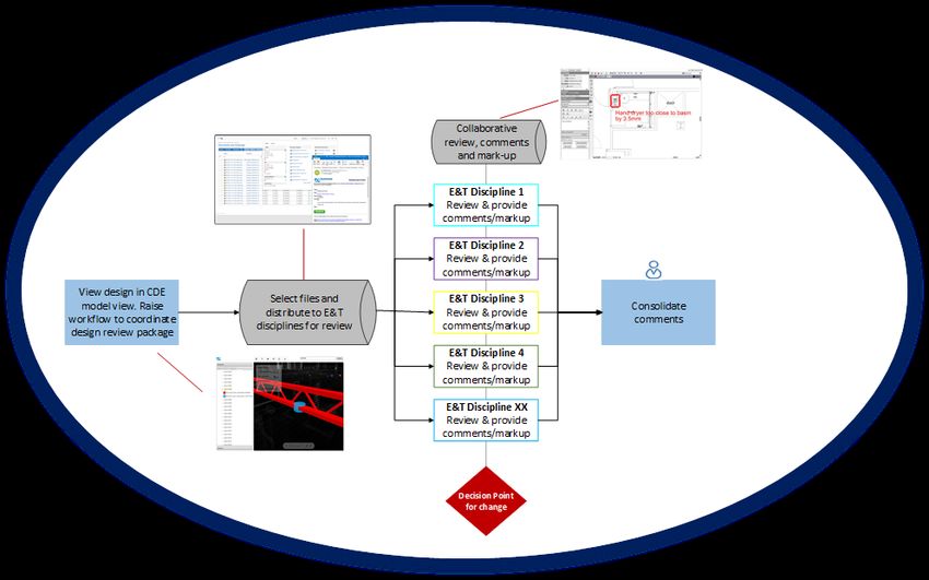
Contents

1     Introduction ....................................................................................................................................1
1.1   Purpose of the guideline ................................................................................................................. 1
1.2   Context ............................................................................................................................................ 1
1.3   Transport and Main Roads BIM implementation program and plan ............................................... 2
1.4   Benefits of BIM................................................................................................................................ 5
2     Transport and Main Roads BIM procurement documentation ..................................................6
2.1   Overview ......................................................................................................................................... 6
2.2   Transport and Main Roads Asset Information Requirements (AIR) ............................................... 8
2.3   Transport and Main Roads Exchange Information Requirements (EIR) ........................................ 8
2.4   Transport and Main Roads Project Information Requirements (PIR) ............................................. 9
2.5   Inclusion of BIM procurement documents in contract forms .......................................................... 9
2.6   Model Uses ................................................................................................................................... 10
2.7   Supplier BIM Execution Plan (BEP) ............................................................................................. 11
3     BIM and information management process ............................................................................. 11
3.1   Setting information requirements .................................................................................................. 11
3.2   Evaluation and assessment of BIM Execution Plans (BEPs) ....................................................... 12
3.3   Ensuring the Information Requirements are delivered ................................................................. 13
3.4   Common Data Environment (CDE) .............................................................................................. 14
4     Roles and responsibilities ......................................................................................................... 14
4.1   Transport and Main Roads – Project Manager............................................................................. 14
4.2   Transport and Main Roads – Project Information Manager ......................................................... 15
4.3   Transport and Main Roads – E&T Discipline Model Manager (Subject Matter Experts (SME)) .. 15
4.4   Supplier – Information Manager ................................................................................................... 16
4.5   Supplier – Task Team Information Manager ................................................................................ 16
4.6   Sub-contractor .............................................................................................................................. 16
5     Model Uses .................................................................................................................................. 17
5.1   Modelling existing conditions ........................................................................................................ 17
5.2   Civil/Structural Design – spatial and object-based design models ............................................... 18
5.3   Design visualisation for functional analysis .................................................................................. 19
5.4   Engineering modelling and analysis ............................................................................................. 21
5.5   Quantity take-off and cost planning .............................................................................................. 21
5.6   Clash detection/coordination ........................................................................................................ 22
6     2D drawing production ............................................................................................................... 23
7     Modelling and documentation practices .................................................................................. 24
7.1   Planning the modelling process .................................................................................................... 24
7.2   Model location and orientation ...................................................................................................... 24
7.3   Naming conventions and structure ............................................................................................... 24

Guideline, Transport and Main Roads, April 2021
                                                                                                                                                           i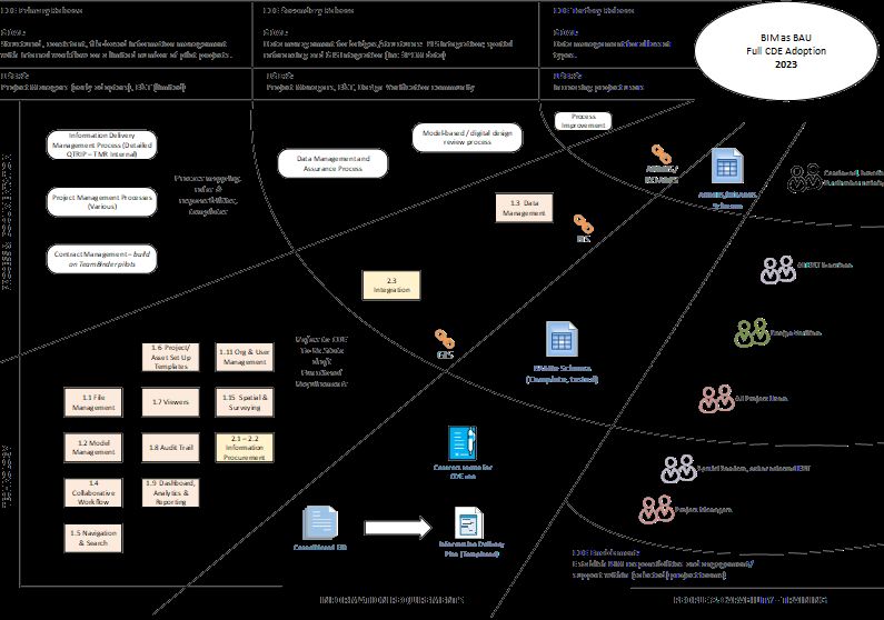
7.4    Asset element attributes ............................................................................................................... 25
       7.4.1     Element attributes tables – Civil .................................................................................. 25
       7.4.2     Element attributes tables – Lighting ............................................................................ 31
       7.4.3     Element attributes tables – Traffic Signals .................................................................. 33
       7.4.4     Element attributes tables – Information Technology Systems and Electrical (ITS&E) 36
8      Glossary ....................................................................................................................................... 41
9      References ................................................................................................................................... 43

Tables

Table 1.4(a) – Strategic objectives and benefits ..................................................................................... 5

Table 1.4(b) – Project objectives and benefits ........................................................................................ 5

Table 2.1 – BIM procurement documents ............................................................................................... 7

Table 2.6 – Transport and Main Roads core Model Uses ..................................................................... 10

Table 3.1 – Tasks required to compile BIM procurement documents ................................................... 12

Table 5.1 – Existing Conditions Modelling ............................................................................................ 17

Table 5.2 – Design Authoring ................................................................................................................ 18

Table 5.3 – Design Reviews (including visualisations) ......................................................................... 20

Table 5.4 – Engineering Analysis (Civil, Structural) .............................................................................. 21

Table 5.5 – Cost Estimation .................................................................................................................. 22

Table 5.6 – Clash detection / coordination ............................................................................................ 23

Table 7.4.1(a) – Drainage...................................................................................................................... 25

Table 7.4.1(b) – Pavements .................................................................................................................. 27

Table 7.4.1(c) – Road Furniture ............................................................................................................ 27

Table 7.4.1(d) – Noise Barriers ............................................................................................................. 29

Table 7.4.1(e) – Public Utility Plant ....................................................................................................... 30

Table 7.4.2 – Lighting ............................................................................................................................ 31

Table 7.4.3 – Traffic Signals .................................................................................................................. 33

Table 7.4.4 – Information Technology Systems and Electrical (ITS&E) ............................................... 36

Figures

Figure 1.3(a) – Transport and Main Roads BIM implementation program .............................................. 2

Figure 1.3(b) – Transport and Main Roads BIM implementation plan .................................................... 4

Figure 2.1 – BIM procurement documentation ........................................................................................ 6

Figure 3.3 – Design review process (CDE-enabled) ............................................................................. 13

Guideline, Transport and Main Roads, April 2021
                                                                                                                                                        ii
A guide to enabling BIM on Road Infrastructure Projects
1 Introduction
1.1 Purpose of the guideline
This document sets out the Building Information Modelling (BIM) direction for Transport and Main
Roads. The purpose of this document is to assist the department's Project Managers and project
stakeholders to implement BIM processes and methodology in the delivery of road infrastructure
projects during the planning, concept, development, implementation and finalisation phases.
In reading this document it is expected that departmental staff and project stakeholders will gain
knowledge of:
• Transport and Main Road’s BIM implementation program and plan.
• Why the department is adopting a digital approach to deliver capital projects.
• What are the key BIM procurement documents and how they need to be developed.
• What processes need to be followed to efficiently implement BIM on projects.
• Who is responsible for which activities.
1.2 Context
In the 2016 State Infrastructure Plan (SIP), the Queensland Government stated the intention to
introduce BIM to all projects by 2023, with a series of principles in draft to underpin whole of
Government adoption.
Transport and Main Roads has already developed its BIM processes and methodology and has
undertaken several pilot projects to test the challenges and benefits anticipated. BIM Implementation
will have an impact on the processes that underpin the planning, concept, development,
implementation and finalisation as well as operations and maintenance of the department’s
infrastructure projects.
As a member of the Queensland BIM Working Group, Transport and Main Roads was a key player in
the development and delivery of the Digital Enablement for Queensland Infrastructure – Principles for
BIM Implementation document published in November 2018 by the Department of State Development,
Manufacturing, Infrastructure and Planning (DSDMIP). This overarching document has been published
for use by all Queensland Government departments, agencies and statutory authorities and applies to
the full lifecycle, including design, delivery and asset management, of all new major state
infrastructure assets.
In line with the principles outlined in the publication, the department’s focus is ensuring the
implementation strategy aligns with the four key principles of:
Guideline, Transport and Main Roads, April 2021
1A guide to enabling BIM on Road Infrastructure Projects
Transport and Main Roads has been applying BIM principles on major projects since 2016. The
department’s criteria on the application of BIM are as follows:
• All major projects shall implement BIM methodologies using the department’s specifications
effective immediately, taking into account:
− Complexity / Characteristics (For example, the requirements for complex staging, and
interfacing with other infrastructure or built environment).
− Capability (The level of collaboration and knowledge of BIM, required and/or available
within Transport and Main Roads and industry).
− Contract type (Alignment with contract provisions and risk allocation).
1.3 Transport and Main Roads BIM implementation program and plan
The department’s BIM Implementation Program has been in development for several years, resulting
in over 30 BIM-enabled projects to date. BIM for the department represents the development of
3D object-based modelling in road design, alongside robust processes and defined requirements for
information and data management in project delivery.
To meet the Queensland Government's direction, the department has developed its own BIM
Implementation Strategy with four "workstreams" as outlined in Figure 1.3(a) below.
Figure 1.3(a) – Transport and Main Roads BIM implementation program
Transport and Main Road’s BIM implementation vision is
To drive information sharing efficiencies within all phases of an asset’s lifecycle
Guideline, Transport and Main Roads, April 2021
2A guide to enabling BIM on Road Infrastructure Projects
Efficiencies will be realised through the adoption of international standards for information
management using BIM (ISO 19650) which will enable Transport and Main Roads and their suppliers
to receive and share all required information during the correct project phases to enable informed
decisions.
As indicated in Figure1.3(b), the Implementation Plan’s four workstreams are designed to progress in
parallel to achieve the most effective implementation of BIM processes into Transport and Main
Roads.
Guideline, Transport and Main Roads, April 2021
3A guide to enabling BIM on Road Infrastructure Projects Figure 1.3(b) – Transport and Main Roads BIM implementation plan Guideline, Transport and Main Roads, April 2021 4
A guide to enabling BIM on Road Infrastructure Projects

1.4       Benefits of BIM

Transport and Main Road’s BIM program will promote the avoidance of wasteful activities, in
accordance with ISO 19650 series.

Wasteful activities may include:

      •    Waiting and searching for information.

      •    Over-production of information with no defined use.

      •    Difficulties to identify ownership, validity, and currency of information.

      •    Defects caused by poor co-ordination across graphical and non-graphical data sets, resulting
           in rework.

The departmental BIM Implementation objectives and benefits are outlined in Table 1.4(a) and
Table 1.4(b), differentiated between Strategic (S) and Project (P) objectives.

Table 1.4(a) – Strategic objectives and benefits

                          Objective                                             Benefits
 S1        Achieve consistency for the                    Consistency creates efficiency benefits while
           management of asset information and            improving quality in information procurement and
           data in the Queensland Transport and           management. Providing suppliers with a
           Roads Investment Program (QTRIP)               consistent process will make it easier for
           process, including the necessary               consultants and contractors to respond to the
           requirements for departmental suppliers        department’s BIM requirements and improve
           to meet their asset information and data       assessment.
           obligations.
 S2        Provide the consistent processes and           • Reduction in time required to complete
           tools to achieve the business change             business functions (e.g. design verification).
           and associated benefits identified by          • Fewer variations.
           Transport and Main Road’s BIM
           Implementation Plan.                           • Fewer time and cost overruns.
                                                          • Reduced manual work at handover.
 S3        Provide the necessary technology,              This ensures industry development is in line with
           process and documentation to meet              departmental requirements. Alignment with
           current international BIM standards.           supplier expectations on information management
                                                          and modelling approaches, drives consistency,
                                                          increases speed of delivery and improves the
                                                          quality of project outcomes.

Table 1.4(b) – Project objectives and benefits

                          Objective                                             Benefits
 P1        Better information management                  • Less time required to find information.
                                                          • Ensure consistency on procuring, collecting
                                                            and managing information.
                                                          • Reduce errors/information lost/duplication.
                                                          • Lower risk and better predictability of
                                                            outcomes.
 P2        Communication and visualisation                • Enhance collaboration, communication, and
                                                            productivity.
                                                          • Improve visualisation for better decision-
                                                            making.

Guideline, Transport and Main Roads, April 2021                                                               5
A guide to enabling BIM on Road Infrastructure Projects
Objective Benefits
P3 Design Co-ordination • Reduce re-work from better coordination and
clash detection.
• Reduce conflicts and changes during
construction.
P4 Design Review • Improve efficiency in design reviews and
approval cycles.
P5 Asset Management • Improve data collection for digital Operate and
Manage (O&M) handover and asset information
creation.
2 Transport and Main Roads BIM procurement documentation
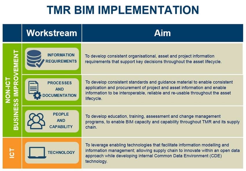
2.1 Overview
The key documents to implement BIM within the department’s capital project and the relationships
between the various BIM procurement documents are shown in Figure 2.1.
Figure 2.1 – BIM procurement documentation
The suite of documents to the left of the contract line form part of the appointment and tender
documents which enable suppliers to detail their response in their initial BIM Execution Plan (BEP), to
the right of the contract line.
The BEP sets out the supplier’s detailed plan for the production, management and quality controls of
information delivered under the contract.
The BIM procurement documents are a combination of ‘static’ departmental documents used across
all projects without alteration, and templates that are modified for each individual project. These
documents are applicable to all QTRIP projects and are based on Transport and Main Road’s
standard suite of procurement routes.
Guideline, Transport and Main Roads, April 2021 6A guide to enabling BIM on Road Infrastructure Projects
The information requirements are aligned to international best practice standards which include the
ISO 19650 series.
The processes outlined in ISO 19650-2 should be considered in conjunction with the department’s
Transport Infrastructure Project Delivery System (TIPDS).
These BIM requirements are intended to support and enable an agile and consistent approach to all
project activities by adopting digital ways of working. The focus is on ensuring that the right people
have the right information at the right time and in the right format to effectively carry out their roles
from inception of the project through to operation and decommissioning.
A high-level definition of each BIM procurement document is detailed in Table 2.1.
Table 2.1 – BIM procurement documents
Document Description How it is issued Update frequency
Asset Information Defines the specific Maintained by the Static document
Requirements information and data which department as an applied across all
(AIR) must be delivered, to overarching asset projects (updated
achieve Transport and requirement guide. from time to time as
Main Road’s target state lessons are learned).
Asset Information Model
(AIM).
Exchange Sets out managerial, Issued to Suppliers. Static document
Information commercial and technical applied across all
Requirements aspects of producing projects (updated
(EIR) project information. This from time to time as
includes the standards, lessons are learned).
methods and procedures to
be implemented by the
delivery team producing a
Project Information Model
(PIM).
Project Defines the specific Issued to Suppliers. Populated for each
Information information requirements project.
Requirements for the project, (for
(PIR) example, specific
requirements beyond the
AIR/EIR, timing
requirements and any
specifics relating to
information delivery and
transmission.
BIM Execution A document that is Issued by supplier. To be created by
Plan (BEP) produced by the supplier in supplier.
response to the EIR. It
describes the processes
and standards that the
team will adopt to deliver
the requirements of the
EIR.
Guideline, Transport and Main Roads, April 2021 7A guide to enabling BIM on Road Infrastructure Projects
2.2 Transport and Main Roads Asset Information Requirements (AIR)
The objective of the AIR is to provide a clear statement of the requirements that will enable the project
to deliver an AIM comprising of:
• A structured asset register, including asset characteristics suitable to Transport and Main
Road’s asset management requirements.
• An organised repository of drawings, documents and files required for the operational and
maintenance phase of the asset lifecycle.
• Accurate as-constructed model/s (including associated data and information).
• Coordinated components consistently cross-referenced, with minimal duplication of data,
presented in a format appropriate to the organisation’s systems and management capabilities.
As a State Government organisation Transport and Main Roads has legislative requirements for asset
management. The Transport Infrastructure Asset Management Policy and supporting documents
define the Organisational Information Requirements (OIR) and Asset Information Requirements (AIR)
for the department. A review of these overarching policy / procedural documents is required to confirm
the alignment of these documents with ISO 19650 workflows for data capture.
There are three Asset Management Systems that currently store asset information for the department,
they are:
• ARMIS – A Road Management Information System.
• BIS – Bridge Information System.
• ROAMS – Road Operations Asset Management System.
A review of the asset information requirements across these three major asset management
databases is being undertaken to ensure correct asset information is captured during project delivery.
To ensure accuracy and completeness of the Asset Information Model (AIM) it should be produced as
an output from the Project Information Model (PIM). This assumes the PIM is the one source of truth
for all project information throughout design, construction, commissioning and handover phases. The
purpose of the AIM is to provide information that will support the ongoing management of the asset.
The AIM should deliver a fully populated asset data set to be used by the department’s Asset
Information Management Systems.
2.3 Transport and Main Roads Exchange Information Requirements (EIR)
The EIR specifies the department's project and asset information requirements, reasons and purpose
to the project team. It also outlines the technical standards and commercial procedures to enable BIM
and information management.
The EIR is a critical element of BIM and information management and it is used to clearly define to
project teams what information (models, data and documents) is required to successfully enable BIM
at each project stage.
Essentially the EIR establishes:
• What information is needed? – Detailed information requirements.
• Why the information is needed? – Defined information purpose.
Guideline, Transport and Main Roads, April 2021 8A guide to enabling BIM on Road Infrastructure Projects
The EIR is reviewed by the Project Manager prior to engaging a supplier and it will form part of the
contract. All Project Briefs for the engagement of suppliers must provide clear definition of the EIR for
each stage of project development.
All proponents tendering for departmental projects will be required to demonstrate the proposed
approach, capability, and capacity to deliver the BIM requirements for the department though the
development of a BEP as outlined in the EIR provided during tender engagement.
2.4 Transport and Main Roads Project Information Requirements (PIR)
The Project Information Requirements (PIR) captures the specific information to inform and manage a
project. The AIR and EIR will mainly cover the standard departmental asset and project requirements
for projects, while the PIR must be populated by the Project Manager for each project and/or work
package.
PIR will include:
• Details of the project such as unique project challenges and risks and how BIM can be used to
mitigate them.
• Identify Model Uses to be delivered by the awarded proponent during project delivery.
• When information is needed and who is responsible for sharing the information, including
project milestones and information exchange timings outlined in the responsibility matrix.
• Who is undertaking which information management / BIM roles.
• What existing information is available about the project (for example surveys, drawings or
models).
• Any additional requirements above and beyond the EIR and AIR (such as specific legislative
requirements or information requirements required to test new innovations).
• Any agreed deviations against the EIR and AIR (such as reduction in requirements due to the
scope of the project, for example if it involves minor work or refurbishment).
• Responsibility matrix defining the Level of Definition (LOD) of the model and related
responsibilities.
The PIR defines requirements for the data, information and models which need to be produced at
each project stage along with the required Level of Information Need (LOIN) and their purpose. This
data, information and models collectively form the PIM.
The PIR is the responsibility of, and should be completed by Transport and Main Roads, but can be
discussed and produced in collaboration with relevant suppliers where appropriate.
2.5 Inclusion of BIM procurement documents in contract forms
The approach for inclusion in contract documents will depend on the underlying contract form and
procurement approach.
Collaborative Project Agreement (CPA) Approach:
BIM Procurement Documents are included/dispersed through the Statement of Works and Technical
Criteria (SWTC) generally used for Transport Infrastructure Contract – Design & Construct
(TIC – D&C) contracts as follows:
• Appendix 34: BIM EIR
Guideline, Transport and Main Roads, April 2021 9A guide to enabling BIM on Road Infrastructure Projects
• Appendix 7: Project Plans (inc BIM Execution)
• Appendix 7 Attachment 7A: Information Delivery Milestones
• Appendix 10: As-Constructed Information Requirements
Engagement of Consultant's For Professional Engineering (CFEP) Manual and Transport
Infrastructure Contract – Construct Only (TIC – CO) – Functional Specification Approach:
• The AIR, EIR and PIR will be included or referenced within the Functional Specification for
each phase of project development (Options Analysis, Business Case, Preliminary Design,
and Detailed Design).
2.6 Model Uses
The defined Model Uses represent Transport and Main Road's desired outcome for 3D models being
used on the project. The department's Project Manager together with the Project Information Manger
will identify in the PIR the Model Uses to be requested under the Contract. Transport and Main Roads
has identified the following core Model Uses detailed in Table 2.6; refer to Appendix 1 for further
specification.
Table 2.6 – Transport and Main Roads core Model Uses
Model Use Description
Modelling existing conditions Define the extent of existing conditions to be modelled under
the project details in the EIR.
Civil/Structural Design – spatial A process in which 3D software is used to develop a model
and object-based design models based on design criteria for transport infrastructure design.
Two groups of applications at the core of BIM based design
processes are design authoring tools and audit and analysis
tools.
Design visualisation for A process in which a 3D model is used to showcase the
functional analysis design to the stakeholders and design reviewers to evaluate
the compliance of the design to the relevant design
standards while meeting the initial project scope
requirements.
Engineering modelling and A process in which intelligent modelling software uses the 3D
analysis model to determine the most effective engineering
solution/method based on design specifications. These
analysis tools and performance simulations can significantly
improve the design of infrastructure.
Quantity take-off and cost A process in which a 3D model can be used to assist in the
planning generation of accurate quantities of materials and cost
estimates early in the design process and provide cost
effects of various design options with the potential to save
time and money and avoid budget overruns. Cost estimation
will occur throughout each phase of the project development
allowing financial management tracking against budget
allocation.
Clash detection/coordination A process in which clash detection software is used during
the coordination process of design elements to determine
field conflicts by comparing 3D models of roadway
components including subsurface elements. The goal of
clash detection is to eliminate the major system conflicts
prior to construction.
Guideline, Transport and Main Roads, April 2021 10A guide to enabling BIM on Road Infrastructure Projects
Model Use Description
2D Drawing production The primary purpose of project drawings is to clearly
represent the design that is required to be constructed. 2D
drawing information for the purposes of assembling a printed
set of plans shall be derived from the 3D model(s) to the
fullest extent possible.
2.7 Supplier BIM Execution Plan (BEP)
The BEP is a formal document that is submitted by the proponents during a tender process, for design
and construction phases (which could be issued separately depending on the procurement approach),
outlining how they intend to meet the BIM requirements defined in the department’s EIR and
associated contract documents, for example, PIR, Functional Specification or SWTC used in the
different contract types. During the design, the supplier Information Manager shall create a BEP based
on the requirements defined in the PIR and EIR and shall reference the relevant sections from this
document. This will enable all parties to understand whether the BIM requirements and uses will be
met for specific project stages.
At tendering stage, the tendering contractors shall create a BEP based off the previously developed
BEP and reference the relevant PIR and EIR sections where applicable. The BEP shall be included as
part of the contractor’s tender submission.
The department does not have a BEP template; it is the responsibility of the proponent to prepare the
BEP for the project outlining how they will address the following:
• Project information
• Project schedule
• BIM goals
• Project team roles, staffing and competency
• detail of individuals undertaking the information management function
• information delivery strategy including the team approach to meeting the department’s EIR
and PIR
• the delivery team’s high-level responsibility matrix
• proposed federation strategy
• collaboration procedures and method to handle shared models
• quality control
• plan for file sharing, storage and retrieval, and data security, and
• technology infrastructure and software.
3 BIM and information management process
3.1 Setting information requirements
QTRIP project contracts need to include comprehensive requirements for suppliers to provide a full set
of information about every asset when it is handed over.
Guideline, Transport and Main Roads, April 2021 11A guide to enabling BIM on Road Infrastructure Projects
As described above, the EIR and PIR are the primary documents for communicating information
requirements and establishing information management processes from Transport and Main Roads to
its suppliers.
A key step in setting up the team for development of the EIR / PIR is to nominate a competent
individual for the information management role (Project Information Manager). The Project Information
Manager role can be covered by departmental staff or a third party working on behalf of the
department. Their role will be to ensure that the project acquires knowledge about the assets to be
specified and handed over. It is the responsibility of the Project Manager to ensure this role is
established at the beginning of the project.
The Project Information Manager performs a key, integral function alongside all other project
management activities. As such the role holder must be fully supported by and closely aligned with the
Project Manager.
Table 3.1 defines the activities required to implement the BIM procurement documents.
Table 3.1 – Tasks required to compile BIM procurement documents
Document Responsible Tasks
AIR and EIR Transport and Main • Brief internal Transport and Main Roads Project
Roads Project Team on the requirements.
Information Manager
EIR / PIR Transport and Main • Complete the EIR / PIR incorporating the
Roads Project responsibility matrix.
Information Manager • Brief internal Transport and Main Roads Project
Team on the requirements.
BEP Suppliers • Provide a BEP responding to the requirements
highlighted in the EIR.
• Following contract award, agree on approach with
Transport and Main Roads Project Information
Manager.
• Ensure supply chain have been briefed and have
the capability to meet the requirements.
Transport and Main • Evaluate BEP quality and completeness as part of
Roads Project the tender stage.
Information Manager • Following contract award, review the supplier’s
BEP and confirm that it complies to the
requirements.
3.2 Evaluation and assessment of BIM Execution Plans (BEPs)
The evaluation and assessment of BEPs will be undertaken by the Transport and Main Roads Project
Manager and Transport and Main Roads Project Information Manager. In the process of finalising the
contract with the successful proponent, the BEP is revisited and updated as required. The BEP is to
be treated as a live document and is to be updated as the project develops, agreed approaches to
BIM change, or individual roles and responsibilities are changed.
Guideline, Transport and Main Roads, April 2021 12A guide to enabling BIM on Road Infrastructure Projects 3.3 Ensuring the Information Requirements are delivered Once the BEP is agreed, validation and verification checks should be undertaken by the Transport and Main Roads Project Information Manager on behalf of the department's Project Manager. In particular, the Transport and Main Roads Project Information Manager is responsible for validating the information and deliverables provided by the supplier against the requirements stated in the PIR and EIR. The Transport and Main Roads Project Information Manager is also responsible for coordinating the review process at every information exchange to include input from relevant E&T Discipline Model Managers (Subject Matter Experts (SMEs)) to ensure compliance. Figure 3.3 shows the Design review process: Information will be submitted to the department by the Supplier Information Manager at the relevant project milestones into the agreed Common Data Environment (CDE). The Project Information Manager is responsible for raising the collaborative workflow to coordinate design review by distributing the files among the E&T Discipline Model Managers and managing the process until all comments are closed. The CDE will support the collaborative review and the CDE will keep a record of the comments and mark-ups. Figure 3.3 – Design review process (CDE-enabled) Guideline, Transport and Main Roads, April 2021 13
A guide to enabling BIM on Road Infrastructure Projects

3.4    Common Data Environment (CDE)

The CDE is a technology platform that provides a single source of truth for all project information. It is
used to collect, manage, and disseminate all relevant project information in a managed process that
allows information to be shared between all members of the project team.

To support the BIM implementation Transport and Main Roads intends to procure a CDE solution to
manage asset information. The CDE will support the capture of digital data and asset information,
including contractual documents and correspondence, during the QTRIP phases and ongoing Operate
and Manage phases of the asset lifecycle. The CDE solution will also meet the needs of Collaborative
Contract Management, i.e. the management of contractual documents and correspondence (such as
drawings, specifications, letters, inspector diaries, photographs, lots, etc) on an infrastructure project.

Currently and prior to a Transport and Main Roads enterprise CDE being available, the department's
Project Manager and department's Project Information Manager should agree with their suppliers on
the best approach to software use to provide CDE functionality. For example, recent major projects
have used a combination of Collaborative Contract Management Software (CCMS) for some CDE
functions, supported by contractor owned CDE platforms for model sharing and viewing.

4     Roles and responsibilities
Transport and Main Roads has developed the following roles and responsibilities to provide clarity to
project teams.

The department will establish the roles outlined below, with both general and specific BIM and
information management responsibilities. It is expected that the contractor will provide equivalent roles
to interact with the department. The contractor resources must take full responsibility for delivery of
BIM and information management for their contracted part of a Transport and Main Roads project.

Roles and responsibilities are defined below and should not be confused with job titles and do not
necessarily reflect full time equivalent (FTE) positions. It is important to consider these roles in terms
of ownership, responsibility and authority.

4.1    Transport and Main Roads – Project Manager

The Project Manager must retain overall control of the project program, deliverables and
communication. To support BIM the Transport and Main Roads Project Manager must perform the
following activities:

               Role                                           Responsibilities
                                    • Assign a Project Information Manager for the project.
                                    • With assistance from Project Information Manager, prepare the
                                       EIR/ PIR to go out during tender evaluation.
                                    • Review and comment on BIM Execution Plans (BEPs).
                                    • Guide in the establishment, monitoring and reporting of BIM
                                       KPIs.

Guideline, Transport and Main Roads, April 2021                                                              14
A guide to enabling BIM on Road Infrastructure Projects
4.2 Transport and Main Roads – Project Information Manager
Role Responsibilities
• Assist the Transport and Main Roads Project Manager to
complete the, EIR / PIR to go out during tender evaluation (for
smaller projects, this role could be taken by the department's
Project Manager).
• Lead in the evaluation of the BEP received from contractors
during the tender evaluation.
• Establish, monitor and report BIM KPIs.
• Periodic reviews of project processes, outputs and compliance
against the EIR / PIR for auditing purposes.
• Manage the Transport and Main Roads CDE (depending on
solution adopted and as defined in the EIR / PIR).
• Manage and maintain the exchange of information between
stakeholders.
• Report on the delivery of information exchanges at all project
stages/milestones to the Transport and Main Roads Project
Manager.
• Enable integration and coordination of information within the
PIM.
4.3 Transport and Main Roads – E&T Discipline Model Manager (Subject Matter Experts
(SME))
Role Responsibilities
• Review and comment on the BEP.
• Ensure relevant discipline models comply with the EIR.
• Approve graphical models and design artefacts developed.
Guideline, Transport and Main Roads, April 2021 15A guide to enabling BIM on Road Infrastructure Projects
4.4 Supplier – Information Manager
Role Responsibilities
• Develop the BEP.
• Liaise with Task Team Information Managers to include their
inputs into the BEP.
• Coordinate delivery of information into Transport and Main
Roads CDE at designated data drops / exchanges
• Manage spatial coordination on behalf of the whole project team.
• Ensure production of information in compliance with standards
and methods.
4.5 Supplier – Task Team Information Manager
Role Responsibilities
• Support the BEP development by providing Task Team
Information Delivery Plans to the Supplier – Information
Manager.
• Ensure information is delivered as per Responsibility Matrix.
• Confirm suitability of models throughout project to enable
collaboration.
• Manage spatial coordination on behalf of the discipline specific
team.
• Manage clash avoidance where sub-contracted assets interface.
• Manage all coordination and clash detection within contracted
part of graphical models.
4.6 Sub-contractor
Role Responsibilities
• Input into the main contractor's Task Team Information Delivery
Plans to support the project BEP.
• Coordinate delivery of information into main contractor's CDE or
Transport and Main Roads CDE at designated data drops.
• Production of design outputs related to a discipline specific
package of work.
• Production of information in compliance with standards and
methods.
• Ensure information is delivered as per Responsibility Matrix
• Confirm information is suitable for issue to the CDE.
• Manage spatial coordination on behalf of the discipline specific
team.
• Propose resolutions to coordination issues / clashes.
Guideline, Transport and Main Roads, April 2021 16A guide to enabling BIM on Road Infrastructure Projects
5 Model Uses
Some of the below-described Model Uses will be commonly used on projects, others are an indication
of where BIM may be applied in the future. Examples of BIM Uses that could be requested under the
Contract may include:
5.1 Modelling existing conditions
Define the extent of existing conditions to be modelled under the project details in the Project BIM
Brief.
The area over which the Ground and Feature Model (GFM) to be established should be clearly
defined in the Survey Brief.
GFM surveys are used for recording the current status of the existing conditions of the project site and
define a project’s topography and locate those existing features, both surface and sub-surface, which
may influence a road infrastructure project.
Table 5.1 – Existing Conditions Modelling
Existing Conditions Modelling
Description
This model will be developed to create a discipline model, as part of the PIM, of the existing
conditions of the project site. It will represent the digital terrain model of the existing surfaces of the
site and will include both surface objects and underground objects within the boundaries of the site
limits. The TMR Surveying Standards defines this model as the Ground and Features Model
(GFM).
Further Project Information Modelling details that cover hydraulic modelling, geotechnical reports,
Dial Before Your Dig (DBYD) services information, and so on, also form part of the Existing
Conditions Modelling (ECM) and should be provided for the project.
Potential Value
• representation of existing natural surface
• guides the development of horizontal and vertical alignment design
• provide interface between design and natural surface for earthworks calculations
• aid to clash detection for both surface and subsurface objects, e.g. underground services
• enhance efficiency and accuracy of existing conditions documentation
• use for visualisation purposes, and
• provision of all relevant ECM models, drawings, and reports further enhances the project
knowledge leading to more informed project decision making.
Resources Required
• Ground and Feature model development
• TMR Surveying Standards for model and string naming conventions
• 3D Model manipulation
• 3D Laser scanning, if required, and
• 3D Laser scanning point cloud translation into objects, if required.
Team Competencies
• ability to manipulate, navigate, and review a 3D model
• knowledge of BIM authoring tools, and
• knowledge of 3D laser scanning tools.
Guideline, Transport and Main Roads, April 2021 17A guide to enabling BIM on Road Infrastructure Projects
Existing Conditions Modelling
Selected Resources
• TMR Surveying Standards and Surveying Technical Notes
5.2 Civil/Structural Design – spatial and object-based design models
Design model requirements are defined in the department's Drafting and Design Presentation
Standards Manual, Volume 1: Chapter 5 – Project Electronic Models 1. Examples are provided
showing preferred Model Names and indicative model content. For the department’s BIM adoption
there may be an aggregation of specific discipline models listed in the manual into a single Federated
model. An example of this aggregation of models is shown below:
• Survey – Existing Conditions Modelling
• Civil Infrastructure
• Structures – bridges (Superstructure, Substructure, additional models)
• Drainage – cross drainage culverts and longitudinal networks
• Electrical, Communications and Reticulation
• Utility Infrastructure – all third-party Public Utility Plant infrastructure (Depending on level of
complexity this model may be expanded to have individual services represented in their own
model)
• Tunnels – surfaces and components
• Intelligent Transport Systems
• Landscaping
• Noise attenuation, and
• Environment
Table 5.2 – Design Authoring
Design Authoring
Description
A process in which a software is used to develop a discipline model, as part of the PIM, based on
design criteria for transport infrastructure design. Two groups of applications at the core of BIM
based design process are design authoring tools and audit and analysis tools.
Authoring tools create models while audit and analysis tools study or add richness of information in
a model. Most audit and analysis tools can be used for Design Review and Engineering Analysis
BIM Uses.
Design Authoring tools are a first step towards BIM and are key in connecting the 3D Model with a
powerful database of properties, quantities, costs and schedules.
1Note that a complete review of this guideline still needs to be undertaken to better define 3D Object
based model naming conventions
Guideline, Transport and Main Roads, April 2021 18A guide to enabling BIM on Road Infrastructure Projects
Design Authoring
Potential Value
• transparency of design for all stakeholders
• better control and quality control of design, cost and schedule
• powerful design visualisation
• true collaboration between project stakeholders and BIM users, and
• improved quality control and assurance.
Resources Required
• model authoring software certified as being suitable for use with the most current version of
Industry Foundation Class (IFC) file format
• model Authoring Software certified as being able to export native files to IFC format without the
loss of geometric integrity
• traditional 2D documentation, in a digital format, prepared with approved IFC compliant BIM
authoring software and plans, and
• commercially available model checking software that provides interoperability between different
software applications.
Team Competencies
• ability to manipulate, navigate, and review a 3D model
• knowledge of design standards and their application, and
• knowledge of construction means and methods.
Selected Resources
• Design Authoring software tutorials, and
• Transport and Main Road's design technical policies, standards, and guidelines.
5.3 Design visualisation for functional analysis
BIM provides the opportunity to build a virtual road or bridge and to virtually test that road or bridge for
functionality during design. This allows project stakeholders to see and understand design solutions
that represents reality so they can work towards improving the road or bridge design before
construction starts.
The Design Team is encouraged to find efficiencies and uses for BIM to enhance communication for
the project. At a minimum, the model shall be integrated into design reviews, review submittals, and
3D construction documentation views. Areas that would benefit from the use of 3D imagery and fly-
throughs during the design process and during construction shall be identified and noted in the PIR.
Visualisation tools refer to animated models, fly-throughs, static 3D renderings, 4D process
sequencing, and other techniques to assist decision making and comprehension. It should be noted
that even though the individual discipline or federated models contain most of the source information
needed for visualisation, they may require further refinement in specific animation and visualisation
software to accomplish the intended results.
During design, special consideration should be given to alignment coordination and sight visibility
issues that can be modified to improve the safety and operational aspects of the design. Consider the
following uses of BIM for communication purposes and record those selected in the Project BIM Brief.
Guideline, Transport and Main Roads, April 2021 19A guide to enabling BIM on Road Infrastructure Projects
The purpose, intended users, nature (static or animated), level of detail (outline, photorealistic, etc)
and scope of each should also be defined such as:
Visualisation:
a) views of the roadway elements at specific locations or points of interest in isometric or
orthographic projections
b) sectional views through the models at specific locations or points of interest
c) enhanced visualisations for presentation purposes using photorealistic rendering software and
photomontages of the proposed design, and
d) simulated videos of the road, e.g. 'fly overs', 'fly throughs'.
Table 5.3 – Design Reviews (including visualisations)
Design Reviews (including visualisations)
Description
A process in which a federated model is used to showcase the design to the stakeholders and
design reviewers to evaluate the compliance of the design to the relevant design standards while
meeting the initial project scope requirements.
The Design Team is encouraged to find efficiencies and uses for BIM to enhance communication
for the project. At a minimum the models shall be integrated into design reviews, review
submissions, and 3D construction views.
Potential Value
• 3D review can highlight sight line and alignment coordination issues that are difficult to detect in
2D plans views
• project drive-through / fly overs are more easily understood by the community
• create shorter and more efficient design reviews, and
• easily communicates the design to the client and allows instant feedback on meeting design
requirements.
Resources Required
• 3D model manipulation
• Design authoring software
• 3D visualisation tools within the design authorising software
• additional visualisation software applications that may enhance the native file format, and
• Interactive Review capability.
Team Competencies
• ability to manipulate, navigate, and review a discipline and federated model, and
• ability to apply textures and drapes with the design modelling software.
Selected Resources
• Transport and Main Roads Drafting and Design Presentation Standards, Volume 1, Chapter 6:
Visualisation, and
• design authorising software visualisation tutorials and help files.
Guideline, Transport and Main Roads, April 2021 20A guide to enabling BIM on Road Infrastructure Projects
5.4 Engineering modelling and analysis
The design teams will utilise intelligent modelling authoring software to create the BIM models for their
respective disciplines to determine the most effective engineering solution/method based on design
specifications.
For each discipline specific model, the Model Element Authors will document what design analysis
tools were used to validate the design against the engineering standards applicable to the respective
disciplines, e.g. cross sections, sight distance checking, design vehicle swept path analysis, structural
analysis in bridge design. In some instances, this design analysis can be demonstrated by inclusion of
visual outputs in the federated model file viewer, e.g. Swept Path analysis in Saved Viewpoints.
All engineering disciplines shall provide the RPEQ engineer with models that identify the location and
extent of all major infrastructure elements.
Table 5.4 – Engineering Analysis (Civil, Structural)
Engineering Analysis (Civil, Structural)
Description
A process in which intelligent modelling software uses the federated model to determine the most
effective engineering solution / method based on design specifications. These analysis tools and
performance simulations can significantly improve the design of the infrastructure.
Potential Value
• automating analysis and saving time and cost
• achieve optimum design solution by applying various rigorous analyses, and
• improve the quality of the design and reduce the cycle time for design analyses
Resources Required
• 3D model manipulation
• engineering analysis tools and software, and
• structural modelling and analysis tools and software
Team Competencies
• ability to manipulate, navigate, and review a federated model
• ability to assess a model through engineering analysis tools
• knowledge of construction means and methods, and
• design and construction experience.
Selected Resources
• engineering analysis tools for civil and structural design and analysis
5.5 Quantity take-off and cost planning
Cost Estimation may be used across all phases of project development including design and
construction. During the design phases the process can be used for quantity take-off to determine
material quantities from the design models for inclusion in the estimating process.
Refer to the department’s Project Cost Estimating Manual for more detail on the process for
developing project cost estimates at the various phases of project development.
Guideline, Transport and Main Roads, April 2021 21You can also read