TUNA MIGRATIONS GULF OF MEXICO - JORGE BRENNER AND VALERIE MCNULTY - WEBFLOW
←
→
Page content transcription
If your browser does not render page correctly, please read the page content below
GULF OF MEXICO
TUNA MIGRATIONS
Jorge Brenner and Valerie McNulty

                                    PHOTO © TIM CALVER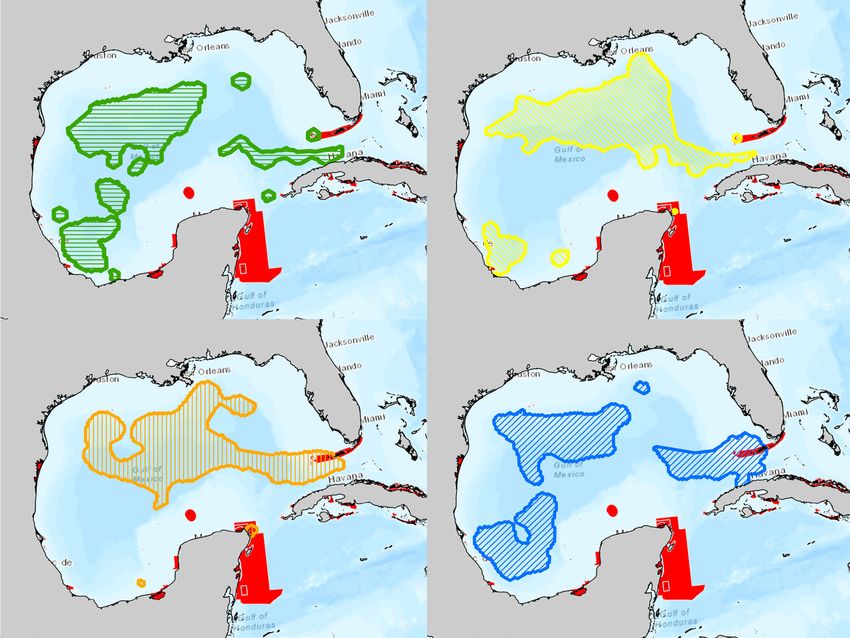
PHOTO © KEVIN ARNOLD

                                                                                                   Contents

ACKNOWLEDGEMENTS

This report is a part of the Migratory Species Conservation
Project. For more information, visit migratoryblueways.org and
maps.bluewaysconservation.org.

This project was made possible due to the generous financial
support of an anonymous private donor, as well as The Nature
Conservancy’s Global Oceans Team and Texas Chapter. The au-
thors would like to thank the guidance provided by this project’s
Scientific Steering Committee: Dr. Billy Causey of the Nation-                                                     Introduction                                      2
al Marine Protected Areas Center of the National Oceanic and
Atmospheric Administration, Dr. Félix Moncada of the National
Fisheries Research Center of Cuba, Dr. Frank Muller-Karger of
the University of South Florida, Dr. Rodolfo Claro formerly with
the Institute of Oceanology in Cuba, Dr. Ruth Perry of Shell, Dr.
William Kiene formerly with the Office of National Marine Sanc-                                                    Mapping Tuna Migrations                           6
tuaries of the National Oceanic and Atmospheric Administra-
tion, and Dr. John ‘Wes’ Tunnell of the Harte Research Institute
for Gulf of Mexico Studies at Texas A&M University-Corpus
Christi (1945-2018). The authors would like to especially ac-
knowledge the contributions of the scientists and institutions                                                     Key Findings and Limitations                    18
that supported this project by providing datasets, comments,
and reviews essential to the development of these analyses and
this report (for a full list of contributors, visit migratoryblue-
ways.org). Special thanks to Dr. Rich Bell, Dr. Robert Bendick,
Randy Blankinship, Dr. William Driggers, Linda Elkin, Dr. Ben-
jamin Galuardi, Dr. Walter Ingram, Dr. César Meiners, Dr. Todd                                                     The Way Forward                                 22
Phillips, Karina Ramírez, Dr. Steve Schill, Dr. Pedro Ulloa, and Lily
Verdone.

Illustrations and design by Valerie McNulty.

Suggested citation for this report:
Brenner, J. and V. McNulty. 2018. Gulf of Mexico Tuna Migrations. The Nature Conservancy,
Arlington, 24 pp.

                                                                                                THE NATURE CONSERVANCY | GULF OF MEXICO		 GULF OF MEXICO TUNA MIGRATIONS			1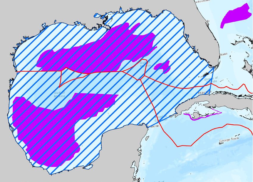
Introduction
                                                                                          Figure 1. Gulf of Mexico study area and commercial tuna fishing areas
                                                                                          for the United States, Mexico, and Cuba. Commercial fisheries in the U.S.
                                                                                          mainly target yellowfin tuna, so its adult Essential Fish Habitat (NOAA) is
                                                                                          used as an approximate U.S. tuna fishing area here (Levesque 2011).

                                                                                                                                                                Tuna
             The Gulf of Mexico large marine ecosystem (hereafter the Gulf)                                                                                     Fishing Areas
             is a biodiverse and productive international sea, booming with
             activity such as offshore energy development, shipping, commer-
             cial and recreational fishing, and tourism. Due to its geographic                                                                                  Project
             location between North America and the Caribbean Sea, it is                                                                                        Study Area
             also filled with a wealth of migratory fish, sea turtles, marine
             mammals, and birds that seasonally take advantage of its vast
             resources, habitats, and weather. However, issues arise when
             human activity blocks their migrations and prevents them from
             completing their life cycles.

             Migratory tunas make up 20% of the value of marine capture
             fisheries and over 8% of globally traded seafood (United Nations
             2017). Tuna fisheries are a highly valuable resource in the Gulf for
             coastal economies, food security, jobs, recreation, tourism, and
             culture. Tuna fishing areas in the Gulf are shown in Figure 1.

             Eight migratory tuna species in the Atlantic have been selected              This report introduces The Nature Conservancy’s toolkit for tuna
             as critical species for inclusion in this Gulf assessment: albacore          fisheries managers and policymakers in the Gulf. The toolkit
             tuna, bigeye tuna, blackfin tuna, bluefin tuna, bonito, little tunny,        includes spatial biophysical data layers, seasonal conservation
             skipjack tuna, and yellowfin tuna.                                           planning scenarios, an interactive online mapping tool, and a
                                                                                          fishing regulations summary. The toolkit consolidates import-
             Atlantic tunas are highly migratory species. In the Atlantic Ocean           ant national and international information on tuna distributions,
             they move hundreds to thousands of kilometers connecting pop-                movements, larvae distributions, threats to migration, critical
             ulations, habitats, and economies from the northeastern U.S.                 areas, and existing management and conservation actions.
             to Europe and west Africa. Therefore, they need to be managed
             domestically and internationally (NOAA Fisheries 2006). Mexico               While compiling this data, the Conservancy was also able to iden-
             and the U.S. are contracting parties to the International Commis-            tify data gaps. More fisheries data was available for United States
             sion for the Conservation of Atlantic Tunas (ICCAT), which man-              waters than Mexico, Cuba, or international waters. Information
             ages tuna internationally in the Atlantic. Managers in different             on migratory pathways was non-existent, and migratory tim-
             jurisdictions and industries have varying priorities when consid-            ing information was sparse and had to be inferred from multiple
             ering how to manage activities and various natural resources in              sources (again mostly only available in the U.S.). More data was
             the Gulf. Many variables affect management decisions, such as                available for some species than others, due to their economic
             seasonal species distributions, migratory pathways and timing,               value or conservation status.
             ongoing conservation actions, threats, habitat and ecology, use
             and trade, and fishing activities and regulations. However, it can           These gaps and limitations are more completely described at
             be difficult to assess the complex interactions among these vari-            the end of this report, but it is important to note when using this
             ables when data is limited and often not synthesized into salient            toolkit that there is room for improvement and expansion as data
             formats or available in one location.                                        becomes available.

THE NATURE CONSERVANCY | GULF OF MEXICO		 GULF OF MEXICO TUNA MIGRATIONS			2         THE NATURE CONSERVANCY | GULF OF MEXICO		 GULF OF MEXICO TUNA MIGRATIONS			3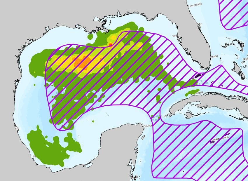
*A majority of the species information on this page comes from the Interna-
Use and Conservation tional Union for Conservation of Nature (IUCN) Red List of Threatened Species.
Threats
Trade Actions EX EW CR EN VU LC
NT
Albacore tuna Bonito Blackfin tuna
Bigeye tuna
Near Threatened Least Concern Least Concern
Sarda sarda Vulnerable
Thunnus alalunga Thunnus atlanticus
Thunnus obesus
Primarily sold as a Food fish, especially important in Important sport fishery in Flor-
canned white meat tuna. An important fishery, pri- ida and the Bahamas.
the Mediterranean and Black seas.
marily sold for sashimi.
Commercial and recre- Commercial and recreational
Commercial and recreational fishing. Commerical and recre- fishing; bycatch of Yellowfin
ational fishing; bycatch Mexico has landed the highest tonnage of ational fishing, bycatch of tuna fisheries. Cuba has ceased
of swordfish fisheries. this species; it represents the second most the Skipjack and Yellowfin reporting landings data for this
captured tuna in Cuba. tuna fishery. species.
It has a total allowable
catch (TAC) of 29,900 It has a total allowable catch A total catch of
No specific measures in
tons for the south Atlan- (TAC) of 29,900 tons for the 85,000 tons has
place.
tic stock.* south Atlantic stock.* been recommended
in the Atlantic.
Bluefin tuna Little tunny Yellowfin tuna
Skipjack tuna
Endangered Least Concern Near Threatened
Euthynnus alletteratus Least Concern
Thunnus thynnus Thunnus albacares
Katsuwonus pelamis
Highly sought-after deli- An important food and Important commercial
cacy for sushi and sashimi economic resources for Primarily sold as canned tuna. species for the raw sashimi
in Asia (WWF, 2018). coastal communities. market (WWF, 2018).
Constitutes 60% of commercial
Commercial and recre- The main species targeted by
Overfishing. tuna catch globally; difficult to
ational fishing; unreported commercial fisheries in the U.S.
assess the impacts of fishing on
Taking Bluefin tuna in the Gulf is or underreporting catches and the only tuna commercial-
populations due to high and vari-
prohibited yearround. ICCAT rec- to ICCAT. ly fished in Mexico.
able productivity.
ommends long-term larval studies No management recom-
in the Gulf to assess the impact of No specific regulations ICCAT has recommended con-
mendations have been made
the Deepwater Horizon Oil Spill. in the Atlantic. servation actions for juveniles.
because of lack of data.
THE NATURE CONSERVANCY | GULF OF MEXICO GULF OF MEXICO TUNA MIGRATIONS 4 THE NATURE CONSERVANCY | GULF OF MEXICO GULF OF MEXICO TUNA MIGRATIONS 5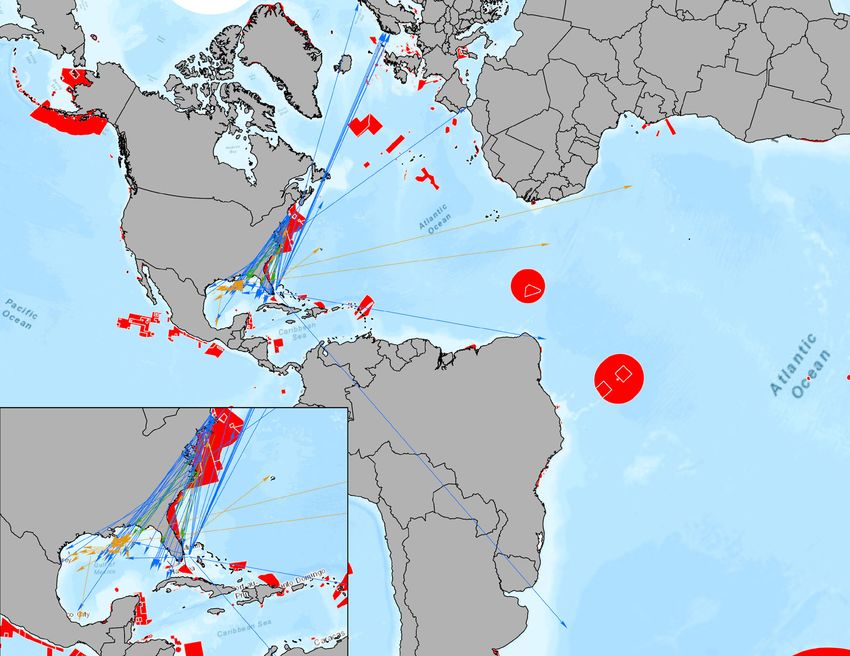
Mapping Tuna Migrations                                                                   Migratory Pathways and
                                                                                             Connectivity
   Scope
                                                                                             Bluefin Tuna Migratory Corridor
   Publicly available spatial data for tunas in the Gulf includes observations,
   tag-recapture, movement, and larvae dispersal data.                                       A vast majority of the satellite telemetry data available for tunas follows blue-
                                                                                             fin tuna. A kernel density analysis in ESRI ArcGIS (Geographic Information Sys-
   Observation data, or occurrence points, comes from a variety of sources. Re-              tem) was used to generate a movement density map from 25 individual tuna
   search institutions and management organizations like NOAA periodically sur-              tracklines in the Gulf that span over 9 years (April 2002 - July 2011). This map
   vey marine life aboard research vessels. Citizen science can provide valuable             (Figure 2) represents the migratory corridor of bluefin tuna in the Gulf of Mex-
   observation information when recorded systematically. Fisheries catch data                ico. The areas of high movement density constitute critical areas for threat
   can also be used as observation data. Observation data reveals how species                abatement to allow endangered bluefin tunas to complete their life cycle. For
   distribute across regions.                                                                example, the area between the Florida Keys and Cuba in the Florida Straight
                                                                                             represents the seasonal pathway of reproductive adults in to the Gulf.
   Telemetry data is generated by placing electronic tags on animals. Some
   tags transmit location information to satellites or antennas whenever the tag             Figure 2. Bluefin tuna migratory corridor. This corridor is
   surfaces. Some connect (‘ping’) with underwater acoustic receivers while                  displayed at 99% density.
   animals travel along their migratory routes. As these tags are still more ex-
   pensive than observation/tag-recapture methods, they are typically used for                                                                                             Movement
                                                                                                                                                                           Density
   protected species such as sea turtles. Not much telemetry data is available
                                                                                                                                                                             High
   for fish. For tuna species, the exception is bluefin tuna, which has been iden-
   tified by the IUCN as endangered and constitutes the most expensive fishery
   in North America. Telemetry data uncovers migratory corridors as it shows
   animal movement along pathways rather than only presence.

   Tag-recapture data is generated when an animal is tagged using a convention-
   al tag (usually made of plastic or metal) when fished recreationally (primarily)
   and recaptured at another time and potentially different location. This tech-
                                                                                                                                                                             Low
   nique is a more economical alternative to electronic methods. Tag-recapture
   data shows migratory connectivity, or which areas are connected by animals
   through the different habitats that they use during their lives.

   Fish larvae data is collected through systematic field surveys. It is available at
   the sampling station level and can be scaled to give a picture of average larval
   abundance seasonally and throughout the Gulf. This information is important
   for conservation of populations as reproductive grounds are especially vulner-
   able to systemic threats (but also devastating oil spill incidents).

   Combining these data types from several resources, the Conservancy has gen-
   erated species distributions and identified critical areas for tuna conservation          Data Sources: Hopkins Marine Station, Stanford University via NOAA’s Animal
                                                                                             Telemetry Network (ATN); NOAA’s Environmental Response Management Appli-
   to guide fisheries policy and management strategies. These areas have been
                                                                                             cation (ERMA).
   identified per species, per season, and overall from best available spatial data
   in the entire Gulf region.

THE NATURE CONSERVANCY | GULF OF MEXICO		 GULF OF MEXICO TUNA MIGRATIONS			6            THE NATURE CONSERVANCY | GULF OF MEXICO		 GULF OF MEXICO TUNA MIGRATIONS			7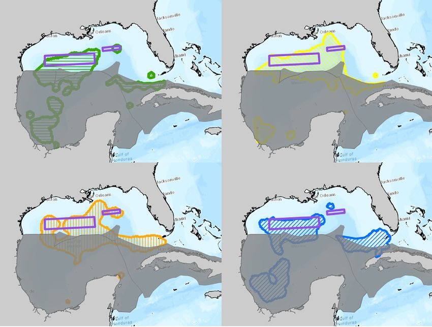
Seasonal Distributions                                                     Figure 4. Yellowfin tuna seasonal distributions. The
                                                                                             distributions are displayed at 99% density.
                  Density maps of tuna observations were generated from occur-
                  rence points collected from scientific organizations and publicly
                  available databases. The yellowfin tuna density map is shown in
                  Figure 3.

                  A convex hull tool was used to first create a spatial range for each
                  species overall and for each species in each season to serve as
                  modeling boundary (XTools Pro). A kernel density analysis was
                  then used to create seasonal distributions for each species.

                  The search radius parameter (Href) in the kernel density analysis
                  for each species was calculated using the Home Range Tools Arc-
                  GIS extension (Rodgers et al. 2015).

                  Figure 3. Yellowfin tuna observation-based distribution in the
                  Gulf vs. the International Union for Conservation of Nature
                  (IUCN) Red List global distribution (Collette et al. 2011). The
                  distribution is displayed at 99% density.
       Density
      High

                                                                                             Density
                                                                                                       Low              High

                                                                                             Observations were split by season to create seasonal density
      Low                                                                                    maps. The seasonal yellowfin tuna density maps are shown in
                                                                                             Figure 4. These maps show the spatial variability of seasonal
                                                                                             distributions and hotspots. These distributions for yellowfin tuna
          IUCN                                                                               (Figures 3-4) complement their previously known global distribu-
   Distribution                                                                              tion (IUCN, Figure 3). The new distribution areas in the southern
                                                                                             Gulf and off the mouth of the Mississippi River delta confirm that
                                                                                             coastal habitats are also important to this species.

THE NATURE CONSERVANCY | GULF OF MEXICO		 GULF OF MEXICO TUNA MIGRATIONS			8             THE NATURE CONSERVANCY | GULF OF MEXICO		 GULF OF MEXICO TUNA MIGRATIONS			9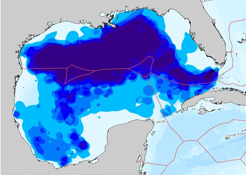
Migratory Connectivity                                                                                         Larvae Analyses                                      Figure 6. SEAMAP station data for
                                                                                                                                                                      bonito, bigeye tuna, and yellowfin
  Marine animals have been historically tagged with plastic or metal tags (not electron-                         The Southeast Area Monitoring and Assess-            tuna. Publicly available larvae data
  ic) by resource managers and researchers looking to answer questions about their                               ment Program (SEAMAP) of the Gulf States             for these species is sparse in the
  movement patterns to enhance their management and conservation. When a tagged                                  Marine Fisheries Commission has been col-            Gulf.
  fish is found by another fisherman or researcher, the original person or organization                          lecting icthyoplankton data through annual
  that tagged the fish is notified via the identification number and contact information on                      surveys in the Gulf of Mexico since 1982.
  the tag. Though the information provided by tag-recapture is not as detailed as that of                        Icthyoplankton are the eggs and larvae of fish.
  electronic tags, this affordable animal tracking method still provides information about                       This data has been collected for seven of the
  species migratory connectivity, survival, and habitat use.                                                     eight tuna species of interest in this report,
                                                                                                                 but some species are better represented in
  Tracklines in Figure 5 connect tag and recapture locations for specific tuna individuals.                      the samples than others (due to a variety of
  These tracklines not only show the directions, times, and distances travelled by specific                      technical issues including natural environ-
  tuna animals over time, but the diversity of habitats that they might have used to mi-                         mental variability and the challenge of small
  grate through the Atlantic Ocean.                                                                              fish larvae identification). Figure 6 shows how
                                                                                                                 sparse larvae data is for bonito, bigeye tuna,
                            Figure 5. Tuna species tag-recapture path lines.                                     and yellowfin tuna. Data is absent for albacore
                                                                                                                 tuna. Figure 7 shows tuna larvae distributions
             Tuna Species                             2.24                                                                                                              Bigeye tuna
                                                     years                                                       in the Gulf for bluefin tuna, little tunny, black-
                                                                                                                                                                        Bonito
         Yellowfin                                                                                               fin tuna, and skipjack tuna using SEAMAP
                                                                                                                                                                        Yellowfin tuna
                                                             1.26                                                station data from 1982 to 2012.
       Little Tunny                                                 yea
                                                                        rs
                                                                                                                 Figure 7. Tuna larvae heat map from 1982-2012 SEAMAP station data.
           Bluefin
                                                                                                                                                                                                  Density
                                                                                                     ears
            Bigeye                                                                             1.61 y
                                                                                                                                                                                                     High
          Blackfin                                                           2.23 year
                                                                                      s

         Protected
             Areas                                                                        1.78 y
                                                                                                ears

                                              1.42 years
                                                                                                                                                                                                     Low

                            3.52 years
                                                                                                  ears
                                                                                            3.73 y

  Tag-recapture data exposes tuna migratory connectivity by showing the habitats con-
  nected by seasonal tuna migrations and by different tuna species. Figure 5 shows that
  several bluefin tuna travelled from the Gulf of Mexico to northern Europe, while a few
  also travelled to South America. Multiple yellowfin tuna traveled towards western Af-
  rica, where they spawn during the winter. Migratory connectivity is important for con-
  servation because these species need to be able to reach different habitats to carry out
  various ecological processes that are critical for their survival and for ecosystem health.

THE NATURE CONSERVANCY | GULF OF MEXICO		 GULF OF MEXICO TUNA MIGRATIONS		                                  10     THE NATURE CONSERVANCY | GULF OF MEXICO		 GULF OF MEXICO TUNA MIGRATIONS		                11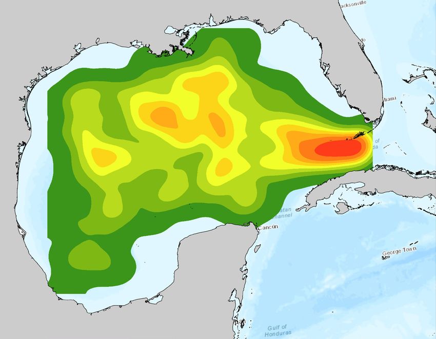
Marxan Conservation Planning Software
   Conservation Portfolio                                                                         Marxan is a conservation planning software that optimizes a set of conservation features or
                                                                                                  targets (e.g., migratory corridors) with costs (e.g., human threats to migration) under vary-
   Critical Areas for Tuna Species                                                                ing scenarios to output critical areas for management (Ball et al. 2009). Each feature can be
                                                                                                  given a specific conservation goal, and boundaries can be used to ensure that these goals
   Density estimates were reclassified in ArcGIS so that any movement density greater             are met within specific sub-regions in the study area. The Conservancy used Marxan in the
   than 1% was reclassified to species presence. This transformed the movement density            Gulf to produce results relevant to tuna fisheries management.
   map into a 99% observation presence and absence data layer.
                                                                                                  The results below in Figure 8 were created using the tuna observation density layers de-
   Each of the eight species layers were then stacked. The resulting seasonal layers show         scribed in the previous section as conservation features, and 100 km2 hexagons spanning the
   an estimation of how many of the studied tuna species (from 0 to 8) are distributed            entire Gulf as planning units. A Marxan scenario was created for each season: Spring, Sum-
   throughout the Gulf.                                                                           mer, Fall, Winter. Conservation targets were scaled based on each species’ IUCN Red List
                                                                                                  Status: Near Threatened (NT) as 20%; Vulnerable (VU) as 30%, Endangered (EN) as 40%,
   These layers provide a visual representation of tuna diversity throughout the Gulf.            and Critically Endangered (CR) as 50%. See pages 4-5 for each tuna species’ IUCN status
   Since they have been generated from observation points rather than telemetry move-             (IUCN 2018).
   ments, they do not constitute migratory corridors. However, since tracking data is rare
   or unavailable for most of these species, these maps provide a strong representation           Seasonal threat layers were generated by aggregating averaged seasonal AIS data from
   of tuna seasonal distributions.                                                                Global Fishing Watch for 2012 to 2017 (Global Fishing Watch 2018) with relevant cumulative
                                                                                                  human impacts layers for 2013 from Halpern et al. (2015). Human impacts layers include
   Dark blue areas in Figure 8 should be considered critical habitat for tunas. These areas       factors such as shipping lanes, pollution, offshore energy activity, invasive species, and fish-
   are further refined using Marxan conservation planning software (results outlined in           eries activities. Existing protected areas were not locked into any Marxan scenario. The three
   red) to consider threats and conservation goals, described in the next section.                EEZs – U.S., Mexico, Cuba – in the Gulf of Mexico were extrapolated manually in ArcMap to
                                                                                                  divide the two International regions equally between the three EEZs. This extended EEZ layer
   It is also important to note that there is some bias in the data, since more data is avail-    was used as modeling strata in the Marxan analysis so that goals set for each conservation
   able in the United States Exclusive Economic Zone (EEZ) than in Mexico or Cuba. This           target would have to be met within each country’s jurisdiction.
   can be seen with the darker blue areas concentrated in the U.S. EEZ.
                                                                                                  The seasonal Marxan analyses were run with and without EEZs as strata; both results were
                                                                                                  then aggregated into the final priority areas shown in Figures 8 a-d. This gives information
     Number of      1   2   3   4    5   6   7   8         Marxan-identified
     Tuna Species                                                                                 on not only the most critical areas in the Gulf overall, but also the most critical areas within
                                                           priority areas for conservation
     Present                                                                                      each country’s EEZ in our final results, reducing errors from geographic bias of data. Multiple
                                                                                                  scenarios were created with varying inputs to identify these most relevant outputs to sup-
     Figure 8. Seasonal Marxan scenarios and important areas for eight tuna                       port fisheries management. The Conservancy has the capability of analyzing new scenarios
     species in the Gulf of Mexico. Left to right: Spring, Summer, Fall, Winter.                  if differing priorities are identified by stakeholders.

THE NATURE CONSERVANCY | GULF OF MEXICO		 GULF OF MEXICO TUNA MIGRATIONS		                   12     THE NATURE CONSERVANCY | GULF OF MEXICO		 GULF OF MEXICO TUNA MIGRATIONS		               13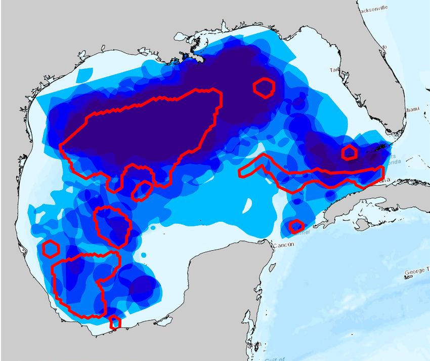
Decision Support Tools

   Tuna Fisheries App                                                                           The regulation and distribution information is location specific and can be
                                                                                                displayed at four different scales: EEZs, a generic 20-km by 20-km grid layer,
   The ‘Tuna Fisheries’ app is hosted within the Conservancy’s online Blueways                  existing managed and protected areas, and offshore energy planning units for
   Conservation Decision Support Tool (maps.bluewaysconservation.org). This                     the U.S. and Mexico. This multi-scale functionality was created by intersecting
   tool allows scientists, resource managers, and decision-makers to systemat-                  these multiple boundaries with individual IUCN species distributions with the
   ically and transparently identify critical areas for migratory tuna, assess how              goal of presenting information in a format relevant to managers across sec-
   effective existing management areas are for tunas, or to manage fishing effort.              tors.

   The app contains spatial information and species facts about tuna distribu-                  Additional layers that can be toggled on per species include aggregated
   tions based on the IUCN Red List species’ data. It also contains condensed                   monthly observation points and essential fish habitats. These layers can be
   location-specific fishing regulation information with links to full data sources             used to guide user selection of areas that meet their specific management
   for more information. Finally, monthly information on migration, spawning,                   interests or to create maps that support decision-making.
   and foraging has been compiled based on best available data.
                                                                                                Figure 10. The Tuna Fisheries app shows the bluefin tuna distribution in the
                                                                                                Gulf within a 20-km by 20-km grid. The user has selected a block shown
   Figure 9. The Tuna Fisheries app hosted within the Blueways Conservation                     in yellow, giving location-specific regulations information on the left. The
   Decision Support Tool displays the number of tuna species within existing                    IUCN species fact sheet shows that bluefin tuna especially need protection
   managed and protected areas based on IUCN species distributions. This                        in the Gulf of Mexico as spawning adults. Above, the chart shows that tuna
   tool can be found at maps.bluewaysconservation.org.                                          spawn from April through June.

THE NATURE CONSERVANCY | GULF OF MEXICO		 GULF OF MEXICO TUNA MIGRATIONS		            14   THE NATURE CONSERVANCY | GULF OF MEXICO		 GULF OF MEXICO TUNA MIGRATIONS		             15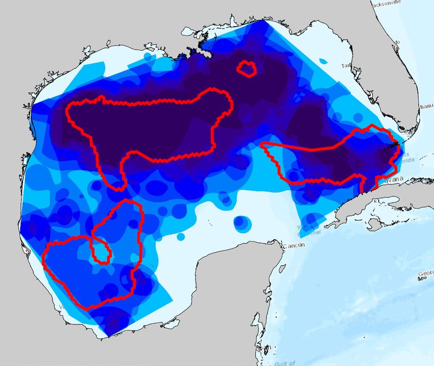
Figure 11. Gulf of Mexico tuna fishing regulations summary.

United               Texas                                Louisiana                            Mississippi                            Alabama                    Florida                        US Federal & International Waters

States
Species              Bag          Min    Season Bag                    Min    Season Bag                    Min    Season             Bag     Min    Season      Bag Limit   Min      Season    Bag       Min       Season
                     Limit        Length        Limit                  Length        Limit                  Length                    Limit   Length                         Length             Limit     Length
Albacore             none         none        year-       none         none        year-       none         none        year-         none    none     year-     none        none     year-     none      none      year-round
Tuna                                          round                                round                                round                          round                          round
Bigeye Tuna          none         none        year-       none         27”         year-       none         27”CFL year-              none    27”      year-     none        27”      year-     none      27” CFL year-round
                                              round                    CFL**       round                           round                      CFL      round                 CFL      round
Blackfin Tuna none                none        year-       none         none        year-       none         none        year-         none    none     year-     greater of none      year-     none      none      year-round
                                              round                                round                                round                          round     2 fish or            round
                                                                                                                                                                 100lb/day
Bluefin Tuna*                                 none        1/      73”              none                                 none                           none      1/vessel/ 73”        none      1/        73” CFL year-round
                                                          vessel/ CFL                                                                                            year*      CFL                 vessel/
                                                          year*                                                                                                                                 year*
Bonito               none         none        year-       none    none             year-       none         none        year-         none    none     year-     greater of none      year-     none      none      year-round
                                              round                                round                                round                          round     2 fish or            round
                                                                                                                                                                 100lb/day
Little Tunny         none         none        year-       none         none        year-       none         none        year-         none    none     year-     greater of none      year-     none      none      year-round
                                              round                                round                                round                          round     2 fish or            round
                                                                                                                                                                 100lb/day
Skipjack             none         none        year-       none         none        year-       none         none        year-                          year-     none       none      year-     none      none      year-round
Tuna                                          round                                round                                round                          round                          round
Yellowfin            none         none        year-       3/per-       27”CFL year-            3/per-       27”CFL year-              none    27” CFL year-      none        none     year-     3/per-    27” CFL year-round
Tuna                                          round       son/                round            son/                round                              round                           round     son/day
                                                          day                                  day
See data sources on page 25 for a full list of references.
*Targeting bluefin tuna in the Gulf of Mexico is prohibited year-round. Highly Migratory Species Angling or Charter/Headboat
                                                                                                                                      Mexico
permit holders may retain one “trophy” bluefin tuna (greater than 73” CFL) per vessel per year from the Gulf of Mexico if it is       Sportfishing in Mexico requires a sportfishing license which can be obtained at: www.sport-
caught incidentally while targeting other species, provided the Gulf of Mexico “trophy” category subquota is still available at the
time of harvest. More information about is available at: www.hmspermits.noaa.gov. **[CFL = curved fork length].                       fishinginmexico.com/licences/
                                                                                                                                      In ocean waters and estuaries, the limit is a total of 10 fish per person per day with no more
Fishing Regulations Table                                                                                                             than 5 catches of a single species. There are some exceptions to this rule:
                                                                                                                                      • Only 1 specimen of billfish, shark, or giant seabass (Stereolepis gigas) is allowed per day
Fishing regulations for the Gulf are difficult to navigate, especially those recreational. This is                                        and counts as 5 towards the overall 10 fish limit.
due to regulatory differences between the five states in the U.S., within the three countries                                         • Only 2 specimens of Dorado, Roosterfish, Shad, Tarpon, Gulf Grouper (Mycyteroperca
in the Gulf, and in the two international zones.                                                                                          jordani), or Bluefin Tuna (Thunnus orientals) are allowed per day and count as 5 toward
                                                                                                                                          the overall 10 fish limit.
The fishing regulations summary in Figure 11 compiles regulations for all three countries and                                         • The capture limit for squid is 5 samples per fisherman per day.
international waters based on best available information. The U.S. regulations were collected
by state and standardized into a relevant format (Texas Parks and Wildlife 2017, Louisiana
Wildlife and Fisheries 2017, Outdoor Alabama 2017, Florida Fish and Wildlife Conservation                                             Cuba
Commission 2017, NMFS Atlantic Tunas Program 2015). Information for Mexico, and espe-
                                                                                                                                      Sport fishing in Cuba requires a permit or fishing license for any method of fishing. Permits
cially Cuba, however, is more difficult to condense into a single format (Secretaría de Agri-
                                                                                                                                      can be obtained by presenting a passport.
cultura, Ganadería, Desarrollo Rural, Pesca y Alimentación 2017, TripCuba.org 2017).

   THE NATURE CONSERVANCY | GULF OF MEXICO		 GULF OF MEXICO TUNA MIGRATIONS		                                                16         THE NATURE CONSERVANCY | GULF OF MEXICO		 GULF OF MEXICO TUNA MIGRATIONS		               17
Key Findings
The seasonal Marxan analyses in Figure 13 have identified crit-
ical areas for migratory tunas in the Gulf of Mexico. While less
than 2% of these areas are protected, effective management
and Limitations
is more relevant for these commercially valuable species than
protection. Current fisheries management is insufficient; options
such as seasonal limitations to fishing use should be explored
alongside stakeholders to address these gaps.
The Conservancy has created as close to a map of tuna migra-
Figure 13. Marxan seasonal results and Gulf of Mexico protected
tory “blueways” as possible given the publicly available data at
areas.
this time. Figure 12 shows the number of tuna species (out of
the 8 in this study) present throughout the Gulf based on obser- Spring
vational density maps. This map can serve as a guide for tuna
fisheries management in conjunction with the seasonal Marxan Summer
results (Figure 8). However, the data bias between countries
can be clearly seen in this blueways map. There are more spe- Fall
cies shown to be present in the U.S. EEZ than in Mexico or Cuba,
likely due to increased survey effort rather than higher species Winter
presence.
Figure 12. Tuna species distributions based on
observational data. Protected
Number
Areas
of Tuna
Species
1
2
3
4
5
6
7 In the seasonal Marxan scenarios presented in this report,
bluefin tuna is given the most weight with a goal of 50% con-
8 servation of its distribution. This is because each species was
Exclusive weighted based on its IUCN conservation status, and bluefin is
Economic the only tuna species in this analysis classified as endangered
Zones (EEZ)
(IUCN 2018). In 2014, NOAA identified two regions in the Gulf
as critical for improving management of bluefin tuna under
Critical areas for tunas vary greatly between seasons, as evi- Amendment 7 to the 2006 Consolidated Highly Migratory Spe-
denced by the Marxan results in Figure 13. Seasonality is im- cies Fishery Management Plan (NMFS, NOAA 2014). In these
portant to consider in management decisions. Tuna species areas, measures were enacted to prevent overfishing and re-
spawn, migrate, and forage seasonally, and fishing effort varies build stocks, minimize bycatch, reduce dead discards, and im-
throughout the year. Managing these activities compatibly re- prove the scope and quality of catch data (NMFS, NOAA 2014).
quires spatial and temporal optimization. These Marxan results The seasonal Marxan results support that NOAA’s bluefin tuna
provide a guide for fisheries managers aiming to balance eco- management areas are critical for tunas throughout all seasons
nomic productivity with population survival rates. (Figure 14).
THE NATURE CONSERVANCY | GULF OF MEXICO GULF OF MEXICO TUNA MIGRATIONS 18 THE NATURE CONSERVANCY | GULF OF MEXICO GULF OF MEXICO TUNA MIGRATIONS 19Figure 14. NOAA bluefin tuna management areas (Amendment Figure 15. Tuna species observational distributions vs. the
7 to the 2006 Consolidated Highly Migratory Species Fishery International Union for Conservation of Nature Red List distributions
Management Plan) over seasonal Marxan results. (IUCN 2018).
Spring
Density
Summer High
Fall
IUCN
Winter Distribution Low
NOAA
Bluefin Tuna
Management
Zones
Discrepancies in available scientific information for deci-
sion-making have also been identified that could have moni-
toring and conservation implications for important commercial
tuna species. There are some substantial differences between
the International Union for Conservation of Nature Red List
available species distributions and the observation density dis- Figure 16. Tuna species migratory timing.
tribution maps created in this project (IUCN 2018). Particularly,
Figure 15 shows substantial underestimations in the IUCN layers Jan Feb Mar Apr May Jun Jul Aug Sep Oct Nov Dec
where there appear to be dense observations for bluefin tuna, Albacore tuna
bonito, and yellowfin tuna.
Bluefin tuna
Bonito
Detailed migratory timing information was difficult to compile
Bigeye tuna
for these species. A chart of available information is shown in
Figure 16, as available in the “Tuna Fisheries” app in the Con- Blackfin tuna
servancy’s Blueways Conservation Decision Support Tool. This Little tunny
information will need to be refined over time as more research
and synthesis become available. Skipjack tuna
Yellowfin tuna
In foraging areas Spawning Migration period
THE NATURE CONSERVANCY | GULF OF MEXICO GULF OF MEXICO TUNA MIGRATIONS 20 THE NATURE CONSERVANCY | GULF OF MEXICO GULF OF MEXICO TUNA MIGRATIONS 21The Way Forward
Reduce mortality of bluefin tuna by enforcing a firm limit on in-
cidental catch for the surface long-line fleet, including the im-
provement of monitoring of the surface long-line fleet to ensure
compliance with annual limit (ICAAT 2010a).
Support the transition of poorly selective long-line to more se-
Managing highly migratory tunas in the Gulf is a complex, multi-fac- lective fishing gear, such as green-stick, to harvest bigeye, alba-
eted task. Fisheries managers are constantly challenged to sustain- core, yellowfin, and skipjack tunas (NMFS; 50 CFR § 635.2).
ably balance the economic productivity of the fishery, recreational
fishery needs, and other ocean uses with the critical goal of species
Continue monitoring yellowfin tuna fishing effort and bycatch
survival.
levels with observer programs in Mexico (DOF 2015).
This report is intended to guide managers in these complex tasks,
but much more information is needed to achieve this balance. Ad- Develop a complete stock assessment for yellowfin tuna to iden-
ditional enhancements in tuna research, fisheries management, and tify biological points of reference and sustainable management
policy are needed to improve decision-making around tuna fisher- practices in Mexico (DOF 2015, Ramirez-Lopez 2017).
ies and so to strengthen resilience and sustainability. Building from
existing science and management plans, the Conservancy suggests
Invest in data reconciliation and data synthesis to significantly
the following enhancements:
improve the knowledge of total catch, catch composition, effort,
and spatial distribution of the major fisheries in the Gulf region
Expand research on the influence of pelagic habitat on other (ICAAT 2010b).
species beyond bluefin tuna and yellowfin tuna (Teo et al. 2007,
Teo and Block 2010, Incardona et al. 2014) and evaluate the
Create a shared vision across the international scientific and
importance of different habitat types for managed populations
management community that will support range-wide assess-
(NMFS 2013, 2018).
ments of shared stocks in the Gulf of Mexico, including the
development of collaborative monitoring and assessment strat-
Conduct histological studies of gonads and larvae distribution to
egies for data-poor situations (NMFS 2012).
assess bluefin tuna spawning areas in Mexico (Abad-Uribarren
et al. 2014) and Cuba (Muhling et. al 2010).
Develop collaborations towards sustainable fisheries manage-
Improve the understanding of factors affecting recruitment ment between resource managers, scientists, and fishing com-
success and long-term sustainability of the fisheries across their munity to improve the data upon which management decisions
full range by expanding large-scale conventional, electronic, and are made and integrate socio-economic aspects of the fishing
genetic tagging experiments to estimate the movement, abun- industry into the management process.
dance, and mortality of the eastern or western stocks (ICAAT
2010a), including not only bluefin, but other tuna species rele-
vant to fisheries in the Gulf. Moving forward, The Nature Conservancy will strive to update this
information and provide it to fisheries managers through interac-
tive tools such as the Blueways Conservation Decision Support Tool.
Strengthen the science needed to implement ecosystem-based
Feedback from managers is vital for improving these platforms.
fisheries management of tuna (NMFS 2018) that balances en-
vironmental, economic, and social objectives (Marshall et al.
2018). Implement ecosystem-level planning to replace existing
single-stock assessments with a systematic approach to fisher-
ies management that contributes to the resilience and sustain-
ability of the ecosystem (NMFS 2013).
THE NATURE CONSERVANCY | GULF OF MEXICO GULF OF MEXICO TUNA MIGRATIONS 22 THE NATURE CONSERVANCY | GULF OF MEXICO GULF OF MEXICO TUNA MIGRATIONS 23Satellite Tracking Data:
Block, Barbara. Hopkins Marine Station, Stanford University. ATN IOOS. 2017. Web Application: Animal Telemetry Network, Integrated
References
Ocean Observing System, National Oceanic and Atmospheric Administration (NOAA). Retrieved: April 20, 2017, from http://oceanview.
pfeg.noaa.gov/ATN/
Environmental Response Management Application (ERMA). Web application. Gulf of Mexico. NRDA Workgroup Data. National Oceanic
and Atmospheric Administration, 2014. Web. 13 Apr. 2017. http://response.restoration.noaa.gov/erma.
Observation Data:
Abad-Uribarren, A. 2010. Distribución y preferencias oceanográficas del atún aleta azul Thunnus thynnus (Linnaeus, 1758) en el Golfo de
México. Tesis de Maestría en Ecología y Pesquerías. Universidad Veracruzana. Veracruz, 93 pp.
Abad-Uribarren, A., C. Meiners, K. Ramirez-Lopez, and S. Ortega-Garcia. 2014. Dinámica temporal de la captura incidental de CONABIO. 2017. Geoportal del Sistema Nacional de Información sobre Biodiversidad. Comisión Nacional para el Conocimiento y Uso de la
atún aleta azul (thunnus thynnus) y su relación con la variabilidad ambiental en aguas Mexicanas del Golfo de México. Col. Vol. Biodiversidad (CONABIO). México, D.F.
Sci. Pap. ICCAT, 70 (2): 684-698. Environmental Response Management Application (ERMA). Web application. Gulf of Mexico. NRDA Workgroup Data. National Oceanic
Brenner, J., C. Voight, and D. Mehlman. 2016. Migratory Species in the Gulf of Mexico Large Marine Ecosystem: Pathways, Threats and Atmospheric Administration (NOAA), 2014. Web. 13 Apr. 2017. http://response.restoration.noaa.gov/erma.
and Conservation. The Nature Conservancy, Arlington, 93 pp. FIDEMAR. 2018. Reporte 2017. Fideicomiso de Investigación para el Desarrollo del Programa Nacional de Aprovechamiento del Atún y
Collette, B., Acero, A., Amorim, A.F., Boustany, A., Canales Ramirez, C., Cardenas, G., Carpenter, K.E., Chang, S.-K., de Oliveira Protección de Delfines y otros en torno a especies Acuáticas Protegidas (FIDEMAR). Ensenada.
Leite Jr., N., Di Natale, A., Die, D., Fox, W., Fredou, F.L., Graves, J., Guzman-Mora, A., Viera Hazin, F.H., Hinton, M., Juan Jor- Garrison, L. 2013. SEFSC GoMex Oceanic 1993 (S). Data downloaded from OBIS-SEAMAP (http://seamap.
da, M., Minte Vera, C., Miyabe, N., Montano Cruz, R., Masuti, E., Nelson, R., Oxenford, H., Restrepo, V., Salas, E., Schaefer, K., env.duke.edu/dataset/17) on 2016-07-07.
Schratwieser, J., Serra, R., Sun, C., Teixeira Lessa, R.P., Pires Ferreira Travassos, P.E., Uozumi, Y. & Yanez, E. 2011. Thunnus alb- Garrison, L. 2013. SEFSC GoMex Oceanic 2000. Data downloaded from OBIS-SEAMAP (http://seamap.env.
acares. The IUCN Red List of Threatened Species 2011: e.T21857A9327139. http://dx.doi.org/10.2305/IUCN.UK.2011-2.RLTS. duke.edu/dataset/21) on 2016-07-07.
T21857A9327139.en. Downloaded on 23 July 2018. GBIF: The Global Biodiversity Information Facility (2018). Available from https://www.gbif.org/.
DOF. 2015. Acuerdo por el que se da a conocer el plan de manejo pesquero de atún aleta amarilla (Thunnus albacares) en el Golfo NMFS NOAA. “A Guide to Tunas of the Western Atlantic Ocean.” 2009. http://www.nmfs.noaa.gov/sfa/
de México. Diario Oficial de la Federación (DOF), Secretaría de Agricultura, Ganadería, Desarrollo Rural, Pesca y Alimentación. hms/compliance/regulations/tuna_guide_2009.pdf
Mexico City, 35 pp. NMFS. unpublished data. Gulf of Mexico historical fisheries survey database. National Marine Fisheries Ser-
Harford, W.J., Karnauskas, M., Walter, J.F. and Liu, H., 2017. Non-parametric modeling reveals environmental effects on bluefin vice (NMFS), NOAA. Pascagoula.
tuna recruitment in Atlantic, Pacific, and Southern Oceans. Fisheries Oceanography, 26(4), pp.396-412. OBIS. (2018) Ocean Biogeographic Information System. Intergovernmental Oceanographic Commission of
ICAAT. 2010a. Report of the 2010 Atlantic bluefin tuna stock assessment. International Commission for the Conservation of Atlan- UNESCO. www.iobis.org.
tic Tunas (ICAAT). Madrid.
ICAAT. 2010b. Bluefin tuna research priorities and potential costs. Doc. No. STF-207/2008. International Commission for the Con- Tag-Recapture Data:
servation of Atlantic Tunas (ICAAT). 4 pp. NMFS. 2017. Cooperative Tagging Center (CTC). National Marine Fisheries Service (NMFS), National Ocean-
Incardona, J.P., et al. 2014. Deepwater Horizon crude oil impacts the developing hearts of large predatory pelagic fish. PNAS ic and Atmospheric Administration (NOAA). Miami.
201320950. Threats:
IUCN 2018. The IUCN Red List of Threatened Species. Version 2018-1. . Downloaded on 05 July 2018. Halpern, Benjamin, Melanie Frazier, John Potapenko, Kenneth Casey, Kellee Koenig, et al. 2015. Cumulative human impacts: raw stressor
Levesque, J. C. 2011. Commercial fisheries in the northwestern Gulf of Mexico: possible implications for conservation manage- data (2008 and 2013). urn:node:KNB. doi:10.5063/F1S180FS.
ment at the Flower Garden Banks National Marine Sanctuary. – ICES Journal of Marine Science, 68: 2175–2190. Global Fishing Watch. 2018. Accessed on November 7, 2017. www.globalfishingwatch.org
Marshall, K.N., et al. 2018. Ecosystem-based fisheries management for social–ecological systems: Renewing the focus in the Unit- Larvae Data:
ed States with next generation fishery ecosystem plans. Conservation letters 11(1): 1–7. SEAMAP. 2017. Ichthyoplankton database. Southeast Area Monitoring and
NMFS. 2018. Draft Gulf of Mexico ecosystem-based fishery management road map implementation plan. National Marine Fisher- Assessment Program (SEAMAP). Gulf States Marine Fisheries Commission.
ies Service (NMFS), National Oceanic and Atmospheric Administration. 16 pp. Ocean Springs. https://seamap.gsmfc.org/datarequests/index.php
Muhling, B.A., Lamkin, J.T., Quattro, J.M., Smith, R.H., Roberts, M.A., Roffer, M.A., Ramirez, K, 2010. Collection of Larval Bluefin
Tuna (Thunnus Thynnus) Outside Documented Western Atlantic Spawning Grounds. Bulletin of Marine Science, Volume 87, Num- Fishing Regulations Table:
ber 3, July 2011, pp. 687-694(8). Texas Parks and Wildlife. 2017. Regulations. https://tpwd.texas.gov/regula-
Muhling, B.A., Roffer, M.A., Lamkin, J.T., Ingram Jr, G.W., Upton, M.A., Gawlikowski, G., Muller-Karger, F., Habtes, S. and Richards, tions/
W.J., 2012. Overlap between Atlantic bluefin tuna spawning grounds and observed Deepwater Horizon surface oil in the northern Louisiana Wildlife and Fisheries. 2017. Fishing Regulations. www.wlf.louisiana.
Gulf of Mexico. Marine pollution bulletin, 64(4), pp.679-687. gov/fishing/regulations
NMFS. 2013. Southeast Fisheries Science Center science plan. National Marine Fisheries Service (NMFS), National Oceanic and Mississippi Wildlife, Fisheries, and Parks. 2017. Fishing and Boating. www.
Atmospheric Administration. 25 pp. mdwfp.com
NMFS. 2012. NOAA Fisheries International Science Strategy. National Marine Fisheries Service (NMFS), National Oceanic and Outdoor Alabama. 2017. Saltwater Recreational Size and Creel Limits. https://
Atmospheric Administration. 24 pp. www.outdooralabama.com/fishing/saltwater-recreational-size-creel-limits
NOAA Fisheries. 2006. Final Consolidated Atlantic Highly Migratory Species Fishery Management Plan. https://www.fisheries. Florida Fish and Wildlife Conservation Commission. 2017. Saltwater Fishing
noaa.gov/management-plan/consolidated-atlantic-highly-migratory-species-management-plan Regulations. http://myfwc.com/fishing/saltwater/recreational/
Ramirez-Lopez, K. 2017. Indicadores biológico-pesqueros en la pesquería de atún con palangre en el Golfo de México. El Vigia NMFS Atlantic Tunas Program, NOAA. 2015. https://hmspermits.noaa.gov/other/tunas%20regulations%20brochure%20-%20final%20
22(45): 15-18. bft%20quota%20rule.pdf
Rodgers, A.R., J.G. Kie, D. Wright, H.L. Beyer, and A.P. Carr. 2015. HRT: Home Range Tools for ArcGIS. Version 2.0. Ontario Ministry Secretaría de Agricultura, Ganadería, Desarrollo Rural, Pesca y Alimentación. 2017. http://www.sportfishinginmexico.com/licences/
of Natural Resources and Forestry, Centre for Northern Forest Ecosystem Research, Thunder Bay, Ontario, Canada. TripCuba.org. 2017. Fishing in Cuba. https://www.tripcuba.org/fishing-in-cuba
Steven L. H. Teo, Andre M. Boustany, and Barbara A. Block. 2007. Oceanographic preferences of Atlantic bluefin tuna, Thunnus Management Areas:
thynnus, on their Gulf of Mexico breeding grounds. Mar Biol 152:1105–1119. NMFS, NOAA. 2014. Amendment 7 to the 2006 Consolidated Highly Migratory Species Fishery Management Plan. https://www.gpo.gov/
Teo SLH, Block BA (2010) Comparative Influence of Ocean Conditions on Yellowfin and Atlantic Bluefin Tuna Catch from Longlines fdsys/pkg/FR-2014-12-02/pdf/2014-28064.pdf
in the Gulf of Mexico. PLoS ONE 5(5): e10756. Comisión Nacional de Áreas Naturales Protegidas (CONANP), Dirección de Evaluación y Seguimiento, Subdirección Encargada de la Coor-
United Nations. 2017. On World Tuna Day, UN cites importance of sustainably managed fish stocks in achieving 2030 agenda. dinación de Geomática. 2017. Sistema Nacional de Áreas Protegidas (SINAP). http://www.conabio.gob.mx/informacion/gis
https://www.un.org/sustainabledevelopment/blog/2017/05/on-world-tuna-day-un-cites-importance-of-sustainably-managed- DOF. 2012. Actualización de la Carta Nacional Pesquera de la Secretaria de Agricultura, Ganadería, Desarrollo Rural, Pesca y Alimentación.
fish-stocks-in-achieving-2030-agenda/ Diario Oficial de la Federación, 24 Agosto. México D.F., 236 pp.
WWF (World Wildlife Fund). 2018. Species: why they matter. https://www.worldwildlife.org/species Essential Fish Habitats. Atlantic Highly Migratory Species. National Oceanic and Atmospheric Administration (NOAA). https://www.habi-
Sources
tat.noaa.gov/protection/efh/efhmapper/
Highly Migratory Species. National Marine Fisheries Service (NMFS). National Oceanic and Atmospheric Administration (NOAA).
The IUCN Red List of Threatened Species. Version 2017-3. www.iucnredlist.org. Downloaded 2018.
Lorenzo, Carlos. 2013. El Centro Nacional de Áreas Protegidas (CNAP).
Software: NOAA Marine Protected Areas Center in joint effort with the US Department of the Interior. MarineCadastre.gov. MPA Inventory – MPAs by
Fishing Restriction. Retrieved May 23, 2017 from marinecadastre.gov/data.
Sanchez, Amilcar Mitjans. 2017. Estado actual de la pesqueria commercial de atunes en el occidente de Cuba. Centro de Investigaciones
Ball, I.R., H.P. Possingham, and M. Watts. 2009. Marxan and relatives: Software for spatial conservation prioritisation. Chapter Marinas, Universidad de la Habana, 51 pp.
14: Pages 185-195 in Spatial conservation prioritisation: Quantitative methods and computational tools. Eds Moilanen, A., K.A. World Database on Protected Areas (WDPA). International Union for the Conservation of Nature (IUCN). http://protectedplanet.net/
Wilson, and H.P. Possingham. Oxford University Press, Oxford, UK.
ESRI 2015. ArcGIS Desktop: Release 10.3.1. Redlands, CA: Environmental Systems Research Institute. ArcGIS Maps Service Layer Credits:
XTools Pro for ArcGIS. Version 17.0.2734.0. XTools Pro, Inc. Santa Clara, California, United States of America. Esri, HERE, Garmin, Intermap, increment P Corp., GEBCO, USGS, FAO, NPS, NRCAN, GeoBase, IGN, Kadaster NL, Ordnance Survey, Esri
Japan, METI, Esri China (Hong Kong), swisstopo, ©OpenStreetMap contributors, and the GIS User Community
THE NATURE CONSERVANCY | GULF OF MEXICO GULF OF MEXICO TUNA MIGRATIONS 24 PHOTO © KEVIN ARNOLDJorge Brenner, Associate Director of Marine Science and Fisheries, Texas Chapter
Valerie Pietsch McNulty, Marine GIS Manager, Texas Chapter
migratoryblueways.org | maps.bluewaysconservation.org
JORGE BRENNER | (281) 407-3252 | JBRENNER@TNC.ORG | NATURE.ORG
1800 AUGUSTA DRIVE, SUITE 240 | HOUSTON, TEXAS 77057
PHOTO © JASON HOUSTONYou can also read