Quick response report: Tathra bushfires Mapping the area of Tathra fires to study how Mechanical Fuel Load Reduction can save houses
←
→
Page content transcription
If your browser does not render page correctly, please read the page content below
Quick response report: Tathra bushfires
Mapping the area of Tathra fires to study how Mechanical
Fuel Load Reduction can save houses

Presenters Name
Muhammad Asim Mumtaz, Alexey A. Voinov, & Babak Abedin
University of Technology Sydney (UTS), Faculty of Engineering & IT
Version         Release history                                    Date

    1.0             Initial release of document                        19/05/2018

    All material in this document, except as identified below, is licensed under the
    Creative Commons Attribution-Non-Commercial 4.0 International Licence.

    Material not licensed under the Creative Commons licence:

          •     Department of Industry, Innovation and Science logo

          •     Cooperative Research Centres Programme logo

          •     Bushfire and Natural Hazards CRC logo

          •     All photographs, graphics and figures

    All content not licenced under the Creative Commons licence is all rights
    reserved. Permission must be sought from the copyright owner to use this
    material.

    Disclaimer:
    University of Technology Sydney (UTS) and the Bushfire and Natural Hazards CRC
    advise that the information contained in this publication comprises general
    statements based on scientific research. The reader is advised and needs to be
    aware that such information may be incomplete or unable to be used in any
    specific situation. No reliance or actions must therefore be made on that
    information without seeking prior expert professional, scientific and technical
    advice. To the extent permitted by law, University of Technology Sydney (UTS)
    and the Bushfire and Natural Hazards CRC (including its employees and
    consultants) exclude all liability to any person for any consequences, including
    but not limited to all losses, damages, costs, expenses and any other
    compensation, arising directly or indirectly from using this publication (in part or
    in whole) and any information or material contained in it.

    Publisher:
    Bushfire and Natural Hazards CRC

    ISBN: 0 00000 000 0

    May 2018

1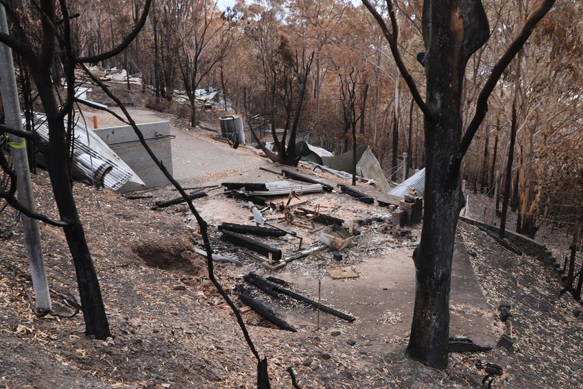
CONTENTS
ABSTRACT ............................................................................................................................................ 3

INTRODUCTION .................................................................................................................................. 4

BACKGROUND ................................................................................................................................... 6

MECHANICAL FUEL LOAD REDUCTION ....................................................................................... 8
MECHANICAL THINNING: A CASE STUDY .................................................................................... 9

RESEARCH METHODS ....................................................................................................................... 12

FINDINGS........................................................................................................................................... 13

MAPPING TATHRA FIRES USING GIS TECHNOLOGY. ................................................................. 13
THOMSON DRIVE PROPERTIES.................................................................................................. 13
TATHRA PROPERTIES ................................................................................................................ 14
MAPPING TATHRA REGION FOR MFLR. ................................................................................... 15

DISCUSSION ...................................................................................................................................... 19

CONCLUSION AND FUTURE RECOMMENDATIONS ..................................................................... 20

REFERENCES ...................................................................................................................................... 21

2
ABSTRACT

Australia is one of the most fire prone continents in the world. The driest winter of 2017 lead to
high forest fuel accumulation in Far South Coast (FSC) NSW, and resulted in a series of bushfires
in that region. Among them, the worst bushfire occurred on 18th March 2018, known as “Tathra
bushfire”, or “Reedy Swamp Fire” according to RFS. It started from the bank of Bega River next
to Thomson drive area and then spread down towards Tathra. The speed and ferocity of bushfire
did not let residents defend their homes. Many residents fled their homes and sought refuge at
Bega evacuation centre. Although most of the houses were saved with the help of water bombing
and volunteer RFS crews almost 1/5 of houses were damaged or destroyed.

The purpose of this “Quick Response” project was to explore the impacts of Tathra bushfires and
map the bushfire affected area to understand whether Mechanical Fuel Load Reduction (MFLR)
could have diminished the risks of property losses and fire spread, if it was used. Mapping was
done using a GIS app and coordinates of each destroyed property were sampled in QGIS. This
report focuses on the extent to which MFLR implementation with HRB in Tathra might provide
an alternative to help saving houses in the future. Our analysis consists of a number of factors
including implementation of MFLR, mapping of Tathra region, access options, weather
conditions of the area, public perceptions, fire behaviour and future recommendations.

We have also used this visit as an opportunity to interview local residents to provide data for the
on-going research at UTS on public perceptions of various hazard reduction techniques, with the
results to be further analysed and reported elsewhere.

3
INTRODUCTION
This Quick response BFCRC funded research was conducted as part of a UTS sponsored Blue
Sky Research Project. The UTS project explores alternatives for hazard reduction burning and
social attitudes and preferences regarding these alternatives. We hypothesize that in some cases
biomass may be collected for bioenergy production. This should also reduce impacts on air quality
and improve human health and wellbeing. In most cases, bioenergy production and other
alternatives are assessed with regard to economics, health, ecological, and fire risk reduction
impacts. In the UTS project, in addition, we are exploring how social media can be used to
understand public preferences and perceptions on these issues and to explore ways of educating
people about the alternatives. In this joint project with BFCRC we are also to focus on an area
recently exposed to fire to see whether there has been a possibility of implementing Mechanical
Fuel Load Reduction (MFLR) for bioenergy production there. The study delivers key findings on
bushfire managements and will be used to provide more effective bushfire management
information to land managers, RFS and researchers. We also used this opportunity to learn about
local residents’ perception to fuel load strategies and fire warnings.

Extreme weather and natural disasters, i.e. cyclones, bushfires, floods and earthquakes are
common in Australia. Australia is also one of the most fire prone countries/continents in the world
and bushfires are the most frequent natural hazards in Australia. Bushfires are an important part
of Australian ecology especially in eucalypt forests. Australia has almost 125 million hectares of
forests which cover around 16% of its land area or 3% of the world forest area (ABARE 2013).
In 2006-2011, almost 31.2% of the Australian forests were exposed to fires (ASFR 2013). Due to
climate change, occurrence of bushfires has been increasing at an alarming rate of more than 40%
annually, over the last five years (Dutta et al. 2016). Fires are becoming a growing concern due
to climatic conditions which impose more threat of frequent wildfire to dry Australian forests.
Millions of dollars are spent every year to control and recover from wildfires. Although fires play
an important role in maintaining ecological integrity in many Australian ecosystems, but bushfires
also pose a risk to human lives, property and economy. These bushfire threats can be reduced
using fuel reduction techniques.

 The primary fuel reduction technique is Hazard Reduction Burning (HRB), also known as
prescribed burning, or controlled burning. It has been used as a hazard reduction method in
Australia for many years. It is a cheap and widely used method to reduce the risk from bushfires.
Australian Bushfire Management (AFM) policy applies prescribed burning in cooler months or
off the season to reduce forest fuel and save properties from wildfires (Penman et al., 2008;
rfs.nsw.gov.au, 2018). Prescribed burning may have many adverse effects including health
problems, risk of fire escape, impaired visibility, water quality, ash deposits. They may affect
wildlife and plants regeneration or reproduction, especially when administered at a wrong time,
or with incorrect frequency. There are also high economic costs associated with conducting HRB.

MFLR is another tool for reduction of forest fuel load. Using MFLR, we can address risks and
concerns associated with HRB as well as extract some revenue from the process if collected
biomass is used energy production or other commercial purposes. In USA, large areas are already
managed using MFLR to control bushfires and 40% of the cost is covered by selling timber
(Grindlay 2015). Researchers and scientists are working on experimental trials and effectiveness
of MFLR in Australian forests under National Bushfire Mitigation Programme (NBFP).

4
FSC region is historically affected by large bushfires. Our research trip was initiated after a high
unexpected bushfire blaze (more than 1000-hectare fire) hit Tathra town. According to RFS, 93
fuel reduction activities in form of prescribed burnings took place in the area from 2006 to 2017.
Despite that, Tathra fire was so intense and behaved so sporadically that it burnt 69 houses
completely and had high financial and social impacts. Fire was driven by wind and embers flew
several hundred meters from the boundary of forest fire. This suggests that prescribed burning
alone may not be always enough especially since it is not possible in areas in close proximity to
properties. We need more effective fuel reduction strategy.

Tathra has a significant forest area (with high loads of fuel) which is close to accessible roads and
private properties. This makes Tathra a promising area to implement MFLR. Using Tathra fires
as a case study, this research trip evaluates the potential of MFLR in Tathra area. In this report
we describe the results of the trip, map the study area of Tathra, and explore how MFLR along
with prescribed burning could save houses (in the future) in Tathra, NSW.

5
BACKGROUND
Tathra is a small town on the Sapphire Coast in the Far South Coast region, New South Wales,
Australia. It has an estimated population of 1600 residents. The dry winter of 2017 (driest year
since 20061) increased the risk of bushfire in that region. The fire started on March 18th 2018
(Sunday) after midday due to a malfunction in electrical infrastructure in the area of Tarranganda
and then crossed the Bega river. From Bega river, it spread to the properties on Thomson drive
and moved down to Tathra. The speed, ferocity and sporadic pattern of this bushfire made it
difficult for residents to defend their homes. 25% Tathra residents were directly affected. Many
residents fled their homes and sought refuge at Bega evacuation centre. Although most of the
houses were saved with the help of water bombing and volunteer RFS crews almost 1/5 of houses
were damaged or destroyed2.

Russell-Smith et al. (2007) identified Tathra region as an area where bushfires occur once every
3 years, mostly in spring and summer. Tathra has high annual rainfall of 908 to 1000 mm
(Climate Data Org), which provides for higher than average forest growth rate. Remote sensing
data show that regional areas with high rainfall have more frequent (2 to 3 years) and large fires
(>1000 km2) (Yates et al. 2008).

Bushfires are directly affected by the amount of moisture that the atmosphere and forest fuel can
hold. Studying the humidity patterns (1976-2005) of Far South Coast, Figure 1 shows that the
region has the lowest humidity in December and March (Bureau of Meteorology). This low
humidity will extract moisture from surface fuel, increasing dryness. Increasing dryness increases
the chances of wildfires in forest (Bradstock, 2010). Temperature also has a positive correlation
with wildfires.1% increase in temperature during a wildfire season results in 2.34% increase in
wildfire size (Dallas Wayne 2017).

Figure 1: Average relative humidity of Far South Coast (1976-2005), source: Australia's bushfire
seasons Bureau of Meteorology 2018.

As forests dry during December to March, southeast Australia becomes more sensitive to risk of
bushfires.

1
    http://www.bom.gov.au/climate/current/month/nsw/archive/201803.summary.shtml
2
    https://www.rfs.nsw.gov.au/__data/assets/pdf_file/0009/78354/20180319-Tathra-Damage-Assessment-1.pdf

6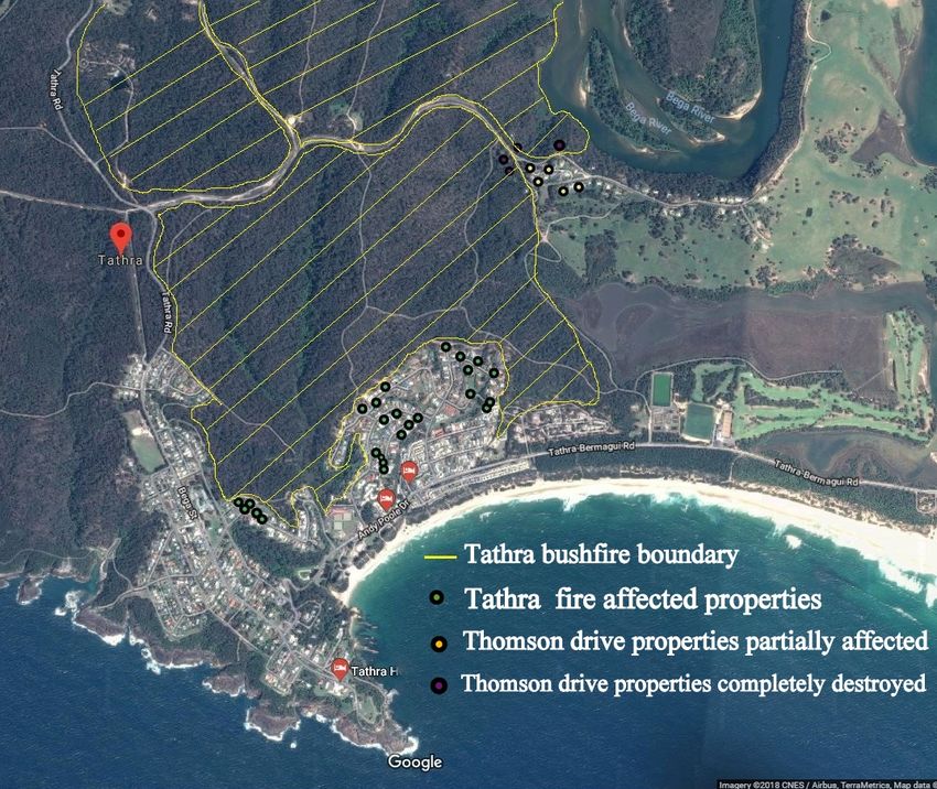
Figure 2: Fire seasons in Australian forests, source: Bureau of Meteorology.

Weather that mostly drives bushfires in Australia, works different across different regions of
Australia. In hot and dry summer, Southern Australia is vulnerable to bushfires while in dry
season northern Australia becomes more susceptible. Analysing meteorological conditions and
geographic information, we find that FSC lies in one of the most fire prone areas and probability
of wildfire is high in Summer, especially from December to March (Figure 2) (Fernandes 2001,
Castro et. al 2003, Andrews 1986).
Another key factor which determines forest fires is Fuel moisture content (FMC). FMC is the
amount of water per dry mass in forest fuel. FMC is a critical parameter in determining ignition,
intensity and rate of spread. Remote sensing data (MODIS satellite data) is mostly used to
determine FMC. Australian Flammability Monitoring System (AFMS) helps to visualize national
scale data on flammability, FMC and soil moisture 3.

Figure 3: Live forest moisture content (AFMS 2018)

3 http://wenfo.org/afms/#_/lvmc_mean/gfe_fire_weather/-36.79/149.78/11/20/4/2018/-36.722,149.963

7
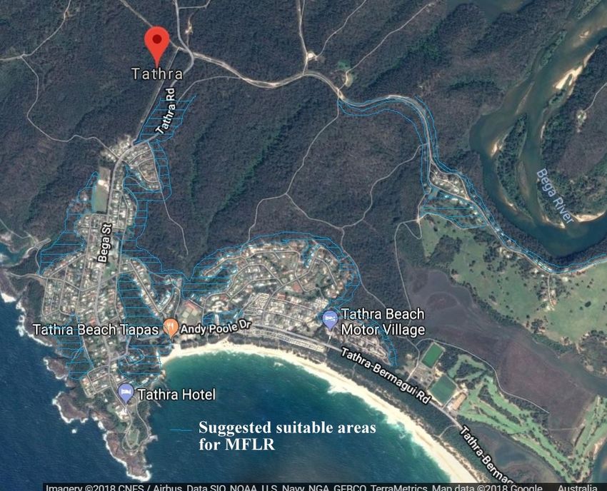
Figure 3 shows that FMC in FSC started decreasing from late Feb 2018 till March 2018 which
may be due to evaporation of water moisture from forest fuel. Schoenberg et al. (2003) found that
fire chances and burnt areas increase drastically when FMC decreases to around 90%.
It is very difficult to predict wildfire behaviour. Richard (1983) suggests that it can be predicted
if we have the following inputs:
    1. Geographical location of the area (slope, distance between vertical fuel groups);
    2. Forest fuel quality & quantity, its bulk density and moisture;
    3. Relative humidity and wind measurements (speed and direction).
Several fire simulators, including Phoenix Rapid-fire (developed by BNHCRC) and Spark
(developed by CSIRO) are routinely used to model and predict bushfire behavior in Australia.
These fire simulators integrate complex fire mechanism between fire and fuel distribution to
provide planning, response and evacuation applications.
To prevent bushfire various techniques are used, usually striving to reduce the amount of fuel
available in forest. Fuel reduction treatment modifies the forest fuel structure, load, distribution
and moisture content to such a level that if a bushfire occurs it will spread slowly and is easy to
control. Prescribed burning is one of the widely implemented fuel reduction technique in Australia
since 1950’s. Prescribed burning have a range of benefits including bushfire reduction,
biodiversity management, managing population of insects, some native plants need heat to
regenerate, recycle nutrients and low implementation cost.
Many fire prone areas which are highly biodiverse coexist with human developments. Prescribed
burning in these areas is difficult to implement as there is a risk of fire escape and strict limitations
on weather conditions have to be followed. Also prescribed burning has serious negative
consequences for human health and may cause wildlife habitat destruction. It produces dust and
smoke, impacts visibility and water quality. There is always a risk of fire escape. All this also
impacts social acceptance of prescribed burning, which needs further investigation. With current
changing climate, fire authorities have become more concerned about the effectiveness of existing
fuel reduction treatments. Other fuel reduction techniques should be explored considering the
ecological and social specifics of Australian ecosystems and communities.

Mechanical fuel load reduction
One such potential alternative is Mechanical fuel load reduction (MFLR) often known as
mechanical thinning. Mechanical thinning is considered a potential tool for reducing forest fires
(Volkova et al. 2017; Fernandes et al. 2018).
Mechanical thinning is an agricultural term that refers to removal of plants or portions of plants
by using various mechanical tools. One of the primary ecological objectives of thinning is to
decrease the canopy and improve tree growth and health (by improving tree spacing). Mechanical
thinning removes inferior trees to leave the resources to healthy (dominated) trees so that they
can grow more quickly (faster height and diameter). Thus, thinning allows removal of a tree which
is struggling to grow. There are two broad categories of thinning commercial and non-commercial
thinning. When applied to fire hazard reduction, MFLR assumes collecting a part of biomass,
primarily the dead organic material but not only, from the standing crop and the underlayer. As a
result the most easily combustible parts are to be collected, reducing the risk of fires, as well as
intensity if they still do occur.

8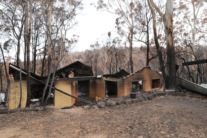
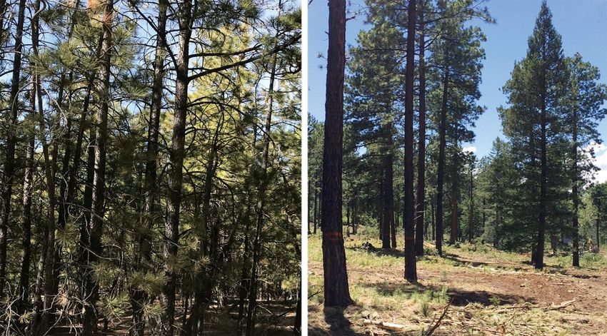
Figure 4: Before mechanical thinning and after mechanical thinning (L. Kapoor, 2017)

Volkova et al. (2017) studied the impacts of mechanical thinning in south east Australia and found
that thinning not only improves forest health, but also decreases the flammability of forests.
There are many possible benefits of implementing mechanical thinning which are:
    •   Low risk: Suitable for areas close to human developments.
    •   Addressing community concerns on prescribed burning.
    •   Environmentally friendly with no health concerns.
In addition to mechanical thinning, MFLR includes collection of the understory biomass using
various shredding, mowing and compacting devices.
MFLR can involve heavy mechanical machinery which is of significant cost. In USA, only 40%
of the cost of implementing mechanical thinning is offset by selling biomass (Grindlay 2015).
Some concerns of MFLR are soil damage, high implementation cost, effect on forest and wildlife,
water quality, biomass supply chain issues and facility geographical location. There is also a
debate on when and how much biomass should be extracted. According to (Fried and Barbour,
2009) biomass processing facilities below 15 megawatts are not cost competitive.

Mechanical Thinning: a case study
Forest managers in USA have been so strongly concerned with social and environmental issues
that prescribed burning is relatively rare there, especially in western forests. Forest thinning is a
more attractive and common practice, as they can improve stand structure along with forest
management objectives and wildfire management goals. In some forests forest thinning not only
helps in achieving firefighting goals, but also helps in ground water storage. Trees use a lot of
water for photosynthesis. They suck ground water and evaporate it as vapour in a process known
as evapotranspiration. This water becomes again accessible when it falls back to Earth as rain, so
overall this is an important process to maintain water balance over large territories. However
locally it may be huge loss. From 1990 to 2008, forest thinning saved 3.7 billion gallons of water

9
annually in California's Kings River Basin and 17 billion gallons in American river basin (nsf.gov, 2018). In California approximately two third of the water comes from Sierra Nevada forest which includes drinking water for 23 million population. Although, mechanical thinning is implemented on a large scale in California. Still, mechanical thinning is a dividing issue in California’s forest management and politics. President Trump’s tweet (on 5 Aug 2018) shows that his administration wants to expand the logging and timber industry in western California (Sahagun, 2018). Some environmental organizations (also involving opposition political parties) are opposing this idea of logging forest at such massive scale and are filing a lawsuit against the government. US government officials (Department of Interior) referred to them as “Environmental Terrorist groups” who are not letting authorities to implement forest management policy on 80 million acres of forest to stop wild fires (Starr 2018). On the other side environmental groups claim that assuming that a logged area is at no risk of forest fire is not true. The brush and saplings that grow in cleared forests have higher probability to ignite and burn much easier than bigger trees. Environmentalists also claim that small branches and leaves which remain on the surface increase fire probability. Besides this, implementation of heavy machinery destroys the soil, causes erosion and damages plants and environment. Figure 5: Heavy machinery may be involved in implementation of heavy thinning (Cart 2018) In 2018, California faced the worst summer fire in a decade and claims from this fire event were for more than $845 million (Insurance Journal, 2018). According to Kasler (2018) the volume of hectares that were consumed by wild fire by the end of this century will be 77% more than at present. In order to address this challenge California State is proposing a new legislation, which will help landowners to cut larger trees and build temporary roads in the forest for logging purposes. Forest agencies in California also offer a $10 permit to help people cut Christmas trees in overly dense stands. There are specific guidelines in the permit for cutting, which actually helps in thinning the forest to prevent wildfires. Without these permits, the forest would have to be 10
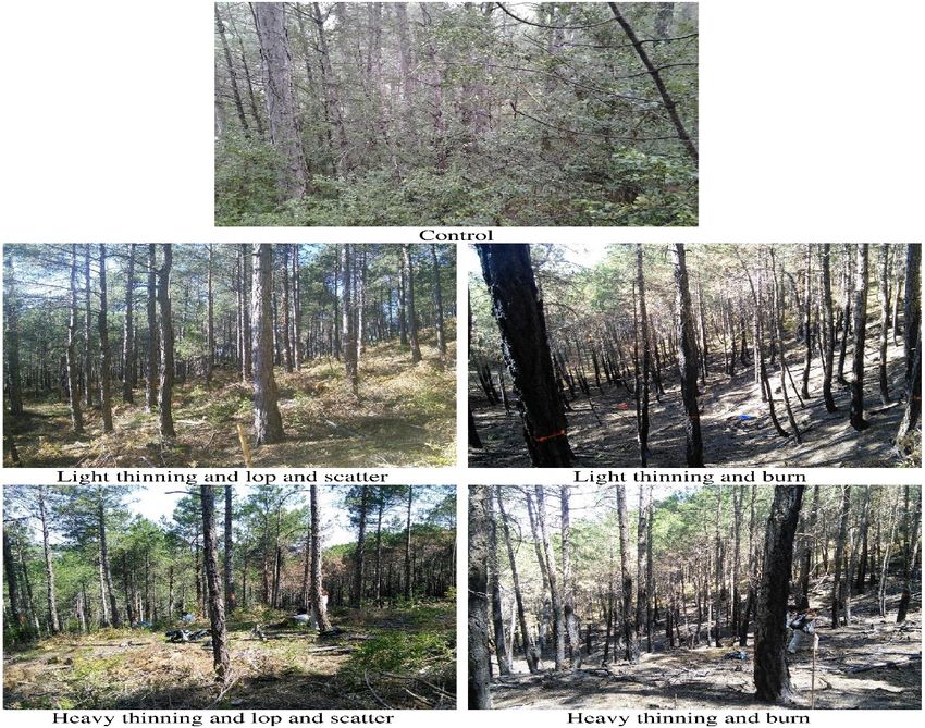
thinned by forest agencies (Brunell, 2017). California government is also initiating $1 billion
grant for fire department, cities and non-profit organizations to implement forest thinning in
coming five years (Rogers 2018).
Light thinning implies cutting the dead branches and clearing surface fuel (final canopy ≥ 75%)
while heavy thinning assumes removal of dead branches and trees (final canopy ≥ 50%). In heavy
thinning trees that are logged mostly include under growth trees so that rest of the trees can grow
healthier.

Figure 6: Different scenarios of thinning (Piqué and Domènech, 2018)

Mechanical thinning removes crowding around tree crowns which decreases branch mortality and
increases elongation, provides better photosynthetic process, helps tree diameter growth and
enhances environment. Thinning followed by lop and scatter increase the surface fuel and thus
probability of wild fires remains. Thinning followed by prescribed burning decreases the forest
fuel. Piqué and Domènech (2018) found that if burning is conducted after thinning then it makes
no difference for the risk of fire whether it is light or heavy.

11
RESEARCH METHODS
During this trip, we focused on two things:
       •     mapping the fire affected region of Tathra using GIS technology and
       •     exploring potential sites for MFLR implementation.
For mapping, we used an Android app “Village GIS”4 to collect the geographical location of each
property destroyed by bushfires. Village GIS is an open source app which allows users to
collected exact location information, geographical features like roads or slopes supporting both
raster and vector layers. Vector data are stored either in point, line or polygon formats. All
recorded points were further analyzed in QGIS 5. QGIS is an open source software which supports
multiple plugins to analyze spatial information. We used it to analyze our information and publish
it on Google maps.
We have also used this opportunity to interview residents and collect data to further explore the
social acceptance of MFLR.

4
    http://mspaceapps.in/~nagesh/VillageGIS/index.html
5
    https://qgis.org/en/site/

12
FINDINGS
Mapping Tathra Fires using GIS Technology.
The fire which was caused by a malfunction in electrical infrastructure on Reedy Swamp Road in
FSC forests near the bank of Bega River on 18th March 20186, was so intense that it crossed the
river and moved sporadically towards Thomson drive properties. Some Thomson drive properties
which were right in the middle of the forest were completely destroyed. The fire spread down
from Thomson drive towards Tathra. The properties locations, fire pattern and its direction of
spread were reconstructed and mapped using GIS app.
Figure 7: Mapping Tathra bushfires using QGIS
Thomson Drive Properties
Fire first affected the cluster of properties in Thomson drive. More than 60% of the properties of
Thomson drive were affected directly or indirectly. The data points were recorded on 28th March
2018. The red line in Figure 8 shows the Thomson drive area.
6
https://www.rfs.nsw.gov.au/news-and-media/media-releases/tathra-fire-investigation
13Figure 8: Bushfire affected properties of Thomson drive (data recorded 28 March, 2018) Tathra Properties Fire moved further down from Thomson drive towards Tathra residential area. The embers flew with immense heat and smoke, they attacked random locations in Tathra, which caused damage to some of the properties. Handmer (2005) found that most Australian houses are burnt due to ember attacks. Houses which have highly flammable external roof materials are more vulnerable to them. Small fires start and eventually lead to large fires if residents or fire services are not able to extinguish them, which burn whole houses or cause major damage to properties. Figure 9: Tathra properties affected by bushfires. The majority of destroyed Tathra houses were affected by ember attack, and most of them were not even close to forest. Residents described it as “a hail of fire, embers coming” (Gleeson, 2018). 14
Figure 9 shows that most of the fire affected houses are right in the middle of the town. Damage
from ember attack depends on a number of factors which include quality and quantity of the
embers, structure of the property, vegetation type around the property, surface fuel around the
property, prevailing weather conditions (i.e. wind speed and direction), suppression activities
during and after ember attack (Leonard & Bowditch 2003).

Mapping Tathra region for MFLR.
MFLR along with other techniques can be used as a fuel reduction technique, but with no smoke
and less impacts on environment. Also it can be done closer to communities in areas and
vegetation where prescribed burning is not possible. Cost of MFLR can be offset by using the
biomass collected for timber or energy generation. It is very efficient for small-moderate sized
areas, close to settlements, relatively flat-undulating terrain and no seasonal limits. Collection of
forest fuel (dead fuel and surface fuel) can decrease the intensity, size and probability of wildfire
(Regos et al. 2016).
Areas close to roads (transportation access) and areas that are populated (where implementing
HRB is especially risky) should be preferred for MFLR, while areas with difficult access and
remote areas are easier to treat with HRB. Areas, which we identified as more suitable for MFLR
are marked with blue in Fig.6. The assessment was made based on location information, access
difficulties and slope. These areas were selected after onsite analysis, using expert opinion and
GIS data analysis.
The area close to Thomson drive properties is easily accessible from the road, thus we suggest to
implement MFLR from Tathra road down to Thomson drive properties. The area provides quick
and easy access for harvest machinery. Further life cycle analysis needs to be performed before
implementation of MFLR.

Figure 10: Suggested areas for MFLR in Tathra

15
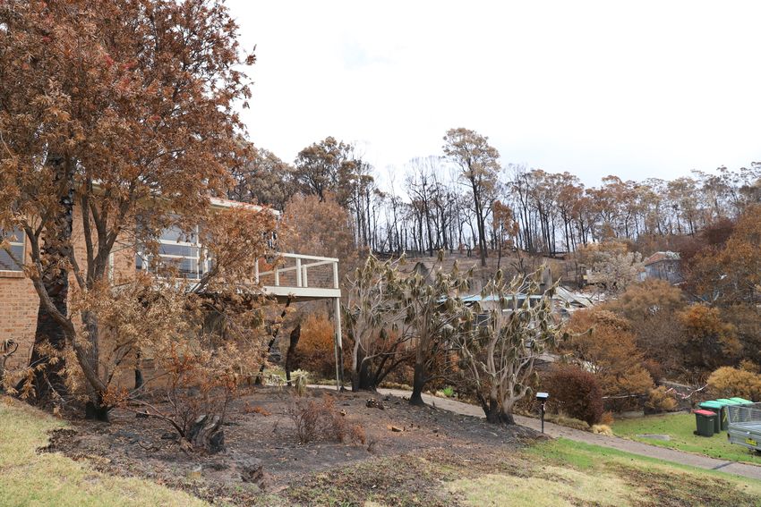
Risk of bushfire endangers many Australian communities and developments. Property loss is
greater in peri-urban developments, and quantifying bushfire risk is important for developing
rational planning regulations and fuel reduction policies. Developments in bushfire areas mostly
require the implementation of a safe distance from the vegetation. This is mostly known as asset
protection zone (APZ) or fire protection zone. The asset protection zone is further classified into
inner protection zone (IPZ) and outer protection zone (OPZ). The methodology is defined in
Planning for bush fire protection 20067. The IPZ should be located immediately next to an asset.
In Figure 11, we can see that the IPZ and OPZ were not implemented in these two properties in
Tathra. Burning IPZ (around 100m) every 1-4 years can save assets from bushfire except in the
event of extreme weather conditions (Bradstock et al., 1998).
Figure 11: High vegetation fuel around properties affected by bushfire in Tathra.
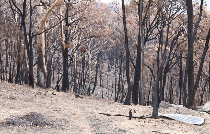
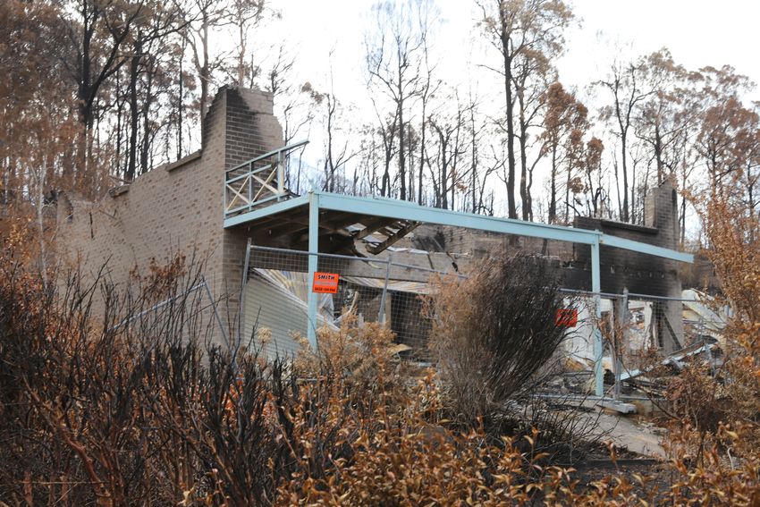
In our visit, we also found that some properties were right in the middle of the forest (see figure
12). These properties were surrounded by high forest fuel load along with slope. The slope angle
also contribute as a major factor in rapid fire spread to these properties. Fire tends to increases as
slope increases. This is because bushfire can easily reach unburnt fuel sources and can pre heat
them. Increase in slope also increases the speed and intensity of bush fire. With every 10 degree
increase in slope the bushfire rate of spread doubles (Country Fire Authority, 2018). Fire tends to
move slowly when slope decreases. As slope increases from Bega river towards Thomson drive
properties and Tathra, fire started to move much quicker with the support of wind as well.
7
https://www.rfs.nsw.gov.au/__data/assets/pdf_file/0008/4400/Complete-Planning-for-Bush-Fire-Protection-2006.pdf
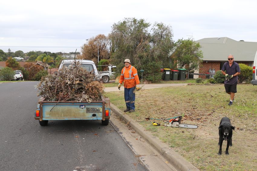
16Figure 12: Properties in the middle of forest with high fuel load. In our trip we explored the possible sites suitable for mechanical thinning. One of such possible sites is Thomson drive, which is easily accessible from road and has high loads of forest fuel (see figure 13). The extracted biomass can be easily transported to nearest facility for bioenergy production on a small scale or may be useful for local residents as a fuel source. Figure 13: Possible sites for implementing MFLR. According to (Parker, 2016) clearing of bush (waste biomass or live/dead fuel) around properties in fire prone areas is the most effective solution of bush fire mitigation. He also proposed a way out of implementing community funded biomass clearance and collection process and the valorisation of this biomass. We found that some of the local residents collect waste biomass (dead fuel) from surrounding of their assets and may later utilize this biomass as a fossil fuel alternative. 17
Figure 14: Tathra residents collecting biomass around their properties.

18
DISCUSSION
Bushfire is a natural complex landscape process which is driven by forest fuel load, heterogeneity
in vegetation, weather conditions, moisture content, timing and frequency of previous fuel
reduction treatments (Collins t al., 2010; Barbour et al., 2007). Bushfires are an important aspect
of many Australian ecosystems and indigenous culture from an estimated 60 million years
(Matsypura et al. 2018). Bushfire are the most occurring natural disaster in Australia. According
to (Ashe et al. 2009) bush fire causes almost 100 deaths and 3000 injuries every year. Over the
last 30 years, more than nine million Australians have been directly or indirectly impacted by
natural disaster mostly from bushfire (IAG 2017).
Before implementing mechanical thinning, life cycle assessment is needed to be explore the whole
process and assess its profitability with current practices. When comparing to existing practices
we should account for the costs of firefighting, asset protection, impacts on human health,
payments for carbon emissions and ecological impacts. Monetary estimates of some of these
factors can be quite difficult.
While implementing MFLR, there are a number of factors which need to be considered such as
access difficulties, suitable mechanical harvest system, costs, and social acceptability. Access
difficulties include slope of the area (slope must be less than 20 degrees), obstacles to operate
machinery, rocks and uneven land, type of soil, e.g. wet or soft soil, and transportation
accessibility of biomass from MFLR facility (Ximenes et al. 2017). However, little is known
about the effectiveness of implementing MFLR (alone) in Australian forests. Most likely a hybrid
system can be developed that will include a combination of both MFLR and HRB. We suggest
that bush fire characteristics (surface fuel load, crown height and density) must be included in
silvicultural treatment guidelines along with bushfire management goals and ecological
challenges. This would help in determining the most suitable treatment for each fuel type and
forest structure.
Our scoping survey has found that people living in bushfire prone areas have a positive attitude
(63%) towards prescribed fires. When asked about the MFLR, we found that the majority (58%)
of the respondents have no knowledge about MFLR techniques. People who reported prior
knowledge of MFLR, indicate that it has limited application due to geographical access,
ecological impacts and cost. Limited location application is the main issue reported by majority
of respondents (with prior MFLR knowledge). People also reported that there will be loss of
natural habitat for native wildlife that are supported by the presence of biomass
Yet it appears that there is good acceptance of MFLR among those respondents who have prior
knowledge about MFLR. The fact that local residents have different opinions about different fuel
reduction treatments is not surprising. Some of these groups may know about MFLR, while other
have no prior knowledge. People who support prescribed burning argue that it saves from
bushfires. People who do not support MFLR argue that they have no knowledge about its
effectiveness and applications. So, we can say that what influences people acceptance most is
their knowledge about the effectiveness of MFLR as a fuel reduction treatment in fire prone areas.
Analysing Facebook posts and Tweets bears the promise of further enriching our understanding
of social acceptance of various hazard reduction technologies.

19
CONCLUSION AND FUTURE RECOMMENDATIONS

We are thankful for the opportunity and funding provided by BNHCRC. This report results will
be used by the UTS research team, and may be also useful for the BNHCRC, land managers,
Rural Fire Services (RFS) and bushfire experts in Australia and around the world.
Even the best risk management can only reduce the bushfire risk, it cannot eliminate it completely.
Fire and land managers face serious challenges in developing strategies for effective fuel
management in extreme fire prone areas like Tathra. We need to act now to save our livelihoods,
environment, and resources from losses associated with wildfires. In this work we have to be open
for various alternative technologies and their combinations
During the short trip to the Tathra area we have seen many areas where MFLR could have been
applied. If cleared, some areas could certainly decrease the intensity of fire and the risks of
property damage. It is yet to be estimated what amounts of biomass can be harvested there and
how much of cost reduction this biomass could bring.
Further research is also needed to understand the perceptions and preferences of local residents,
and to explore whether social media can play a role in educating the public to address short and
long term (pre or post) disaster management goals.
Collective research over many years demonstrated that regardless of the fuel reduction strategies
and ecosystem conditions, communities can survive by taking several steps: clearing vegetation
near houses, protecting exterior of the house by inflammable materials, improving
communication ways for warning and participating in bushfire awareness community programs.
This research also demonstrates that social technologies are transformative in exposing public
concerns and issues.

20
REFERENCES
     1    Ashe, B., McAneney, K. and Pitman, A. (2009). Total cost of fire in Australia. Journal of Risk Research, 12(2), pp.121-
          136.
     2    Andrews, PL 1986, “BEHAVE: fire behavior prediction and fuel modeling system-BURN Subsystem, part 1.”
     3    Barbour, RJ, Singleton, R & Maguire, DA 2007, “Evaluating forest product potential as part of planning ecological
          restoration treatments on forested landscapes,” Landscape and Urban planning, vol. 80, no. 3, pp. 237–248
     4    Bengwayan, D. (2018). Thinning forests resulting in fuelwood shortage. [online] BusinessMirror. Available at:
          https://businessmirror.com.ph/thinning-forests-resulting-in-fuelwood-shortage/ [Accessed 8 Sep. 2018].
     5    Bradstock, R., Gill, A., Kenny, B. and Scott, J. (1998). Bushfire risk at the urban interface estimated from historical
          weather records: consequences for the use of prescribed fire in the Sydney region of south-eastern Australia. Journal of
          Environmental Management, 52(3), pp.259-271.
     6    Bradstock, RA 2010, “A biogeographic model of fire regimes in Australia: current and future implications,” Global
          Ecology and Biogeography, vol. 19, no. 2, pp. 145–158.
     7    Brunell, N. (2017). Why (and how) to cut down your own Christmas tree. [online] Kcra.com. Available at:
          https://www.kcra.com/article/why-and-how-to-cut-down-your-own-christmas-tree/14412492 [Accessed 8 Sep. 2018].
     8    Cart, J. (2018). Forest thinning isn’t as simple as it sounds. [online] Chico Enterprise-Record. Available at:
          https://www.chicoer.com/2018/08/30/forest-thinning-isnt-as-simple-as-it-sounds/ [Accessed 8 Sep. 2018].
     9    Castro, F, Tudela, A & Sebastià, M 2003, “Modeling moisture content in shrubs to predict fire risk in Catalonia (Spain),”
          Agricultural and Forest Meteorology, vol. 116, no. 1-2, pp. 49–59.
     10   Country Fire Authority. (2018). How Fire Behaves - Country Fire Authority. [online] Available at:
          https://www.cfa.vic.gov.au/plan-prepare/how-fire-behaves [Accessed 16 Aug. 2018].
     11   Collins BM, Stephens SL, Moghaddas JJ, & Battles J, 2010," Challenges and approaches in planning fuel treatments
          across fire-excluded forested landscapes", Journal of Forestry, vol. 108, no. 1, pp.24–31.
     12   Dutta, R, Das, A & Aryal, J 2016, “Big data integration shows Australian bush-fire frequency is increasing
          significantly,” Royal Society Open Science, vol. 3, no. 2, p. 150241.
     13   Fried, J. and Barbour, J. (2009). [online] Fs.fed.us. Available at: https://www.fs.fed.us/pnw/sciencef/scifi117.pdf
          [Accessed 5 Sep. 2018].
     14   Fernandes, PAM 2001, “Fire spread prediction in shrub fuels in Portugal,” Forest Ecology and Management, vol. 144,
          no. 1-3, pp. 67–74.
     15   Grindlay, D 2015, “Mechanical removal of trees to reduce bushfire risk; could America's $400 million program work in
          Australia?,” ABC News, accessed May 29, 2018, from ]
     16   Handmer, J & Tibbits, A 2005, “Is staying at home the safest option during bushfires? Historical evidence for an
          Australian approach,” Environmental Hazards, vol. 6, no. 2, pp. 81–91.
     17   Iag.com.au. (2017). Natural disaster costs to reach $39 billion per year by 2050 | IAG Limited. [online] Available at:
          https://www.iag.com.au/natural-disaster-costs-reach-39-billion-year-2050 [Accessed 9 Sep. 2018].
     18   Insurance Journal. (2018). Claims from California Summer Fires Top $845M, Commissioner Blames Climate Change.
          [online] Available at: https://www.insurancejournal.com/news/west/2018/09/06/500371.htm [Accessed 8 Sep. 2018].
     19   Janowitz, A & Biagi, L “Social Media & User-Generated Content,” Statista, accessed June 3, 2018, from

     20   KASLER, D. (2018). California wildfires will grow 77 percent as climate warms. Should forests be thinned? [online]
          sacbee. Available at: https://www.sacbee.com/news/local/environment/article217284390.html [Accessed 8 Sep. 2018].
     21   Kelly, B & Ronan, KR 2018, “Preparedness for natural hazards: testing an expanded education- and engagement-
          enhanced social cognitive model,” Natural Hazards, vol. 91, no. 1, pp. 19–35.
     22   L. Kapoor, M. (2017). Ancestral Pueblo practices could save New Mexico pinelands. [online] The Journal. Available at:
          https://the-journal.com/articles/77948 [Accessed 9 Sep. 2018].
     23   Leonard J, Bowditch P, 2003. Findings of studies of houses damaged by bushfire in Australia. Third International
          Wildland Fire Conference, NSW.

21
24 Matsypura, D., Prokopyev, O. A., & Zahar, A. (2018). Wildfire fuel management: Network-based models and
optimization of prescribed burning. European Journal of Operational Research, 264(2), 774–796.
https://doi.org/10.1016/j.ejor.2017.06.050
25 Nsf.gov. (2018). Billions of gallons of water saved by thinning forests | NSF - National Science Foundation.[online]
Available at:https://www.nsf.gov/news/news_summ.jsp?cntn_id=245128&WT.mc_id=USNSF_51&WT.mc_ev=click
[Accessed 8 Sep. 2018].
26 Parker, A. (2016). Selective clearing of bush close to houses is the top bushfire mitigation strategy. Australian Planner,
53(2), pp.152-155.
27 PENMAN, T., BINNS, D., SHIELS, R., ALLEN, R. and KAVANAGH, R. (2008). Changes in understorey plant species
richness following logging and prescribed burning in shrubby dry sclerophyll forests of south-eastern Australia. Austral
Ecology, 33(2), pp.197-210.
28 Piqué, M. and Domènech, R. (2018). Effectiveness of mechanical thinning and prescribed burning on fire behavior in
Pinus nigra forests in NE Spain. Science of The Total Environment, 618, pp.1539-1546.
29 Pohl, D, Bouchachia, A & Hellwagner, H 2018, “Batch-based active learning: Application to social media data for crisis
management,” Expert Systems with Applications, vol. 93, pp. 232–244.
30 Power, R & Kibell, J 2017, “The Social Media Intelligence Analyst for Emergency Management,” Proceedings of the
50th Hawaii International Conference on System Sciences (2017).
31 Fernandes, P. M. (2018). Scientific support to prescribed underburning in southern Europe: What do we know? Science
of The Total Environment, 630, 340–348. https://doi.org/10.1016/j.scitotenv.2018.02.214
32 Russell-Smith, Jeremy, Cameron P. Yates, Peter J. Whitehead, Richard Smith, Ron Craig, Grant E. Allan, Richard
Thackway, Ian Frakes, Shane Cridland, Mick C. P. Meyer, and A. Malcolm Gill. "Bushfires down Under: Patterns and
Implications of Contemporary Australian Landscape Burning." International Journal of Wildland Fire 16, no. 4 (2007):
361. doi:10.1071/wf07018.
33 Regos, A, Aquilué, N, López, I, Codina, M, Retana, J & Brotons, L 2016, “Synergies Between Forest Biomass
Extraction for Bioenergy and Fire Suppression in Mediterranean Ecosystems: Insights from a Storyline-and-Simulation
Approach,” Ecosystems, vol. 19, no. 5, pp. 786–802.
34 Rogers, P. (2018). California’s $1 billion plan to reduce wildfire risk. [online] Chico Enterprise-Record. Available at:
https://www.chicoer.com/2018/08/31/1-billion-plan-to-reduce-california-wildfire-risk/ [Accessed 8 Sep. 2018].
35 Rogers, P. (2018). California’s $1 billion plan to reduce wildfire risk. [online] Chico Enterprise-Record. Available at:
https://www.chicoer.com/2018/08/31/1-billion-plan-to-reduce-california-wildfire-risk/ [Accessed 8 Sep. 2018].
36 Rfs.nsw.gov.au. (2018). [online] Available at: https://www.rfs.nsw.gov.au/__data/assets/pdf_file/0020/4691/Hunter-
BFRMP.pdf [Accessed 1 Sep. 2018].
37 Rothermel, R. (1983). [online] Fs.fed.us. Available at: https://www.fs.fed.us/rm/pubs_int/int_gtr143.pdf [Accessed 9
Sep. 2018].
38 Russell-Smith, J, Yates, CP, Whitehead, PJ, Smith, R, Craig, R, Allan, GE, Thackway, R, Frakes, I, Cridland, S, Meyer,
MCP & Gill, AM 2007, “Bushfires down under: patterns and implications of contemporary Australian landscape
burning,” International Journal of Wildland Fire, vol. 16, no. 4, p. 361.
39 Sahagun, L. (2018). Los Angeles Times - We are currently unavailable in your region. [online] Latimes.com. Available
at: http://www.latimes.com/local/california/la-me-california-fires-blog-as-trump-tweets-about-california-fires-
1533693230-htmlstory.html# [Accessed 8 Sep. 2018].
40 Starr, P. (2018). Exclusive: Interior Sec. Zinke: Environmental Zealots Stoke Fires. [online] Breitbart. Available at:
https://www.breitbart.com/big-government/2018/08/13/exclusive-zinke-environmental-terrorist-groups-western-us-
wildfires/ [Accessed 8 Sep. 2018].
41 Sachdeva, S, Mccaffrey, S & Locke, D 2016, “Social media approaches to modeling wildfire smoke dispersion:
spatiotemporal and social scientific investigations,” Information, Communication & Society, vol. 20, no. 8, pp. 1146–
1161.
42 Tibbits, A & Whittaker, J 2007, “Stay and defend or leave early: Policy problems and experiences during the 2003
Victorian bushfires,” Environmental Hazards, vol. 7, no. 4, pp. 283–290.
43 UTS Survey link: https://docs.google.com/forms/d/1h1CjHEDFhaKlfpe311-pIG1dLLJdchvdL3omDZ4O3TI/edit
2244 Volkova, L., Bi, H., Hilton, J. and Weston, C. (2017). Impact of mechanical thinning on forest carbon, fuel hazard and
simulated fire behaviour in Eucalyptus delegatensis forest of south-eastern Australia. Forest Ecology and Management,
405, pp.92-100.
45 Wood, DW 2017, “The Effect of Higher Temperatures on Wildfire Size: Evidence from Wildfires on U.S. Forest Service
Lands in the Northern Rockies,” SSRN Electronic Journal.
46 Ximenes, F, Stephens, M, Brown, M, Law, B, Mylek, M, Schirmer, J, Sullivan, A & Mcguffog, T 2017, “Mechanical
fuel load reduction in Australia: a potential tool for bushfire mitigation,” Australian Forestry, pp. 1–11.
47 Yates, CP, Edwards, AC & Russell-Smith, J 2008, “Big fires and their ecological impacts in Australian savannas: size
and frequency matters,” International Journal of Wildland Fire, vol. 17, no. 6, p. 768.
48 “Australia's bushfire seasons” How do rainbows form? - Social Media Blog - Bureau of Meteorology, accessed May 29,
2018, from http://media.bom.gov.au/social/blog/50/australias-bushfire-seasons/
23You can also read