North East Fire Management Area Fire Protection Plan 2018
←
→
Page content transcription
If your browser does not render page correctly, please read the page content below
North East Fire Management Area
                           Fire Protection Plan
                                       2018

North East Fire Protection Plan 2017              1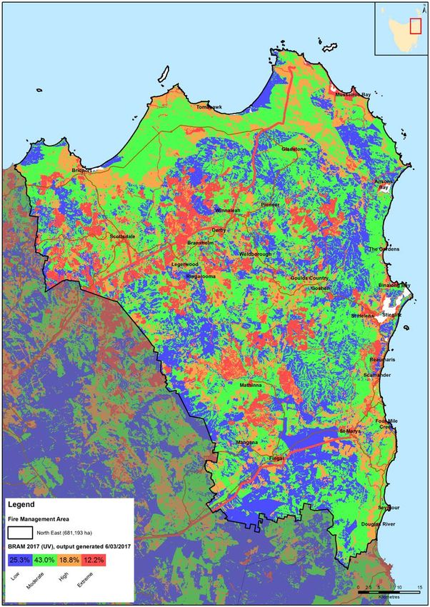
Document Control
Document History
Version                     Date               Author           Section
1.0                         2014               Steve Summers    Draft
2.0                         2014               Steve Summers    Final
3.0                         15 November 2015   Chris Moore      Draft
4.0                         30 November 2015   Chris Moore      Final
5.0                         7 December 2016    Chris Moore      Draft
6.0                         21 December 2016   Chris Moore      Final
7.0                         August 2017        L. Dean          Draft

Document Endorsements
Agency            Name & Title                 Signature       Date
Bob Knox          STT
Peter Burr        Tas Networks
Chris Emms        PWS
Steve Lowe        TFS
Donna Stanley     PWS
Rodney Moore      TFS
Louise Mcconachie TasWater
Tim Samoilov      Tas Networks
Chris Simms       Hydro Tasmania
Dwaine Griffin    Dorset Council
Chris Hughes      Break O’Day
                  Council

Document Endorsed by North East Fire Management Area Committee

Acting FMAC Chair - Steven Lowe

Accepted by State Fire Management Council

SFMC Chair – Ian Sauer
Date: 30 April 2018

North East Fire Protection Plan 2018                                      2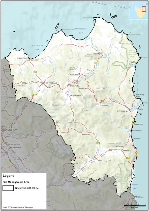
Table of Contents

Document Control ............................................................................................................ 2
   Document History ......................................................................................................... 2
   Document Endorsements ............................................................................................. 2
   Document Endorsed by North East Fire Management Area Committee....................... 2
Table of Contents ............................................................................................................ 3
Glossary .......................................................................................................................... 5
Acronyms......................................................................................................................... 8
Chapter 1          Introduction ............................................................................................... 10
   1.1      Background ...................................................................................................... 10
   1.2      Aim and Objectives .......................................................................................... 10
   1.3      The Project Plan .............................................................................................. 10
   1.4      Policy, Standards and Legislation .................................................................... 10
      Standards ............................................................................................................... 11
      Legislation............................................................................................................... 11
Chapter 2          Establishing the Context ............................................................................ 12
   2.1      Description of the North East Fire Protection Plan Area ................................... 12
      2.1.1 Location, Boundaries and Land Tenure ......................................................... 12
      2.1.2 Climate and Bushfire Season ......................................................................... 14
      2.1.3 Vegetation ...................................................................................................... 14
      2.1.4 Population and Demographics ....................................................................... 15
      2.1.5 Bushfire Frequency and Causes of Ignition.................................................... 16
Chapter 3          Analysing and Evaluating Bushfire Risk .................................................... 17
   3.1      Analysing Bushfire Risk ................................................................................... 17
   3.2      Likelihood ......................................................................................................... 17
   3.3      Consequence (values at risk) ........................................................................... 17
   3.4      Overall Risk...................................................................................................... 18
   3.5      Risk Analysis for the North East Fire Management Area.................................. 19
      3.5.1        Community Assessment ............................................................................ 19
Chapter 4          Bushfire Risk Treatment ............................................................................ 22
   4.1 Planning framework .............................................................................................. 22
      4.1.1 Community risk management ........................................................................ 22
      4.1.2 Bushfire-Ready Neighbourhoods Program – Tasmania Fire Service ............. 23
   4.2      Region wide Controls ....................................................................................... 23
      4.2.1        Strategic fire infrastructure ........................................................................ 24
      4.2.1.1          Strategic fire trails ................................................................................. 24

North East Fire Protection Plan 2018                                                                                               3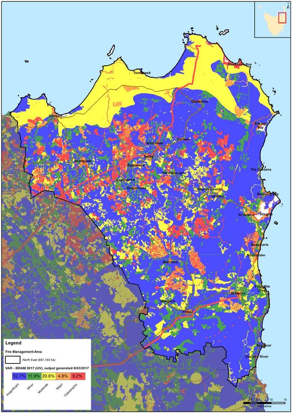
4.2.1.2          Fire breaks ............................................................................................ 25
      4.2.1.3          Strategic roads ...................................................................................... 26
      4.2.1.4 Detection Towers ........................................................................................ 26
      4.2.2        Strategic Burning Program ........................................................................ 27
   4.3      Asset Specific Treatment Strategies ................................................................ 27
   4.4      Treatment Selection and Priorities ................................................................... 28
   4.5      Implementation Program .................................................................................. 29
   4.6      Implementation ................................................................................................ 29
Chapter 5          Monitoring and Review .............................................................................. 30
   5.1      Review ............................................................................................................. 30
   5.2      Monitoring ........................................................................................................ 30
   5.3      Reporting ......................................................................................................... 30
References .................................................................................................................... 31
   Appendices ................................................................................................................ 32
   Appendix 1 – Maps of FMAC area displaying context information .............................. 32
   Appendix 2 - The Bush Fire Risk Model (BRAM)........................................................ 39
      Background............................................................................................................. 39
      The process ............................................................................................................ 39
      Ignition potential ...................................................................................................... 40
      Suppression capabilities ......................................................................................... 41
      Fire Behaviour Potential .......................................................................................... 42
      Values at risk .......................................................................................................... 43
      Limitation of the process ......................................................................................... 44
   Appendix 3 – NERAG risk assessment approach ...................................................... 45
      Consequence table ................................................................................................. 46
      Impact Category Definitions .................................................................................... 47
      Likelihood table ....................................................................................................... 47
      Qualitative risk matrix.............................................................................................. 47
   Appendix 4 – Bushfire Risk Assessment Maps .......................................................... 48
   Appendix 5 – TFS Community Fire Safety Division Programs.................................... 52
   Appendix 6 – Implementation program ....................................................................... 54
   Appendix 7 - Strategic fuel management program ..................................................... 67
   Appendix 8 – Description of vegetation communities ................................................. 69

North East Fire Protection Plan 2018                                                                                             4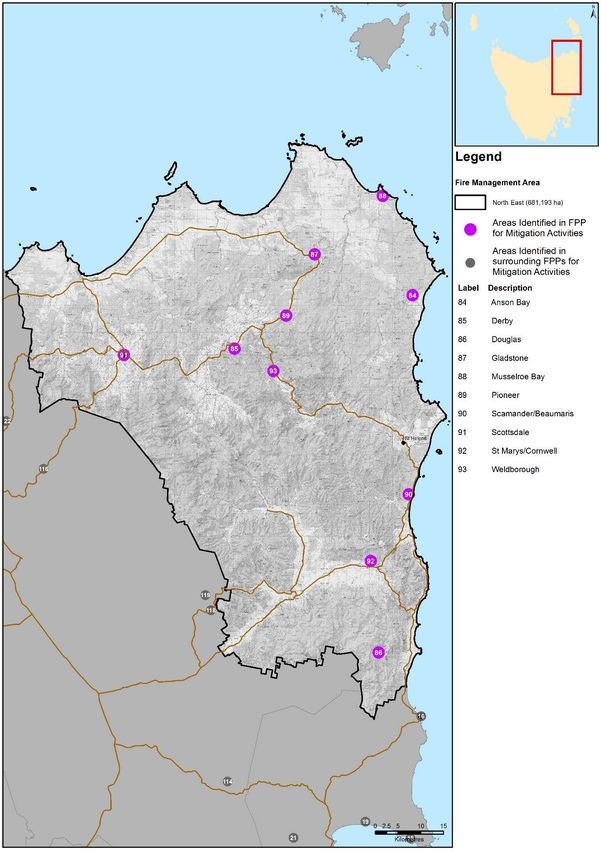
Glossary

Asset                     A term used to describe anything valued by the community that
                          may be adversely impacted by bushfire. This may include
                          residential  houses,     infrastructure, agriculture, industry,
                          environmental and heritage sites.

Asset Zone                The geographic location of asset(s) of high value or importance and
                          the physical boundary immediately around the asset.

Asset Protection          An area of high strategic importance to protect values in the asset
Zone                      zone. Regular fuel reduction should be undertaken in the vicinity of
                          specific assets (up to 1km wide around the asset). The area within
                          1.05km of a human settlement area (SFMC Fuel Strategy).

Strategic Fuel            Area of management that will increase the likelihood of controlling a
Management                bushfire within or the forward spread through the area. Located
Zone                      strategically in fuel types of high or greater flammability. Fuel to be
                          managed by prescribed burning. Between 1.05km and 6.05km from
                          a human settlement area (SFMC Fuel Strategy)

                          An area that is managed to meet the objectives of the relevant land
Land
                          manager, which can be planned fire for fuel reduction, biodiversity
Management
                          conservation or forest regeneration.
Zone
                          Bushfire Risk Assessment Model – A computer based modelling
BRAM
                          tool that uses a series of inputs to assess the risk of bushfire to a
                          specific area. The BRAM has a capacity to produce a series of
                          outputs. It was developed and is managed by Tasmanian Parks &
                          Wildlife Service (State Fire Protection Plan)

Bushfire                  Unplanned vegetation fire. A generic term which includes grass
                          fires, forest fires and scrub fires both with and without a
                          suppression objective.

Bushfire Hazard           The potential or expected behaviour of a bushfire burning under a
                          particular set of conditions, i.e. the type, arrangement and quantity
                          of fuel, the fuel moisture content, wind speed, topography, relative
                          humidity, temperature and atmospheric stability.

Bushfire Risk             A systematic process to coordinate, direct and control activities
Management                relating to bushfire risk; with the aim of limiting the adverse effects
                          of bushfire on the community.

Community                 A bushfire plan for community members that provides local,
Bushfire                  community-specific information to assist with bushfire preparation
Protection Plan           and survival. The focus of the Bushfire Protection Plan is on
                          bushfire safety options, and the intent of the plan is to support the
                          development of personal Bushfire Survival Plans.

Community                 An Emergency Management Plan for emergency managers and
Bushfire                  responders. The Bushfire Response Plan aims to better protect
North East Fire Protection Plan 2018                                                           5
Response Plan             communities and their assets during bushfire emergencies, through
                          the identification of protection priorities and critical operational
                          information. These plans make firefighting resources safer and
                          more effective.

Community                 A strategic plan that focuses on addressing bushfire hazards, and
Mitigation plan           improving the survivability of communities and assets. The Bushfire
                          Mitigation Plan identifies key areas for fuel management, and
                          provides tactical guidance regarding prescribed burning, fuel
                          treatment, fire management infrastructure, and asset protection
                          work.

Consequence               Consequences are defined as a qualitative rating of damage from
                          fire to values.

Fire Management           Classification system for the area to be managed. The zoning
Zoning                    system indicates the primary fire management purposes for an
                          area of land.

Human                     Term given for the dataset used to define where people live and
Settlement Area           work. The dataset was developed for the purpose of risk modelling
                          and was created using a combination of building locations,
                          cadastral information and ABS data. Includes seasonally populated
                          areas and industrial areas.

Likelihood                Likelihood is defined as a qualitative method to assess the
                          likelihood rating to the consequences occurring.

Risk                      The effect of uncertainty on objectives. (Note: risk is often
                          expressed in terms of a combination of the consequences of an
                          event and the associated likelihood of occurrence.)

Risk Acceptance           The informed decision to accept a risk, based on the knowledge
                          gained during the risk assessment process.

Risk Analysis             The application of consequence and likelihood to an event in order
                          to determine the level of risk.

Risk Assessment           The systematic process of identifying, analysing and evaluating
                          risk.

Risk Criteria             Standards (or statements) by which the results of risk assessments
                          can be assessed. They relate quantitative risk estimates to
                          qualitative value judgements about the significance of the risks.
                          They are inexact and should be seen as guidelines rather than
                          rules.

Risk Evaluation           The process of comparing the outcomes of risk analysis to the risk
                          criteria in order to determine whether a risk is acceptable or
                          tolerable.

North East Fire Protection Plan 2018                                                         6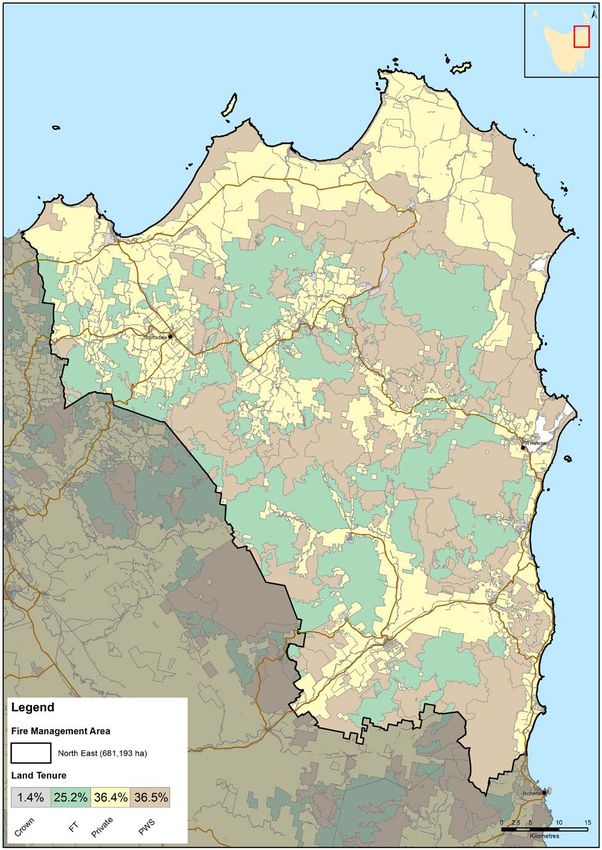
Risk                      The process of recognising, identifying and describing risks.
Identification

Risk Treatment            A process to select and implement appropriate measures
                          undertaken to modify risk.

North East Fire Protection Plan 2018                                                      7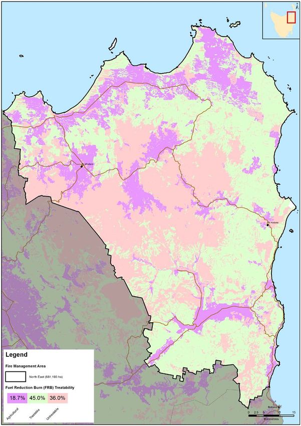
Acronyms

BPP                    Bushfire Planning & Policy

BRAM                   Bushfire Risk Assessment Model

BRN                    Bushfire Ready Neighbourhood

COAG                   Council of Australian Governments

CPP                    Community Protection Planning

DPIPWE                 Department Primary Industry, Water & Environment

FIAT                   Forest Industry Association Tasmania

FMAC                   Fire Management Area Committee

FPA                    Forest Practices Authority

FPP                    Fire Protection Plan

FRU                    Fuel Reduction Unit

STT                    Sustainable Timber Tasmania

HSA                    Human Settlement Area

NEFMA                  North East Fire Management Area

NERAG                  National Emergency Risk Assessment Guidelines

PWS                    Parks and Wildlife Service

REMC                   Regional Emergency Management Council

SEMC                   State Emergency Management Committee

SFMC                   State Fire Management Council

SFPP                   State Fire Protection Plan

SVFMP                  State Vegetation Fire Management Plan

TFGA                   Tasmania Farmers and Graziers Association

TALC                   Tasmanian Aboriginal Land Council

TFS                    Tasmania Fire Service

North East Fire Protection Plan 2018                                      8
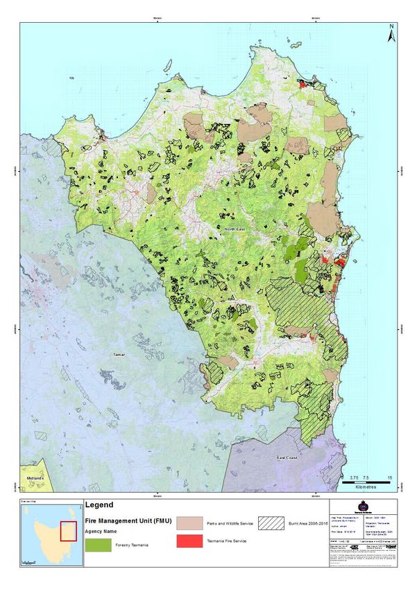
Maps contained in this document may include data provided by DPIPWE (Information
and Land Services Division (ILS), and Parks and Wildlife Service (PWS) Fire
Management Section), and Tasmania Fire Service (TFS). These map products have
been produced by the Tasmania Fire Service. While all efforts have been taken to
ensure the accuracy of these products, there may be errors and/or omissions in the data
presented. Users of these products are advised to independently verify data for
accuracy and completeness prior to use.

North East Fire Protection Plan 2018                                                 9
Chapter 1 Introduction
1.1   Background
Under Section 20 of the Fire Service Act 1979, Fire Management Area Committees
(FMAC’s) are required to submit to State Fire Management Council (SFMC), on an
annual basis, a Fire Protection Plan (FPP) for its fire management area commencing on
1 October. The submission date was changed to the 31st of December for 2016 and
beyond.
It is a requirement of the FPP that it is consistent with the State Fire Protection Plan
(SFPP) and the State Vegetation Fire Management Policy (SVFMP).

1.2     Aim and Objectives
The aim of this FPP is to document a coordinated and efficient approach towards the
identification and treatment of bushfire-related risk within the North East Fire
Management Area (NEFMA).
The objective of this FPP is to effectively manage bushfire related risk within the
NEFMA in order to protect people, assets and other things valuable to the community.
Specifically, the objectives of this plan are to:
    •   Guide and coordinate a tenure blind bushfire risk management program over a
        five (5) year period
    •   Document the process used to identify, analyse and evaluate risk, determine
        priorities and develop a plan to systematically treat risk
    •   Facilitate the effective use of the financial and physical resources available for
        bushfire risk management activities
    •   Integrate bushfire risk management into the business processes of Local
        Government, land managers and other agencies
    •   Ensure integration between stakeholders
    •   Clearly and concisely communicate risk in a format that is meaningful to
        stakeholders and the community; and
    •   Monitor and review the implementation of the Plan, to ensure enhancements are
        made on an on-going basis

1.3    The Project Plan
A Project Plan has been developed to outline the responsibilities and timing for key
milestones in the development of the FPP and is attached at Appendix 1. The Project
Plan has been mutually agreed to by the relevant stakeholders and endorsed by the
Committee of the NEFMA.

1.4    Policy, Standards and Legislation
The following policy, standards and legislation were considered to be applicable to the
development and implementation of the FPP:

        •   Tasmanian Emergency Management Plan
        •   State Fire Protection Plan
        •   State Vegetation Fire Management Policy
North East Fire Protection Plan 2018                                                    10
Standards
• AS/NZS ISO 31000:2009 - Risk Management – Principles and Guidelines
• AS 3959 – 2009 - Construction of buildings in Bushfire prone areas
• Forest Practices Code 2015
• Tasmanian Electricity Code
Legislation
• Aboriginal Relics Act 1975 (soon to be replaced)
• Fire Service Act 1979
• Emergency Management Act 2006
• National Parks and Reserve Management Act 2002
• Nature Conservation Act 2002
• Crown Lands Act 1976
• Forestry Act 1920
• Tasmanian Forests Agreement Act 2013
• Forest Practices Act 1985 and Forest Practices Code 2015
• Threatened Species Protection Act 1995
• Environmental Protection & Biodiversity Act 1999
• Environmental Management and Pollution Control Act 1994
• Local Government Act 1993
• Weed Management Act 1999
North East Fire Protection Plan 2018 11Chapter 2 Establishing the Context
2.1 Description of the North East Fire Protection Plan Area
2.1.1 Location, Boundaries and Land Tenure
The North East can be considered a distinct region within Tasmania.
The NEFMA covers two local government areas, namely Dorset and Break
O’Day. The plan area encompasses an area enclosed by the north coast, from
the mouth of the Pipers Brook heading in south easterly direction to just below
the mouth of the Douglas River. The area of the FMA is approximately 681193
ha.
The principal industries present within the fire management area tourism, mining,
forestry, agricultural and aqua culture. The area has a variety of land tenure
classes present including:
Tenure type Total area (ha) Percentage
Private Freehold 239,950 35.39
Permanent Timber Production Zone Land 171,845 25.35
Future Potential Production Forest (Crown) 110,317 16.27
Regional Reserve 73,197 10.80
National Park 34,391 5.07
Conservation Area 20,149 2.97
State Reserve 7,847 1.16
Conservation Covenant 7,172 1.06
Casement 4,244 0.63
Crown Land 3,412 0.50
Nature Recreation Area 1,614 0.24
Public Reserve 1,376 0.20
Private Sanctuary 845 0.12
Inland Water 723 0.11
Local Government 508 0.07
Authority Crown 174 0.03
Nature Reserve 75 0.01
Tas Water 35 0.01
Private Nature Reserve 25 0.00
Authority Freehold 15 0.00
Historic Site 13 0.00
Local Government Act Reserve 11 0.00
LGA Conservation Area 10 0.00
Commonwealth 1 0.00
Hydro-Electric Corporation 0 0.00
Table 1: Tenure Area
North East Fire Protection Plan 2018 12Map 1: FMA boundary location North East Fire Protection Plan 2018 13
Land Manager/Agency                      % of Land Managed within the FMA
  Forestry Tasmania                                               25.2
  DPIPWE                                                          37.9
  Local Government                                                 2.4
  Commonwealth
The classification of ecological vegetation communities is often an artificial process as
vegetation exists as a complex continuum (Kitchener and Harris, 2013).

The vegetation can also be categorised into 12 broad groups that represent broad
vegetation or landscape types. A description of the vegetation groups can be found in
Appendix 8.

A breakdown of the principle vegetation groups present and the flammability within the
NEFMA as per TasVeg 3.0 classification is:

                 Vegetation Group                Flammability       Percentage of area
                                                    (Pyrke and
                                                 Marsden-Smedley,
                                                      2005)
  Agricultural, urban and exotic vegetation     Moderate                  32.10
  Dry eucalypt forest and woodland              Moderate -                38.10
                                                high
  Highland and treeless vegetation              High                       0.04
  Moorland, sedgeland, rush lands and peat      Moderate -                 0.98
  lands                                         high
  Native grassland                              High                       0.55
  Non eucalypt forest and woodland              Moderate                   2.75
  Other natural environments                    Moderate                   1.64
  Rainforest and related scrub                  Low                        4.65
  Saltmarsh and wetland                         Low                        0.29
  Scrub, heathland and coastal complexes        High – Very                5.85
                                                high
  Wet eucalypt forest and woodland              Moderate                  13.05
Table 3: Vegetation Groups

The vegetation can also be considered in terms of its “treatability” with regards to fuel
reduction programs. Treatable fuels suitable for planned burns are typically dry eucalypt
forest, scrub complexes, heath complexes and button grass. Agricultural lands while
susceptible to the impact of bush fires are not consider treatable due to the nature of the
land use. However this does not preclude agricultural land from being incorporated into
burning operations.

2.1.4 Population and Demographics
There is a diverse range of communities present with 55 human settlement areas (HSA)
currently identified within the NEFMA. Settlement areas are associated with the eastern
and northern coastal strips together with the Fingal Valley, Ringarooma River and the
agricultural lands near Scottsdale Approximately 63% of the HSA are found inland.
Major community centres include Scottsdale, St Helens, Fingal, St Marys, Bridport and
Scamander.

Currently the population present within the NEFMA is approximately 13,500, though this
number increases markedly during the summer period through influx of tourists and
absentee landowners. Break O’Day local government area currently has a population
around 6,500 while the Dorset local government area has a similar number.

North East Fire Protection Plan 2018                                                     15
2.1.5 Bushfire Frequency and Causes of Ignition
The north east has a long history of bush fires with a corresponding impact on adjacent
communities. The 2006 Lohery’s Road fire impacted on the communities at Scamander,
Four Mile Creek, and St Marys with 40 structures lost. In addition, there was
considerable impact on the local tourism industry suffered from the perception that the
East coast was closed as a consequence of the fire.
While bush fires occur across the whole region, there exists distinct spatial clustering of
fires within FMA. The first cluster being the East coast, the second is the area
associated with MT Cameron, Banca Road and Old Port Road and the third being
Scottsdale and surrounds. Major fires that have impacted on the North East Region
include:
Fire name Ignition date Size(ha)
Killymoon - Valley 2/11/1981 641.84
Road
St Helens Point SRA 3/12/1993 481.4
Watersmeeting 7/12/1994 12339.21
Humbug SRA 27/9/1995 509.47
White Rock Tier 22/2/1996 1648.9
Peacock Creek 22/3/1998 763.57
Barlows Creek 4/3/1999 567.37
Little Boobyalla River 14/2/2000 2717.05
Mt William/Cameron 4/4/2001 829.32
Mt Stronach 26/10/2003 1037.87
Eddystone Point 15/11/2003 3234.78
Tebrakunna 15/11/2003 2155.7
Oxberry Road 15/11/2003 1090.66
Rayners Rd 11/10/2004 922.47
Doctors Peak 13/10/2004 6328.22
Homestead Road 22/1/2005 1595.34
Mount Cameron 4/3/2006 4392.44
Lohrey’s Road 10/12/2006 30899.49
Weise Road 27/1/2007 554.67
Erickson’s Road 13/1/2008 1115.88
Bellingham Road 16/1/2008 2594.42
Garibaldi 15/11/2008 759.03
Rossarden Road 22/1/2009 2349.32
Valley Road Fingal 6/2/2013 2036.68
Banca Road 27/04/2016 2256
Table 4: Major fires
North East Fire Protection Plan 2018 16There is a paucity of fire records for the planning area where ignition sources have been
identified. Analyses of the records that exist indicate that the principle causes of ignition
are:
Ignition source % of ignitions
Undetermined 0.6
Unknown 1.1
Planned burn re-ignitionThe consequences were taken directly from the output generated through the Values at
Risk spatial layer output (Appendix 2 – maps 8 to 11). Region wide values utilised in the
BRAM modelling include:
Constructed values
• Wildland urban interface
• Critical infrastructure including transmission lines, telecommunication
infrastructure and transport links
• Burnable infrastructure
• Heritage buildings
• Non burnable
• Neighbouring houses ( life)
• Parks and Wildlife Asset base including life
Forest / agricultural
• Production Forest both state owned and private
• Horticulture production
• Research monitoring sites
Natural values
• Flora and Fauna( fire sensitive and threatened species)
• Water catchments
• Geo-morphic values
3.4 Overall Risk
A representation of risk is developed when you combine the factors of likelihood and
consequence. The generated output map of risk shows qualitative areas of risk, not
areas of perceived risk.
The model assists in objectively defining areas where genuine risk is present. In-depth
analysis will indicate what factor is driving the risk for a given area.
BRAM Bushfire Risk Assessment results for North East Fire Management Area:
BRAM level of Area (ha) % of FMA
Risk
Low 222750 25.3%
Moderate 249316 43.0%
High 131470 18.8%
Extreme 73568 12.2%
North East Fire Protection Plan 2018 183.5 Risk Analysis for the North East Fire Management Area
The bush fire risk Model BRAM was utilised to examine risk across the fire management
area. For a simplified explanation of the BRAM model and associated NERAG process
refer to Appendix’s 3 and 4.
In addition Phoenix Rapidfire, a bush fire simulator, developed by the University of
Melbourne (Kevin Tolhurst and Derek Chong) was used to model the risk of fires
impacting on communities present in the NEFMA. This modelling was done as part of
the state wide strategic fuel management assessment. The process involved modelling
potential ignition points, incorporating worst case scenario weather patterns and
examining fire behaviour based on current fuel loads to identify the potential impact on
human settlement areas.
An understanding of where potential ignition point that may impact on communities is
crucial. It must be understood that such analysis has many limitations but does
provided an indication a where communities may be under risk as well as identify areas
where strategic burning will assist in changing fire behaviour.
Output maps identifying risk, likelihood of ignition and potential ignition points are
outlined in Appendix 4.
3.5.1 Community Assessment
Strategic assessment tools have been used to conduct a broad scale assessment
across the NEFMA to identify communities vulnerable to bushfire, that require more
detailed assessment using more locally specific processes. Selection and prioritisation
of treatments was done using a combination of:
• BRAM and Phoenix computer modelling results
• Expert opinion of fire practitioners
• Local knowledge from TFS District Officers and Brigades
• Identification and consideration of existing and past fire management actions and
plans
• Consultation with TFS Community Protection Planners
The results of the strategic assessment for the NEFMA are outlined below in Table 6.
Community Assessment Rating Priority
Scamander – Beaumaris High High
St Marys- Cornwall High High
Anson Bay High High
Derby Mod Mod
Pioneer High High
Gladstone Mod Mod
Weldborough Mod Mod
Scottsdale Mod Mod
Musselroe Bay Mod Mod
Table 6: Results of the Strategic Assessment
North East Fire Protection Plan 2018 19While an initial categorisation of priority is highlighted, all human settlement areas have effectively the same priority. The priority for implementation of these risk management strategies for the designated human settlement area will be subject to availability and resources required to develop plans and implement the programs. A number of communities already have specific plans in place, these are summarised in Appendix 5. North East Fire Protection Plan 2018 20
Map 2 – Areas Identified in FPPs for Mitigation Activities

North East Fire Protection Plan 2018                         21
Chapter 4 Bushfire Risk Treatment
4.1 Planning framework
Fire management zoning is a classification system for the area to be managed. Zoning
provides a framework by identifying where fire preparedness works and planned burning
should occur.

Ellis etal, 2004 recommended that all jurisdictions in should adopt a zoning strategy to
assist with mitigation planning particularly fuel management areas. The process should
be applied at a landscape level but the concept can be applied to localised community
protection. Ellis etal, 2004 also highlights that the rural–urban interface and the
agriculture – conservation reserve interface are the areas where bushfire poses the
greatest risks to lives, property and economic values. The most effective way of
managing these areas is by identifying ‘fire management zones’ across the landscape
and having clear objectives for each zone.

Clear objectives for each zone should be outlined and stakeholders and the community
should be involved. The fire management zones to be used in developing fire strategies/
mitigation plans within the Furneaux fire protection area are:

    •   Asset: This is a feature that is either man made or natural of significant value in
        which a fire will have negative impact.
    •   Asset Protection Zone: This is typically the rural–urban interface, where regular
        fuel reduction should be undertaken in the vicinity of specific assets. This zone
        provides the highest level of localised protection to human life property and highly
        valued assets. Mitigation works may include mechanical fuel modification, fuel
        reduction burning, evacuation, and engineering and community awareness and
        preparation programs.
    •   Strategic Fuel Management Unit: This aims to provide areas of reduced fuel in
        strategic areas, to reduce the speed and intensity of bushfires and reduce the
        potential for spot-fire development.
    •   Land Management Zone: The primary purpose here is to meet the objectives of
        the relevant land manager, which can be planned fire for fuel reduction,
        biodiversity conservation or forest regeneration.

4.1.1 Community risk management
In developing mitigation plans for local communities, the strategic methodology by Ellis
etal, 2004 outlined above is to be to be used as the basis of the mitigation planning
process. Mitigation plan provides a means of articulation and managing risk for HSA’s.

The strategies to be used in developing fire mitigation plans include:

    •   zoning as per COAG recommendations 2004 ( Ellis etal, 2004)
    •   fire and management regimes - fuel reduction burning including criteria / triggers
        for repeated burning
    •   other fuel treatments such as slashing
    •   fuel breaks
    •   fire ready neighbour development programs
North East Fire Protection Plan 2018                                                     22
In addition, 2 other planning processes need to be developed and incorporated into the
works programs to manage the risk present with the fire management area;
• Community bushfire protection planning (TFS) - Community Bushfire Protection
Plans are prepared for community members that provide local information to
assist with bushfire preparation, and survival
• Community bushfire response planning (TFS) - Community Bushfire Response
Plans are prepared for emergency managers to better protect communities and
their assets during bushfire emergencies
4.1.2 Bushfire-Ready Neighbourhoods Program – Tasmania Fire Service
A Community Development Coordinator and regionally based Community
Development Officers (Hobart, Launceston and Burnie) have identified 22
communities/areas state-wide which are being targeted by the Bushfire-Ready
Neighbourhoods Program as part of round 2 (2016 to 2018) of the program. The
program takes a community development (‘grass roots’) approach and recognises
that there isn’t a one size fits all approach to bushfire preparedness, highlighting that
‘we all play a part’ (individuals, TFS, communities). Specifically the program takes a
community led approach providing local community members in higher bushfire risk
areas community engagement activities for preparing for and preventing bushfire/s.
The program is facilitated by accessing existing community networks and resources
and developing localised strategies in bushfire preparedness. Some of the planned
community engagement activities include; community forums, information sessions
for communities and brigades alike, workshops, property assessments, field days,
focussed group activities and establishment of Bushfire-ready neighbourhood
groups.
For more information about the Bushfire-Ready Neighbourhoods Program visit:
www.fire.tas.gov.au/brn
Round 1 (2014-2016) and Round 2 (2016-2018) communities for the North East are
listed in 4.4 Treatment Selection and Priorities and Appendix 6 in this document.
4.2 Region wide Controls
The following controls are currently in place across the Furneaux fire management area
to assist in the strategic management of bushfire related risk:
• Legislative controls – including abatements, fire restrictions etc
• Public education campaigns and the use of TFS Community Fire Safety
Programs and SFMC state-wide programs tailored to suit local needs; eg
Community Education – Bushfire Ready Neighbourhoods (BRN) Program,
Bushfire Planning and Policy (BPP) – Community Protection Planning (CPP) and
private land burning programs (see Appendix 5 for further details)
• State-wide arson prevention programs developed in conjunction with TAS Police
and TFS
• Setting of appropriate land subdivision and building standards in line with State
Bushfire Prone Area Building Standards
North East Fire Protection Plan 2018 23• Performance monitoring and reporting of FPP outcomes to the relevant
Emergency Management Council and State Fire Management Council (SFMC)
as required by the Tasmanian Emergency Management Plan and the Fire
Service Act 1979
4.2.1 Strategic fire infrastructure
Strategic fire infrastructure includes critical fire access tracks and water sources.
Critical fire infrastructure identified for the NEFMA.
4.2.1.1 Strategic fire trails
To be of strategic value, fire trails should be located in the following situations:
• Adjacent to the assets which they are required to protect
• Lead to strategic water sources
• Break up large tracts of contiguous flammable vegetation
• to facilitate access and egress to assets
• To provided boundaries for prescribed burning blocks
Strategic fire trails identified for the North East FPP are:
Strategic Trail Start (UTM) Finish (UTM) Minimum
Standard
required
Mt William NP
West Boundary 597011.625 5471357.5 602601.3125 5467156.5 Class 5
North South 602605.75 5462661 602602.5625 5462705 Class3
(main) Fire trail
Baileys Hill 602602.5625 5462705 610141.4375 5464067.5 Class 5
Rock creek 602589.5 5467761 607755.5625 5468496 Class 5
Track
Little Boggy 591860.9375 5456015.5 594833.4375 5460939.5 Class 5
Big Boggy 597586.375 5455702.5 598691.0625 5459561.5 Class 5
Rattys track 589765.1875 5456742.5 597586.375 5455702.5 Class 3
Binalong Bay
Reid’s road to 606416.875 5433046.5 606403.375 5433063.5 Class 5
the gardens
Humbug Hill 609251.125 5430798 608926.5 5432124 Class 5
Mt Cameron
Regional
Reserve
Mt Cameron 578626.5625 5464923 578624.5625 5464923 Class 5
East
Mt Cameron 575216.375 5464302.5 568112.875 5463554 Class 5
West
Douglas
Apsley NP
Organ Hill track 595122.125 5376021.5 595108 5375973.5 Class 5
North East Fire Protection Plan 2018 24Pennyfather 598109.3125 5373281 593386.75 5371638.5 Class 5
track
Apsley east 603742.5625 5372456.5 602901.875 5368814 Class 5
Tim Mine gully 601988.125 5383169 596901.9375 5384837.5 Class 5
Track
Thompson 598463.4375 5386671.5 602586.875 5382889.5 Class 5
marshes
South Apsley 599114 5363977.5 598466.6875 5362403.5 Class 5
Apsley Link 594993.1875 5365401 594609.375 5371144 Class 5
West Apsley 594644.625 5376313 593910.75 5375843 Class 5
trail
Table 7: Fire Trails
Fire trails should be maintained to an appropriate standard. Currently the only
standards within Tasmania dealing with fire infrastructure are the PWS’s Fire
Management Infrastructures Categories and Standards V4 and the Forest
Practice Code 2015. These should be used as a guide in the maintenance of fire
infrastructure.
Not all access tracks will be considered critical fire infrastructure though they may
have use in fire operation. Such tracks may be maintained for a variety of
purposes including management and recreation activities. The decision to
maintain will be the prerogative of the land manager (including private
landowners) controlling access to such a track.
4.2.1.2 Fire breaks
Throughout the NEFMA, there currently exist a plethora of fire breaks. Fire
breaks are maintained by both Sustainable Timber Tasmania (STT) and PWS.
Breaks are maintained for the protection of both communities and individual
assets such as forestry coupes. Currently there is a variety of standards being
applied to the maintenance of fire breaks.
The identification of firebreaks is an ongoing issue the FMAC will need to
concentrate on. Many breaks have been created over the year by different
organisation. These fire need to be identified, examined as to the strategic value
and works programs, including implementation coordination, identified.
Appropriate standards need to be applied to the maintenance of these breaks.
North East Fire Protection Plan 2018 254.2.1.3 Strategic roads
In addition to the public road network present in the NEFMA, certain roads
managed by other authorities have value in emergency management. A strategic
road provides internal connectivity to the region and provides essential links in
areas where there are poor transport accessibility issues. Identified strategic
roads within the region are:
• MG Road
• S Road
• Kennel Road (formerly known as Fire Road)
• Valley Road
• Argonaut Road
• Mt Albert Road
• Mathina Plans Road
• Ben Ridge Road
• Diddleum Road
• Old Port Road
• Banca Road
• Old Waterhouse Road
• Tebrakuma Road
• Counsels Road
• Chaplin’s Road
4.2.1.4 Detection Towers
The fire protection area currently has several fire detection towers. The towers
are manned when the fire danger rating is 12 or above. In addition the towers
carry radio repeaters for the STT/ PWS radio network.
Towers within the Protection area are:
Tower Location( UTM) Height( M Management
Authority
Mt Horror 561592 543533 670 m Forestry Tasmania
Platts Lookout 590147 5437723 465 m Forestry Tasmania
South Sister 597812 5401283 840 m Forestry Tasmania
Tower Hill 571154 5400091 1117m Forestry Tasmania
Table 8: Detection Towers
North East Fire Protection Plan 2018 264.2.2 Strategic Burning Program
The fuel loads in the strategy area are such that any wildfire has the potential to
impact on a range of assets including residential properties. The objective of
managing this risk is to modify the fire behaviour of any wildfire so that there exists,
an improved window of opportunity to control or contain wildfire events. The basic
strategy is to develop a mosaic of fuel reduced areas within the strategy area over a
time frame of several years through the use of the most suitable methods. The
imposition of a burning regime that establishes a mosaic of burns can be used to
ensure wildfire impacts are minimised. It also ensures fire dependent species are
maintained. Appropriate techniques may include but are not restricted to such
processes as fuel reduction burning, slashing and fire break construction.
A strategic burning program to be commenced with the aim of reducing fuels across
the fire management area. To facilitate this, sections of the protection plan area has
been zoned as strategic fuel management and land management units. Strategic fuel
management units identified within the fire protection area are:
• Golconda • The Gardens
• Banca • Scamander
• Mt Cameron • Fingal Valley
• Mt William • Douglas
The fuel management units are highlighted on map 12 and are based on treatable
fuels and as such are indicative of the actual area to be considered. Within the fuel
management units present in the fire protection area, initial burn blocks have been
identified and are highlighted on map 13, Appendix 7.
Selection of the initial burn blocks is based on identification of treatable fuels,
previous fire history, the need to reinforce existing fire trails and the need to
implement a mosaic of fuel reduced areas across the landscape. The current
program incorporates existing burning programs from STT and PWS. Some burn
blocks will incorporate private freehold.
4.3 Asset Specific Treatment Strategies
There are five broad asset specific treatment strategies that have been used to manage
the bushfire risks identified in the Community Risk Assessment. They include:
• Fuel management – treatments include the reduction / modification of bushfire
fuels through manual, chemical and prescribed burning methods
• Ignition management - treatments aim to reduce the occurrence of human
induced ignitions in the landscape
• Preparedness – treatments focus on providing suitable access and water supply
arrangements that will assist with firefighting operations
• Planning – treatments relate to the development of plans that will improve the
ability of firefighters and the community to respond to bushfire; and
North East Fire Protection Plan 2018 27• Community Engagement – treatments seek to build relationships, raise
awareness and change behaviours relating to the management of bushfire
related risks within the community
4.4 Treatment Selection and Priorities
A strategic bushfire risk assessment has been undertaken for the entire NEFMA. This
strategic assessment was used to identify key communities and assets considered to be
at risk of bushfire and prioritise the preparation and implementation of different treatment
strategies.
In developing strategies for addressing the risk the fire management area was zoned to
identify areas that require works. This was in addition to the examination of the risk
outline above. Principally the FPA were zoned based on:
• Asset protection zones around HSA’s
• Asset protection zones around critical assets
General risk management approaches to the major human settlement areas present
within the fire management area are:
• Scamander/ Beaumaris/Dianas Basin: Community Bushfire Mitigation Plan
(developed), Community Protection Plan (developed), Community Response
Plan (developed) and Bushfire Ready Neighbourhood Program (completed)
• St Marys- Cornwall: Strategic Bushfire Mitigation Plan (developed). and
Bushfire Ready Neighbourhood Program (completed)
• Ansons Bay: Community Bushfire Mitigation Plan planned proposed for 2017/18.
• Derby: Community Protection Plan (developed), Community Response Plan
(developed) and Bushfire Ready Neighbourhood Program (completed)
• Pioneer: Development of a Strategic Bushfire Mitigation Plan
• Gladstone: Development of a Strategic Bushfire Mitigation Plan
• Weldborough: Implementation of a BRN Program
• Tonganah: Development of a Strategic Bushfire Mitigation Plan
• Golconda: Development of a Strategic Bushfire Mitigation Plan. Development of
a BRN Program
• Nabowla: Development of a Bushfire Ready Neighbourhood Program
• Musselroe Bay: Development of a Community Bushfire Mitigation Plan
• Tomahawk: Development of a Community Bushfire Mitigation Plan proposed for
2018/19
• Stieglitz: Bushfire Ready Neighbourhood (BRN) Program (completed)
North East Fire Protection Plan 2018 284.5 Implementation Program
Under the terms of reference for the North East Fire Management Area Committee
(FMAC), the committee has objectives to:
• Provide a point of coordination and cooperation for FMAC members
• Review plans and processes to ensure interoperability between stakeholders and
the broader community
The FMAC will coordinate the implementation strategy identified in appendix 6. The
committee will be involved in identifying organisation or agencies to complete the risk
management strategies required under the fire protection plan. Implementation of the
various risk management controls and strategies identified in the fire protection plan will
be the responsibility of the identified land manager/ agency.
The FMAC will liaise with the SFMC to develop a strategy to address funding for works
and risk management strategies to address community obligations.
4.6 Implementation
When the treatments identified in this FPP are implemented there are a number of
issues that need to be considered by the responsible agency including
1. Environmental impact and assessment
2. Aboriginal and European heritage
3. Prescribed burn plans and approvals
4. Smoke management associated with planned burning programs
5. Community consultation
6. Community partnerships
North East Fire Protection Plan 2018 29Chapter 5 Monitoring and Review
Monitoring and review processes are in place to ensure that the FPP remains current
and valid. These processes are detailed below to ensure outcomes are achieved in
accordance with the Implementation Schedule.
5.1 Review
This FPP, including appendices, will be subject to a comprehensive review every five (5)
years from the date of approval, unless significant circumstances exist to warrant earlier
review. The review process would include examination of:
• Changes to the FPP area, organisational responsibilities or legislation
• Changes to the bushfire risk in the area; or
• Following a major fire event
In addition, the FMAC should identify:
• Shortcomings in data
• Change of usage of the area
• New or changes to asset values within the fire protection area
Data shortcomings and changes to values (both community and natural) identified by the
review process are to be passed to the state fire council for inclusion in ongoing risk
modelling being carried out at the state level.
In addition, to complete the NERAG assessment process, the development of an asset
risk register detailing specific risk treatments should be developed. Information derived
from this process is to be incorporated into individual community mitigation plans as well
as the wider strategic FPP.
5.2 Monitoring
The implementation program at Appendix 6 is a living document and progression
towards completion of the treatments proposed will be monitored and reviewed at least
every six (6) months by the FMAC.
At a state wide level, the SFMC will be examining the impacts of the strategic burning
program on risk management as part of the strategic fuel management program.
The implementation program will be updated as treatments are progressed and
completed.
5.3 Reporting
A report detailing progress towards implementation of this FPP will be provided annually.
Reporting performance criteria should address;
• Planning outcomes including mitigation plans, community protection plans,
community response plans
• Implementation progress of community mitigation programs
• Completed strategic burns
• Development and maintenance of strategic fire infrastructure
North East Fire Protection Plan 2018 30References Ellis, S., Kanowski, P., & Whelan, R., 2004, National Inquiry on Bushfire Mitigation and Management, Commonwealth of Australia, Canberra; Fox-Hughes, P., 2008, A fire danger climatology for Tasmania, in Australian Meteorology Magazine, 57 p109 – 120, BOM, Melbourne; Kitchener, A., and Harris, S., 2013, From Forest to Fjaeldmark: Descriptions of Tasmanian Vegetation Edition 2, Department of Primary Industries, Parks, Water and Environment, Hobart; National Emergency Management Committee, (2010), National Emergency Risk Assessment Guidelines, Tasmanian State Emergency Service, Hobart; Parks and Wildlife Service (unpublished), Bushfire Risk Assessment Model Project Business Process Model (2008). Department of Primary Industries, Parks, Water and Environment, Hobart; Parks and Wildlife Service (unpublished). Tasmanian Bushfire Risk User Guide (2010). Department of Primary Industries, Parks, Water and Environment, Hobart; Parks and Wildlife Service (unpublished). Tasmanian Bushfire Risk Assessment Model (2013). Department of Primary Industries, Parks, Water and Environment, Hobart; Parks and Wildlife Service, 2009, Northern Region Strategic Fire Management Plan, Department of Primary Industries, Parks, Water and Environment, Hobart; Pyrke A.F., and Marsden-Smedley J.B., 2005, Fire-attributes categories, fire sensitivity and flammability of Tasmanian vegetation communities, Tasforests 16: 35-47, Forestry Tasmania, Hobart; State Fire Management Council, 2014, Bushfire in Tasmania: A New Approach to Reducing Our Statewide Relative Risk. Department of Police and Emergency Management, Hobart. North East Fire Protection Plan 2018 31
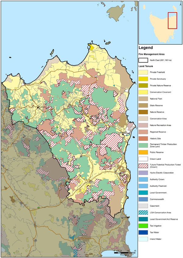
Appendices

Appendix 1 – Maps of FMAC area displaying context information

Map 1: Land Tenure

North East Fire Protection Plan 2017                            32
Map 2: Land Tenure (4 Classes)

North East Fire Protection Plan 2018   33
Map 3: Fuel Treatability

North East Fire Protection Plan 2018   34
Map 4: Population

North East Fire Protection Plan 2018   35
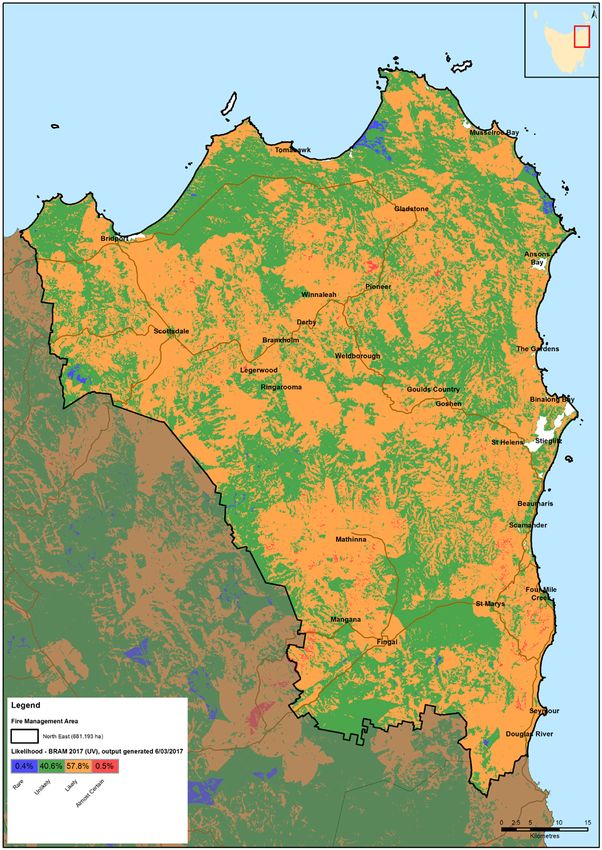
Map 5: Ignition Cause

North East Fire Protection Plan 2018   36
Map 6: Fire Frequency

North East Fire Protection Plan 2018   37
Map 7: Vegetation Groups

North East Fire Protection Plan 2018   38
Appendix 2 - The Bush Fire Risk Model (BRAM)

Background
The Bushfire Risk Assessment Model (BRAM) is a software product that was developed
by the Fire Management Section of PWS (DPIPWE). The aim of the model is identify
bush fire risk at a strategic level as well as to identify the elements driving actual bush
fire risk.
A stakeholder group was set up to oversee the process. Stakeholders involved in
developing the process included:
     •    Parks and Wildlife Service
     •    Tasmania Fire Service
     •    Forestry Tasmania
     •    Tasmanian Farmers and Graziers Association
     •    State Emergency Service
     •    Forest Industries Association of Tasmania
     •    Local Government Association of Tasmania
     •    Resource management and conservation, DPIPWE
     •    NRM
     •    Tasmanian Aboriginal Land and Sea Council
Additional working groups were set up to advise on specialist areas such as values at
risk, suppression capabilities, ignition potential, and fire behaviour.
The process is aligned to the Australian/New Zealand Standard AS/NZS 4360:2004
Australian Standard Risk Management and the updated standard AS/NZS ISO
31000:2009 Risk management – Principles and guidelines.              Risk is defined as the”
effect of uncertainty on objectives” with a focus of the effect on the objectives.

The process
The model is built in a geographic information system that utilizes various spatial
orientated data, fire behaviour and fuel accumulation models and climate records. The
data and values were developed by consensus of a range of stakeholders.
The process applies the same set of assessment rules to the data contained in the
model, thus it can be applied across the state. The process is tenure blind.
The BRAM identifies the likelihood and consequence of a fire at a particular point.
The risk is determined through the use of a qualitative risk matrix incorporating likely
hood and values at risk (consequences). The process identifies the actual risk at that
point not the perceived risk. The output is in the form of layers identifying the likelihood,
values at risk and actual risk.
The model uses 4 major areas to calculate risk:
     •    Fire behaviour potential - the manner in which fuel ignites, flame develops, and
          fire spreads and exhibits other related phenomena (likelihood)

North East Fire Protection Plan 2017                                                      39
• Ignition potential - the probability or chance of fire starting as determined by the
presence of causative agents (likelihood)
• Suppression capability - the factors and limitations that are related to the ability
to contain a bushfire upon detection (likelihood)
• Values at risk - a specific or collective set of natural resources and man-made
improvements and/or developments that have measurable or intrinsic worth,
and which could potentially be destroyed or otherwise altered by fire in any
given area (consequence)
Ignition potential
North East Fire Protection Plan 2018 40Suppression capabilities North East Fire Protection Plan 2018 41
Fire Behaviour Potential

North East Fire Protection Plan 2018   42
Values at risk

North East Fire Protection Plan 2018   43
Limitation of the process
   • BRAM does not incorporate the likelihood and consequence at the same point
       from a fire occurring in an adjacent area
    •   BRAM does not display the risks posed by an area adjacent to a particular point
    •   Mitigation works undertaken on adjacent areas do not change the risk at a
        particular point
    •   The process is based on available data, there are significant gaps in data e.g. fire
        history on private lands
    •   Untested assumptions – may over/underestimate risk

North East Fire Protection Plan 2018                                                      44
Appendix 3 – NERAG risk assessment approach
(Derived from the National Emergency Management Committee (2010), National Emergency Risk Assessment Guidelines,
Tasmanian State Emergency Service, Hobart)
The NERAG provide a methodology to assess risks from emergency events and are
principally concerned with risk assessment. The NERAG methodology was utilised in
development of the BRAM to develop the final risk profile.
The guidelines are not intended to address the entire risk management framework or the
risk management process as outlined in AS/NZS ISO 31000:2009. However, because
they focus on the assessment of risks from emergency events, they ultimately direct the
management of emergency risks in line with the international standards for risk
management.
The guidelines aim to provide a risk assessment methodology that:
• enables focus on risks in small (e.g. municipal) or large (e.g. regional and/or
state and/or national) areas
• is useable for both risk ‘from’ and risk ‘to’ (e.g. risk from bushfire, risk to
infrastructure from all or specific sources of risk)
• uses a scenario-based approach
• samples risk across a range of credible consequence levels
• identifies current risk under existing controls and residual risk assuming
implementation of additional controls or control improvements
• provides base-line qualitative risk assessments and triggers for more detailed
analysis
• allows risk evaluation at varying levels of confidence
• Provides outputs that are comparable, which rate risk and suggests means to
reduce risk
Risk analysis is the element in the process through which the level of risk and its nature
is determined and understood. Information from risk analysis is critical to rank the
seriousness of risks and to help decide whether risks need to be treated or not. In this
phase, control opportunities are also identified. The analysis involves consideration of
possible consequences, the likelihood that those consequences may occur (including
the factors that affect the consequences), and any existing control that tends to reduce
risks. During this phase the level of confidence in the analysis is assessed by
considering factors such as the divergence of opinion, level of expertise, uncertainty,
quality, quantity and relevance of data and information, and limitations on modelling. At
the conclusion of this step, all identified risks are categorised into risk levels and given a
risk rating, and statements concerning existing controls and their adequacy are made.
NERAG takes an all hazards approach and provides a method that is suitable for
considering other sources of risk beside fire.
North East Fire Protection Plan 2017 45You can also read