Strategic bushfire management plan - Alpine and North East - delwp
←
→
Page content transcription
If your browser does not render page correctly, please read the page content below
Strategic bushfire
management plan
Alpine and North East
Mildura

               Mallee and Murray
                   Goulburn

                                                                                          Wangaratta

                                                              Bendigo                              Alpine and
                    Horsham
                                                                                                   North East

                                                       West
                                                      Central
                                                                                                                     Alpine and Greater
                      South
                                                   Ballarat                                                              Gippsland
                     Western
                                                                        Melbourne    East                       Bairnsdale
                                                                                    Central
                                                          Geelong
                                                                                              Morwell
                                         Barwon
                                         Otway

© The State of Victoria Department of Environment, Land, Water and Planning 2015

This work is licensed under a Creative Commons Attribution 4.0 International licence. You are free to re-use the work under that licence,
on the condition that you credit the State of Victoria as author. The licence does not apply to any images, photographs or branding, including
the Victorian Coat of Arms, the Victorian Government logo and the Department of Environment, Land, Water and Planning (DELWP) logo.
To view a copy of this licence, visit http://creativecommons.org/licenses/by/4.0/
Printed by Impact Digital, Brunswick.
ISBN 978-1-74146-702-4 (print)
ISBN 978-1-74146-703-1 (pdf)

Disclaimer
This publication may be of assistance to you but the State of Victoria and its employees do not guarantee that the publication is without flaw
of any kind or is wholly appropriate for your particular purposes and therefore disclaims all liability for any error, loss or other consequence
which may arise from you relying on any information in this publication.

Accessibility
If you would like to receive this publication in an alternative format, please
telephone the DELWP Customer Service Centre on 136186, email
customer.service@delwp.vic.gov.au, or via the National Relay Service on 133 677
www.relayservice.com.au. This document is also available on the internet at
www.delwp.vic.gov.au.
Front cover image: Planned burning at Dartmouth Dam © DELWP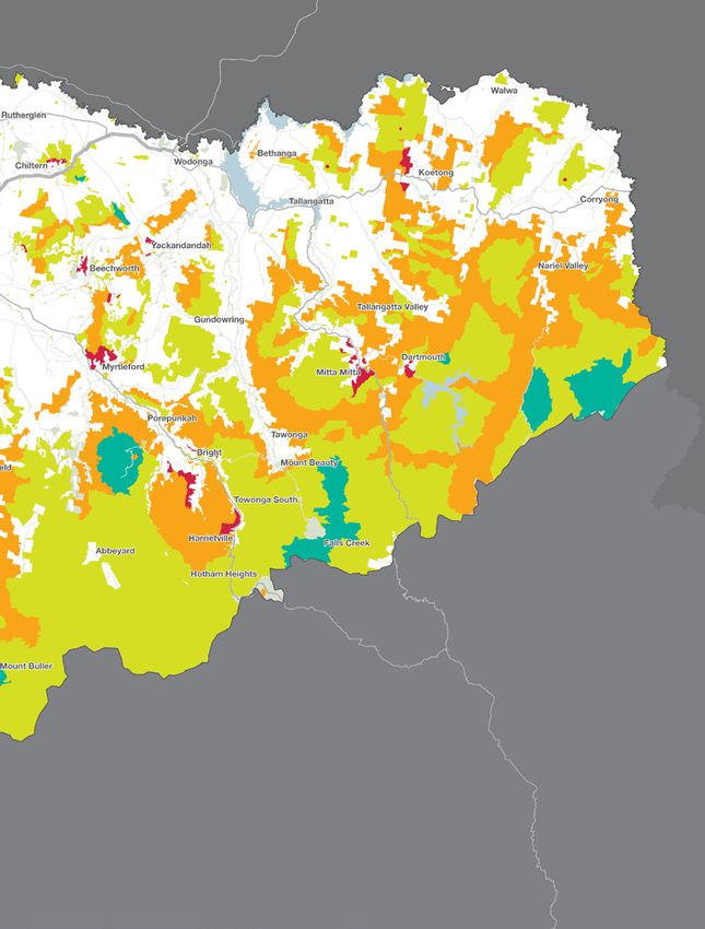
Contents
Introduction                                                                                                                                                                                      2

About bushfire in our landscape                                                                                                                                                                   4

What this plan prioritises for protection                                                                                                                                                         8

     How do we decide what to prioritise for protection?...................................................................................................................8
     Communities...............................................................................................................................................................................12
     Infrastructure and environmental services.................................................................................................................................12
     Economy......................................................................................................................................................................................13
     Environment................................................................................................................................................................................14
     Cultural heritage and community assets.....................................................................................................................................14

How we will protect our landscape                                                                                                                                                               15

Our fuel management strategy............................................................................................................................................... 15
     About our fuel management strategy.........................................................................................................................................15
     Reducing bushfire residual risk...................................................................................................................................................15
     Fire management zones..............................................................................................................................................................19
     Fire operations planning.............................................................................................................................................................21
     Balancing our fuel management approach.................................................................................................................................22

Other bushfire management strategies................................................................................................................................... 23
     Preventing bushfires....................................................................................................................................................................23
     Being prepared for bushfires.......................................................................................................................................................23
     Responding to bushfires..............................................................................................................................................................23
     Recovering after bushfires...........................................................................................................................................................23

How we will continuously improve the planning process                                                                                                                                           24

Glossary                                                                                                                                                                                        25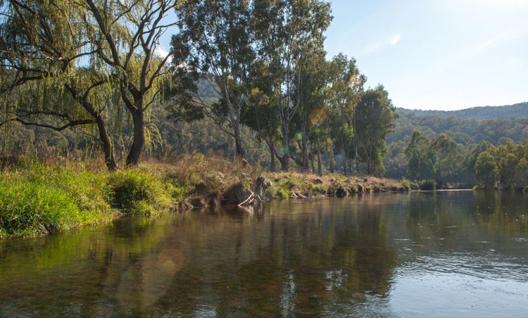
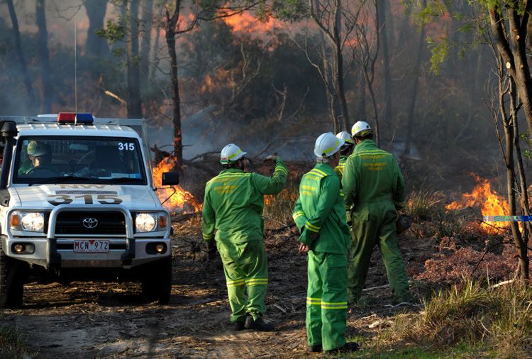
Helicopters are used to suppress fires in remote locations © DELWP

Introduction
Victoria is one of the most fire-prone areas in the world.      This plan explains the fuel management strategy that
In past decades, we have seen the disastrous effects that       we—DELWP and Parks Victoria (PV)—will undertake to
bushfires can have on communities — on people, properties,      minimise the impact of major bushfires on people, property,
our economy and the environment.                                infrastructure, economic activity and the environment, to
                                                                achieve the two code of practice objectives. It explains how
Under the Forests Act 1958, and in line with the Code of
                                                                we will do this by placing fire management zones—asset
Practice for Bushfire Management on Public Land 2012,
                                                                protection zones, bushfire moderation zones, landscape
the Department of Environment, Land, Water and Planning
                                                                management zones and planned burning exclusion zones—on
(DELWP) is responsible for managing bushfire risk on public
                                                                public land, and by doing other fuel management activities.
land. The code of practice’s two objectives are to:
                                                                History tells us a small number of major bushfires have caused
• minimise the impact of major bushfires on human life,
                                                                the greatest losses of human life, although any bushfire has
  communities, essential and community infrastructure,
                                                                the potential to result in loss of life and property. In some
  industries, the economy and the environment: human life
                                                                cases, major bushfires have also damaged fire-sensitive
  will be afforded priority over all other considerations
                                                                ecosystems and species.
• maintain or improve the resilience of natural ecosystems
                                                                As well as fuel management, the code of practice emphasises
  and their ability to deliver services such as biodiversity,
                                                                reducing bushfire risk through other strategies and actions
  water, carbon storage and forest products.
                                                                for:
The code of practice requires DELWP to undertake strategic
                                                                • prevention, to minimise the occurrence of bushfires,
bushfire management planning. This is the first strategic
                                                                  particularly those started by people
bushfire management plan for the Alpine and North East
bushfire risk landscape, one of Victoria’s seven bushfire       • preparation, so we are adequately prepared for bushfires
risk landscapes. The strategic planning approach we used          and can better respond to them when they occur
to develop this plan replaces our previous fire protection
                                                                • response, to ensure a timely and adequately resourced
planning approach.
                                                                  initial attack on all detected bushfires on public land
We developed this plan in the context of Victoria’s new
                                                                • recovery, to ensure we identify risks and damage resulting
emergency management arrangements. The Victorian
                                                                  from bushfires.
Government’s Emergency Management Reform White Paper
and subsequent legislation aim to build community resilience
through increased participation and shared responsibility.

2 Strategic bushfire management plan | Alpine and North East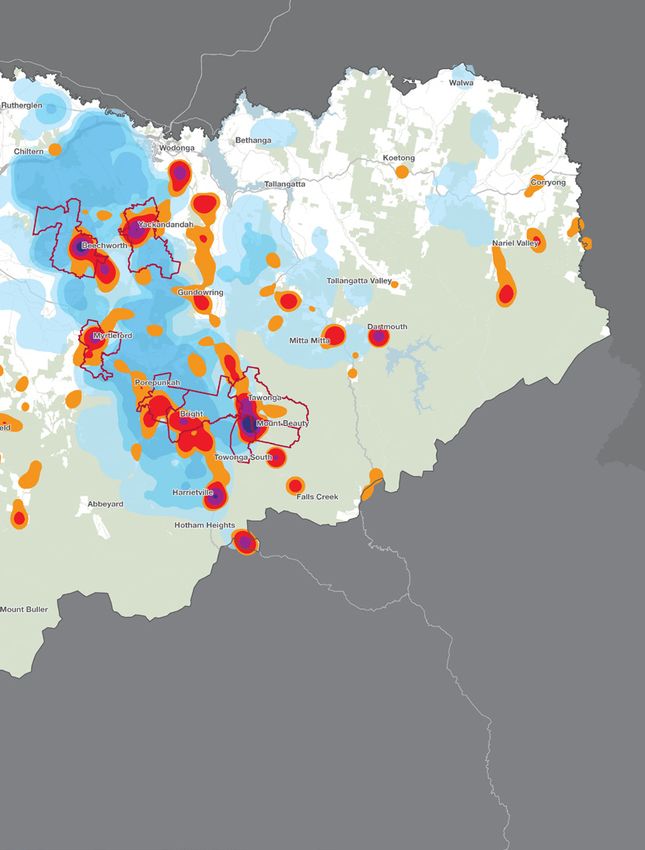
Craig’s Hut, atop Clear Hills in Mansfield State Park was burnt down in the 2007 bushfires and subsequently rebuilt by popular demand © Paul O’Connor

Over the next few years, with community and stakeholder                           Health and Human Services, local governments, catchment
engagement, we will refine and document risk-based                                management authorities, water corporations, utility services,
strategies for bushfire prevention, preparedness, response                        private land managers, regional industry advisors, cultural
and recovery.                                                                     heritage experts and communities in the landscape. DELWP
                                                                                  and PV will continue to work in partnership with the agencies
We use a risk-based approach to planning for bushfire
                                                                                  and organisations above, and with all other interested parties,
management, based on the International Standard for Risk
                                                                                  to reduce bushfire risk on public and private land. We will
Management ISO 31000. Our approach:
                                                                                  also encourage residents and land owners to find out about
• pairs local knowledge with world-leading bushfire                               bushfire risk on their property and have up-to-date bushfire
  simulation software, historical data and the best-available                     plans.
  science to understand how bushfires behave
                                                                                  We welcome this strategic, risk-based approach. As the
• incorporates the views of communities, industries and                           officers responsible for ensuring DELWP’s compliance with
  other stakeholders about what they value and want to                            the code of practice, and for effective strategic planning
  protect from bushfires                                                          and implementation at the regional level, we consider it will
                                                                                  result in better bushfire risk management, safer communities
• proposes ongoing monitoring, evaluation and reporting
                                                                                  and property, stronger local economies and more resilient
  about how implementation of our planning approach is
                                                                                  ecosystems.
  reducing bushfire risk.
                                                                                  This document is a summary of our planning approach, and
The international standard for risk management, with which
                                                                                  there is much information that sits behind it. To find out
our strategic planning approach complies, reflects the fact
                                                                                  more, including how you can be involved in reviews and
that risk can never be completely eliminated. Bushfires will
                                                                                  updates of the plan, visit www.delwp.vic.gov.au.
still occur, and everyone needs to be prepared and ready to
respond. But bushfire risk can be reduced with a high-quality
risk management approach.
We thank everyone who is contributing to our planning
approach. This includes staff and representatives of DELWP,
PV, VicForests, Country Fire Authority, Victoria Police, State
Emergency Service, Emergency Management Commissioner
and Emergency Management Victoria, Department of                                    Alan Goodwin                            Christine Ferguson
                                                                                    DELWP Chief Fire Officer                DELWP Regional Director
                                                                                                                            Hume

                                                                                                      Strategic bushfire management plan | Alpine and North East 3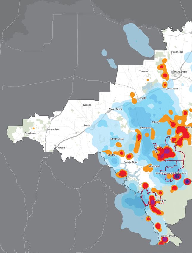
Mitta Mitta River © DELWP
About bushfire in our landscape
For strategic bushfire management planning purposes, DELWP destroyed, major economic disruption, infrastructure damage
and PV divide Victoria into seven bushfire risk landscapes. and environmental assets harmed. Major bushfires in our
These are areas where bushfire behaviour—including the landscape include the 1939 Black Friday fires (which burnt
types of places that bushfires start, the terrain and vegetation 940 312 ha), the 1952 Benalla-Moyhu fire (100 000 ha),
through which they spread, and the types of impact they the 1972 Mt Buffalo fire (12 140 ha), the 1985 Mt Buffalo
have—is sufficiently common to plan for the area as a whole. fire (51 400 ha) the 2003 Alpine fire (over 1 million ha), the
2006-07 Great Divide fires (441 517 ha), the 2009 Beechworth
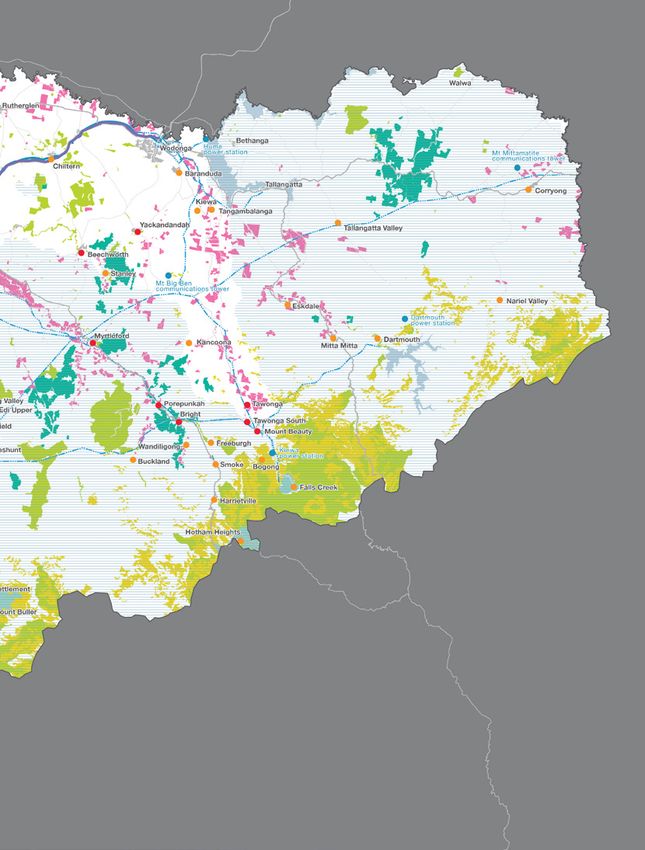
Map 1 shows the Alpine and North East bushfire risk
Library Road fire (33 577 ha) and the 2013 Harrietville fire
landscape. It is about 2 600 000 ha, or 11% of the state’s area.
(36 000 ha).
Of the landscape, 52% is public land, including extensive areas
of tall eucalypt forest rising up to the Great Dividing Range In the last decade, 51% of all bushfires in our landscape to
and the Victorian high country; 48% is private land, including which DELWP responded (and which were mostly on public
the alpine valleys and the floodplains and grasslands of the land) were due to lightning. Other bushfires were started by
Goulburn and Murray rivers. This variation in topography and machinery, trains, escapes from campfires and burn offs, and
land use influences how bushfires behave, the properties at other causes. Deliberate action by people accounted for 4%
risk, the type of assets and how we respond to fire. of bushfires, accidental ignitions 22% and the remaining 23%
had other or unknown causes.
Managing bushfire risk is essential. In the last 43 bushfire
seasons, DELWP responded to an average 110 bushfires a On Severe, Extreme and Code Red fire danger days, bushfires
year in our landscape. We suppressed 82% of these bushfires can start and spread quickly to become major bushfires.
before they grew to 5 ha. Rapidly detecting and suppressing Typically on such days, a strong north-westerly wind blows
bushfires before they grow to a size and intensity that makes hot, dry air from central Australia across Victoria. If a bushfire
them difficult to control is a core part of our approach to ignites, or is already burning, this wind can push it rapidly
managing bushfire risk. south-east, creating a relatively narrow fire front and long fire
flanks on its western and eastern sides. Then, an approaching
Since 1940, bushfires have resulted in 32 lives lost in our
cold front with a strong south-westerly wind can expand the
landscape: 24 to grassfires west of the Hume Freeway and
bushfire’s eastern flank into a wide fire front, and intensify
eight to bushfires in the more-forested, elevated areas in the
the fire. These weather conditions can create fast-moving
east. Most lives lost were those of firefighters. About twice
bushfires and powerful convection columns, which in turn
the number of houses have been lost east of the freeway
cause ember storms, wind-blown debris, downbursts, fire
than west of it. In the last 15 years, bushfires have increased
tornadoes and explosive balls of igniting eucalyptus vapour.
in size and intensity, burning millions of hectares of public
This was what we saw in Victoria on 16 February 1983 (Ash
and private land. These have resulted in lives lost, property
Wednesday) and 7 February 2009 (Black Saturday).
4 Strategic bushfire management plan | Alpine and North East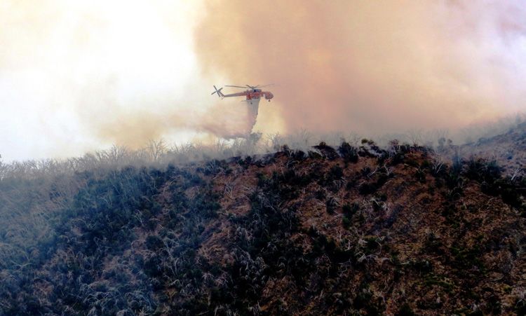
The Bluff, Alpine National Park © Rowhan Marshall

Climate change is increasing bushfire risk in Victoria and         • managing fuel around and next to priority assets
lengthening the average fire season. Climate change                  helps to minimise flame contact, radiant heat, ember
projections indicate that Victoria is likely to have up to 70%       generation and short-distance spotting potential. This fuel
more Severe, Extreme and Code Red days by 2050. We will              management can be difficult as it generally requires more
also likely have:                                                    resources and skills, and it may also rely on landowners
                                                                     making their properties as bushfire-safe as possible
• reduced average rainfall and streamflows
                                                                   • when a bushfire starts, we can use our knowledge of its
• fewer rainfall days (with heavier rainfall) and more
                                                                     likely spread paths and impacts to most effectively fight the
  consecutive dry days
                                                                     fire, and provide information to communities that may be
• more frequent and widespread droughts                              in its path.
• more days over 35°, and a higher annual mean                     Map 1 also shows where bushfire simulations predict
  temperature.                                                     bushfires would cause maximum damage to property. These
                                                                   locations have relatively high numbers of properties, and are
Climate change is also likely to alter the attributes and
                                                                   in the path of many simulated bushfires. The map shows the
availability of habitat for the landscape’s plants and animals.
                                                                   simulated property risk is highest around the communities
This will magnify existing threats such as fragmentation
                                                                   in the valleys and the surrounding hilly terrain in the Alpine,
(which isolates some species in particular areas) and loss of
                                                                   Indigo and Mansfield shires, particularly in the localities
habitat (such as hollow-bearing trees). It may also increase
                                                                   of Beechworth, Bright, Jamieson, Mt Beauty, Myrtleford,
the spread of some invasive species.
                                                                   Porepunkah, Sawmill Settlement/Merrijig, Tawonga, Tawonga
Map 1 shows the landscape’s bushfire catchments. These             South, Tolmie and Yackandandah. The communities in these
are areas where the worst bushfires could start, spread and        localities are in the paths of simulated bushfires with the
impact on priority communities and assets in a single day.         greatest level of potential impact. They are vulnerable to
These are important things to know because:                        bushfires starting at a variety of locations, and bushfires
                                                                   under worst-case weather conditions would result in the most
• at likely ignition points, we may conduct patrols on Severe,     properties lost.
  Extreme and Code Red fire danger days, and manage fuels
  (particularly if the spread or impact areas of these bushfires
  are difficult to treat)
• along spread paths, fuel management is the key to reducing
  the impact of major bushfires by reducing their spread and
  intensity

                                                                                  Strategic bushfire management plan | Alpine and North East 5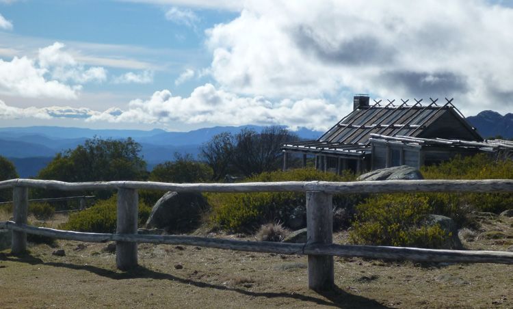
Map 1: Bushfire catchments and simulated property risk

6 Strategic bushfire management plan | Alpine and North East
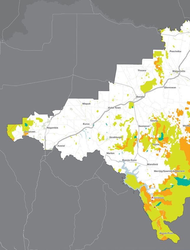
Simulated property risk:
                       Low
                       Moderate
                       High
                       Very high
                       Extreme

                 Major fire pathways:

                       Low impact
                       Moderate impact
                       High impact
                       Very high impact

                       Highest risk localities

                       Public land

                       Private land

                       Built-up areas

                       Main roads

                 0km          10km        20km

Strategic bushfire management plan | Alpine and North East 7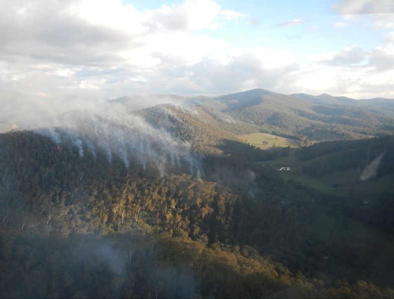
High fuel loads in the mountainous terrain in the east of the landscape can result in intense fires that are hard to suppress © DELWP

What this plan prioritises for protection
How do we decide what to                                                              We use PHOENIX RapidFire bushfire simulation software,
                                                                                      which is world-leading technology developed by The
prioritise for protection?                                                            University of Melbourne and the Bushfire and Natural Hazards
Our planning method is based on the International Standard                            Co-operative Research Centre, in conjunction with DELWP.
for Risk Management ISO 31000. The risk assessment process                            PHOENIX RapidFire simulates how bushfires spread from a
identifies the assets we consider important in our landscape,                         grid of ignition points across the landscape, given:
consistent with state fire control priorities: communities and                        • terrain and fuel (being a result of any location’s fire history,
properties, infrastructure and economic and environmental                               type of vegetation and modelled fuel accumulation) at the
assets. We then assess the asset’s risk, based on its likely                            starting point and along spread paths
exposure and vulnerability to a major bushfire, and how
consequential a major bushfire would be. That is, something                           • weather conditions (we use worst-case weather conditions
has a high risk rating if:                                                              similar to those in Victoria on Ash Wednesday 1983 and
                                                                                        Black Saturday 2009).
• it is very likely to be exposed to a major bushfire
                                                                                      Victorian Bushfire Risk Profiles provides more information
• it is vulnerable to fire: that is, if fire would damage and/or                      about how DELWP uses PHOENIX RapidFire to quantify risk.
  disrupt it
                                                                                      Map 2 compares PHOENIX Rapidfire’s simulation of the initial
• there would be consequences ranging from important to                               extent of the 2009 Beechworth–Library Road bushfire, and
  catastrophic if bushfire damaged or disrupted it.                                   the actual extent, about 12 hours after ignition. It shows that
Once we have identified the assets at highest risk from                               the fire, moving south-east, almost immediately encountered
bushfire, we design a fuel management strategy which                                  forest which was fuel-reduced by bushfire in 2003 and
prioritises those assets for protection.                                              planned burning in 2005 and 2008. The simulation shows
                                                                                      that without fuel reduction, the fire would have travelled 12
Our planning method draws on the best available information                           km further, potentially threatening the entire Ovens Valley
from data and community consultation. We use the Office of                            between Myrtleford and Bright. Fuel-reduced areas also
Emergency Services Commissioner’s Wildfire Project, regional                          provided safer anchor points for crews suppressing the fire
bushfire planning assessments, the Victorian Fire Risk Register                       and helped protect the Mt Big Ben telecommunications tower.
and state government data about environmental assets and
cultural heritage.
We consult with communities, stakeholders and experts.
This includes representatives of industry, land managers,
emergency services and local governments, and with a wide
range of experts including ecologists and cultural heritage
experts. We consult about our modelling tools, bushfire
behaviour, our risk assessment methods, the landscape’s
assets and the vulnerability of those assets. By drawing on
the knowledge and experience of local communities, we can
better understand what they value and how they see bushfire
risk, and engage with them in planning the best course of
action.

8 Strategic bushfire management plan | Alpine and North East
Many areas of private land in the landscape are surrounded by public land © Caitlin Cruikshank An historical site in Warby-Ovens National Park
© Caitlin Cruikshank
Map 2: Actual and simulated extent until 4am of 2009 Beechworth-Library Road fire
Ignition point
at 6pm 7th Feb 2009
Fuel-reduced areas in
six prior years
Fire extent at 4am 8th Feb 2009
Actual final extent
PHOENIX-predicted spread
with fuel reduction (fire intensity in
kW per metre):
1 - 4500
4500 - 10500
10500 +
PHOENIX-predicted spread
without fuel reduction
0km 2km
Strategic bushfire management plan | Alpine and North East 9Map 3: Our landscape’s priorities for protection
Fires caused by people are most common in the west: close to population
centres and popular camping areas along the Murray and Goulburn rivers.
Highest-risk communities
Cultural heritage sites (such as rock art sites) are nationally significant. They
Medium-risk communities exist throughout the landscape and can be fire-sensitive. Intense bushfires
can scour or crack the granite rock, and smoke can damage the art.
High-value environmental areas
High-value agricultural land
Apiarists put their beehives on public land throughout the year
High-voltage power transmission according to the different blossom times of various trees and
vegetation. We need to understand the long-term effects of planned
Priority infrastructure burning on the flowering trees and plants on which their bees rely.
Railway line
Hume Freeway Our landscape has many world-class wine-
growing areas including in the King Valley,
Water supply catchments Alpine Valley and around Glenrowan,
Rutherglen and Beechworth. Smoke from
Ash forest on public land
bushfires can taint the grapes and make
Softwood plantation the wines unmarketable. We work with
viticulturalists to avoid, as far as possible,
Alpine resort planned burning during key grape-growing
and harvesting periods.
Body of water
0km 10km 20km
On the plains, wind-driven grassfires can be fast-moving and can cover
large areas. They often threaten people and property at a distance from
communities. While they are serious fires, they are usually controlled within
24 hours of ignition. In 1952, a bushfire ignited on the Hume Highway near
Benalla. It burnt more than 100 000 ha, and several lives were lost.
Each year, our landscape attracts over 2.5 million tourists. Food services, accommodation and retail
are major employers in the landscape. Tourist attractions include the alpine resorts of Mt Hotham,
Mt Buller & Mt Stirling and Falls Creek which are located within our landscape. Road closures, smoke
and threats from bushfire can disrupt the tourism industry during peak summer holiday periods.
Alpine sphagnum bogs and associated fens (Alpine peatland) communities are nationally endangered and
include the nationally threatened Bogong eyebright, Alpine tree frog and the Booloolong frog. These vegetation
communities and associated threatened plants and animals are highly sensitive to fire and slow to recover.
Bushfires east of the Hume Highway are generally slower-moving, but the mountainous terrain,
heavier forest fuels and localised weather can create very intense bushfires that are difficult to
suppress. Forest fires can also generate spotting, a process whereby firebrands (such as tree
bark) are lifted on the bushfire’s updraft and carried downwind, sometimes for many kilometres.
Spotting can rapidly increase a fire’s rate of spread and breach containment lines.
10 Strategic bushfire management plan | Alpine and North EastPriority infrastructure such as the Mt Big Ben communications
tower is vulnerable to bushfire. We manage fuel near this tower
Most people in the landscape live in the major centres and others to limit disruption in the event of a bushfire.
along the Hume Freeway. These are surrounded by
generally flat farmland or open woodland, which is less
exposed to radiant heat or ember attack from bushfires.
Dartmouth Dam is the largest water
storage in the state and supplies the
Dartmouth Power Station. Other
hydroelectric generators include the
Eildon Power Station and the Kiewa
Hydroelectric Scheme. These assets need
protecting from bushfires.
Fragmented populations of the critically endangered
Mountain pygmy-possum live in the Australian Alps.
Major threats include the isolation and fragmentation
of these populations, introduced predators and climate
change (which is predicted to increase bushfires).
The 2003 Alpine fire, the 2006–07 Great Divide fires and
the 2013 Harrietville fire burnt 70% of our landscape.
Alpine ash forests are highly
exposed and vulnerable
The endangered Spotted
to bushfire. Alpine ash is
tree frog is found in discrete
a sought-after hardwood Planned burning in pine plantations is problematic:
populations in mountainous
which is harvested and pine is very flammable. Where these plantations
country, at a range of
regenerated in state forests. are close to communities, we may need to do other
altitudes. It is sensitive
Major bushfires in Alpine types of fuel management.
to fire because fire can
ash forests near the tops of
increase sediment inflows
water catchments can in the
causing water turbidity, and
short and long terms degrade
can damage or destroy its
the water quality and reduce
streamside habitat.
the yields of the catchments,
which provide inflows into the
Murray–Darling Basin.
Strategic bushfire management plan | Alpine and North East 11Our landscape’s 65 000 ha of softwood and native hardwood plantations have local, Smoke from fires can permeate the skin of grapes, and wine made from
state and national significance © DELWP smoke-tainted grapes may be unmarketable © Caitlin Cruikshank
Communities Infrastructure and environmental
Map 3 shows our landscape’s priority communities and their services
localities (including outlying properties). The code of practice Map 3 shows our landscape’s priority infrastructure: our water
prioritises minimising the impact of bushfires on human life supply catchments and major storages, freeways and highways,
over all other considerations. Communities at highest risk high-voltage transmission lines and communications networks.
in our landscape are those located in the forested hills and
valleys. Our water catchments and storages are of national significance
and include Lake Hume (the main operating storage of the
We prioritised these communities and their localities because Murray River system) and Dartmouth Dam (the largest water
modelling shows they would have the highest number storage in the state). Our catchments provide almost 40% of the
of houses lost in a major bushfire. The location of many inflows into the Murray–Darling system and also supply water
communities in our landscape increases their bushfire risk. to major irrigation districts, Adelaide and numerous other cities
Most cities and towns in the landscape have growing peri- and towns. Our landscape’s catchments also provide water for
urban areas, and the main towns to the east of the freeway hydroelectric generators, including the Eildon power station,
are developing toward heavily forested areas. Bushfires Kiewa power station and Dartmouth power station.
in these more heavily forested areas are more likely than
grassfires to generate the levels of intense heat or embers Our water supply catchments are vulnerable to bushfires which
that destroy houses. can damage water supply infrastructure and contaminate the
water with ash and debris. In some areas in the catchments,
Some communities and groups of people are more vulnerable post-bushfire landslides of water and debris can do further
to bushfire than others, including those who lack experience damage, and degrade water quality, if the terrain is steep and
of bushfire, summer visitors, people with disabilities or the soil is erodible.
illness, the elderly and people from non-English-speaking
backgrounds. These people and communities in particular Maintaining water flows in the Murray, Goulburn and Broken
tend to be less aware of bushfire risks, less prepared for river systems is important for water supply to major towns and
bushfire, and less able to quickly respond to it. These factors cities, for ecosystem resilience and for irrigation. The irrigation
can also compromise evacuation and firefighting efforts. infrastructure in the Goulburn and Broken river systems
supplies water for one of Australia’s major food-producing
To protect our priority communities, we: areas.
• place asset protection zones and bushfire management We prioritised our freeway and highway corridors including
zones in areas north and west of the communities in the the Hume and Goulburn Valley freeways; the Midland, Murray
likely spread paths of major bushfires Valley, Kiewa Valley and Omeo highways; and the Great Alpine
• place bushfire moderation zones to create strategic and Bogong High Plains roads. We also prioritised the four rail
fuel-reduced corridors along spread paths, to reduce the corridors that connect Melbourne, Sydney and southern New
intensity and rate of spread of major bushfires South Wales.
• provide advice to other land managers and fire agencies We prioritised our landscape’s high-voltage transmission lines.
about high-risk areas for other fire risk planning Direct flame contact, radiant heat and thick smoke can cause
preparedness activities such as conducting private land fuel arcing which can shut down electricity supplies and disrupt
reduction communities.
• increase patrols in high-fire-risk areas (including camping We prioritised key communications infrastructure including
areas) on high-fire-danger days. Airsevices Australia communications towers on Mt Big Ben,
Mt Mittamatite and Mt Hickey. We also considered emergency
communications and logistical networks, so that in the event of
a bushfire there is minimal disruption to essential services and
recovery works are not impeded afterwards.
12 Strategic bushfire management plan | Alpine and North EastThe critically endangered Mountain pygmy-possum is now only found in fragmented The landscape has many Aboriginal heritage sites © Caitlin Cruikshank
populations in the Victorian Alps © Jerry Alexander
To protect our priority infrastructure and environmental During the bushfire season, there are large influxes of people
services, we: into our landscape for camping, water sports and other
recreation activities. Bush camping is popular during the
• manage fuel in and around the upper reaches of our
summer holidays in the landscape’s valleys and beside its lakes
main water catchments to reduce the size and intensity of
and rivers, which are often in remote bush settings. Campers
bushfires in the fire-sensitive Alpine ash forests, and in and
can be at particular bushfire risk.
around areas which may generate mass debris flows after
major bushfires We prioritised primary production because 20% of Victoria’s
agriculture, forestry and fishing exports come from our
• provide information and advice to the owners and managers
landscape. 50% of the state’s fruit produce is grown in the
of prioritised infrastructure to inform their fuel and asset
Goulburn Valley and Shepparton area, which relies on water
management activities.
from our landscape’s catchments. Bushfires destroy and
damage buildings, fencing, machinery and equipment. They kill
Economy and injure livestock and damage productive plants, such as fruit
trees and grape vines. Smoke from fires can permeate the skin
Map 3 shows our landscape’s priority economic assets,
of fruits. The viticulture industry is particularly vulnerable as
which are the tourism industry, plantation timber and native
wine made from smoke-tainted grapes may be unmarketable.
hardwood resources, and agriculture.
Bushfires also damage the natural environments and
We prioritised plantation timber and native hardwood (Alpine infrastructure on which tourism industries rely.
ash) areas because they are highly exposed and vulnerable to
To protect our priority economic assets, where practicable we:
bushfires. Our landscape has 65 000 ha of softwood plantations
and native hardwood resources, both of which have local, state • place bushfire management zones next to plantations, to
and national significance. They also provide the raw material reduce the likelihood of fire spreading into them, and conduct
for several wood processing plants in our landscape. Our more frequent burning in them if required to maintain
plantations are located in clusters across our foothill country appropriate fuel hazard levels
and are usually adjacent to native forest. Communities next to
pine plantations are at increased bushfire risk because they are • place asset protection zones to the north-west of plantations,
highly flammable and provide continuity of fuel for spreading in the spread paths of likely major bushfires
bushfires. Also, plantations cannot be effectively planned • place bushfire management zones to create a network of
burned. strategic fuel-reduced corridors , to reduce the spread of
Mature native hardwood forests to be harvested are at the bushfires and reduce potential impacts on the primary
most risk from bushfires because they are the highest-value production and tourism industries (including bushfire smoke
timber asset in our landscape. Also, if a bushfire burns large and long periods of disruption)
areas of Alpine ash in the water catchments, the water yield • include high-value native hardwood areas in planned burning
will drop: areas of regenerating Alpine ash do not yield as much exclusion zones, or in landscape management zones with
water, and the water may be poorer-quality. reduced planned burning frequency, if it is not conflicting
We prioritised the tourism industry because bushfires damage with bushfire risk to communities
the natural environments which attract tourists and the • place bushfire management zones north and west of large
infrastructure they use. The threat of bushfires may also deter areas of private land, and more frequently burn these areas
them from visiting forested areas. Each year, our landscape
attracts over 2.5 million tourists. Food services, accommodation • place bushfire management zones on the north-west slopes
and retail are major employers and particularly in the Alpine of mountain ranges, if there are assets to the south-east that
and Mansfield shires, which are also at the highest risk from would be at risk of ember showers from an uphill run of fire
bushfires. on the slopes
• include prioritised tourist assets in landscape management
zones or planned burning exclusion zones.
Strategic bushfire management plan | Alpine and North East 13Environment • exclude HVEAs and other important ecological assets
in our landscape during planned burning or other fuel
Map 3 shows our landscape’s high-value ecological areas management activities
(HVEAs). These are areas where the most fire-sensitive plants,
animals and vegetation communities occur. These areas are • provide other land managers with information about
sensitive to fire because it can cause direct loss of species and important ecological assets on their land.
loss of habitat (such as hollow-bearing trees for large owls,
and food sources for Mountain pygmy possums). Fire can Cultural heritage and community assets
also cause waterway and wetland turbidity affecting aquatic
species such as Alpine tree frog and Barred galaxias. Also, too- Our landscape’s history stretches back thousands of
frequent fire can disrupt the ability of many species to reach generations and includes the use of fire by Aboriginal people
maturity and successfully reproduce. for environmental, economic and social purposes. Our
landscape has thousands of Aboriginal cultural heritage sites
HVEAs also include nationally listed threatened vegetation including ceremonial gathering places, shell middens, burial
communities including Alpine bog and associated fens, and sites, scar trees, artefact scatters, stone quarries, rock shelters
Box gum woodlands and grasslands. and rock art sites. As only about 5% of Victoria has been
formally assessed for cultural heritage evidence, the number
We prioritised our landscape’s sizeable areas of wet forest,
of recognised sites will continue to grow, particularly in our
including fire-sensitive Alpine ash. Alpine ash is important for
landscape which has large tracts of forest.
healthy water catchments and is habitat for the threatened
Leadbeater’s possum, such as in a small section of wet forest Bushfire risk management must draw on the wisdom
near Woods Point. While fire is part of this natural system, and experience of Aboriginal land management regimes
planned burning is difficult in wet forests as they are usually and support Aboriginal people to rebuild and maintain
too damp, and when they do dry out in summer the fuel loads connections to Country.
are usually too extreme to safely control a planned burn. For
this reason, we reduce fuel hazard in adjoining drier forests There are three registered Aboriginal parties in our landscape:
and aggressively attack any fire outbreaks in them. Taungurung Clans Aboriginal Corporation, the Yorta Yorta
Nation Aboriginal Corporation and the Gunaikurnai Land and
We prioritised some ecological fire groups (EFGs) that are Waters Aboriginal Corporation. We will continue to work with
most vulnerable to too-frequent or too-intense fires. EFGs are these parties to ensure the best possible protection of our
groupings of ecological vegetation classes that have common cultural heritage.
ecological requirements for fire, and common fire behaviour
characteristics. Fire-sensitive EFGs are often where we find The landscape’s non-Aboriginal cultural heritage dates to
fire-sensitive plants and animals. For example, fire-sensitive the 1820s when the high country cattlemen started building
High-altitude shrubland/woodland is where we most often their rough huts, some of which still stand. In the early 1850s,
find threatened species such as Bogong eyebright, Snow people flocked to the region from around the world looking
daphne and Alpine water skink. On the plains, the threatened for gold, particularly to the alpine valleys and high country,
Squirrel glider and Lace monitor occur in the fire-sensitive and to the Chiltern and Rutherglen areas. Many heritage sites
Riverine woodland/forest EFG. remain from this period, including those of the Chinese.
We also prioritised long-undisturbed areas of native Community assets such as recreation reserves and community
vegetation. Large bushfires in 2003 and 2006–07, logging halls are also part of our landscape’s cultural heritage and
and increased planned burning have greatly reduced these have important social value.
areas. The remaining areas help to maintain and enhance To protect our priority cultural heritage and community
our landscape’s ecosystem resilience. Old growth forests and assets, we:
woodlands provide a variety of habitats for species such as
Leadbeater’s possum, Squirrel glider and Powerful owl. • where possible, include them in a landscape management
zone or planned burning exclusion zone
To protect our priority environmental assets, we:
• do planned burning near to fire-sensitive sites, to reduce
• where possible, include HVEAs in a landscape management the impacts of bushfire
zone or planned burning exclusion zone. Landscape
management zones are larger areas in which there may • protect known cultural heritage sites from disturbance
be widely dispersed ecological assets. We manage these when we manage the fuel load, and when we fight
zones for ecological and fuel reduction outcomes. Planned bushfires
burning exclusion zones usually cover smaller areas where • keep a watch out for, and record the details of, any new
ecological assets are more concentrated, it is practical to sites; only a very small percentage of Victoria’s area has
place a boundary, and it doesn’t conflict with bushfire risk been formally assessed for evidence of Aboriginal cultural
to communities heritage.
• identify where HVEAs are on the likely spread paths of
major bushfires towards other priority assets
• identify conflicts between planned burning to protect
other assets and the fire-sensitivity of the species and
communities in the HVEA
14 Strategic bushfire management plan | Alpine and North EastHow we will protect our landscape
Our fuel management strategy
About our fuel management strategy The main fuel management action is planned burning, which
is deliberate burning to reduce the quantity of leaf litter,
In our landscape, the bushfire risk to life and property is twigs, bark and undergrowth. It is the most effective method
7% of Victoria’s total risk. Our larger communities (Benalla, of managing fuel on large areas of public land, and the main
Wangaratta and Wodonga) are located along the Hume way we reduce bushfire risk. Fuel management also serves
Freeway corridor and have lower bushfire risk than our smaller ecosystem resilience purposes, such as regeneration of plant
communities, particularly those in the forested hills and valleys. species and habitat. Where appropriate, we may also manage
The residual risk to life and property in our landscape has fuel by slashing, mowing, mulching, applying herbicide and
reduced in recent decades due to major bushfires and grazing.
increased planned burning, but residual risk remains high in To develop our fuel management strategy, we combined our
some areas. These are areas we cannot effectively planned knowledge of bushfire behaviour and PHOENIX RapidFire
burn (such as pine plantations and wet forest), or areas where simulations with our prioritisation of human life and
the risk arises from fast-moving grassfires on private land— communities, infrastructure and environmental services,
which we do not manage—although we do work closely with economic assets, environmental assets and cultural heritage
local governments, CFA and communities as they reduce risk on and community assets.
private land.
Where we can, we manage the fuel hazard on public land close Reducing bushfire residual risk
to towns to reduce the intensity of, and ember attack from,
Residual risk is the risk, on average and across the whole
major bushfires. Further away, we focus fuel management on
landscape—including public and private land—that bushfires
the likely spread paths and the worst ignition areas for major
will impact on life, property or other assets. It is expressed as
bushfires.
the percentage of the risk that remains after bushfire history
We prioritise for protection those communities at the highest and fuel management (mainly planned burning) activities are
risk in the worst bushfire weather, but we also consider all taken into account. For example, 80% residual risk means that
our communities because we know that bushfires could ignite the risk of property and infrastructure being impacted by a
from, spread to and potentially impact most areas. bushfire—on average, throughout the landscape—is 20% less
than it would have been had we never had bushfires and fuel
We prioritise all assets using objective risk assessment methods
management to reduce the fuel hazard. The complex mosaic
to inform our fuel management strategy.
of fuel-managed and bushfire-burned patches—with different
Our landscape has some of the largest national parks and times since the last fire—across the landscape is mainly
reserves in Victoria. They contain a high level of biodiversity, what determines residual risk at any point in time. Residual
but some areas are also highly flammable. Inappropriate fire risk changes constantly as bushfires burn new areas, as we
regimes can threaten fire-sensitive animal and plant species, manage fuel, and as fuel accumulates.
as well as whole ecological communities. Our strategy aims to
One way DELWP measures the effectiveness of the fuel
mitigate this threat.
management strategy is by how well it reduces residual risk.
Our fuel management strategy comprises: PHOENIX RapidFire allows us to simulate the reduction in
residual risk at any particular location, at a particular point of
• fire management zones, which establish our long-term
time, if we reduce fuel load at the ignition points and along
balanced fire regime on public land by defining objectives
the spread paths of bushfires that could impact on it.
for fuel management across the landscape
Annual fuel management activities will be guided by a long-
• a balanced fuel management approach across the
term residual risk target.
landscape to ensure that planned burning to protect life
and property does not unduly damage other priorities.
The fuel management strategy aims to ensure that:
• through to 2050, as fuel reaccumulates in forests burnt in 2003, 2006–07, 2009 and 2013, residual risk to life and
property does not return to pre–2003 levels, but is kept below 60%
• through to 2050, we continue to reduce the residual risk to life and property, while maintaining a balanced approach to
protecting other assets.
Strategic bushfire management plan | Alpine and North East 15Map 4: Fuel management strategy
We place asset protection zones north and west of prioritised
communities and assets in the likely spread paths of major
bushfires. These zones have adjoining bushfire moderation zones,
which increase their effectiveness. We will treat fuel hazard in
these areas more frequently than other zones.
Maintaining forest roads and river tracks for
vehicle access and slashing along priority tracks
help us respond quickly to bushfires. Campfire
escapes can cause bushfires, so we regularly
patrol river camping sites during high-fire-
danger periods.
Sometimes, strategic bushfire management objectives—minimising risk to
communities, and protecting fire-sensitive plant and animal communities--
conflict. We aim to balance competing objectives, for example, by placing a
bushfire moderation zone but doing planned burning in it less frequently, and
by excluding fire-sensitive areas from planned burns where we can. We will
monitor this area closely, to improve how we balance competing objectives.
16 Strategic bushfire management plan | Alpine and North EastWe place bushfire moderation zones north and west of prioritised
communities and assets (such as the softwood plantations around
Koetong) in the likely spread paths of major bushfires.
We manage fuel near the
Mt Mittamatite and Air services
Australia communications tower
and fire tower, and other prioritised
infrastructure, to limit disruption in
the event of a bushfire.
We place bushfire moderation zones along the
likely spread paths of bushfires approaching
from the north and west, to create fuel-reduced
corridors. We treat these corridors a bit less
frequently than we do bushfire moderation
zones that have prioritised communities or
assets directly south-west of them.
To reduce the risk of Where protecting high-value
environmental areas is the priority, Asset protection zone
powerlines igniting bushfires,
or of bushfires disrupting the most fire-sensitive species
Bushfire moderation zone
the power supply, we place and vegetation classes guide the
bushfire moderation zones frequency of our planned burning. Landscape management zone
where powerlines are in the
likely spread paths of major Planned burning exclusion zone
bushfires. We manage fuel in
these areas frequently. Public land
Private land
Main roads
0km 10km 20km
Strategic bushfire management plan | Alpine and North East 17Figure 1 shows measured and expected residual risk in our by repeated burning, or for other reasons (such as fuel
landscape from 1980 through to 2050. It shows residual and weather conditions limiting the number of days in any
risk (the blue line and shaded darker blue area) decreased given year we can safely do planned burning). Also, in some
after the 2003 Alpine fire to 55%, returning to 60% by 2006. areas, the environmental damage that would result would
The 2006–07 bushfires then reduced residual risk to 43%, outweigh any small temporary reductions in risk we achieved.
while the 2009 fires resulted in a further reduction to 40%, For example, wet forest is usually too wet to burn in most
a historic low. Residual risk subsequently rose evenly as fuel seasons, and particularly in planned burning periods. It does
reaccumulated on burnt areas. By implementing our fuel not burn unless there are extended periods of dryness (such
management strategy on public land, residual risk can be as during droughts) but it is neither safe nor practical to do
maintained on average at 46% toward 2050. planned burns during those times.
The exact residual risk in future will depend on where we The figure also shows (the red dotted line) that fuel
schedule our planned burns each year within the zones; the management on private land could further reduce residual
size, intensity and location of bushfires when they occur; risk, theoretically reducing it to below 5%. This 5% is from
and how quickly fuel re-accumulates in burnt areas. We have fuel hazard on private land which cannot be treated by fuel
forecast the future residual risk using PHOENIX RapidFire management. In areas near priority communities with little
bushfire simulation software and multiple planned burning public land that can be safely burned, fuel management
scenarios. The uncertainty of all the factors that influence by private land owners and managers is key to reducing
residual risk reduces our ability to pinpoint exactly what bushfire risk.
residual risk will be in the future. However, continuous
DELWP will support other agencies (mainly CFA and local
improvement in our planning methods and operations should
governments) and landowners to prioritise and focus their
see residual risk decrease towards the lower end of the
fuel management activities on the highest-priority areas of
indicated range.
private land. Local governments can also use our information
The figure shows (the green dotted line) that planned burning and products when developing their own strategies for
on public land could theoretically reduce residual risk to as managing risk on private land.
low as 10%. However, this would require us to treat all public
That there is a small amount of risk which cannot be
land every year, which is not realistic. It is also not possible
treated by fuel management highlights the importance
to treat all areas of public land because some areas are
of other bushfire management strategies for prevention,
inaccessible, because it is not safe to manage fuels on some,
preparedness, response and recovery.
because fire-sensitive ecosystem areas could be threatened
Figure 1: Residual risk 1980–2050
100%
90%
80%
70%
60%
Residual risk
50%
Expected range of risk reduction
after implementing our strategy
40%
30%
Maximum risk reduction if all
public land was treated
20%
Risk that can’t be reduced
by fuel management
10%
Maximum risk reduction if all public and private land was treated
0
1980
1982
1984
1986
1988
1990
1992
1994
1996
1998
2000
2002
2003
2004
2005
2006
2007
2008
2009
2010
2011
2012
2013
2014
2015
2020
2025
2030
2035
2040
2045
2050
Residual risk Maximum risk reduction Maximum risk reduction if all public
if all public land was treated and private land was treated
Note: The expected range and theoretical maximum levels of risk reduction to human life and property shown in this figure were simulated under a weather
scenario of a Forest Fire Danger Index of 130.
18 Strategic bushfire management plan | Alpine and North EastSupervising a planned burn at Bonegilla in 2014 © Amy Warnock
Fire management zones In bushfire moderation zones, we aim to reduce the fuel
hazard about every 8–15 years over about 375 000 ha. We will
Fire management zones (FMZs) define objectives for burn areas within this zone that have higher bushfire risk (due
fuel management across the landscape. FMZs were first to their location or fuel load) or are on the likely spread paths
established in Victoria in 1995 and outline how frequently of bushfires, more frequently. In the other areas of these
to treat areas. We will review and adjust FMZs occasionally, zones, we will also consider ecological objectives.
as new technology, science and information become available.
This plan incorporates the outcomes of a review of our In landscape management zones, we will do planned burning
landscape’s FMZs. mainly to maintain and improve ecosystem resilience, but also
to reduce the fuel hazard, over about 750 000 ha. We will use
There are four types of FMZs. They are: the tolerable fire interval of fire-sensitive vegetation in these
• Asset Protection Zone: an area around properties and zones to determine the frequency of planned burning. This
infrastructure where we do intensive fuel management to means that in particular areas of these zones the frequencies
provide localised protection against radiant heat and ember of burning may be very different (varying from 15 to more-
attack in the event of a bushfire than-50 years), acknowledging that some areas are more
fire-sensitive than others, and that some also contribute to
• Bushfire Moderation Zone: an area where we manage fuel reducing risk to communities and assets.
hazard to reduce the speed and intensity of bushfires, and
to protect nearby assets, particularly from ember attack in
the event of a bushfire
• Landscape Management Zone: an area where we manage
fuel to reduce residual risk, improve ecosystem resilience,
and for other purposes (such as to regenerate forests and
protect water catchments)
• Planned Burning Exclusion Zone: an area where we try
to avoid planned burning, mainly because the vegetation
cannot tolerate fire, or because we cannot burn it safely
(such as wet forests).
Map 4 shows the location of FMZs in our landscape.
In asset protection zones, we aim to reduce the fuel hazard
by planned burning or other methods about every 5–7 years,
over about 9300 ha. If fuel accumulates and the fuel hazard
increases more rapidly, we will burn more frequently.
Strategic bushfire management plan | Alpine and North East 19Fire management zones in the Warby-Ovens National Park
The Warby Ranges are in the Warby-Ovens National Park, west The area is at-risk from fast-moving grassfires entering the
of Wangaratta. The ranges’ vegetation includes the Granitic ranges from the west and then potentially dropping embers
hillslopes, Grassy/heathy dry forest and Box ironbark forest onto Wangaratta or Glenrowan. Simulations also show that
ecological fire groups. Most of this area is long-undisturbed on high-fire-danger days, properties on the west side of the
by fire. The ranges also contain fire-sensitive ecological areas, ranges close to the forest are at risk because while the forest
Aboriginal cultural sites, recreation areas and infrastructure could slow the rate of spread, the fuel load would increase the
including communications and fire towers. Fire-sensitive fire’s intensity. This was the case near Boweya in December
fauna in the area include the Lace monitor, Carpet python 2014 when a grassfire ignited by lightning near Lake Rowan
and Regent honeyeater. There is expanding peri-urban travelled west through farmland and reached the Warby
development east of the park, and agricultural areas including Ranges. A planned burn in 2014 helped reduce the fire’s
for grazing, cropping, orchards and vines. spread once it reached the national park. Without the planned
burn, the fire could have spread further and may have
threatened the communities east of the ranges.
Map 5: Fire management zones in the Warby-Ovens National Park
Along the western
side of the Warby Fire Management Zones
- Public Land
Ranges, we
place corridors Landscape management zone
of bushfire
moderation Bushfire moderation zone
zones. We do
planned burning
in these corridors
more often, to Park boundary
reduce the spread
High value agricultural land
and severity of
potential grassfires Built-up areas
that could enter
the national park Main roads
from the west.
Bodies of water
We put a corridor
of bushfire
moderation zone
here to break the
spread of a north-
south bushfire
and help agencies
suppress fires along
roads between
Wangaratta,
Thoona and We place landscape
Boweya. management zones on
the east side of the park
where there is a lower
We put a landscape risk of fire spreading into
management properties, and there
zone here, where are more high-value
fire-sensitive White ecological areas.
cypress pine grows.
Fuel accumulation
in this type of
vegetation is slow,
so regular planned
burning would not
reduce risk in this
area.
We consider the needs We manage fuel close to
of vignerons when we infrastructure (such as the
do planned burning in State Mobile Radio tower
this area: the grapes are on Mt Glenrowan) to
susceptible to smoke protect it from bushfires.
taint from long periods
of dense smoke.
20 Strategic bushfire management plan | Alpine and North EastYou can also read