Nopiming Provincial Park - Draft Management Plan - Wilderness Committee
←
→
Page content transcription
If your browser does not render page correctly, please read the page content below
Nopiming
Provincial Park
Draft Management Plan
2 | Nopiming Provincial Park

Table of Contents
1.0 Introduction......................................................................3

2.0 Background Information...................................................4

3.0 Park Purpose and Role.....................................................5

4.0 Park Features: Strategic Objectives
		 and Proposed Guidelines.................................................8
      4.1 Natural Features............................................................................................8
   		       4.1.1 Natural Features: Strategic Objectives and Proposed Guidelines..........12
      4.2 Recreational Use..........................................................................................14
   		       4.2.1 Recreational Use: Strategic Objectives and Guidelines..........................18
      4.3 Commercial Resource Use............................................................................23
   		       4.3.1 Commercial Resource Use: Strategic Objective and Guidelines.............24
      4.4 Cultural Features..........................................................................................25
   		       4.4.1 Cultural Features: Strategic Objectives and Proposed Guidelines.........26
      4.5 Interpretation................................................................................................27
   		       4.5.1 Interpretation: Strategic Objectives and Proposed Guidelines..............28

5.0 Bibliography....................................................................29

This draft plan was prepared for Nopiming Provincial Park in consultation
with park users under the authority of The Provincial Parks Act.

Manitoba Conservation and Water Stewardship
Parks and Protected Spaces Branch

Fall 2015
Draft Management Plan | 3

                                                    Generally, the preparation of a park management
                                                    plan is divided into five steps:
                                                    Step 1: Identification of management issues and
                                                    					 public consultation (Phase 1).
                                                    Step 2: Distribution of a report on public comments.
                                                    Step 3: Preparation of a draft management plan.
                                                    Step 4: Public consultation (Phase 2) and review
                                                    					 of a draft management plan.
                                                    Step 5: Revisions and finalization the management plan.

                                                    In fall of 2014, phase one of public consultation was
                                                    held in conjunction with the Manigotagan River park
                                                    management plan process. Approximately 300
                                                    responses in total were submitted for both Nopiming
                          Nopiming                  and Manigotagan River. These comments along with
                          Provincial Park           scientific data, academic resources, and current park
                                                    policies and principles were considered during the
                                                    winter of 2015. This document is the draft plan that
                                                    was developed in steps one and two. With a draft
                                                    plan complete, the second phase of public
1.0 Introduction                                    consultation will begin. After the consultation and
The Provincial Parks Act (2015) requires that a     review of the draft plan, the management plan will
management plan be prepared for each provincial     be finalized. It is anticipated that the plan will be
park. Management plans establish long-term          completed in 2016. The process of preparing this
direction for parks and address issues pertaining   draft management plan and co-ordinating the public
to resource protection, use and development         involvement is the responsibility of a team involving
of park land. The draft management plan for         staff from Parks and Protected Spaces branch and
Nopiming Provincial Park is based on its role in    regional staff of Manitoba Conservation and
Manitoba’s system of parks and the participation    Water Stewardship.
of those who use and care about the park and        Once finalized, the management plan will guide
people who wish to provide input into park          the work of Manitoba Conservation and Water
management. The final plan is to be used in         Stewardship over the next 10 to 15 years. In this
conjunction with park regulations, directives,      context the plan will be used and examined on an
and other departmental and government policies      ongoing basis. When an update or new direction
and legislation. The completed plan will replace    on any matters described in this management plan
the Nopiming Provincial Park Interim Management     may be needed, a process for publicly reviewing
Guidelines (last updated in 1988).                  and updating the plan will be undertaken.

                                                    The Treaty and Aboriginal rights of Aboriginal
                                                    peoples to pursue traditional uses and activities
                                                    within Nopiming Provincial Park are acknowledged
                                                    and respected within the context of this draft
                                                    management plan.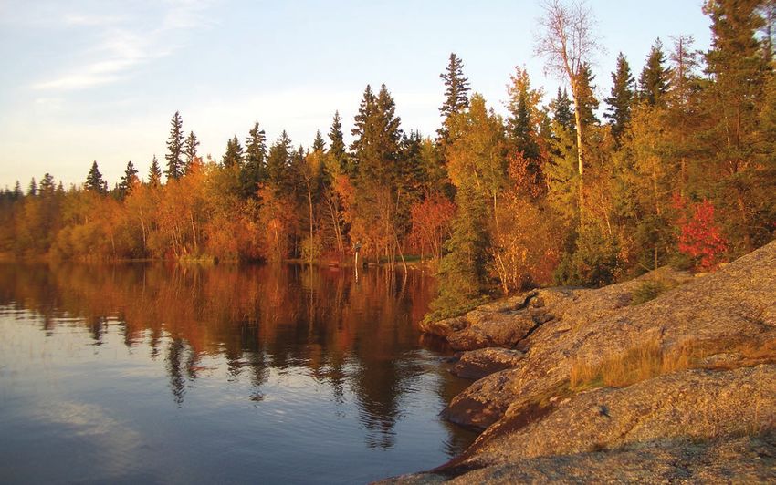
4 | Nopiming Provincial Park

2.0 Background Information
Nopiming Provincial Park was established in 1976.          of the park makes Nopiming a transition area from
Nopiming is the Anishinabe word for “entrance to           the developed and populated Whiteshell into the
the wilderness” and is indicative of the land, as until    more remote wilderness of Atikaki.
the 1970s, most of Nopiming was accessible only by
                                                           With over a hundred lakes and numerous rivers, the
water, bush plane or winter roads. Today, the park is
                                                           Nopiming area was a natural destination for the first
situated in the middle of a series of parks along the
                                                           peoples of the area, as well as an important area for
eastern Manitoba border with two of the largest in
                                                           wildlife. People were drawn by the lure of gold in
the chain being Whiteshell Provincial Park to the south
                                                           the early 1900s; this was the impetus for later
and Atikaki Provincial Park to the north. As well, there
                                                           development. The history of the landscape on
are very few major roadways in Nopiming Provincial
                                                           which the park sits begins billions of years ago with
Park – highway 314 runs north to south (and intersects
                                                           the formation of the Canadian Shield and has gone
with highway 304 at the northern edge of the park)
                                                           through many changes. The total area of the park
and highway 315 which runs east in the southern
                                                           is 1,429.1 square kilometres, which includes cottage
portion of the park. Both highways act as dispersal
                                                           areas, campsites and backcountry routes while
points for activities in Nopiming. The remote nature
                                                           also providing habitat for a variety of wildlife.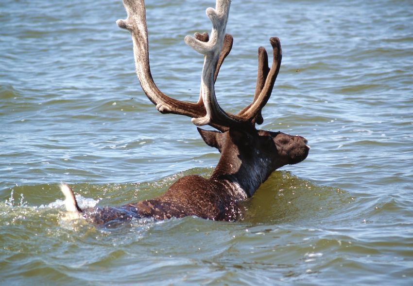
Draft Management Plan | 5
3.0 Park Purpose and Role
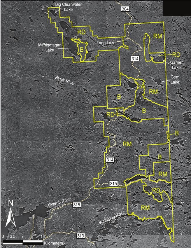
Under the authority of The Provincial Parks Act (2015) The Backcountry LUC (B) protects natural areas
Nopiming is classified as a Natural Park. Natural parks including boreal forest communities and woodland
are intended to both preserve areas of an ecoregion caribou habitat, including notable calving areas.
and accommodate a diversity of recreational It provides nature-oriented recreational opportunities
opportunities and resource uses. A System Plan such as canoeing, fishing, backcountry camping and
for Manitoba Parks (2015) describes the purpose remote hunting/fishing out camps. The Backcountry
and role of each provincial park in Manitoba. LUC comprises 27,301 hectares or 19 per cent of
The purpose of Nopiming Provincial Park is to the park.
preserve areas representative of the Lac Seul
The Recreational Development LUC (RD)
Upland Ecoregion (a portion of the Precambrian
accommodates intensive recreational facilities such
Boreal Forest Natural Region) and to accommodate
as campgrounds, commercial lodges, recreational
a diversity of recreational opportunities and
staging areas, cottage subdivisions and special
resource uses.
consideration organizations. Commercial resource
In addition, the park will: use in this area is permitted while recognizing the
• preserve areas of habitat for the threatened recreational values of the park. This LUC comprises
woodland caribou 27,526 hectares or 19 per cent of the park.
• provide nature-oriented recreational opportunities The Resource Management LUC (RM) permits
such as canoeing, hiking and mountain biking in commercial resource opportunities such as mining
a largely undisturbed environment and wild rice and bait fish harvest. It also provides
• provide high quality cottaging, camping, boating recreational opportunities including fishing, canoe
and fishing opportunities, and accommodate routes, trails, recreational roads, interpretive signs
related facilities and services and existing remote cottages. This LUC comprises
88,040 hectares or 62 per cent of the park.
• promote public appreciation and understanding
of Nopiming’s natural and cultural heritage The Access LUC accommodates PTH 314 through
• accommodate commercial resource uses such as the Backcountry LUC, and consists of 43 hectares
mining where such activities do not compromise or less than one per cent of the park.
other park purposes
Nopiming Provincial Park is divided into four land
use categories (LUC) as shown on Map 1. These land
use categories further define the purpose of specific
areas of the park.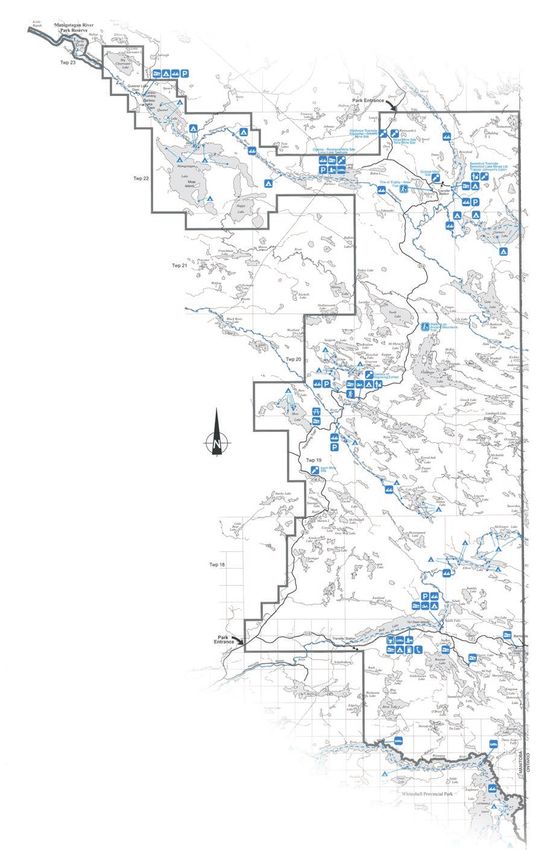
6 | Nopiming Provincial Park

     Map 1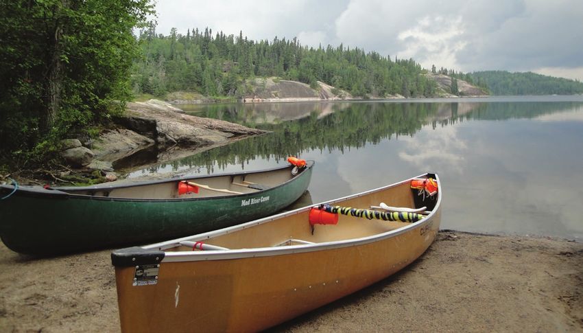
Draft Management Plan | 7
Nopiming Provincial Park and Interprovincial Wilderness Area
Manitoba’s Protected Areas Network
Recognizing the value and ecological importance
Nopiming Provincial Park contributes to Manitoba’s of this boreal wilderness area, the Ontario Ministry
Network of Protected Areas, which is made up of of Natural Resources and Manitoba Conservation
land, freshwater and marine areas that contain the and Water Stewardship have established the Manitoba-
tremendous biological diversity and unique features Ontario Interprovincial Wilderness Area. Manitoba
found in Manitoba’s varied landscapes. Currently, and Ontario are committed to working together to
19 per cent of the park is classified as Backcountry conserve the ecological integrity of this area,
LUC. Lands included in a Backcountry LUC contribute which encompasses over 9,400 square kilometres
to Manitoba’s network of protected areas and legally and includes Woodland Caribou Provincial Park and
prohibit commercial logging, mining, hydroelectric the Eagle-Snowshoe Conservation Reserve in Ontario,
development, oil and gas development, peat and Atikaki Provincial Park and parts of Nopiming
harvesting and any other activities that may Provincial Park in Manitoba. By managing this cluster
significantly or adversely affect habitat. of parks and wilderness lands as a single land area,
conservation of an integral part of Canada’s central
Manitoba’s goal is to create a network of protected boreal uplands will be strengthened now, and in
lands that represents the biodiversity in each of its the future.
16 ecoregions. Enduring Features are a collection
of landscape types, each characterized by a unique
combination of soils and surficial geology (landforms). Map 2
They are used to identify broad areas of differing
biodiversity throughout the province. Manitoba-Ontario
Interprovincial Wilderness Area Pauingassi
Nopiming Provincial Park lies in the Lac Seul Upland
Poplar Hill
Little Grand Rapids
Ecoregion. This ecoregion supports boreal forest Princess
Harbour
typical of the Canadian Shield which is dominated Bloodvein
Pikangikum
by bare granite outcrops, numerous small lakes, and Pine
Dock
A t i k a k i
peatlands that transition from fen to bog. Wave-built P r o v i n c i a l
P a r k
sand bars and beaches marking ancient shorelines
of glacial Lake Agassiz can also be found throughout Blo
odv
ein River
the region. Hollow Water
W o o d l a n d
C a r i b o u
P r o v i n c i a l P a r k
Manigotagan
These lands provide ecologically significant habitat
South Atikaki
Provincial Park
Mani got agan Ri ver Red Lake
Prov inci al Park Bissett
for a number of both federally and provincially listed
threatened and endangered species. The southern Black River
Nopiming
Provincial Park
park boundary lies along the interface between Eagle - Snowshoe
Conservation
Fort Alexander
the boreal forest and Great Lakes- Saint Lawrence St-
Georges
Reserve
forest types. That means this area supports species
populations living at the edge of their ranges. Brokenhead
One Man Lake
Edge populations can be engines of evolution – Pinawa W h i t e s h e l l
Grassy Narrows
they maximize species’ ability to live in multiple
P r o v i n c i a l P a r k Wabaseemoong
Ê
Legend
environments, making these areas important Primary Road
Winter Roads
Lakes
Rivers
for biodiversity conservation. Conservation Reserve
Provincial Park
First Nations
Interprovincial Wilderness Area
1:1,110,000
Published June, 2008, kc
8 | Nopiming Provincial Park

4.0 Park Features: Strategic Objectives and Proposed Guidelines
The following sections provide specific background        tamarack bogs in lowland areas. Other boreal trees
information on the following features that make           can be seen here as well, including balsam fir and
Nopiming Provincial Park unique in the park system:       white spruce.
natural features, recreation and use by park visitors,
                                                          Along the shallow shores and bays of lakes several
commercial resource use, cultural features and
                                                          aquatic plants can be found including wild rice,
interpretation. Each section contains the strategic
                                                          cattails, bulrushes, horsetails and sedges. Herbaceous
objectives and specific guidelines to support those
                                                          species that are characteristic of the black spruce/
objectives. Once finalized, the guidelines listed in
                                                          tamarack bog in the park include Labrador tea, wild
this section will direct park management actions in
                                                          lily-of-the valley and raspberry. In addition to these
Nopiming Provincial Park over the next 10 to 15 years.
                                                          herbs, sphagnum moss can be seen carpeting the
The final plan will be used and examined on an
                                                          boggy forest floor. Some familiar understory species
ongoing basis. Where an update or new direction
                                                          in the jack pine and trembling aspen stands include
on any matters described in this management plan
                                                          fireweed, wild strawberry and spreading dogbane.
may be needed, a process for publicly reviewing
                                                          In dense evergreen stands, where there is not
and updating the plan will be undertaken.
                                                          sufficient light or moisture for thick bush undergrowth,
                                                          lichen appears. This serves as an indicator species
4.1 Natural Features                                      of forest age in Nopiming, and is also a major
Nopiming Provincial Park is characterized by the          component in the diet of woodland caribou. Other
rock outcrops, lakes and rivers of the Canadian Shield.   plant species that are rare or uncommon in Manitoba
The exposed Precambrian shield shows the effects          can be found in Nopiming. These include rattlesnake
of intense glaciation, with the most striking features    grass and water lobelia (both very rare in Manitoba),
being the parallel rocky ridges separating the poorly     running-pine, hooker’s orchids, three-way sedge,
drained depressions with a multitude of small lakes       tessellated rattlesnake plantain, water bulrush,
and rivers. Much of the park is dominated by either       dwarf bilberry and interrupted fern.
forests of jack pine and trembling aspen in upland        Wildlife that may be found in the park include black
areas and scattered marshes and black spruce/             bear, boreal woodland caribou, white-tailed deer,
                                                          timber wolf, lynx, river otter, mink, loon, barred owl
                                                          and other birds, furbearers and small mammals.
                                                          The numerous rivers and lakes within the park
                                                          abound with many fish species, such as, northern
                                                          pike, walleye and small mouth bass.

                                                          Moose and caribou were identified as important
                                                          species in Nopiming during the public consultation
                                                          in fall of 2015, and respondents suggested that these
                                                          species deserve and require additional protection.
Draft Management Plan | 9

                                                           surrounding areas had declined significantly, which
                                                           triggered a series of management actions in order
                                                           to curtail the decreasing number of moose. A recent
                                                           survey appears to show a stabilisation of the moose
                                                           population. In light of recent concerns with moose in
                                                           Nopiming, a regional moose management plan will
                                                           be developed in collaboration with local communities
                                                           and stakeholders in an effort to maintain a healthy
                                                           and sustainable moose population in Nopiming
                                                           and surrounding areas.

                                                           Nopiming provides important habitat for Manitoba’s
                                                           southern-most population of boreal woodland caribou
                                                           – the Owl-Flintstone group – which consists of about
                                                           50 to 60 animals. Caribou face a variety of threats,
                                                           including human developments and natural events
                                                           which can cause loss of habitat or may alter habitat,
                                                           exposing caribou to an increased risk of predation
                                                           and disease. Some protection is provided to the
                                                           Owl-Flintstone population, by limiting summer access
Nopiming and surrounding areas represent the               to an area the caribou use for calving. These sensitive
southern-most habitats in eastern Manitoba that are        area restrictions located around Flintstone Lake in
still considered capable of supporting viable, self-       Nopiming were identified in the Nopiming Park
sustaining populations of moose. Moose habitat is          Interim Management Guidelines in the 1980s and
comprised of early-seral mixed deciduous /coniferous       protection through the Backcountry LUC designation.
forests with wetland complexes and networks of             In 2006, Manitoba developed a conservation and
creeks, rivers and ponds. Moose populations are            recovery strategy for the species. This was followed
influenced by an interrelated series of human and          in 2011 by a draft action plan specifically targeting the
natural factors. The main threats to moose in the          Owl-Flintstone boreal woodland caribou range (as well
Nopiming area are those influencing mortality rates:       as the Atikaki-Berens range). The Nopiming Provincial
hunting, wolf predation and the transmission of            Park Management Plan will function alongside these
pathogenic parasites associated with white-tailed deer.    and any future government policies relating to the
Moose habitat in Nopiming has not previously been          management of boreal woodland caribou in Manitoba.
considered limited. However, a lack of wildfires over
                                                           In addition to boreal woodland caribou, other animals
the last 25 years has created concerns that high quality
                                                           that are listed as endangered or threatened under
moose habitats are not being regenerated in sufficient
                                                           both the federal Species at Risk Act (2002) and the
supply. While the habitat in these areas is favorable,
                                                           provincial Endangered Species and Ecosystems Act
most of the landscape disturbances in the park area
                                                           (2014) are the trumpeter swan, Canada warbler,
over this period have been of logging origin.
                                                           whip-poor-will and common nighthawk. Other species
While the habitat in logged areas is favorable to          listed under either act include, the barn swallow,
moose, these areas are associated with elevated            olive-sided flycatcher, northern leopard frog, yellow
threats from predation and hunting due to their            rail and the eastern wood-pewee.
extensive networks of roads and trails. Between 2000
and 2010, the moose population in Nopiming and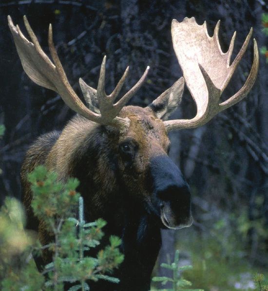
10 | Nopiming Provincial Park

The area around Tulabi Fall Campground was               Nopiming Provincial Park includes significant
identified as a possible location for an ecological      parts of several river corridors in eastern Manitoba.
reserve in 2012 due to the occurrence of several         The Winnipeg, Bird, Black, Rabbit River and
important boreal species of birds including the          Manigotagan rivers are critical for wildlife and provide
Canada warbler which benefit from the mixed woods        high quality opportunities for nature-based recreation.
along the sloped shorelines, the northern parula which   These rivers are currently relatively undeveloped in
makes use of the old man’s beard type moss and the       the park portions (with the exception of the Bird River
bay-breasted warbler which uses the old growth           at Bird Lake) but do see a significant amount of park
conifers in the area. This area was not considered       visitors for fishing, hunting and ecotourism activities;
suitable for an ecological reserve due to the presence   all of which depend on their natural environment.
of the campground and recreational infrastructure all
                                                         As with all of Manitoba, concerns regarding the
ready in place and the location was removed from
                                                         introduction and spread of aquatic invasive species
consideration in 2014. The management of this area
                                                         (AIS) and the potential impact on both the natural
will continue to consider the important habitat it
                                                         environment and water based recreation opportunities
provides for boreal birds and any impacts to these
                                                         are increasing. These concerns are currently managed
species will be considered in future developments.
                                                         through both federal and provincial legislation, and
                                                         by providing information to the public on how to
                                                         “clean, drain, dry and dispose”, to reduce the risk of
                                                         transporting and introducing AIS to new water bodies.
Draft Management Plan | 11
Map 3
Ma
ni g
ot a
Ma nit ob a
Nopiming g an
On tario
R iv
Provincial Park er
Natural Values Map
0 2.5 5 10 Kilometers B la
ck
R iv
er
.
Legend
Highway
Caribou Calving and Re aring Areas
Sensitive Caribou Calving Area
Caribou Occupa ncy Area
Lakes/Rivers
Nopiming/Manig otagan Provinci al Parks
Park Land Use Categories
Backcountry Tulabi
Recreational Develo pmen t
Resource Mana geme nt
r
Provincial Boundary iv e
dR
B ir
Win nipeg Rive r12 | Nopiming Provincial Park
4.1.1 Natural Features: Strategic Objectives 3. Work with the Wildlife and Fisheries branch
and Proposed Guidelines to support initiatives to re-establish and maintain
moose and caribou populations within and near
The following guidelines and objectives will guide the park; this includes the implementation
management decisions in Nopiming Provincial Park of Recovery Strategies and Action Plans.
over the life of the management plan (10 to 1 5 years) New developments (including trails, campsites
regarding the park’s natural features. Should an and portages) should be located to have
activity or development arise that would constitute minimal impact.
a change in land use, have the potential to affect the
natural, geological or cultural values of the park, or 4. Management actions will be communicated
impact the Treaty and Aboriginal rights of Aboriginal with the Eastern Manitoba Caribou Advisory
peoples to pursue traditional uses and activities within Committee and the Moose Management
Nopiming, an appropriate review and consultation Committee; wherever possible, recommendations
process will be designed and implemented. from the committees will be supported.
Objective: To support the Wildlife and Fisheries 5. An updated Sensitive Caribou Calving Area
branch’s efforts in protecting moose and caribou will be used to facilitate the use of the area while
populations, to minimize park visitor impact on protecting caribou habitat during calving (May 1
those populations and to seek possibilities of – July 31). This may include restrictions on
expanding the protected areas of the park to motorists, general activity and shoreline use.
provide additional habitat protection. The area designated and activity restrictions
should be posted at access points, and any
Guidelines: changes should be in place by March 31
1. Pursue rezoning portions of the Resource of each year.
Management LUC to the Backcountry Land Use
6. Work with the provincial wildfire program and
Category in order to provide increased protection.
the Wildlife and Fisheries branch to investigate
This should be centred on the middle block of the
long-term fire management options that reflect
park between the Bird River and Black Lake.
and support wildlife management objectives.
2. Assess opportunities for park expansion along
Objective: To provide additional protection for
the western side of the park. Any new areas will
river corridors within the park.
be established with the purpose of long-term
protection of moose and caribou habitat. Guideline:
7. Within 150 metres of the following river shorelines
(Winnipeg River, Bird River below Bird Lake, Rabbit
River and Manigotagan River), only the following new
recreational infrastructure will be allowed: backcountry
campsites and portages. No expansion of sites that
currently exist will be allowed.Draft Management Plan | 13
Objective: To provide management guidelines Objective: To document and avoid impacts on
for the area that supports the features and species species of special concern.
identified through the former proposed ecological
Guideline:
reserve site at Tulabi Falls.
9. Impacts on known species of conservation concern
Guideline: will be avoided or minimized, and any new
8. Tulabi Falls is an area that has been identified developments or locations will be vetted through
as important to Boreal bird species (including the Manitoba Conservation Data Centre (CDC)
the Canada warbler, northern parula and bay prior to establishment. Any sightings of rare
breasted warbler); in the area around Tulabi species (gathered through the backcountry survey,
Falls Campground, any new campground regular patrols or personal conversations) will be
improvements or developments will minimize tracked and shared with the CDC.
or avoid impacts to these species.14 | Nopiming Provincial Park
4.2 Recreational Use designated winter trails are for snowmobile use. These
trails are part of the provincial SnoMan trail network
Nopiming Provincial Park provides a wide range of and are located in the southern half of the park.
recreational activities including hiking, camping,
fishing, canoeing, kayaking, hunting and Overnight visitors to the park have the choice
snowmobiling. between four provincial campgrounds, one privately
leased campground, designated backcountry sites,
As part of the first round of public engagement for lodges or cottages.
the park management plan in 2014, respondents were
asked what recreational activities they participated in The provincial campgrounds in the park are Tulabi
at Nopiming Provincial Park. The five most indicated Falls (36 sites), Black Lake (80 sites), Beresford Lake (28
responses were: camping, canoeing, fishing, walking sites) and Bird Lake (29 sites). From 2010 to 2014, an
or hiking, and boating. average of 5,140 camper nights were sold in the four
campgrounds combined for nightly camping. All of
Each year traffic counts show some 30,000 vehicles the sites offer basic amenities with a natural setting
entering the park area – roughly 3,000 at the north and only Tulabi Falls offers electrical sites (19 sites).
boundary and 27,000 at the south. This represents Plans are underway for construction of yurt sites at
approximately 105,000 people visiting the park annually. Tulabi Falls. Both Black Lake and Beresford Lake offer
Visitors have the opportunity to enjoy various hiking seasonal sites. The Black Lake seasonal sites have
trails within the park including the Tulabi Falls Trail been completely occupied the last 12 seasons, and
along the Bird River, the nine kilometre Black River the Beresford Lake sites nearly so as well, with an
Trail and two self guiding trails (Walking on Ancient average of 35 seasonal sites being sold from 2010
Mountains and Fire of ‘83). Within the park the only to 2014. For larger groups, Tulabi Falls has one groupDraft Management Plan | 15
Rabbit River to Cole Lake, and Bird River to McGregor
Lake. There are two locations where backcountry
camping is managed through the Parks Reservation
Service: the boat-in sites on Shoe Lake (seven sites
including a designated group use) and the six hike-in
sites at Tulabi Falls Campground.
Several companies offer guided canoe expeditions in
a variety of trip lengths for people who want to
experience the waterways with the help of an outfitter.
Many of the backcountry routes are very popular,
especially the Bird River to McGregor Lake and any
sites that are accessible by motor boat. The frequent
use of these popular routes has led to concerns
about garbage and the overcrowding of popular lakes,
campsites and destination points. Along the Bird
use camping area. Currently, boat launches are
River to Elbow Lake Route there is one private cabin
available at Beresford Lake, Black Lake, and Bird Lake
and one private fish and game club located directly
campgrounds to facilitate fishing and boating for
adjacent to the canoe route. Both of these
campers. There is an unofficial boat launch with no
developments are issued an annual permit.
facilities in the Tulabi Falls Campground on Bird Lake,
and a canoe launch location on Tulabi Lake which There are four private lodges in Nopiming. They are
serves as the starting point for the canoe route. located on the Winnipeg River, Bird Lake, Long Lake
and Quesnel Lake. The lodge located on Bird Lake
The river and lake system throughout Nopiming has
provides a wide range of services for the camping
been a valuable transportation corridor for thousands
and cottage community in the southern portion of
of years. Canoeists today have the opportunity to
the park (including boat rentals and a general store).
follow these routes, and experience a variety of
The Quesnel Lake Lodge lease also includes a
backcountry campsites located along the rivers and
seasonal campground, nightly campground and
lakes. A network of canoe routes through a diverse
backcountry campsites.
landscape offers a variety of canoeing experiences
and links into Ontario’s Woodland Caribou Provincial Organizations which lease areas in the park include
Park and Manitoba’s Atikaki Provincial Park. These a youth camp on Gem Lake and the Department
routes offer a way to enjoy unique areas in the park of National Defence (DND), which has a training site
that many visitors would otherwise not get a chance at Springer Lake. The DND Springer Lake facility
to experience. Currently, most backcountry sites are provides training in a wilderness environment and
available on a first-come, first-served basis, with a few includes simulated exercises. Although these exercises
select locations in the park available by reservation. are generally focused on more remote locations, park
Backcountry camping is only permitted at designated visitors and cottagers sometimes encounter training
sites. First-come, first-served routes with 78 groups along PTH 314 and 315 and near the Bird
backcountry campsites include the Manigotagan River Lake cottage subdivision.
from Long Lake to Quesnel Lake, Beresford Lake to
Garner, Gem or Long Lake the Seagrim’s Lake Chain,16 | Nopiming Provincial Park
Other visitors to Nopiming Provincial Park include Several popular fishing lakes are difficult to access and
those who lease cottage lots. There are approximately over time private boat caches have developed along
450 cottages located within the park. Cottage the shorelines. The practice of caching boats by
subdivisions are located on Bird, Booster, Flanders, individuals facilitates angling in those more remote
Davidson, Beresford and Long Lakes within the park. locations. However it is currently a non-conforming
Some of these subdivisions have ties to the area’s use with The Provincial Parks Act and has often
original mining settlements, while others were resulted in a build up of garbage and other
developed in the 1970s and 1980s. There are also environmental concerns. During the initial round of
a small number of remote cottages scattered public engagement, many respondents indicated
throughout the park, many of which predate park they would like the environmental concerns addressed
designation. Nopiming is unique in that most while still having access to high quality lakes.
cottages are lakefront or lake view, with very
Due to the remote nature of Nopiming Provincial Park,
few back-tier cottages.
off-road vehicle (ORV) use is currently a long-standing,
Nopiming is a popular destination for hunting and non-conforming practice. For many years ORVs have
fishing activities. Nopiming is used by both Manitoba been used to access parts of the park that would be
residents and visitors for hunting, and there are otherwise difficult to get to for angling, mushroom or
several hunting outfitters that operate in the park. berry picking, hunting and other activities that have
In accordance with The Provincial Parks Act, hunting long been a part of the Nopiming landscape. This use
in all provincial parks is prohibited within 300 metres has often occurred along roads and trails that were
of any development (including backcountry campsites). developed through forestry, mining and other
Fishing is one of the main activities for park visitors. resource uses. Due to the rising popularity of ORVs
Walleye, northern pike, trout, tullibee, whitefish and across Manitoba, there are increased concerns for
perch are all common catches by anglers. safety, environmental damage and conflicts between
park visitor’s expectations. Under The Provincial Parks
Act, any trails for motorized vehicles must be
designated. Designated ORV trails within provincial
parks that have management plans are listed as a
Class II development and require an environmental
licence under the Manitoba Environment Act. ORV
use is prohibited on cottage subdivision roads in
accordance with The Off-road Vehicles Act.Draft Management Plan | 17 Map 4
18 | Nopiming Provincial Park

4.2.1 Recreation: Strategic Objectives and 		              12. Damaged backcountry sites may be closed as
		 Proposed Guidelines                                         necessary. Mitigation measures, education and
                                                               enforcement will be used to avoid the creation of
The following guidelines and objectives will guide             new sites. Sites should be assessed on an ongoing
management decisions in Nopiming Provincial Park               basis to identify environmental damage and
over the life of the management plan (10 to 1 5 years)         missing or damaged infrastructure.
regarding the park’s recreational uses. Should an
activity or development arise that would constitute a      13. Designated campsites will be evaluated on
change in land use, have the potential to affect the           an ongoing basis for number and location.
natural, geological or cultural values of the park, or         Any new designation of backcountry campsites
impact the Treaty and Aboriginal rights of Aboriginal          will emphasize the quality of experience and
peoples to pursue traditional uses and activities within       protection of natural features over quantity of
Nopiming, an appropriate review and consultation               campsites. Backcountry campsites, canoe route
process will be designed and implemented.                      and hiking trail designations will take into
                                                               consideration increased visitor impact on natural
Objective: To set backcountry route standards                  features, archaeological sensitivities, wildlife
(including campsite development levels) that                   populations and other users prior to designating.
minimize impact on the landscape and protect the
integrity of the backcountry experience by                 14. Development of a permit system to manage
addressing concern of environmental damage,                    backcountry camping and mitigate concerns
garbage and overcrowding.                                      based on the number of available sites, protecting
                                                               the integrity of the experience (moderate instance
Guidelines:                                                    of encountering people but ability to experience
10. Site inventory information including locations will        solitude), and protecting the landscape will be
    continue to be communicated to help minimize               investigated. If a phased approach is taken to
    impacts and reduce the creation of undesignated            permit system development, then emphasis
    campsites. Route surveys will continue to be               should be placed on locations that have higher
    monitored to assess the number of backcountry              use. When developed, any new system should
    visitors and impacts on the natural environment            accommodate both guided and individual
                                                               recreational opportunities.
11. New developments along designated
    backcountry camping water routes or hike-in            15. Backcountry travel groups with more than
    backcountry locations will be limited to                   nine people will continue to need a special
    infrastructure associated with the backcountry             event permit so that activities can be monitored
    campsites and be appropriate for the route type.           and appropriate sites used for larger groups.
    All designated sites will be equipped with a fire
    pit, picnic table and pit privy or garden throne.
    Bear boxes for storage will be provided at high
    use sites. Portages will be marked and can
    include minor improvements (stairs, minor
    boardwalks, and signage). Conservation of
    natural features will take precedence over
    development of recreational facilities.
Draft Management Plan | 19
Objective: To set development levels (minimum and 18. Black Lake: Maintain the nightly and seasonal
maximum) for each of the four provincial campgrounds. options in a rustic environment. Any upgrades
or expansion to the campground will be done
Guidelines:
with the intent of minimizing impacts on caribou.
16. Bird Lake: Continue to provide sites with a low Walk-in campsites may be investigated, as well
level of development, while assessing a long-term as hiking trail upgrades or opportunities.
plan for the campground which may include
improved site definition, the inclusion of day 19. Beresford Lake: Assess the possibility of some
use facilities or seasonal sites. Investigate the electrification of sites for both nightly and seasonal
possibility of offering electrically serviced sites. options, as well as the ability to provide a remote
check-in for campers. Emphasis should be placed
17. Tulabi Falls: Continue to emphasize a quality on providing an experience for campers who
experience over quantity of sites while providing want a more independent camping option
a variety of camping experiences. Tulabi Falls in a rustic setting.
Campground should serve as the Nopiming
“Entrance to the Wilderness” main service point.
Only nightly options will be provided at Tulabi Falls
Campground. Any facility development should be
linked to the wide range of outdoor recreational
opportunities in the park (fishing, hiking, canoeing,
boating, hunting) and provide opportunities for
both novice and experienced wilderness users.
Campground upgrades may include: additional
yurts or hike-in opportunities, potable water
and modern washroom/shower facilities. The
campground should continue to be a staging
area for the Bird River Canoe Route, offer group
use camping and provide both basic and electrical
service. When possible, opportunities will be
pursued to diversify and improve hiking
opportunities from the campground through
minor trail developments. Any upgrades or
improvements should maintain an emphasis on
the natural environment, maintain the access and
undisturbed view of Tulabi Falls, and protect the
natural shoreline of Tulabi Lake. No motor boat
launch will be provided on Tulabi Lake; boat
launching facilities may be upgraded on Bird Lake.20 | Nopiming Provincial Park
Objective: Establish guidelines on Off-Road Vehicle 22. ORV use may occur to access areas for the
(ORV) use in Nopiming that reflects ORV use as a purpose of licensed angling along marked
long-standing non-conforming practice while identified routes designated in conjunction
addressing the concerns for safety, environmental with Wildlife and Fisheries branch to achieve
damage, impacts on wildlife and conflicts between park and fisheries management objectives.
park users.
23. ORV access may be authorized by annual park
Guidelines: permits for travel to and from remote cottages
20. ORVs are only allowed on trails designated when practical, when the trail and cottage(s) are
expressly for their purpose. Trails may be not located in a Backcountry LUC and when the
designated for year-round or seasonal use, travel does not negatively impact other values in
and should serve as access trails to accommodate area. The permits will only be valid for travel to and
other recreation. Trails may be managed through from the location specified and will not authorize
partnerships or agreements with stakeholder general park travel. These trails are not exclusive
groups. Trails will not be designated in areas and may also be designated for public use under
that are incompatible. This includes but is not the criteria above.
limited to, areas included in the Backcountry 24. Registered trapline (RTL) holders may use an ORV
LUC, along canoe routes, in locations sensitive on their registered trapline for purposes directly
to environmental disturbance and where related to their trapping activities. Possession
wildlife populations may be adversely impacted. of a valid RTL permit is required.
Trail standards will be developed prior to the
establishment, designation and environmental 25. Commercial operators (including outfitters) and
review and assessment under The Environment Act. service providers may be authorized by park
permit to use ORVs for purposes directly related
21. ORV use may occur for licensed hunting purposes to the provision of their operation or service.
under the following conditions:
26. Snowmobile access is allowed on frozen water
i. for access to areas for the purpose of hunting bodies, designated SnoMan Trails, portages and
deer, moose, or bear along marked identified generally used routes. Areas or routes may be
routes designated in conjunction with Wildlife closed by notice or sign to address wildlife
and Fisheries branch to achieve park and concerns, unwanted access, environmental or
wildlife management objectives other concerns. No trail clearing or development
ii. for retrieval of big game by the most direct is allowed except under the authority of a park
route (valid big game hunting licence required) permit for winter access.
iii. under park permits issued by the district to
authorize the use of ORVs for hunting related
purposes including but not limited to the
maintenance of bait stations, and the set up
and take down of hunting camps or tree standsDraft Management Plan | 21
Objective: To mitigate concerns about private boat 29. Boats in a designated cache must be clearly
caches and the associated environmental concerns marked with owner’s name and marked with an
while still providing access to lakes for angling annual sticker (to be picked up at Lac Du Bonnet
and recreation. Office). The number of boats may be limited by
available space, as decided by the district office.
Guidelines:
27. Private boat caches will only be allowed where 30. The following lakes have a long-standing
designated by signs. Any boats that are outside practice of private boat caches:
of designated cache areas are to be posted and Tooth Lake and Gem Lake: Designate a boat
removed as they are found. cache at each lake as an interim measure while
28. Boat caches will not be designated on lakes that investigating and developing a plan for a vehicle
are road accessible, on lakes that have an official access point and boat launch. Once the access
boat launch, where increased motorized traffic point and boat launch is in place, the existing
is a risk to wildlife populations or other natural boat cache will be removed.
features, or in a Backcountry Land Use Category. Flintstone Lake: Remove the current cache
Partnerships may be used to maintain access on Flintstone Lake and promote the lake as a
trails to boat caches. walk-in or portage in (canoe, kayak, light boat)
opportunity. Investigate the need for a small
parking area off the highway.
Birse Lake and Ryerson Lakes: Investigate
the possibility of designating an ORV trail
to access the current boat caches at these
locations. The potential trails will be assessed
for environmental suitability and maintenance
requirements. Signage for trail use and a
staging area will also be developed prior to
designation. Partnership opportunities may
be used for maintenance, trail monitoring and
trail stewardship. No trail will be developed
beyond Birse Lake.
Objective: To provide guidance for any future
boat launch developments that support angling
opportunities in the park.
Guideline:
30. Any new boat launch development will minimize
impacts on other park resources while providing
access to angling opportunities. When possible
boat launches should be located in a way that
allows access year-round.22 | Nopiming Provincial Park
Objective: To guide development and maintenance Objective: To provide guidelines for future
of the non-motorized trail network in the park. development regarding commercial
accommodations.
Guidelines:
31. Short day-use hikes that are already used locally Guidelines:
may be upgraded or considered for official 39. New Lodges or Special Consideration
designation when they start from development Organization facilities are to be only considered
hubs (campgrounds and cottage areas) where in currently developed areas (cottage subdivisions,
parking and staging facilities already exist. campgrounds). Current lodges may be allowed
expansion, however all developments should
32. Investigate trail options that encourage a variety of
provide an atmosphere that is suitable to an
non-motorized uses in multiple seasons (ex: hiking,
outdoor, nature based experience and not duplicate
snowshoeing, cross-country skiing, backcountry
experiences that are already available in the
camping and winter camping).
same area. Any new development or expansion
33. Investigate the possibility of the development of a proposal will only be allowed where there is
multi-day hiking trail that is separate from current sufficient lake development capacity available.
water-routes.
40. Seasonal Campsites on leaseholds are subject
34. Encourage opportunities for user groups to help to the same guidelines as provincially run
in maintaining trails through partnerships and campgrounds. As site holders change, existing
volunteer opportunities. sites are to be brought into compliance by
the leaseholder through direction provided
Objective: To provide guidelines for any future by the district office and the Parks and
cottage development. Protected Spaces branch.
Guidelines: Objective: To provide guidelines for mitigating
35. Any potential expansion of current cottage areas concerns regarding the Springer Lake Facility.
will only occur where available lake development
Guideline:
capacity exists.
41. Work with the Department of National Defence
36. Any potential new cottage areas will have a lake (DND) to mitigate concerns around the
development capacity model done prior to environmental impact of training sessions while
development, avoid backcountry camping or encouraging and facilitating DND to provide
canoeing, avoid high quality caribou habitat and information to the public when training occurs and
only be considered in the south or north portions what visitor’s can expect to encounter.
of the park.
37. No new back tier cottage development.
38. The private cabin located on Elbow Lake, and
private Fish and Game Club on McGregor Lake are
not allowed any expansion or major renovation.
These annual permits should not be reassigned
beyond the original permit holders.Draft Management Plan | 23
4.3 Commercial Resource Use There are multiple mining claims as well as mining
exploration projects currently underway in Nopiming.
There are several different types of commercial Mining activities can occur legally in Resource
resource uses that occur in Nopiming Provincial Park Management and Recreation Development LUCs.
including trapping, wild rice harvesting, hunting and Rehabilitation and remediation of selected orphaned
fishing outfitters and mining. mined sites in Nopiming is ongoing and done under
Nopiming Provincial Park is part of a registered the management of the Mineral Resources branch.
trapline (RTL) area. This means that a person, or Extensive forest harvesting operations occurred in
lineholder, is granted the exclusive opportunity to Nopiming in the past, but stopped in 2009, when
harvest (trap) furbearing animals in a certain area. logging was prohibited. There are many former
There are four RTLs located entirely within the park logging roads still accessible in the park. These roads
and 12 RTLs that straddle the boundary, all of which provide access to remote areas of the park and are
are managed by Wildlife and Fisheries branch for used for recreational activities.
sustainable harvest. There are some cabins
associated with these lines.
There are several lakes in Nopiming with wild rice
leases. Wild rice is not actually rice, but an annual
grass that is harvested either mechanically or by
hand toward the end of the summer or early fall.
Guided hunting and fishing is offered through licensed
outfitters throughout the park. Facilities associated
with outfitting include an outpost on Snowshoe Lake
and several commercial boat caches. Outfitting along
with its associated infrastructure (outcamps,
commercial boat caches, lodges and private
campgrounds) are managed through the
Resource Operators Tourism Licences.
There are commercial boat caches located on
several lakes throughout Nopiming Provincial Park
including Snowshoe, Tulabi, Ryerson, Cat, Shoe,
Gem, Flintstone, Tooth, Happy and Long lake.
These caches are currently managed through an
outfitter’s licence which restricts both the number of
boats and what can be stored with them. Generally,
the commercial boat caches are not associated with
the same garbage and derelict boat concerns as the
privately cached boats.24 | Nopiming Provincial Park
Objective: To provide guidelines for development
of remote commercial facilities, including wild rice
leases, out camps, commercial boat caches, mining
camps, access trails and road developments.
Guidelines:
42. Future Infrastructure applications (outcamps,
commercial boat caches) associated with these
operations may be considered in locations that
do not negatively impact the experience of other
users (ex: no cottage subdivisions or canoe routes)
and where there is sufficient lake development
capacity available.
43. No new infrastructure permits associated with
Wild Rice Licences will be granted. Any new
allocations should use existing access when
4.3.1 Commercial Resource Use: Strategic possible. Any new access should have an emphasis
Objectives and Proposed Guidelines on avoiding or minimizing trail development.
The following guidelines and objectives will guide 44. Work toward an inventory of existing roads and
management decisions in Nopiming Provincial Park trails. Trails that are no longer passable should
over the life of the management plan (10 to 1 5 years) be removed from the list. Any applications to
regarding the park’s commercial resource uses. Should use or reopen those trails that have been
an activity or development arise that would constitute removed from the active list should be
a change in land use, have the potential to affect the treated as new developments.
natural, geological or cultural values of the park, or
Objective: To guide the remediation of quarry
impact the Treaty and Aboriginal rights of Aboriginal
pits within Nopiming Provincial Park.
peoples to pursue traditional uses and activities within
Nopiming, an appropriate review and consultation Guideline:
process will be designed and implemented.
45. Any exhausted quarries should be
remediated as soon as possible.Draft Management Plan | 25
throughout the year. The park has extensive natural
lands where traditional medicines and foods can be
found. This management plan acknowledges and
respects the exercising of Treaty and Aboriginal
rights in the park. Within provincial parks across
Manitoba, off-road vehicles may be used when
hunting, trapping or gathering for food or traditional
ceremonial purposes on lands where there is a
right of access. As well, First Nation people who
are engaged in traditional pursuits of hunting,
fishing or trapping for food, gathering or ceremonial
activities do not require park vehicle permits. Park
vehicle permits are required for access to services
and facility areas and the conducting of commercial
activities (with the exception of wild rice harvesting).
When possible, accommodation for camping is
made available outside of a designated campground
providing there are no issues with safety, conservation,
environmental or other significant concerns.
If concerns about wildlife populations or environmental
damage require additional protections that would
4.4 Cultural Features impact Treaty and Aboriginal Rights, a dedicated
consultation process will be undertaken with
Archaeological research in the vicinity of Nopiming communities prior to any changes.
has provided evidence that various groups of
Indigenous peoples lived in the area for at least 8,000 It was the fur industry that first attracted Europeans
years. One archaeological location produced evidence to the area over 200 years ago, but a larger influx
of a workshop, where tools were fashioned from came with the discovery of gold in 1911. Mineral claims
copper some 4,000 years ago. Some of the cutting were staked in areas that are now part of northern
and scraping tools were made from local white quartz, Nopiming including, the Long, Beresford and Halfway
while some of the other tools found, crafted from Lakes areas. After the 1930s, and towards the end
special rocks, are from more distant places like South of the gold rush, most mining towns in the area were
Dakota and Lake Superior. Since about 1800, most abandoned, and all that was left were remnants of
of the east of Lake Winnipeg was the land of old buildings, abandoned power lines, the tailings
Anishinabe (Saulteux), a branch of the Objibwe and piles of waste rock. Some of this waste rock has
Nation, who migrated westward from Ontario. disappeared, having been used to construct the
Nopiming roadway. Other sites have been reclaimed
The rich cultural values and heritage of Nopiming through Mines and Mineral Branch in recent years.
Provincial Park are commemorated primarily through Visitors to the park may find remnants of long-ago
different historic sites located in the park. Nopiming mining activity in several areas, and can stop to
Provincial Park is used for rights-based activities see the old trapping cabin known as Trapper
by members of several different First Nations. Johnson’s Cabin.
Rights-based hunting and gathering are common
and occur in many areas of the park at different times26 | Nopiming Provincial Park
4.4.1 Cultural Features: Strategic Objective: To provide acknowledgement and
Objectives and Proposed Guidelines guidance for archeological sites within the
park boundaries.
The following guidelines and objectives will guide
management decisions in Nopiming Provincial Guideline:
Park over the life of the management plan (10 to 48. Disturbance of culturally and/or archaeologically
1 5 years) regarding the park’s cultural features. significant sites in the park will be avoided.
Should an activity or development arise that would Information on specific archaeological sites will
constitute a change in land use, have the potential not be made available to the public if there is a
to affect the natural, geological or cultural values significant risk that increased access or visitation
of the park, or impact the Treaty and Aboriginal could pose a threat to the sites. Prior to public
rights of Aboriginal peoples to pursue traditional release of any specific site information, Manitoba
uses and activities within Nopiming, an Conservation and Water Stewardship will confer
appropriate review and consultation process with Historic Resources branch. Where loss of,
will be designed and implemented. or damage to archaeological values due to
natural causes is unavoidable, artifacts will be
Objective: Provide guidance for Trapper
documented and salvaged wherever possible
Johnson’s Cabin and historical mining sites
in co-operation with Historic Resources branch.
that have onsite interpretation.
Guidelines:
46. No conservation efforts will be considered for
historical sites within Nopiming, where possible
staff will document significant changes.
Trapper Johnson’s Cabin will be occasionally
monitored. Restoration work will not be
undertaken at the site.
47. When historic mining sites are rehabilitated,
interpretation will continue to be provided as
to the history of the site. When this information
is updated it will include any modern
rehabilitation efforts. An effort will be made to
continue to display onsite any unique artifacts
that help to tell the history of the site.Draft Management Plan | 27
4.5 Interpretation • to promote the principles of Leave No Trace to
minimize negative human impacts
Providing outdoor educational opportunities and
• work co-operatively with stakeholders and interest
experiences in a natural setting is one of the purposes
groups, aboriginal peoples and other organizations
of provincial parks as stated in The Provincial Parks Act.
to develop partnerships in the development and
A Strategy for Interpretation (Manitoba Conservation
delivery of programs, services and facilities
and Water Stewardship, 2015) outlines the following
specific goals for interpretation in Manitoba’s • to encourage and promote the concept of
provincial parks: environmentally responsible development and
integrated resource management
• to provide a range of thematic programs, based on
• to promote public understanding and support
research and planning, to personally connect the
of the goals, programs and messages of the
visitor to our natural, cultural and historical resources
Department of Conservation and Water Stewardship
• to encourage respect, appreciation and a keener
The interpretive program at Nopiming is comprised
understanding of our park resources
of interpretive signs, two self-guiding hiking trails and
• to help make visits rich and enjoyable experiences an interpretive park map. There is also a display at
for all traveller types Black Lake Campground that highlights Woodland
Caribou in the park.You can also read