STATE HIGHWAY ACCESS MANAGEMENT MANUAL - OHIO DEPARTMENT OF TRANSPORTATION OFFICE OF ROADWAY ENGINEERING
←
→
Page content transcription
If your browser does not render page correctly, please read the page content below

STATE HIGHWAY ACCESS
  MANAGEMENT MANUAL

     OHIO DEPARTMENT OF
      TRANSPORTATION

OFFICE OF ROADWAY ENGINEERING
State Highway Access Management Manual – ODOT Roadway Engineering

Table of Contents
1.0 State Highway Access Management Manual ....................................................................... 1
   1.1 General ................................................................................................................ 1
   1.2 Authority .............................................................................................................. 1
   1.3 Scope of ODOT Access Control Authority ......................................................................... 1
   1.4 Grandfathered Access ............................................................................................... 2
   1.5 Need for Access Management ...................................................................................... 2
2.0 Access Permit Applications and Approval ......................................................................... 3
   2.1 Purpose ................................................................................................................ 3
   2.2 Access Requests ...................................................................................................... 3
   2.3 Permit Application Process ......................................................................................... 4
   2.4 Variances .............................................................................................................. 5
   2.5 Variance Appeal Procedure ......................................................................................... 5
   2.6 Restricting and Removing Access .................................................................................. 5
   2.7 Change of Land Use .................................................................................................. 6
3.0 Access Categories ...................................................................................................... 7
   3.1 Access Requests within LA/RW ..................................................................................... 7
4.0 Driveways ................................................................................................................ 8
   4.1 Normally Allowable Driveway Access.............................................................................. 8
   4.2 Driveway Spacing.................................................................................................... 10
   4.3 Factors that can Affect Driveway Spacing ....................................................................... 11
   4.31 Driveway Overlap .................................................................................................. 11
   4.4 Driveway Proximity to an Intersection ........................................................................... 12
   4.5 Sight Distance ....................................................................................................... 12
   4.6 Driveway Throat Length ............................................................................................ 12
   4.7 Driveway Design ..................................................................................................... 12
   4.8 Driveways Adjacent to Interchange Ramps ...................................................................... 13
5.0 Intersections .......................................................................................................... 14
   5.1 Intersection Spacing ................................................................................................ 14
   5.2 Intersection Considerations ........................................................................................ 14
6.0 Traffic Signals ......................................................................................................... 15
7.0 Traffic Analysis and Traffic Volumes ............................................................................. 16
   7.1 Traffic Analysis (TA) ................................................................................................ 16
   7.2 Traffic Analysis Volumes ........................................................................................... 16
8.0 Turn Lane Warrants .................................................................................................. 19
9.0 Traffic Impact Study (TIS)........................................................................................... 20

                                                               i
State Highway Access Management Manual – ODOT Roadway Engineering

   9.1 When is a Traffic Impact Study needed? ......................................................................... 20
   9.2 What is the Purpose of a Traffic Impact Study? ................................................................ 20
   9.3 Traffic Impact Study Review Process ............................................................................. 20
   9.4 Traffic Impact Study Requirements .............................................................................. 22
10.0 Permit Issuance and Terms of Approval ........................................................................ 24
   10.1 Permit Issuance .................................................................................................... 24
   10.2 General Provisions Applying to All Access Permits ............................................................ 24
   10.3 Construction and Compliance with Access Permits ........................................................... 24
Appendix A - ODOT District Contacts .................................................................................. 26
Appendix B – Traffic Count Restrictions .............................................................................. 27
Appendix C – References and Resources .............................................................................. 28
Appendix D - Definitions and Abbreviations ......................................................................... 29

                                                              ii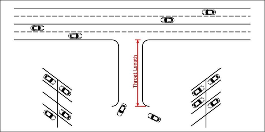
State Highway Access Management Manual – ODOT Roadway Engineering

ODOOT’s Mission and Vision                       ODOT’s Guiding Principles

                                     iii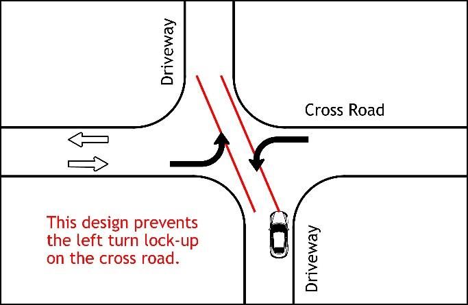
State Highway Access Management Manual – ODOT Roadway Engineering

1.0 State Highway Access Management Manual                                                REVISION DATE
                                                                                            July 2018
1.1 General
The State Highway Access Management Manual establishes procedures and standards to protect the utility,
function, capacity, and safety of the state highway system. The state highway system constitutes an
integrated network of highways interconnecting all areas of the state and serving the safe, efficient
movement of people and goods. The state highway system represents an irreplaceable public asset essential
to the public health, safety, and welfare. The Ohio Department of Transportation has an obligation and a
public-trust responsibility to preserve and maintain this system, to protect the public investment in this
system, and to ensure its continued use in meeting state, regional, and local transportation needs.

It is a goal of the Department to preserve and manage the state highway system more effectively. It is a
goal of the Department to improve public safety in the development, design, and operation of the state
highway system. It is a goal of the Department to maintain and protect the state highway system's function
and ability to move people and goods efficiently and conveniently.

The Department is committed to implementing access management policies and sound engineering
standards that reduce highway congestion, minimize traffic delay, improve traffic flow, preserve highway
capacity, and reduce crashes while balancing the need for access and supporting development. The
Department is further committed to preventing to the extent practical any conditions from occurring in the
development, design, and operation of a highway that cause or contribute to a decline in the highways
designed and intended traffic function and that require excessive expenditure of public funds to correct.

To accomplish its goals and meet its obligations, the Department has developed this State Highway Access
Management Manual to manage access to state highways as necessary to protect the public health, safety,
and welfare; to preserve the operational and functional integrity of the state highway system; and to
promote the safe and efficient movement of people and goods.

Except in cases of purchase or appropriation of access rights, nothing in this Manual shall deny the property
owner the right to reasonable access to the general, public street system. However, the access rights of a
property owner are subject to regulation for the public health, safety, and welfare and are subordinate to
the public's rights and interests in a safe, efficient highway. The right of an owner of property to access to a
state highway or to a particular means of access may be restricted if reasonable, alternative access is
available or can be obtained to the general, public street system.

1.2 Authority
The State Highway Access Management Manual authority is derived from powers conferred on the Director of
the Department of Transportation by Section 5501.31 and Section 5515.01 of Ohio Revised Code (ORC).

1.3 Scope of ODOT Access Control Authority
ODOT is responsible for the control of access on the following roads:

   a. All Interstate facilities;
   b. All State and U.S. Routes where the Right-of-Way (R/W) was purchased as Limited Access (LA/RW)
      including along an interchange cross street;
   c. State and U.S. Routes outside of incorporated areas
Control of access for all other roadways is the responsibility of the local maintaining agency (City, County,
Village or Township)

                                                       1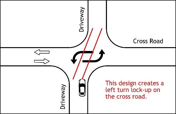
State Highway Access Management Manual – ODOT Roadway Engineering

1.4 Grandfathered Access
As of September 1, 1998, all vehicular access and connections to the state highway system were regulated in
accordance with the provisions of the State Highway Access Management Manual.

All access connections providing vehicular movement to or from a state highway, and in use prior to
September 1, 1998 or constructed in accordance with a valid permit issued by an appropriate local authority
having jurisdiction over the highway at the time of issuance of the permit shall be considered access
connections exempt from the policies, requirements, criteria, and standards of the State Highway Access
Management Manual until or unless the use of the property changes making the access subject to provisions
in Section 2.7.

1.5 Need for Access Management
Access Management is the practice of controlling the number, type, size, and location of access points to
the roadway system in order to promote the efficient and safe movement of traffic. FHWA cites access
management as a proven safety countermeasure (https://safety.fhwa.dot.gov/provencountermeasures/).

                                                     2
State Highway Access Management Manual – ODOT Roadway Engineering
2.0 Access Permit Applications and Approval
2.1 Purpose
This section sets forth the procedures and requirements governing the issuance and approval of access
permits for use or occupancy of right-of-way on state highways.
2.2 Access Requests
Ohio’s 88 counties are divided between twelve ODOT Districts. Requests for an access permit should be
directed to the District based on the county location of the proposed access. Refer to Appendix A for a map
showing which ODOT district has authority for which county. Appendix A also provides contact information
for each district. Requests related to an access should be directed to the District Permit Coordinator (DPC).
The DPC will provide information regarding submission requirements based upon the location, the land use
and traffic the proposed access point(s) will service. A Traffic Analysis is required for any development that
adds 60-200 trips (in and out) and a Traffic Impact Study is required for any development that adds over 200
trips (in and out). For proposed access points that generating more than 60 Trips (entering and leaving) in an
hour; the applicant should request a preliminary meeting with ODOT to discuss the proposed development
prior to making a formal access request. This will help ensure that all of the required information is
submitted with the subsequent application.
For reference, Table 2-1 illustrates some possible developments that may generate 60 and 200 trips (based
on ITE Trip Generation Manual 9th Edition):
Table 2-1
3State Highway Access Management Manual – ODOT Roadway Engineering
At the preliminary meeting applicants should present sufficient materials such as aerial maps, site plans,
and documents to illustrate the site, the size and type of proposed land use, estimated traffic volumes and
vehicle types generated by the site, adjacent public roads and highways, and any existing or available
alternative access points. A map showing the proposed study limits for review and acceptance should be
provided. This information should be provided to ODOT prior to the preliminary meeting to allow time for
review and consideration.
With this information ODOT can examine the feasibility of the access proposal with the applicant and
consider whether it is permissible under the Department's access standards. ODOT will decide whether a TA
or TIS is warranted, and if so, define its scope. ODOT reserves the right to require a TA or TIS for any
proposed access without regard to the land use or trips that would utilize the proposed access. Preliminary
discussion can expedite later review and evaluation of the permit application. Comments, suggestions, and
recommendations made during any preliminary meeting are in no way binding upon the Department in
subsequent evaluation of a formal permit application or decisions about the issuance of a permit.
2.3 Permit Application Process
An access permit application (MR 505) should be submitted to the District Permit Coordinator (DPC) who will
coordinate internally with ODOT as necessary (County Manager, District Variance Committee, Office of
Roadway Engineering, C.O. Appeals Committee etc.). The DPC may delegate the request within the district
as necessary; however, it is the responsibility of the DPC to monitor the request for a timely response and
completion by the Department. An access request may be submitted via mail or electronically via email.
Decisions for an access request will generally be provided within 30 calendar days after all necessary
application information is provided and correct.
For requests that are not a variance, the DPC will normally approve the request, however, specific
requirements may be assigned to the approval (ex. location, access type, movement restrictions, etc.).
Figure 2-1 - Permit Review Process
4State Highway Access Management Manual – ODOT Roadway Engineering
2.4 Variances
An access variance grants permission to depart from the standards and requirements of the State Highway
Access Management Manual. Variance requests should specify in writing what standards cannot be met and
why in order to document and support the request.
In the case of a variance request, the DPC (or delegated designee) may:
a. Contact the applicant to discuss why the variance is being requested in lieu of meeting the normally
allowable access provisions. The DPC may suggest changes to the applicant that will make the
requested access no longer a variance or make the proposed access more closely meet the normally
allowable access requirements. Changes to the application resulting from discussions with the
applicant should be documented, potentially requiring a revised submission at the discretion of the
DPC depending on the complexity of the changes. Alternatively, the DPC may revise the submitted
application per discussion and agreement with the applicant; or
b. Make a recommendation to the District Variance Committee who will render a variance decision; or
c. Issue a variance decision if that authority has been delegated to the DPC from the District Variance
Committee.
Approvals of a variance that provides direct access to a Category 1 facility will require the concurrence of
the Office of Roadway Engineering (ORE). This shall also include access requests that affect LA/RW along an
interchange cross street. The DPC will coordinate with ORE; ORE will coordinate with the Federal Highway
Administration (FHWA) as necessary.
ODOT or Local authorities may establish an ODOT approved access management plan for a State Highway
System corridor or section of corridor. Access requests that differ from an approved access management
plan are not necessarily considered variances. Contact the District Permit Coordinator for information
regarding access management plans.
2.5 Variance Appeal Procedure
When an applicant objects to the denial of a variance request, the applicant may file an appeal with the
DPC. The DPC will coordinate with ORE and the C.O. Appeals Committee. The appeal submission needs to
include reasons for the appeal and may include changes, revisions, or conditions that would be acceptable
to the applicant. The C.O. Appeals Committee will provide a decision within 45 days. If the variance request
is denied the applicant may submit a permit application and plans reflecting the decision.
2.6 Restricting and Removing Access
Owners of property abutting on a public highway possess not only the right to the use of the highway in
common with other members of the public, but also a private right or easement for the purpose of ingress
and egress to and from the abutting property, which right may not be taken away or destroyed or
substantially impaired without compensation. Even so, the State may modify or restrict a property owner’s
access without compensation as long as there is no denial or substantial interference with ingress and
egress.
The exercise of this discretion to reasonably regulate access to and from the public roadway does not
require that
a. access be provided to the State Highway System if reasonable access is available via the local
street system; or
b. a full movement access be provided; or
c. multiple access points be provided
5State Highway Access Management Manual – ODOT Roadway Engineering
ODOT has the responsibility to preserve and maintain the State Highway System, to protect the public
investment in this system, and to ensure its continued use in meeting state, regional, and local
transportation needs. This responsibility, however, can sometimes require ODOT to control access in a
manner that restricts what a property owner proposes for access. In these cases ODOT may deny or restrict
access to the State Highway System. In cases where existing access is restricted or denial of direct access to
the State Highway System is considered, the DPC should consult with the District Real Estate Administrator
concerning implications of the property rights of an abutting owner; or assistance should be requested from
the Office of Chief Legal Counsel.
When access management standards are considered in designing of a highway improvement project, the
District Real Estate Administrator should be consulted for implications of the rights of access and exercise of
discretion to reasonably regulate access, or assistance sought from the Office of Chief Legal Counsel.
2.7 Change of Land Use
The property owner or permittee, if applicable, may be required to reconstruct, relocate, redesign, remove
or otherwise modify an existing access in order to conform to the standards and design specifications of the
State Highway Access Management Manual or L&D Manual Volume 1 when a change in use of the property
results in a change in the type or nature of access operation. A change in use may include, but is not limited
to, structural modifications, remodeling, a change in the type of business conducted, expansion of an
existing business, a change in zoning, or a division of property creating new parcels, but does not include
modifications in advertising, landscaping, general maintenance, or aesthetics which do not affect traffic
operations and safety. Previously approved accesses for properties that have been vacant for 2 years or
more will not be grandfathered as an approved access point.
Change in use includes but is not limited to the following:
The use of the access increases in actual vehicular volume by 20 percent or more or an actual
increase of 10 or more trips in the peak hour;
The traffic volume of a particular directional characteristic (such as left turns) increases by 20
percent or more or an actual increase of 5 or more trips in the peak hour;
The use of the access by vehicles exceeding 30,000 pounds gross vehicle weight increases by 20
percent or more or an actual increase of 10 or more trips in the peak hour;
The use of the access increases in actual vehicular volume from a level not exceeding Manual
warrants and standards for design elements, to a level exceeding Manual design warrants and
standards by 20 percent or more;
The historical use of the access was less than daily use, and the new use would be for daily use of
the access;
The free flow of vehicles entering the property is restricted causing vehicles to queue on the
highway, creating a highway hazard.
6State Highway Access Management Manual – ODOT Roadway Engineering
3.0 Access Categories
The Department assigns an “access category” to each section of roadway where ODOT has the responsibility
to control access. The access category assigned to a road in conjunction with the number of vehicles (Trips
in/out) using a proposed access determines the normally acceptable number, location and types of accesses
that can be permitted for that roadway.
Applicants can determine the access category of a route by contacting the DPC or checking the Access
Category website (https://gis3.dot.state.oh.us/DistrictAccessManagement/). Applicants should always
confirm with the DPC that the map is correct. With the access category identified and the number of Trips
established, the normally allowable accesses and restrictions can be determined.
The following describes the three different types of access categories:
Category 1
Freeway and expressway facilities with Limited Access Right-of-Way (LA/RW) including the cross street
LA/RW adjacent to an interchange ramp. Freeways are divided multi-lane highways for through traffic with
all crossroads separated in grade with full access control. Freeways include all Interstate and Interstate
look-alike facilities. No private driveway or at grade intersection access is permitted on freeways.
Expressways primarily serve interstate, interregional and intercity trips and may have both interchanges and
at-grade intersections. No private driveway access is permitted on expressways unless the property owner
retains deeded rights and has no other reasonable access to the general public street system.
Category 2
State and U.S. routes with a higher level of access control due to factors such as: existing drive density,
congestion, crash issues, existing or potential for major development, etc. These are typically urban and
suburban facilities that may or may not involve LA/RW. Private driveway and intersection access is
potentially permissible.
Category 3
All other State and U.S. routes under ODOT’s jurisdiction not assigned to one of the above access categories.
These are typically rural and possibly suburban facilities with little existing or expected potential for major
development and minimal crash or congestion issues. These facilities may or may not involve LA/RW. Private
driveway and intersection access is potentially permissible.
3.1 Access Requests within LA/RW
Any access requests within the limits of existing LA/RW or change of an existing deeded access will require
consideration through the District Real Estate Administrator under Section 7306 of the ODOT Real Estate
Manual since it requires either conveyance of necessary access rights or release of highway easement (both
being considered to be property disposal) in addition to an access permit. This process also involves
determination of enhanced value as provided in Section 4501.02 of the Real Estate Manual. The District Real
Estate Administrator must be consulted prior to processing any request for permit which involves a new or
revised opening in LA/RW. Additional assistance can be requested from the Office of Chief Legal Counsel.
Information related to locked-gate access to freeways and other limited access highways is provided in
Section 801.2.6 of the L&D Manual Volume 1.
7State Highway Access Management Manual – ODOT Roadway Engineering
4.0 Driveways
4.1 Normally Allowable Driveway Access
Driveways are defined in Appendix D. Private driveway access is normally only permissible on Category 2
and Category 3 facilities. Table 4-1 provides submission requirements and guidance governing what is
normally allowed for driveway access requests on these facilities.
Table 4-1
(A) Number of Trips (Peak Hour)
The number of vehicle Trips entering/exiting a proposed driveway access in the peak hour can be
determined in several ways depending on the situation:
a. A proposed access serving a new land use typically requires a Trip calculation to be made.
This methodology is defined by the Institute of Transportation Engineers (ITE) and is published
in the ITE Trip Generation Manuals. Where a proposed access will service a land use not
included in the Trip Generation Manual, the applicant should consult with the DPC for
guidance.
b. With the concurrence of the DPC; Trips for the same land use at another very similar existing
location may be used.
c. Minimal use drives serving things such as a single tenant private residence, utilities,
agricultural fields, etc. need only note in the MR505 the number of trips being “State Highway Access Management Manual – ODOT Roadway Engineering
d. The DPC has the authority to decide the best methodology to determine the number of Trips.
Applicants of an access permit should consult with the DPC if unsure of the methodology to
determine the Trips.
(B) Submission Requirements
In addition to the submission requirements outlined in Table 4-1, access requests may also include
supplementary visual information such as maps, deeds, bonds, site plans, cost estimates,
construction plans, drawings on an aerial image, diagrams or other similar exhibits showing the
location of the proposed access and its relation to adjacent access points within 1000 feet (including
if the nearest adjacent access point(s) is on a different property). The extent of this supplementary
information should be commensurate with the complexity of the access request.
a. MR505 – This is the standard access request form that can be found at
http://www.dot.state.oh.us/districts/D11/Documents/MR505.pdf. A MR505 is required with
every access request.
b. Traffic Analysis (TA) – The TA serves two purposes:
i. Determines the need for left/right turn lanes. See Section 7.0 for information on a
Traffic Analysis and Section 8.0 for information on turn lanes; and
ii. Determines the number of lanes required on the state highway or driveway through
the analysis of the proposed drive using the latest version of the Highway Capacity
Software. Every movement should be LOS D or better in the design horizon year.
c. Traffic Impact Studies (TIS) – Comprehensive analysis of potential access impacts. TIS
guidance is provided in Section 9.0.
d. Sight Distance Study - Based on the topography adjacent to the proposed access, a sight
distance study may be required. See Figures 201-4E and 201-5E in the L&D Manual Vol. 1.
e. Maintenance of Traffic Plan – Access Permits involving construction that encroaches on the
roadway or shoulders shall include a Maintenance of Traffic Plan in accordance with the
OMUTCD.
(C) Permitted
Where a parcel otherwise has reasonable access to a local street system, ODOT has the discretion to
deny a request for additional direct access to/from the State or U.S. Highway system. No additional
access will be provided for the splitting or dividing of existing parcels currently under common
ownership or control. All access to such newly created properties from property splits should be
provided internally from the existing access.
(D) Traffic Movement
Table 4-1 provides the normally allowable movement types for each access category. ODOT reserves
the exclusive right to determine the type and number of access points to the State Highway System.
a. Category 2 Facilities
i. One direct private access will be permitted per parcel or contiguous parcels under
common ownership. Additional accesses would require a variance. No direct private
access will normally be permitted if the property has other reasonable access or
opportunity to obtain such access from the local street network. If allowed, the access
will generally be restricted to right-in/right-out. Left turn movements may be
permitted based upon the following considerations:
1. The left turn does not have potential for signalization;
2. ODOT concurs that the left turn movement will not cause congestion or a
safety issue;
3. The left turn does not interfere with operation of the adjacent street and
properties
9State Highway Access Management Manual – ODOT Roadway Engineering
ii. Driveway access requests on facilities with an existing median will be restricted to
right-in/right-out unless ODOT concurs that a left turn movement from the proposed
driveway provides an operational or safety benefit to the general public. This also
applies to minimum use drives.
iii. Left turn movements out of a proposed driveway will not be allowed onto multi-lane
roadways where the turning vehicle must cross 3 or more lanes of through traffic
(includes positive left turn lanes but not a two-way left turn lane).
b. Category 3 Facilities
i. One direct private access will be permitted per parcel or contiguous parcels under
common ownership. Additional access may be permitted without a variance if ODOT
concurs that an additional access:
1. Would not adversely affect the safety and operation of the highway, and
2. Is necessary for the safe or efficient use of the property, and
3. Would not adversely affect adjacent properties.
ii. Driveway access requests on facilities with an existing median will be restricted to
right-in/right-out unless ODOT concurs that a left turn movement from the proposed
driveway provides an operational or safety benefit to the general public. This also
applies to minimal use drives.
It is recognized that some properties may require additional access points than is normally allowed in order
to function properly; usually due to the type of land use occupying the property. In these cases
consideration of a variance can be given to allow additional access points. Additional access points should
be evaluated to determine if a restricted movement would, in the opinion of ODOT, provide sufficient
additional access. For corner properties, it is recommended that the main access point be located on the
side street whenever possible.
4.2 Driveway Spacing
Table 4-2 provides minimum driveway spacing requirements. In general, it is desirable to provide the
maximum spacing possible while providing adequate sight distance. The table below represents the
minimum spacing that can be provided without the request being a variance.
Table 4-2
*Use recommended distance unless a documented reason is provided and agreed to by ODOT. Approved driveways
meeting or exceeding the minimum spacing do not require a variance.
10State Highway Access Management Manual – ODOT Roadway Engineering
4.3 Factors that can Affect Driveway Spacing
Table 4-2 provides normally allowable driveway spacing dimensions. There are factors, however, that should
be considered when choosing a driveway location including but not limited to:
a. Driveway Overlap
b. Driveway Proximity to an Intersection
c. Sight Distance
The driveway spacing distances provided in the Table 4-2 may potentially be altered as necessary to address
these and other factors specific to an access request.
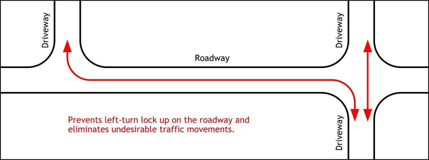
4.31 Driveway Overlap
Driveways located on opposite sides of the street, especially medium and high volume drives, should avoid
having overlapping left turn entrances whenever practical. Figure 4-1 through Figure 4-3 provides
information related to driveway overlap.
Figure 4-1 Figure 4-2
Figure 4-3 – Most Preferred
11State Highway Access Management Manual – ODOT Roadway Engineering
4.4 Driveway Proximity to an Intersection
Driveways located too close to intersections can cause operational and/or safety problems. Table 4-2 should
be used to determine the appropriate corner clearance distance. In most cases driveways near intersections
shouldn’t allow full movements in/out if those movements are required to cross left turn lanes serving the
intersection on the adjacent primary street. Driveways should not be permitted within the boundaries of a
turn lane, but if there is no other option, consideration should be given to limiting the drive to right-in/right-
out or right-in only. It may also be desirable to locate a drive as far as possible from the intersection; even
though this would result in the proposed drive being located closer to the drive on the adjacent property.
4.5 Sight Distance
Driveway spacing may need to be varied from Table 4-2 in order to provide, improve or maximize sight
distance. The recommended sight distance is Intersection Sight Distance (ISD) with the minimum being
mainline Stopping Sight Distance (SSD). Refer to Section 201 of the L&D Manual Volume 1 for Sight Distance
guidance.
4.6 Driveway Throat Length
Care should be taken to ensure proposed drives, especially to large traffic generators such as malls and
shopping centers, provides sufficient driveway throat length to ensure that vehicles entering a parking
facility do not backup (queue) into the public street system. Generally, entering movements should free-
flow into the parking area that do not need to yield or stop for vehicles exiting or traversing through the
parking area.
Figure 4-4
For exiting vehicles, sufficient throat length should be provided to store the expected/calculated queue of
exiting vehicles (Figure 4-4). Refer to Figure 803-9 in L&D Manual Volume 1 for relevant design information.
4.7 Driveway Design
Driveway design standards are provided in Section 803 of the L&D Manual Volume 1 and Standard Construction
Drawing BP-4.1.
12State Highway Access Management Manual – ODOT Roadway Engineering
4.8 Driveways Adjacent to Interchange Ramps
Driveways and intersections are not permitted within the interchange LA/RW along the adjacent cross-street
per L&D Manual Volume 1, Section 801.2.5. However, in rare cases when this must be contemplated, sufficient
analysis using a 20 year design is required to ensure there would be no detrimental operational effects on the
interchange. Drives or intersections adjacent to a ramp must be analyzed with HCS and may be required to
supplement with simulation. The study limits must include all ramp intersections. A TIS may be required to
assess impacts of the proposed access, especially for an access request within 1000’ of an interchange ramp
terminal.
Lane use changes within the interchange area necessitated by an access request will require an approved
Interchange Study (IOS, IMS, or IJS) as applicable prior to an access request being approved. Refer to Section
550 of L&D Manual Volume 1 for information related to an IOS, IMS, or IJS.
13State Highway Access Management Manual – ODOT Roadway Engineering
5.0 Intersections
It is recognized that there may be limited opportunity to dictate the precise location of a proposed
intersection. The below provides guidance related to recommended intersection spacing where the
opportunity to control the spacing is available. In cases where intersection location cannot practically be
provided, spacing should be maximized to the extent possible.
5.1 Intersection Spacing
Intersections are defined in Appendix D. For intersection spacing refer to Table 5-1.
Table 5-1
*See L&D Vol. 1 Section 550 for information related to interchange spacing requirements
5.2 Intersection Considerations
Intersections should be located to provide required sight distance (Refer to Section 201 of the L&D Manual
Volume 1) and meet geometric design criteria (Refer to Section 400 of L&D Volume 1). Traffic Analysis or a
TIS is required to determine the number of lanes on each approach. If an intersection is proposed to be
signalized, or if it is likely in the future, refer to Table 5-1 to determine the appropriate intersection spacing.
Approval of proposed intersections that do not meet Table 5-1 spacing requirements must be processed as a
variance. It is generally desirable to minimize the number of intersections to the extent possible while
balancing the need for access. Existing reasonable access to the local street network should be considered
prior to approving a new intersection on the State Highway System.
Intersections must comply with ADA requirements.
In cases of an access request resulting from a development created street that will become a public street;
the application shall include a signed letter from the County or Municipal Engineer (as applicable) indicating
approval of the developer’s road or street plan.
14State Highway Access Management Manual – ODOT Roadway Engineering
6.0 Traffic Signals
Any traffic signals requested or required as part of an access request shall be justified using the warrants
established in Part 4 of the Ohio Manual of Uniform Traffic Control Devices (OMUTCD). Documentation of
meeting a traffic signal warrant shall be included with any access requests that include a traffic signal.
It should be noted that, per Section 4C.01 of the Ohio Manual of Uniform Traffic Control Devices, meeting a
signal warrant does not imply that ODOT or any maintaining agency must install a traffic signal. The decision
to approve a signal installation should be dependent on several factors including but not limited to safety,
proximity to and coordination with adjacent signals and storage requirements. See Section 5.1 for
recommended and minimum intersection spacing.
In addition, traffic signals installed to serve private access points require a signal maintenance agreement
assigning annual operation and maintenance cost for the traffic signal. Refer to the ODOT Traffic Engineering
Manual (TEM) Section 401-7 for specifics related to traffic signal maintenance agreements and the associated
costs.
15State Highway Access Management Manual – ODOT Roadway Engineering
7.0 Traffic Analysis and Traffic Volumes
7.1 Traffic Analysis (TA)
See Table 4-1 to determine when a Traffic Analysis is required.
A Traffic Analysis may be required for any proposed access within a location identified by ODOT’s Highway
Safety Program as a safety problem area or crash location or any location identified by ODOT as a congested
traffic area even if the trip threshold is not met.
7.11 Purpose
The TA serves two purposes:
a. Determines the need for left/right turn lanes. See Section 8.0 for information on turn lanes; and
b. Determines the number of lanes required on the state highway or driveway through the analysis of
the proposed drive using the latest version of the Highway Capacity Software. Every movement
should be LOS D or better in the design year.
7.12 Submission Requirements
The Traffic Analysis should include a Capacity Analysis, Turn Lane Warrants, and Turn Lane Storage
calculations.
7.13 Capacity Analysis
HCS is required and Synchro maybe requested by the District if necessary. Each software is required to be
used in accordance with ODOT’s requirements as stated in L&D Vol. 1 Section 401.2.
7.14 Study Limits
At a minimum the study limits need to include all proposed or modified access points and their adjacent
intersections. If determined necessary by the District, additional analysis points may be requested.
7.15 Design Year
The Design Year is Opening Year + 10 years. Typically, the weekday AM peak and PM peak hour traffic
volumes are required however, there are cases where the weekday or weekend midday peak hours may also
be required.
7.2 Traffic Analysis Volumes
The following methodologies may be utilized to determine the volumes used for the purposes of a Traffic
Analysis (Turn Lane Warrant and Capacity Analysis). A Traffic Analysis is required for proposed access points
serving 60-200 trips. These methods are not to be used for other ODOT design traffic procedures. Refer to
Section 9.0 for information related to TIS design volumes. A full TIS may be conducted in lieu of these
procedures if desired.
The AM and PM peak hours of the adjacent street will be used in a Traffic Analysis. Based on the land use,
alternative hours such as the midday peak (11a-1p) or weekends may be more appropriate for the Traffic
Analysis. The DPC should be consulted regarding the necessary analysis hours. The analysis hours would
normally be discussed as part of the scope for the study.
If SHIFT or TIMS data is not available refer to Chapter 4 (Section 4.2.1) in the Ohio Traffic Forecasting Manual
Vol. 1 for other methods for obtaining a background traffic growth rate.
7.21 Hourly Count Method 1
a. Counts - Count adjacent street AM & PM Peak hour traffic using the 4 highest consecutive 15 minute
intervals per Appendix B. The hours/days may vary based on land use.
b. Design Year - Apply growth factor to adjacent street traffic counts using a 10 year analysis horizon.
Growth factor (rate) can be obtained using the ODOT SHIFT Tool (preferred) or from the ODOT
16State Highway Access Management Manual – ODOT Roadway Engineering
Transportation Information Management System (TIMS). TIMS is available on the ODOT Office of
Technical Services web site. (https://gis.dot.state.oh.us/tims). Growth rates are not compounding.
Example – 1.5% growth per year x 10 years = 1.15 multiplier for adjacent street counts;
c. Design Hour Traffic - Convert 10 year adjacent street hourly traffic from (b) to a design hour count
by multiplying each count by 1.2.
d. Overlay Trips - Overlay the number of trips using the proposed access. Proposed pass-by trips should
be in accordance with the ITE Trip Generation Manual. The Trip volumes should correlate to the
adjacent street peak hour (i.e., the corresponding AM or PM “Peak Hour of Adjacent Street” from the
ITE Manual). In the absence of better information, directional distribution percentages of the access
Trips can match the directional distribution of the adjacent street;
e. Utilize the traffic volumes from (d) for the purposes of Turn Lane Warrant Analysis and Capacity
Analysis for both of the peak hours.
7.22 Hourly Count Method 2
a. Counts - ODOT maintains an inventory of traffic counts in the MS2 online system. MS2 is available at
(http://odot.ms2soft.com/tcds/tsearch.asp?loc=Odot&mod=). Existing counts in the MS2 system
located in the vicinity of the proposed access may be used with the permission of the DPC in lieu of
performing new counts.
b. Design Year - Apply growth factor to adjacent street traffic counts using a 10 year analysis horizon.
Growth factor (rate) can be obtained using the ODOT SHIFT Tool (preferred) or from the ODOT
Transportation Information Management System (TIMS). TIMS is available on the ODOT Office of
Technical Services web site.
(https://www.dot.state.oh.us/Divisions/Planning/TechServ/Pages/tims.aspx). Growth rates are not
compounding. Example – 1.5% growth per year x 10 years = 1.15 multiplier for adjacent street
counts;
c. Design Hour Traffic - Convert 10 year adjacent street hourly traffic from (b) to a design hour count
by multiplying each count by 1.2.
d. Overlay Trips - Overlay the number of trips using the proposed access. Proposed pass-by trips should
be in accordance with the ITE Trip Generation Manual. The Trip volumes should correlate to the
adjacent street peak hour (i.e., the corresponding AM or PM “Peak Hour of Adjacent Street” from the
ITE Manual). In the absence of better information, directional distribution percentages of the access
Trips can match the directional distribution of the adjacent street;
e. Utilize the traffic volumes from (d) for the purposes of Turn Lane Warrant Analysis and Capacity
Analysis for both of the peak hours.
7.23 AADT Method
a. AADT - Obtain a nearby AADT from ODOT’s MS2 system;
b. Factor AADT - Apply K and D factors to the 2-way AADT. K=0.1 and D=0.55 may be used in the
absence of more specific values being available to obtain the design hourly volume. Where 1-way
AADT is provided by MS2 the D Factor is not required and each directional AADT can apply the K
factor separately, note that K factors listed in MS2 should generally NOT be used as these are not K30
design hour factors unless the site is a permanent counting station;
c. Design Year - Apply growth factor to adjacent street traffic counts using a 10 year analysis horizon.
Growth factor (rate) can be obtained using the ODOT SHIFT Tool (preferred) or from the ODOT
Transportation Information Management System (TIMS). TIMS is available on the ODOT Office of
Technical Services web site.
(https://www.dot.state.oh.us/Divisions/Planning/TechServ/Pages/tims.aspx). Growth rates are not
compounding. Example – 1.5% growth per year x 10 years = 1.15 multiplier for adjacent street
counts;
d. Overlay Trips - Overlay the number of trips using the proposed access. Proposed pass-by trips should
be in accordance with the ITE Trip Generation Manual. The Trip volumes should correlate to the
adjacent street peak hour (i.e., the corresponding AM or PM “Peak Hour of Adjacent Street” from the
ITE Manual). In the absence of better information, directional distribution percentages of the access
Trips can match the directional distribution of the adjacent street;
17State Highway Access Management Manual – ODOT Roadway Engineering
e. Utilize the traffic volumes from (d) for the purposes of Turn Lane Warrant Analysis and Capacity
Analysis.
f. The application of K and D Factors to a 2-way AADT are normally only used to produce the highest
peak hour for one direction in the 30th highest hour. In order to perform Traffic Analysis for both AM
and PM peak hours by factoring a 2-way AADT, use the same K and D Factor for both the AM and PM
peaks while overlaying the appropriate AM and PM Trip Generation numbers. Document assumptions
for applying the D factor in the AM & PM peak hours (which direction is the peak). This is a very
conservative approach that should not normally be used. It is preferred to use an hourly count
method or use directional AADT’s if available.
18State Highway Access Management Manual – ODOT Roadway Engineering
8.0 Turn Lane Warrants
At unsignalized access points turn lane warrant analyses must be performed to determine if right or left turn
lanes are warranted.
Table 4-1 denotes turn lanes as being “N/A” for low volume and minimal use drives. Turn lanes for these
drives, however, may be required for considerations such as:
1. Providing acceptable levels of service as determined by the Traffic Analysis or TIS; or
2. Mitigating existing or expected crash concerns; or
3. Matching adjacent or nearby typical sections of the adjacent street; or
4. Preparation for future widening plans of the adjacent street
Access requests that require a Traffic Analysis or TIS will include a turn lane analysis.
Refer to L&D Vol. 1 Sections 401.2.2, 401.6.1, and 401.6.3 and Figures 401-5aE, and 401-6dE for additional
information regarding turn lane warrants. Turn lane warrants must be prepared using Design Year traffic. The
cost of constructing required turn lanes is the responsibility of the applicant.
19State Highway Access Management Manual – ODOT Roadway Engineering
9.0 Traffic Impact Study (TIS)
9.1 When is a Traffic Impact Study needed?
9.11 The District Office determines the need for a Traffic Impact Study during a preliminary meeting with
the applicant as discussed in Section 2.2.
9.12 A Traffic Impact Study is required if the total number of trips (entering and exiting vehicles) during the
highest peak hour is greater than or equal to 200 (See Section 9.4 for TIS Requirements).
9.13 A Traffic Impact Study may be required for any proposed access within a location identified by ODOT’s
Highway Safety Program as a safety problem area or crash location or any location identified by ODOT as a
congested traffic area even if the total number of trip ends is less than 200.
9.14 If construction has not started within 3 years of the approval of the TIS or subsequent interchange
study, a reevaluation is required to ensure the traffic data is still accurate and the proposed modifications
are still appropriate.
9.2 What is the Purpose of a Traffic Impact Study?
9.21 The purpose of a Traffic Impact Study is to ensure that any proposed modifications do not negatively
impact the current traffic operations or safety of the surrounding roadway network.
9.22 The approval of a TIS is based on the study proving that the modified access request meets the
following conditions:
a. Established Level of Service criteria is met or existing Level of Service is maintained. See Section
9.46.
b. Safety is not made worse
c. Modifications are consistent with ODOT’s design criteria
d. Modifications are feasible and implementable
9.23 The objectives of a TIS are to:
a. Determine whether or not the access request can meet the standards and requirements of the State
Highway Access Management Manual and other applicable standards.
b. Determine the appropriate location, spacing, and design of the access connection(s) necessary to
mitigate the traffic and operational impacts on the highway.
c. Determine the need for any improvements to the adjacent and nearby roadway system to maintain a
satisfactory level of service and safety and to protect the function of the highway system while
providing appropriate and necessary access to the proposed development.
d. Assure that the internal traffic circulation of the proposed development is designed to provide safe
and efficient access to and from the roadway system and is consistent with the purpose of this
manual.
9.3 Traffic Impact Study Review Process
9.31 Traffic Impact Study Review Team
The District Deputy Director will appoint a multi-disciplinary team to review all Traffic Impact Studies.
9.32 Traffic Impact Study Process:
a. A TIS Flow Chart is shown in Figure 9-1:
20State Highway Access Management Manual – ODOT Roadway Engineering
Figure 9-1
b. Preliminary TIS Meeting
Prior to submitting a Traffic Impact Study, the consultant/developer is required to meet with ODOT
Staff to discuss initial study criteria and study limits. The consultant should be prepared to discuss
general site layout, location and number of proposed drives, known access variances, study limits,
expected site traffic and any other pertinent information.
c. Traffic Count Submission
Prior to the TIS submission the applicant is required to submit the proposed study limits, traffic
volumes, trip generation and distribution percentages for ODOT’s review and approval. The Traffic
Counts should be submitted electronically. Traffic Count Submissions will be reviewed within 30
days.
d. TIS Submission
All TIS Submissions need to be submitted electronically. Include electronic submissions of analysis
files and output for analysis software (i.e. HCS, Sidra, Synchro, TransModeler, and SimTraffic).
e. TIS Review
The District will evaluate if the access proposal is permissible under the highway's assigned access
category and meets the requirements of the State Highway Access Management Manual and
determine the appropriate location, spacing, and design of the access connection(s).
The District will forward the TIS to ORE for concurrent review if the project involves interstate or
expressway L/A right of way.
f. Review Time
As a general rule, review time for all TIS and related plan submissions will be 45 calendar days.
Occasionally, the 45 day review time may be extended depending on workload, holidays, etc.
g. TIS Approval
Once the TIS is approved, the applicant can begin preparing construction plans and submit additional
permit requirements as necessary. Construction plans are required to match the build condition that
is approved in the TIS. If the build condition is modified after a TIS has been approved then the TIS is
required to be updated and resubmitted for review. Roadway construction improvements must be
completed by Opening Day of the site.
21State Highway Access Management Manual – ODOT Roadway Engineering
9.4 Traffic Impact Study Requirements
9.41 Traffic Impact Study Levels
The study area, number & types of analyses, etc. depends on the total number of trip ends (entering and
exiting vehicles) during the highest peak hour. See Table 9-1 for TIS Level 1 and 2 requirements.
Table 9-1
9.42 Study Limits
a. TIS preparer is required to submit to District a map showing the Study Limits for review and
acceptance.
b. Generally, a TIS Level 1 will require a smaller study area, whereas a TIS Level 2 will require a larger
study area.
c. TIS Level 1 Study Limits – Extend 1000’ beyond all existing and proposed site drives including any
nearby additional significant intersections outside of 1000’ as determined by ODOT.
d. TIS Level 2 Study Limits – Limits are determined in the Preliminary TIS meeting. Minimum study limits
should include adjacent and nearby significant intersections including ramp intersections.
e. Projects involving ramp intersections may require an Interchange Study (IOS or IMS) subsequent to
the TIS approval.
f. For Traffic Impact Studies that are expected to trigger an Interchange Study it is suggested to get
traffic counts that encompass the Interchange Study limits.
9.43 Opening Year
Opening Year is when the site is expected to open with all proposed roadway improvements.
9.44 Design Year
TIS Level 1 – Design Year is Opening Year + 10 years
TIS Level 2 – Design Year is Opening Year + 20 years
If the proposed modifications within a TIS require an Interchange Study a 20 year Design Year is required.
9.45 Capacity Analyses
a. The TIS will examine the AM Peak and PM Peak of the No-Build and Build conditions (before and
after) in order to evaluate traffic impacts associated with the proposed development.
b. The impacts of all access alternatives on highway capacity and throughput is required to be
calculated for the following conditions:
Using the Design Year traffic volumes, the following must be analyzed:
22State Highway Access Management Manual – ODOT Roadway Engineering
i. No-Build Condition – Analyze existing roadway geometry (i.e. number/types of lanes) and
existing traffic control (i.e. signalized/unsignalized) using the background traffic (this
excludes site traffic).
ii. Build Condition 1 – Analyze existing roadway geometry (i.e. number/types of lanes) and
existing traffic control (i.e. signalized/unsignalized) using the background traffic plus the site
traffic (Note: this would be the No-Build Condition for Interchange Studies).
iii. Build Condition 2 – Analyze proposed roadway geometry (i.e. number/types of lanes) and
traffic control (i.e. signalized/unsignalized) using the background traffic plus the site traffic
to meet the established criteria (Note: this would be the Build Condition for Interchange
Studies).
If Build Condition 1 meets established geometric and operational criteria then Build Condition 2 is
not required.
c. The following computer software is required to be used in accordance with ODOT’s requirements as
stated in L&D Vol. 1 Section 401.2.
i. Highway Capacity Software (HCS) – always required
ii. Synchro/SimTraffic – may be required, determined by District
iii. Other software as agreed to and acceptable to ODOT
9.46 Degradation
a. When comparing the No-Build condition to the Build condition, degradation occurs when:
i. the overall intersection delay drops to a letter grade to LOS D or worse, or if a LOS F is made
worse
ii. the control delay drops to LOS E or a LOS F is made worse
iii. turn lane queuing exceeds available turn storage or turn lanes are blocked by thru queuing
b. New intersections must operate at an LOS D or better.
c. For ramp intersections see L&D Vol.1 Section 550.2.
9.47 Traffic Volumes
a. ODOT and the applicant must agree on traffic volumes before proceeding with analyses.
b. Typically, the weekday AM peak and PM peak hour traffic volumes are required, however, there are
cases where the weekday or weekend midday peak hours may also be required.
c. All analyses must be prepared using the greater of the following:
the design hour volume (DHV) for the adjacent roadway plus the site traffic of the proposed
development for the peak hour of the adjacent street
the peak hour of the generator site traffic and the corresponding hourly volume of the
adjacent street (adjusted using the same DHV factor as used for the design hour)
d. If site peak-hour trips are < 500 use Hourly Count Method 1 in Section 7.21, however, a 24 hour
machine count (as defined in Chapter 8 of Volume 1 of the Ohio Design Traffic Forecasting Manual) is
required to identify the peak hours at the location.
e. If site peak-hour trips are ≥ 500 then the traffic forecast must follow the procedures specified in
Chapter 8 of Volume 1 of the Ohio Design Traffic Forecasting Manual.
f. Site traffic volumes are required to be calculated using the most current edition of the ITE Trip
Generation Manual.
9.48 Signal Warrant Analyses
See Section 6.0 Traffic Signals.
23You can also read