Ozone and PM2.5 Air Quality Conformity Determination - of the 2019-2045 Metropolitan Transportation Plans - RiverCOG
←
→
Page content transcription
If your browser does not render page correctly, please read the page content below
Ozone and PM2.5 Air Quality
Conformity Determination
of the 2019-2045 Metropolitan Transportation Plans
and the 2018-2021 Transportation Improvement Programs

                Connecticut Department of Transportation
                         February 2019, Revised April 2019
                                                     Page 1 of 33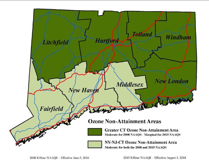
Table of Contents
1.        Executive Summary................................................................................................................................... 3
2.        What is Transportation Conformity? ....................................................................................................... 5
3.        Nonattainment and Maintenance Areas in Connecticut ......................................................................... 5
     a.      Ozone Nonattainment Areas ................................................................................................................ 5
     b.      PM2.5 Maintenance Area ..................................................................................................................... 7
     c.      Carbon Monoxide Maintenance Areas ................................................................................................ 8
     d.      PM10 Attainment Area – Limited Maintenance .................................................................................. 8
     e.      State of Connecticut Nonattainment/Attainment Maps .................................................................... 9
4.        How Does Connecticut Demonstrate Conformity? ............................................................................... 11
     a.      Transportation Planning Work Program ............................................................................................ 11
     b.      Interagency Consultation.................................................................................................................... 11
     c.      Public Consultation ............................................................................................................................. 12
     d.      Scenario Years ..................................................................................................................................... 12
     e.      Other Planning Documents ................................................................................................................ 13
5.        Latest Planning Assumptions and Emissions Model ............................................................................. 13
     a.      VMT ..................................................................................................................................................... 13
     b.      Emissions Model ................................................................................................................................. 14
6.        Conformity Tests and Air Quality Emissions Results ............................................................................. 15
7.        Conclusions ............................................................................................................................................. 17
8.        Contact Information................................................................................................................................ 17
9.        Appendices .............................................................................................................................................. 17

                                                                                                                                                      Page 2 of 33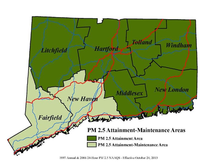
1. Executive Summary
This report documents the air quality conformity analysis of the 2019-2045 Metropolitan Transportation
Plans (MTPs) and the 2018-2021 Transportation Improvement Programs (TIPs), as carried out under the
regulations contained in the United States Environmental Protection Agency’s (EPA) final rule, published in
the November 24, 1993 Federal Register, with subsequent amendments and additional federal guidance
published by EPA, the Federal Highway Administration (FHWA) and the Federal Transit Administration (FTA).
The process involved consultation with affected agencies such as EPA, FHWA, FTA, the Connecticut
Department of Energy and Environmental Protection (CTDEEP) and the Metropolitan Planning Organizations
(MPOs) within the State of Connecticut. The air quality emissions analysis is a responsibility of the
Connecticut Department of Transportation (CTDOT), acting as the MPO for this task.
"Conformity" is a requirement of the Federal Clean Air Act Amendments (CAAA) Section 176(c) (42
U.S.C.7506(c)) and EPA conformity regulations (40 CFR 93 Subpart A). These regulations require that each
new MTP and TIP be demonstrated to conform to the State Implementation Plan (SIP) before the MTP and
TIPs are approved by the MPO or accepted by the United States Department of Transportation (USDOT). This
ensures that the MTP and TIPs are consistent with air quality goals and that progress is being made towards
achieving and maintaining Federal air quality standards. A conformity determination is undertaken to
estimate emissions that will result from an area’s transportation system. The analysis must demonstrate
that those emissions are within limits outlined in state air quality implementation plans.
Under the transportation conformity regulation, the principal criteria for a determination of conformity for
transportation plans and programs are:
The TIP and MTP must pass an emissions budget test using a motor vehicle emissions budget (MVEB)
that has been found to be adequate by EPA for transportation conformity purposes, or an interim
emission test;
The latest planning assumptions and emission models specified for use in conformity determinations
must be employed;
The TIP and MTP must provide for the timely implementation of transportation control measures
(TCMs) specified in the applicable air quality implementation plans; and
Interagency and public consultation.
As the federal air quality districts for ozone and PM2.5 include several counties and various planning regions,
the emission analysis must be coordinated to include the TIPs and MTPs of several regions.
The CTDOT performs this coordination role. Each region submits its draft TIP and MTP to the CTDOT and the
CTDOT in turn combines the TIPs and MTPs for all appropriate regions and conducts the analysis on each
pollutant’s impact for each air quality district in relation to the established MVEBs.
For the 2019-2045 MTP and the 2018-2021 TIPs, summer day emission estimates for ozone precursors,
volatile organic compounds (VOC) and nitrogen oxides (NOx), and annual emission estimates for particulate
matter 2.5 microns or smaller (PM2.5) and NOx as a precursor were developed for years 2018, 2020, 2023,
2025, 2035, and 2045 forecast years. These emission estimates were calculated using EPA’s Motor Vehicle
Emission Simulator (MOVES2014b).
Page 3 of 33
The results of this analysis, in Tables 1 and 2 below show that the 2019-2045 MTP and the 2018-2021 TIPs
mobile emissions are within the MVEBs for all forecast years per pollutant. This analysis provides a basis for
a determination of conformity for the 2019-2045 MTP and the 2018-2021 TIP.

Table 1: Ozone Conformity - NOx and VOC Emissions Budget Test Results

                                                                     Tons per day
 Year      Ozone Area                            Series 31G              Budgets             Difference
                                           VOC          NOx         VOC      NOx         VOC       NOx
           CT Portion of NY-NJ-CT Area     16.61        23.74       17.6     24.6        - 0.99    - 0.86
 2018
           Greater CT Area                 14.96        21.18       15.9     22.2        - 0.94    - 1.02
 2020      Greater CT Area                 13.54        17.84       15.9     22.2        - 2.36    - 4.36
 2023      CT Portion of NY-NJ-CT Area     13.06        15.70       17.6     24.6        - 4.54    - 8.90
           CT Portion of NY-NJ-CT Area     12.39        13.94       17.6     24.6        - 5.21    -10.66
 2025
           Greater CT Area                 11.18        12.53       15.9     22.2        - 4.72    - 9.67
           CT Portion of NY-NJ-CT Area      7.27         8.45       17.6     24.6        -10.33 -16.15
 2035
           Greater CT Area                  6.49         7.53       15.9     22.2        - 9.41    -14.67
           CT Portion of NY-NJ-CT Area      6.41         7.85       17.6     24.6        -11.19 -16.75
 2045
           Greater CT Area                  5.76         7.01       15.9     22.2        -10.14 -15.19

Table 2: PM2.5 Conformity - Direct PM2.5 and NOx Emission Budget Test Results

                                                                    Tons per year
                                                Series 31G              Budgets             Difference
  Year             PM2.5 Area
                                            Direct                  Direct               Direct
                                                         NOx                  NOx                   NOx
                                            PM2.5                   PM2.5                 PM2.5
  2018     CT Portion of NY-NJ-CT Area      318.1       7,837.5     575.8 12,791.8       -257.7 -4,954.3
  2025     CT Portion of NY-NJ-CT Area      221.6       4,707.9     516.0    9,728.1     -294.4 -5,020.2
  2035     CT Portion of NY-NJ-CT Area      169.2       2,987.4     516.0    9,728.1     -346.8 -6,740.7
  2045     CT Portion of NY-NJ-CT Area      152.4       2,803.5     516.0    9,728.1     -363.6 -6,924.6

                                                                                                 Page 4 of 33
2. What is Transportation Conformity?
Transportation conformity is a planning process required by the CAA Section 176(c), which establishes the
framework for improving air quality to protect public health and the environment. The goal of transportation
conformity is to ensure that FHWA and FTA funding and approvals are given to highway and public
transportation activities that are consistent with air quality goals.
The CAA requires that metropolitan transportation plans, TIPs, and Federal projects conform to the purpose
of the SIP. Conformity to a SIP means that such activities will not cause or contribute to any new violations
of the National Ambient Air Quality Standards (NAAQS); increase the frequency or severity of NAAQS
violations; or delay timely attainment of the NAAQS or any required interim milestone. Conformity
requirements apply in areas that either do not meet or previously have not met air quality standards for
ozone, carbon monoxide, particulate matter, or nitrogen dioxide. These areas are known as “nonattainment
areas” or “maintenance areas”, respectively.
Connecticut contains nonattainment areas for ozone (O3) and maintenance areas for carbon monoxide (CO)
and PM2.5.
For MTP and TIP conformity, the determination shows that the total emissions from on-road travel on an
area’s transportation system are consistent with the MVEBs and goals for air quality found in the state’s SIP.
A conformity determination demonstrates that implementation of the MTP or TIP will not cause any new
violations of the air quality standard, increase the frequency or severity of violations of the standard, or delay
timely attainment of the standard or any interim milestone.
This document was developed by the CTDOT to demonstrate that the MTP, comply with the MVEBs for the
nonattainment and maintenance areas that fall within the state’s planning boundary. In accordance with
EPA regulation 40 CFR 93 Subpart A, this conformity determination is being issued in response to the
adoption of new MTPs.
In addition, the conformity determination demonstrates compliance with the congestion management
process in transportation management areas (23 CFR §450.322), development and content of the MTP (23
CFR §450.324), and fiscal constraints for MTPs and TIPs (40 CFR §93.108-119).
3. Nonattainment and Maintenance Areas in Connecticut
a. Ozone Nonattainment Areas
Ozone is an extremely reactive, colorless gas comprised of three atoms of oxygen. Ozone exists naturally in
a layer of the earth's upper atmosphere known as the stratosphere, where it shields the earth from the sun's
harmful ultraviolet rays. However, ozone found close to the earth's surface, called ground-level ozone, is a
component of smog and a harmful pollutant. Ground-level ozone is produced by a complex chemical reaction
between VOCs and NOx in the presence of sunlight.
Mobile source NOx emissions form when nitrogen and oxygen atoms chemically react inside the high
pressure and temperature conditions in an engine. VOC emissions are a product of partial fuel combustion,
fuel evaporation and refueling losses caused by spillage and vapor leakage.
Exposure to ozone has been linked to a number of respiratory health effects, including significant decreases
in lung function, inflammation of airways, and increased symptoms such as cough and pain when breathing
deeply. High concentrations of ozone can also contribute to reductions in agricultural crop production and
forest yields, as well as increased susceptibility of plants to disease, pests and other environmental stresses
Page 5 of 33such as harsh weather. This pollutant alone contributes to the majority of unhealthy air quality days in
Connecticut, as measured by the Air Quality Index (AQI).
EPA revised the ozone NAAQS in 2008 and again in 2015. The 2008 ozone NAAQS was established at 75 ppb
and the 2015 ozone NAAQS revised the standard to 70 ppb. States and portions of states are then
subsequently classified as attainment (meeting the standard) or one of the following classifications of
nonattainment: marginal, moderate, serious, severe and extreme. The classifications indicate the severity of
the exceedance are defined in rules that proceed a newly promulgated NAAQS. Connecticut is nonattainment
for both standards and as such must contend with the subsequent nonattainment requirements for both
standards. More specifically, under the 2008 standard Connecticut’s two nonattainment areas were
originally designated as marginal and have subsequently been reclassified as moderate. Under the 2015
standard the southwest portion of the state, known as the New York-Northern New Jersey-Long Island (NY-
NJ-CT) ozone nonattainment area, is designated as moderate and the rest of the state, known as the Greater
Connecticut ozone non-attainment area, is designated as marginal.1
Under the 2008 standard, the Connecticut ozone nonattainment areas were subsequently reclassified to
moderate. EPA determined that 11 of the original marginal areas did not attain the 2008 ozone standards by
the July 20, 2015 attainment date and that they must be reclassified as moderate. Both the Greater
Connecticut and the Connecticut portion of the NY-NJ-CT nonattainment areas were two of the eleven areas.2
The “bump- up” designation to moderate was effective on June 3, 2016.
In this action, the EPA also established a due date of January 1, 2017, by which states with newly reclassified
moderate areas must submit SIP revisions to address moderate nonattainment area requirements for those
areas. The reclassified areas must attain the 2008 ozone standards by the July 20, 2018 moderate attainment
deadline. Neither of Connecticut’s nonattainment areas measured compliance by the deadline. As such, on
November 14, 2018, EPA proposed to reclassify both areas as serious under the 2008 standard. However,
this action is not yet final. Therefore, Connecticut remains moderate under the 2008 standard.
On March 20, 2017, EPA notified CTDEEP that EPA had determined the 2017 MVEBs for the Greater
Connecticut ozone nonattainment area, submitted as a SIP revision by CTDEEP to EPA on January 17, 2017,
to be adequate for transportation conformity purposes. On May 31, 2017, EPA published its adequacy finding
in the Federal Register (82 FR 24859) and the MVEBs became effective on June 15, 2017 for transportation
conformity purposes.
On June 4, 2018, EPA published a final rule that designated new nonattainment areas for the 2015 Ozone
NAAQS (83 FR 25776). These designations were effective on August 3, 2018. Therefore, conformity of
transportation plans and TIPs for the 2015 Ozone NAAQS must be demonstrated by August 3, 2019. This
analysis demonstrates conformity to the new 2015 Ozone NAAQS for both Connecticut non-attainment
areas.
On October 1, 2018, EPA published a final rule approving certain SIP revisions relating to the 2008 8-hour
Ozone NAAQS (83 FR 49297), including approval of the MVEB as shown in Table 3.
1
83 FR 25776
2
81 FR 26697
Page 6 of 33Table 3: Approved Motor Vehicle Emissions Budgets - Ozone
VOC NOx
Year Area
(tons/summer day) (tons/summer day)
Connecticut portion of the New York-
2017 Northern New Jersey-Long Island, NY-NJ-CT 17.6 24.6
Ozone Area
2017 Greater Connecticut Ozone Area 15.9 22.2
CTDEEP will be required to address the MVEBs again in the attainment demonstration for the 2015 ozone
NAAQS. The attainment demonstration for the 2015 ozone NAAQS is due August 3, 2021.
Additionally, MVEBs will need to be addressed for the 2008 ozone NAAQS should the EPA finalize the
reclassification proposed on November 14, 2018. Deadlines for this reclassification will be set upon the
effective date of the final rule.
b. PM2.5 Maintenance Area
Fine particulate matter, also called PM2.5, is a mixture of microscopic solids and liquid droplets suspended
in air, where the size of the particles is equal to or less than 2.5 micrometers (about one-thirtieth the
diameter of a human hair). Fine particles can be emitted directly (such as smoke from a fire, or as a
component of automobile exhaust) or be formed indirectly in the air from power plant, industrial and mobile
source emissions of gases such as sulfur dioxide and nitrogen oxides.
The health effects associated with exposure to fine particles are serious. Scientific studies have shown
significant associations between elevated fine particle levels and premature death. Effects associated with
fine particle exposure include aggravation of respiratory and cardiovascular disease (as indicated by
increased hospital admissions, emergency room visits, absences from school or work, and restricted activity
days), lung disease, decreased lung function, asthma attacks, and certain cardiovascular problems such as
heart attacks and cardiac arrhythmia. While fine particles are unhealthy for anyone to breathe, people with
heart or lung disease, asthmatics, older adults, and children are especially at risk.
In December of 2004, EPA signed the final rulemaking notice to designate attainment and nonattainment
areas with respect to the PM2.5 NAAQS, becoming effective April 5, 2005. In Connecticut, Fairfield and New
Haven Counties were included in the New York-Northern New Jersey-Long Island, NY-NJ-CT PM2.5
nonattainment area. On June 20, 2007, PM2.5 budgets were found to be adequate for the early progress
SIP. CTDEEP submitted a re-designation request and maintenance plan for the Connecticut portion of the
NY-NJ-CT area on June 22, 2012. The plan demonstrated that Connecticut’s air quality met both the 1997
annual and the 2006 24-hour PM2.5 NAAQS due to a combination of national, regional and local control
measures implemented to reduce emissions and presented a maintenance plan that ensures continued
attainment through the year 2025. The end of the maintenance period was established as 2025, consistent
with the CAA section 175A (a) requirement that the plan provide for maintenance of the NAAQS for at least
10 years after EPA formally approves the re-designation request.
EPA subsequently determined that the 2017 and 2025 MVEBs in the maintenance plan were adequate for
transportation conformity purposes and effective as of February 20, 2013. On September 24, 2013, EPA
published its approval of the PM2.5 re-designation request, establishing October 24, 2013 as the effective
Page 7 of 33date of re-designation to attainment/maintenance for Connecticut’s portion of the NY-NJ-CT area for both
the 1997 annual and 24-hours PM2.5 NAAQS. Table 4 summarizes Connecticut’s current PM2.5 MVEBs.
Table 4: Approved Motor Vehicle Emissions Budgets – PM2.5
Direct PM2.5 NOx
Year Area
(tons/year) (tons/year)
Connecticut portion of the New York-
2017 Northern New Jersey-Long Island, NY-NJ-CT 575.8 12,791.8
PM2.5 Area
Connecticut portion of the New York-
2025 Northern New Jersey-Long Island, NY-NJ-CT 516.0 9,728.1
PM2.5 Area
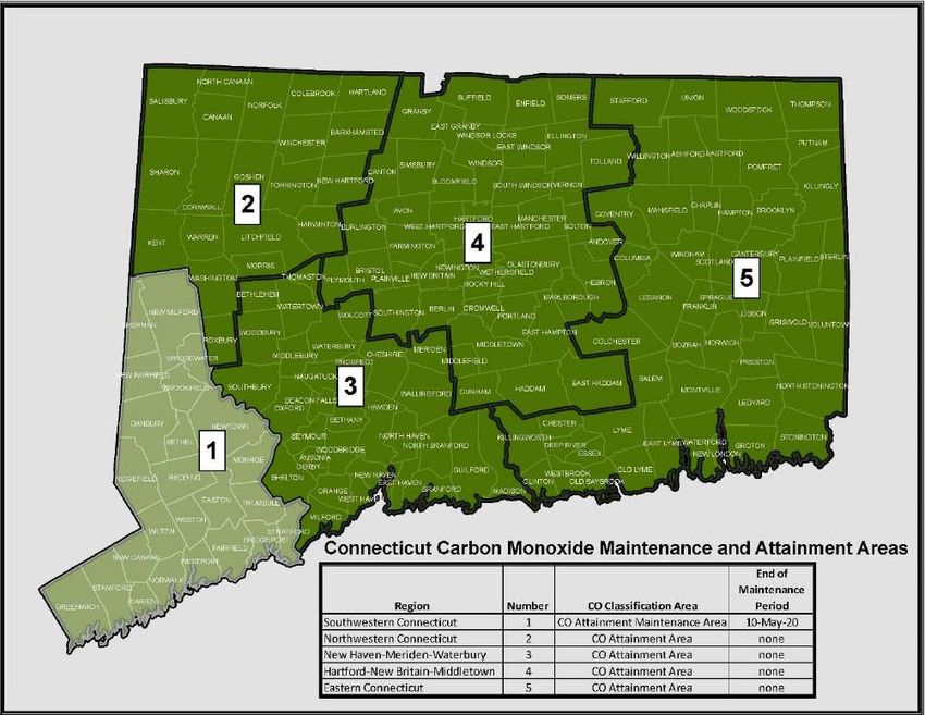
c. Carbon Monoxide Maintenance Areas
Carbon monoxide is produced by the incomplete burning of carbon in fuels, including gasoline. High
concentrations of CO occur along roadsides in heavy traffic, particularly at major intersections and in
enclosed areas such as garages and poorly ventilated tunnels. Peak concentrations occur during the colder
months of the year when CO vehicular emissions are greater and meteorological inversion conditions occur
more frequently, trapping pollutants near the ground.
There were formerly three CO nonattainment areas in the state. These were the Southwestern portion of
the state, the New Haven-Meriden-Waterbury area, and the Hartford-New Britain-Middletown area. The
remainder of the state was in attainment for CO. Attainment was demonstrated in each of the
nonattainment areas and, subsequently, they were designated as full maintenance areas. On September 13,
2004, EPA approved a CTDEEP submittal for a SIP revision for re-designation of these areas to limited
maintenance plan status, thus eliminating the need for budget testing. Effective January 2, 2016, the
Hartford-New Britain-Middletown area was in full attainment status. The New Haven-Meriden-Waterbury
area completed the maintenance period effective December 4, 2018 while the Southwestern Connecticut
area will be effective May 10, 2020. In the future, “hot-spot” carbon monoxide analyses will be performed
to satisfy “project level” conformity determinations.
d. PM10 Attainment Area – Limited Maintenance
EPA previously designated the City of New Haven as nonattainment with respect to the NAAQS for particulate
matter with a nominal diameter of ten microns or less (PM10). The PM10 nonattainment status in New
Haven was a local problem stemming from activities of several businesses located in the Stiles Street section
of the city. Numerous violations in the late 1980’s and early 1990’s of Section 22a-174-18 (Fugitive Dust) of
CTDEEP regulations in that section of the city led to a nonattainment designation (CTDEEP, 1994: Narrative
Connecticut Department of Energy and Environmental Protection, State Implementation Plan Revision, For
PM10, March 1994). Corrective actions were subsequently identified in the SIP and implemented, with no
violations of the PM10 NAAQS since the mid-1990s.
On October 13, 2005, EPA published in the Federal Register (70 FR 59690), approval of a request by CTDEEP
for a limited maintenance plan and re-designation of the New Haven nonattainment area to attainment for
the PM10 NAAQS. This direct final rule became effective on December 12, 2005.
All construction activities undertaken in the City of New Haven are required to be performed in compliance
with Section 22a-174-18 (Control of Particulate "Emissions") of the CTDEEP regulations. All reasonable
Page 8 of 33available control measures must be implemented during construction to mitigate particulate matter
emissions, including wind-blown fugitive dust, mud and dirt carry out, and re-entrained fugitive emission
from mobile equipment.
As with limited maintenance plans for other pollutants, emissions budgets are considered to satisfy
transportation conformity’s “budget test”. However, future “project level” conformity determination may
require “hot spot” PM10 analyses for new transportation projects with significant diesel traffic in accordance
with EPA’s Final Rule for “PM2.5 and PM10 Hot-Spot Analyses in Project-level Transportation Conformity
Rule PM2.5 and PM10 Amendments; Final Rule (75 FR 4260, March 24, 2010) which became effective on
April 23, 2010.
e. State of Connecticut Nonattainment/Attainment Maps
Figure 1: Connecticut Ozone Nonattainment Areas
Page 9 of 33Figure 2: Connecticut PM2.5 Attainment/Maintenance Area
Page 10 of 33Figure 3: Connecticut Carbon Monoxide Maintenance and Attainment Areas
4. How Does Connecticut Demonstrate Conformity?
a. Transportation Planning Work Program
CTDOT’s FY 2019-2020 Transportation Planning Work Program contains a description of all planning efforts,
including those related to air quality, to be sponsored or undertaken with federal assistance during FY 2019
and 2020. Included with this program are several tasks directly related to CTDOT's responsibilities under
Connecticut's air quality SIP. Additional functions, such as those supporting the preparation of project level
conformity analysis, are funded under project related tasks. This work program is available at CTDOT for
review.
b. Interagency Consultation
The conformity rule requires that Federal, State, and local transportation and air quality agencies establish
formal procedures to ensure interagency coordination on critical issues. Interagency consultation is a
collaborative process between organizations on key elements of the transportation and air quality planning
and provides a forum for effective state and local planning and decision-making.
Page 11 of 33Key organizations included in the interagency consultation are FHWA, FTA, EPA, CTDOT, CTDEEP and the
MPOs.
Some goals of interagency consultation are to:
• Ensure all agencies meet regularly and share information;
• Identify key issues early in the process;
• Enable well-coordinated schedules for TIP/MTP conformity determinations and SIP development;
and
• Allow collaborative decision on methodologies, assumptions and conformity test selections.
A list of attendees and call-in participants of the Interagency Consultation Meeting is included in Appendix C
along with a copy of the minutes from the meeting.
c. Public Consultation
The transportation conformity process must also include public consultation on the emissions analysis and
conformity determination. This includes posting of relevant documentation and analysis on a
“clearinghouse” webpage maintained through the interagency consultation process. All MPOs in the
affected nonattainment or maintenance areas must provide thirty-day public comment periods and address
any comments received. For this transportation conformity determination, all Connecticut MPOs will hold a
thirty-day public comment period. If any public comments were received, they will be attached and can be
found in Appendix E.
d. Scenario Years
The “Action Scenario” is the future transportation system that will result from full implementation of the
MTP.
VOC/NOx emission analysis was conducted for ozone season summer day conditions for the following years:
• 2018 (Attainment year and near term analysis year)
• 2020 (Attainment year for the Greater CT Marginal nonattainment area under the 2015 Ozone
NAAQS)3
• 2023 (Attainment year for the CT portion of NY-NJ-CT Moderate nonattainment area under the 2015
Ozone NAAQS)3
• 2025 (Interim modeling year)
• 2035 (Interim modeling year)
• 2045 (Metropolitan Transportation Plan horizon year)
PM2.5 emission analysis was conducted for the following years but for annual average conditions:
• 2018 (Attainment year and near term analysis year)
• 2025 (Interim modeling year)
• 2035 (Interim modeling year)
• 2045 (Metropolitan Transportation Plan horizon year)
3
Per March 20, 2019 email from Ariel Garcia, Senior SIP Coordinator, Air Quality Unit, EPA Region 1. “The reason
being is that going-forward EPA will rely on the definition of “Attainment Year” to refer to the year containing the last
fully completed ozone season preceding the attainment date…”
Page 12 of 33e. Other Planning Documents
The enaction of Section 81 of Connecticut Public Act 13-277 repealed Section 13b-15 of the Connecticut
General Statutes, no longer mandating a biennial Master Transportation Plan effective July 1, 2013. The
Department’s Capital Plan has been expanded to include much of the project information that was formerly
included in the Master Transportation Plan. In addition, the Existing Systems document, the Statewide Long
Range Transportation Plan and “Let’s GO CT!” contain other information that was included in various Master
Transportation Plans.
5. Latest Planning Assumptions and Emissions Model
a. VMT
Vehicle miles of travel (VMT) estimates were developed from CTDOT's statewide network-based travel
demand model, Series 31G. The 2018 travel model network, to the extent practical, represents all state
highways and major connecting non-state streets and roads, as well as the rail, local bus, and express bus
systems that currently exist. Future highway networks for 2020, 2025, 2028, 2030, 2035 and 2045 and transit
networks for 2020, 2025, 2030, and 2045 were built by adding MTP projects (programmed for opening after
2018) to the 2018 network year. These networks were used to run travel demand models and conduct
emissions analyses for the years 2018, 2020, 2023, 2025, 2035, and 2045. Projects for each model analysis
year for which network changes were required are listed in Appendix B.
It should be noted that MTP projects, which have negligible impact on trip distribution and/or highway
capacity, have not been incorporated into the network. These include, but are not limited to, geometric
improvements of existing interchanges, short sections of climbing lanes, intersection improvements, transit
projects dealing with equipment for existing facilities and vehicles, and transit operating assistance. Other
projects that reduce the number of vehicle trips, VMT or both may not be included. Such projects include
ridesharing and telecommuting programs, bicycling facilities, clean fuel vehicle programs or other possible
actions. These types of considerations, while not explicitly accounted for in the travel demand model, will
continue to reduce the emissions levels in the regions. Essentially, those projects that do not impact the
travel demand forecasts are not included in the networks and/or analysis.
The network-based travel model used for this analysis is the model that CTDOT utilizes for transportation
planning, programming and design requirements. This travel demand model uses demographic and land use
assumptions based on the 2011-2015 American Community Survey 5-Year Estimates population and
Connecticut Department of Labor 2015 employment estimates. Population and employment projections for
the years 2020, 2030, 2040 and 2050 were developed by the Connecticut Department of Transportation,
Travel Demand and Air Quality Modeling Unit.
The model uses a constrained equilibrium approach to allocate trips among links. The model was calibrated
using 2015 ground counts and 2015 Highway Performance Monitoring System (HPMS) Vehicle Miles of Travel
data.
In addition, the Employer Commute Options (ECO) Program has been made available to all employers and is
incorporated in the travel demand model. It is felt that this process is an effective means of achieving
Connecticut's clean air targets. Funding of this effort under the Congestion Mitigation and Air Quality
Improvement (CMAQ) program is included in the TIP for FY 2018-2021. It is estimated that this program, if
fully successful, could reduce VMT and mobile source emissions by 2% in Southwest Connecticut.
Page 13 of 33Peak hour directional traffic volumes were estimated as a percentage of the Average Daily Traffic (ADT) on a
link-by-link basis. Based on automatic traffic recorder data, 9.0 percent, 8.5 percent, 8.0 percent and 7.5
percent of the ADT occurs during the four highest hours of the day. A 55:45 directional split was assumed.
Hourly volumes were then converted to Service Flow Levels (SFL) and Volume to Capacity (V/C) ratios
calculated as follows:
SFL = DHV / PHF * N
VC = SFL / C
where: DHV = Directional Hourly Volume
PHF = Peak Hour Factor = 0.9
N = Number of lanes
C = Capacity of lane
Peak period speeds were estimated from the 2000 Highway Capacity Manual based on the design speed,
facility class, area type and calculated V/C ratio. On the expressway system, Connecticut- based free flow
speed data was available. This data was deemed more appropriate and superseded the capacity manual
speed values. The expressway free flow speeds were updated in 2005.
For the off-peak hours, traffic volume is not the controlling factor for vehicle speed. Off-peak link speeds
were based on the Highway Capacity Manual free flow speeds as a function of facility class and area type. As
before, Connecticut-based speed data was substituted for expressway travel, where available, and was
updated in 2005.
ShoreLine East, Hartford Rail Line, New Haven Rail Line, and its branch line schedules were updated in 2018
to reflect new headways and routes. Rail station boardings were then calibrated to 2015 actual counts in
2018 for both A.M. peak period and Midday off-peak service along all Connecticut rail lines.
Two special cases exist in the travel demand modeling process. These are centroid connectors and intrazonal
trips:
• Centroid connectors represent the local roads used to gain access to the model network from centers
of activity in each traffic analysis zone (TAZ). A speed of 25 mph is utilized for these links; and
• Intrazonal trips are trips that are too short to get on to the model network. VMT for intrazonal trips
is calculated based on the size of each individual TAZ. A speed of 20 to 24 mph is utilized for peak
period and 25 to 29 mph for off-peak.
The Daily Vehicle Miles of Travel (DVMT) is calculated using a methodology based on disaggregate speed and
summarized by inventory area, functional classification, and speed. The annual VMT and speed profiles
developed by this process are then combined with the emission factors from the MOVES2014b model to
produce emission estimates for each scenario and time frame.
b. Emissions Model
For this transportation conformity analysis, the MOVES model, specifically MOVES2014b, was used to
estimate on-road vehicle emissions for the action scenarios. MOVES is a state-of-the-science emission
modeling system, developed by EPA, that estimates emissions for mobile sources at the national, county,
and project level for criteria air pollutants, greenhouse gases, and air toxics.
Page 14 of 33MOVES estimates exhaust and evaporative emissions as well as brake and tire wear emissions from all types
of on-road vehicles. It also uses a vehicle classification system based on the way vehicles are classified in the
FHWA’s Highway Performance Monitoring System (HPMS). Other parameters include VMT by vehicle and
road type, vehicle hours traveled (VHT) by vehicle and road type, the number of each type of vehicle in the
fleet, vehicle age distribution, model year, travel speed, roadway type, fuel information, meteorological data,
such as ambient temperature and humidity, and applicable control measures such as reformulated gasoline
(RFG) and inspection and maintenance (I/M) programs. Local inputs were cooperatively developed by
CTDEEP and CTDOT, where applicable, using EPA recommended methods.4
The HPMS Vehicle Mix file was updated to reflect the average vehicle mix for the 2015-2017 timeframe. A
Three year average was determined to be a more accurate representation of actual vehicle mix than the
previous one year counts as the CTDOT rotates traffic and vehicle counts on a three-year basis.
CTDEEP supplemented the 2011 DMV vehicle registration data with 2018 DMV vehicle registration data for
motorcycle (source type 11) and school buses (source type 43).
In November 2012, EPA confirmed by telephone to CTDEEP that future conformity determinations utilizing
newer versions of MOVES can be made by comparing emission results to the existing budgets based on older
versions of MOVES. As new MVEBs are determined by EPA to be adequate for each area, they will be used
to make conformity determinations.
For the ozone analysis, MOVES was only run to obtain VOC and NOx emissions on a typical summer weekday
to compare to the ton per summer day ozone MVEBs. For the PM2.5 analyses, an annual emissions run was
conducted for PM2.5 and NOx to compare to the ton per year PM2.5 MVEBs. All runs also included the
National Low Emission Vehicle (NLEV) program in 2008 and all future years.
6. Conformity Tests and Air Quality Emissions Results
For the NY-NJ-CT ozone nonattainment area, VOC and NOx transportation emissions from the Action
Scenarios must be less than the 2017 transportation emission budgets if analysis year is 2017 or later.
For the Greater Connecticut ozone nonattainment area, VOC and NOx transportation emissions from the
Action Scenarios must be less than the 2017 transportation emission budgets if analysis year is 2017 or later.
For the NY-NJ-CT PM2.5 maintenance area, PM2.5 and NOx transportation emissions from the Action
Scenarios must be less than the 2017 transportation emission budgets if analysis year is between 2017 and
2024.
For the NY-NJ-CT PM2.5 maintenance area, PM2.5 and NOx transportation emissions from the Action
Scenarios must be less than the 2025 transportation emission budgets if analysis year is 2025 or later.
No tests for CO are required because the CO areas have been approved by EPA for Limited Maintenance Plan
status.
4
“MOVES2014, MOVES2014a, and MOVES2014b Technical Guidance: Using MOVES to Prepare Emission Inventories
for State Implementation Plans and Transportation Conformity”, EPA-420-B-18-039, August 2018.
Page 15 of 33The following tables show the MOVES2014b modeled emissions for both ozone and PM2.5 areas compared
to the applicable MVEBs for each pollutant. In all cases, the Metropolitan Transportation Plans meet the
required conformity tests.
Table 5: Ozone Conformity - NOx and VOC Emissions Budget Test Results
Tons per day
Year Ozone Area Series 31G Budgets Difference
VOC NOx VOC NOx VOC NOx
CT Portion of NY-NJ-CT Area 16.61 23.74 17.6 24.6 - 0.99 - 0.86
2018
Greater CT Area 14.96 21.18 15.9 22.2 - 0.94 - 1.02
2020 Greater CT Area 13.54 17.84 15.9 22.2 - 2.36 - 4.36
2023 CT Portion of NY-NJ-CT Area 13.06 15.70 17.6 24.6 - 4.54 - 8.90
CT Portion of NY-NJ-CT Area 12.39 13.94 17.6 24.6 - 5.21 -10.66
2025
Greater CT Area 11.18 12.53 15.9 22.2 - 4.72 - 9.67
CT Portion of NY-NJ-CT Area 7.27 8.45 17.6 24.6 -10.33 -16.15
2035
Greater CT Area 6.49 7.53 15.9 22.2 - 9.41 -14.67
CT Portion of NY-NJ-CT Area 6.41 7.85 17.6 24.6 -11.19 -16.75
2045
Greater CT Area 5.76 7.01 15.9 22.2 -10.14 -15.19
Table 6: PM2.5 Conformity - Direct PM2.5 and NOx Emission Budget Test Results
Tons per year
Series 31G Budgets Difference
Year PM2.5 Area
Direct Direct Direct
NOx NOx NOx
PM2.5 PM2.5 PM2.5
2018 CT Portion of NY-NJ-CT Area 318.1 7,837.5 575.8 12,791.8 -257.7 -4,954.3
2025 CT Portion of NY-NJ-CT Area 221.6 4,707.9 516.0 9,728.1 -294.4 -5,020.2
2035 CT Portion of NY-NJ-CT Area 169.2 2,987.4 516.0 9,728.1 -346.8 -6,740.7
2045 CT Portion of NY-NJ-CT Area 152.4 2,803.5 516.0 9,728.1 -363.6 -6,924.6
Emission Summary Tables are posted in Appendix D.
This analysis in no way reflects the full benefit in air quality from the MTPs. The network-based modeling
process is capable of assessing the impact of major new highway or transit service. It does not reflect the
impact from the many projects, which are categorically excluded from the requirement of conformity. These
projects include numerous improvements to intersections, which will allow traffic to flow more efficiently,
thus reducing delay, fuel usage and emissions. Included in the MTPs, but not reflected in this analysis, are
many projects to maintain existing rail and bus systems. Without these projects, those systems could not
offer the high level of service they do. With them, the mass transit systems function more efficiently, improve
safety, and provide a more dependable and aesthetically appealing service. These advantages will retain
existing patrons and attract additional riders to the system. The technology to quantify the air quality
benefits from these programs is not currently available.
Changes in the transportation system will not produce significant emissions reductions because of the
massive existing rail, bus, highway systems, and land development already in place. Change in these aspects
is always at the margin, producing very small impacts.
Page 16 of 33As shown in this analysis, transportation emissions are declining dramatically and will continue to do so. This
is primarily due to programs such as federal heavy-duty vehicle standards, reformulated fuels, enhanced
inspection and maintenance programs, and Connecticut’s low emissions vehicle (LEV) program.
7. Conclusions
CTDOT has assessed its compliance with the applicable conformity criteria requirements of the 1990 CAAA.
Based upon this analysis, it is concluded that all elements of Metropolitan Transportation Plans conform to
applicable SIP and 1990 CAAA Conformity Guidance criteria and the approved transportation conformity
budgets.
8. Contact Information
Please direct any questions you may have on the air quality emission analysis to:
Connecticut Department of Transportation
Bureau of Policy and Planning
Division of Coordination, Modeling and Crash Data
Travel Demand / Air Quality Modeling Unit
2800 Berlin Turnpike
Newington, CT. 06111
(860) 594-2032
Email: Judy.Raymond@ct.gov
All MOVES modeling files and runstreams are available for review upon request on the Department’s MOVES
FTP site. The files will remain available during the 30-day public review period.
9. Appendices
In addition to the information required for a conformity determination, the following is attached:
Appendix A: Acronyms
Appendix B: List of Projects Included in Conformity Analysis by Network Year
Appendix C: Interagency Consultation Meeting
Appendix D: Emissions Summary Tables
Appendix E: Comments Received During Public Review Period
Page 17 of 33Appendix A
Acronyms
Page 18 of 33Acronym Meaning
ADT Average Daily Traffic
AQI Air Quality Index
CAAA Clean Air Act Amendments (1990)
CO Carbon Monoxide
CFR Code of Federal Regulations
CTDEEP Connecticut Department of Energy and Environmental Protection
CTDOT Connecticut Department of Transportation
CMAQ Congestion Mitigation and Air Quality Improvement Program
DHV Design Hourly Volume
DVMT Daily Vehicle Miles of Travel
ECO Employee Commute Option
EPA Environmental Protection Agency
FHWA Federal Highway Administration
FTA Federal Transit Administration
FTP File Transfer Protocol
FR Federal Register
HPMS Highway Performance Monitoring System
I/M Inspection Maintenance Program
MTP Metropolitan Transportation Plan
MOVES Mobile Vehicle Emission Simulator
MPO Metropolitan Planning Organization
MVEB Motor Vehicle Emission Budget
NAAQS National Ambient Air Quality Standards
NLEV National Low Emission Vehicle
NOx Nitrogen Oxides
PHF Peak Hour Factor
PM2.5 Fine Particulate Matter less than 2.5 micrometers
PM10 Fine Particulate Matter less than 10 micrometers
SFL Service Flow Levels
SIP State Implementation Plan
STIP Statewide Transportation Improvement Program
TAZ Traffic Analysis Zone
TCM Transportation Control Measure
TIP Transportation Improvement Program
U.S.C. United States Code
U.S. DOT U.S. Department of Transportation
V/C Volume to Capacity
VHT Vehicle Hours Traveled
VMT Vehicle Miles Traveled
VOC Volatile Organic Compound
Page 19 of 33Appendix B
List of Projects Included in Conformity Analysis by Network Year
Page 20 of 33Network
MPO Project # Town Route/Street Number Project Description
Year
CRCOG Various CTFastrak CTFastrak Stations & Fixed Guideway 2015
GBVMPO 0036-0179 Derby Route 8 Reconstruct interchanges 16 & 17; extend Pershing Drive & construct local roads 2016
CNV MPO 0017-0182 Bristol Route 6 Addition of a second through lane on Route 6 Eastbound from Carol Drive to Peggy Lane 2018
TIGER Grant includes various roadway changes including reconstruction/extension of Jackson Street.
CNV MPO 0051-xxxx Waterbury Various 2018
Extension will meet at Freight Street and continue to West Main
CRCOG 0051-0259 Farmington I-84/Route 4/Route 6 Interchange BSWY 2018
CRCOG Hartford Hartford Line Hartford Line - Existing Stations - Hartford 2018
GBVMPO 0138-0211 Stratford Route 1 Addition of a through lane on Rt 1 Southbound from Nobel Street to Soundview Avenue 2018
MULTIPLE 0170-2296 Berlin Hartford Line Hartford Line - Existing Stations - Berlin 2018
MULTIPLE 0170-2296 Various Hartford Line Hartford Line - Grade Crossing Elimination Program 2018
MULTIPLE 0170-2296 Meriden Hartford Line Hartford Line - Existing Stations - Meriden 2018
MULTIPLE 0170-2296 Wallingford Hartford Line Hartford Line - Existing Stations - Wallingford 2018
MULTIPLE 0320-0015 Various Hartford Line Hartford Line-Windsor Station (FDP 9/16/2020) 2018
MULTIPLE 0320-0016 Various Hartford Line Hartford Line-Windsor Locks (FDP 10/2/2019) 2018
MULTIPLE Various Various Hartford Line Hartford Line 2018
WESTCOG 0102-0325 Norwalk Route 1 Addition of a through lane on Rt. 1 Northbound from France Street to Rt. 53 2018
WESTCOG 0135-0301 Stamford Atlantic Street Reconstruction of I-95 off ramps and Atlantic Street in vicinity of Metro North Railroad Bridge No. 08012R 2018
CNV MPO 0151-0273 Waterbury I-84 Upgrade Expressway - Phase 3 (80%) 2020
CNV MPO 0124-xxx Seymour Route 113 Between Interchange 22 and 23 to improve access 2020
CNV MPO 0124-xxxx Seymour Route 8 Realign interchange with new extension of Derby Road 2020
CNV MPO 0126-xxxx Shelton Route 8 Interchange 11 - Construct new SB entrance ramp, Widen Bridgeport Avenue 2020
CNV MPO 0126-xxxx Shelton Route 714 Between Huntington Avenue and Constitution Boulevard 2020
Seaview Avenue corridor: Operational improvements to corridor, and north of Rt 1 to provide access for
GBVMPO 0015-0371 Bridgeport Seaview Ave 2020
proposed Lake Success Business Park and future local developments
GBVMPO 0015-xxxx Bridgeport Route 130 Reconstruct and widen Rt 130 from Stratford Avenue bridge to Yellow Mill bridge 2020
Main St Complete Street Implementation: Narrow Main St. from 4 lanes to 3, add buffered bike lanes, expand
GBVMPO Stratford Main St/Route 113 2020
sidewalks and increase landscaped buffer
WESTCOG 0034-0347 Danbury SR 806 (Newtown Rd) Improvements: Old Newtown to Plumtrees and Eagle to Industrial Plaza Rd 2020
WESTCOG 0008-xxxx Danbury White Street Operational Improvements on White Street at Locust Avenue and Eighth Avenue 2020
Improvements on Routes 63, 64 & I-84 WB Interchange 17: Build new connector road and realign existing
CNV MPO 0080-0128 Middlebury I-84/Route 63/Route 64 2025
state routes
NRG Beacon Falls -- Phase II: Naugatuck River Greenway: Extend the road diet along South Main Street and
CNV MPO Beacon Falls NRG 2025
install a multi-use trail
NRG Beacon Falls -- Phase III: Naugatuck River Greenway: Extend the road diet along North Main Street and
CNV MPO Beacon Falls NRG 2025
install a multi-use trail from about Depot Street to Church Street
Route 69 Traffic & Pedestrian Improvements: Optimize signal timing. Provide a lead or lag phase for the NB
CNV MPO Prospect Route 69 2025
Route 69 approach left turners and prohibit the SB left turn onto Scott Road
Main St Safety Improvements: Narrowing lanes, eliminating one of the EB Main St lanes west of the ramps,
CNV MPO Thomaston US Route 6 2025
and providing turn (deceleration) lanes into Pleasant St
East Main St Spot Improvements & Lane configurations: Reconfigure to provide a uniform road width and
CNV MPO Waterbury SR 801 2025
number of lanes – one travel lane in each direction
Safety improvments East Main Street: Remove 1 through lane in eastbound direction between Cherry Street
CNV MPO Waterbury SR 801 2025
and Brass Mill Dr. Shorten pedestrian crossing distances.
Lakewood Road Bus: Add new 1 hour headway service along Lakewood Road. Stagger service with 422 to
CNV MPO Waterbury CT Transit 2025
reduce headways to one half hour on trunk.
CRCOG 0042-0317 East Hartford Route 2 Rt. 2 Operational & Safety Improvements Between Exits 3 and 5 2025
CRCOG 0055-0142 Granby 10/202 Major Intersection Improvement at CT 20/189 2025
CRCOG 0063-0703 Hartford I-91/Route 15 Relocation & Reconfigure Interchange 29 (CN) 2025
CRCOG 0131-0190 Southington CT 10 NHS - Remove Br 00518, reconstruct CT10/322 intersection 2025
Page 21 of 33Network
MPO Project # Town Route/Street Number Project Description
Year
CRCOG 0155-0171 West Hartford I-84 I-84 West Hartford Exits 40 & 42 2025
CRCOG Manchester I-84 Auxiliary lanes between Exits 62 and 63 2025
CRCOG Manchester I-84 Auxiliary lanes between Exits 63 and 64/65 2025
Lafayatte Circle realignment: Realign from a large, irregular one-way circulating configuration to several more
GBVMPO 0015-0368 Bridgeport Route 700 2025
typical roadway intersections connecting several city streets
GBVMPO 0036-0184 Derby Route 34 Reconstruct and widen Main Street from Bridge St. to Ausonio Dr. to 4 travel lanes 2025
GBVMPO 0138-0248 Stratford I-95 Interchange 33: Reconstruct the partial interchange and replace it with a full-directional, diamond interchange. 2025
Route 58 at Black Rock Provide a 4-leg single-lane roundabout: Modify access with Moritz Pl and Rt. 58 to be right-in/right-out access
GBVMPO Fairfield 2025
Tpke. preceding roundabout. Remove access from Rt 58 to Whitewood Dr.
GBVMPO Fairfield Route 58 Formalize left lane southbound as a dedicated left-turn lane 2025
GBVMPO Fairfield Route 58 Widen Black Rock Turnpike transition from 2 lanes to 4 in area of Samp Mortar to Tahmore Drive 2025
Additional Southbound through lane; Widening on Purdy Hill Rd and Judd Rd for an exclusive left, exclusive
GBVMPO Monroe Route 25 2025
through, and an exclusive right turn lanes.
Route 42 & Route 67 Connector: Construct new connector arterial (2 lanes) between Route 42 in Beacon
GBVMPO Seymour New Road 2025
Falls and Route 67 in Seymour.
GBVMPO Seymour WBL Relocate the Seymour Rail Station to north of Route 67 as part of TOD redevelopment project 2025
Main St Complete Street Implementation: Narrow Main St. from 4 lanes to 3 (Barnum Ave to Fenelon Pl)
GBVMPO Stratford Main St/Route 113 2025
Single lane in each direction w/a center turn lane.
MULTIPLE 0096-0204 Newtown I-84 Exit 11 Intersection Improvements at Rt. 34/SR 490 2025
RiverCOG 0082-0316 Middletown Route 9/Route 17 Rt. 9 / Rt. 17 Operational & Safety Improvements at Ramp (Reconfigure Rt 17 On-ramp to Rt 9 NB) 2025
RiverCOG 0082-0318 Middletown Route 9 Rt. 9 Removal of Lights in Middletown 2025
SCCOG 0085-0146 Montville/Salem Route 85 Corridor Improvements South of CT 82 2025
SCCOG 0120-0079 Montville Route 85 Addition of a second through lane on Route 85 Northbound - north of Chesterfield Rd to south of Deer Run 2025
SCCOG 0120-0094 Salem Route 85 Corridor Improvements North of CT 82 2025
SCCOG Colchester Route 2 Interchange improvements at Exit 17, add eastbound on-ramp, westbound off-ramp 2025
SCCOG Norwich/New London CT Transit New BRT-like service - Norwich and New London 2025
SCCOG Various SEAT 25% increase in service frequency, 2025
WESTCOG 0102-0297 Norwalk East Ave Reconstruction @ Metro North Br No. 42.14 2025
SCCOG Norwich Route 82 Removal of a through lane on Rt 82 eastbound from west of Pine St to west of Fairmont St 2028
Interchange 27 Improvements: Widening SB off-ramp on structure at Interchange 27 to provide right turn lane;
CNV MPO Naugatuck Route 8 2030
Close NB off-ramp to North Main St; Close SB on-ramp from North Main St;
Interchange 28/29 Improvements: Close SB on-ramp from Exit 29 and SB off-ramp to North Main St; Install
CNV MPO Naugatuck Route 8 2030
barrier to provide local access between Platts Mill Rd & North Main St; New SB on-ramp from local
CRCOG 0109-xxxx Plainville New Britain Ave Add lane from New Britain Ave/Cooke Street to Hooker Street 2030
GBVMPO 0036-xxxx Derby Route 8 Route 8 Interchange 16 and 17; Construct new NB ramps. Close old ramps 2030
GBVMPO 0126-xxxx Shelton Route 8 Interchange 14 - Construct new SB entrance ramp 2030
Reconstruct and modify the southbound approach I-95 project to eliminate the weave section created by the
GBVMPO Bridgeport I-95 2030
entrance to Rt 8/25 from Washington Ave followed by the exit to Myrtle Ave.
GBVMPO Bridgeport Route 8/Route 25 Construct a third lane for Rt 8 northbound from the split to the vicinity of off-ramp to Rt 15. 2030
GBVMPO Fairfield Mill Plain Road Addition of lane to southbound approach from I-95 ramps to US 1 2030
GBVMPO Fairfield Route 58 Reduce Rt. 58 to one travel lane in each direction - Black Rock Tpke and Burroughs Dr 2030
Provide a 4-leg single-lane roundabout with a right-turn bypass lane for SB approach at Burroughs Dr &
GBVMPO Fairfield Route 58 2030
Katona Dr
GBVMPO Fairfield Route 58 Narrow Rt 58 to one through lane in each direction. Shoprite to Stillson Rd 2030
GBVMPO Fairfield Route 58 Narrow Rt. 58 to one through lane in the southbound direction. Old Navy to Fairfield Woods Rd 2030
Widening of Bridgeport Avenue to provide a consistent 4-lane cross section with turn lanes from Trumbull
GBVMPO Shelton SR 714 2030
town line to Constitution Boulevard
MULTIPLE 0320-0012 Various Hartford Line Hartford Line-North Haven Station (FDP 7/1/2020) 2030
MULTIPLE 0320-0013 Newington Hartford Line Hartford Line - Future Stations - Newington 2030
MULTIPLE 0320-0014 West Hartford Hartford Line Hartford Line - Future Stations - West Hartford 2030
Page 22 of 33Network
MPO Project # Town Route/Street Number Project Description
Year
MULTIPLE 0320-0017 Enfield Hartford Line Hartford Line - Future Stations - Enfield 2030
MULTIPLE 0034-xxxx Various I-84 Add lane between Interchanges 3 and 4. Between Interchanges 12 and 13 2030
SCCOG New London I-95 Close exit 84E to Williams Street 2030
Convert downtown circulation to two-way, convert chelsea harbor drive to local parking/park facility,
SCCOG Norwich 12/2 2030
streetscape - Water Street to carry Chelsea Harbor Drive traffic
SCCOG Preston Route 2A New Parallel 2-lane Route 2A Bridge (Add Second Span to Mohegan Pequot Bridge) 2030
SCCOG Windham Plains Road/Route 203 New Road Connecting Plains Road to Route 203 2030
SCROG 0014-xxxx Branford Route 1 Widening East Haven Town Line to Alps Road (Echlin Road Private) 2030
SCROG 0014-xxxx Branford Route 1 Widening Route 146 to Cedar Street 2030
SCROG 0014-xxxx Branford Route 1 Widening Cedar Street to East Main 2030
SCROG 0014-xxxx Branford Route 1 Widening East Main to 1-95 Exit 55 2030
SCROG 0014-xxxx Branford Route 1 Widening I-95 Exit 55 to Leetes Island Road 2030
SCROG 0059-xxxx Guilford Route 1 Widening Bullard Road extension to Route 77 2030
SCROG 0059-xxxx Guilford Route 1 Widening State Street to Tanner Marsh Road 2030
SCROG 0061-xxxx Hamden Route 10 Widening Washington Avenue to Route 40 2030
SCROG 0061-xxxx Hamden Route 10 Widening Route 40 to Todd Street 2030
SCROG 0061-xxxx Hamden Route 10 Widening Todd Street to Shepard Avenue 2030
SCROG 0061-xxxx Hamden Route 10 Widening River Street to Cheshire Town Line 2030
SCROG 0061-xxxx Hamden/North Haven Route 5 Widening Olds Street (Hamden) to Sackett Point Road 2030
SCROG Orange NHL NHL - New Stations/Parking - Orange 2030
SCROG 0079-xxxx Meriden Route 5 Widening Wallingford Town Line to Olive Street (Route 71) 2030
SCROG 0083-xxxx Milford Route 162 Widening from West of Old Gate Lane to Gulf Street/Clark Street to Route 1 2030
Long Wharf access Plan Widen I-95 (in separate project), Eliminate Long Wharf Drive to expand park, add
SCROG 0092-0649 New Haven 2030
new road from Long Wharf Drive
SCROG 0092-xxxx New Haven/Woodbridge Route 69 Widening from Route 63 to Landin Street 2030
SCROG 0092-xxxx New Haven/Woodbridge Route 63 Widening from Dayton Street (NH) to Landin Street (Wdbg) 2030
SCROG 0098-xxxx North Branford Route 80 Widening from East Haven Town Line to Doral Farms Road and Route 22 to Guilford Town Line 2030
SCROG 0106-xxxx Orange Route 162 Widening from West Haven Town Line to US 1 2030
SCROG 0148-xxxx Wallingford Route 5 Widening from South Orchard Street. to Ward Street and Christian Road to Meriden Town Line 2030
SCROG 0148-xxxx Wallingford Route 5 Widening from Route 71 overpass South of Old Colony Road to Route 68 2030
SCROG 0156-xxxx West Haven Route 122 Widening from Route 1 to Elm Street 2030
SCROG 0156-xxxx West Haven Route 1 Widening from Campbell Avenue to Orange Town Line 2030
SCROG 0156-xxxx West Haven Route 162 Widening from Elm Street to Greta Street 2030
SCROG 0156-xxxx West Haven Route 162 Widening from Bull Hill Ln to Orange Town Line 2030
WESTCOG 0018-0124 Brookfield US 202 Widening South of Old State Road to Route 133 2030
WESTCOG 0034-0288 Danbury Route 6 Add lane from Kenosia Avenue easterly to I-84 (Exit 4) 2030
WESTCOG 0102-0269 Norwalk Route 7/Route 15 Upgrade to full interchange at Merritt Parkway (Route 15) 2030
WESTCOG 0102-0312 Norwalk Route 7/Route 15 Reconstruction of Interchange 40 Merritt Parkway and Route 7 (Main Avenue). 2030
WESTCOG 0102-0358 Norwalk Route 7 Rt. 7/Rt. 15 Interchange Reconstruction and Reconfiguration 2030
WESTCOG 0034-xxxx Danbury Route 6 Add lane from I-84 (Exit 2) East to Kenosia Avenue 2030
WESTCOG 0034-xxxx Danbury Route 37 Add lane from Route I-84 (Exit 6) Northerly to Jeanette Street 2030
WESTCOG 0034-xxxx Danbury Route 37 Add lane from Route 53 (Main Street) northerly to I-84 (Exit 6) 2030
WESTCOG 0034-xxxx Danbury Kenosia Ave Add lane Kenosia Avenue from Backus Avenue to Vicinity of Lake Kenosia 2030
WESTCOG 0034-xxxx Danbury Backus Ave Add lane Backus Avenue from Kenosia Avenue to Miry Brook Road 2030
WESTCOG 0034-xxxx Danbury Route 53 Add lane from South Street northerly to Boughton Street 2030
WESTCOG 0096-xxxx Newtown New Road New Road across Old Fairfield Hills Hospital Campus, From Route 6 South to Route 860 2030
WESTCOG 0403-xxxx Stamford CT Transit Route 1 BRT - Norwalk/Stamford 2030
Buckland: Redstone Rd Extension - Modify existing I-84E off-ramp at Exit 62 to provide access from the
CRCOG Manchester New Road 2035
existing ramp to proposed structures over Buckland Street and existing on-ramp to I-84 eastbound.
CRCOG Rocky Hill Elm Street Elm Street Connector Roadway - Create an extension from Corporate Place to Elm Street 2035
Page 23 of 33You can also read